(Annals of the Brazilian Academy of Sciences)
Printed version ISSN 0001-3765 / Online version ISSN 1678-2690 www.scielo.br/aabc
The Query of Suitable Areas for plantation and development of
Taxus baccata L
Species by Using GIS in Northern Iran
ANOSHIRVAN ALAMI1, ALIREZA ESLAMI2 and SEYED A. HASHEMI3
1Department of Forestry, Science and Research Branch, Islamic Azad University, 4194151479, Guilan, Iran 2Department of Agriculture , Rasht Branch, Islamic Azad University, 413353516, Rasht, Iran 3
Department of Forestry, College of Natural Resources, Lahijan Branch, Islamic Azad University, University, 4416939515, Lahijtan, Iran
Manuscript received on March 20, 2013; accepted for publication on October 28, 2013
ABSTRACT
Taxus baccata is a native species to the Caspian forests and is considered as the identification of these
forests by some resources. The aim of this study was to understand the ecological characteristics of T. baccata in order to find suitable areas for its plantation in the Pone Aram preserve of Golestan province.
Therefore, Multi-Criteria Evaluation (MCE) methods based on Analytical Hierarchy Process (AHP) were used. In this process at first the needed and effective natural indexes were used as 10 parameters. Then the final map of suitable areas for T. baccata plantation were produced based on Bolian and MCE models. According to the results, in Bolian method about 6218 ha of the total area of the study site (30554 ha) were
estimated as suitable and semi suitable and 24336 ha were estimated as unsuitable for MCE model showed
that about 2482 ha of the whole 30554 ha area of the study site is adequate for T. baccata plantation and 6181 ha is not adequate for T. baccata plantation. Regarding the results of the MCE and Bolian methods it has been concluded that for dynamic ecological parameters in delineation of suitable areas for T. baccata
plantation the MCE weighting is more appropriate than Bolian. Using the results of this investigation it
is possible to adequate areas for the presence of T. baccata and to execute a plan in order to facilitate the plantation of T. baccata in northern forests of Iran (watershed 88).
Key words: Taxus baccata, locating, MCE, Bolian, Pone Aram, Iran.
Correspondence to: Alireza Eslami E-mail: [email protected]
INTRODUCTION
Taxus baccata
is classified as a conifer in the order
Pinales, family Taxaceae and genus
Taxus
. Three
species of genus Taxus are found in Iran of which only
T. baccata
is native (Yazdani et al. 2005).
T. baccata
is an evergreen species with high longevity, slow
growth, straight stem and Sinusoidal profile and may
reach the height of 30m and the diameter of 2.5m (in
estimated about 10cm and annual diameter growth is
about 0.5mm (0.64mm of average annual diameter
growth) (Lessani 1999, Danehkar and Mahmoodi
2008, Dargahi 2000).
T. baccata
is shade tolerant
and is able to continue its physiological activities
despite low light conditions. Its reproduction is
by seed under 2.5cm of light soil or by grafting in
autumn. Stand mixture plays an important role in
preservation and reclamation of
T. baccata
stands.
Slow growth, long and irregular seeding period,
wood quality, leaves toxicity to livestock etc. are
the reason of its degradation and endangerment.
T.
baccata
dates back to 190 million years ago and
its oldest fossils are related to the Miocene and
the Pliocene.
T. baccata
species is found in most
European countries including England, southern
Norway, and southern Sweden to 60° N latitudes,
Baltic countries and Alps mountain up to 1400m
above sea level, Carpathian mountain, Caucasus,
Turkey, northern Iran, northern Africa and partially
scattered in other locations. The lowest altitude of
its appearance is in Havigh near Talesh (220m a.
s. l.) and Filbak Saray forest in Langrood (270m
a. s. l.) (Poorbabaei et al. 1998) and the highest
altitude of its appearance is in Ali Abad Katool
forest (1800m a. s. l.) (Habib Kaseb and Lessani
1985, Delavar 1980, Emami et al. 2004, Verdian
2004). Some
T. baccata
specimens were observed
in Arasbaran forests by Javanshir (1994). During
the 1960s, the National Cancer Institute of the U.S.
started investigations on anti cancer effects of plants
and finally found Taxol. Taxol is the commercial
name of the substance Paclitaxel which was tested
for the first time in 1977 and approved by the FDA
for cervical, breast and Kaposi’s sarcoma cancers.
This investigation aims to delineate adequate
areas for
T. baccata
plantation and development
in Golestan province, northern Iran (watershed 88)
through locating the natural habitat of this species
and also to study the possibility of its plantation
by collecting mentioned data and merging them
regarding the effectiveness of each part using GIS.
MATERIALS AND METHODS
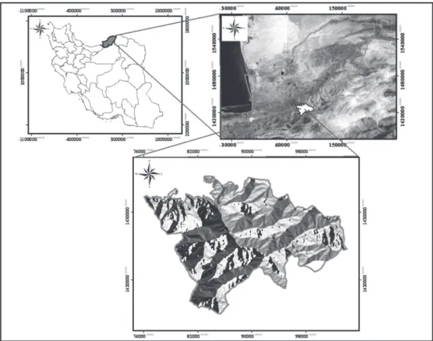
STUDY AREA
Watershed 88 with borders between Ali Abad and
Ramian counties. The study area with the area of
about 30554ha is located between N 36° 44' 08''
to 36° 55' 32'' and E 54° 50' 06'' to 55° 09' 42''.
The elevation ranges from 119m to 2570m a. s. l.
The whole area covers four forest management plans
inclusive of Rezaeian (compartments 1, 2, 3 and 4),
Sorkhdari (compartments 1 and 2), ZarrinGol and
Kaboodval. In addition nature preserve of Pune
Aram and Afra Takhte are within the area.
METHOD
First step: to collect the existing statistics and
information
In this stage a database was created inclusive of digitized
topographic maps, images of TM+ satellite taken in
2010 provided by Golestan Povince General Office of
Natural Resources and Watershed Management, and
also collecting some data about annual precipitation,
annual temperature, the relative humidity of air, soil
type, type and density of vegetation cover and lithology.
One of some of the resources used, were maps and
executive and feasibility study reports of the forest
management plans in the watershed 88 (Kaboodval,
Rezaeian, Zarrin Gol and Sorkhdari) produced by
Golestan Povince General Office of Natural Resources
and Watershed Management during 2008-2010.
Second step: field works
The map of the location of
T. baccata
preserves was
created using GPS. Then weighting was done based
on the
T. baccata
presence in each class of the map.
Third step: information analysis and presenting
the results
In this step analysis and data collection and also
parameters weighting based on the paired com parison
in the AHP were done and subsequently adequate
Figure 1 - Study site location in Golestan Province and Iran.
Then
T. baccata
locating was separated in two classes:
Adequate and Inadequate. In order to combine the maps
the Bolian logic based on function "And" was used. For
combining the maps with relational models, ranking
and the AHP, final maps were produced from combined
maps (sum function) (Parhizkar and Ghaffari Gilandeh
2006). In the end the results of these two methods
were compared. In recent years some models with
the ability of providing accurate spatial information
were developed using the GIS. The process stages:
recognition, providing needed data, determining the
effective factors, accurate recognition of study area,
data collecting, preparing map and producing the output
maps. An important thing in locating is the extraction of
environ mental factors and their classification to several
effective parts that requires the accurate recognition of
the importance of each factor.
RESULTS
THE RESULTS OF BOLIAN METHOD IN LOCATING T. baccata
Each map the locations with adequate of T. baccata
presence valued as 1 and the location inadequate of
T. baccata
valued as 0.
Elevation: after producing the Bolian map of
elevation it was revealed that the richest elevation
class of
T. baccata
presence is 1200-1600m a. s. l.
with an area of 8591 ha and the biggest area without
T. baccata
presence possibility was 5058 ha at the
elevation class of 400-800 m a. s. l.
Slope: producing the Bolian map of slope it
was noted that the richest slope class of
T. baccata
presence was slope class of 25-50% with the area
of 14610ha and the greatest area without
T. baccata
Slope aspect: producing the Bolian map of
slope aspect it was noted that the richest slope
aspect class of
T. baccata
presence was northern
slope aspect class with the area of 6524ha and the
greatest area without
T. baccata
presence possibility
was eastern slope aspects with 2324 ha area.
Soil type: the soil type map was also created
using Bolian method based on presence and absence
of
T. baccata
. The biggest area of a soil type with
the most
T. baccata
presence was the type 1.2.1 with
the area of 9371ha and the largest area without
T.
baccata
inadequate was related to the soil type 1.1.2
with 3884ha area.
Geology: The geological map was also
pro-duced using Bolian method based on presence
and absence of
T. baccata
. The greatest area of
T.
baccata
presence was related to the CM formation
with 11899ha area and the greatest area without
T.
baccata
adequate was related to the Qs.d formation
with the area of 1531ha.
Relative humidity: the map of relative humidity
was also created using Bolian method based on
presence and absence of
T. baccata
. The greatest
area of
T. baccata
adequate was related to the class
70.33-70.69 with 6689ha area and the greatest area
without
T. baccata
adequate was in the class
70.69-71.05 with the area of 6531ha.
Annual precipitation: the map of annual
precip-itation was produced using Bolian method based on
presence and absence of
T. baccata
. The greatest
area of
T. baccata
adequate was related to the class
560-640 mm with 11461ha area and the greatest
area without
T. baccata
presence was related to the
precipitation class of more than 720mm with the
area of 2368 ha.
Temperature: the map of annual temperature
was also produced using Bolian method based on
presence and absence of
T. baccata
. The greatest
area of
T. baccata
adequate was related to the class
17-17.80°C with 14637ha area and the greatest area
without
T. baccata
presence was related to the class
17.80-18.60°C with the area of 5216ha.
Tree cover type: the map of tree cover type was
created using Bolian method based on presence
and absence of
T. baccata
. The greatest tree cover
type area of
T. baccata
adequate was in the type
Carpineto-Quercetum
with 8363ha area and the
greatest area without
T. baccata
presence was
related to the type
Parrotio-Carpinetum
with the
area of 2100ha.
Vegetation canopy cover density: the map of
vegetation canopy cover density was created using
Bolian method based on presence and absence of
T.
baccata
. The greatest area of
T. baccata
adequate
in the vegetation canopy cover density classes was
related to the class of more than 80% with 15171ha
area and the greatest area without
T. baccata
presence was related to the class of 20-40% with
the area of 1321ha.
RESULTS OF MCEMETHOD FOR LOCATING T. baccata
Score layer of T. baccata locating by AHP
The effective factors on
T. baccata
locating were
weighted using paired comparisons of Expert
Choice 11 software by 4 academic staff specialists
and 1 executive specialist (Table I). According
to the experts opinions the effective factors were
weighted as follow: precipitation classes=0.100,
slope classes=0.084, lithology classes=0.039, aspect
classes=0.110, relative humidity classes=0.135, soil
type classes=0.083, tree cover type classes=0.059,
vegetation canopy cover density classes=0.147,
elevation classes=0.146 and temperature classes=0.097.
Therefore vegetation canopy cover density has been
identified as the most important factor with the
weight of 0.147. An important note about paired
matrix is that the amount of incompatibility rate
must be less than 0.1 (Sabeti 1994). The amount of
incompatibility rate in this research is 0.054 which
means a high compatibility.
Elevation: after weighting of the produced
was 1200-1600m a. s. l. and the minimum weight
or the most inappropriate elevation class was the
elevation class of less than 400 m a. s. l.
Slope: after weighting of the produced slope
classes it was found that the maximum weight or
the most appropriate slope class was 25-50% and
the minimum weight or the most inappropriate
class was the slope class of more than 100%.
Slope aspect: after weighting of the produced
slope aspect classes it was found that the maximum
weight or the most appropriate slope aspect class
was the northern slope and the minimum weight or
the most inappropriate class was eastern slope.
Lithology: after weighting of the produced
lithology classes it was cleared that the maximum
weight or the most appropriate Lithology class was
the dckh formation and the minimum weight or the
most inappropriate class was the Qs.d formation.
Relative humidity: subsequent to weighting of
the produced relative humidity classes it was found
that the maximum weight or the most appropriate
relative humidity class was 69.97-70.33% and the
minimum weight or the most inappropriate class
was 70.69-71.05%.
Precipitation: after weighting of the produced
precipitation classes it was found that the maximum
weight or the most appropriate precipitation class
was 560-640mm and the minimum weight or the
most inappropriate class was the precipitation class
of more than 720mm.
Temperature: after weighting of the produced
temperature classes it was found that the maximum
weight or the most appropriate temperature class
was 17-17.80°C and the minimum weight or the
most inappropriate class was the temperature class
of more than 19.5°C.
Soil type: after weighting of the produced
soil type classes it was revealed that the maximum
weight or the most appropriate class was the type
1.1.1 and the minimum weight or the most
ina-ppropriate class was the type 2.1.3.
Vegetation canopy cover density: subsequent
to weighting of the produced vegetation canopy
cover density classes it was found that the
maximum weight or the most appropriate class
was related to the density class of more than 80%
and the minimum weight or the most inappropriate
class was the density class of less than 20%.
TABLE IWeighting of T. baccata environmental factors by AHP method.
No. Expert parameter Forest
expert
PhD of
Forestry
PhD of
Forestry
PhD of
Forestry
PhD of
Forestry Mean
1 Slope aspect 0.132 0.082 0.151 0.114 0.073 0.110
2 Slope 0.053 0.098 0.151 0.069 0.049 0.084
3 elevation 0.158 0.148 0.151 0.149 0.122 0.146
4 vegetation canopy cover density 0.105 0.110 0.249 0.126 0.146 0.147
5 Relative humidity 0.132 0.131 0.097 0.148 0.171 0.135
6 Temperature 0.105 0.114 0.067 0.103 0.098 0.097
7 Precipitation 0.105 0.099 0.043 0.105 0.147 0.100
8 tree cover type 0.026 0.102 0.064 0.054 0.049 0.059
9 Soil 0.105 0.083 0.014 0.090 0.122 0.083
10 Lithology 0.079 0.033 0.014 0.043 0.024 0.039
Total 1 1 1 1 1 1
Incompatibility
Tree cover type: after weighting of the produced
tree cover type classes it was revealed that the maximum
weight or the most appropriate class was related to the
type
T. baccata
and the most inappropriate class was
related to the type Parrotio-Zelkovetum.
DISCUSSION
THE FINAL MAP RESULTED FROM BOLIAN METHOD
The final map resulted from Bolian method=
(Bolian map of precipitation classes) × (Bolian map
of slope classes) × (Bolian map of lithology classes)
× (Bolian map of slope aspect classes) × (Bolian
map of relative humidity classes) × (Bolian map of
soil type classes) × (Bolian map of tree cover type
classes) × (Bolian map of vegetation canopy cover
density classes) × (Bolian map of elevation classes)
× (Bolian map of temperature classes).
ANALYSIS OF T. baccataEVALUATION RESULTS BY
BOLIAN METHOD
The result of location using Bolian method showed
that the maximum area of
T. baccata
adequate is
related to the elevation class of 1200-1600m a. s. l.
and the maximum area of
T. baccata
inadequate is
related to the elevation class of 400-800m a. s. l. Also
the most typical part of the study area (Pone Aram)
is located at the elevation of 1300 to 1470m a. s. l.
which is in accordance with the results of this study.
Between the slope map with
T. baccata
locating by Bolian method showed that slope class
of 25-50% and the maximum area of
T. baccata
inadequate is related to the slope class of more than
100%. The maximum area of T. baccata
adequate is
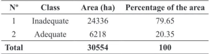
Nº Class Area (ha) Percentage of the area
1 Inadequate 24336 79.65
2 Adequate 6218 20.35
Total 30554 100
TABLE II
Distribution of T. baccata locating classes using Bolian method.
related to the northern slope class and the maximum
area of
T. baccata
absence possibility is related to
the eastern slope class. The aforementioned result
is in agreement with the results of Esmailzadeh and
Hoseini (2006) that they found significant difference
among plant ecological groups due to physiographic
factors of elevation, slope and slope aspect.
The maximum distribution of
T. baccata
is
related to the precipitation class of 560-640mm and
the maximum area of
T. baccata
absence possibility
is related to precipitation class of more than 700mm.
Also the maximum area of
T. baccata
adequte is
related to temperature class of 17-17.80°C and the
maximum area of
T. baccata
inadequate is related
to temperature class of 17.80-18.60°C. In relation
to the relative humidity the maximum area of
T.
baccata
adequate estimated to occur in the class of
69.97-70.33% and the maximum area of T. baccata
inadequate in 70.69-71.05%.
After overlapping the maps from Bolian
method with lithologic map the maximum area of
T. baccata
adequate has been estimated to be in the
Pd formation and the maximum area of
T. baccata
inadequte estimated to occur in Qs.d formation.
The biggest area of a soil type with the most
T.
baccata
presence was the type 1.2.1 and the largest
area without
T. baccata
inadequate was related to
the soil type 1.1.2.
The greatest area of
T. baccata
presence
possibility in the vegetation canopy cover density
classes was related to the class of more than 80%
and the biggest area without
T. baccata
presence
was related to the class of 20-40%. Also the greatest
tree cover type area of
T. baccata
adequate was in
the type
Carpineto-Quercetum
and the greatest area
without
T. baccata
presence was related to the type
Parrotio-Carpinetum
.
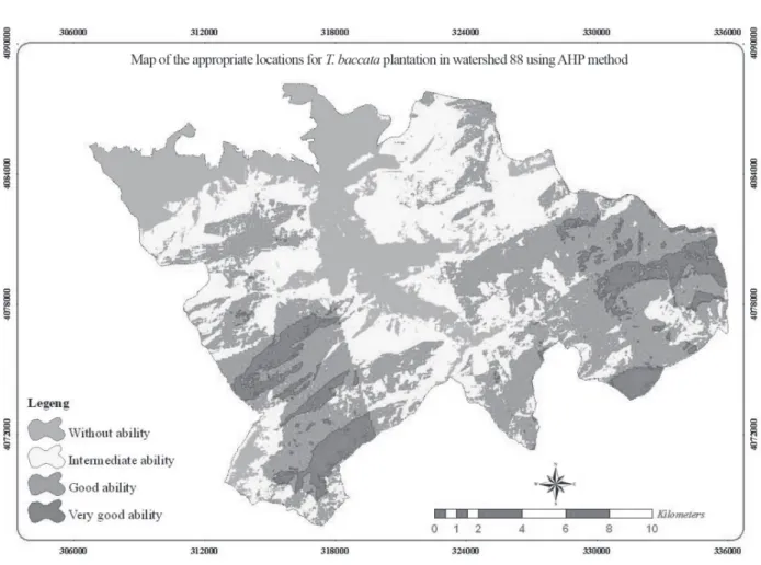
THE FINAL MAP RESULTED FROM MCEMETHOD
plantation was classified in 4 classes by summing
the multiplied results of factors map and turning
points of cumulative frequency of pixels (Figure 2
and Table III).
The final map resulted from MCE method=
(rate map of precipitation classes × 0.100) + (rate
map of slope classes × 0.084) + (rate map of lithology
classes × 0.039) + (rate map of slope aspect classes
× 0.110) + (rate map of relative humidity classes ×
0.135) + (rate map of soil type classes × 0.083) +
(rate map of tree cover type classes × 0.059) + (rate
map of vegetation canopy cover density classes ×
0.147) + (rate map of elevation classes × 0.146) +
(rate map of temperature classes × 0.097).
TABLE III
Distribution of T. baccata locating classes using AHP method.
Figure 2 - Map of T. baccata locating classes using AHP method.
No. T. baccata growth Area (ha) Percentage of the area
1 poor 6181 20.22
2 Average 10909 35.69
3 Good 10982 35.96
4 Very good 2482 8.13
ANALYSIS OF T. baccataLOCATION EVALUATION RESULTS BY MCEMETHOD
The results of weighting by AHP method showed that
the maximum weight was related to vegetation canopy
cover density also the parameter of lithology had the
least weight. These results confirm that lithology is a
low impact factor in locating this species.
By overlapping the map produced from MCE
method with maps of used parameters it was found
that
T. baccata
adequate in the elevation class of
1200-1600m a. s. l. will have the maximum area and
in elevation class of less than 400m a. s. l. will has
the least one. Also by overlapping the map of slope
aspect classes it has been found that the northern
slope has the largest area from the ability class of
very good and also has the most amount of
T. baccata
adequate, while the areas with no slope (flat) and
also eastern and south eastern slope classes cannot
be classified in the class of "very good ability".
Overlapping the map produced by MCE method
with the maps of slope classes showed that the slope
class of 25-50% has the most amount of T. baccata
adequate (very good ability) and the slope class of
more than 100% has the least. Also Pd formation
had the highest level in very good ability class, and
Qs.d formation had the least
T. baccata
adequate.
The vegetation canopy cover density class of more
than 80% has the most amount of T. baccata
adequate
in the ability class of good while the vegetation canopy
cover density class of less than 20% is
T. baccata
inadequate in classes of good and very good.
Tree cover type of
Carpinetum-betulae
has the
highest possibility of
T. baccata
presence.
Overlapping the map produced by MCE
method with the maps of relative humidity classes
showed that the class of 69.97-70.33% has the most
areas of
T. baccata
adequate and the class of
70.69-71.05 has
T. baccata
inadequate.
Also precipitation class of 560-640 mm has
the most amount of
T. baccata
presence possibility
while the class of more than 720 mm has the most
amount of areas without
T. baccata
growth ability.
Temperature class of 17-17.80°C has the most
amount of
T. baccata
adequate in the ability class
of very good and the class of more than 19.5 has
most area
T. baccata
inadequate.
Soil type of 1.1.1 has the most amount of
T. baccata
adequate in the ability class of very good while the
type 2.2.2 has most area
T. baccata
inadequate.
Matching the map of soil type with the final layer
showed that
T. baccata
species has different
distribution in different soil types.
CONCLUSION
Results showed that
T. baccata
species is sensitive to
different factor changes and its distribution has direct
relationship with ecological factors particularly
climatic and physiographic factors (Mossadegh
1993, Salmanmahiny and Kamyab 2009). Also there
is a high correspondence between the layer of
T.
baccata
species preserves in the study site with the
final produced layer of MCE and Boilan method.
The results also showed that
T. baccata
has different
ecological demands and it is possible to achieve
good results by combining different layers. Also
regarding the used factors and allocated weights by
experts the differentiation between effective actors
on
T. baccata location has been confirmed. Using
the results of this investigation it is possible to locate
areas for
T. baccata
presence and to execute a plan
in order to facilitate
T. baccata
plantation in northern
forests of Iran (watershed 88). And at last regarding
the evaluation using MCE and Bolian method it
has been detect
T. baccata
location by dynamic
ecological parameters the MCE method due to its
hierarchy weighting (and not as appropriate and
inappropriate) is more suitable than Bolian method.
RESUMO
Taxus baccata é uma espécie nativa das florestas do Cáspio e é considerada como a identificação dessas florestas por
Aram da província de Golestan. Para isto, foram utilizados
métodos de avaliação de diferentes critérios baseados
no processo hierárquico de análise. A princípio, neste
processo os índices naturais necessários e eficazes foram usados como 10 parâmetros. Em seguida, o mapa final de
áreas adequadas para o plantio de T. baccata foi produzido
com base nos modelos de Bolian e MCE. De acordo
com os resultados do modelo de Bolian, aproxidamente 6218 ha da área total do local de estudo (30.554ha) foram estimados como adequados e semi adequados e 24.336ha
foram estimados como impróprios pelo modelo MCE. Isto
mostrou que, de toda a área de estudo, 30.554ha, cerca
de 2.482 são adequados para plantação de T. baccata e 6181ha não são adequados para o plantio de T. baccata.
Considerando os resultados dos métodos de MCE e Bolian concluiu-se que, para os parâmetros ecológicos dinâmicos em delimitação de áreas adequadas para plantação de T. baccata plantação de MCE é mais apropriado do que de Bolian. Usando os resultados deste estudo, é possível adequar áreas para T. baccata e executar um plano para facilitar o plantio de T. baccata em florestas do norte do
Irã (bacias hidrográficas 88).
Palavras-chave: Taxus baccata, localização, MCE,
Bolian, Pone Aram, Irã.
REFERENCES
AHMADI SANI N, BABAEI KAFAKI S AND MATAJI A. 2011. Ecological Possibility of Ecotourism Activities in the
Northern Zagros Forests Using MCDM, GIS and RS. Town and Country Planning 3(4): 45-64.
DANEHKAR A AND MAHMOODI B. 2008. Criteria and standards of ecotourism sites planning. National document of ecotourism. National ecotourism committee.
DARGAHI D. 2000. Ecological study on T. baccata in northern forests of Iran. PhD thesis, Tarbiat Modares University. DELAVAR K. 1998. Investigating the effects of different
environmental factors on taxol density in mature tree and tissue culture of T. baccata. MSc thesis, Tarbiat Modares University. (Unpublished).
EMAMI A, SHAMS ARDEKANI MR AND MEHREGAN I. 2004. Illustrated dictionary of medical plants. Traditional Medicine and Materia Medica Research Center, Shahid Beheshti University of Medical Sciences.
ESMAILZADEH O AND HOSEINI SM. 2006. The relationship between plant ecological groups with plant biodiversity indices in Afra Takhte T. baccata preserve. J Environ Stud
33(43): 21-30.
GEOLOGICAL SURVEY OF IRAN. 2004. 1:100000 geological map of the country.
HABIBI KASEB H AND LESSANI MR. 1985. Investigation on soil and stand quality of T. baccata in Iran. Iran J Nat Resour 39: 13-27. JAVANSHIR K. 1994. Coniferous. Research Institute of Forests
and Rangelands 30: 547.
LESSANI MR. 1999. Yew T. baccata L. Research Institute of Forests and Rangelands. Technical Publication 210(1999): 71-73. MOSSADEGH A. 1993. Yew tree. Research report of University
of California, Berkeley.
PARHIZKAR A AND GHAFFARI GILANDEH A. 2006. Geographical
information system and Multi-Criteria Evaluation. Samt
Publication, 180 p.
POORBABAEI H, JAVANSHIR K, MAKHDOOM M AND ZOBEIRY
M. 1998. Common yew distribution and biodiversity with along wooden species of its stands in Gilan forests. J
Environ Stud (21-22): 29-40.
SABETI H. 1994. Forests, trees and shrubs of Iran. Yazd University. 2nd ed., p. 741-743.
SALMANMAHINY A AND KAMYAB H. 2009. Applied remote sensing and GIS with Idrisi. Mehr Mahdis Publication, Tehran, p. 582.
VERDIAN RIZI MR. 2004. Extraction, Separation and purification of taxids existing in T. baccata branches. Doctor of Pharmacy thesis. Faculty of Pharmacy, Tehran University of Medical Sciences.