Abstract : the authors present and discuss the radiocarbon dates obtained until now for the prehistoric site of Castelo Velho de Freixo de Numão. These results, associated with stratigraphic analysis, indicate that the site was mainly occupied between 3000 and 1300 BC.
Key-words : C14 dates; chronology; Castelo Velho.
Resumo: Os autores apresentam e discutem as datas de radiocarbono obtidas até hoje para o sítio pré--histórico de Castelo Velho de Freixo de Numão. Tais datas, conjugadas com a análise estratigráfica, permitem concluir que o local foi ocupado sobretudo entre 3000 e 1300 antes de Cristo.
Palavras-chave: Datas de Carbono 14; cronologia; Castelo Velho.
1. INTRODUCTION (S.O.J.)
1.1. The prehistoric site of Castelo Velho de Freixo de Numão (Vila Nova de Foz Côa) (Fig. 1) has been investigated since 1989, and several Masters theses from the Faculty of Letters of the University of Oporto, as well as many other analytical and synthetic studies, have resulted (Jorge, S.O., 1993, 1994, 1998, 1999, 2001, in press a, b; Jorge, S.O. et al, 1998/99; Antunes, M.T. & Cunha, A.S., 1998; Figueiral, I., 1998, 1999).
The chronology of Castelo Velho was introduced (Jorge, S.O., 1993, 1998) by the presentation of 7 C14 dates. In 1993, with the publication of 6 radiocarbon dates and with a still limited knowledge of the associated materials, the following diachronic overview of the site was proposed: – initial occupation of the hill, around 3000 BC; – construction of an architectural structure at the top, between c. 2900 and c. 2200 BC; – maintenance of a
FREIXO DE NUMÃO (NORTHERN PORTUGAL):
DATA AND PROBLEMS
by
Susana Oliveira Jorge* & Antonio Rubinos**
* Departamento de Ciências e Técnicas do Património (DCTP), Faculdade de Letras da U. P., Portugal. E-mail: vojsoj@mail.telepac.pt
‘fortified settlement’ until its desertion, at around 1700 BC. The first and second phases correspond to the mid/end of the Chalcolithic period and the third to the early Bronze Age. In 1998, a further C14 date was presented and, using as yet unpublished information on radiocarbon dates, the timeframe for the site was extended, now stretching from c. 3000 to c. 1300 BC. Thus it is assumed that the site (now called a ‘monument’) would have been operational between the mid-Chalcolithic and the middle Bronze period. The continued occupation of the site throughout this period is also stressed.
From the stratigraphic perspective, the first phase (3000/2900 BC) is considered to correspond to layer 4; the second phase (2900/2200 BC) to layer 3, and the third phase (2200/1300 BC) to layer 2. Since 1998 it has also been suggested that the site may have been reoccupied later, in the Middle Ages, leaving faint traces that would require evaluation later.
1.2. Following excavation work between 1997 and 2001, and given the type of material found in the different layers, such as pottery, it appeared that the overall chronological limits of the phases of construction and occupation of the site needed to be rethought. The present opinion is that, in the light of field data (structural analysis, stratigraphy, associated materials, etc) and other data (such as type of pottery), the timeframe in the hypothesis needs to be slightly adjusted:
– Castelo Velho de Freixo de Numão would initially have been occupied around 3000 BC, on a spur at a height of approximately 681 m. This occupation, which resulted in the construction of a tower, combustion structures and paving (scattered over the surrounding area) corresponds to layer 4 of the site. This first phase of occupation appears to have been short-lived.
– After this first phase, the site underwent profound alteration. At the top of the spur, a ‘monument’ was built of stone and clay, consisting of an elliptical enclosure surrounded by a platform and various ‘ramps’ (Fig. 2). In this phase, the ‘monument’ consisted of several structures on the top of the spur, both inside and outside the enclosure. The sediments from this second phase of occupation and construction are generally of a yellowish colour and correspond to layer 3 of the site. This layer would have coincided with the construction and prolonged use of the main structures and spaces in the upper part of the ‘monument’. Thus, unlike layer 4, which corresponds to a relatively short phase of the lifespan of the site, layer 3 seems to cover a long period of time, during which a complex monumental space was built, used, abandoned and reoccupied. Analysis of pottery found in this layer reveals not only the predominance of the ‘penteada’ style of decoration, but also the importance of the so-called V3 style (Jorge, S.O., 1986, vol. I-A, p. 725, fig. 27). This type of decoration arose during the 3rd millennium BC in Trás-os--Montes and Alto Douro (Jorge, S.O., 1986; Sanches, M.J., 1997). However, it may have persisted until the end of the 3rd millennium BC at Buraco da Pala (Mirandela) (Sanches,M.J., 1997, p. 108), or maybe even beyond this date, as is suggested by the 2 sigma calibration of one of the C14 dates from Castelo de Aguiar II (Vila Pouca de Aguiar) (UGRA 181 – 2550 – 1740 cal BC) (Jorge, S.O., 1986, vol. I--A, p. 789, fig. 37; Sanches, M.J., 1997, vol I, p. 176). This decorative style must have arisen late, following the assimilation and local reworking of the bell-beaker
additive pattern (Jorge, S.O., 1986). Thus, given the widespread survival of the V3 style, there would seem to be a need to investigate whether it also occurred at Castelo Velho. If so, then we have to accept that the second building phase, begun around 2900 BC, may have continued until the beginning of the 2nd millennium BC. In other words, the way is now open for the hypothesis that the second period (corresponding to the building of a monumental structure that remained intact until it was abandoned) may have crossed the conventional boundaries dividing the Chalcolithic from the early Bronze period. If that is the case, then layer 3 cannot be exclusively Chalcolithic, but must also correspond to part of the early Bronze period.
– At a certain point the ‘monument’ underwent profound alterations: some structures were destroyed, others were erected, and the ‘ramps’ and platforms were reinforced. However, the initial architectural design, of an enclosure surrounded by a platform and ‘ramps’, remained intact. The sediments connected with this 3rd phase of occupation/reconstruction are generally brownish in colour, and correspond to layer 2. It is in this phase that Cogeces pottery was found, which has been dated to the beginning of the 2nd millennium BC in the case of some sites not only on the Meseta but also in the Peninsula (Pereira, L.S., 1999). Taking this into account, the third period of construction could therefore have occurred between the beginning of the 2nd millennium BC and approx. 1300 BC or, in other words, between the
middle of the early Bronze and the middle Bronze Age.
– Finally, a quantity of stone was deliberately deposited on the site, thereby damaging it. In the places where this is best preserved, there are embankments of stone and clay which completely concealed the structures of layer 2. This covering with stones is unlikely to have extended beyond the conventional boundary of 1300/ /1200 BC.
– Only much later, in the Middle Ages, was Castelo Velho occupied again, sparsely and for a brief period. The remains of this settlement show that the layers of stone and clay that had ‘encased’ the Bronze Age ‘monument’ were dismantled in a few sectors, without however causing much destruction. We shall see later whether the available absolute chronology confirms the type of materials found in layer 1 and the top of layer 2, resulting from medieval intrusion in the pre-historic monument1.
2. THE C14 DATES FROM CASTELO VELHO (A. R.)
There are at present thirty C14 dates available for the site of Castelo Velho de Freixo de Numão, distributed across the stratigraphic layers as follows:
– layer 2: 6 dates – layer 2/layer 3: 1 date – layer 3: 16 dates – layer 4: 7 dates
Table 1
SAMPLE LAYER LABORATORY C 14 AGE CALIBRATED AGE
(years BP) (cal BC years)
7 4 ICEN-882 4980 ± 100 3979-3631 (93.9%) 3561-3538 (1.5%) 3 4 ICEN-535 4170 ± 110 3018-2465 (95.4%) 1 3 Sac-1518 4130 ± 80 2884-2552 (88.7%) 2540-2492 (6.7%) 5 3 ICEN-785 4110 ± 60 2877-2560 (90.1%) 2524-2495 (5.3%) 23 3 GrN-23512 4020 ± 100 2876-2290 (95.4%) 4 3 ICEN-536 3980 ± 120 2875-2197 (94.4%) 2164-2145 (1.0%) 16 3 ICEN-1165 3990 ± 110 2872-2802 (7.3%) 2783-2202 (88.1%) 2860-2810 (14.6%) 29 3 CSIC-1706 4073 ± 45 2755-2721 (5.3%) 2702-2472 (75.5%) 26 3 Ua-17647 3945 ± 75 2623-2200 (95.4%) 10 4 ICEN-1167 3700 ± 180 2579-1620 (95.4%) 9 4 ICEN-1169 3770 ±130 2569-2517 (2.1%) 2499-1877 (93.3%) 30 3 Ua-17648 3850 ± 75 2492-2128 (92.6%) 2083-2041 (2.8%) 25 3 CSIC-1655 3917 ± 34 2474-2292 (95.4%) 2456-2420 (1.4%) 14 3 ICEN-1170 3660 ± 130 2404-2360 (2.2%) 2354-1736 (90.8%) 1713-1691 (1.0%) The C14 dates are shown in Tables 1 and 2. Calibration was made by the Oxcal 3.5 programme from the University of Oxford (Bronk Ramsey, 1995), using the latest available calibration curve (INTCAL 98, Stuiver et al, 1998). The calibration was at 95.4% (2 sigma). The different intervals obtained by calibration are indicated, as are the respective percentages. International nomenclature was maintained, according to the decision of the 1st Congress on Peninsula Archaeology, in Oporto (Cabral, J.M., 1995), which added to the calibrated dates the terms cal BC or cal AD according to whether the date was understood as before or after the birth of Christ.
Table 1 presents the C14 dates grouped in order of decreasing age. Table 2 shows the dates according to layer, and, within that, also ordered by decreasing age.
SAMPLE LAYER LABORATORY C 14 AGE CALIBRATED AGE (years BP) (cal BC years)
6 2 ICEN-885 3570 ± 100 2199-2157 (2.4%) 2151-1682 (93.0%) 11 3 ICEN-1164 3520 ± 110 2140-1600 (93.4%) 1569-1528 (2.0%) 18 3 CSIC-1333 3650 ± 28 2135-2079 (24.5%) 2054-1939 (70.9%) 15 3 ICEN-1168 3420 ± 120 2028-1992 (2.1%) 1982-1439 (93.3%) 24 4 GrN-23510 3460 ± 80 1960-1600 (92.2%) 1571-1528 (3.2%) 19 4 GrA-9442 3380 ± 40 1749-1597 (82.3%) 1591-1525 (13.1%) 12 4 ICEN-1166 3130 ± 150 1739-1704 (1.4%) 1696-996 (94.0%) 1731-1720 (1.2%) 27 2/3 CSIC-1713 3302 ± 50 1689-1490 (90.2%) 1479-1452 (3.9%) 2 2 Sac-1519 3250 ± 50 1680-1670 (1.8%) 1635-1426 (93.6%) 13 3 ICEN-1171 3200 ± 45 1601-1560 (5.0~%) 1531-1390 (90.4%) 20 2 GrN-23507 3150 ± 45 1520-1368 (82.7%) 1361-1313 (12.7%) 1500-1469 (4.7%) 21 3 GrA-9241 3110 ± 50 1464-1259 (89.4%) 1231-1219 (1.3%) 28 3 CSIC-1656 1899 ± 38 24-43 cal AD (5.3%) 49-227 cal AD (90.1%) 8 2 ICEN-881 900 ± 45 1024-1221 cal AD (95.4%) 22 2 GrN-23508 750 ± 50 1184-1305 cal AD (90.8%) 1365-1387 cal AD (4.6%) 17 2 CSC-1334 676 ± 26 1280-1320 cal AD (50.1%) 1351-1389 cal AD (45.3%) Carbon 14 dates of the site of Castelo Velho (Freixo de Numão). Calibration was done using the OxCal 3..5 programme, curve INTCAL 98 (Stuiver et al , 1998), to 2 sigma (95.4% of probabilities). The laboratories contributing to the analyses were: ICEN or Sac (Instituto Tecnológico e Nuclear, Portugal); GrN/GrA (Centre for Isotope Research, Holland); CSIC (Instituto “Rocasolano”-CSIC, Spain); Ua (University of Uppsala, Sweden).
Table 2
CARBON 14 DATES AT CASTELO VELHO BY LAYERS
SAMPLE LAYER LABORATÓRY C 14 AGE CALIBRATED AGE
(BP years) (cal BC years)
7 4 ICEN-882 4980 ± 100 3979-3538 3 4 ICEN-535 4170 ± 110 3018-2465 10 4 ICEN-1167 3700 ± 180 2579-1620 9 4 ICEN-1169 3770 ± 130 2569-1877 24 4 GrN-23510 3460 ± 80 1960-1528 19 4 GrA-9442 3380 ± 40 1749-1525 12 4 ICEN-1166 3130 ± 150 1739-996 1 3 Sac-1518 4130 ± 80 2884-2492 5 3 ICEN-785 4110 ± 60 2877-2495 23 3 GrN-23512 4020 ± 100 2876-2290 4 3 ICEN-536 3980 ± 120 2875-2145 16 3 ICEN-1165 3990 ± 110 2872-2202 29 3 CSIC-1706 4073 ± 45 2860-2472 26 3 Ua-17647 3945 ± 75 2623-2200 30 3 Ua-17648 3850 ± 75 2492-2041 25 3 CSIC-1655 3917 ± 34 2474-2292 14 3 ICEN-1170 3660 ± 130 2456-1691 11 3 ICEN-1164 3520 ± 110 2140-1528 18 3 CSIC-1333 3650 ± 28 2135-1939 15 3 ICEN-1168 3420 ± 120 2028-1439 13 3 ICEN-1171 3200 ± 45 1601-1390 21 3 GrA-9241 3110 ± 50 1500-1219 28 3 CSIC-1656 1899 ± 38 24-227 cal AD 27 2/3 CSIC-1713 3302 ± 50 1731-1452 6 2 ICEN-885 3570 ± 100 2199-1682 2 2 Sac-1519 3250 ± 50 1680-1426 20 2 GrN-23507 3150 ± 45 1520-1313 8 2 ICEN-881 900 ± 45 1024-1221 cal AD 22 2 GrN-23508 750 ± 50 1184-1387 cal AD 17 2 CSIC-1334 676 ± 26 1280-1389 cal AD
3. CRITICAL COMMENTARY UPON THE C14 DATES (S. O. J. & A. R.)
(Fig. 3 and Tables 1 and 2)
3.1. The C14 dates and the archaeological context (S. O. J.)
Layer 4
– Sample 7 – ICEN-882 – 4980 ± 100 BP = 3979 – 3538 cal BC
Accumulation of carbon in square M’7, at c. 10 cm below the present surface, in an area consisting of greyish sediments, interpreted as corresponding to layer 4. This sector has limited stratigraphic potential.
The date points to a very distant time span, which has not so far permitted archaeological observation of layer 4.
– Sample 3 – ICEN-535 – 4170 ± 110 BP = 3018 – 2465 cal BC
Combustion area, located in square A’4, at c. 60 cm beneath the present surface. Nearby is a wall delimiting the upper enclosure, which corresponds to layer 3. Despite an enormous margin of error, this is the only C14 date that is supported by archaeological observation of layer 4.
– Sample 10 – ICEN-1167 – 3700 ± 180 BP = 2579 – 1620 cal BC
Structured fireplace, opening onto the bedrock, located in square I’6, at c. 80 cm beneath the present surface. Nearby is a wall delimiting the upper enclosure, corresponding to layer 3. This date is not supported by archaeological observation of layer 4.
– Sample 9 – ICEN-1169 – 3770 ± 130 BP = 2569 – 1877 cal BC
Combustion area, located in square J’7, at c. 50 cm beneath the present surface. This date is not supported by archaeological observation of layer 4.
– Sample 24 – GrN-23510 – 3460 ± 80 BP = 1960 – 1528 cal BC
Combustion area located in square B’14, at c. 50 cm beneath the present surface, in the vicinity of a bastion contemporary with layer 4. This date is not supported by archaeological observation of layer 4.
– Sample 19 – GrA-9442 – 3380 ± 40 BP = 1749 – 1525 cal BC
Accumulation of carbon in square F 11, at c. 75 cm beneath the present surface, in front of an entrance to the upper enclosure, open on layer 3. This date is also unsupported by archaeological observation of level 4.
– Layer 12 – ICEN-1166 – 3130 ± 150 BP = 1739 – 996 cal BC
Combustion area, located in square I’7, at c. 40 cm beneath the present surface. In the vicinity is a level 3 structure situated in front of one of the entrances to the upper enclosure. This date is not supported by archaeological observation of level 4.
Samples 7, 9, 24, 19 are from areas where ‘entrances’ were subsequently constructed into the upper enclosure, all associated with level 3. These ‘entrances’ also suffered
destructive action over the years, which could have affected the foundations and moved the sediments connected with them. These activities from the prehistoric era may have affected the carbon in level 4, without this being noticeable in the stratigraphic analysis of the contexts collected for dating.2
Layer 3
– Sample 1 – Sac-1518 – 4130 ± 80 BP = 2884 – 2492 cal BC
Combustion area, located in square E 13, at c. 60 cm beneath the present surface, next to the wall delimiting the upper enclosure. It is the area which, within the upper enclosure, has the greatest stratigraphic potential. This date, which has a narrower margin of error, is consistent with archaeological observation of the first phase of formation of layer 3.
– Sample 5 – ICEN-785 – 4110 ± 60 BP = 2877 – 2495 cal BC
Structured fireplace, located in square B’5, at c. 30 cm beneath the present surface (under stones). This date, which has a narrower margin of error, is consistent with archaeo-logical observation of the first phase of formation of layer 3.
– Sample 23 – GrN-23512 – 4020 ± 100 BP = 2876 – 2290 cal BC
Combustion area, within a ritual structure containing buried human remains, located in square I 11A, at c. 50 cm beneath the present surface. Despite a large error margin, this date does not contradict the archaeological observation of layer 3 and the stratigraphic analysis of the ritual structure.
– Sample 4 – ICEN-536 – 3980 ± 120 BP = 2875 – 2145 cal BC
Combustion area, located at the junction of squares A 4 and A 5, at c. 50 cm beneath the present surface, near a wall delimiting the upper enclosure. Despite the enormous margin of error, this date does not contradict archaeological observation of layer 3.
– Sample 16 – ICEN-1165 – 3990 ± 110 BP = 2872 – 2202 cal BC
Combustion area, located in square J’7, at c. 50 cm beneath the present surface, at the base of layer 3. Despite the large margin of error, this date does not contradict archaeological observation of layer 3.
– Sample 29 – CSIC-1706 – 4073 ± 45 BP = 2860 – 2472 cal BC
Accumulation of carbon in square I 9, at c. 50 cm beneath the present surface. This date has less margin for error, and is consistent with archaeological observation of the first phase of formation of layer 3.
2 The experience of stratigraphic analysis at Castelo Velho alerts us to the fact that, in this type
of archaeological space that has been exposed for centuries, it is often difficult to detect sedimentary alterations of natural or man-made origin – after a time such alterations are wiped out of the archaeo-logical record.
– Sample 26 – Ua-17647 – 3945 ± 75 BP = 2623 – 2200 cal BC
Accumulation of carbon in square H’14, at c. 15 cm beneath the present surface, near two stone structures. Despite the large margin of error, this date does not contradict archaeological observation of the second phase of formation of layer 3.
– Sample 30 – Ua-17648 – 3850 ± 75 BP = 2492 – 2041 cal BC
Accumulation of carbon in square H 6, at c. 35 cm beneath the present surface, within a stone structure. Despite the margin of error, this date is reasonably consistent with archaeological observation of the second phase of formation of layer 3.
– Sample 25 – CSIC-1655 – 3917 ± 34 BP = 2474 – 2292 cal BC
Accumulation of carbon in square H’14, at c. 20 cm beneath the present surface, near two stone structures. This date, which has a narrower margin of error, does not contradict the archaeological observation of the second phase of formation of layer 3.
– Sample 14 – ICEN-1170 – 3660 ± 130 BP = 2456 – 1691 cal BC
Accumulation of carbon in square J’8, at c. 90 cm beneath the present surface, near to a stone structure situated in front of one of the eastern structures. Despite the large margin of error, this date does not contradict archaeological observation of the second and third phases of formation of layer 3.
– Sample 11 – ICEN-1164 – 3520 ± 110 BP = 2140 – 1528 cal BC
Combustion area, located in square J’7, at c. 50 cm beneath the present surface, at the base of layer 3, near one of the eastern entrances. Despite the enormous error margin, this date does not contradict archaeological observation of the second, and especially the third, phase of formation of layer 3.
– Sample 18 – CSIC-1333 – 3650 ± 28 BP = 2135 – 1939 cal BC
Fireplace, located in square B 13, at c. 50 cm beneath the present surface, near a wall delimiting the upper enclosure and a stone structure. This date, which has some margin for error, does not contradict archaeological observation the second phase of formation of layer 3.
– Sample 15 – ICEN-1168 – 3420 ± 120 BP = 2028 – 1439 cal BC
Combustion area, located in square J’9, at c. 60 cm beneath the present surface. Despite the enormous error margin, this date does not contradict archaeological observation of the third phase of formation of layer 3.
– Sample 13 – ICEN-1171 – 3200 ± 45 BP = 1601 – 1390 cal BC
Combustion area, located in square E’12, at c. 100 cm beneath the present surface, near to a stone structure. This date, which has a narrower margin of error, is not consistent with archaeological observation of layer 3.
– Sample 21 – GrA-9241 – 3110 ± 50 BP = 1500 – 1219 cal BC
Combustion area, located in square A’7, at c. 30 cm beneath the present structure. This date, despite having a narrower margin of error, is not consistent with archaeological observation of layer 3.
– Sample 28 – CSIC-1656 – 1899 ± 38 BP = 24 – 227 cal AD
Accumulation of carbon, located in square M’12, at c. 15 cm beneath the present surface. This sample is from an area that was disturbed at a later date when the prehistoric monument was abandoned. The date will therefore need to be assessed as part of a study into the historical archaeological remains on the hill-top.
Layer 3/Layer 2
– Sample 27 – CSIC-1713 – 3302 ± 50 BP = 1731 – 1452 cal BC
Accumulation of carbon, located in square J’10, at c. 50 cm beneath the present surface, at the transition of layers 2 and 3. This date, which reveals a narrower margin of error, does not contradict the archaeological observation of the first phase of formation of level 2.
Layer 2
– Sample 6 – ICEN-885 – 3570 ± 100 BP = 2199 – 1682 cal BC
Combustion area, located in squares G 8 and F 7, at c. 50 cm beneath the surface, under stones, near a wall delimiting the upper enclosure. This area contains pottery of the Cogeces type. Despite the large margin of error, this date is not incompatible with archaeological observation of the first phase of formation of layer 2 and with the oldest absolute chronology attributed to Cogeces pottery.
– Sample 2 – Sac-1519 – 3250 ± 50 BP = 1680 – 1426 cal BC
Combustion area, located in square D 11, at c. 40 cm beneath the present surface. This date, which has a narrower margin of error, is not incompatible with archaeological observation of the first and second phases of formation of layer 2.
– Sample 20 – GrN-23507 – 3150 ± 45 BP = 1520 – 1313 cal BC
Combustion area, located in square A’7, at c. 20 cm beneath the present surface. This date, which has a narrower margin of error, is not incompatible with archaeological observation of the second phase of formation of layer 2.
– Sample 8 – ICEN-881 – 900 ± 45 BP = 1024 – 1221 cal AD
Combustion area, located in square G’16, at c. 25 cm beneath the present surface. This sample is from a zone that was subsequently reoccupied after the monument was abandoned. The date will need to be assessed within a study into the medieval archaeological remains on the hill-top.
– Sample 22 – GrN-23508 – 750 ± 50 BP = 1184 – 1387 cal AD
Combustion area, located in square B 13, at c. 25 cm beneath the present surface. Like the previous date, this also comes from an area which underwent occupation following the desertion of the prehistoric monument. It will need to be assessed within a study into the medieval archaeological remains on the hill-top.
– Sample 17 – CSIC-1334 – 676 ± 25 BP = 1280 – 1389 cal AD
Depression containing considerable carbon, located in square D’13, at c. 30 cm beneath the present surface. Like the previous date, this is also from an area which was reoccupied after the monument had been abandoned. It will have to be assessed within the framework of a study into the medieval remains on the hill-top.
Samples 8, 22 and 17 are from areas that were disturbed as a result of occupation in later periods. However, with the possible exception of sample 17, the stratigraphic reading does not show evidence of any alteration in layer 2 that might indicate surface movements. If it were not for the discovery of some scanty remains of medieval structures and materials in certain sectors, these dates would now be considered anomalous in the context of the site.
3.2. General observations about the C14 dates (A.R.)
As can be seen in Tables 1 and 2, 25 of the 30 dates fall into the period between the 3rd and 2nd millennia BC. Of the remaining 5, one (ICEN-882) is older, from the first half
of the 4th millennium; another falls within the Roman period (CSIC-1656), while the last
3 correspond to the medieval period (ICEN-881, GrN-23508 e CSIC-1334). The correlation between these 3 dates, obtained in different laboratories, means we can discount the possibility of experimental error and provides a firm indication of medieval occupations of the site, which have in fact been documented archaeologically. The dates ICEN-882 and CSIC-1656 appear isolated, and do not allow us to claim that the site was occupied in these periods; it is hoped that new dates will help us to evaluate this data.
As regards the remaining dates, we cannot ignore the great margin of error associated with many of them, which impedes interpretation of results. In the case of dates like ICEN--1167, the error associated with the date is 180 years, which means that its calibration extends for an interval of more than 1000 years. The other 11 dates are similar, with error margins of 100 years or more. This lack of precision in measurements may mean that chronologically different phenomena appear contemporaneous, by superimposing very long intervals onto the C14 dates. In Castelo Velho, as explained below, the large number of dates minimises this risk, and all superimpositions of intervals are done with 4 or more dates for each period.
4. RELATIONSHIP BETWEEN THE STRATIGRAPHY AND ABSOLUTE CHRONOLOGY OF CASTELO VELHO (S. O. J. & A. R.) (Fig. 4)
1. There are 4 dates which indicate specific historical points: CSIC-1656 – 24 – 227 cal AD; ICEN-881 – 1024 – 1221 cal AD; GrN-23508 – 1184 – 1387 cal AD; CSIC-1334 – 1280 – 1389 cal AD. The four dates are generally consistent with structures and/or materials found at the site3.
2. As regards the 19 dates associated with layers 2, 2/3 and 3, despite the enormous margin of error of most of them, we may claim that with the exception of two from layer 3 (ICEN-1171 – 1601 – 1390 cal BC and GrA-9241 – 1500 – 1219 cal BC), they do not contradict the chronological parameters of the layers established as a hypothesis in the introduction to this article.
In stating that they are not contradictory, we mean that, due to the excessive margin of error in most dates, the time interval indicated corresponds completely or partially to that stipulated archaeologically for the limits of layers 2 and 3.
Thus, given the present state of knowledge, there appears to be no impediment to establishing a general positive correlation between the C14 dates and the respective archaeological layers.
The number of matching dates for level 3 also needs to be stressed: 14 out of a total of 16.4
3. It is in layer 4 that problems arise that are, at present, insuperable. Of 7 dates, only one is compatible with archaeological observation (ICEN-535 – 3018 – 2465 cal BC). Another (ICEN-882 – 3979 – 3538 cal BC) is extremely old. The other five correspond to the time intervals of the second and third phases of formation of layer 3 up to the first phase of layer 2.
However, we may usefully point out the following:
– The short time lapse suggested by archaeological observation for this layer (c. 100 years) raises methodological problems for C 14 dating. In fact, it will always be difficult to obtain smaller calibrated date intervals than those deduced for layer 4. Whatever they are, they correspond to time intervals at the beginning of layer 3;
– Despite what has been said, it should be borne in mind that all except the oldest date may be included in the span of prehistoric occupation of Castelo Velho. The apparent lack of archaeological consistency may be due to factors described above in point 3.1.
4. Thus, given the available dates with their respective error margins, the global stratigraphy and the specific archaeological context, there does appear to be a general agreement between layers 3, 3/2 and 2 and the absolute chronology presented here.
5. This suggests that layer 3 corresponds to an enormous time span, from c. 2900 BC to the beginnings of the 2nd millennium BC. Layer 2 may be considered to begin at this point and extend to about 1300 BC. Thus, at this phase in research, radio-carbon dating does not refute the hypothesis suggested in the introduction to this article, despite the difficulties in assessing the absolute chronology of layer 4.
4 We make use of the date CSIC-1656 – 24 – 227 cal AD, which has archaeological support,
despite relating to a sample from layer 3. The sample is from a sector in which layers 1 and 2 are merely vestigial or completely eroded away.
6. Nevertheless, given the vast intervals of most dates, new dates will need to be established with smaller margins of error, providing a more detailed chronology; without this it will be impossible to define the time parameters of each layer with any precision.
5. ABSOLUTE CHRONOLOGY OF THE OCCUPATION OF CASTELO VELHO (A.R.) (Figs. 5, 6 and 7)
Irrespective of the relationship between dates and layers, we will now present the prehistoric (Fig. 5) and medieval dates (Fig. 6). In this way, the temporal axis is not widened excessively, reducing the interval of each date. The date CSIC-1656, from the Roman era, is not shown, since it does not fit into any of the chronological periods previously mentioned. The dates are represented in a bar diagram, with longitude equal to the age interval calibrated as 2 sigma. When the calibration generates more than one interval, the total longitude of the group is represented. For example, for the sample ICEN--785 the continuous interval of 2880-2490 was taken.
Fig. 5 shows that, with the exception of sample ICEN-882, the group of dates presents a continuum between approximately 3000 and 1300 cal BC. As already mentioned, the presence of dates with exceedingly high associated errors may give the impression of false correspondences between samples of different ages. This is due to the fact that, in increasing the time span, it is easier to establish coincidences with the period of another sample, which leads to the following paradox: the less precise the dates, or rather, the greater the error associated with them and with the calibration intervals, the greater the probability that they will coincide, giving the false sensation of a continuum. In order to avoid this problem, archaeologists should demand the greatest possible precision from dating laboratories in the chronology presented, and should establish systematic series of dates so that particular points of time are adequately documented.
Finally, despite the uncertain nature of this whole process, the calibration curve of the period under consideration must maximise precision by not containing too many highs and lows (‘wiggles’) or plateaux.
In our case, despite the large number of dates with very high associated errors, the quantity of analyses carried out has allowed us to overcome this problem. Thus, any point between 3000 and 1300 cal BC is represented by at least 4 dates, which seems to indicate that the site was occupied continuously during this period.
If we examine Fig. 5 in more detail, we see that there are 7 dates that determine the beginning of occupation of the site around 3000 cal BC, resulting from samples collected at different points of the site, and this indicates that the first occupation of Castelo Velho covered the whole area of the hill-top. There are still small ‘degrees’ between certain dates (e.g. CSIC-1706 and Ua-17647, or ICEN-1170 and CEN-885), and, bearing in mind the excessively large time-span of some of these dates, we cannot state that the site was temporarily abandoned, since there are various dates which cover these periods. We must also add that the continuous succession of dates is very regular and involves the whole period of time until approximately 1300 cal BC.
In Fig. 6, the 3 medieval dates of the site cover a period of between the beginning of the 11th century and the end of the 14th century. Given the number of dates available,
we should not conclude that the site was occupied throughout this time, but it is possible to assert with confidence that there was some occupation, at a particular moment during the 13th-14th centuries, due to the coincidence between these last dates. However, we still
do not understand what happened in the previous centuries.
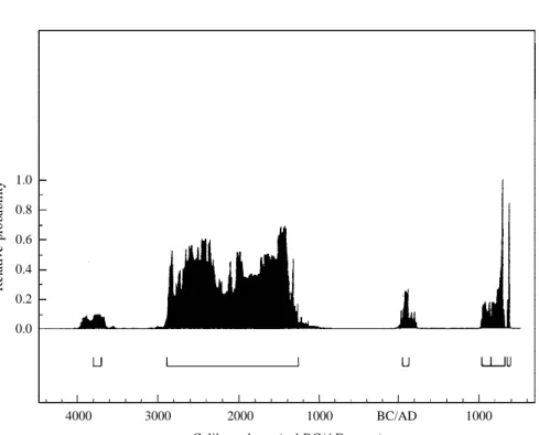
To obtain a view of the whole chronology of the site, the sum of probabilities of all the dates obtained is shown in Fig. 7. The sum of the probabilities of calibrated C14 dates is a frequently used method for obtaining the joint distribution of dates without reducing the margin of error. The calculated interval does not date a specific point in time, but generates the estimated time lapse for the period between the dates. Thus the interval obtained at 2 sigma should be understood as 95.4 % of the period that corresponds to the dates and not as 95.4 % of probabilities that all dates will be included in that interval (Bronk Ramsey, 1995; Caballero et al, 1999). In order to obtain this graph, the sum of probabilities method was used on the Oxcal programme, which yielded 6 intervals. The first, 3794-3705 cal BC, is no more than the reflection of date ICEN-882. The second shows the continuous occupation of the site during the 3rd and 2nd millennia BC, and we
can see the distribution of probabilities of the total number of dates in that period (2884--1289 cal BC). This distribution shows maxima and minima that should be understood as a greater or lesser probability that the moment is represented by the C14 dates. Thereafter, we have a small probability associated with the sample CSIC-1656 (54-135 cal AD). Finally, the last intervals show the medieval occupation of the site.
6. FINAL COMMENTS (S. O. J. & A. R.)
– Samples for C 14 dating were gathered according to the current method employed in archaeological excavations, which in fact ‘decontextualises’ the carbon to be dated (Hodder, I., 1999): that is to say, although the selected samples were found within layers, located three-dimensionally and joined to other structures or contexts, they were removed from the archaeological ‘complex’ in which they were originally inserted. This ‘complex’ also contains fragments of pottery, stone artifacts, fauna etc. Following Hodder on the nature of the archaeological process, we proceed in these cases by a method of truncation, which removes the possibility of making correlations that will eventually be important when the ‘archaeological contexts’ surrounding the samples in question are evaluated cri-tically.
– The relationship between the stratigraphic layer and the absolute chronology at Castelo Velho rests upon two types of constraint:
1. problems relating to processes of sedimentary alteration (of natural or man-made origin) that are not perceptible in the stratigraphic analysis of the contexts gathered for dating. Thus, some samples collected in layer 4 may be the result of ‘move-ments’ in prehistoric epochs, in which case the respective datings will reflect ‘intrusive moments’ corresponding to the chronology of the layers 3 and 2. 2. problems of methodology of C 14 dating, particularly those that lead to excessive
time intervals (hundreds of years), thereby preventing a detailed chronology which stipulates the possible limits of each layer.
– Stratigraphic analysis associated with carbon 14 analysis indicates continuous occupation at Castelo Velho between 3000 BC and c. 1300 BC.
– The analysis of C 14 dates from the site used new statistical techniques, such as the ‘sum of probabilities’ method, which allowed the absolute chronology to be refined and the problems inherent in the constraints described above to be overcome.
– The interpretation of the absolute chronology of Castelo Velho shows the importance of constant interaction between the archaeologist responsible for the excavation at the site and the laboratory that supplies the C 14 dates. Indeed, the absolute chronology must be integrated into a complete evaluative process which includes interpretation of the stratigraphy, of the type of associated materials and structures, and of chronologies (absolute and relative) for contemporary archaeological contexts. Analysis of C14 dates should take place within a global process of research, shared by all parties interested in the understanding of an archaeological site.
Porto – Madrid, February 2002
BIBLIOGRAPHY
ANTUNES, M. T. & E CUNHA, A. S. (1998), Restos humanos do Calcolítico – Idade do Bronze de Castelo Velho, Freixo de Numão, Vila Nova de Foz Côa – preliminary note, Côavisão, Cultura e Ciência, nº 0, pp. 35-42.
BRONK RAMSEY, C. (1995), Radiocarbon calibration and analysis of stratigraphy: the OxCal program, Radiocarbon, 37 (2), pp. 425-430.
CABALLERO, L., FERNÁNDEZ, M., RUBINOS, A., MACIAS, R., LÓPEZ, P., AR-NANZ, A. M., UZQUIANO, P. & GUARÁS, B. (1999), Notas sobre el complejo productivo de Melque (Toledo). Prospección del territorio y análisis de carbono – 14, polinicos, carpológios, antracológicos y de morteros, Archivo Español de Prehistoria, vol. 72 (179-180), pp. 199-240.
CABRAL, J. M. (1995), Prop. no. 1, 1º Congresso de Arqueologia Peninsular, vol. VI, Porto, SPAE, p. 512.
FIGUEIRAL, I. (1998), Castelo Velho (Freixo de Numão, Vila Nova de Foz Côa). Os restos vegetais carbonizados, Côavisão, Cultura e Ciência, nº 0, pp. 43-48. FIGUEIRAL, I. (1999), Castelo Velho (Freixo de Numão, Portugal). The ‘charcoalified’
plant remains and their significance, Journal of Iberian Archaeology, vol. 1, pp. 259-267.
HODDER, I. (1999), The Archaeological Process. An Introduction, Oxford, Blackwell. JORGE, S. O. (1986), Povoados da Pré-História Recente da Região de Chaves – Vila
Pouca de Aguiar, Porto, Instituto de Arqueologia da FLUP.
JORGE, S. O. (1993), O povoado de Castelo Velho (Freixo de Numão, Vila Nova de Foz Côa) no contexto da pré-história recente do Norte de Portugal, 1º Congresso de Arqueologia Peninsular, vol. I, Porto, SPAE, pp. 179-216.
JORGE, S. O. (1994), Colónias, fortificações, lugares monumentalizados. Trajectória das concepções sobre um tema do Calcolítico peninsular, Porto, Revista da Faculdade de
Letras, 2nd series, vol. XI, pp. 447-546.
JORGE, S. O. (1998), Castelo Velho de Freixo de Numão (Vila Nova de Foz Côa, Por-tugal): breve genealogia de uma interpretação, Estudos Pré-Históricos, vol. VI, pp. 279-293.
JORGE, S. O. (1999), Domesticar a terra. As primeiras comunidades agrárias em terri-tório português, Lisbon, Gradiva.
JORGE, S. O. (2001), Castelo Velho (Freixo de Numão, Vila Nova de Foz Côa, Portugal) et la problématique des “habitats fortifiés” de la Péninsule Ibérique, Communautés Villageoises du Proche-Orient à l’Atlantique (dir. J. Guilaine), Paris, Ed. Errance, pp. 241-252.
JORGE, S. O. (in press a), Etapas de estudo e valorização do sítio pré-histórico de Castelo Velho de Freixo de Numão, Vila Nova de Foz Côa, Portugal, Actas do Simpósio “Conservação e intervenção em sítios arqueológicos e monumentos históricos, Porto – Paredes de Coura, Univ. Portucalense Infante D. Henrique – Câmara de Paredes de Coura, April 2001.
JORGE, S. O. (in press b), Um vaso campaniforme cordado no Norte de Portugal: Castelo Velho de Freixo de Numão (Vª Nª de Foz Côa). Breve notícia, Porto, Revista do Departamento de Ciências e Técnicas do Património, vol. 1.
JORGE, S. O., OLIVEIRA, M. L. & S. A. E. GOMES, S. (1998/99), Uma estrutura ritual com ossos humanos no sítio pré-histórico de Castelo Velho de Freixo de Numão (Vila Nova de Foz Côa), Portugalia, Nova Série, vol. XIX-XX, pp. 29-70. JORGE, S. O. & Rubinos, A. (2002), Cronologia absoluta de Castelo Velho de Freixo de
Numão: os dados e os problemas, Côavisão, Ciência & Cultura, vol. 4, pp. 95-111. PEREIRA, L. S. (1999), As cerâmicas “Cogeces” de Castelo Velho, Freixo de Numão (Vila Nova de Foz Côa). Seu enquadramento peninsular. Porto, unpublished Masters dissertation in Prehistoric Archaeology presented to the Faculty of Letters of the University.
SANCHES, M. J. (1997), Pré-História Recente de Trás-os-Montes e Alto Douro, 2 vols., SPAE, “Textos”, vol. 1.
STUIVER, M., REIMER, P. J., BARD, E., BECK, W. J., BURR, G. S., HUGHEN, K. A., KROMER, B., MCCORMAC, G., VAN DER PLICHT, J. & SPURK, M. (1998), INTCAL 98. Radiocarbon age calibration, 24.000 – 0 cal BP, Radiocarbon, 40 (3), pp. 1041-1084.
Fig. 1 – Location of the site of Castelo Velho in the Iberian Peninsula. Fig. 2 – Schematic plan of the ‘monument’ of Castelo Velho at the second phase of
construction, after the archaeological campaign of 2000 (final drawing by V. Fonseca).
Fig. 3 – Schematic plan of the ‘monument’ of Castelo Velho at the second phase of
construction, after the archaeological campaign of 2000. Numbers refer to samples dated by C 14, shown in Tables 1 and 2 (final drawing by V. Fonseca and S. O. Jorge).
Fig. 4 – Carbon 14 dates according to the layer from which they were taken. Historic
dates not included. The column represented for each date corresponds to the total of intervals obtained in the calibration (see text).
Fig. 5 – Chronology of prehistoric dates of Castelo Velho.
Columns represent the same as in Fig. 4.
Fig. 6 – Chronology of medieval dates of Castelo Velho. Columns represent the same
as in Fig. 4. Fig. 4 Layer 2 Transition 2/3 Layer 3 Layer 4
Calibrated age (cal BC years) Calibrated age (cal BC years) Calibrated age (cal AD years)
Fig. 7 Relative probability Calibrated age (cal BC/AD years)
100
Susana Oliveira Jorge & Antonio RubinosAbsolute chronology of Castelo Velho de
Freixo de Numão: data and problems
101
102
Susana Oliveira Jorge & Antonio RubinosAbsolute chronology of Castelo Velho de
Freixo de Numão: data and problems
103
1.0 0.8 0.6 0.4 0.2 0.0 4000 3000 2000 1000 BC/AD 1000
Calibrated age (cal BC/AD years)
Fig. 7 – Sum of probabilities of the total C 14 dates calibrated at Castelo
Velho, using the Oxcal 3.5 programme, curve INTCAL 98, 2 sigma. Intervals obtained are: 3794-3705 cal BC (1,1%); 2884-1289 cal BC (82,5%); 54-135 cal AD (1,9%); 1037-1144 cal AD (1,9%);