IOP Conference Series: Materials Science and Engineering
PAPER • OPEN ACCESS
The city shaped through the railway line: Albergaria-a-Velha, Portugal
(1908-2018)
To cite this article: Bruno Sousa et al 2019 IOP Conf. Ser.: Mater. Sci. Eng. 603 042094
View the article online for updates and enhancements.
WMCAUS 2019
IOP Conf. Series: Materials Science and Engineering 603 (2019) 042094
IOP Publishing doi:10.1088/1757-899X/603/4/042094
The city shaped through the railway line: Albergaria-a-Velha,
Portugal (1908-2018)
Bruno Sousa1, Rita Ochoa2, Mafalda Sampayo3 1University of Beira Interior, Covilhã, Portugal
2CIAUD-UL/UBI, University of Beira Interior, Covilhã, Portugal 3CIES-IUL, University Institute of Lisbon, Portugal
mgts@iscte-iul.pt
Abstract. The construction of the railway lines in the cities has led to relevant territorial transformations and instigated the first urban planning operations all over the world. In Portugal, the deployment of the railway line — even though late in the second half of the 19th century — had a crucial role in the transformation of the territory. This article analyses the relationships between the implementation of the railways and the urban development. This is clarified with the case study of the city of Albergaria-a-Velha, in Portugal, which takes part in the largest railway system named “Vale do Vouga” line. The article is organized into three main moments. First, the implementation of the railways in the cities, in general, is addressed. Then, in a second moment, the implementation of the railways in Portugal is studied. Finally, the article focuses on the case of Albergaria-a-Velha and the way the railways relate to the urban development in this territory. It was found that, initially, the deployment of the train line in Albergaria-a-Velha was not too invasive in the territory, occupying predominantly agricultural lands. Also, it is noticed that Albergaria-a-Velha suffered its greatest urban growth during the early 70s of the 20th century. This came about abruptly and unregulated, similarly to what occurred in several other cities during this period. In the current urban structure, the railway line is an element that clearly divides the city. But still, over time, the railway line was responsible for moments in which the city was redesigned and adapted to it, through the new buildings and streets. In fact, the railway line had an important role in the regulation of the urban fabric, shaping and defining the urban growth in Albergaria-a-Velha. We conclude that the railway line produces two opposite effects in the urban design of Albergaria-a-Velha. It regulates the space, but acts simultaneously as a barrier. Not only it conditions the roads that it crosses, but also conditions the limits on the development of urban form, while not preventing the urban growth.
1. Introduction
This article develops and clarifies the relationship between railroad implementation and urban development, based on the case study of the city of Albergaria-a-Velha and its relationship with the Vouga valley railway line.
The methodology adopted in this study follows: i) the survey of documentation in historical archives (IMT, CIGeoE, DGT and Albergaria-a-Velha Municipal Council); ii) the analysis of cartography and projects for the railway line and the production of analytical drawings of the
WMCAUS 2019
IOP Conf. Series: Materials Science and Engineering 603 (2019) 042094
IOP Publishing doi:10.1088/1757-899X/603/4/042094
2
analytical drawings to study the relationship between the railway and urban development. In the analytical drawings referring to the evolution of the urban network, the following historical periods are selected for analysis: i) XVII century – corresponding to the first references to the urban fabric; ii) XIX century - corresponding to the appointment of Albergaria-a-Velha as the county seat; iii) 1st half of the XX century - implementation of the railway line and opening of new streets; iv) until 2018 - significant changes in the urban fabric, with the opening of the industrial zone, new streets and consequent bipolarization of the city.
2. City and railways
New industries developed in city centers of northern Europe with the appearance of the first railway lines by the end of the 18th century. London doubled its population in just one generation. Manchester grew at an accelerated rate, even in unsanitary conditions [1].
In the middle XVIII century, the liberal cities presented an urban network that was bounded, in many cases, by walls [2]. Railroad and industrial growth, associated with the lack of hygiene and habitability within cities, were the main causes of the breakdown of urban boundaries and the overthrow of the city walls [3]. Described by Mumford [4] as 'motorized propagation', the large urban sprawl that would radically change land use and the landscape of the time, owes its existence to the rail passenger transportation system [5].
The year 1830 was marked by the construction of the first major railway line between two of the largest industrial capitals of the time, Manchester and Birmingham. Subsequently, the railway network began to spread throughout the major European centers and superseded all other modes of transport, becoming one of the icons of the industrial revolution [6].
This new mode of transport also had an impact on the structuring of new housing estates outside the urban centers, the suburbs. Its linear configuration, capable of reaching a vast territory, also defined new centers with each new station built. The railways brought new possibilities for mobility, habitability, and business, both in the industry and in the real estate sectors, which leads to massive land valuation [7]. In 1840, the land was five times more expensive to expropriate in England compared to Germany and ten times more expensive than in America [8]. This would restrain the designs of the new railways and consequently the design of the public space itself.
The absence of urban planning practice and regulatory laws allowed railway builders to be limited only by geographical conditions, something that would change towards the end of the 19th century [9].
3. The railways in Portugal
On October 28, 1856, Portugal celebrated the construction of its first train line, 30 years after the England’s first. Synonymous with culture and technological advancement, this new mode of transport was the vehicle for the modernization of Portuguese mobility. Guaranteeing the transport of large volumes, the railway was welcomed not only by those who sought greater mobility, but also by national industries seeking internationalization. This leads to the quick expansion of the Portuguese railway network.
The construction of the railways was seen by the Portuguese leaderships as an opportunity to open the doors of Europe to a country that was until then geographically distant [10]. The Portuguese role in international networks was deemed to change, since there were intentions in Europe for a rail network that converged in Portugal benefiting from the existing maritime connections to the American continent.
WMCAUS 2019
IOP Conf. Series: Materials Science and Engineering 603 (2019) 042094
IOP Publishing doi:10.1088/1757-899X/603/4/042094
By the time the Portuguese and Spanish railways were built, the Iberian peninsula had just recently freed itself of the war against Napoleon’s armies. Perhaps driven by fears of new invasions, in 1844, the Spanish crown established the track gauge (distance between rails) as 6 Spanish feet (1674mm) for the Spanish railways. This decision condemned the Spanish trains to isolation from Europe that had adopted the track gauge of 1435mm. Portugal, which would start the construction of its first full lines (the East line and the South line) in the next decade, on the European track gauge, was obliged to change to a similar track gauge (5 Portuguese feet – 1664mm), as a consequence of good relations in the Iberian market [11] and its geographical tie in. Only in 1955, both governments settled on a uniform track gauge of 1668mm called the Iberian track gauge.
Isolated from central Europe, it was thus left to the two countries to structure a rail network that would reduce borders and distances between them. To this end, in 1866 a treaty of free transit of railways was signed and in 1868 the Lisbon–Madrid line, the first between the two countries, was inaugurated. Irregular topography, varied and difficult to overcome, poor cartography, along with the various economic crises that the country suffered, contributed to the fragility of the Portuguese railway network [12].
Although the railways contributed to connect several regions of Portugal, some territories remained isolated [13]. The construction of the Portuguese railways, which was not as large as it was late, demonstrates the inexperience of Portuguese engineers of the time, being one of the shortest railway networks in Europe [14] (table 1). The first holistic national plan for the railways was set up in 1877, when the railway network had already over 1000km. In fact, the main intention of the plan was clearly just to connect Lisbon to the North, to the South and to Spain, neglecting the remaining agglomerations [15].
Table 1. Comparative table of the growth of European railways [14]
year 1856 1880 1890 1900 1910 Portugal 36a 1 177 2 083 2 371 2 898 Spain 489 7 086 9 083 11 040 11 362 France 5 852 23 089 33 280 38 109 40 484 Germany 8 617 33 838 42 869 51 678 61 209 United Kingdom 12 318 25 060 27 827 30 079 32 184 Italy 1 360 9 290 13 629 16 429 18 090 a in Kilometers
4. Albergaria-a-Velha and the Vouga valley railway line
4.1. The territory occupation
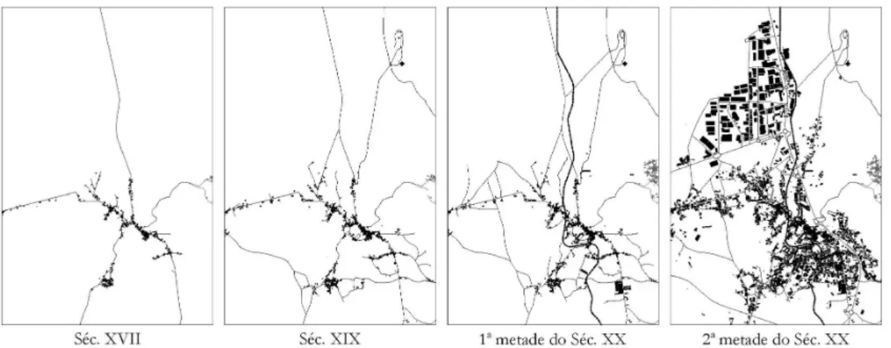
Framed by the Vouga River to the South and by the Caima River to the West, Albergaria-a-Velha maintained a strategic position during the use of river transportation. Until the 17th century and in terms of morphology, Albergaria-a-Velha consisted of a set of streets accessing to nearby the neighborhoods, setting up disperses urban fabric and without a definition of a specific center. This set of edifications has developed along the royal road, bringing local trade and more edification to this axe and growing through a branched structure (Figure 1) [16].
WMCAUS 2019
IOP Conf. Series: Materials Science and Engineering 603 (2019) 042094
IOP Publishing doi:10.1088/1757-899X/603/4/042094
4
Figure 1. Evolution of the urban cluster of Albergaria-a-Velha
Albergaria-a-Velha assumed a strategic position on the commercial changes of the time. Besides the royal road which linked Coimbra to Oporto, another important road passed in Albergaria, connecting Aveiro to Viseu (the current EN16). During the 19th century, some changes occurred in the territory, first with the construction of a chapel in Senhora do Socorro and its access road [17], then with the construction of the urban center, a project of the lieutenant Brito Rebelo, that modernized the city with new avenues and with the built in 1897 of the Town Municipality (Figure 1). In the first half of the 20th century, Albergaria suffered new territorial transformations, with the construction in 1910 of the Vouga valley railway line, which crossed the city by the center and configuring one of the most relevant facts to its urban development (Figure 1).
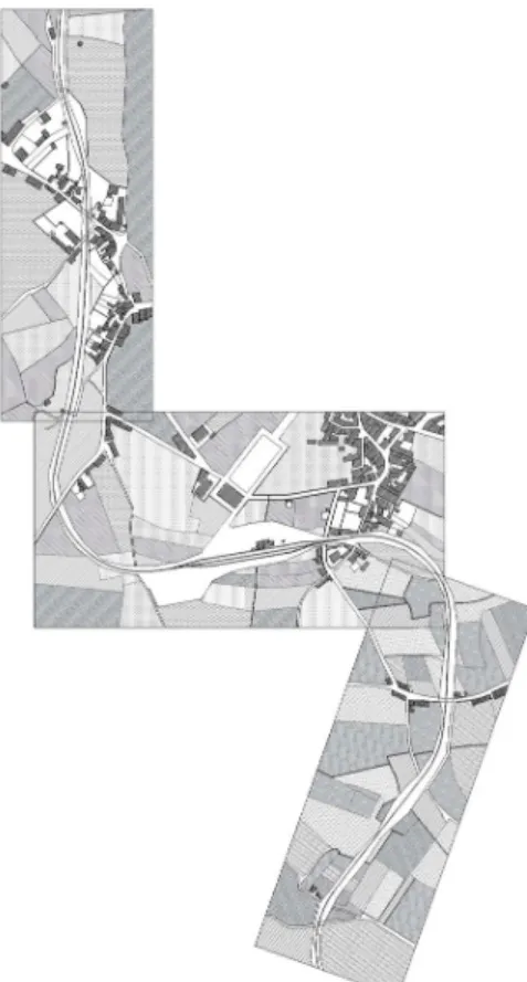
But the largest territorial transformation takes place in the second half of the 20th century with the construction of a new road, the “Variant” of Albergaria-a-Velha, surrounding the city to the East (Figure 1). This allowed the deviation of the national road to the limits of the town, freeing its central core of the movement originated by the circulation to outside. With the increasing population dynamics, new equipment was built, such as the Municipal Market in 1968 and the preparatory and high school during the 70s (currently the high school and the business incubator, built over the demolished Napoleon neighborhood). From these, the urbanization of both South and Southeast area of the city began, forming a new center next Fernando Pessoa square, setting up an area currently referred to the "New Paths". In 1983, it is inaugurated the industrial area to the North, originating the extension of the urban fabric to the limits of this area.
4.2. The relationships between the implementation of the railways and the urban development
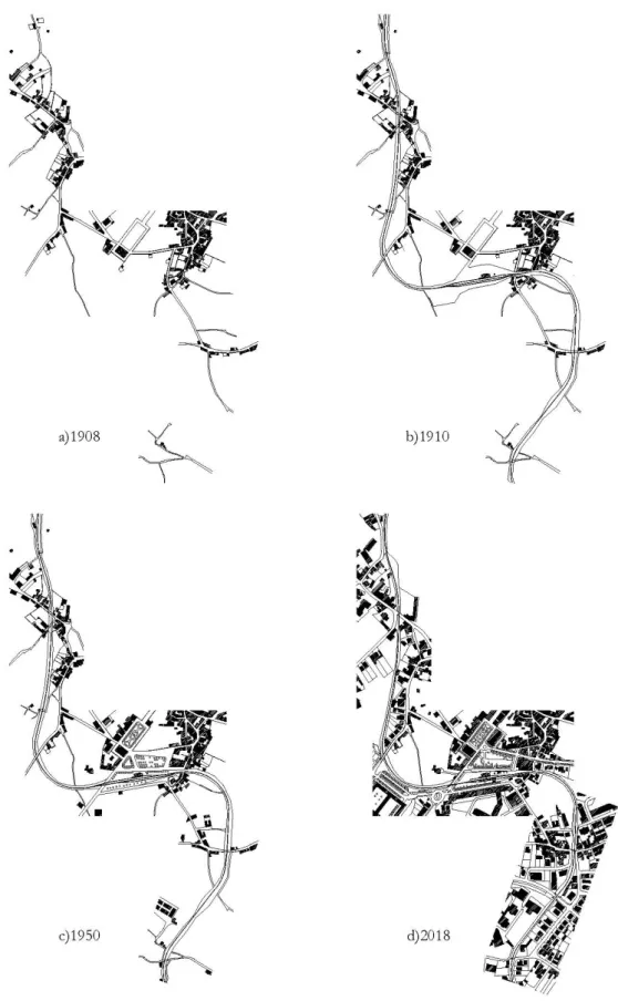
The interaction between the railways and the urban environment generates tensions which, while they have their origin in inadequate urban planning, affect both the railway and urban operation [18]. To understand the influence of the railway line in the drawing of the city, this chapter will analyze the cartography in four periods at the urban development of Albergaria-a-Velha (Figure 2): 1) 1908 (before the implementation of the railway line); 2) 1910 (after the construction of the railway line); 3) 1950; 4) 2018.
WMCAUS 2019
IOP Conf. Series: Materials Science and Engineering 603 (2019) 042094
IOP Publishing doi:10.1088/1757-899X/603/4/042094
Figure 2. Urban structure in Albergaria-a-Velha with the railway line in 1910
4.2.1. 1908 – Before the implementation of the railway line. In 1908, the city had a very dispersed
network and a poorly consolidated urban center (Figure 3a). Its denser zone corresponded to the oldest blocks in the historic area. Due to the activity of subsistence agriculture, a great part of the urban spaces was in rural areas.
4.2.2. 1910 – After the construction of the railway line. After the construction of the railway line, it is
possible to verify the impact that this infrastructure had on urban growth (Figure 3b). Considering the topography, the line followed the less rugged terrains, avoided the demolitions of the buildings and sought a proximity to the urban center. Also, the railway line surrounded the urban network to the South and given the vast area of agricultural land, imposed its design by expropriations [19] and sectioned the consolidated areas of the city. The Station is built near the Town Municipality and between both was built the Station’s street. In the area under analysis, the implementation of the railway line redirected and sectioned a total of eleven routes, which originated eight new level crossings along it.
WMCAUS 2019
IOP Conf. Series: Materials Science and Engineering 603 (2019) 042094
IOP Publishing doi:10.1088/1757-899X/603/4/042094
6
WMCAUS 2019
IOP Conf. Series: Materials Science and Engineering 603 (2019) 042094
IOP Publishing doi:10.1088/1757-899X/603/4/042094
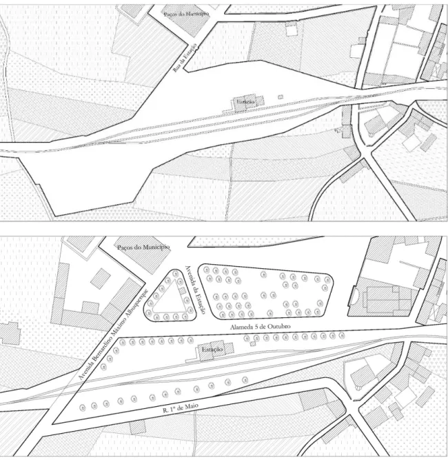
Until 1950, Albergaria-a-Velha had not a very strong urban growth (Figure 3c). Some new equipment was built during this period, namely the cultural building Cineteatro Alba, the Napoleão social neighborhood and the partial consolidation of the surrounding area of the Ferreira Tavares square in the urban center can be highlighted. The greater public space interventions were concentrated in the urban center and were the following: the reformulation of the Ferreira Tavares square; the Oliveira Salazar square; and the opening of new roads – Bernardino Máximo Albuquerque Avenue, 1º de Maio Street and Alameda 5 de Outubro. These urban interventions had a great impact on the Station’s area, limiting it and giving it the current design. This was the first time that a set of transformations occurred in the physical area of the railway line (Figure 4).
Figure 4. Configuration of the surrounding area to the station in the years of 1910 and 1950
Of those interventions, the one that stands out due to the urban design of the railway line was the intervention in the new Station Avenue that unites the building of the Town Municipality to the
WMCAUS 2019
IOP Conf. Series: Materials Science and Engineering 603 (2019) 042094
IOP Publishing doi:10.1088/1757-899X/603/4/042094
8
relationship between the parts (front of the station and municipality square), valuing the station. With the opening of Bernardino Máximo Albuquerque Avenue, it comes up one of the most traffic-grade level crossings in the city.
Observing the 2018 plant it is possible to notice a considerable transformation of the city. The opening of new schools and services in the 1970s encouraged the emergence of an urban concentration to the South and to the Southeast of the city. In this area, the urban form became denser and a new nucleus was formed, which adds the new services, the new commerce and a greater number of dwellings. The railway line cuts and divides the agglomerate, acting as a barrier (Figure 3d) [20]. However, the line didn’t prevent urban development and the buildings had developed attached to it. It is also noticeable the formation and the enlargements of several streets, whose design accompanies in many cases that of the railroad line. In this way, part of the road fabric presents a parallel with the railway line.
In the urban center, the roads formed during the first half of the 20th century played an important role in the formation of new roads and the expansion of the urban fabric. The limits imposed by these to the line allowed a larger area surrounding the station to be polarized. By the drawing of the public space, we can also realize that the importance of the station was decreasing with time; the Station Avenue was destroyed, being currently access to this one, through a secondary street.
Finally, it is possible to assume that the line assumes two opposite positions in the urban design, it is a regulator of the space, but produces a barrier effect. Not only in the conditioning of the roads it cross but also in the limits that form the development of the urban form. However, this does not prevent urban growth, as is visible in "New Paths", where the urban form grew over the boundaries of the line, forming points of tension between both.
5.
Conclusions
Throughout this article, it was found that, initially, the deployment of the train line in Albergaria-a-Velha was not too invasive in the territory, occupying predominantly agricultural lands. Also, it is noticed that Albergaria-a-Velha suffered from its greatest urban growth during the early 70s of the 20th century. This came about abruptly and unregulated, similarly to what occurred in several other cities during this period. In the current urban structure, the railway line is an element that clearly divides the city. But still, over time, the railway line was responsible for moments in which the city was redesigned and adapted to it, through the new buildings and streets. In fact, the railway line had an important role in the regulation of the urban fabric, shaping and defining the urban growth in Albergaria-a-Velha. We conclude that the railway line produces two opposite effects in the urban design of Albergaria-a-Velha. It regulates the space, but acts simultaneously as a barrier. Not only it conditions the roads that it crosses, but also conditions the limits on the development of the urban form, while not preventing the urban growth.
References
[1] L. Benevolo, “As origens da urbanística moderna,” Editorial Presença, Lisbon, 1981. [2] L. Benevolo, “A cidade e o arquitecto,” Edições 70, Lisbon, 1984.
[3] T. B. Salgueiro, “A cidade em Portugal: uma geografia urbana,” Afrontamento, Oporto, 1992. [4] L. Mumford, “A cidade na história: Suas origens, transformações e perspectivas,” Martins
Fontes, São Paulo, p. 544, 1982.
[5] B. Gravagnuolo, J. Calatrava, “Historia del urbanismo en Europa, 1750-1960,” Akal, Madrid, 1998.
[6] L. Mumford, “A cidade na história: Suas origens, transformações e perspectivas,” Martins Fontes, São Paulo, 1982.
WMCAUS 2019
IOP Conf. Series: Materials Science and Engineering 603 (2019) 042094
IOP Publishing doi:10.1088/1757-899X/603/4/042094
Fontes, São Paulo, 1982.
[8] L. Benevolo, “As origens da urbanística moderna,” Editorial Presença, Lisbon, 1981.
[9] L. Mumford, “A cidade na história: Suas origens, transformações e perspectivas,” Martins Fontes, São Paulo, 1982.
[10] M. Pinheiro, “Cidade e caminhos de ferro,” Centro de estudos de história contemporânea portuguesa, Lisbon, 2008.
[11] R. M. V. Alves, “Arquitectura, cidade e caminho de ferro: as transformações urbanas planeadas sob a influência dos caminhos de ferro,” PhD thesis, Faculdade de Ciências e Tecnologia da Universidade de Coimbra, Coimbra, 2015.
[12] R. M. V. Alves, “Arquitectura, cidade e caminho de ferro: as transformações urbanas planeadas sob a influência dos caminhos de ferro,” PhD thesis, Faculdade de Ciências e Tecnologia da Universidade de Coimbra, Coimbra, 2015.
[13] H. S. Pereira, “As Viagens Ferroviárias em Portugal (1845-1896),” CEM cultura e memória, ISSN 2182-1097-01, Vol. 1, pp 25-40, 2010.
[14] M. F. Alegria, “A organização dos transportes em Portugal (1850-1910): as vias e o tráfego,” Collection Memórias do centro de estudos geográficos, Centro de estudos geográficos, Lisbon, Vol. 12, 1990.
[15] L. E. da Silveira, D. Alves, N. M. Lima, A. Alcântara and J. Puig-Farré, “Caminhos de ferro, população e desigualdades territoriais em Portugal, 1801-1930,” Ler História, ISSN 0870-6182, Vol. 67, pp 7-37, 2011.
[16] B. D. N. Sousa, “Regeneração do Centro Urbano de Albergaria-a-Velha. Intervenção na Estação dos Caminhos de Ferro,” master thesis, Universidade da Beira Interior, Covilhã, 2018. [17] A. F. Pinho, “Albergaria-a-Velha e o seu concelho,” Tipografia Vouga, Albergaria-a-Velha,
1944.
[18] L. G. Santos and Fundación de los Ferrocarriles Españoles, “Urbanismo y ferrocarril: La construcción del espacio ferroviario en las ciudades medias españolas,” Fundación de los Ferrocarriles Españoles, Madrid, 2007.
[19] D. B. Ferreira, R. M. Vigário, “Albergaria-a-Velha 1910 – da Monarquia à República,” ADERAV, Aveiro, 2010.
[20] B. D. N. Sousa, “Regeneração do Centro Urbano de Albergaria-a-Velha. Intervenção na Estação dos Caminhos de Ferro,” master thesis, Universidade da Beira Interior, Covilhã, 2018.
![Table 1. Comparative table of the growth of European railways [14]](https://thumb-eu.123doks.com/thumbv2/123dok_br/18214867.876991/4.892.198.690.668.842/table-comparative-table-growth-european-railways.webp)