www.clim-past.net/8/1929/2012/ doi:10.5194/cp-8-1929-2012
© Author(s) 2012. CC Attribution 3.0 License.
of the Past
An independently dated 2000-yr volcanic record from Law Dome,
East Antarctica, including a new perspective on the dating of the
1450s CE eruption of Kuwae, Vanuatu
C. T. Plummer1,2, M. A. J. Curran2,3, T D. van Ommen2,3, S. O. Rasmussen4, A. D. Moy2,3, T. R. Vance2, H. B. Clausen4, B. M. Vinther4, and P. A. Mayewski5
1Institute for Marine and Antarctic Studies, University of Tasmania, Hobart, Australia
2Antarctic Climate and Ecosystems Cooperative Research Centre, University of Tasmania, Hobart, Australia 3Australian Antarctic Division, Kingston, Australia
4Centre for Ice and Climate, University of Copenhagen, Copenhagen, Denmark 5Climate Change Institute, University of Maine, Orono, ME, USA
Correspondence to:M. A. J. Curran ([email protected])
Received: 20 March 2012 – Published in Clim. Past Discuss.: 2 May 2012
Revised: 27 September 2012 – Accepted: 1 November 2012 – Published: 28 November 2012
Abstract.Volcanic eruptions are an important cause of nat-ural climate variability. In order to improve the accuracy of climate models, precise dating and magnitude of the climatic effects of past volcanism are necessary. Here we present a 2000-yr record of Southern Hemisphere volcanism recorded in ice cores from the high accumulation Law Dome site, East Antarctica. The ice cores were analysed for a suite of chemistry signals and are independently dated via annual layer counting, with 11 ambiguous years at 23 BCE, which has presently the lowest error of all published long Antarc-tic ice cores. Independently dated records are important to avoid circular dating where volcanic signatures are assigned a date from some external information rather than using the date it is found in the ice core. Forty-five volcanic events have been identified using the sulphate chemistry of the Law Dome record. The low dating error and comparison with the NGRIP (North Greenland Ice Core Project) volcanic records (on the GICC05 timescale) suggest Law Dome is the most accurately dated Antarctic volcanic dataset, which will im-prove the dating of individual volcanic events and potentially allow better correlation between ice core records, leading to improvements in global volcanic forcing datasets. One of the most important volcanic events of the last two millennia is the large 1450s CE event, usually assigned to the eruption of Kuwae, Vanuatu. In this study, we review the evidence sur-rounding the presently accepted date for this event, and make
the case that two separate eruptions have caused confusion in the assignment of this event. Volcanic sulphate deposition es-timates are important for modelling the climatic response to eruptions. The largest volcanic sulphate events in our record are dated at 1458 CE (Kuwae?, Vanuatu), 1257 and 422 CE (unidentified).
1 Introduction
Volcanic aerosols from major eruptions are transported through the stratosphere and deposited across the world, in-cluding high latitude polar areas. Ice cores retrieved from these areas offer an archived record that can be analyzed (e.g. measuring the electrical properties or sulphate content of the ice) for the unique signature of volcanic events pre-served within them. This information can be used to infer the potential climatic impact of an eruption, by calculating esti-mates of the total sulphate deposition to the ice sheet from a volcanic eruption, provided that events can be dated with sufficient accuracy.
Producing an accurately dated volcanic chronology re-quires a well-dated ice core timescale. The most accurately dated ice cores are dated using annual layer counting meth-ods (Cole-Dai et al., 1997) where seasonal variations in phys-ical or chemphys-ical properties marking each year in the ice are counted. However, this requires a high snowfall site to be able to resolve the annual layers; therefore this method can-not be applied at all sites. Where layer counting cancan-not be applied, ice core timescales are produced based on the iden-tification of reference horizons and assumptions about accu-mulation rates. This method is capable of producing a rea-sonably accurate timescale, but it is important to understand the limitations of, and implications of, the use of this “non-independent” method. Incorrect identification of and assign-ment of dates to reference horizons will cause errors in the timescale. Often it is difficult to obtain reliable dates for reference horizons beyond recent history, especially in the Southern Hemisphere (SH), as historical documentation of eruptions is poor. The dating accuracy is compromised by variations in snowfall from the average. It is crucial to avoid circular arguments whereby volcanic signatures in ice core records are assigned a date based on some external informa-tion (e.g. historical documents, tree ring records, and other ice cores) and then used to verify the dating of that particular event. The assignment of dates does not advance the dating accuracy of the volcanic record – the record will only be as accurate as the record it has been synchronized to, and has the potential to inadvertently reinforce the acceptance of an initially questionable date. Cores dated by non-independent methods remain essential to understanding the spatial distri-bution patterns of volcanic sulphate aerosols, and dating of deep ice where layer counting cannot be reliably performed. Ice cores dated via accurate layer counting, independent of previously reported volcanic event dates – such as Law Dome – are key to producing high accuracy volcanic chronologies, and improving the dating of events recorded during the first millennium CE, which offers the opportunity to improve cor-relations between ice cores, as well as better constraining the timing of past volcanic eruptions.
The timing of eruptions is an important factor in produc-ing global volcanic forcproduc-ing estimates. Presently there are two primary datasets (Crowley et al., 2008; Gao et al., 2008). The Gao dataset places the large, global volcanic horizon of the 1450s at 1453 CE, with a smaller event classified as Northern
Hemisphere (NH) only later in that decade (all dates in this work are CE unless stated otherwise). The Crowley dataset has NH event beginning in 1451, and a second event start-ing in mid-1459, and one SH event startstart-ing in 1456. Like Gao, the Crowley study defined the late-1450s volcanic event as NH-only, but suggest the eruption history during this pe-riod warrants further investigation (Crowley and Unterman, 2012). Owing to the size of this event, the timing of the event is of importance to climate reconstructions, and we use the accurate, independently dated Law Dome volcanic record to explore the timing of this important event.
DSS (Dome Summit South) is a coastal site, and the chem-istry record is influenced by marine aerosols. The site has a high annual accumulation (0.70 m yr−1 ice equivalent), rel-atively low mean surface temperatures (−21.8◦C) and wind speeds (8.3 m s−1) (Morgan et al., 1997). Precipitation events
at Law Dome occur on average with sufficient frequency to preserve signals at monthly resolution (McMorrow et al., 2001). This allows for high-resolution sampling and this study provides an independently dated, seasonally resolved trace chemistry record spanning the past 2000 yr.
2 Dating and chemical analysis
The Law Dome record was independently dated using annual layer counting of a suite of chemistry species with seasonally defined behaviours. These include oxygen isotopes (δ18O), deuterium (δD), hydrogen peroxide (H2O2) non-sea-salt
sul-phate (nssSO24−) and sea salt species (Cl−, Na+and Mg2+). Additionally, the ratio of SO24−/Cl− was used as a summer marker. Ice core sampling and analysis methods used were described by Palmer et al. (2001) and Roberts et al. (2009). At 23 BCE, annual layer thickness is reduced to 0.25 m yr−1 ice equivalent as a result of layer thinning due to ice flow. At this depth, trace ion chemistry was sampled at 2.5 cm resolu-tion, allowing for 8 to 10 samples per year, which is sufficient for annual dating. Analysis ofδ18O was conducted at 1 cm resolution. Following the methods of Morgan and van Om-men (1997), the summer maxima inδ18O were fixed as 1 Jan-uary of each year horizon. Whereδ18O was unavailable, the
δD or nssSO24− maximum was used. Dating of the discrete samples was performed using linear interpolation between year depth horizons.
0 0.5 1 1.5 2 2.5 3
-50 150 350 550 750 950 1150 1350 1550 1750 1950
Conc
ent
ra
ti
on (
µ
E
q/
L
)
Year (CE) Residual non sea-salt sulphate (2-yr smooth)
422 CE
, unknow
n (3)
1257 CE
, unknow
n (2)
1275 CE
, unknow
n (5)
1458 CE
, K
uw
ae
? (1)
1815 CE
, T
am
bora
(4)
Fig. 1.The Law Dome residual non-sea-salt sulphate record.The peaks shaded in grey represent the five highest event fluxes, with the number in brackets signifying event size rank in the Law Dome record (1 being the highest). A 2-yr smooth was used for illustrative purposes.
DSS0809 and DSS0910, respectively) to bring the record up to 2009. Palmer et al. (2001) produced a single chemistry time series from DSS99, DSS97 and DSS down to 400 m (1300), and we have applied their methods to extend the Law Dome chemistry record from 1995 to 2009. All cores used were dated via annual layer counting. Dating is registered across core boundaries by matching seasonal features in oxy-gen isotopes and other chemistry species through the periods of overlap between cores. Dating across core boundaries is unambiguous and locked without error. In the event of mis-alignment of overlapping records, natural variability in ac-cumulation from year to year would result in rapid loss of coherence between annual cycles.
Layer counting identified 11 ambiguous years where the seasonality was not clear. Of these 11 yr, 7 yr were not counted where evidence for a year was weak, but could not be conclusively discounted. Four years were counted where multiple lines of evidence supported a year. This error esti-mation technique allows the date at 23 BCE to be a maxi-mum of 7 yr older or 4 yr younger than dated, with the record dated unambiguously to 1807, and±1 yr to 894. This error estimate is the lowest of all comparable-length Antarctic ice core records, with DML (Dronning Maud Land)±23 yr at 186 (Traufetter et al., 2004) and South Pole±20 at 176 (Fer-ris et al., 2011). Eruption dates previously published for Law Dome (Palmer et al., 2001) older than 1818 have been ad-justed for a 1-yr dating error due to a damaged section of core. This adjustment was made after synchronizing theδ18O of a new mid-length core retrieved from the DSS site in 2005 to the existing DSS main ice core across the period in ques-tion.
3 Determination of volcanic signals
There are three primary sources of sulphate to the Antarc-tic continent: sea salt, biogenic and volcanic sulphate, with anthropogenic sources considered minimal (Curran et al., 1998). To identify the signal associated with volcanic erup-tions, it is necessary to remove the sea-salt and biogenic sul-phate components from the total sulsul-phate concentration. We removed the sea-salt sulphate component by calculation of the non-sea-salt sulphate (nssSO24−)parameter, using Eq. (1).
nssSO24−= [total SO24−] −(0.1201−r)· [Na+] (1) where 0.1201 is the ratio of SO24− to Na+in seawater, and
ris a fractionation correction of 0.033 (Palmer at al., 2002) to account for sulphate depletion from the formation of frost flowers on sea ice (Rankin, et al., 2000). The nssSO24−signal at Law Dome is dominated by strong seasonality associated with the biogenic sulphate cycle. This biogenic signal has a local summer maximum, and winter minimum, and this sea-sonality can be a barrier to resolving the onset and duration of volcanic signals. To remove the biogenic signal, we cal-culated the residual nssSO24− ([nssSO24−]residual), shown in
Large volcanic events already identified in the record were removed prior to calculation of the residual to avoid incor-rectly weighting the ensemble, which would lead to an over-estimation of background sulphate concentrations.
Volcanic signals are detected as a rise above background levels (e.g. Moore et al., 1991; Delmas et al., 1992; Lang-way et al., 1995; Cole-Dai et al., 2000; Palmer et al., 2001; Traufetter et al., 2004; Ferris et al., 2011); therefore, we have identified volcanic signatures from the [nssSO24−]residualtime
series, where values above zero are representative of concen-trations above the 31-yr average. This method of volcanic determination is based on the method of Palmer et al. (2001), and uses visual classification criteria and knowledge of the sulphate seasonal cycle to discriminate between noise and volcanic signals. To be classified as volcanic, spikes in the residual record must be at least 6 months in duration. Devi-ations above the average during winter are characteristic of volcanic events at Law Dome as the variable biogenic sul-phate source is low, and winter sea-salt sulsul-phate contribu-tions can be accurately determined from the seawater ratio of directly measurable sea-salt species (e.g. Na+). Because bio-genic sulphate sources are more variable, residual sulphate peaks in summer only were treated with caution. Volcanic events have a clearly definable peak, and are characterised by a sharp rise in concentration at the onset of the volcanic event and then taper off. This conservative approach to iden-tification has a bias towards medium and large events, which are most clearly identifiable in our record, and we consider such events to be those most likely to have the greatest im-pact on climate.
Estimates of volcanic sulphate provide information on the climatic effects of volcanic eruptions as the amount of sulfur-rich gas emitted by eruptions can have an effect on global temperatures. The volcanic flux deposition estimates for Law Dome (Table 2) are calculated from the residual nssSO24− record according to Eq. (2).
fs= [nssSO24−]residual·ρ·l·10−3kg km−2 (2)
where [nssSO24−]residual is the residual nssSO24−in µg kg−1, ρ=917 kg m−3 – the density of ice, and l is the surface equivalent ice length of each sample (in metres) and corrects for the smaller apparent sample fluxes due to thinning of the ice with increasing depth. We report total volcanic deposition derived by summing the individual sample fluxes to give a to-tal deposition for the duration of the event. Law Dome depo-sition estimates from this study are∼25 % lower than those discussed previously for Law Dome by Palmer et al. (2002). The differences result from the residual calculation method used and small improvements in Law Dome flow thinning calculations (used in the calculation ofl) and fractionation corrections (r in Eq. 1). We note that our lower deposition for the Tambora, Indonesia, eruption (57.2 kg SO24−km−2) compares closely to the SH average of 51 kg SO24−km−2
as determined by Gao et al. (2007). Table 2 includes sul-phate depositional information from the NGRIP ice core for inter-hemispheric volcanic events. The calculation methods for the NGRIP depositional information can be found in Ap-pendix A. Because of the variability inherent in site-specific properties (e.g. sulphate depositional regime, accumulation from year to year, aerosol transport pathways), the deposi-tional size of an eruption can vary from site to site. There-fore, it is important to use as many records as possible when producing volcanic forcing estimates, provided that those records are dated with sufficient accuracy to resolve the same event across cores.
4 Volcanic eruption dating
Atmospheric transport of volcanic aerosols from eruption site to deposition site results in a time delay of typically 6 months to 1 yr, and is dependent upon eruption location, atmospheric circulation patterns and site precipitation char-acteristics. Estimates of this time delay are made by com-paring the onset of the volcanic signal in a dated ice core record to the eruption date of well-documented eruptions (e.g. Tambora, Krakatau). At Law Dome, the average delay is 1 yr (1σ=0.58 yr,N=11). The shortest delay of 0.6 yr was associated with the 1815 eruption of Tambora, Indonesia, and the longest delay observed was 2.5 yr for the 1982 eruption of El Chich´on. Palmer et al. (2001) suggested unusual at-mospheric patterns associated with the quasi-biennial oscil-lation could be responsible for this extended delay. 1982–83 period corresponds with a strong El Ni˜no-Southern Oscil-lation event that produced anomalous atmospheric circula-tion patterns over high southern latitudes (Houseago et al., 1998). Those anomalies could have affected the transport of volcanic aerosols following the El Chich´on eruption.
5 Results and discussion
Forty-five volcanic events have been identified in the Law Dome record between 1995 CE and 23 BCE. Based on total deposition, the largest volcanic events observed in our record are the 1458 (Kuwae?), 1257, 422 (Unidentified) and 1815 (Tambora) events. The sulphate deposition of the 1458 and 1257 eruptions was similar in size, approximately 1.8 times greater than the Tambora eruption. The 422 event signature is observed over a period of 4.3 yr, making it the longest event in our 2000-yr record, and also appears bimodal in nature and may be a result of two separate eruptions in close temporal proximity.
Table 1.Comparisons of the Law Dome volcanic event start dates with other independently dated records.
Volcanic Event Law Dome ice date NGRIP1 DML2 South Pole3 NH tree ring signature4
Pinatubo/Cerro Hudson 1991.7 1992 1992 1991 –
El Chich´on 1984.5 – 1982 – –
Agung 1964.1 – 1964 1963 1965
Tarawera 1887.5 – 1886 – –
Krakatau 1884.5 1884 1884 1887 1884
Cosig/”uina 1836.7 1835 1835 1836 1836
Galunggung 1823.4 – – – –
Tambora 1815.8 1816 1816 1815 –
Unidentified 1809.7 1809 1809 1808 1809
Unidentified 1695.3±1 1694 1695 1687 –
Gamkonora 1674.3±1 – 1676 1668 1675
Parker 1641.8±1 1641 1640 1634 1641
Huaynaputina 1600.7±1 1601 1601 1600 1601, 1602
Ruiz 1596.7±1 – 1596 1594 1596
Raung 1595.5±1 – – – –
Kelut 1587.3±1 1586 – – –
Billy Mitchell 1583.6±1 1584 – – –
Kuwae? 1458.5±1 1458 – – 1457, 1458–62
Kuwae? – 1453 1453 1453 1453
Unidentified 1344.0±1 1344 1343 1334 1342
Unidentified 1275.6±1 1276 1276 1274 1275, 1277
Unidentified 1268.4±1 – 1268 1269 –
Unidentified 1257.4±1 1259 1256 1260 1257
Unidentified 1229.2±1 1230 1227 1235 1230
Unidentified 1170.7±1 1168 1168 1176 1171
Unidentified 1014.6±1 – – – 1015
Unidentified 956.8±1 – 961 959
Unidentified 924.5±1 – – – –
Unidentified 900.5±1 897 – 908 900–903
Unidentified 679.2−4/+1 – – – 681
Unidentified 676.5−4/+1 675 685 662 674
Unidentified 566.3−5/+1 567 578 560 569
Unidentified 530.9−5/+1 533 542 531 532
Unidentified 449.7−6/+2 – 446 451
Unidentified 422.7−6/+2 425 441 411 421
Unidentified 343.7−6/+2 – – – 344
Unidentified 295.4−7/+3 297 315 288 –
Unidentified 258.7−7/+3 258 – – –
Taupo? ∼229−7/+3 230 249 217 230
Unidentified 198.4−7/+3 – – 181 –
Unknown 163.8−7/+3 186 –
Unknown 136.4−7/+3 137
Unknown 117.5−7/+4 119
Unknown 52.5−7/+4 –
Unknown −2.5−7/+4 –
All dates CE, and represent the date the volcanic signal is found in each core.
1See Appendix A for dating methods. 2Traufetter et al. (2004).
3Ferris et al. (2011).
4Salzer and Hughes (2007), tree ring growth minima (plain text) and and frost damaged rings (italics).
Table 2.Volcanic sulphate deposition at Law Dome. For events identified as inter-hemispheric, NGRIP depositional data are provided also.
Law Dome NGRIP
Event Start End Deposition Start End Deposition
Date Date (kg SO4km−2) Date Date (kg SO4km−2)
Pinatubo/Cerro Hudson 1991.7 1993.9 19.1±0.8 1992.1 1992.4 5.5±1.9
El Chich´on 1984.5 1984.8 <5.0 – – –
Agung 1964.1 1965.2 10.1±0.5 – – –
Tarawera 1887.5 1888.2 7.8±0.5 – – –
Krakatau 1884.5 1885.9 16.8±0.7 1883.5 1886.2 15.4±2.7
Cosig¨uina 1836.7 1837.8 8.7±0.5 1835.3 1838.4 33.4±2.1
Galunggung 1823.4 1823.9 6.1±0.9 – – –
Tambora 1815.8 1819.3 57.2±1.5 1816.1 1817.9 40.3±1.8
Unidentified 1809.7 1811.1 24.6±1.3 1809.3 1811.8 38.6±2.2 Unidentified 1695.3 1697.2 28.2±1.3 1694.1 1698.0 37.2±2.1
Gamkonora 1674.3 1676.0 14.7±0.5 – – –
Parker 1641.8 1643.3 21.3±0.8 1640.9 1643.6 41.6±3.0
Huaynaputina 1600.7 ∗ ∗ 1601.1 1603.7 48.0±2.4
Ruiz 1596.7 1598.4 18.8±1.6 – – –
Raung 1595.5 1596.1 <5.0 – – –
Kelut 1587.3 1588.3 7.9±0.7 1586.0 1586.6 5.4±1.1
Billy Mitchell 1583.6 1584.1 <5.0 1583.5 1583.7 2.8±0.7
Kuwae? 1458.5 1461.1 106.3±4.0 1459.2 1461.4 41.4±1.8
Kuwae? – – – 1453.2 1455.2 27.99±1.8
Unidentified 1344.0 1346.2 24.6±1.0 1344.9 1347.7 33.3±2.4
Unidentified 1275.6 1278.0 55.5±1.4 1277.3 1278.5 8.6±1.4
Unidentified 1268.4 1269.4 32.3±2.6 – – –
Unidentified 1257.4 1259.2 101.1±4.3 1258.1 1261.8 98.6±2.2 Unidentified 1229.2 1231.1 26.9±1.0 1229.5 1232.7 61.3±3.0 Unidentified 1170.7 1171.9 14.5±0.5 1167.4 1170.4 36.5±1.8
Unidentified 1014.6 1015.9 11.0±0.9 – – –
Unidentified 956.8 958.0 15.5±1.1 – – –
Unidentified 924.5 925.4 11.8±0.8 – – –
Unidentified 900.5 901.1 15.2±0.9 – – –
Unidentified 679.2 681.1 19.4±0.9 – – –
Unidentified 676.5 677.7 29.8±2.0 674.2 676.7 31.1±2.5
Unidentified 566.3 567.7 25.2±1.5 566.9 569.4 42.9±2.5
Unidentified 530.9 533.2 37.0±1.9 532.1 536.5 56.2±3.7
Unidentified 449.7 452.3 27.9±1.7 – – –
Unidentified∗∗ 422.7 427.0 63.1±1.6 425.1 426.9 17.5±1.5
Unidentified 343.7 345.2 16.0±1.3 – – –
Unidentified 295.4 297.0 27.6±1.6 297.1 297.7 8.9±1.3
Unidentified 258.7 260.0 24.5±1.6 258.1 262.1 55.4±2.9
Taupo? ∼229 232.3 ∗ 230.1 231.6 10.8±2.0
Unidentified 198.4 200.0 17.1±0.7 – – –
Unidentified 163.8 164.9 29.9±2.5
Unknown 136.4 137.0 13.2±1.4
Unknown 117.5 119.3 12.7±0.8
Unknown 52.5 54.1 14.4±0.6
Unknown −2.5 1.3 19.5±1.5
All dates CE.
∗Eruption signature incomplete. ∗∗Possibly two close eruptions.
when coupled with the variable biogenic sulphate back-ground. The attribution of eruption sources to sulphate spikes in the 695-yr period 1995–1300 (Table 1) was discussed in detail by Palmer et al. (2001). We have not attributed a source to any other volcanic signatures in this record apart from the 229 event. Although the start date of this event is not clearly identifiable due to a gap in the sulphate record be-tween 229 and 230, there is an increase in [nssSO24−]residual
values during 230/31. We suggest this event may be the ma-jor Holocene eruption of Taupo, New Zealand, on the evi-dence presented in this study, and dendrochronological work by Hogg et al. (2011) placing the date of this eruption at 232±5.
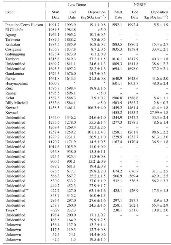
We have compared the Law Dome volcanic record to three other independent, annually dated ice core records in Table 1: NGRIP (Greenland) on the GICC05 timescale, Dronning Maud Land (DML) (Traufetter et al., 2004) and South Pole (SP04C5) (Ferris et al., 2011). We considered the GISP2 (Greenland) volcanic record and will discuss the record where relevant; however, we found the chronology to be less well resolved compared to NGRIP on the GICC05 timescale. The GICC05 timescale is derived from three, well-dated, independent Greenland records (NGRIP, DYE-3 and GRIP), and are layer counted through our period of interest (Vinther et al., 2006). Of the three Greenland cores in the GICC05 timescale, only NGRIP has sulphate data through our period of interest, and was used by Gao et al. (2008) in 1-yr resolution as part of their global volcanic forcing recon-struction. Here the NGRIP SO24− data are used in full res-olution (see Appendix A). The three cores compared in this work were chosen as they represent the most accurately dated ice core records of comparable length to Law Dome. Vol-canic events identified in each record were matched based on their eruption signature characteristics (e.g. signature shape, magnitude). Figure 2 illustrates the number of years of dif-ference between the dates of events in Law Dome and the 3 other ice cores. Comparisons with NGRIP show good agree-ment, averaging a 1-yr difference, with a maximum of 3.3 yr difference between volcanic deposition dates over the past 1800 yr. The agreement between Law Dome and DML for the period 2000–1000 CE is good, with the exception being the 1450s eruption attributed to Kuwae (discussed below). The two records do not agree as closely from 1000–172 CE, with the DML record drifting gradually to be 22 yr younger than Law Dome at the 164 (Law Dome) event. Comparisons of the Law Dome and South Pole records show the South Pole record to be more variable, drifting 10 yr younger than Law Dome, before coming back into agreement for the 531 event, and drifting to become 17 yr older than Law Dome by the 164 event. The 531 event signature is a distinct horizon across the three SH ice core records; therefore we are confi-dent in our matching of this event. The error in the SP045C timescale at this event is±15 yr; therefore synchronicity with Law Dome is permissible and not outside the timescale error bounds. NGRIP has two eruptions in close proximity (529
-25 -20 -15 -10 -5 0 5 10 15 20 25
100 300 500 700 900 1100 1300 1500 1700 1900
Y
ea
rs
of di
ffe
re
nc
e re
la
ti
ve
t
o L
aw
D
om
e
Year (CE)
NGRIP DML South Pole
Fig. 2.Comparison of Law Dome to other ice core volcanic records. Figure 2 illustrates the number of years of difference between the dating of volcanic events common to the NGRIP, DML and South Pole (SP045C) ice cores relative to Law Dome. Volcanic event dates have been matched on eruption signature. Squares indicate vol-canic event dates. DML and South Pole cores are from relatively low accumulation sites (0.073 and 0.075 m yr−1ice equivalent re-spectively), which may be a factor in the variability and drifting of those timescales relative to Law Dome (0.70 m yr−1ice equiva-lent). NGRIP at (0.19 m yr−1ice equivalent) still agrees well with Law Dome.
and 533). The 529 event has the larger sulphate deposition of the two, and has been linked to the eruption of Haruna, Japan (Soda, 1996; Larsen et al., 2008); therefore we have matched our record with the 533 eruption.
The accumulation rate of DML (0.073 m yr−1ice
equiva-lent; Schwander, 2003) and SP045C (0.075 m yr−1ice
equiv-alent; Ferris et al., 2011) is considerably lower than the 0.19 m yr−1 ice equivalent of NGRIP (Vinther et al., 2006) and 0.70 m yr−1ice equivalent of Law Dome (Morgan et al., 1997). The relatively low accumulation rates at the DML and SP045C sites may increase the chances of a seasonal cycle being absent or ambiguous in nature, thus contributing to the larger error estimates for these cores relative to Law Dome and NGRIP, and may be responsible for the gradual drift in dates relative to Law Dome and NGRIP.
Greenland GICC05 dates. The South Pole (SP04C5) ice core (Ferris et al., 2011) has an event dated 560 with an error of 2 %, which also places it within agreement of the NH dat-ing for this eruption, and it is likely the same event in all four ice cores. The distinct volcanic horizon dated late 530 at Law Dome is in close agreement with the 533 NGRIP date for this event. There is also a volcanic event dated 531 in the SP04C5 ice core, which is likely to be the same event. The 533 and 567 CE volcanic events cannot be resolved by the GISP2 core as no measurements are available through this time period, possibly due to damaged core sections. By con-firming the Larsen et al. (2008) interpretation that these three events were global, the forcing associated with these events can be more accurately represented.
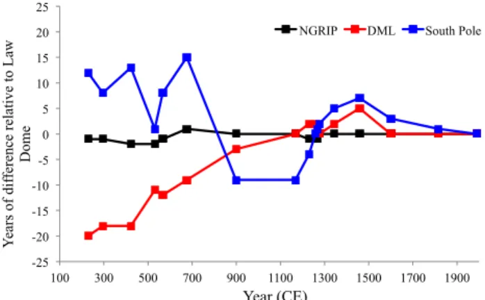
6 Dating of the major 1450s CE eruption
The largest sulphate spike observed in our 2000-yr record is an eruption with a deposition date commencing in mid-1458, and a total deposition of 106.3 kg·SO24−km−2, over 2.6 yr. Numerous ice core records have recorded a large volcanic signature during the 1450s (e.g. Langway, 1995; Moore et al., 1991; Delmas et al., 1992; Cole-Dai et al., 1997; Clausen et al., 1997; Ferris et al., 2011). Tree ring evidence for cool-ing, inferred from growth anomalies, has also been observed (e.g. LaMarche and Hirchboek, 1984; Briffa et al., 1998; Salzer and Hughes, 2007). These signatures have been linked with the eruption of the Kuwae caldera, Vanuatu. Histori-cal records of unusual weather phenomena through this pe-riod also provide further evidence for an eruption during the 1450s (Pang, 1993). Because this event is one of the largest in the last two millennia, it is important to constrain the tim-ing of the event so that its effect on the climate is correctly represented in global climate models.
Despite the magnitude of this event, the dating remains un-certain. Gao et al. (2006) attempted to constrain the dating by averaging the event date from multiple ice core records, con-cluding that Kuwae likely erupted in either 1452 or 1453. Gao et al. (2006) used 33 ice core records to arrive at a date for the Kuwae eruption signature; however, 14 of the 33 records used (Table 1; Gao et al., 2006) do not extend to 1450. Eleven of the remaining 19 records are not independent layer counted records. Dating is crucial in the case of this event, as it is necessary for the ice core timescale to be suffi-ciently accurate to resolve – in ice core terms – a very small time frame of 4–5 yr. Layer counted records are considered more accurate than those dated using depth-accumulation es-timate methods, however, require a sample resolution of 5–8 samples per year to resolve the years with confidence (Cole-Dai et al., 1997). Independence of these records is important – records that assign the date of Kuwae from some exter-nal information (e.g. Talos Dome (Stenni et al., 2001) and Plateau Remote (Cole-Dai et al., 2000)) could bias the end re-sult when producing a mean date from all available ice cores.
Taking the above into account, 8 cores of the origi-nal 33 used remain, including Law Dome (Palmer et al., 2001). The GRIP core has no volcanic signal detected be-tween 1445 and 1465 CE (Gao et al., 2006). Six ice cores – NGRIP (1458±1), GISP2 (1460±2; Zielinski, 1995), DYE-3 (1457±2)(Clausen et al., 1997) and Crˆete (1458±2) (Hammer et al., 1980) (NH) and Siple Station (1454±3) (Cole-Dai et al., 1997) and DML B32 (1453±5) (Traufet-ter et al., 2004) (SH) – all have a volcanic signal that falls within the error estimate of the Law Dome date of 1458±1. Traufetter et al. (2004) attributed the large sulphate peak present in the DML B32 core at 1453, to Kuwae; however, Ruth et al. (2007), during synchronization of EPICA Dome C (EDC) core to the DML B32 timescale using volcanic markers, used the ice date 1458 for that volcanic signature, a weighted average of the Law Dome (Palmer et al., 2001) and the DML B32 (Traufetter et al., 2004) dating, suggesting some reservation about the DML B32 dating of this event.
Our layer-counted dating places this large event at 1458±1, and when considering the uncertainties with dat-ing errors, the longest transport delay with precedent (2.5 yr), the earliest eruption date based on this work is 1455. Com-parisons of Law Dome and other layer-counted SH records – DML, Siple Station (Cole-Dai et al., 1997) and SP04C5 (Ferris et al., 2011) – yield deposition dates for the large sul-phate peak of 1453±5 in DML, 1454±3 at Siple Station and 1453±7 in SP04C5. This allows for a maximum date range of 1448 to 1458, 1451 to 1457 and 1446 to 1460, re-spectively. The higher accumulation rate and larger suite of measured chemistry available at Law Dome in comparison to the other SH records allows for better constrained error, giving a deposition date range of between 1457 and 1459. By comparing errors in the records, the common time period for this event deposition is between 1457 and 1459, with the eruption between 1456 and 1458, assuming the average lag time of 1 yr.
0.0 2.0 4.0 6.0
1450 1451 1452 1453 1454 1455 1456 1457 1458 1459 1460 1461 1462 1463
V
ol
ca
ni
c s
ul
fa
te
(kg
S
O4
-2
km
-2)
Year (CE)
Law Dome
0.0 5.0 10.0
V
ol
ca
ni
c s
ul
fa
te
(kg
S
O4
-2
km
-2)
NGRIP
Fig. 3.The Law Dome and NGRIP volcanic sulphate records between 1450–1460. The two distinct volcanic peaks in NGRIP are dated 1453 and 1458 CE; the single clear peak in Law Dome is dated 1458 CE. The two NGRIP peaks are evidence of two separate volcanic eruptions during the 1450s CE.
record to that of Salzer and Hughes (2007; Table 1). Salzer and Hughes used statistical methods to show ring-width min-ima years can be matched with known volcanoes or ice-core volcanic signals in 44 of 51 cases (86 %) for the last millen-nium in their record. The link between the 1452/53 NH tree ring anomalies and the large 1450s volcanic signal in SH ice cores, now attributed to Kuwae, appears to have come from the South Pole (PS1) ice core (Delmas et al., 1992), linking the signal in that core to the NH tree ring response dated 1452 by LaMarche and Hirschboek (1984). Given that the signal is one of the largest sulphate events in the past millennium in many ice cores, it might seem reasonable to link these two phenomena. However, tree ring signals capture local cli-mate variability, potentially complicating the interpretation of tree ring records, as not all width minima and frost dam-aged rings are the result of volcanic activity. Additionally, Mann et al. (2012) suggested that tree ring signals may not adequately represent the climatic impact of large eruptions, due to the tree-growth not responding to the post-eruption climate system. The 1815 eruption of Tambora, Indonesia, is not detected in the Salzer and Hughes record, and the au-thors suggested that the local climate system might not have been in a state sensitive to the climatic impact of the Tambora eruption, an interpretation that may be supported by Mann et al. (2012).
We believe the early 1450s tree ring signature may have been caused by a NH-dominant eruption. The NGRIP sul-phate data clearly indicate two eruptions during the 1450s, as do a number of other NH ice cores. In contrast, the major-ity of SH ice cores do not observe two volcanic events during the 1450s (e.g. DML, G15, PS1, Plateau Remote, SP2001C1, Talos Dome, DT-401) (Traufetter et al., 2004; Moore et al., 1991; Delmas et al., 1992; Cole-Dai et al., 2000; Budner and Cole-Dai, 2003; Stenni et al., 2001; Ren et al., 2010). The SP04C5 core (Ferris et al., 2011) has a volcanic signature preceding the large volcanic event they assigned to Kuwae by 5 yr, which is the same temporal spacing as the NGRIP core.
Siple station (Cole-Dai et al., 1997) did report a possible vol-canic event in 1443 CE (10 yr earlier than the signal they attributed to Kuwae), though the authors point out they can-not be certain the peak did can-not result from high background SO−42 in a high accumulation year. At Law Dome, a sam-pling gap affects our volcanic record through 1452.3–1453.1, which could obscure a short duration (10 months or less) vol-canic signature; therefore, we cannot exclude the possibility of a SH signature from the Law Dome record. There are no indications for a volcanic event from the residual record ei-ther side of this time period, as ei-there was for the 229 event, which together with the short 10-month length of this gap suggests this was not a major volcanic event. Dating conti-nuity at Law Dome is unaffected, as other data are available through this time period. The weaker tree-ring evidence for a volcanic event in the later 1450s could be explained by tree growth not responding to the climate system, as suggested by Mann et al. (2012). We note that the record of Salzer and Hughes (2007) does have anomalous tree ring growth coinci-dent with a late 1450s eruption – with frost-damaged rings in 1457/58 and ring width minima through the period of 1459 to 1462.
error constraints of the cores do not permit the 1453±1 NGRIP event being aligned with 1458±1 Law Dome event. The signatures of the 1458 events in the two cores also show similarities in peak shape (Fig. 3). A source for the 1453 eruption could be Aniakchak, Alaska, which Bigler et al. (2002) and Briffa et al. (1998) noted as a possible source of volcanic aerosols in the 1450s, while Salzer and Hughes (2007) suggest Mount Pel´ee, Martinique, as another poten-tial volcanic centre, with an eruption date of 1460±20 yr (Siebert and Simkin, 2002).
7 Conclusion
The Law Dome represents the currently most accurately dated Antarctic ice core, with error estimates lower than the DML and South Pole ice cores. Using this independently dated, annually resolved ice core record from Law Dome, we have identified and dated 45 volcanic signatures over the past 2000 yr. A comparison with volcanic horizons from the NGRIP ice core, on the well-dated GICC05 timescale, shows Law Dome to be in good agreement, with the age difference between global volcanic horizons of±3 yr or better. The im-proved dating of volcanic events in the first millennium for the SH allows better correlation between SH ice cores, and will allow current volcanic forcing datasets to be updated and extended. This study has confirmed that three 6–7th century eruptions can be synchronized to Greenland records; thus they can be identified as global horizons, which has implica-tions for the forcing calculaimplica-tions related to these three erup-tions. We have also presented a discussion on the dating of the global volcanic event attributed to the Kuwae caldera. This study dates this event at 1458±1, which is in agree-ment with the GICC05 timescale. The NGRIP sulphate data have two volcanic signatures dated 1453±1 and 1458±1. Two volcanic signatures∼5 yr apart are evidenced in many NH ice cores, but only the SP04C5 (Ferris et al., 2011) has a clear second signal in the SH, which suggests a NH-dominant eruption in the early 1450s. We contend this earlier eruption was likely responsible for the anomalous NH tree ring growth and historical documentation of unusual weather phenomena during 1452/53. By comparing the overlap in error estimates of our Law Dome record and the other best-dated SH ice cores (DML and South Pole), we conclude the globally sig-nificant volcanic horizon of the 1450s erupted between 1456 and 1458, most likely between mid-1457 and 1458. This in-formation can be used to revise the current volcanic forcing estimate datasets.
Appendix A
The NGRIP SO24− dataset is based on measurements per-formed on two NGRIP ice cores. Data covering 1973–1999 stem from the NGRIP 2000 S6 shallow core, while the 186– 1973 interval is derived from the NGRIP1 1996 main core. The entire dataset was measured in 5 cm resolution, corre-sponding to an average time resolution of 4 samples per year in the deepest (oldest) ice and 10 samples per year in the up-permost (youngest) sections of the NGRIP ice.
The measurement data were converted into SO24− deposi-tion using Eq. (2) without the sea salt correcdeposi-tion. Detecdeposi-tion of volcanic signals in the NGRIP 5 cm resolution SO24− deposi-tion dataset was carried out using the methodology outlined in Traufetter et al. (2004). In this approach running medians (RMi) and median absolute deviations (MADi) of a moving
window ofndata are calculated. Peaks were then found when deposition exceeded the running threshold value (A1).
yr =RMi+k·MADi (A1)
The parametersk=5 andn=100 were determined em-pirically. Furthermore peak width was defined as the number of samples surrounding a detected sample, all exceeding a running threshold calculated withk=0.5.
The total volcanic deposition for each event was then cal-culated as the sum of the deposition stemming from each 5 cm sample forming a given peak, subtracting the back-ground SO24−deposition (the background being calculated as the running mean of the SO24−deposition data where no vol-canic signals were detected, again withn=100 as the win-dow length.). Peak deposition uncertainties were finally cal-culated from the standard deviation of the background SO24− deposition.
The NGRIP sulphate data are available from www.iceandclimate.dk/data/.
Supplementary material related to this article is available online at: http://www.clim-past.net/8/1929/ 2012/cp-8-1929-2012-supplement.pdf.
Acknowledgements. The authors wish to acknowledge the
con-tribution of Vin Morgan, the expeditioners involved in drilling the ice cores and the laboratory support staff. C. T. Plummer also acknowledges an Australian Postgraduate Award.
References
Bigler, M., Wagenbach, D. Fischer, H. Kipfstuhl, J., Millar, H., Sommer, S., and Stauffer, B.: Sulphate record from a northeast Greenland ice core over the last 1200 years based on continuous flow analysis, Ann. Glaciol., 35, 250–256, 2002.
Briffa, K. R., Jones, P. D., Schweingruber, F. H., and Osborn, T. J.: Influence of volcanic eruptions on Northern Hemisphere summer temperature over the past 600 years, Nature, 393, 450–455, 1998. Clausen, H. B., Hammer, C. U., Hvidberg, C. S., Dahl-Jensen, D., Steffensen, J. P., Kipfstuhl, J., and Legrand, M.: A comparison of the volcanic records over the past 4000 years from the Green-land Ice Core Project and Dye 3 GreenGreen-land ice cores, J. Geophys. Res., 102, 26707–26723, doi:10.1029/97JC00587, 1997. Cole-Dai, J., Moseley-Thompson, E., and Thompson, L. G.:
An-nually resolved Southern Hemisphere volcanic history from two Antarctic ice cores, J. Geophys. Res., 102, 16761–16771, 1997. Cole-Dai, J., Moseley-Thompson, E., Wight, S. P., and Thompson,
L. G.: A 4100-year record of explosive volcanism from an East Antarctica ice core, J. Geophys. Res., 105, 24431–24441, 2000. Crowley, T. J., Zielinski, G., Vinther, B., Udisti, R., Kreutz, K.,
Cole-Dai, J., and Castellano, E.: Volcanism and the Little Ice Age, PAGES Newslett., 16, 22–23, 2008.
Crowley, T. J. and Unterman, M. B.: Technical details concern-ing development of a 1200-yr proxy index for global volcanism, Earth Syst. Sci. Data Discuss., 5, 1–28, doi:10.5194/essdd-5-1-2012, 2012.
Curran, M. A. J., van Ommen, T. D., and Morgan, V. I.: Seasonal characteristics of the major ions in the high accumulation Dome Summit South ice core, Law Dome, Antarctica, Ann. Glaciol., 27, 385–390, 1998.
Delmas, R. J., Kirchner, S., Palais, J. M., and Petit, J-R.: 1000 years of explosive volcanism recorded at the South Pole, Tellus, 44B, 335–350, 1992.
Ferris, D. G., Cole-Dai, J., Reyes, A. R., and Budner, D. M.: South Pole ice core record of explosive volcanic eruptions in the first and second millennia A.D. and evidence of a large eruption in the tropics around 535 A.D., J. Geophys. Res., 116, 1–11, doi:10.1029/2011JD015916, 2011.
Fisher, D. A., Koerner, R. M., and Reeh, N.: Holocene climatic records from Agassiz Ice Cap, Ellesmere Island, NWT, Canada, Holocene, 5, 19–24, 1995.
Gao, C., Robock, A., Self, S., Witter, J. B., Steffenson, J. P., Clausen, H. B., Siggaard-Andersen, M-L., Johnsen, S., Mayewski, P. A., and Ammann C.: The 1452 or 1453 A.D. Kuwae eruption signal derived from multiple ice core records: Greatest volcanic sulfate event of the past 700 years, J. Geophys. Res., 111, D12107, doi:10.1029/2005JD006710, 2006.
Gao, C., Oman, L., Robock, A., and Stenchikov, G. L.: Atmospheric volcanic loading derived from bipolar ice cores: Accounting for the spatial distribution of volcanic deposition, J. Geophys. Res., 112, D09109, doi:10.1029/2006JD007461, 2007.
Gao, C., Robock, A., and Ammann, C.: Volcanic forcing of cli-mate over the past 1500 years: An improved ice core-based index for climate models, J. Geophys. Res., 113, D23111, doi:10.1029/2008JD010239, 2008.
Hammer C. U., Clausen H. B., and Dansgaard, W.: Greenland ice sheet evidence of post-glacial volcanism and its climatic impact, Nature, 288, 230–235, 1980.
Hogg, A., Lowe, D. J., Palmer, J., Boswijk, G., and Ram-sey, C. B.: Revised calendar date for the Taupo erup-tion derived by 14C wiggle-matching using a New Zealand kauri 14C calibration data set, The Holocene, 22, 439–449, doi:10.1177/0959683611425551, 2011.
Houseago, R. E., McGregor, G. R., King, J. C., and Harangozo, S. A.: Climate anomaly wave-train patterns linking southern low and high latitudes during south pacific warm and cold events, Int. J. Climatol., 18, 1181–1193, 1998.
LaMarche Jr., V. C. and Hirschboeck, K. K.: Frost rings in trees as records of major volcanic eruptions, Nature, 307, 121–126, doi:10.1038/307121a0, 1984.
Langway, C. C., Osada, K., Clausen, H. B., Hammer, C. U., and Shoji, H.: A 10-century comparison of prominent bipolar vol-canic events in ice cores, J. Geophys. Res., 100, 16241–16247, 1995.
Larsen, L. B, Vinther, B. M., Briffa, K. R., Melvin, T. M., Clausen, H. B., Jones, P. D., Siggaard-Andersen, M.-L., Hammer, C. U., Eronen, M., Grudd, H., Gunnarson, B. E., Hantemirov, R. M., Naurzbaev, M. M., and Nicolussi, K.: New Ice Core Evidence for a Volcanic Cause of the A.D. 536 Dust-veil, Geophys. Res. Lett., 35, L04708, doi:10.1029/2007GL032450, 2008.
Mann, M. E., Fuentes, J. D., and Rutherford, S.: Underes-timation of volcanic cooling in tree-ring based reconstruc-tions of hemispheric temperatures, Nature Geosci., 5, 202–205, doi:10.1038/ngeo1394, 2012.
McMorrow, A. J., Curran, M. A. J., van Ommen, T. D., Mor-gan, V., Pook, M. J., and Allison, I.: Intercomparison of firn core and meteorological data, Antarct. Sci., 13, 329–337, doi:10.1017/S0954102001000463, 2001.
Monzier, M., Robin, C., and Eissen, J.-P.: Kuwae (∼1425 A.D.): the forgotten caldera, J. Volcanol. Geoth. Res., 59, 207–218, doi:10.1016/0377-0273(94)90091-4, 1994.
Moore, J. C., Narita, H., and Maeno, N.: A continuous 770-year record of volcanic activity from East Antarctica, J. Geophys. Res., 96, 17353–17359, 1991.
Morgan, V. I. and van Ommen, T. D.: Seasonality in late-Holocene climate from ice-core records, The Holocene, 7, 351–354, 1997. Morgan, V. I., Wookey, C. W., Li, L., van Ommen, T. D., Skinner, W., and Fitzpatrick, M. F.: Site information and initial results from deep ice drilling on Law Dome, Antarctica, J. Glaciol., 43, 3–10, 1997.
Nemeth, K., Cronin, S. J., and White, J. D. L.: Kuwae Caldera and Climate Confusion, The Open Geology Journal, 1, 7–11, doi:10.2174/187426290701017092, 2007.
Palmer, A. S., van Ommen., T. D., Curran, M. A. J., Morgan, V., Souney, J. M., and Mayewski, P. A.: High-precision dat-ing of volcanic events (A.D. 1301–1995) usdat-ing ice cores from Law Dome, Antarctica, J. Geophys. Res., 106, 28089–28095, doi:10.1029/2001JD000330, 2001.
Palmer, A. S., Morgan, V. I., Curran, M. A. J., van Ommen, T. D., and Mayewski, P. A.: Antarctic volcanic flux ratios from Law Dome ice cores, Ann. Glaciol., 35, 329–332, 2002.
Pang, K. D.: Climatic impact of the mid-fifteenth century Kuwae caldera formation, as reconstructed from historical and proxy data, Eos Trans., 74, p. 106, 1993.
Rankin, A. B. Auld, V., and Wolff, E. W.: Frost flowers as a source of fractionated sea salt aerosol in the polar regions, Geophys. Res. Lett., 27, 3469–3472, doi:10.1029/2000GL011771, 2000. Ren, J., Chuanjin, L., Hou, S., Xiao, C., Qin, D., Li, Y.,
and Ding, M.: A 2680 year volcanic record from the DT-401 East Antarctic ice core, J. Geophys. Res., 115, D11301, doi:10.1029/2009JD012892, 2010.
Roberts, J. L., van Ommen, T. D., Curran, M. A. J., and Vance, T. R.: Methansulphonic acid loss during ice-core storage: recom-mendations based on a new diffusion coefficient, J. Glaciol., 55, 784–788, doi:10.3189/002214309790152474, 2009.
Robock, A.: Volcanic eruptions and climate, Rev. Geophys., 38, 191–219, 2000.
Ruth, U., Barnola, J.-M., Beer, J., Bigler, M., Blunier, T., Castel-lano, E., Fischer, H., Fundel, F., Huybrechts, P., Kaufmann, P., Kipfstuhl, S., Lambrecht, A., Morganti, A., Oerter, H., Parrenin, F., Rybak, O., Severi, M., Udisti, R., Wilhelms, F., and Wolff, E.: ”EDML1”: a chronology for the EPICA deep ice core from Dronning Maud Land, Antarctica, over the last 150 000 years, Clim. Past, 3, 475–484, doi:10.5194/cp-3-475-2007, 2007. Salzer, M. W. and Hughes, M. K.: Bristlecone pine tree rings and
volcanic eruptions over the last 5000 yr, Quaternary Res., 67, 57–68, doi:10.1016/j.yqres.2006.07.004, 2007.
Schwander, J. and Epica Dating Team.: Timescales for the EPICA ice cores, abstract #9965, EGS-AGU Joint Assembly, 2003. Scuderi, L. A.: Tree-ring evidence for climatically effective
vol-canic eruptions, Quaternary Res., 34 67–85, doi:10.1016/0033-5894(90)90073-T, 1990.
Siebert, L. and Simkin T.: Volcanoes of the World: an Illustrated Catalog of Holocene Volcanoes and their Eruptions. Smithso-nian Institution, Global Volcanism Program Digital Information Series, GVP-3, http://www.volcano.si.edu/world/, (last access: 8 February 2012), 2002.
Soda, T.: Explosive activities of Haruna volcano and their impact on human life in the sixth century A.D., Geogr. Rep. Tokyo Metrop. Univ., 31, 37–52, 1996.
Stenni, B., Proposito, M., Gragnani, R., Flora, O., Jouzel, J., Falourd, S., and Frezzotti, M.: Eight centuries of volcanic signal and climate change at Talos Dome (East Antarctica), J. Geophys. Res., 107, 4076, doi:10.1029/2000JD000317, 2001.
Traufetter, F., Oerter, H., Fischer, H., Weller, R., and Miller, H.: Spatio-temporal variability in volcanic sulphate depo-sition over the past 2 kyr in snow pits and firn cores from Amundsenisen, Antarctica, J. Glaciol., 50, 137–146, doi:10.3189/172756504781830222, 2004.
Vinther, B. M., Clausen, H. B., Johnsen, S. J., Rasmussen, S. O., Andersen, K. K., Buchardt, S. L., Dahl-Jensen, D., Seierstad, I. K., Siggaard-Andersen, M.-L., Steffensen, J. P., Svensson, A., Olsen, J., and Heinemeier, J.: A synchronized dating of three Greenland ice cores throughout the Holocene, J. Geophys. Res., 111, D13102, doi:10.1029/2005JD006921, 2006.
Witter, J. B. and Self, S.: The Kuwae (Vanuatu) eruption of AD 1452: potential magnitude and volatile release, B. Volcanol., 69, 301–318, doi:10.1007/s00445-006-0075-4, 2007.
Zielinski, G. A.: Stratospheric loading and optical depth estimates of explosive volcanism over the last 2100 years derived from the Greenland-Ice-Sheet-Project-2 ice core, J. Geophys. Res., 100, 20937–20955, doi:10.1029/95JD01751, 1995.