A WEB-BASED GEOGRAPHICAL INFORMATION
SYSTEM PROTOTYPE ON PORTUGUESE
TRADITIONAL FOOD PRODUCTS
A WEB-BASED GEOGRAPHICAL INFORMATION
SYSTEM PROTOTYPE ON PORTUGUESE
TRADITIONAL FOOD PRODUCTS
Dissertation supervised by
Professor Miguel Neto, Ph.D
Dissertation co-supervised by
Professor Pedro Cabral, Ph.D
Professor Michael Gould, Ph.D
ACKNOWLEDGEMENTS
I would like to thank Prof. Miguel Neto, Prof. Pedro Cabral and Prof. Michael
Gould for their support, feedback and advice on the thesis. Also I would like to
thank Prof. Marco Painho for his advice and regular checking.
Thank the staff in Direcção de Serviços das Fileiras Agro Alimentares, Gabinete
de Planeamento e Políticas do Ministério da Agricultura, do Desenvolvimento
Rural e das Pescas in Portugal, especially Engª. David Gouveia and Engª. Cristina
Hagatong, for their suggestions, meetings, and collaborations, and thank the
Direcção de Serviços das Fileiras Agro Alimentares and its head, Mr. Eduardo
Diniz, for supporting the project.
Thanks for the Erasmus Mundus Masters Program in Geospatial Technologies for
supporting the studies. Thanks to my dear colleagues in the master program for
their support.
A WEB-BASED GEOGRAPHICAL INFORMATION
SYSTEM PROTOTYPE ON PORTUGUESE
TRADITIONAL FOOD PRODUCTS
ABSTRACT
Portuguese traditional food products use certification labels from EU quality
schemes to distinguish from other food products. With the number of traditional
food products increasing every year, how to manage the information more
efficiently and how to spread the information to the public more clearly and
interactively become the challenges. Considering the geographic distribution is
one of the key features of the traditional food products, the web-based GIS is a
potential system to manage and share the information. In this thesis, the prototype
of web-based GIS is designed as three tiered software architecture comprising of
web application, web service and spatial database. The prototype provides the
possibility to integrate with the information from other sources. For the
information managers, the prototype takes advantage of the web, open
specifications and open source software. Therefore, it minimizes the barrier of the
migration from original information system, and the information management is
easy to be done in the web browser. For the public, the web map is easy to use and
user-friendly. In the end, the potential improvement in the management web
interface is discussed, and the further development such as introducing more roles
KEYWORDS
Open source software
Open specifications
Traditional food products
ACRONYMS
API - Application Programming Interface
CAOP - Carta Administrativa Oficial de Portugal
EPSG - European Petroleum Survey Group
EU - European Union
GIS - Geographic Information System
GPP - Gabinete de Planeamento e Políticas
OPC - Organismo Privado de Controlo e Certificação
OGC - Open Geospatial Consortium, Inc.
PDO - Protected Designation of Origin
PGI - Protected Geographical Indication
SRSID - Spatial Reference System Identifier
TSG - Traditional Speciality Guaranteed
WCS - Web Coverage Service
WFS - Web Feature Service
WKT - Well-known text
WMS - Web Map Service
TABLE OF CONTENTS
ACKNOWLEDGEMENTS ... iii
ABSTRACT ... iv
KEYWORDS ... v
ACRONYMS ... vi
INDEX OF TABLES ... ix
INDEX OF FIGURES ... x
1. Introduction ... 1
1.1 Objectives of thesis ... 2
1.2 Thesis structure ... 2
2. Traditional food products & web-based GIS ... 4
2.1 EU Quality schemes on traditional food products ... 4
2.2 Certification system of traditional food products in Portugal ... 5
2.3 Challenges of traditional food products information system ... 7
2.4 Web-based GIS ... 8
2.5 Web technologies for web-based GIS ... 10
2.5.1 Web server ... 10
2.5.2 JavaScript ... 11
2.5.3 API ... 11
2.6 Open specifications for web-based GIS ... 12
2.7 Open source software for web-based GIS ... 14
2.7.1 PostGIS/PostgreSQL ... 14
2.7.2 GeoServer ... 15
2.7.3 GeoWebCache ... 15
2.7.4 JavaScript libraries ... 15
2.8 Conclusion ... 17
3. Methodology ... 18
3.1 Original information system ... 18
3.2 User requirements ... 18
3.3 System architecture ... 19
3.5 Conclusion ... 21
4. System implementation ... 22
4.1 Spatial Database ... 22
4.2 Web Server ... 27
4.3 Web Application ... 29
4.4 Conclusion ... 34
5. Conclusions ... 35
5.1 Advantages of the prototype ... 35
5.2 Limitations and further development ... 38
BIBLIOGRAPHIC REFERENCES ... 40
APPENDIX ... 43
INDEX OF TABLES
INDEX OF FIGURES
Figure 1: Webpage on the information of food product from QualiGeo. ... 8
Figure 2: Geoservices server with interfaces and applications sketch. ... 13
Figure 3: Relationship among OpenLayers, Ext JS, GeoExt and Mapfish. ... 17
Figure 4: System architecture for the web-based GIS prototype. ... 20
Figure 5: Database structure in original information system. ... 23
Figure 6: Simplified database structure in original information system. ... 24
Figure 7: Refined database structure for web-based GIS prototype. ... 25
Figure 8: Layout of the web map ... 30
Figure 9: Layer tree panel. ... 31
Figure 10: Legend panel. ... 32
Figure 11: Information panel showing information on traditional food products. 33 Figure 12: Information panel showing information on region. ... 33
Figure 13: Information panel showing information on OPC location. ... 34
1.
Introduction
There are many Portuguese traditional food products that throughout decades, if
not centuries, by the local, loyal and permanent way they are produced, have been
given such a reputation that they are actually known by their brand names.
Meanwhile those products are facing series of offences, not so much against their
brand names, but especially against the consumer, making him/her believe that the
products without any characteristics of quality associated to a origin or a
production process, are the “good”, “genuine” or “real” ones. In order to make a
distinction between fraudulent and genuine traditional food products, the quality
schemes using different labels are introduced in European Union (EU).
As the success of the EU quality schemes, the number of traditional food products
is increasing every year. How to make the management of the information
efficiently and how to share the information smoothly between EU members are
the challenges for the organization. At the same time, another challenge is that
how to make the consumer to be aware of such good quality traditional food
products and their quality schemes, so that when consumers make their purchases,
the traditional food product could be easily distinguished from other food products.
With the development of World Wide Web (WWW or the web), one good way is
to use the web as platform to manage and present the traditional food product
information. Also using open specifications and open source software could make
the interoperation among systems go smoothly. In principle, the traditional food
product is associated with the specific area, either by its origin or production. In
other words, geographic information is one of the key characters of those products.
Therefore, the web-based Geographic Information System (GIS) may be an
efficient system to gather, integrate and manage Portuguese traditional food
product information, and to present the information to consumers using web map,
1.1Objectives of thesis
The overall objective of the thesis is to use open specifications and open source
software to set up a web-based GIS prototype for managing and spreading the
information of Portuguese traditional food products.
Firstly the user requirements from the organization, which will deploy this
web-based GIS, need to be studied. Then it is necessary to study and refine the original
information system of Portuguese traditional food products to be accessible by the
web-based management interface and extendable to introduce the geographic
information. Thirdly, the geographic information from other sources will be
integrated into the system. Fourthly, the web interfaces for managing the
information need be provided. Finally, the web map for presenting the Portuguese
traditional food products information will be designed in the thesis.
The expected result will be the web-based GIS prototype using open
specifications and open source software to manage the information by the web
interface, and to present the information by a user-friendly web map so that the
staff could manage information efficiently and the public could get interested in
and be aware of Portuguese traditional food products.
1.2Thesis structure
There are five chapters in the thesis. Chapter one introduces the thesis in general,
and descriptions of other chapters are listed as below:
Chapter two talks about the knowledge used in the thesis, including the
background and challenges of traditional food product in EU and in Portugal, the
development of web-based GIS, and the introduction of relevant web technologies,
open specifications and open source software.
In chapter three, the original information system is studied in the beginning. Then
different end users of the prototype are defined, and their requirements are listed.
Based on the user requirements, the structure of the prototype is designed. Lastly
Chapter four provides the details of the implementation of the prototype,
including refining database, importing geographical information, publishing
information to web server and designing web interfaces.
At the end, chapter five draws the conclusions by discussing the advantages and
the limitations of the prototype. The suggestions for further development of the
2.
Traditional food products & web-based GIS
The quality schemes on traditional food products in EU and Portugal are
described, and the challenges are studied to better understand the original
information system and user requirements. The development of web-based GIS,
web technologies, open specifications and open source software are reviewed in
this chapter.
2.1EU Quality schemes on traditional food products
In order to meet global competition from producers with lower costs outside the
EU, and to meet consumer demand, European farmers and agro-industry must
build quality into their strategy (Boel 2008). Therefore, in 1992, the agricultural
policy focus shifted from increasing food quantity towards increasing food quality.
Three regulations were adopted in 1991 and 1992, namely Regulation (EEC) No.
2081/92 on the protection of geographical indications and designations of origin
for agricultural products and foodstuffs, Regulation (EEC) No. 2082/92 on
certificates of specific character for agricultural products and foodstuffs, and
Regulation (EEC) No. 2092/91 on organic production of agricultural products
(Becker and Staus 2008). These three regulations are the cornerstones of EU
agriculture and food quality policy. Products protected by these EU quality
schemes have a privileged position, not only with respect to the legal protection,
but also with respect to EU financial aid and the eligibility of Member State
financial aid for the promotion of these products (Becker and Benner 2000).
Based on those EU quality schemes, there are three main certification labels,
Protected Designation of Origin (PDO), Protected Geographical Indication (PGI),
and Traditional Speciality Guaranteed (TSG). Both PDO and PGI are
geographical indications, which are names describing an agricultural product or
foodstuff that owes its characteristics or its reputation to the geographical area
from which it originates (2008), and are considered to be a valuable tool to
“institutionalize reputation”, i.e. to protect an established reputation (Bramley and
For a name to qualify as a PDO, all the steps of production must in principle take
place in the geographical area and the product’s characteristics must be
exclusively or essentially due to its geographical origin. For a name to qualify as
PGI at least one step of production has to take place in the area, and the link to the
area concerned can be justified by reason of a specific quality, reputation or other
characteristic linked to the geographical area (2008).
The geographical indications schemes of PDO and PGI are clearly a tremendous
success. In the wine sector, geographical indications are an essential marketing
tool, adding value to quality wines associated with origin and specifically with the
terroir where the grapes are grown (Boel 2008). And in addition to nearly 4000
geographical indications for wines and spirits, now there are 818 registered names
for agricultural products and foodstuffs under the PDO and PGI Regulation – and
hundreds of applications in the pipeline (Boel 2008).
2.2Certification system of traditional food products in Portugal
Portugal is one of countries with high number of traditional food products
registered as PDO and PGI, compared to other EU countries (Table 1). For
example, a high number of meat products are registered in Portugal (Becker and
Staus 2008). Overall, there are 104 Portuguese traditional food products that have
been registered in 2007.
There are several roles highly associated with certification of Portuguese
traditional food products. One of the basic roles is the producer or processor of the
food. Without them, the food could not be available in the market. There are many
associations of producers and/or processors in different kinds of legal form or
compositions. In general, each of association deals with one specific product, and
wants to promote it. Therefore, the association takes the responsibility to request
and register the certification labels, such as PDO, PGI or TSG. Such kind of
association or group is named as “Agrupamento de Produtores” in Portuguese.
During and after the registration, the independent private third party named
out the inspection and certification throughout. These two organizations are the
fundamental units for promoting Portuguese traditional food products, using label
certifications. More details of the process flow for registering the certification
label is described in Appendix.
Table 1: Number of PDO and PGI products in the EU
(Source: Moschini, G.C., Menapace L. & Pick D., 2008. Geographical indications and the competitive provision of quality in agricultural markets. Amer. J. Agr. Econ, 90(3): 794-812)
The basic administrative unit for defining the geographical area of traditional food
product in Portugal is “freguesia” in Portuguese. Though the administrative
division of Portugal is undergoing changes, freguesia is the same administrative
level as civil parishes, while “concelho” in Portuguese meaning municipality
usually consists of several freguesia.
Direcção de Serviços das Fileiras Agro Alimentares, Gabinete de Planeamento e
Políticas (GPP) do Ministério da Agricultura, do Desenvolvimento Rural e das
Pescas in Portugal is the office who manages all the information about Portuguese
traditional food products, including information of products, Agrupamento de
Produtores and OPC. It is this office who provides the information and shows the
need for the web-based GIS to manage and spread the information on traditional
2.3Challenges of traditional food products information system
The number of traditional food products registered under the EU quality schemes
is steadily increasing every year. It shows the success of geographical indications
schemes, but also means more and more information related with those traditional
food products need to be collected, managed, and published. So how to manage
the information more efficiently becomes an essential issue.
The geographical indications schemes have a great success because the
geographical feature is considered as one of key features of the traditional food
products. If this geographical feature could still be considered as one of key
features in the management system, other non-geographical information may be
organized and managed more efficiently around geographical information. GIS is
such kind of system considering the geographical information as the most
important feature in the system. Therefore, GIS could be an alternative to manage
the information of traditional food products.
Moreover, different EU members have their own agencies using different systems
to manage the information. There are needs for exchanging information among
those systems. So using open specifications and open source software to make
sure of the open of the system is meaningful, and it could make the system more
flexible and the information more exchangeable.
Another challenge is that how to make the consumer to be aware of the good
quality traditional food products and their quality schemes, so that when
consumers make their purchases, the traditional food product could be easily
distinguished from other food products. A user-friendly web map could attract
public’s attention, and the information could be spread clearly.
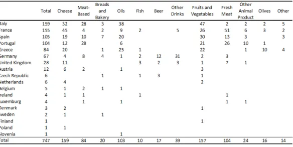
One of the attempts to build the information system on traditional food products is
QualiGeo from Italy (Figure 1). It is a project supported by Qualivita Foundation.
It provides the information on traditional food products from Italy and Spain. The
information includes non-geographical information like the introduction of the
product. The website presents the distribution of food products as the atlas without
many options to interact in the map.
Figure 1: Webpage on the information of food product from QualiGeo.
(Source: www.qualigeo.it Retrieved February 19, 2009)
2.4Web-based GIS
As is universally recognized in the literature, GIS supports complex spatial
decisions through advanced visualization, interactive modeling, and analysis
environments (Densham and Armstrong 1994, Densham 1996). GIS is thus far
utilized to help with perception and understanding of spatially distributed
phenomena in many areas of decision making and evaluating problems (Sakamoto
and Fukui 2004).
Meanwhile, the WWW is becoming the core medium for distributed computing in
IT generally and in the geo-processing domain specifically (Hecht 2002a). In
architecture, now are evolving to a web services model (Dangermond 2002). In
this new architecture, the web is used for delivering not just data, but
geo-processing functionality that can be wrapped in interoperable software
components called web services (Anderson and Moreno-Sanchez 2003). These
components can be plugged together to build larger, more comprehensive services
and/or applications (Hecht 2002b). The web could provide the platform meeting
the need for ubiquity, ease of access, flexibility, and reducing risk of isolation and
obsolescence. Therefore, the benefits of GIS could widely spread in the web.
The web-based GIS provide basic GIS functions to users with browsers. The
ability to pan, zoom, turn data layers on and off and, more importantly, to query
and view attribute data linked to mapped objects, is widely available (Drummond
and French 2008). More sophisticated techniques such as routing and
point-in-polygon analysis are becoming available. This type of online mapping technology
has been used to support local comprehensive planning efforts and interactive
mapping of neighborhood indicators (Sawicki and Craig 1996, Craig 1998).
The development of the web-based GIS is consistent with changes in the Web.
Web 2.0, a new generation of Internet services and technology or the second wave
of the WWW (Deshpande and Jada 2006), encourages significantly more
interaction between users (Boulos and Wheeler 2007, Schuurman et al. 2008).
This evolution leads GIS away from data browsing, analyzing and managing for
individual decisions, and more towards group participating and communicating on
social decision issues (Carver 1999). As Craig et al. (1999) describes the Public
Participation GIS principles as accessibility, understandability, and accountability,
Web GIS continues to draw attention as a public participation tool (Sakamoto and
Fukui 2004).
Recently, many websites or application such as Google Maps, Google Earth,
OpenStreetMap, Yahoo Maps and Microsoft’s Live Search Maps provide many
kinds of geographical related information such as detailed maps, satellite images
and terrain maps all over the world. Several of these sites provide Application
and functions (Drummond and French 2008). Those websites offer a GIS interface
for displaying and combining geographically related data (Cheung et al. 2008),
while the APIs allow users to produce mashups, or applications that display
user-generated content on top of the commercial site’s data and take advantage of the
site’s display and query capabilities (Drummond and French 2008).
There are many case studies and applications on web-based GIS in various areas.
Carver (1999) shows an example of a web GIS-based social decision support
system by means of a site selection problem for radioactive waste disposal. Gao
(2008) developed a service oriented architecture for online disease mapping,
which can enhance the efficiency and effectiveness of public health surveillance.
Wikimapia.com allows users to post location-specific notes and comments onto
Google Earth, much as users provide the content for Wikipedia. This creates an
opportunity for users to provide input about features or conditions at particular
locations (Drummond and French 2008).
Overall, the web-based GIS is a great platform to share and manage the
geographical related information in a ubiquity, visualization and interactive way.
These kinds of characteristics in web-based GIS meet the needs for managing and
presenting the Portuguese traditional food products which are closely associated
with their geographic distributions.
2.5Web technologies for web-based GIS
Following is a brief introduction of some web technologies which are used in the
prototype.
2.5.1Web server
Web server is the server that accepts HTTP requests from clients, and serves them
HTTP responses along with optional data contents, which usually are web pages
such as HTML documents and linked objects such as images. The most popular
web server software is Apache based on Netcraft survey in January 2009. Apache
operating systems, including Microsoft Windows, UNIX, and Linux. It supports
many programming languages like PHP, Perl, Python and Ruby.
PHP is a widely-used general-purpose scripting language that is especially suited
for web development and can be embedded into HTML. It generally runs on a
web server, taking PHP code as its input and creating web pages as output. It can
be deployed on most web servers and on almost every operating system and
platform free of charge. The advantage of PHP is that it could generate the
dynamic webpage retrieving information from database in the server side.
2.5.2JavaScript
JavaScript is a scripting language widely used for client-side web development. It
was the originating dialect of the ECMAScript standard. JavaScript was
influenced by many languages and was designed to look like Java, but is easier for
non-programmers to work with. As used in client side, it is a dynamic, weakly
typed, prototype-based language with first-class functions, and helps to reduce the
request to the server.
2.5.3API
API is a set of routines, data structures, object classes and/or protocols provided
by libraries and/or operating system services in order to support the building of
applications. An API may be:
Language-dependent, that is, only available in a particular programming language, utilizing the particular syntax and elements of the programminglanguage to make the API convenient to use in this particular context.
Language-independent, that is, written in a way that means they can be called from several programming languages (typically an assembly/C-levelinterface). This is a desired feature for a service-style API which is not
bound to a particular process or system and is available as a remote
The API itself is largely abstract in that it specifies an interface and the behavior
of the objects specified in that interface. The API acronym may sometimes be
used as a reference not only to the full interface but also to a single function or
even a set of multiple APIs provided by an organization. Thus the scope is usually
determined by the person or document that communicates the information. Based
on the API documents, the user could learn and combine exist functions in the
application more easily and efficiently.
2.6Open specifications for web-based GIS
The open specification provides information about a given specification as well as
specific programming rules and advice for implementing the interfaces and/or
protocols that enable interoperability between systems (Moreno-Sanchez et al.
2007).
The Open Geospatial Consortium, Inc. (OGC) is a non-profit, international,
voluntary consensus standards organization that is leading the development of
standards for geospatial and location based services. OpenGIS is a Registered
Trademark of the OGC and is the brand name associated with the Specifications
and documents produced by the OGC. OpenGIS Specifications support
interoperable solutions that "geo-enable" the Web, wireless and location-based
services, and mainstream IT. The specifications empower technology developers
to make complex spatial information and services accessible and useful with all
kinds of applications.
Most of the OGC standards are based on a generalized architecture captured in a
set of documents collectively called the Abstract Specification, which describes a
basic data model for geographic features to be represented. Atop the Abstract
Specification are a growing number of specifications, or standards, that have been
(or are being) developed to serve specific needs for interoperable location and
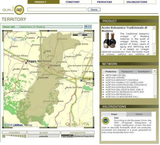
geospatial technology, including GIS. Most of well-known specifications are the
Coverage Service (WCS). Figure 2 indicates the relationships among some
specifications provided by OGC.
Figure 2: Geoservices server with interfaces and applications sketch.
(Green represents read and write paths. Dotted arrowed line indicates mostly read-only data flow) (Source: http://en.wikipedia.org/wiki/Open_Geospatial_Consortium Retrieved February 19, 2009)
WMS provides a simple HTTP interface for requesting geo-registered map images
from one or more distributed geospatial databases. A WMS request defines the
geographic layer(s) and area of interest to be processed. The response to the
request is one or more geo-registered map images (returned as JPEG, PNG, etc)
that can be displayed in a browser application. The interface also supports the
ability to specify whether the returned images should be transparent so that layers
from multiple servers can be combined or not. Therefore, it allows for a smooth
integration of different (raster or vector) maps in web mapping applications over
2.7Open source software for web-based GIS
Open source software are programs whose licenses give users the freedom to run
the program for any purpose, to modify the program, and to freely redistribute
either the original or modified program without further limitations or royalty
payments. There are many open source software available to develop the
web-based GIS. The descriptions on software below are some of them selected to be
used in the prototype.
2.7.1PostGIS/PostgreSQL
Spatial databases are an extension of general purpose databases, and they provide
spatial indexing and support spatial queries. These features improve performance
for geospatial applications. In this prototype, since the open source database
PostgreSQL with PostGIS extension could support spatial features very well, they
are used for the spatial database.
PostgreSQL is a powerful, open source object-relational database system. It has
more than 15 years of active development and a proven architecture that has
earned it a strong reputation for reliability, data integrity, and correctness. It runs
on all major operating systems, including Linux, UNIX and Windows. It has full
support for foreign keys, joins, views, triggers, and stored procedures (in multiple
languages). It includes most SQL92 and SQL99 data types. It also supports
storage of binary large objects, including pictures, sounds, or video. It has native
programming interfaces for C/C++, Java, .Net, PHP, Perl, Python, Ruby, Tcl,
ODBC, among others, and exceptional documentation.
PostGIS is a project which adds support for geographic objects in PostgreSQL,
allowing it to be used as a spatial database for GIS, much like ESRI's SDE or
Oracle's Spatial extension. It implements the OGC standard (Simple Features
Specification for SQL) for spatial extensions to the SQL language, and is widely
supported by other GIS software. PostGIS also allows the creation and use of
in PostgreSQL. This can provide significant performance gains when making
spatial queries (WALDRON et al. 2006).
2.7.2GeoServer
GeoServer is an open source software server written in Java that allows users to
share and edit geospatial data. Designed for interoperability, it publishes data from
any major spatial data source using open standards. GeoServer is the reference
implementation of the WFS and WCS standards, as well as a high performance
certified compliant WMS. GeoServer forms a core component of the Geospatial
Web. Compared to the MapServer, GeoServer supports the most of GIS functions
rather than only publish spatial data. In order to make sure the extendibility of the
prototype, the GeoServer is preferred, though limited GIS functions are needed
now.
2.7.3GeoWebCache
Maps are relatively static, and do not change very often. As most mapping clients
render WMS data every time they are queried, this can result in unnecessary
processing and increased waiting time. GeoWebCache optimizes this experience
by caching map tiles as they are requested, in effect acting as a proxy between
client such as OpenLayers and server such as GeoServer, or any WMS-compliant
server. As new maps and tiles are requested, GeoWebCache intercepts these calls
and returns pre-rendered tiles if stored, or calls the server to render new tiles as
necessary. Thus, once tiles are stored, the speed of map rendering increases many
times, making for a more seamless user experience. The primary purpose to use
GeoWebCache is to reduce the response time of the prototype.
2.7.4JavaScript libraries
Many JavaScript libraries have been developed for GIS nowadays. OpenLayers is
OpenLayers is an open source JavaScript library released under a BSD-style
License for displaying a dynamic map in web browsers. It provides an API for
building rich web-based geographic applications similar to Google Maps and
MSN Virtual Earth. The library includes components from the Rico JavaScript
library and the Prototype JavaScript Framework.
Ext JS is a JavaScript library for building interactive web applications using
techniques such as AJAX, DHTML and DOM scripting. It includes high
performance with customizable UI widgets, well designed and extensible
component model, an intuitive, and an easy to use API. Both commercial and
Open Source licenses are available.
MapFish is an easy-to-use and extensible web 2.0 mapping application framework.
It is composed of two parts: MapFish Client and MapFish Server. MapFish Client
is a JavaScript framework based on OpenLayers for the mapping part and Ext JS
for the widgets part. MapFish Server is responsible for server side treatments and
composed of several modules which can be implemented in several languages
such as Python, Java, and PHP.
MapFish is intended to be easy to use either as a standalone application or as an
add-on to an already existing web application. As a standalone application,
MapFish offers ways to simply configure some parameters and quickly have a
working web mapping application. As a framework, MapFish lets you develop
advanced and customized web mapping applications. MapFish API also allows
maps to be simply included in an already existing website such as component
content management or information system oriented applications.
The strengths of MapFish reside in the integration of several components and the
support of the latest Web 2.0 technology. This allows the creation of advanced
Mapping solutions.
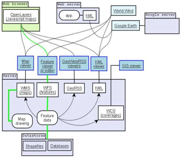
GeoExt is a JavaScript library providing the groundwork for creating
web-mapping applications based on OpenLayers and Ext. Though GeoExt is still in the
released yet, some new features targeted for its first release really get the attention.
GeoExt and Mapfish are going to cooperate closely throughout, and Mapfish will
import the new features from GeoExt in future, so it could be considered as
GeoExt is one of the components in Mapfish.
Figure 3: Relationship among OpenLayers, Ext JS, GeoExt and Mapfish.
Overall, Mapfish successfully aggregates the most of JavaScript which will be
used in the prototype for web-based GIS, though APIs from different libraries
may have been used when doing some specific functions. The general relationship
between four JavaScript libraries for GIS is shown in the figure 3.
2.8Conclusion
Certification labels, especially geographical indications like PDO and PGI are the
very important components for building quality into the traditional food products.
While Portugal has a high number of traditional food products compared to other
EU members. So there are needs to have the information management system,
which could interoperate with other systems, and to get attention from public to
spread the information on Portuguese traditional food products. The web-based
GIS have been developed into a comprehensive and interactive GIS platform, and
may provide an efficient way to manage the information considering one of its
key information is geographic information. Open specifications and open source
software such as WMS and Mapfish are available to make building a web-based
3.
Methodology
The original information system on traditional food products is described in the
beginning. Then end users of web-based GIS are defined, and their requirements
are documented. Based on those requirements, the architecture of the web-based
GIS is designed. At the end of the chapter, the system environment for developing
and testing the web-based GIS prototype is described in detail.
3.1Original information system
The original system for Portuguese traditional food products uses Microsoft
Office Access 2003 to manage the information. The size of the single Access file
is around 126MB, with 33 tables to store the information, and 34 queries, 36
forms and 15 reports to input and retrieve the information. There is no spatial
information in the system.
3.2User requirements
The general requirement is the information management system which could
show the information of Portuguese traditional food products by web map.
There are two types of end users: the staff and the public. The staff are working in
GPP, and using the original information system to manage the information. They
have the training in how to use the system, and the efficiency is their main
concern. While the public do not receive any training for the system and their
technical skills vary greatly. So the user-friendly interface is very important.
For the staff, considered introducing geographic information, a new database may
be required. If so, it needs to be compatible with the original database as much as
possible. The information can also be managed by the web interface efficiently.
For the public, the web map showing the information should be easy to use and
the interface should be user-friendly. The web map should meet following
Basic web map components: zoom bar, navigate bar, zoom in/out tools,
map history, legends;
The switch among two islands and continent is easy and efficient;
Different base maps such as satellite maps, road maps and terrain maps;
Provide the distribution of Portuguese traditional food products;
Provide other information of Portuguese traditional food products, such as
product pictures, certification logo, its Agrupamento and OPC addresses
and so on;
Provide the information of freguesia, like the name and the list of products
distributed in that region;
Provide the information of Agrupamento de Produtores, such as the detail
address information and the list of products related to it;
Provide the information of OPC, such as the detail address information
and the list of products regulated by it.
3.3System architecture
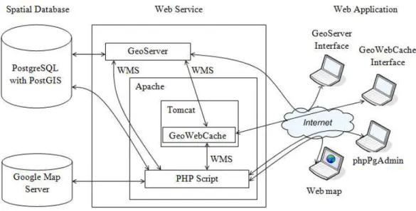
The system is designed as a three tiered software architecture comprising of Web
Application, Web Service and Spatial Database (Figure 4).
In web application, there are the website using JavaScript libraries to show the
information with some basic GIS functions and several web interfaces for the
management.
In web service, there is the web server using Apache, which supports PHP script
to generate the webpage dynamically. The web server also supports
GeoWebCache by Tomcat extension. GeoServer provides WMS directly or
through GeoWebCache.
In spatial database, PostgreSQL database with PostGIS extension are used to store
spatial and non-spatial information. Meanwhile, Google Map Server provides the
Figure 4: System architecture for the web-based GIS prototype.
A typical route for retrieving information is that the client sends the requests to
the web server. Through the PHP module, the web server sends the requests to the
PostgreSQL database, which usually are SQL sentences, to get the non-spatial
information. Then the database returns the results to the web server. For spatial
information, the web server sends WMS requests to the GeoServer or the
GeoWebCache. For GeoWebCache, it will check if it has the request image in the
cache. If so, it will send the results to the web server directly, otherwise, it will
send the WMS request to GeoServer. After getting the request, GeoServer will
fetch geographic information from database, and then GeoServer sends the results
back to either the GeoWebCache or the web server. GeoWebCache sends the
results to the web server. In the end, web server returns the results to the client
side.
3.4System environment
The web-based GIS prototype is developed and tested in a HP laptop, with Intel
Core Duo CUP T7300, Mobile Intel 965 Express Chipset Family and 2GB RAM.
Microsoft Windows XP Professional with Service Pack 3 is used as the operating
system. The web server is using Apache HTTP Server 2.2.9 with PHP 5.2.6
phpPgAdmin 4.2.1 is used for the web interface for the database. The GeoServer
1.7.1 is installed. Apache Tomcat 6.0.18 is installed to support the GeoWebCache
1.0.1. The Apache HTTP Server and GeoServer are using the default port 80 and
8080 respectively, while GeoWebCache is using 8888 port. Notepad++ 5.1.4 is
used as the editor for the website, and Firefox 3.0.6 is used as web browser.
3.5Conclusion
The original information system on Portuguese traditional food products uses the
Microsoft Office Access 2003, without any spatial information. There are two
types of end users for the web-based GIS prototype: the staff and the public.
Based on their requirements, the system architecture is designed as a three tiered
software architecture comprising of Web Application, Web Service and Spatial
4.
System implementation
In this chapter, the descriptions of system implementation are divided into three
parts: spatial database, web server and web application, based on the system
architecture designed in the previous chapter.
4.1Spatial Database
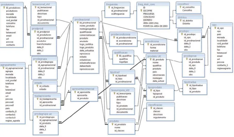
The structure of the original database is shown in Figure 5. Because the prototype
will focus on the traditional food products in Portugal, the traditional food
products from other EU countries will not be considered in the prototype. Thus
the tables which only contain information on traditional food products from other
EU countries are removed, and the database structure is simplified as Figure 6.
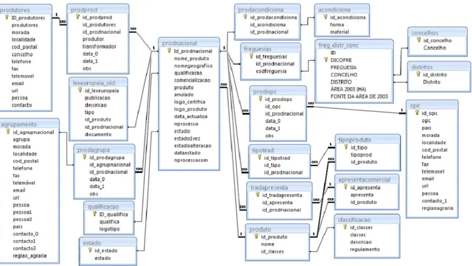
The simplified database structure consists of several aspects on traditional food
products. One of them is the information about food product itself, including the
regulation, the statue of certification, the category it belongs, and so on. Another
aspect is the information about participants in the traditional food products, such
as producer, agrupamento and OPC. But the information about producer is not
collected completely yet, so it will not be well considered in this prototype at the
moment. Last one is the distribution of each Portuguese traditional food products.
In order to be compatible with original database as much as possible, only few
changes have been made (Figure 7). The original table named “lexeuropeia_old”
is divided into two tables, which are “produto_lex” and “lex”, because of the
duplication of values of “lex” in the records. The key “regulamento” from table of
“classificacao” is separated as a table named “regulamento”. The relationship
between tables of “apresentacomercial”, “tipoproduto” and “apresenta_categoria”
could be improved, but the prototype does not need much information from those
tables based on the user requirement. So there is no change for their relationship.
In addition, some names of tables have been changed to clear their meaning. For
example, the table named “produto” is changed to “categoria”, which contains the
The refined database does not contain any geographic information yet. But there
are some information related with locations, such as the distribution of products in
the table of “freguesia”, and the address in the tables of “agrupamento”, “opc” and
“produtor”.
The information of table “freguesia” is updated using Carta Administrativa Oficial
de Portugal (CAOP) version 2008.1 from Instituto Geográfico Português. CAOP
version 2008.1 includes 5 shapefiles with different spatial reference systems,
which are for Continent, Madeira and Açores (eastern, central, western).
Shapefiles for Madeira and Açores (eastern, central and western) are converted to
the same spatial reference system as Continent, using AcrGIS 9.2. After that, all
the shapefiles are converted into PostgreSQL database supported with PostGIS
extension using the command provided by PostgreSQL “shp2pgsql”. In the
original database, though there is a key named “dicofre”, it is different from the
key of “dicofre” in shapefiles of CAOP version 2008.1. Therefore the name of
“freguesia”, “concelho” and “distrito” are used to identify each entity, and then
update information of the attributes. Thus, the new column named “the_geom” is
introduced. The shape of freguesia is polygon.
The addresses of “agrupamento”, “OPC” and “produtor” are related with location.
The information of “produtor” is not considered in the prototype, so the
geographic information is only introduced to tables of “agrupamento” and “OPC”
with additional key named “the_geom”. The key of “the_geom” is point. It could
be updated by Well-known text (WKT). WKT is a text markup language for
representing vector geometry objects on a map, spatial reference systems of
spatial objects and transformations between spatial reference systems, using
longitude/latitude coordinates. The coordinates are supposed to be gathered later.
Overall, the original database are refined to simply the database structure and
three geographic attributes are introduced into the database, one of them is
polygon, other two are points, for representing the shapes of “freguesia”, the
4.2Web Server
The spatial reference system has to be defined in GeoServer beforehand, in order
to use the geographic information of COAP. It could be defined in epsg.properties
file in user projection folder. The EPSG number is defined as 900914 in this
prototype, with following EPSG WKT definition:
PROJCS["ETRS_1989_TM06-Portugal", GEOGCS["GCS_ETRS_1989",
DATUM["D_ETRS_1989",
SPHEROID["GRS_1980", 6378137.0, 298.257222101]], PRIMEM["Greenwich", 0.0], UNIT["degree", 0.017453292519943295], AXIS["Longitude", EAST], AXIS["Latitude", NORTH]], PROJECTION["Transverse_Mercator"], PARAMETER["central_meridian", -8.13310833333333], PARAMETER["latitude_of_origin", 39.66825833333333], PARAMETER["scale_factor", 1.0], PARAMETER["false_easting", 0.0], PARAMETER["false_northing", 0.0], UNIT["m", 1.0], AXIS["x", EAST], AXIS["y", NORTH], AUTHORITY["EPSG","900914"]]
The spatial reference system used for locations of “agrupamento” and “OPC” is
WGS84, so the standard EPSG number, 4326, is used.
After defining the spatial reference system, GeoServer is connected with
PostgreSQL database. The database name is “produto”. The setting could be done
in Config-Data-DataStores-New in GeoServer web interface.
Next step is publishing the distributions of products and the locations of
“agrupamento” and “OPC” in GeoServer.
There are two main ways to publish the distribution of products. One is using
geometry from table of “freguesia” as one layer, and displaying the distributions
of different traditional food products by filters. The advantage is that the
will request the whole geometries from table of “freguesia” in the database, and
then do the filters instead of parsing the filter to the database, and get the filtered
geometries. Therefore, the performance will be the disadvantage. The other way is
to generate the view in the database for each product, and publish each view to
GeoServer. The advantage is the performance compared to the previous way,
because GeoServer will only request the geometries it needs to display. The
disadvantage is that the distribution of each product has to be published to
GeoServer manually.
For the distribution of the products, the performance is the priority. The whole
geometry of “freguesia” is over 60MB. While the total number of products is
about 110, and do not increase rapidly each year. So in this prototype, we choose
the second way to publish the distributions of the products. Each view of
distribution of food products includes dicofre, name of freguesia, concelho, and
distrito, area, the extra links and the geometry. The Spatial Reference System
Identifier (SRS ID) of geometry in database is not defined since there is no
standard SRS ID for it. Each view is published in Config-Data-FeatureTypes-New.
The SRS ID is using 900914 which is defined as user projection previously.
For the locations of “agrupamento” and “OPC”, there are two ways to publish it to
GeoServer too, similar to the ways of publishing the food products distributions.
Considering the geometries of location is points and relatively small. The first
way, as using geometries from two tables as two layers, and displaying the
individual location of office by the filter, is used. The spatial reference system of
geometries from two tables is WGS84, thus the SRS ID is 4326.
There is no need to configure after default installation for GeoWebCache, because
the domain for GeoServer is localhost:8080 in the prototype. Otherwise, the
configuration can be done in the file of geowebcache-servlet.xml, so that
GeoWebCache could configure itself automatically against the WMS
GetCapabilities document, and EPSG:4326 and EPSG:900913 are available,
The GeoWebCache is used for the distribution of food products, but not for the
locations of “agrupamento” and “OPC”, because the GeoWebCache does not
support filter parameters in WMS yet.
The performance of the prototype is improved obviously after using
GeoWebCache. Before using GeoWebCache, the response time for requesting the
distribution of one product will take around 3 seconds, and the user could feel the
obvious delay. After using GeoWebCache, the response time for requesting the
same distribution reduces to less than 1 second, and no delay could be felt.
4.3Web Application
After the web services are setting up and running properly, the user from GPP can
manage the database by the web interface provided by phpPgAdmin without much
modification. The web services, such as GeoServer and GeoWebCache, have their
own web interfaces to manage. So there is no extra web interface designed for
managing the information.
The next step is designed a user-friendly web interface for the public to show the
map on Portuguese traditional food products. The website use APIs from Mapfish
and GeoExt to set up the map and provide some basic GIS functions. The Mapfish
1.0.1 has been used without any modification. While in GeoExt part, the LegendP
anel.js downloaded from https://geoext.org/trac/geoext/attachment/ticket/2/Legen
dPanel.js is imported and modified to be able to use in the prototype.
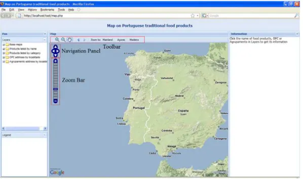
The layout of the default webpage is show in Figure 8. There are four sections in
this webpage. In the top, it is the title of the website. The main map panel is
shown in the center of the webpage, with a toolbar panel attached under the title
of the panel, and the control panels in the left of map. Next to the map panel, it is
the panel including two sub-panels which are for layers and legends in the left
side, while in the right side it is the panel providing information based on
Figure 8: Layout of the web map
The components in the website are described in details as following:
Main map: It is located in the center of the webpage, and is the main componenet
to show the geogrpahic information and link non-geographic information of
Portuguese traditional food products. Its size could be adjusted by the left and
right edges.
Zoom bar: It provides the buttons of zoom in and out on the top and bottom of
the bar respectively. In the middle of the bar, it shows the current zoom level in a
good visual indicator, and is able to zoom to specific zoom level in just one click.
Navigation Panel: It offers intuitive and precise panning. The functions from
Zoom bar and Navigation Panel could be made simpler and quicker by rolling or
moving mouse.
Toolbar: In the toolbar, the first three buttons provide the functions related with
zooming and moving. One advantage of zooming buttons is that it could zoom in
or out either by one simple left click to zoom one level up or down, or by drawing
the box to zoom in or out to the selected areas. The left and right arrow offer
to get the map from history whenever they want. Another user-friendly design is
the shortcuts to the specific geographic area. The two islands in Portugal, Açores
and Madeira, are far away from the mainland. These shortcuts help user to quickly
navigate among three locations without dragging for a long time in the map.
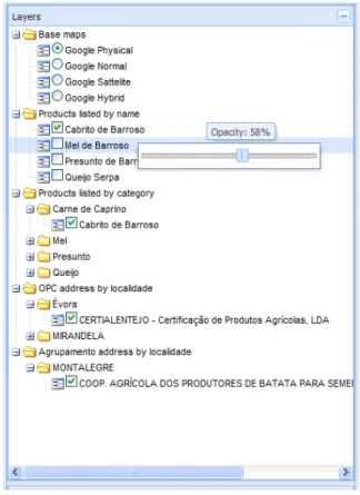
The left panel next to the main map includes layers and legends, and its width
could be adjusted by the edge or hidden by the arrow button on the top.
Figure 9: Layer tree panel.
Layers: It is the place to list available layers in the map. Considering the list of
layers is long, the list is grouped by their characteristics (Figure 9).
Four types of Google maps are provided to be the base map. Only one of base
map can be selected.
The layers related with products are grouped by two ways, listed by their names or
by their category, while the layers related with OPC and Agrupamento locations
the information needed for grouping are retrieved from database. These layers
could be chosen multiple in the clickable box. Lefting click the name of the layer
will get the more information related with clicked layer, while righting click the
name will provide the operation to change the opacity of clicked layer.
Legends: The panel of legends will automatically generate the name and the
legend for the layers, except base maps (Figure 10).
Figure 10: Legend panel.
Information: The purpose of this panel is to provide the non-geographic
information. The tip in the panel is to help user easily learn what function is
available.
After the product name in panel of layers is clicked, it will provide some
introduction of the products including the product name, picture, regulations,
certification logos, Agrupamento and OPC locations, extra links and some tips
(Figure 11). All of these non-geographical information are retrieved from database,
while the tip is trying to help user to quickly know the functions provided by the
Figure 11: Information panel showing information on traditional food products.
Based on the tip, click one region in the product distribution, the name, dicofre
and extra link are provided (Figure 12). Below these, the list of products produced
in that region is listed as layer tree. If the product layer is available in the map, it
will give the clickable box to be able to show its distribution in the map.
Similar to clicking the product name, clicking OPC or Agrupamento name will
provide its address details. Meanwhile it also provides the list of product layers
order by alphabet. If the product layer is available in the map, it will give the
clickable box to be able to show its distribution in the map (Figure 13).
The layer tree in information panel helps the geographical and non-geographic
information to be closely related.
Figure 13: Information panel showing information on OPC location.
4.4Conclusion
The original database has been studied, and modified to introduce the geographic
attributes for tables of Freguesia, Agrupamento and OPC. The customized spatial
reference system is defined in the GeoServer, in order to be able to publish the
geographic information from COAP. The different choices are made to publish
the distribution of Portuguese traditional food products and the locations of
Agrupamento and OPC. Beside the web interface provided by phpPgAdmin,
GeoServer and GeoWebCache, there is no extra web interface designed to manage
the information of the products. Then the user-friendly web interface to show the
5.
Conclusions
The need for the web-based GIS comes from the situations faced by the
Portuguese traditional food products. In order to distinguish from other food
products, EU quality schemes are introduced to make traditional food products
more competitively. In quality schemes, the certification labels named PDO and
PGI become tremendous successful in the past years, because those labels clearly
indicate an important feature of traditional food products, geographical
distribution of the products. With the number of Portuguese traditional food
products increasing every year, the management of the information is the
challenge. Plus sharing the information with other EU members and spreading the
information to the public are important for the promotion of the products. Thus
the information system such as the web-based GIS, which considers geographic
information as the main feature and uses open specifications and open source
software, could be a good choice, and has been proved in the thesis.
In the thesis, two main types of end users are defined as the staff and the public.
The staff needs the web interface to manage the information efficiently while the
public needs the user-friendly web interface to get the information easily. Based
on user requirements, three tiered software architecture are designed for the
prototype. PostgreSQL database with PostGIS extensions is used for spatial
database. For the web service, the prototype uses GeoServer and GeoWebCache
to provide WMS. The Apache HTTP server with PHP and Tomcat is set up to
support GeoWebCache. APIs from JavaScript libraries like Mapfish and GeoExt
are used to implement the web map for the web application. In addition, the web
interfaces for managing database, GeoServer and GeoWebCache are provided.
5.1Advantages of the prototype
Compared to the original information system, the geographic information have
been introduced in the prototype. The prototype use open specification, WMS, to
publish the distribution of the products. Therefore, it provides the possibility to
interoperate with other geographical information like soil type distribution to do
further analysis and research on the products.
From the information management point of view, in order to make the prototype
possible to be deployed later, the smooth migration from original system is critical.
In the development of prototype, the changes in database are considered carefully.
Only three tables changed the structures. Two of them are divided into two tables,
considering the duplication. The attribute in another table, “produto_freguesia”,
has to be updated because of the change of “dicofre” code. Some table names are
changed to make them meaningful. In general, most of these changes could be
skipped if improving the performance of database is unnecessary. These kinds of
attentions minimize the barrier of the migration.
In addition, the information in the map is easy to manage and could be done in the
web browser. All the non-geographic information which are from the database
could be up-to-date without any further work as long as updating the information
in the database regularly. For geographic information, updating information is not
just about database, but also GeoServer and GeoWebCache. After updating the
information in the database, the GeoServer has to be updated to generate the new
bounds of the distribution or to add the new distribution as feature type. Then
GeoWebCache need to be reloaded once to update the list of cache layer. All of
those procedures could be done in the web interface provided by software (Figure
14). The advantage of using web browser to manage the information is that it
provides the options to work under any system from anywhere as long as there is
the web browser. Plus, there is no need to install any extra plugin, and the user
with basic web knowledge could manage it without additional training on the
system.
The prototype is built completely based on the open source GIS software, which
means that it is free to use and modify. The budget for buying the software could
be used in the further development and the employees’ training. Though the
source GIS software, the prototype meet the user requirement completely using
open source GIS software, since the user only require some basic GI functions.
Figure 14: Work flow for adding the product into the web map.
Meanwhile, the freedom to modify the code is very important for the development
of prototype. For instance, the API provides by GeoExt to achieve the function of
legend do generate the legends automatically. But after testing the prototype, it
has been found this API affects the function of changing layers in base map, since
base map is not the layer provided by WMS, and therefore, could not pass the
right parameter to the API. To solve the problem, the code for generating legends
in GeoExt has been studied, and figured out that adding one condition checking in
internal function named “changeLayer” could avoid trying to generate the legend
for the base map. Such kind of freedom is only available from open source
software, and it helps the prototype to better meet the user requirements.
For the public, the web map is interactive, and presents the information clearly.
locations of OPC and Agrupamento de Produtores help the public to know the
non-geographic information like the product names and certification labels.
5.2Limitations and further development
Though the management of information could be done by the web browser, the
management interfaces from different components are quite different. This could
increase the time and cost for manager to be familiar with different interfaces. It
can be improved by designing a uniform web interface to manage the components
such as PostgreSQL database, GeoServer and GeoWebCache. For the PostgreSQL
database, the interface could be done using PHP script. It can provide the
functions such as inserting, updating and deleting records in different tables,
similar to phpPgAdmin, but in a more user-friendly interface. For the GeoServer,
there is a developing API named “REST configuration API” to configure the
GeoServer, and it is expected to be published recently. Based on this API, a
simplified interface for user to regenerate the bounds of layers and add new
product layers will be possible. For GeoWebCache, considering that the only
function required for managing the information is reloading the caches and it does
not provide the API in the foreseeable future, it is not really necessary to design
another webpage to achieve the same function.
The public could be segmented into several roles in the future, so that more
functions could be provided in the prototype. The prototype presented in this
thesis is designed to show the information of Portuguese traditional food products
to the public. So the interactions between users and the system are limited. More
roles such as producers and consumers could be introduced into the system in
future. The producers could provide the details of their own farms, by editing the
attributes of the cadastre in the map through WFS, while the consumers could
make comments on the products, and the producers. If so, the authenticate system
will be required to restrict the users’ access to the specific functions in the map.
In addition, the usability test is a very important step for developing the system.
prototype is from Mapfish, and it could be considered as a mature, user-friendly
interface. It will be necessary to do the usability test before deploying the system,
especially if the uniform web interface for managing is included or more
participators are introduced in the system.
In general, the prototype takes advantage of the web, open specifications and open
source software to meet the needs from different users, though it could improve in
some aspects. More important is that the prototype is extendable and open. So the
web-based GIS prototype is suitable for managing and spreading the information
BIBLIOGRAPHIC REFERENCES
Anderson, G. & Moreno-Sanchez, R., 2003. Building web-based spatial
information solutions around open specifications and open source software.
Transactions in GIS, 7 (4), 447-466.
Anon, 2008. Green paper on agricultural product quality: Product standards,
farming requirements and quality schemes. Brussels: Commission of the
European Communities.
Becker, T. & Benner, E., 2000. Zur problematik der herkunftsangabe im
regionalen marketing. Arbeitsbericht Nr. 1, Hobenheim 2000, Hobenheim.
Becker, T. & Staus, A., 2008. European food quality policy: The importance of
geographical indications, organic certification and food quality insurance
schemes in european countries. 12th Congress of the European
Association of Agricultural Economists - People, Food and Environments:
Global Trends and European Strategies. Gent, Belgium (URL:
http://ideas.repec.org/p/ags/eaae08/44455.html, Retrieved February 15,
2009).
Boel, M.F., 2008. The green paper on agricultural product quality. General
Assembly of AREPO (European Association of Geographical Indications).
Brussels.
Boulos, M.N.K. & Wheeler, S., 2007. The emerging web 2.0 social software: An
enabling suite of sociable technologies in health and health care education.
Health Information & Libraries Journal, 24, 2-23.
Bramley, C. & Kirsten, J.F., 2007. Exploring the rationale for protecting
geographical indicators in agriculture. Agrekon, 46 (1), 69 - 93.
Carver, S.J. ed. 1999. Developing web-based gis/mce: Improving access to data
Cheung, K.-H., Yip, K.Y., Townsend, J.P. & Scotch, M., 2008. Hcls 2.0/3.0:
Health care and life sciences data mashup using web 2.0/3.0. Journal of
Biomedical Informatics, 41, 694-705.
Craig, W., Harris, T. & Weiner, D., 1999. Empowerment, marginalization and
public participation gis. Report of Varenius Workshop, 15-17 October
1998. Santa Barbara: NCGIA, 22-24.
Craig, W.J., 1998. The internet aids community participation in the planning
process. Computers, Environment and Urban System, 22 (4), 393-404.
Dangermond, J., 2002. Web services and gis. Geospatial Solutions, 12 (7), 56.
Densham, P.J. ed. 1996. Visual interactive locational analysis, Cambridge, UK:
GeoInformation International.
Densham, P.J. & Armstrong, M.P., 1994. A heterogeneous processing approach to
spatial decision support system. In Waugh, T.C. & Healey, R.G. eds.
Advances in GIS research, proceedings. Sixth International Symposium on
Spatial Data Handling, 10-25.
Deshpande, A. & Jada, A.R., 2006. Web 2.0: Could it help move the health
system into the 21st century? The journal of Men's Health & Gender, 3,
332-336.
Drummond, W.J. & French, S.P., 2008. The future of gis in planning - converging
technologies and diverging interests. Journal of American Planning
Association, 74 (2), 161-174.
Gao, S., Mioc, D., Anton, F., Yi, X. & Coleman, D.J., 2008. Online gis services
for mapping and sharing disease information. International Journal of
Health Geographics, 7, 8.