WHAT LIES BENEATH:
AN ECO-HISTORICAL VIEW OF HIGH ANDES WATER POLLUTION
HEATHER WILLIAMS1
Presentation
“Children and adults sucked with delight on the delicious little green roosters of insomnia, the exquisite pink fish of insomnia, and the tender yellow ponies of insomnia, so that dawn on Monday found the whole town awake.” Gabriel García Márquez (1970), One Hundred Years of Solitude
One of the prescient reveries in Gabriel Garcia Marquez’ baroque infra-world of
One Hundred Years of Solitude tells the story of an episode of insomniac disease brought to the village and spread unwittingly by the Buendía family, whose candy animals have been distributed to everyone in Macondo.
The affliction spreads in the village but at first causes no alarm. Indeed, many delight in their vastly increased productivity with no apparent need for sleep. Shortly, however, amnesia, the accompanying curse of insomnia manifests itself in a collective forgetting. Villagers follow the example of the scion of the Buendía clan, Aureliano, and begin to label common objects whose names they have forgotten, and then write instructions for use on these objects as their functions begin to fade from people’s grasp.
A cow, for example, carries a sign that reads “This is the cow. She must be milked every morning so that she will produce milk, and the milk must be boiled in order to be mixed with coffee to make coffee and milk.” The village persists in carrying out elaborate measures to compensate for the advancing oblivion: “At the beginning of the road into the swamp they put up a sign that said MACONDO and another larger one on the main street that said GOD EXISTS. In all the houses keys to memorizing objects and feelings had been written. But the system demanded so much vigilance and moral strength that many succumbed to the spell of an imaginary reality, one invented by themselves, which less practical for them but more comforting.”
Visitación, the sister of the first-infected Castaure (Patient Zero, as an epidemiologist might deem her), explains the teleology of the disease. “As the sick person became used to his state of vigil, she explains, “the recollection of his childhood began to be erased from memory, then the name and notion of things, and finally the identity of people and even the awareness of his own being, until he sank into a kind of idiocy that had no past.” The scholar of Andean watersheds in the 21st century would do well to find the
sleeper’s bell brought miraculously to Macondo by Melquiades, the gypsy, who allows José Arcadio to resume his diurnal rhythm of night and day, and in so doing, awake from his forgetting and become aware of the absurdity of a living room where objects were labeled and “solemn nonsense was written on the walls.”
The world of water in the high southern Andes today is an amnesiac’s gallery: millenias’ worth of tools for management of water lie unused in plain sight, labeled with lively signs in often-unkempt English and German and French for tourists, while far cruder adaptations for daily tasks prevail alongside them. Next to ruins of exquisitely enginee-red 13th century masterpieces of freshwater conveyance and irrigation are crudely-cut,
leaking ditches lined with cracked concrete, as often as not lacking water to channel to fields and farmhouses. Next to ruins of 2nd century suka qollus, or solar-warmed raised bed
planting systems are badly eroded fields plowed downslope in a manner that robs topsoil with each rain. These poor replacements are largely a result of the ravages of conquest and depopulation of the 16th century and the systems of peonage and slavery that
per-sisted well into the 20th century. But further disturbing are artifacts of recent origin that
lie akimbo: 20 year-old fishing boats and gear lie unmaintained on soggy land near the banks of Lake Titicaca, no longer useful in a lake whose wild fisheries have crashed in the last decade and half, alongside timber and other materials being used for the creation of thousands of artificial trout farms where, ironically, the remaining wild fish in the lake are often fed to the pisciverous trout. Next to fast-expanding urban settlements in the exploding basin cities of Ilave, Puno, Juliaca, and Putina are fields that saw careful ay-noqanaka, or communally-managed rotations of crops and grazing animals, now choking beneath mounds of discarded plastic garbage and expanding sewage fields. At the edge of receding glaciers that feed the lakes in the high Andean basin, miners toil next to generators pumping cannons of water at rock faces, pulverizing the glinting surface of black escarpments for low-grade ore that yields gold. Several dozen kilometers below them downstream, where the puna warms the earth enough for crops in the river bottomlands, villages’ fishing commons and livestock watering grounds flow grey and turbid from mine waste. Arsenic- and lead-rich sediments flow out from the channels onto fields, stunting pasture and killing lambs and calves by the score.
This article ventures a set of observations about a crisis of use-rights to fresh water in the .Lake Titicaca basin. The article is in two parts: the first part sketches the case for seeing the Altiplano’s communities and its great water basins not as suffering from uneven or late industrialization, with lagging regulatory structures for environmental management. Instead, I argue that the Altiplano is better characterized in terms of atomization and a loss of codes that describe and prescribe management practices for terrestrial and aquatic ecosystems. I present the case that post-Conquest patterns of village autonomy and mi-litant self-management of natural resources have rendered rural villages extraordinarily vulnerable to pollution from extractive industries and subsequent informal urbanization. The second part of the paper article explores an experiment in “bottom-up scien-ce,”—inquiry generated by and for communities inside basins—arguing that under pro-pitious circumstances it might serve as a means of re-coding systems of natural resource management. It overviews the Suma Quta project, a project begun in 2009 that attempts to provide some means for citizens to describe the state of their local waters, what general classes of contaminants those waters may contain, and to give people a common language for engaging authorities, their immediate communities, and the general public about what measures can and should be taken to remediate problems or reduce pollution. Civil society initiatives focused on basin management, the article argues, are most likely to succeed where they enable communities to collect watershed data and take action independently, but also to maintain contact with other communities in a horizontal, leaderless network. Such a network serves to establish common standards in data collection and enable citizens to share strategies for outreach and for pollution cleanups.
The millennial hydroscape of the high Andes
At 12,800 feet above the Pacific Ocean, the deep blue waters of Lake Titicaca offer limited options for livelihood. Outside the tourist industries and the small service economy, about half the population in the lake basin ekes out a living balanced between urban informality, mining, and farming. Away from the waters of the lake, most land is ill suited for crops beyond a bit of forage or a small plot of potatoes in small thermal eddies protected from killing frosts. Here, skilled herders marshal flocks of sheep at elevations near that of the lake. Further up, only llamas and alpaca are suited to the steep slopes, the tough Stipa ichu grasses, and the long distances between water sources.
Absent any further explanation, one might assume from present appearances that these harsh, treeless puna lands house the descendants of exiles—people who su-rely came to this place as a last resort, ambushed perhaps by rival groups, mine owners, conquistadors, and slave traders, and condemned to certain poverty on lands barely fit for human habitation.
base. Most estimates of early chroniclers such as Poma de Ayala as well as archaeological surveys of pre-conquest settlements put crop productivity and household wealth in im-mediate pre-Columbian years in the Altiplano at about 10 times what it is today.
Villagers in the region also stress their ancient roots on the land and the ideational foundations of the societies of their ancestors. Aymara accounts of origin tell us that the lake was the site of the sun’s birth and was paired with the creation of Taypicala, “the stone in the middle.” This is the place where people originated and built the city and empire of Tiwanaku, whose ecclesiastical and administrative urban center was located on the lake plateau about 30 kilometers from its present shores. Traditional elders may speak of the lake in legend as a chamaca, a bottomless body of water that collected rains and rivers and let them drain by way of its interior towards the sea. Lake Titicaca, because it is thought to be bottomless, is seen as a kind of large hole communicating with the enormous ocean (mamaquta or jach’a quta) on which the Earth floats. It also receives the rain and so becomes a nexus of water flowing in two directions.
A notable commonality in varying accounts of origins is the centrality of sun, earth, and water. Traditional accounts describe a first creation during which space is progressively organized: the lake, its islands, and the stars, with human life inseparable from the world and meant to exist in harmony with the long lasting processes of earth and waters. Intriguingly, some accounts also put Titicaca and Tiwanaku at the origin of the second creation, suggesting that flood events and fluctuations in the lake were pivotal in the organization and re-organization of human civilization. Local accounts of water’s history in the region parallel hypotheses of observers utilizing carbon dating and sediment cores to reconstruct chronologies. Paleolimnological studies from around the southern lake segment, Wiñaymarka (a Putina/Aymara word meaning “place of eternity”) indicate that in the time of the earliest human settlements in the area the lake level was much higher-- about five meters above current levels, and that the Altiplano had a sea covering perhaps ten times the area of Lake Titicaca. This primal, late-glacial sea, Lake Tauca (43000 km2), covered what is now Lake Titicaca, Lake Poöpó, Uru-uru and the various remaining salt lakes on the high plain (Baied and Wheeler, 1993).
Human societies in the Altiplano developed agriculture quite early, .with pollen evidence placing the beginnings of regional agriculture about 6,000 years ago (Bouysse--Cassagne, 1992: 477). Early innovations included tubers from the Solanaceae family that yielded calorific starches without the toxic glycol-alkaloids of their wild relatives. The record also suggests that early farmers also probably experimented with amaranths and eventually gravitated toward protein-rich grains like quinoa and cañihua that today are still at the heart of most people’s daily diets.
freezes, drought, flood, and hail, appear to have driven an early conversion of societies from gathering to domestication of animals and settled agriculture. Depletion of forests by 2000 years BCE was an important driver in mixed food systems that utilized animal dung for fuel and crop nitrogen, and tuber and grass crops as a means of creating a year--round food supply through summer rains and winter drought (Bouysse-Cassagne, 1992; Paduano et al. 2003: 274).
In terms of human civilization, one might borrow from Charles Tilly by saying that the landscape made the state and the state made the landscape. The region was a center of a number of early complex states in the Americas that deployed systems of tribute and technological innovation and diffusion that enabled human communities to survive crop failure, even at times through multiyear climate disasters. By 2000 years BCE, Bouysse--Cassagne’s work (1992), for example, indicates that communities in the Altiplano, in Pucará to the north and Chiripa to the south were using the same agricultural technologies of ridged fields. Both show evidence of a highly mixed economy, with use of lands for crops, fish, birds, and herding. What appears to be key in understanding state forms was the ability of hierarchies to oversee the formation of rule-bound management regimes that enabled populations to endure extreme weather events that destroyed crops once every five years on average.
The work of Alan Kolata and collaborators Carney and Binford (1993, 1996, Carney et al. 1996), though not uncontroversial among archaeologists, is probably the most cited set of working hypotheses on the agro-technologies that fueled the rise of the Tiwanaku city-state and empire around the 2nd century BCE. examined the suka kollus, or raised
fields that utilized water channels around crop mounds in order to modulate nighttime soil temperatures and reduce losses from frost. In experimental plots with reconstructed raised beds, utilizing no machine labor or chemical inputs, farm crop yields were about seven to ten times higher than in typical non-raised fields. This vastly increased productivity helped solve the riddle of how the city of Tiwanaku, with its cobbled streets, closed sewers and expanses of hewn granite walls and monuments could have been built in what appeared to be so marginal an agricultural environment by the 1980s, when the experiments were conducted. Kolata and Binford estimated that the traces of 70,000 acres of raised beds that were in evidence in the Lake Titicaca plain provided food for approximately 120,000 people at the empire’s apex. At that time in the Americas, probably only the population of Teotihuacán may have exceeded it (Mann, 2005).
elites, and local access to land, water, and other necessities was granted in exchange for tribute labor for infrastructure and surplus crops. Individual communities and households within them were required to pay tribute through the mit’a, a system of rotating labor that generated state surpluses. In this system, regional descent groups (ayllus) were obligated to provide each year a quota of adult males from their communities for state projects.
The vast expanse of the Incan empire at its height at the turn of the 16th century is well known and cannot receive proper attention here. Salient considerations, however, include the observation that within one hundred years of rule, Inca Pachakuti, his son Inca Tupac Yupanqui, and his grandson Inca Ccapác extended the boundaries of Incan rule from the highlands of modern-day Ecuador well into the northern mountains of what is now Argentina, connecting the four constituent republics of Tiwantinsuyo through some 40,000 kilometers of roads, bridges, and causeways—a grid about the half the size of today’s U.S. interstate highway system. This road system was second technologically only to the Incas’ hydraulic and earthworks network. At its height it covered 2.5 million acres—the largest system of complex hand-built terracing and aqueducts in human history. That the impossibly vast Incan Empire should have risen so rapidly without rapid transportation and mass communication, as Mann has argued, indicates a sphere built more heavily on principles of hegemony than on assimilation (Mann, 2005: 78). That is to say, the rise of Tiwantinsuyo under the Inca marked not only the ambitions, adminis-trative talent, and capacity for alternate diplomacy and brutality of Incan conquerors, but also the pre-existence of a complex archipelago of high Andean trading societies that utilized multiple ecosystems and networks of regulated exchange and tribute to maintain perennial surpluses of food crops, livestock, and fiber. In other words, one could venture that Incan explosion was necessarily a function of a high degree of state-ness, or procli-vity of Andean societies to build enforceable regimes of taxation and trade that would appear to have enjoyed fairly broad legitimacy. That is to say, although military strength enabled conquest of peoples, the building of empire in varied eco-agricultural regions with specialized systems of production required a fair amount of voluntary compliance if it were to endure over time and diffuse over wide geographic areas.
The destruction of the Incan Empire likewise also cannot receive proper review in this essay. The Spanish conquest not only pulverized the Inca leadership and unleashed warfare and epidemic that reduced the population by somewhere around 80 percent. It left in the Altiplano a radical reorganization of human settlements in which the possibility of reintegrating state forms appropriate to a drought- and flood-prone landscape with extreme climate fluctuations was probably very low.
The late 16th century Andean holocausts left remaining inhabitants inside myriad
forms of externally-controlled and autochthonous organizations. The use of the mita
system by Viceroy Francisco de Toledo, beginning in the 1570s, whereby communities in sixteen provinces in Alto Peru were obliged to send numbers of workers as tribute laborers, contributed to the disintegration of food systems (Bakewell, 1984). Food provisioning through the encomienda system all but collapsed by the latter 17th century due to the
By the latter 16th century, food crops were largely grown on heritable hacienda
holdings, with various forms of peonage emerging in which Indians worked in exchange for the use of land. In addition to mining and agricultural production, the alcabala tax became an increasingly important source of income for the crown despite Indian migra-tion to avoid payment. Pre-saging 20th century wartime and neo-colonial wars, Spanish
authorities attempted to control both colonial authorities and indigenous resistance to taxation through wholesale re-organization and relocation of indigenous subjects into comunidades indígenas.
Undoubtedly, the use of head taxes from all Indian men, pressed for all the harder by the Crown as mining revenues from silver mines by the eighteen century declined, contributed to indigenous uprisings of the late 18th century. Forrest Hylton and Sinclair
Thompson argue, in a manner parallel to this discussion, that an archaeology of paradigms and action best suits the task of understanding forms of contemporary political action by indigenous communities. They argue that an anarchist lens best explains forms of orga-nization: Bolivian peasants and mine workers linked insurgency from one era to another, they argue, using oral history and unseen forms of social organization and subaltern leadership to mobilize blockades and armed resistance from one generation to another. The sieges of Tupaj Katari and Tupaj Amaru in 1781, put down after a year of military gains, later become uprisings in the early 18th century. Similarly, the land grabs of the late
18th century of whites and mestizos seeking to “modernize” the country by putting Indian
lands up for sale meet mass roadblocks in decade after decade.
They argue that these iterated cycles of organization and resistance persisted into and through the 20th century as communities used networked forms of organization to
shape land use patterns and limit the predations of a non-Indian state, often massing to block the entrance of tax surveyors into community territory, and making legal claims of the state by selecting indigenous leaders (apoderados) to represent them before the courts and regional and local government, and many did so claiming hereditary descent from the colonial period (caciques). These representatives formed a loosely coordinated, national network… of cacique-apoderados dedicated to blocking or reversing dispossession and combating the collusion of local officials and land surveyors with aspiring landlords” (Hylton and Thompson, 2007:52).
mainly owing to the introduction of non-native, commercial varieties of kingfish and trout, “The practice that each village had of restricting fishing right to its local inhabi-tants kept a limit on the total number of fishermen in the lake” (Orlove, 2002: 43). In a similar pattern, use-rights to totora reeds have been dominated by village-administered systems that establish heritable plots controlled by families, as well as small-scale markets in reedbed rentals to villages and individuals seeking seasonal use rights to totora beds (Orlove, 2002: 188).
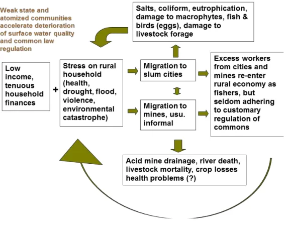
The 1990s began to mark a dramatic shift in three areas: where people lived, what activities they pursued for their livelihoods, and how natural economies were administered. Undoubtedly, military occupation of portions of the lake basin during the Dirty War through the 1980s, investments in mining and tourism after 1990, and infrastructure building under the Fujimori Administration that incorporated thousands of highland rural communities into electric and road grids provoked changes on the Peru side. Meanwhile, on the Bolivian side of the basin, the instability of the 1980s drove hundreds of thousands of citizens out of the mining centers and into peri-urban informal markets.
As a result a shift in the last 20 years by about 40 percent of the population from rural communities to sprawling, informal cities in the basin has altered both the possibility of villages to maintain common-law use rights to resources such as fish and totora, it has also undermined the chemistry of water and soil media that sustain them.
Little more than large towns thirty years ago, the city of El Alto de la Paz now holds over 800,000 people, and two Peruvian cities in the basin top 250,000 people each (Juliaca and Puno). Six medium to large gold and uranium mines drain on the Peruvian side into the basin; at least two major gold mine in the headwaters of the Suchez River in Bolivia also drain into the lake. Several dozen legacy mine sites thre-aten water and land through acid mine drainage and yet-unquantified amounts of heavy metals in the high drainage and near Lago Umayo, a Quaternary-age remnant of a sea that encompassed Lake Titicaca and its downstream twin, Lake Poöpó. With gold ranging as high as $1,800 an ounce in 2011, comments by farmers and miners in the upper basin suggest that dozens if not hundreds of small, artisanal mercury amalgamation operations dot the upper drainage and pose potential threats to streams feeding larger rivers. Meanwhile below in urban settlements, solid waste, detergents, solvents, and organic effluent pose enormous burdens on the riverine environments at lake level.
frequently as rain than snow, and glacial melting occurring concurrently with monsoons, flood and drought events of the last decade have been severe and have displaced tens of thousands of people in the Titicaca basin alone, and many hundreds of thousands or millions in the greater Altiplano.
Despite palpable public rancor about pollution, and despite institutional and legal changes that have created a new Ministry of the Environment and a new national water law, little information about water quality and conservation has been available to communities or urban residents from the state agencies charged with monitoring water quality, including the Autoridad Nacional del Agua, the Proyecto Especial del Lago Titicaca, the Bolivian Autoridad Lago Titicaca, the Secretariat of Fisheries and Oceans, as well as the Ministry of Health. The silence and inaction of water-related authorities amidst a rapid deterioration of the principal river basins feeding the lake areas has fed protest by rural communities in several regions that are acutely affected by mine wastes. In June 2006 and 2007, for example, comuneros from five districts shut down highways leading to the provincial capital of Azángaro and finally the federal highway from Puno to Cusco demanding cessation of off-the-books hydraulic gold mining in the headwaters of the Ramis River, the lake’s largest tributary. The comuneros blasted the Secretariat of Mines and Energy for secret dealings in transporting equipment upstream for illegal mining operations that left downstream communities’ irrigation systems, fields, and pas-tures buried in toxic mine sediment.
The disjointed official response to these protests, along with rumors of payoffs to protest leaders, has fed a general sense cynicism about the prospects for remediation of contaminated areas and regulation of pollution sources. What is notable about the ubi-quitous complaints about pollution is the Manichean nature characterizations of the lake basin. Pollution is considered in terms of it simply being present or absent rather than as having specific properties. “El lago está bien contaminado,” laments one interviewee. “Se han contaminado el Río Ramis los mineros,” comments a comunero in a conversation. The press adds to the confusion with stories entitled “Se busca una descontaminación del lago,” or “Grave, la contaminación del Río Ramis, dicen huelguistas,” or “Urge detener contaminación del Lago Titicaca” (Imagen 2008a, 2008b). Grafitti on walls and boulders reads simply “Alto a la contaminación del Río Ramis,” or “Solución a la contaminción ya!”
In a protest that captured national headlines in May through July of 2011, tens of thousands of indigenous people occupied Peru’s southeast border checkpoints and its main highways for weeks on end. A five-day occupation of the region’s capital culminated with arson and widespread damage. Another protest at the region’s main airport ended in gunfire with six dead and scores of people wounded.
The Suma Quta Project
The rapid collapse of lake fisheries and systems of inter-village regulation of aquatic resources is by no means an event unique to the Lake Titicaca basin. Extractive booms in river and lake basins in Brazil, Guyana, Bolivia, and other parts of Peru (especially the Madre de Dios river basin, where illegal small-scale mining has torn up significant portions of this Amazon tributary since 2007) introduce what a game theorist would characterize as a pattern of universalized defection that can destroy even deeply-rooted patterns of enduring cooperation in a large network of actors (Axelrod, 1984). Fast-growing, makeshift cities, too, introduce an impossible dilemma for self-regulating rural villages dependent on high-quality surface waters and intact aquatic ecosystems: the further downstream cities’ effluent flows, the further afield community members must go for fish, pasture, and reeds. This often results in out-of-bound raids of totora and incursions on fishing grounds, as villagers often point out in portions of Wiñaymarka (the southern, shallow half of the lake) and in Taraco districts north of the lake, and in areas around the mouth of the Coata River, which receives untreated outflows from the city of Juliaca.
To date, a common language for characterizing this absolute trade-off has remained elusive. The problem plaguing the lake basin, characterized by a single word, contami-nación, is ceaselessly talked about in rural and urban circles, and invoked with common urgency. However, the strong understanding of causal links that drove intricate systems of intervillage cooperation over fishing, gathering, and totora use-rights has become far less evident as entire families draw from contradictory income streams that stand in stark opposition to one other.
The Suma Quta (in Aymara language, “Beautiful Lake”) project is a watershed defense initiative being undertaken by a network of local leaders, rural communities, and members of regional government agencies in the Lake Titicaca basin in Puno, Peru. In contrast with many current clean water projects that focus on end-user technologies— typically, initiatives aimed at training individuals about pathogens and equipping hou-seholds with low-cost tools for removing bacteria and protozoa from contaminated water, the Suma Quta project provides data-collection and outreach tools for communities to name (or perhaps re-name), identify and characterize aqueous pollution, and ultimately design campaigns to eliminate or remediate contamination at the source.
community-based water monitoring, an outside methodology developed in the last four decades in efforts in the United States, Mexico, Thailand, Philippines, China, Ecuador, Brazil, Canada, and Ghana.
Rather than imposing a system of imported scientific management on a presumed vacuum of knowledge, the Suma Quta Project aims to be a sleeping bell-- a renewed language and comprehension of existing management tools for people, who, like the citizens of Macondo, have seen their households drawn from older diurnal and seasonal rhythms of cropping and fishing into a frenzied, sometimes 24-hour workday linked to globalized systems of production, accumulation, and waste that obliterate long-standing vocabularies and epistemes of management.
The Suma Quta project aims to generate public information about water quality utilizing networks of volunteer monitors. The project’s goal was to broaden the capacity of communities to document and dispute mining and dumping practices that are im-plicated in human illness and the decimation of fisheries, pasture, crops, livestock and biotic commons. The project emerged from the activities of Ecojuli, a group of biology and environmental engineering students the district of Chucuito who shared rural
grounds and Aymara ancestry; and also through the efforts of outside actors, including this paper’s author. The latter efforts were prompted by interviews and conversations with largely rural women and men in communities in the years 2005 through 2007 who repeatedly pointed out disruptions in their lives and livelihoods stemming from pollution and overfishing, and asked me whether I knew of groups focusing on pollution and clean water. The project was pushed further ahead by the U.S. and Puno-based nonprofit, the Chijnaya Foundation, that had begun work in 2006 on health, education, and development projects in the department of Puno. The Suma Quta project was formally inaugurated in 2009 when 15 volunteers from three grassroots organizations and the government--protected Reserva Titicaca came together to form the first cohort of monitors.
Developed through a process of village and urban consultations and for a, the projects formal structure was set out in four steps: 1) consultar-- consultation; 2) inves-tigar-- investigation with participation and input from community members; 3) concien-tizar-- prompt return of full results to the community and interested public officials in an accessible format; 4) remediar-- discussion of possible avenues for remediation. As the sampling and data-gathering procedures developed through trial and error and sus-tained communications with citizen sciencei projects in Mexico and the United States,
principals leading the project chose to formalize outreach and sampling work using a model of Community Based Water Monitoring developed in the U.S. state of Alabama by Alabama Water Watch and modified in international initiatives under the auspices of Global Water Watch in the Philipppines, Thailand, Ecuador, Mexico, and Brazil (Deutsch et al., 2009).
Originators of the project sought foremost to create community-generated science with hypotheses and tools emanating from residents. In practice, the project took on exotic dimensions both in protocol and form. Ironically, many would-be monitors were attracted to the idea of utilizing what they referred to “modern” and “precise” equipment that bore the mark of outside, foreign origin as a means of gathering evidence that authorities would respect. When shown examples of communities elsewhere, particularly in similar rural settings in Mexico, the Ecuadoran Andes, and remote parts of the Philippines, where monitors used scientific methods and assembled data that would be credible in courts, government agencies, or other technocratic settings, networks of fishers and farmers were very receptive to the idea of sending members of their own ranks to monitoring trainings. Many stated that their hopes that this would lend their grievances greater strength vis--à-vis state officials.
Working with two biologist trainers from the Alabama-based Global Water Watch (Miriam Ramos, of Coatepec, Veracruz and Sergio Ruiz-Cordova, a Guatemalan national), volunteers completed a three-day certification course in chemical, biological, and physi-cal water monitoring methods. The kits and protocols drew directly on formal models of Community Basic Water Monitoring (Deutsch and Ruiz-Cordova, 2005).
lake basin where communities continued to experience conflict and watershed impairment over aggravated sources of pollution.
In addition to several regional environmental awards won by the principals of the Suma Quta project, grassoroots victories of the project thus far include 1) the assembly of georeferenced data on leaking oil wells north of the lake polluted that lent provin-cial authorities decisive new leverage with federal PetroPeru offiprovin-cials, the government petroleum agency that had been charged with cleanup of the site; 2) the cleanup and rehabilitation of a village spring in the community of Parina that supplied approximately 50 families; and 3) the emergence of environmental monitoring and outreach collecti-ves in one city, Ilave, and on the outskirts of Juliaca in the community of Unacolla; 4) partnerships with the Loma Linda University School of Public Health (California) that have enabled the outreach group in Unacolla to mount a public education campaign on bacteriological threats in the water supply, and for leaders of the effort to complete an environmental impact assessment for the city of Juli’s planned sewage outflow system that corroborated the concerns of an adjacent rural community in the vicinity of stormwater containment ponds..
In four years, over 90 monitors have been certified in three-day workshops, and several thousand people have taken part in outreach workshops on water quality and pollution abatement. Noting, however, a high attrition rate for monitors, the EcoJuli coordinators of the program (whose organization is now re-branded as Suma Marka, or “Beautiful Place”) reflected on the dilemmas of the project and conducted interviews with a number of the monitors who had dropped out after going through the initial three-day course in 2009. We found that none reported that they were disillusioned with the mo-nitoring per se, with all citing time constraints as their primary reason for not continuing with the program. But several of the rural monitors had expressed disillusionment with the slowness that any systematic data collection requires, remarking, “We already know there’s a problem with the water. We can see with our eyes what is wrong. What we want are solutions, not just monitoring.” The Suma Marka coordinators also reflected that age might be a factor in retention of monitors. Noting that many of the first monitors, who were older and were the primary income earners in their households, were likely to hold monitoring as a low priority, the the Puno-based coordinators of the project are also developing teams of environmental promotores and school-age environmental brigades who specialize in community outreach.
From fragmentation to linked autonomies?
Stakeholders must consider what claims can be made from their own data, how and to whom it should be presented, and how they can gain substantive roles vis-a –vis municipal, regional, and federal authorities in watershed management.
Ultimately, the effort must aim for basin-wide coverage, for consistency in data quality, but also for political autonomy for constituent communities. If bottom-up citizen science is to do its work, the Suma Quta network must be a means by which communities can make legal claims and challenge state actors and private sector polluters rather than another of maldita autoridad that neither heeds their claims nor advances the cause of the lake’s ancient waters.
Note
i The term “citizen science” is generally used to refer to inquiry carried out by non-scientists, generally in networked form. Conservation and health related examples would include the 100,000 or so amateur birdwatchers who contribute to the annual Breeding Bird Survey or networks of citizens documenting climate change effects. For a discussion of citizen science consistent with this definition, see Eric Hand (2010). A contrasting definition of citizen science is science done or taught by experts in service of public policy goals, For discussion of this phenomenon, see Dominique Brossard et al (2005).
References
Axelrod, R. (1984) The Evolution of Cooperation. New York: Basic Books.
Baied, C. and Wheeler, J (1993). “ Evolution of High Andean Puna Systems: Environment, Climate and Culture Change over the Last 12,000 Years in the Central Andes,” Mountain Research and Development, Vol. 13, No. 2: 145-156 .
Bakewell, Peter (1984). Miners of the Red Mountain: Indian Labor in Potosí 1545-1650.
Albuquerque: University of New Mexico Press.
Bouysse-Cassagne, T. (1992). Ethnology and Socio-economy: Past and Present Human Populations. Lake Titicaca: A Synthesis of Limnological Knolwedge. C. Dejoux and A. Iltis. Dordrecht, Kluwer Academic Publishers: 477.
Bradley, R. S., V. Mathias, V., H. Diaz, W. Vergara (2006), “Climate Change: Threats to Water Supplies in the Tropical Andes, “ Science 312 (5781): 1755-1756.
Brossard, D., B. Lewenstein, and R. Bonney (2005), “Scientific Knowledge and Attitude Change: The Impact of a Citizen Science Project,” International Journal of Science Education
27 (9): 1099-1121.
Deutsch, W. and S. Ruiz-Cordova (2005), Community-Based Water Monitoring: Data Credibility and Other Considerations, Auburn University, web publication accessed May 15, 2012 at https://aww.auburn.edu/Docs/Other/DataCredibility.pdf
Hand, E. (2010). “Citizen Science, People Power,” Nature 466: 685-687.
Hylton, F. and S. Thomson (2007) Revolutionary Horizons: Past and Present in Bolivian Politics. New York: Verso.
Imagen (2008a) “Se busca una descontaminación del lago,” August 3. Puno, Peru, p. 1. Imagen (2008b) “Grave, la contaminación del Río Ramis, dicen huelguistas,” August 3. Puno, Peru, p. 1.
Jenkins, D. (2001). “A Network Analysis of Inka Roads, Administrative Centers, and Storage Facilities.” Ethnohistory 48(4): 655-687.
Kolata, A. (1993), Tiwanaku: Portrait of an Andean Civilization, Cambridge: Blackwell. Kolata, A. (1996), Valley of the Spirits: Journey into the Lost Realm of the Aymara, New York: Wiley.
Mann, C. (2005), 1491: New Revelations of the Americas Before Columbus, New York: Vintage Books.
Orlove, B. (2002). Lines in the Water: Nature and Culture at Lake Titicaca, Berkeley: University of California Press.
Paduano, G. M., M. B. Bush, et al. (2003). “A vegetation and fire history of Lake Titicaca since the Last Glacial Maximum.” Palaeogeography, Palaeoclimatology, Palaeoecology 194(1-3): 274.
Stanish, C. (1994). “The Hydraulic Hypothesis Revisited: Lake Titicaca Basin Raised Fields in Theoretical Perspective.” Latin American Antiquity 5(4): 312-332.
Submitted on: 13/11/2013 Accepted on: 03/09/2014
Abstract: This article in two parts provides a sketch of the Suma Quta (in Aymara langua-ge, “Beautiful Lake”) Project, an experiment in “bottom-up science” begun in the Lake Titicaca basin in Peru in 2009. The article explores the question of why water resource and fisheries management has fallen into crisis in what has been in millennial terms one of the world’s most meticulously managed hydroscapes. It argues that post-Conquest patterns of village autonomy and militant self-management of natural resources have rendered rural villages highly vulnerable to pollution from extractive industries and subsequent informal urbanization. Civil society initiatives on water quality are therefore most likely to succeed where they enable communities to collect watershed data and take action independently while maintaining contact with other communities in a horizontal, leaderless network.
Keywords: Lake Titicaca, pollution, water resource management, civil society, social
movements
Resumo: Este artigo em duas partes apresenta um esboço do projeto Suma Quta (Lago Bonito na língua aimará) um experimento de ciência “de baixo para cima” iniciado em 2009 na bacia do Lago Titicaca, no Peru. O projeto utiliza métodos de monitoramento comuni-tário da água como modo de reforçar o poder dos cidadãos diante do estado na questão de redução da poluição. O artigo explora o motivo pelo qual o manejo dos recursos hídricos e pesqueiros entrou em crise naquela que em termos milenares é uma das paisagens hídricas mais meticulosamente manejadas do mundo. Argumenta que os padrões pós-conquista de autonomia dos povoados e autogestão militante dos recursos naturais deixaram os povoa-dos rurais altamente vulneráveis à poluição causada pela indústria extrativa e a posterior urbanização informal. Portanto, iniciativas da sociedade civil sobre a qualidade da água têm maior probabilidade de sucesso porque permitem que as comunidades coletem dados sobre a bacia hidrográfica e ajam de maneira independente, mantendo contato com outras comunidades em uma rede horizontal sem liderança.
Palavras-chave: Lago Titicaca, poluição, gestão de recursos hídricos, sociedade civil, movimento sociais.
WHAT LIES BENEATH:
AN ECO-HISTORICAL VIEW OF HIGH ANDES WATER POLLUTION
aymara, “Lago Bello”), un experimento en ciencia de base que se inició en la Cuenca Titicaca en Perú en el año 2009. El artículo explora la crisis contemporanea de la contaminación, que ocurre en un hidro-región que por milenios se mantenía meticulosamente. Se propone una esquema teórica en la cual se entiende el Altiplano y sus cuencas no solamente como una región que sufre de un desarrollo industrial retrasado, sino como una region en donde las tendencias pos-Conquista de las comunidades hacia una autonomía y una gestión auto-defensiva de recursos naturales rendían a tales comunidades vulnerables a la contaminación de las industrias extractivas y a la urbanización informal. Por esto, se prevée más exito para las iniciativas de la sociedad civil frente a la calidad del agua que empoderan a las comunidades de juntar datos sobre la cuenca independientemente mientras se mantienen en contacto con otras comunidades en una red horizontal sin autoridades formales.