Received April 05, 2001 / Accepted Julho 12, 2002
THE USE OF SHALLOW SEISMIC REFLECTION
TECHNIQUE IN NEAR SURFACE EXPLORATION OF
URBAN SITES: AN EVALUATION IN THE CITY OF SÃO
PAULO, BRAZIL
Renato L. Prado
1, Walter Malagutti Filho
2& João C. Dourado
2In order to evaluate the use of shallow seismic technique to delineate geological and geotechnical features up to 40 meters depth in noisy urban areas covered with asphalt pavement, five survey lines were conducted in the metropolitan area of São Paulo City. The data were acquired using a 24-bit, 24-channel seismograph, 30 and 100 Hz geophones and a sledgehammer-plate system as seismic source. Seismic reflection data were recorded using a CMP (common mid point) acquisition method. The processing routine consisted of: prestack band-pass filtering (90-250 Hz); automatic gain control (AGC); muting (digital zeroin) of dead/noisy traces, ground roll, air-wave and refracted-wave; CMP sorting; velocity analyses; normal move-out corrections; residual static corrections; f-k filtering; CMP stacking. The near surface is geologically characterized by unconsolidated “fill” materials and Quaternary sediments with organic material overlying Tertiary sediments with the water table 2 to 5 m below the surface. The basement is composed of granite and gneiss. Reflections were observed from 40 milliseconds to 65 ms two-way traveltime and were related to the silt clay layer and fine sand layer contact of the Tertiary sediments and to the weathered basement. The CMP seismic-reflection technique has been shown to be useful for mapping the sedimentary layers and the bedrock of the São Paulo sedimentary basin for the purposes of shallow investigations related to engineering problems. In spite of the strong cultural noise observed in these urban areas and problems with planting geophones we verified that, with the proper equipment, field parameters and particularly great care in data collection and processing, we can overcome the adverse field conditions and to image reflections from layers as shallow as 20 meters.
Key Words: Shallow seismic reflection; Geophysics in urban areas; Nearsurface geophysics; Seismic in São Paulo City.
A técnica CMP mostrou-se útil no mapeamento dos sedimentos e embasamento da Bacia Sedimentar de São Paulo com vistas aos problemas de engenharia. Mesmo em face do alto nível de ruído urbano observado nas áreas investigadas e dos problemas de acoplamento de geofones em superfícies pavimentadas foi possível, com o emprego de equipamentos apropriados, cuidados na aquisição e processamento dos dados, registrar-se reflexões em interfaces a partir dos 20 metros de profundidade aproximadamente.
Palavras-chave: Sísmica de reflexão rasa; Geofísica em áreas urbanas; Geofísica rasa; Sísmica na cidade de São Paulo.
INTRODUCTION
For about seven decades seismic reflection techniques have been successfully used to investigate subsurface features for petroleum exploration.
In the last 15 years, however, this method has been applied to solve engineering and environmental problems as a result of new equipments and advances in processing techniques, besides decreased cost that made it a very cost-effective approach (Hunter et al., 1984; Pullan & Hunter, 1985; Knapp & Steeples, 1986a e 1986b; Pullan & MacAulay, 1987; Steeples & Miller, 1990).
Shallow seismic reflection can be useful in characterizing shallow structures or anomalies within the upper 50 meters of the subsurface, mainly when the seismic refraction method does not work, that is, where the P-wave velocity contrasts between beds are not significant to produce first arrival refracted waves or where occurs velocity inversion, hidden layer or blind zone problems (Schmöller, 1982).
In spite of shallow seismic reflection wide uses, most of the acquisition and processing techniques employed in the oil industry requires more than a simple scaling down. In the urban areas its usage is even more difficult. The noise in urban areas, originating from moving traffic or operating machine, for example, degrades the signal-noise ratio (S/N) or even may obstructs the full use of the shallow seismic technique. The enhancement of the ground roll and the difficulties to plant geophones to the pavement are other problems commonly observed in the acquisition of data in such areas.
Regarding the processing of data, the misinterpretations of refracted waves and air waves as reflections on stacked common mid point (CMP) sections, besides many artifacts that can be generated during the processing, are some of the aspects that make the interpretation of shallow seismic a difficult task (Steeples et al., 1997; Steeples & Miller, 1998). Aiming to delineate the structure and stratigraphy of Tertiary deposits of São Paulo Sedimentary Basin and its basement up to 40 meters depth, a reflection seismic investigation has been carried out at the city of São Paulo in noisy areas where the surface is covered with asphalt pavement.
FIELD DATA ACQUISITION
The ideal sources for shallow reflection applications are those that generate high frequency and low-energy waves. Such sources greatly improve the resolution and minimize the generation of the ground roll and the air-coupled energy. The projectile sources are one of the best to achieve these requirements but they are not recommended and even are prohibited in urban areas due to safety reasons or the presence of pavements.
So, among the non-invasive sources, the impact of the sledgehammer on a plate is almost the only remaining choice and furthermore it is the simplest and cheapest source. Moreover, Ghose et al. (1998) found that it is easier to generate high frequencies on hard ground, like asphalt, than on soft soil, because the former has greater radiation impedance.
1São Paulo University, Brazil
Rua do Matão, 1226 São Paulo – SP / Brazil
2São Paulo State University, Brazil
If possible, it is not recommended to add more impacts because they normally reduce the frequency content of the waves in proportion to the number of added impacts. To do this, it is necessary to verify the accuracy of the triggering system.
In this study we tried to examine the effects of simple changes in sledgehammer system parameters (hammer mass, plate area and plate material) in the amplitude and frequency content of the seismic data. We found that larger plate areas and different plate materials (steel and aluminum) did not increase the seismic energy or the frequency content when acquiring the seismic data on the asphalt pavements. Larger hammer masses increased seismic energy, especially the energy related to the lower frequencies.
In some situations the best results were obtained striking directly on the asphalt pavements.
Table 1 summarizes the effects observed in the quality of the seismic data when some parameters of the sledgehammer system were changed in the tests carried out in São Paulo City and it also incorporates some results shown by Keiswetter & Steeples (1995).
SEISMOGRAPH AND GEOPHONES
The main qualities of a recording system are its resolution, which means the number of bits digitized and its dynamic range (Knapp & Steeples, 1986a).
The newest seismographs have 18 bits or more of analog-to-digital (A/D) converters which means
Table 1 – The effects in the quality of the seismic data due to changes of some sledgehammer system parameters observed in the test areas and compiled from Keiswetter & Steeples (1995).
Tabela 1 – Efeitos da variação de parâmetros da marreta e da placa na qualidade do dado sísmico observados nos testes e compilados de Keiswetter & Steeples (1995).
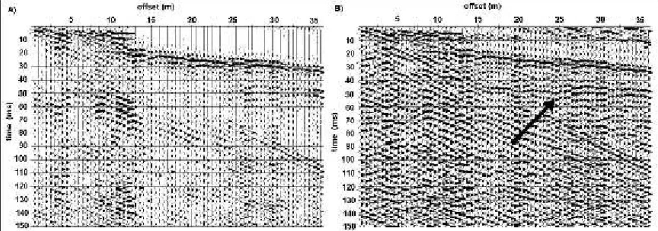
Figure 1 – Seismograms of the walkway analysis test from one of the study areas in São Paulo employing the 10-Hz (A) and 200-Hz (B) low-cut filters. The 200-Hz filter introduces a huge ringing effect of the refracted waves.
dynamic ranges greater than 100 dB, allowing to record waves with differences in amplitudes up to 200 times at the same time. With these modern seismographs (18 or 24 A/D) it is no more necessary, or even contraindicated, the use of analog low-cut filter during the acquisition, which was a necessary procedure in the 1980’s (Steeples et al., 1997).
The use of analog low-cut filters can deteriorate the seismic signal, reducing the frequency bandwidth and intensifying the ringing effect. This was observed in one of the walkway analysis test recorded in the study area, where 10-Hz and 200-Hz low-cut filters were used (Figure 1).
The most recommendable geophones, in order to get high resolution, are those which have a natural frequency in the range of 30 Hz to 100 Hz. The 100 Hz geophones can, sometimes, limit the lower part of the frequency band causing a ringy effect in the seismic data. On the other hand, the 30 Hz geophones are more sensitive to urban noises.
The geophone-ground coupling is a serious problem in urban areas. Most of the time it is not possible to plant the geophones using their spikes. The problem here is to guarantee that the geophone reproduces as faithfully as possible the ground motion. In order to get a signal with as much high frequency content as possible, a large area of contact is desired. One way to get this is to increase the area of contact using a plate or volume of clay.
Planting geophones with clay, instead of metal bases, gave us the best results in this test (Figure 2). Figure 2 – Deployment of geophones with clay and metal base.
Figura 2 – Aspectos da fixação de geofones com bases metálicas e argilas.
Figure 3 – General processing flow chart for shallow reflection data.
Figura 3 – Fluxograma do processamento básico na sísmica de reflexão rasa.
PROCESSING DATA
A method to increase the quality of the seismic data is to remove the noises from the signal, which means muting refractions, air waves and the ground roll.
When the refracted or the air-waves have distinct and dominant phase, spatial filters like f-k can be used to remove them. However the f-k filter can degrade the data, especially when the air-waves are aliased. Most of the time the best alternative is the surgical mute.
In both cases, however, the edges of the muted region should be tapered. The size of the taper region must be large enough to minimize the processing artifacts that occur at the edge of the muted region. Usually, trial-and-error is the best method to do this. Automatic-gain-control (AGC) scaling is a process regularly used to increase the amplitudes of the data, for display or processing purposes. Here the critical parameter is related to the length of the AGC window, which means the time-band within which the amplitudes are normalized. The highest amplitude within this window will strongly determine the normalization. If the AGC window is too small (close to the dominant period of the data) everything will be changed within this interval, on the other hand if it is very large (close to the record length), no effects will be produced in the amplitude of the data. A good rule of thumb is to approximate its length to 2 times the dominant period of the data and to observe the results.
Another undesirable effect related to the application of the AGC gain is the generation of the
“quiet zones” above and below high amplitude events. This is shown in Figure 4where a 50 milliseconds window (A) contributed to mask the reflection event, which is clearer using a 15 milliseconds window (B).
THE SEISMIC SURVEY
This survey was conducted as part of a site-specific study of the feasibility of the use of shallow reflection seismic technique to image the stratigraphy and structure of the nearsurface geology for engineering practices (Prado, 2000), mainly focusing on its use for tunneling works.
Five reflection seismic profiles were acquired in the urban area of São Paulo City where new subway facilities had been planned. Representative results of the field surveys at two sites are presented (Figure 5).
GEOLOGIC SETTING
Most of the urban area of the city of São Paulo is placed on the São Paulo Sedimentary Basin, which is about 75 km long (NE direction) and 25 km wide (NW direction).
The basement is composed of granite and gneiss. The overlying Tertiary sediments are comprised of alternating clay, silt and sand layers of Resende, Tremembé, São Paulo and Itaquaquecetuba Formations (Riccomini, 1989). The geological setting of the study areas is basically the sediments of Resende Formation, which consist of silt clay layers and clay Figure 4 – Effects of the window length on the AGC gain, causing a “quiet zone” in the seismogram A (50 ms time window). The 15 ms time window in the seismogram B brought out the reflection event (arrow).
Figure 5 - Site map indicating the approximate location of the seismic lines.
Figura 5 - Planta de localização das áreas estudadas.
fine sand layers intercalated. They form, normally, a continuous layer of few meters thick.
The nearsurface geology consists of unconsolidated “fill” materials formed basically by sandy clay, sometimes with organic material overlying Quaternary sediments formed by silt clay with organic material.
The water table occurs just a few meters below the surface, normally between 2 and 5 meters depth.
Borehole geotechnical information available at the two sites indicates that the N-values of the Standard Penetration Test (SPT) represent a distinct mechanical property of the sediments and are not necessarily coincident with the grain size (clay, silt, sand) interfaces.
FIELD PROCEDURES AND PROCESSING
sledgehammer blows on a metal plate placed on the asphalt pavement as the seismic energy source. The receivers consisted of 30 Hz and 100 Hz geophones which were planted in the ground with clay.
The selection of the optimum data acquisition geometry, receivers and recording parameters was made in the field after extensive testing and analysis of the walkaway noise test data.
The source-to-receiver offsets were chosen considering a compromise between maximizing the range of offsets to improve velocity analysis and maximizing spatial-sampling of shallow reflections which improve reflector coherency.
The geometry had 20 and 15 meters of minimum offset for Area 1 and 2, respectively, and 1 m geophone spacing for both areas. The shots were taken every 1 m along the survey lines.
Table 2 summarizes the field geometry and recording parameters used in Areas 1 and 2. Seismic reflection data were recorded using a standard CMP (common mid point) acquisition method.
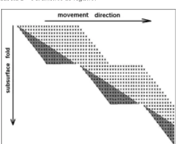
The design of the acquisition used is known as leapfrogging because the receiver line is not moved all at once as the source location moves along the profile, but rather the first half of the receiver spread is moved to the end of the second half of the spread after the twelfth movement of the source. The closest geophone to the source is deactivated at each source movement and after the half of the receiver spread is moved, the 24 channels are activated again. The high amplitude ground roll which is common in shorter offsets than the minimum offset, chosen in the walkaway noise test, was the main reason to deactivate these channels.
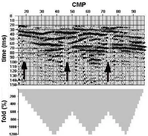
This kind of acquisition reduced the field time and allowed a fold of 100% to 1200% (Figure 6). The uneven fold that was created is because of the leapfrogging technique used and the deactivation of the channels. The minimum fold that was chosen for the stacked sections was 600 %.
It can be noticed in Figure 7 that even a 600 % fold seemed to be insufficient due to the low S/N ratio. In this Figure we can see, as indicated by the arrows, the interruption of the seismic event at 70 milliseconds, which is related to a decrease of the fold and could be misinterpreted as a geological feature.
The seismic data were processed in CMP format using the commercial software package Winseis from the Kansas Geological Survey. The processing routine consisted of: prestack band-pass filtering (90-250 Hz); automatic gain control (AGC); muting (digital zeroin) of dead/noisy traces, ground roll, air-wave and refracted-wave; CMP sorting; velocity analyses; normal move-out corrections; residual static corrections; f-k filtering; CMP stacking (using the 600% to 1200% fold data only).
The upper limit for observing reflection was controlled mainly by the interference between the ground roll and the reflection event for the shortest offsets once the frequency filtering routine does not work consistently to decrease the amplitude of the ground roll.
In the same way, separating the wide-angle shallow reflection from the shallow refraction, for the longest offsets, was another difficult task. This is because they both had a very similar phase velocity and frequency content (in the raw field data, the frequency content of the reflected and refracted waves Table 2 – Recording parameters
Tabela 2 – Parâmetros de registro.
Figure 6 - Fold diagram of the survey. The shaded area represents the subsurface points that were not sampled after turning off the channels.
Figure 7 – Stacked section of Area 2 and its fold diagram. Arrows indicate the interruption of the seismic event at 70 milliseconds due to decreasing fold.
Figura 7 – Seção bruta empilhada da Área 2 e respectivo diagrama de empilhamento. Setas indicam interrupção da reflexão em 70 ms devido à diminuição de cobertura.
Figure 8 – Final stacked and interpreted sections of the Area 1.
varied from 100 to 150 Hz). Most of the time mutting worked better than f-k and frequency filtering for this purpose.
The corrected stacked sections of the Areas 1 and 2 are presented in Figures 8 and 9.
RESULTS
The seismic survey was carried out in areas where wells had been drilled near by the São Paulo Subway Company. So the identification of the reflectors was based on the depth information derived from those boreholes.
Area 1 presented the strongest noise area because of the constant traffic of heavy trucks and many industries that are concentrated around it. But even under this condition it was possible to identify a reflection at about 40 milliseconds and another one at about 55 milliseconds.
The first reflection (arrow 1) is correlated to an increase of the N-values of the SPT, corresponding to the silt clay layer and fine sand layer contact of the Resende Formation, at approximately 20 meters deep.
The sand layer is interbedded with thin clay layers, which were not identified.
The second reflector (arrow 2) is related to the weathered gneiss of the basement of the Sao Paulo sedimentary basin at approximately 40 meters deep. The same reflectors were identified in the stacked section of the Area 2 at about 40 and 65 ms, corresponding to the silt clay/fine sand layer contact (arrow 1) and the weathered gneiss (arrow 2), respectively.
CONCLUSIONS
The CMP seismic-reflection technique has been shown to be useful for mapping the sedimentary layers and the bedrock of the São Paulo sedimentary basin for the purposes of shallow investigations related to engineering problems.
The recorded frequencies of seismic data were strongly dependent on how well geophones were planted and how effectively the source of the seismic signal injected energy into the ground.
Figure 9 – Final stacked section of the Area 2.
The ground roll was a significant problem to identify the shallowest reflection events. At the site conditions, frequency filtering routines do not work to decrease its amplitudes to bring out the reflections at offsets less than 10 meters.
However, we verified that, with the proper equipment, field parameters and particularly great care in data collection and processing, it is possible to obtain reflections from layers as shallow as 20 meters. Because of the strong cultural noise observed in such urban areas and problems with planting geophones, it seems that imaging depths shallower than 20 meters is still a great challenge.
ACKNOWLEDGMENTS
The authors would like to thank FAPESP - Fundação de Amparo a Pesquisa do Estado de São Paulo that funded part of this research (Project 96/12782-6). We also thank the São Paulo Subway Company for allowing us access the geological and geotechnical data and the reviewers for their helpful and constructive comments.
REFERENCES
Ghose, R., Nijhof, V., Brouwer, J., Matsubara, Y., Kaida Y. & Takahashi, T., 1998. Shallow to very shallow, high-resolution reflection seismic using a portable vibrator system. Geophysics, 63: 1295-1309.
Hunter, J.A, Pullan, S.E., Burns, R.A., Gagne, R.M. & Good, R.S., 1984. Shallow seismic reflection mapping of the overburden-bedrock interface with the engineering seismograph - some simple techniques. Geophysics, 49: 1381-1385. Keiswetter, D.A. & Steeples, D.W., 1995. A field investigation of source parameters for the sledgehammer. Geophysics, 60: 1051-1057. Knapp, R.W. & Steeples, D.W., 1986a.
High-resolution common depth point seismic reflection
profiling: instrumentation. Geophysics, 51: 276-282.
Knapp, R.W. & Steeples, D.W., 1986b. High-resolution common depth point seismic reflection profiling: field acquisition parameter design. Geophysics, 51: 283-294.
Prado, R.L., 2000. The use of shallow seismic reflection and the ground penetrating radar for geological and geotechnical investigations in the urban areas. A study in São Paulo City, Brazil. Rio Claro, 2000. 177 p. PhD thesis (Geoscience). São Paulo State University (in Portuguese). Pullan, S.E. & Hunter, J.A., 1985. Seismic model
studies of the overburden-bedrock problem. Geophysics, 50: 1684-1688.
Pullan, S.E. & Macaulay, H.A, 1987. An in-hole shotgun source for engineering seismic surveys. Geophysics, 52: 985-996.
Riccomini, C., 1989. The continental rift of the SE of Brazil. São Paulo, 1989. 256 p. PhD thesis (Geoscience). São Paulo University (in Portuguese).
Schmöller, R., 1982. Some aspects of handling velocity inversion and hidden layer problems in seismic refraction work. Geophysical Prospecting, 30: 735-751.
Steeples, D.W. & Miller, R.D., 1990. Seismic-reflection methods applied to engineering, environmental and groundwater problems. In: Geothecnical and environmental geophysics, 1, Review and Tutorial (Ward, S., Ed.), Investigations in Geophysics nº 5, SEG, p.1-30. Steeples, D.W., Green, A.G., McEvilly, T.V., Miller, R.D., Doll, W.E. & Rector, J.W., 1997. A workshop examination of shallow seismic reflection surveying. The Leading Edge, 16: 1641-1647.