Caminhos de Geografia Uberlândia-MG v. 20, n. 71 Setembro/2019 p.160-181 Página 160 Joiada Moreira da Silva Linhares Instituto Federal do Amazonas IFAM - Campus Lábrea Departamento de Ensino, pesquisa e Extensão Joiada.linhares@gmail.com Wanderley Rodrigues Bastos Universidade Federal de Rondônia Pós-Graduação em Desenvolvimento Regional e Meio Ambiente bastoswr@unir.br Ronaldo Almeida
Universidade Federal de Rondônia Pós-Graduação em Gestão e Regulação de Recursos Hídricos ronaldoalmeida@unir.br Ângelo Gilberto Manzatto
Universidade Federal de Rondônia Pós-Graduação em Desenvolvimento Regional e Meio Ambiente
manzatto@unir.br Igor Bruno Barbosa de Holanda
Universidade Federal de Rondônia Laboratório de Biogeoquímica Ambiental Wolfgang C. PFeiffer igorbruno16@gmail.com Maria Cristina Recktenvald
Universidade Federal de Rondônia Laboratório de Biogeoquímica Ambiental Wolfgang C. PFeiffer mcnn.nery@yahoo.com.br Deborah Pereira Linhares da Silva Instituto Federal do Amazonas IFAM - Campus Lábrea Departamento de Ensino, pesquisa e Extensão deborah.silva@ifam.edu.br
ABSTRACT
An agroforestry system (AFS) describes the conjoint use of land for agricultural and forestry purposes. An AFS plays a strategic role in the mitigation of carbon dioxide (CO2) emissions, and stands as an alternative in land use that reduces mercury (Hg) remobilization in cultivated soils. This study evaluated the spatial variability of Hg concentrations as indicators of environment changes and soil quality in different land cover and use systems in a rural settlement in southern Amazon, Brazil. The methodological procedures were carried out as steps: the experimental units were defined, physical and chemical characteristics of soil samples were analyzed, and data were evaluated using conventional and spatial statistics. The AFS included had been established 10 years before or more, and had high Hg retention capacity , compared with Hg levels in soils on migratory agriculture or that are not fallowed . Therefore, due to low AFS improve soil quality due to the low intensity of harrowing, increasing retention of gaseous and particulate Hg in the soil.
Caminhos de Geografia Uberlândia-MG v. 20, n. 71 Setembro/2019 p.160-181 Página 161 ANÁLISE ESPACIAL DOS NÍVEIS DE MERCÚRIO COMO INDICADOR
DE MUDANÇA AMBIENTAL E DA QUALIDADE DO SOLO EM SISTEMAS AGROFLORESTAIS NO SUL DA AMAZÔNIA
RESUMO
O sistema agroflorestal (SAF) é o uso da terra que integra no mesmo espaço o cultivo de espécies agrícolas e silviculturais. O SAF é apontado como estratégico na mitigação das emissões de dióxido de carbono (CO2) e, é uma alternativa de uso da terra capaz de atenuar a remobilização de mercúrio em solo cultivado. O objetivo do estudo foi analisar a variabilidade espacial das concentrações do mercúrio como indicador de mudança ambiental e da qualidade do solo em diferentes sistemas de uso e cobertura da terra no Assentamento Rural Umari, sul do Amazonas. Os procedimentos metodológicos compreenderam a descrição das unidades experimentais; procedimentos analíticos dos atributos físicos e químicos do solo e; aplicação de métodos estatísticos espaciais e convencionais. Os solos sob SAF’s com dez anos ou mais de implantação apresentaram elevada capacidade de retenção de mercúrio quando comparado ao solo sob agricultura itinerante com ou sem pousio. Portanto, admite-se que os SAF’s promovem melhorias à qualidade do solo, contribuindo na retenção de mercúrio depositado na forma gasosa e particulada.
Palavras chave: Uso da terra. Metal pesado. Análise espacial. Qualidade do solo.
____________________________________________________________________ INTRODUCTION
The indiscriminate use of agrochemicals to improve and maintain high soil production standards raised concerns in the USA in the early 1990s. Based on the intensive use of agrochemicals and synthetic fertilizers, this agricultural production system was complemented with the use of machinery during the several stages of grains production. The consequence of technological innovations included the modernization of agricultural activities, in what has been called “green revolution” (ANDRADE and GARMINI, 2007; VEZZANI and MIELNICZUK, 2009).
Almost 30 years after Rachel Carson published Silent Spring and warned of the hazard posed by agrochemicals to human health and natural resources like soil and water mainly, Lal and Pierce (1991) renewed the alert, claiming that the soil management model that represented modernity in rural regions in the USA was affecting agricultural sustainability. This prompted the international scientific communities in the search for alternative, more efficient management approaches.
The modernization of the rural landscape in the USA and the uncertainties around the health of natural environments in the country led Doran and Parkin (1994) to propose the most widely accepted concept of soil quality: the capacity of soils to support life and biological productivity within the boundaries of a natural or cultivated ecosystem, maintaining and improving air and water quality and conserving fauna, flora, and human health. At that time, Larson and Pierce (1994) declared soil quality promotes the growth and development of plants and animals, regulating water, gas, and energy cycles in the environment.
From the same theoretical perspective, Vezzani and Mielniczuck (2009) recently claimed that a good quality soil works as ideal substrate to support fauna and flora. The authors argue that soil quality regulates and compartmentalizes water cycles in the environment, with a role in the storage and cycling of essential organic and inorganic nutrients in the biosphere. In addition, good quality soils work as natural reservoirs in the retention, regulation, and degradation of noxious compounds, especially those containing heavy metals like Hg, lead (Pb), cadmium (Cd), and others, besides persistent organic substances.
In view of the numerous roles soil has in both natural and cultivated systems, the international as well as the Brazilian scientific communities have engaged in the effort to propose a set of
Caminhos de Geografia Uberlândia-MG v. 20, n. 71 Setembro/2019 p.160-181 Página 162 physical, chemical, and biological indicators to accurately measure quality of a given soil class in tropical and temperate ecosystems (DORAN, 2002; ARAÚJO et al., 2012).
Both native inhabitants and renowned scientists will often say that a significant part of Amazonian soils are poor in macro and micronutrients. Natural soil fertility in the region is associated with the efficient nutrient recycling processes, when these are released from the decomposing biomass originating from the forest itself. These nutrients are incorporated into soils, being subsequently absorbed by the root system of plants through biogeochemical processes (LEPSCH, 2011; LINHARES et al., 2014).
The dynamic of nutrients and the reasons behind the fast and progressive decline in quality of Amazonian soils, independently of anthropic intervention (conversion or different land use) in the forest have been studied by Araujo (2008), Campos et al. (2012), and Oliveira et al. (2015). On the other hand, little information has been published about the capacity of soil, especially in southern Amazon, to be a natural reservoir (retention) of heavy metals such as Hg after land-use and land-cover change (LUCC)..
More specifically, it has been shown that two processes describe the incorporation of Hg from both natural and anthropogenic sources into southern Amazonian soils with or without forest, agroforestry, and agricultural covers. In the first, part of the Hg from wet and dry atmospheric deposition is adsorbed onto the leaf tissue of plants that form the canopy, while part deposits directly on the soil. In the second, gaseous Hg is absorbed by the cell system of the stomatal cavity of plants (TEIXEIRA, 2008; NOELLE, 2009).
In the two processes, Hg incorporates to soil aggregates through falling leaves, branches, flowers, and fruit that subsequently form litterfall. Besides, an important contribution of Hg comes from throughfall, that is, from rainwater that hits the canopy and becomes rich in Hg compounds adsorbed onto the surface of plant structures. Together, these events represent the direct deposition íon mercúrico (Hg2+) by rainwater (SILVA-FILHO et al., 2006; MELENDEZ-PEREZ et al., 2014).
The time required for 1 cm or 2.5 cm of soil to form in natural systems has been estimated at 100 years (WICANDER and MOROE, 2009). However, the retention time of complexed Hg to organic matter in soils in temperate climates is observed 70 years into fallowing (GRIGAL et al., 1994). In this sense, Bastos and Lacerda (2004) declare that retention and residence times of Hg in soils of the wet equatorial bioclimatic region of the Amazon are unknown, but believe that it may be near 100 years.
Despite the doubts concerning Hg retention times in the Amazon soils, studies have shown that the AFS llows growing native woody tree species and temporary crops in the same area (TAGLIARI, 2009; TORRES et al., 2014; BÉLIVEAU et al., 2017). This plays a strategic role in the mitigation of greenhouse gas emissions, becoming an alternative in land use that reduces the remobilization of Hg adsorbed by leaf tissue that is released in the atmosphere together with CO2 during slash and burn of the forest biomass due to establish intensive pastures and subsistence farming practices in the agricultural border of the Amazon.
In this scenario, the present study was based on the hypothesis that the introduction of AFSs to replace migratory agriculture and slash and burn practices increase the retention of Hg in soil ecosystems, reducing the mobilization of this trace metal to the atmosphere and local aquatic ecosystems.
The LUCC in southern Amazon may be of two types, namely conversion and modification. Conversion is the replacement of one form of land use for another, within the same category (for example, migratory agriculture slash and burn practices as observed in small plots are replaced by pastures). In turn, modification includes the LUCC for another category of LUCC (BRIASSOULIS, 1999; ESCADA, 2003; LANDIM et al., 2003). The objective of the present study was to analyze the spatial variability of Hg levels as indicator of environmental changes and soil quality in different land use/cover category in a rural settlement in southern Amazon, Brazil.
Caminhos de Geografia Uberlândia-MG v. 20, n. 71 Setembro/2019 p.160-181 Página 163
Study area
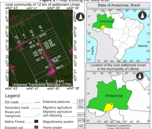
The study was performed in the rural community of 12 km of settlement Umari (64º40’14.4” and 64º34’26.0” W, 07º21'16.5” and 07º18’06.4” S) is located in the municipality of Lábrea, state of Amazonas, Amazon (Figure 1). Covering 90.171 km², the settlement established in 1996 by the National Institute of Colonization and Agrarian Reform (INCRA) is home to 158 families (INCRA, 2007).
River Paciá flows across rural settlement Umari, along equatorial forested lowlands in southern Amazon. Climate in the region is equatorial wet, regulated by the equatorial continental mass (ECM). This presents a dry season that lasts from May to September and rainy season between January and March being January the month of larger indexes pluviometric (350mm). April and October are transition periods, and mean annual temperatures between 21,3ºC and 31,5ºC (MENDONÇA and DANNI-OLIVEIRA, 2007).
Land-cover in the rural community of 12 km of settlement Umari is of two main types, namely the original forest (formed by rainforest evergreen amazonian of the lowland and rainforest evergreen Amazonian of holm), and agricultural and agroforestry cultivated covers. These systems occur on red and red-to-yellow clay-like, naturally dystrophic acrisols (V<50%) (IBGE, 2012; LINHARES et al., 2014).
Figure 1 – Map showing the study area.
Source – Geographic Database (GDB) of municipal information base of natural resources of the Amazon Protection System – SIPAM
.
METHODOLOGY
A map of soil use in the region was prepared based on survey data published by Linhares et al. (2014). The map on a 1:100 000 scale was prepared using a digital chart (SB.20-Y-C-IV, DSG, IBGE) and drainage, road, rural property, and altitude vectors (IBGE, 1982) complemented with
Caminhos de Geografia Uberlândia-MG v. 20, n. 71 Setembro/2019 p.160-181 Página 164 a satellite image (LANDSMAT 8/TM, 233/65, 30 x 30 m spatial resolution. All geographic information was processes in the software SIG SPRING 5.2 (INPE, 2015).
Based on the soil and land use map, one 50 m x 50 m quadrat was defined in each AFS (FURLAN, 2008). In total, 23 quadrats were established, as follows: 10 in AFSs, eight in shifting agriculture areas, two in pastures, and three in native forests (controls) . Quadrats were marked with PVC tubes, numbered, and georeferenced by global positioning system (GPS).
Three soil monoliths (two measuring 0.50 m x 0.50 m and one measuring 0.25 x 0.25 m, all 0.20 m deep) were obtained according to Moreira et al. (2010). A 500-g parcel was retrieved from each monolith to determine levels of total Hg (THg) and physical-chemical characteristics. All in all, 232 samples were obtained (116 between the 0 cm - 10 cm layer and 116 between the 10 cm - 20 cm layer). A 100-g aliquot was obtained from each sample and weighed. Clods were broken, and the material was sifted and homogenized to obtain a compound sample, as established by Brazilian environmental authorities (BRASIL, 2009).
All samples were transferred to plastic bags, labeled, and transported to a refrigerated environment in the Environmental Biochemistry Laboratory, Federal University of Rondônia (UNIR), where THg levels were analyzed.
Description of the experimental area
The potential of Hg as indicator of environmental changes and soil quality due LUCC was analyzed based on collecting soil samples in different land use classes (In total, 11) located in the rural community of 12 km of settlement Umari. The record of land uses in these parcels follows described realized by Linhares et al. (2016):
a) Native forest (NF): native vegetation typical of the southern Amazon forest classified as open lowlands with palms. Three conservation areas were used, one covering 300 hectares (NF45) and two covering 80 hectares (NF1 and NF44). The is no record of deforestation or wood extraction in these areas, which were likewise never used to grow plants using synthetic fertilizers or agrochemicals. Therefore, the quadrats in NF1 and NF45 were considered control areas.
b) Extensive pasture (EP8): pasture formed by Brachiaria brizantha cv. Marandu eight years before, after slash and burn of the native vegetation, in 2007.
c) Extensive pasture (EP12): identical record as the previous parcel, though the plant species Brachiaria brizantha cv. Marandu was established in 2003. In 2010, the pasture was renovated by slashing, though with no burning of woody weed species.
d) Temporary mechanized agriculture (Tma): the native vegetation was removed during the 2011 drought using a bulldozer. At that time, the land was ploughed and harrowed. Then, crushed leaves of manioc (Manihot esculenta Crantz) were spread. The area was left to fallow in 2015.
e) Migratory agriculture (Ma): the native vegetation was recently slashed and burned. Next, crushed leaves of manioc spread (first slash and burn cycle) to produce manioc flour. f) Migratory agriculture with 13-year fallowing (Ma13): the forest was converted into a M. esculenta plantation. The first cycle was between 1997 and 2001. After the last harvest, the area was left to fallow from 2001 to 2014, when the secondary forest was felled and burned to start the second manioc plantation.
g) Agroforestry system (AFS3): in 2011, the forest was modified with the establishment of a manioc plantation. Pineapple (Ananas comosus) was grown in the spacings. When M. esculenta reached 1 m, trees of the families Sterculiaceae (Theobroma grandiflorum Schum,
Caminhos de Geografia Uberlândia-MG v. 20, n. 71 Setembro/2019 p.160-181 Página 165 Theobroma Cacao L.), Lecythidaceae (Bertholletia. excelsa) and Arececeae (Astrocaryum aculeatum G. F W Meyer and Euterpe oleracea Martius, etc.) were planted.
h) Home garden (HG15): the forest was modified to grow manioc in the first year (1999). In 2000, the manioc plantation was converted to a home garden with the introduction of the first individuals of trees of the family Sterculiaceae (Theobroma grandiflorum Schum, Theobroma cacao L.), Lecythidaceae (Bertholletia. excelsa Humb), Meliaceae (Carapa guianensis Aubl.), Arecaceae (Astrocaryum aculeatum G. F W Meyer, and Euterpe oleracea Martius, etc.). limestone was used to correct acidity of the soil before the establishment of the home garden. i) Nineteen-year agroforestry system (AFS19): identical record as the previous system. The annual species grown were M. esculenta and Zea mays, which have been cultivated for two years. Next, the M. esculenta plantation was converted in agroforestry system with the establishment of tree species of the families Lecythidaceae (Bertholletia. excelsa Humb), Sterculiaceae (Theobroma grandiflorum Schum, Theobroma cacao L.), Arecaceae (Astrocaryum aculeatum G. F W Meyer, and Euterpe oleracea Martius).
Besides the quadrats described above, 12 other quadrats were included, of which seven were AFSs established in rural settlement Umari, like HG35, HG35a, HG39, HG55a, HG56a, HG56, and HG60 and five were migratory agriculture (Ma61, Ma58, Ma33, Ma55, and Ma59; the superscript number indicates the code of lots in the INCRA system), totaling 23 quadrats. Land use conversion record of all quadrats was similar to what was observed for SAF19, HG15, and Ma (LINHARES et al., 2016).
Physical and chemical characteristics of the soil
The soil was characterized based on the concentrations of aluminum (Al), calcium (Ca), magnesium (Mg), potassium (K), phosphor (P), iron (Fe), and acidity measured in pH / H2O (pHw) (EMBRAPA, 1997). Organic matter (OM) was determined using air-dried fine soil (ADFS) and titration with ammonium iron(II) sulfate. Levels of OM were calculated using the equation CO = (40 – volume spent) x f x 0.6, and OM = C x 1,72, with f = 40/volume of ammonium iron(II) sulfate spent in the blank assay (MENDONÇA, 2005). Grain size distribution was obtained by total dispersion. ADSF samples were kept in the desiccator until reaching the room temperature. Next, they were weighed (0.0001 g for clay). The sand fraction (coarse plus thin) was separated by sieving (0.2 mm; #70), while the silt fraction was determined by difference (LINHARES et al., 2016).
Hg levels in soil
THg levels were determined according to Bastos et al. (1998). Soil samples were wet-sieved to a 200 mesh (< 74 mesh). After drying in stove at 50ºC, samples were macerated in mortar and pestle. Next, approximately 0.500 mg of macerated soil was transferred to a test tube and solubilized with nitric acid and hydrochloric acid. Titration with potassium permanganate ensued (6 mL). Samples were heated for 30 min during the two acidification stages and then left to rest for 12 h. After, the solutions were reduced with hydroxylamine hydrochloride to an approximate ratio of 1 mL, when purple tips to clear. Immediately after, samples were shaken and filtrated by gravity in cellulose filters (Whatman®) in a 15-mL falcon tube to a final volume of 12 mL.
Hg levels in soil samples were determined by cold vapor atomic spectrometry (Flow Injection Mercury System, FIMS, 400, Perkin-Elmer). Calibration indicated recovery of 95%. Data of Hg levels were processed in the software Winlab, Perkin Elmer. All analyses were carried out in duplicate, with control blanks and certified samples (SS/2/140-025-002-SCP Science) to ensure analytical quality.
Caminhos de Geografia Uberlândia-MG v. 20, n. 71 Setembro/2019 p.160-181 Página 166
Spatial analysis
The statistical design to analyze levels of Hg and determine the physical and chemical attributes of soils was totally randomized. These variables were analyzed in four stages. The first was the organization of data, when the main module of the TerraView 4.2 geographic information system was used to generate a geographic databank (MySQL server) and the AR Umari AM project. Next, the study area was delimited using the Universal Transverse Mercator (UTM) conformal projection (UTM/zone 20) combined with the Geocentric Reference System for the Americas Datum/SIRGAS2000.
During the import of the digital base map of AR Umari AM using the theme/view tool, five information plans (PIs) in the format SHAPFILE (SHP) were defined in connection to the following variables: Hg, OM, physical attributes (PHA), chemical attributes (CHA), and study area (STDA). By default, each area (theme class = parcel, or experimental unit) was given an identification (ID) organized as a table of alphanumerical attributes containing 23 lines representing each experimental unit. Next, for all PIs, a column was added to the soil attributes described above.
In the second stage, after input of physical and chemical variables in the tables of each view/theme (PIs) of TerraView 4.2.2, global Moran’s I (Im) and local Moran’s I (Li, or Lisa), described by Anselin (1995) were generated. In the view tree (PIs), the view of interest and the table of events (soil variable) were selected. Next, the option statistical analysis of Im and Li (significance at p-value ≤ 0.05) was selected on the menu. By default, seven new columns for the global Moran’s I and local Moran’s I were added. The spatial representation of the local index (map of clusters of concentration of soil attributes) was analyzed using the interpolation algorithm of the quantic function, density calculation. These procedures afforded to generate a set of map of three-dimensional matrix cell for all parameters evaluated.
In the third stage, the mapped representation of soil parameters was exported in the GEOTIFF format to SIG/SPRING 5.2. The maps of the concentration of physical and chemical variables of the soil were prepared by inspection of the screen, based on the overlapping of information contained in the three-dimensional cell array (tones 0 - 255/dark grey > Hg levels, and light grey < Hg levels, which were associated by automatic processing to five vectors classes of concentration (very low, low, medium, high and very high), defined in the model of theme data. Based on Anselin (1995) and Medeiros et al. (2015), the criteria to interpret local spatial autocorrelation indices were defined for Hg levels and physical and chemical characteristics of soils. Six autocorrelation or spatial dependence classes were defined in the mapping of geographic phenomena. The indices or levels of spatial dependence are shown in Table 1.
Table 1 – Criteria of spatial interpretation of physical and chemical characteristics of the soil.
Spatial autocorrelation
index Intervals of values
Classes of levels of physical and chemical attributes of the
soil
Zero Li or SCI = 0 Zero
Minimal 0 > SCI ≤ 0.089 Very low
Weak 0.089 > SCI ≤ 0.174 Low
Moderate 0.174 > SCI ≤ 0.545 Medium
Strong 0.545 > SCI ≤ 0.745 High
Perfect 0.745 > Very high
Note – Li or SCI local spatial correlation indices is significant when p-v ≤ 0.05. Source:
Caminhos de Geografia Uberlândia-MG v. 20, n. 71 Setembro/2019 p.160-181 Página 167 In the fourth stage of analysis, the physical and chemical parameters organized as tables of SIG/Terraview values were organized as a single spreadsheet, which was exported as a xls file to the software Past version 3.0. This software was used to carry out the descriptive statistical analysis (mean, median, analysis of variance, standard deviation, coefficient of variation, etc.) and the Tukey mean (α = 0.05) in the classification of the variation of soil attributes. Person correlation coefficients were calculated for the values of texture, pHw, OM, total exchangeable bases (V%) as well as Al and Hg levels.
RESULTS
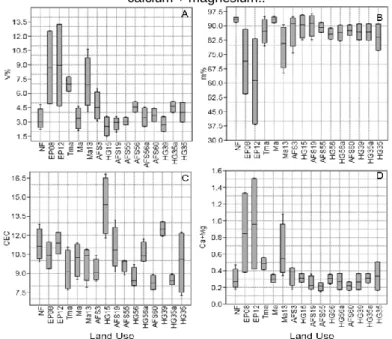
Percent base saturation of all categories and classes of land use were below 50%, indicating the dystrophic character of the soil in rural settlement Umari. However, the cation exchange capacity (CEC) was low in the soil collected in AFS60 (3.44 cmolc/dm³), average in soils in NF, PE08, Tma, Ma, Ma13, AFS3, AFS19, HG55, HG56, HG56a, HG35, and HG35a (between 7.91 cmolc/dm³ a 11.18 cmolc/dm³), and high in soils in HG39, HG15, and EP12, where CEC was always below 11.30 cmolc/dm³ (Figure 2). Oppositely, Al saturation (%) values were higher than 80% for soils in AFSs, Ma, Tma, and NF. In soils EP08, EP13, and Tma13 these values were between 61.33% and 77.91%. The high saturation of Al explains the alic character and the low base saturation in soils of rural community of 12 km of settlement Umari.
The soil of all land use class assessed presented high acidity (mean pHw = 4,1). Acidity the below the average of the area of NF, control area was observed in the soil under HG15, HG39 and HG55 (3,85, 3,95 e 3,80, respectively). This may be associated with the high levels of OM in HG15, HG39 and HG55, which had been established for over 10 years (LINHARES et al., 2016).
The sandy loam and sandy clay textures of samples prevailed in all categories of soil use and cover. The results of the analysis of variance indicate no statistically significant differences in levels of clay, silt, sand. In other words, texture composition of soils in AFSs, migratory agriculture with or without fallowing, cattle farming, and native forest did not vary significantly. This suggests the hypothesis that the experimental units were established on the same soil class.
Figure 2 – Mean of chemical attributes in the 0 - 20 cm layer soil under different land use / cover. A.
Base saturation (V%); B. Aluminum saturation (m%). C.Cation exchange capacity (CEC). D. sum calcium + magnesium..
Caminhos de Geografia Uberlândia-MG v. 20, n. 71 Setembro/2019 p.160-181 Página 168
Note – Native forest (NF), cattle farming (EP), mechanized agriculture (Tma), migratory agriculture (Ma),
migratory agriculture with 13-year fallowing (Ma13), agroforestry systems (AFSs) established for 3, 15, and 19 years, home garden (HG56a) established for over 10 years. (CEC = cmolc/dm³). Aluminum saturation (m%).calcium + magnesium (Ca+Mg = cmolc/dm³).
Hg levels in soil in different soil use and cover systems
The modification of forest cover (NF) based on migratory agriculture (Ma) or slash and burn, which is used to clear the land used to grow manioc, is one of the activities that promotes the remobilization of Hg to the atmosphere in rural environments in southern Amazon. Subsequently, the Hg remobilized is incorporated by other natural cultivation systems by wet deposition. Mean Hg levels in the 0 – 10 cm layer under Ma varied between 87 ng/g and 121 ng/g, confirming this trend. On the other hand, Hg levels were high in the 10 – 20 cm layer in all soil samples in Ma, with mean values between 103 ng/g and 258.25 ng/g.
In the land use system with no biomass burn or harrowing, Hg levels varied between 55 ng/g (0 – 10 cm) in pastures and 317 ng/g and 327 ng/g in native forest and in agroforestry home garden established for 15 years (HG15). Also, Hg levels in pasture (EP12) and forest (NF1, NF44, and NF45) were similar to values obtained in other studies in the Amazon.(ALMEIDA et al., 2005; HERMANN et al., 2009; LACERDA et al., 2012)
The Hg levels in soils had strong negative correlation with pH (r = -0.88) in the 0 – 10 cm layer, moderate negative correlation with the parameter (r = -0.64) in the 10 – 20 cm layer. Hg levels had moderate positive correlation with clay (r = -0.47) and moderate negative correlation with silt (r = 0.68) in the 0 – 10 cm layer. Also, Hg levels had weak positive correlation with sand (Table 2). Similar behavior was observed for Fe levels, with significant negative correlation (p < 0.05) with Hg levels, CEC, and clay, and positive correlation with pH. High acidity and low silt/clay ratio (r = 0.64 in the 0 – 10 cm layer and r = 0.71 in the 10 – 20 cm layer), which prevailed in all soil samples, indicate that the red acrisol is under strong weathering effect in the area studied.
It was expected that the soil in the native forest in the rural community of 12 km of settlement Umari presented Hg levels above the values observed for the other systems at all periods and layers, since soils under natural vegetation tend to be exposed to less disturbance compared with cultivated systems.
Table 2 – Pearson correlation coefficient of the physical and chemical characteristics soil in the 0–10
cm layer in the rural community of 12 km of settlement Umari, Amazon, Brazil.
Attributes Hg pHw CEC Clay Silt Sand OM Al Fe
Hg 1.00 pH /H2O -0.88* 1.00 CEC 0.59 -0.54 1.00 Clay 0.47* -0.59 0.66* 1.00 Silt -0.68* 0.63 -0.23 -0.09 1.00 Sand 0.11 0.00 -0.35 -0.71 -0.63 1.00 OM 0.40 -0.31 0.91* 0.40 -0.00 -0.30 1.00 Al 0.07 -0.11 -0.39 -0.45 -0.06 0.40 -0.27 1.00 Fe -0.80* 0.80* -0.76* -0.80* 0.24 0.45 -0.58 0.13 1.00
Note – Acidity measured in pH / H2O (pHw), cation exchange capacity (CEC), clay, silt, and sand (g/kg), organic matter (OM), Al (cmolc/dm³), Fe (mg/dm³), *significant correlation with 95% confidence in the Tukey test (p < 0.05).
Nevertheless, the soils of home gardens HG15, HG39, and HG35ahad mean Hg levels above the values recorded for the 0 – 20 cm layer in the dry and rainy seasons (Figure 3).
Caminhos de Geografia Uberlândia-MG v. 20, n. 71 Setembro/2019 p.160-181 Página 169
Figure 3 – Levels of soil Hg concentrations in land use/cover classes at different seasons. A. Hg
concentrations in the 0 – 10 cm layer in the dry and rainy seasons; B. Hg concentrations in the 10 – 20 cm layer in the dry and rainy seasons.
Note – Native forest (NF), agroforestry systems (AFSs) established for 3, 15, and 19 years with home
garden (HG15, HG35, HG35a, HG39,HG56 and HG56a) established for over 10 years.
Higher levels of Hg accumulated in NF, HG, and AFS. Approximately 84% of samples collected in the dry season and 92% of those obtained in the rainy season had Hg levels above 50 ng/g. However, these values did not exceed the maximum prevention value of 500 ng/g for agricultural areas defined by Brazilian environmental authorities (BRASIL, 2009).
Hg levels in the 0 – 10 cm layer in the dry and rainy seasons in HG56 and HG56a were below quality reference values (BRASIL, 2009). The more marked topographic gradient may promote the leaching of Hg in clay to small water bodies that flow across in rural community of 12 km of settlement Umari (ALMEIDA et al., 2005).
Based on the local spatial autocorrelation analysis (Li) it was possible to observe that it varied from perfect to strongly positive direct, with significance level below 5% (p < 0.05) for Hg levels in quadrats in AFS3, HG35a and HG56ain the 0 – 10 cm and 10 – 20 cm layers in the dry and rainy seasons. Similar results were observed for mean Hg levels in the 0 – 20 cm layer in quadrats in HG39, HG35a, HG56a(dry season) and HG35a (rainy season) wit > confidence level > 5% (Table 3).
Table 3 – Local spatial variability of Hg levels in the 0 – 10 cm and 10 – 20 cm layers
different land uses.
System Spatial analysis
Hg Li. Hg Li
0 - 10 cm dry period 0-10 cm rainy period
NF01 119 -0.7210 242 -0.5600
NF44 200 0.1987 200 -0.07210
Caminhos de Geografia Uberlândia-MG v. 20, n. 71 Setembro/2019 p.160-181 Página 170 EP8 62 0.04185 - - EP12 48 -0.5059 - - Tma 68 -0.0410 105 -0.0569 Ma 86 -0.1214 124 -0.0887 Ma13 90 -0.4029 - - AFS3 184 1.7342** 224 1.7524** HG15 219 -0.6231 292 -1.0455 AFS19 100 -0.1083 117 -0.0346 AFS55 127 -0.0494 78 -0.01340 HG56 37 0.02596 38 -0.0041 HG56a 33 -0.1140 109 0.2167 AFS60 73 -0.0599 72 0.0039 HG39 212 -1.7410* 228 -1.4907* HG35a 126 -0.5506 131 0.01351 HG35 140 0.4384 104 0.4657**
10 – 20 cm dry period 10 – 20 cm rainy period
NF01 158 -0.7949* 215 -1.2780 NF44 150 -0.1611 194 -0.3323 NF45 239 0.2522 137 0.2029 EP8 77 0.04856 - - EP12 118 0.0345 - - Tma 89 -0.0630 112 -0.0707 Ma 66 0.0086 138 -0.1752 Ma13 159 -08039 - - AFS3 85 0.1206 160 0.6762 HG15 327 -1.2643 308 -0.7966 AFS19 190 0.03602 100 0.1110 AFS55 121 -0.2129 94 0.0551 HG56 87 0.0170 113 0.03417 HG56a 146 0.5747 114 05818* AFS60 112 -0.1688 64 0.0009 HG39 225 -1.3967* 238 -1.4683* HG35a 235 0.0751 197 0.2131 HG35 126 0.5880** 148 0.8654**
Note – Native forest (NF), extensive pasture (EP), Temporary mechanized agriculture (Tma), migratory agriculture with 13-year fallowing (Ma13), agroforestry systems (AFSs) established for 3, 15, and 19 years, home garden (HG56a) established for over 10 years. Local spatial correlation index (Li or SCI). SCI or Li significant when p < 0.05. (*) Significance and cartographic representation when p ≤ 0.001 (**). Hg levels in soil in NF1 and HG39were different (except in the 0 – 20 layer), which presented perfect negative spatial indirect correlation, with significance level of zero (p = 0) in the 0 – 10 cm layer and in the 10 – 20 cm layer in both seasons. This confidence level indicates that Hg concentrations in these land use and cover classes tended towards independence, just like the
Caminhos de Geografia Uberlândia-MG v. 20, n. 71 Setembro/2019 p.160-181 Página 171 Hg concentrations in Ma13 in the 0 – 20 cm layer in the dry season, which varied from minimal to perfect negative and positive correlation with significance level > 5% for Hg levels in soil. The cluster maps of Hg levels (Figure 3) generated using local Moran’s i (Li or SCI) afforded to identify the formation of two distinct areas concerning the distribution and spatial variability of Hg levels in the soil samples in the 0 – 10 cm layer. Area A1 is formed by clusters with perfect significant SCI (p ≤ 0.05) for Hg levels in AFS3.
Figure 3 – Spatial variability of soil Hg levels at different land use and years seasons. A. Hg levels in
the 0 – 10 cm, 10 – 20 cm and 0 – 20 cm layers in the dry seasons. .B. Hg levels 0 – 10 cm and 10 – 20 cm .layers in the rainy seasons.
This area is associated with areas of strong spatial correlation for Hg concentration, concentrating in the native forest fragments (NF44 and NF45) and AFS19, though with
Caminhos de Geografia Uberlândia-MG v. 20, n. 71 Setembro/2019 p.160-181 Página 172 significance over 5% (p > 0.05). At the ends of A1, SCI was minimal for Hg concentrations in migratory agriculture (Ma) and temporary mechanized agriculture (Tma).The second area (A2) was formed by clusters with perfect spatial local correlation indices for Hg levels in soil in HG39. Nevertheless, confidence level was zero (p = 0). This means that Hg concentration in this soil tends to spatial Independence, with significance in spatial representation of Hg concentration < 0.001. HG15, AFS19, HG55, and HG35a are included in this cluster, with SCI of Hg levels in soil varying from perfect to minimal, all with confidence levels > 5% (p > 0.05).
The interpolation of spatial association coefficients (Li or SCI Moran’s) of Hg levels in soil collected in the dry season (Figure 3 A) obtained for the 0 – 10 cm and 10 – 20 cm layers with different land use/cover presented a similar pattern of spatial distribution for the variable Hg, observed in the rainy season (Figure 3 B). However, the maps of clusters prepared using mean Hg levels in soil in the 0 – 20 cm layer had distinct spatial patterns, with three categories (NF, Ma, and AFS) and five classes of landl use/cover (areas or polygons) with spatial correlation varying from perfect to moderate in the dry season (Figure 3A).
DISCUSSION
Lucc and retention of Hg in soil
The change from NF to migratory agriculture with or without fallowing (Ma and Ma13), temporary mechanized agriculture (Tma), and pastures (EP08 and EP12) for extensive cattle farming reduce levels of OM and Hg in soil. On the other hand, the change in the use of soil from migratory agriculture (Ma) for agroforestry systems (HG15, HG35a, HG35, AFS19, and HG39) represented an increase in OM in soil, CEC, and Hg concentration. These results show that the indicators of soil quality may differ significantly in time and space when the change in land use takes place by conversion and/or modification (Figure 4).
Concerning the effective time needed for the soil to recover its ecological functions, the agroforestry systems established for more than 10 years in rural community of 12 km of settlement Umari had significant resilience capacity and Hg retention capacity, especially in the soils in HG15, HG35a, HG35, and HG39. A similar Hg retention pattern was observed for AFS3, where migratory agriculture had been replaced by AFS for three years.
The soils where migratory agriculture was practiced (Ma) presented Hg levels below those observed for NF in the 0 – 10 cm layer (Figure 4). The low concentration of Hg in the soil in quadrats in Ma is associated with two factors. Firstly, the high temperature (> 60º C) observed during biomass burning enabled the volatilization of Hg contained in litterfall and on the surface layer of soil (MELENDEZ-PEREZ et al., 2014). Secondly, with the loss of forest cover, the soil was exposed to the kinetic effect of raindrops, which promoted the erosion of the fine fraction (clay) of the soil, where Hg is adsorbed more efficiently. Comparable results were obtained by Mainvelle et al. (2006) in a study that investigated the effect of the change in land use on Hg distribution in soil of the Peruvian Amazon. Also, Lacerda et al. (2012) claimed that the slash and burn of primary vegetation to establish subsistence agriculture areas is the main aspect behind the remobilization of Hg to the atmosphere as well as the aquatic and terrestrial environments of the tropical Amazon.
It was expected that Hg levels in the soil (in the 0 – 10 cm layer) in the areas with migratory agriculture with fallowing (Ma13), after the regeneration of the secondary vegetation would be accompanied by OM and Hg levels that are similar to the values observed in native forest (NF) and agroforestry systems (AFSs) established for more than 10 years.(GRIGAL et al.,1994; BÉLISVEAU et al., 2009; COMTE et al., 2013). Nevertheless, no significant Hg accumulation was observed in soil with migratory agriculture, even 13 years into fallowing.
In Ma13, mean Hg concentration before sample collection in August 2014 (138 ng/g ± 10.03) and after the slash and burn of the secondary vegetation (124.25 ng/g ± 40.75), which emerged 13 years into fallowing was of the same order of magnitude. On the other hand, higher mean Hg
Caminhos de Geografia Uberlândia-MG v. 20, n. 71 Setembro/2019 p.160-181 Página 173 levels in the 10 – 20 cm layer were observed after the second growth of M. esculenta (beginning of August 2015).
Figure 4 – Concentration of Hg in a time sequence of native forest (NF), migratory agriculture (Ma), and
agroforestry home garden (HG) established for aver 10 years.
Note – Native forest (NF), extensive pasture (EP), mechanized agriculture (Tma), migratory agriculture
with 13-year fallowing (Ma13), agroforestry systems (AFSs) established for 10 and 19 years, home garden (HG15, HG35a, HG35, HG39, HG55, HG56 and HG56a,) established for over 10 years.
In this sense, Grigal et al. (1994) investigated the pattern of Hg distribution in different pedo-geomorphologic environments and land use in the rural area of the municipality of Anoka, Minnesota, USA. The authors observed that the curve of exponential increase of OM in soil and of Hg complexed to OM stabilized after 70 years of fallowing. This contribution enables concluding that the history of land use, the process of change of land cover and the effective resilience time of the plant cover, whether spontaneous or cultivated, affect the quality of soil and the capacity of accumulation and retention of OM and Hg in the tropical soil.
The low level of clay in the surface layer of red acrisol and red to yellow acrisol and the prevalence of loam to clay-sand texture and clay-sand texture reduced the surface available to adsorb Hg that reached the soil with no natural or cultivated land cover. It is possible that, during the first rains in the rainy season in southern Amazon, Hg from dry deposition was percolated to the subsurface layer (10 – 20 cm) in Ma13.
The conversion of the migratory agriculture area to agroforestry system (AFS) in the rural settlement Umari, where soil was managed based on the absence of biomass burning, recovered the capacity of AFS soil to retain higher levels of OM and Hg more efficiently than the soil with migratory agriculture with and without fallowing. Concerning the retention of Hg in AFS soil, Tagliari (2009) to the assess the soil loss and Hg in different land use classes in the microregion of the low Tapajós River (state Pará) observed high loss of soil and Hg in area of
Caminhos de Geografia Uberlândia-MG v. 20, n. 71 Setembro/2019 p.160-181 Página 174 migratory agriculture, bushland, and pasture of 27.6 kg Hg/ha/year, while in NF and AFS the value was 1.00 kg Hg/ha/year.
The replacement of slash and burn and of the farming of manioc by perennial woody tree and bush species of the families Steculiaceae (Theobroma cacao and T. gradiflorum Schum), Meliaceae (Carapa guianensis Aubl.) and Lecythidaceae (Bertholletia excelsa Humb.), which are deciduous or semideciduous, formed a thin layer of litterfall that nevertheless was thick enough to incorporate OM in soil and retain Hg from dry deposition (gaseous Hg and particulate Hg adsorbed and absorbed by leaf tissue) and wet deposition (throughfall and Hg precipitating directly on the soil with rain) (TEIXEIRA et al., 2012).
Temporal-spatial dynamic of Hg in agroforestry systems
Local spatial correlation (Moran’s Li) of OM and Hg levels in HG35a, HG35,HG39,HG56a, and HG56, all established for over 10 years. Intrinsic and extrinsic pedogenetic factors induced the increase in Hg and OM levels in the 0 – 20 cm layer in AFSs. However, extrinsic factors of soil like anthropic (activities associated with cultivation like fertilization, liming, management and land use/cover ,agricultural vehicle traffic, conversion of land-use/ cover, and others) induced the highest retention of OM and Hg in southern Amazon. In other words, soils in AFSs established for over 10 years by settlers in rural community of 12 km of settlement Umari have high potential to work as Hg and carbon (C) sink, despite the differences associated with pest management, maintenance of AFS, and production logistics.
The variations in Hg levels on the interface between litterfall and soil were investigated in studies carried out in Brazil as well as other countries (ROULET et al., 1999; SILVA et al., 2009; GAMBY et al., 2015). In this context, recently Melendez-Peres (2013) evaluated Hg emissions from forest burning in another state in the Amazon (Acre) and concluded that litterfall accounts for 10% of the biomass of the native forest under the soil. The total burning of this amount of biomass represents the remobilization of 92% of the Hg in the soil-litterfall compartment to the atmosphere. Similarly, agroforestry systems are agroecosystems whose ecological features and functions are similar to those observed for a primary forest (MENEZES et al., 2008; RODRIGUEZ, 2015).
Therefore, Hg levels in litterfall and soil of AFSs in rural settlement Umari were proportional to the levels observed in the interface between litterfall and soil in the native forest of southern Amazon used as reference (SILVA et al., 2012). This distribution pattern was observed in HG15, HG35a, and HG39, where Hg levels in soil were statistically identical to values observed for NF.
In the spatial analysis (local Moran’s Li), by default, omits outliers too distant from the vector mean, with or without significance (p > or < 0.05). This is the case of the soil in AFS3, AFS≥1060, AFS19, and HG15. For this reason, these values should be evaluated in depth concerning the seasonal behavior of Hg levels in these land use and cover systems.
It was expected that AFS3 established for three years only had Hg levels in the 0 – 20 cm layer in the rainy and dry seasons lower than those observed for NF and AFSs established for longer times. However, contrasting with the logical Hg geochemical cycle in recently deforested and burned soil, Hg levels in AFS3 differed little from the values observed in NF; however, they were almost twice as high as those recorded for AFS19.
It is possible that the biomass produced and the complex root system of Imperata brasiliensis Trin (Brazilian satintail) played a protective role in soil against external agents (rain, temperature and runoff) that are active on soil aggregates (sand, silt, and clay) (MASCARENHAS et al., 1999). In addition, the loam, clay and sandy texture of the soil, the lanes established in the cultivation of A. cosmosus and M. esculenta Crantz (Figure 5) increased the percolation of water and humic organic compounds, when Hg is adsorbed and dissolved by geophysical-chemical bonds.
Caminhos de Geografia Uberlândia-MG v. 20, n. 71 Setembro/2019 p.160-181 Página 175 Mean Hg levels in AFS3 (0 – 10 cm layer) presented contrasting behavior compared with the soil in AFS19, established for longer. Oppositely, significant Hg levels were observed in the 10 – 20 cm layer in the dry and rainy seasons (except in AFS19) in home gardens established for more than 10 years, though values differed little when compared with those recorded in NF. It is important to mention that all agroforestry systems (AFS19, AFS60,and HG15) investigated in rural settlement Umari were implemented in small farms, where the forest was removed to introduce subsistence agriculture that subsequently was converted in AFS in the late 1990s, more precisely from 1997 on. This period coincides with the marked decrease in gold mining and, therefore, in the emission of Hg in the Amazon (BASTOS e LACERDA, 2004; LACERDA et al., 2012).
Figure 5 – Area of migratory agriculture in the rural community of 12 km of settlement Umari. (A) Partial
view of the cultivation of A. cosmosus, (B) M. esculenta Crantz plantation overwhelmed by Imperata
braziliensis Trin
.
Source – Authors
Mean Hg levels in AFS≥1060in the 0 – 10 cm layer both in the rainy and dry seasons were 72 ng/g and 73 ng/g, respectively. These numbers are similar to the values observed for pastures established by Brachiaria brizantha. Nevertheless, mean Hg levels were lower (64 ng/g) in the 10 – 20 cm layer in the rainy season, while a mildly higher value was observed in the rainy season (112 ng/g).
The decrease in Hg levels in soil in AFS60may be associated with three main factors. The first is the morphology and the longer lifespan of leaf tissues of the species Euterpe precatória and Theobroma grandiflorrum Schum, which afforded a lower amount of plant material, reducing the incorporation of OM and Hg complexed in it. The second is the absence of large volumes of litterfall under the soil in AFS60, which reduced biological activity of detritivore and saprophagous organisms with active roles in soil aeration and fragmentation and decomposition of fresh OM and several chemical species (such as those of Hg) bound to OM in the soil (TAPIA-CORAL et al., 1999; SOUZA et al., 2014). The third is the periodical removal of dead leaves and branches and wood bits in AFS60by settlers in order to produce organic fertilizer based on OM that is burnt or buried for a given period of time and to clear prospective cultivation areas, interrupting the formation of litterfall and, as a result, blocking the transfer of organic substances and Hg to the soil in AFS60. This may be the reason behind the decrease in Hg levels in soil in AFS60, since litterfall is one of the main Hg deposits in the environment in southern Amazon.
The factors that influence the levels of Hg in soil in AFS19 are similar to those observed in AFS60, except for the absence of litterfall, which was not removed by settlers in the area during the study period. So, Hg levels in the 0 – 10 cm and 10 – 20 cm layers in the dry season (100
Caminhos de Geografia Uberlândia-MG v. 20, n. 71 Setembro/2019 p.160-181 Página 176 ng/g and 190 ng/g, respectively) and rainy season (16 ng/g and 99 ng/g, in that order) were higher than the values observed for AFS60.
The biogeochemical and pedobiological variables observed indicate that HG15 is a peculiar site for analysis in the Area. Mean Hg levels in the rainy and dry seasons (273 ng/g and 300 ng/g, respectively) were higher than the values recorded for the control area (NF).
The difference between HG15 and the other classes of land use in the AFS category concerning Hg levels (except AFS39) and other substances present in the soil compartment may be explained based on the high variety of tree species of families like Sterculiaceae, Lecythidaceae, Meliaceae, Myrtaceae, and Rubiaceae, which worked as a source of nutrition to a larger group of animal species with an active role in soil biology. Moreover, the presence of tree species such as Theobroma grandiflorum Schum, Bertholletia excelsa Humb, Carapa guianensis Aubl, and Syzygium malacense promoted the formation of a thicker, high quality layer of litterfall. In addition, the formation of a more open and layered canopy increases humidity and irradiance, which are dynamic bioclimatic elements with an essential part in the decomposition of OM.
This set of biogeographical factors favored the natural ecosystem in HG15 concerning the fixation of organic carbon, production of oxygen (aeration), and retention of Hg and organic and inorganic compounds (VENZZANI e MIELNICZUK, 2009; KORASAKI et al., 2013).
The pedogenetic and bioclimatic characteristics of the region studied promoted the development of a diversified community both above and below the soil level in quadrats in HG15, HG35a, and HG39. These factors enabled the recovery of the capacity to retain higher levels of OM and Hg compared with the levels recorded in NF (control area), migratory agriculture (Ma), and extensive pasture (EP) as well as the other agroforestry systems established more recently in rural settlement Umari.
The results of the analysis of Hg and OM levels confirm the hypothesis that AFSs established for 10 years or more induce the effective retention of OM and Hg. The local Moran correlation indices (Li or SCI) reveal the significance dependence of the spatial distribution pattern of these two indicators between a given class of land use (AFS and HG) and the neighboring areas (NF and Ma13).
CONCLUSION
In the second cycle of artisanal gold mining, the Hg was widely used in gold mining in the Amazon.
In this time and space, specialists in geochemistry that the levels of Hg detected in the Amazonian
ecosystem were associated to the release of Hg promoted by the artisanal gold mining.
With the depletion of the gold fields there was a significant reduction in all mining fronts of the Amazon basin. Proportions to the decline in gold production were the direct Hg releases in the Amazon environment. However, almost twenty years after the second gold cycle peak, distant locations of old mining areas in a remote region of the Amazon continue to have concentrations of
Hg in the soil higher than the reference value (140 ng g-1).
This alone prompts us to poder that Hg detected in the surface layer of the soil into different
categories of land use / cover in the rural community of 12 km of settlement Umari is originates of
their own substrate geologic region’s which originated the southern Amazon soils and mainly of the remobilization of Hg, originating from the burning of solid waste in the open sky, burning of fossil fuels and deforestation followed by burning of the biome for implantation of farming and pasture promoted in other regions of the country. In this case, the input of Hg (gaseous and particulate) in soil under NF, AFS, HG, EP, Ma, Ma13, and Tma in the study area has been occurring via wet and dry atmospheric deposition.
The levels of Hg used as indicators of environment changes and soil quality show that the removal of the native plant cover to establish migratory agriculture (manioc) show marked loss
Caminhos de Geografia Uberlândia-MG v. 20, n. 71 Setembro/2019 p.160-181 Página 177 of Hg. In other words, this trace metal was remobilized to the atmosphere and other ecosystems mainly through erosion. On the other hand, the Hg levels in soils in native forest (NF) allow concluding that this pedoenvironment works as a Hg sink. Therefore, a native forest is able to mitigate the release not only of CO2, but also of Hg to the atmosphere. Consequently, the remobilization of Hg from the atmosphere to other ecosystems is also reduced.
The results obtained show that the capacity of cultivated soils to stock Hg (both organic and inorganic) depends on the type of soil and morphological, physical, chemical, and biological attributes in addition to the kind of soil preparation and management of the crops grown. In other words, agricultural systems exposed to low intensity harrowing (AFS and HG) improve soil quality in the mid and long term.
The conversion of the migratory agriculture areas or those exposed to slash and burn practices in agroforestry systems increased the retention of Hg in soil in rural community of 12 km of settlement Umari. The results indicate that AFSs have increased potential to store Hg and mitigate the release of the metal in the soil of southern Amazon.
ACKNOWLEDGEMENTS
The authors are grateful to the organizations that financed this study, namely the Pró-Reitoria de Pesquisa, Pós-graduação e Inovação do Federal Institute of Education Science Technology of Amazon (IFAM) for the grants given (proc n. 23443.01588/2018-15) and the research groups in Laboratório de Biogeoquímica Ambiental Wolfgang C. Pheiffer (UNIR) and Desenvolvimento Regional do Médio Purus IFAM campus Lábrea.
REFERENCES
ALMEIDA, M. D. et al. Mercury loss soils following conversion from forest to pasture in Rondônia, Western Amazon, Brazil. Environmental pollution, n. 137, p. 179-186, 2005. https://doi.org/10.1016/j.envpol.2005.02.026
ANDRADE, T. O. GANIMI, R. N. Revolução verde e Apropriação capitalista. CES Revista, v. 21, p. 43-56, 2007.
ANSELIN, L. Local Indicators of Spatial Association. Geographical Analysis. v. 27, n. 2, p. 95-115, 1995.
https://doi.org/10.1111/j.1538-4632.1995.tb00338.x
ARAUJO, E. A. Qualidade do solo em ecossistema de mata nativa e pastagem na região leste do Estado do Acre. Tese (Doutorado em Ciências do Solo) - VIÇOSA: UFV. 2008.
ARAUJO, E. A.; KER, J. C.; NEVES, L. C. J.; LANI, J. L. Qualidade do solo: conceitos,
indicadores e avaliação. Revista de Pesquisa Aplicada & agrotecnologia, v. 5, n.1, p. 187-196, 2012.
https://doi.org/10.5777/PAeT.V5.N1.12
BASTOS, W. R. et al. Establishment and analytical quality control of laboratories for Hg determination in biological and geological samples in the Amazon-Brazil. Ciência & Cultura, v. 50, p. 255-260, 1998.
https://doi.org/10.1006/abio.1998.2705
BASTOS, W. R.; LACERDA, L. D. Contaminação por mercúrio na bacia do rio Madeira uma breve revisão. Revista Geochimica Brasiliensis, v.18, n. 2, p. 99-114, 2004.
Caminhos de Geografia Uberlândia-MG v. 20, n. 71 Setembro/2019 p.160-181 Página 178 of the primary forest, in the Brazilian Amazon. Science of the total Environment, n. 407, p. 4480-4489, 2009.
https://doi.org/10.1016/j.scitotenv.2009.04.012
___________ Reduction of soil erosion and mercury losses in agroforestry systems compared to forests and cultivated fields in the Brazilian Amazon. Journal of Environmental Management, n. 203, p. 522-532, 2017.
https://doi.org/10.1016/j.jenvman.2017.07.037
BRASIL. Conselho Nacional do Meio Ambiente - CONAMA. Resolução nº. 420 de 2009. Dispõe sobre os critérios e valores orientadores de qualidade do solo quanto à presença de substâncias químicas e estabelece diretrizes para o gerenciamento ambiental de área
contaminadas por essas substâncias em decorrência de atividades antrópicas. Disponível em: <http://www.mma.gov.br/port/conama/legiabre.cfm?codlegi=620>. Acesso em: 10 de julho de 2017.
BRIASSOULIS, H. Analysis of land use change: theoretical and modeling approaches. [S.I]: Web Book of Regional Science, 1999. Disponível em:
<http://www.rri.wvu.edu/WebBook/Briassoulis/contents.htm>. Acesso em: 03 de fevereiro de 2017.
CAMPOS, M. C. C. et al. Topossequência de solos na transição Campos Naturais-Floresta na região de Humaitá, Amazonas. Revista Acta Amazonica, v. 42, n. 3, p. 387-398, 2012.
https://doi.org/10.1590/S0044-59672012000300011
COMTE, I. et al. Impacts de land use on mercury retention in long-time cultivated soils, Brazilian Amazon. Water Air Soil Pollut, n. 224, p. 1-14, 2013.
https://doi.org/10.1007/s11270-013-1515-3
DORAN, J. W.; PARKIN, T. B. Defining and assessing soil quality. In: DORAN, J. W.; COLEMAN, D. C.; BEZDICEK, D. F.; STEWART, D. C. Defining soil quality for a sustainable environment. Madison Wisconsin: soil Science Society American, n. 35, p. 3-21, 1994. (Special Publication).
https://doi.org/10.2136/sssaspecpub35.c1
DORAN, J. W. Soil health and global sustainability: translating science into practice. Agriculture, Ecosystems and Environment, n. 88, p. 119-127, 2002.
https://doi.org/10.1016/S0167-8809(01)00246-8
EMBRAPA - Empresa Brasileira de Pesquisa Agropecuária . Manual de métodos de análise de solo. 2. ed. Rio de Janeiro: 1997. 212 p. (EMBRAPA-CNPS. Documentos 1).
ESCADA, M. I. S. Evolução de padrões da terra na região centro-norte de Rondônia. Tese (Doutorado em Sensoriamento Remoto) - São José dos Campos: INPE. 2003.
FURLAN, S. A. Técnicas de Biogeografia. In: VENTURI, L. A. Praticando Geografia Técnicas de campo e laboratório. São Paulo: Oficina de Textos, 2005. p. 99-30.
GAMBY, R. L. et al. Desforestation and cultivation mobilize mercury from topsoil. Science of the total environment, n. 532, p. 467-473, 2015.
https://doi.org/10.1016/j.scitotenv.2015.06.025
GRIGAL, D. F.; NATER, E. A.; HOMANN, P. S. Spatial distribution patterns of mercury in an east-central Minnesota Landscape. In: WATRAS, C.J.; HUCKBEE, J.M.; Mercury pollution
Caminhos de Geografia Uberlândia-MG v. 20, n. 71 Setembro/2019 p.160-181 Página 179 integration and synthesis. Louisiana (USA): Lewis publ., Boca Raton, 1994, p. 305-312.
HERRMANN, J. C. Mercúrio em solos da Sub-bacia do Rio Corumbiara/RO: análise do padrão espacial da dispersão. Tese (Doutorado em Geociência) - Rio Claro: UNESP. 2008.
IBGE - Instituto Brasileiro de Geografia e Estatística. Manual técnico da vegetação brasileira. 2. ed. Rio de Janeiro: IBGE, 2012.
INCRA - Instituto Nacional de Colonização e Reforma Agrária. Sistema de Informação de Projetos de Forma Agrária - SIPRA. Relatório de Assentamentos do Amazonas, 2007. Disponível em: <http://www.dpi.inpe.br/geopro/modelagem
/relatório_configuracoes_desflorestamento. pdf>. Acesso em: 26 de abril de 2019.
INPE - Instituto Nacional de Pesquisas Espaciais. SPRING: tutorial de geoprocessamento. Disponível em: <http://www.dpi.inpe.br/spring/portugues/tutorial/>. Acesso em: 25 de junho de 2015.
KORASAKI, V.; MORAIS, J. W.; BRAGA, R. F. Macrofauna. In: MOREIRA, F. M. S.; CARES, J. E. ZANEDA ALMEIDA, M. D. The impacts of land use changes in the mercury flux in the Madeira River, Western Amazon. Anais da academia brasileira de ciência, V. 8, n. 1, p. 69-78, 2012.
https://doi.org/10.1590/S0001-37652012000100007
LACERDA, L. D.; BASTOS, W. R.; ALMEIDA, M. D. The impacts of land use changes in the mercury flux in the Madeira River, Western Amazon. Anais da academia brasileira de ciência, V. 8, n. 1, p. 69-78, 2012.
https://doi.org/10.1590/S0001-37652012000100007
LAL, R.; PIERCE F. J. The vanishing resource. In: LAL, R.; PIERCE, F. J. Soil management for sustainability. Askeny: Soil Water Conservation Society, 1991.p.1 - 5.
LAMBIN, E. F.; GEIST, H. J.; LEPRS, E. Dynamics of land-use and land-cover changer in tropical regions. Annul Review of Environment and Resources, n. 28, p. 205-241, 2003. https://doi.org/10.1146/annurev.energy.28.050302.105459
LARSON, W. E; PIERCE, F. J. The dynamics of soil quality as a measure of sustainable Menagement. In: DORAN, J.W.;COLEMAN, D.C.; BEZDICEK, D.F; STEWAT, B.A. Defining soil quality for a sustainable environment. Madison, Wisconsin, USA: Soil Science Society American, n. 35, p.37-52, 1994.
LEPSCH, I. F. Solos: 19 lições de Pedologia. São Paulo: Oficina de texto, 2011. 456 p. LINHARES et al. Variabilidade de atributos físico-químicos e dos estoques de carbono orgânico em Argissolo Vermelho sob sistemas agroflorestais no assentamento Umari sul do Amazonas. Revista de Geografia Acadêmica, v. 10, n. 01, p. 93-116, 2016.
LINHARES, J. M. S. et al. Levantamento de solo em diferentes ambientes geomorfológicos e sistemas de uso da terra na microbacia hidrográfica do Rio Paciá - sul do Amazonas. Revista Caminhos de Geografia, v. 15, n. 52, p. 21-40, 2014.
MAINVILLE, N. et al. Decrease of soil fertility and release of mercury following deforestation in the Andean Amazon, Napo River Valley, Ecuador, Science of the Total Environment, n. 368, p. 88- 98, 2006.
https://doi.org/10.1016/j.scitotenv.2005.09.064
Caminhos de Geografia Uberlândia-MG v. 20, n. 71 Setembro/2019 p.160-181 Página 180 produtividade no nordeste paraense. Revista Planta Daninha, v. 17, n. 3, p. 399-418, 1999. https://doi.org/10.1590/S0100-83581999000300008
MEDEIROS, E. R.. et al. Fatores da modernização agrícola no Paraná para os anos de 1995 e 2006. Revista Redes, v. 20, n. 2, p. 400 - 425, 2015.
https://doi.org/10.17058/redes.v20i3.4588
MELENDEZ-PEREZ, J. J.. et al. Soil and biomass mercury emissions during a prescribed fire in the Amazonian rain forest. Atmospheric Environment, n. 96, p. 415-422, 2014.
https://doi.org/10.1016/j.atmosenv.2014.06.032
MENDONÇA, E. S.; MATTOS, E. S. Matéria Orgânica do Solo: Métodos de Análise. Viçosa: UFV, 2005. 107p.
MENDONÇA, F.; DANNI-OLIVIERA, I. M. Climatologia: noções básicas e climas do Brasil. São Paulo: Oficina de Texto, 2007.
MENEZES, J. M. T. et al. Comparação entre solos sob uso agroflorestais e em florestas remanescentes adjacentes, no norte de Rondônia. Revista Brasileira de Ciência do Solo, n. 32, p. 893-898, 2008.
https://doi.org/10.1590/S0100-06832008000200043
MOREIRA, F. M. S.; HUISING, E. J.; BIGNELL, D. Manual de Biologia dos solos tropicais: amostragem e caracterização da biodiversidade. Lavras: UFLA, 2010. 308p.
NOELLE, E. Global biogeochemical cyclyng of mercury: A review. Annual Review of Environment and Resources, n. 34, p. 43-63, 2009.
https://doi.org/10.1146/annurev.environ.051308.084314
OLIVEIRA, I.A..et al. Caracterização de solos sob diferentes usos na região sul do Amazonas. Revista Acta Amazonica, v. 45, n.1, p. 1-12, 2015.
https://doi.org/10.1590/1809-4392201400555
RODRIGUEZ, C. A. S. Serviços ambientais em sistemas agroflorestais. In: CIRO, A. R.; BERNARDES, M. S. Caderno da disciplina de sistemas agroflorestais. Piracicaba: ESALQ/USP, 2015, 79p.
ROULET, M.. et al. Effects of recent human colonization on the presence of mercury in Amazonian ecosystems. Water, Air, and Soil Pollution, n. 112, p. 297-313, 1999.
SILVA, G. S. et al. Major aspects of the mercury cycle in the Negro River Basin, Amazon. Journal. Brazil Chemistry Society, v. 20, n. 6, p.1127-1134, 2009.
https://doi.org/10.1590/S0103-50532009000600019
SILVA, M. S. C.. Estoque de Serapilheira, e Atividade Microbiana em solo sob sistemas agroflorestais. Revista Floresta e Ambiente, V. 20, n. 4, p. 431-441, 2012.
https://doi.org/10.4322/floram.2012.058
SILVA-FILHO, E. V.. et al. Mercury deposition through litterfall in an Atlantic Forest at Ilha Grande, Southeast Brazil. Chemosphere, v. 65, n.11, p.2477-2484, 2006.
https://doi.org/10.1016/j.chemosphere.2006.04.053
SOUZA, T. S. et al. The use of diplopods in soil ecotoxicology - A review. Ecotoxicology and Environmental Safety, n. 103, p. 68-73, 2014.
Caminhos de Geografia Uberlândia-MG v. 20, n. 71 Setembro/2019 p.160-181 Página 181 TAGLIARI, P. D. Perdas de solo e mercúrio em diferentes usos e manejos da terra na região do baixo Tapajós. Dissertação (Mestrado em Ciências Florestais) - Brasília: UNB. 2009. TAPIA-CORAL, S. C.; LUIZÃO, F. J.; WANDELLI, E. V. Macrofauna da liteira em sistemas agroflorestais sobre pastagens abandonadas na Amazônia Central. Revista Acta Amazonica, v. 39, n. 03, p. 477-495, 1999.
https://doi.org/10.1590/1809-43921999293495
TEIXEIRA D. C. Deposição do mercúrio através da serapilheira na mata Atlântica, Parque Estadual da Pedra Branca, RJ. Dissertação (Mestrado em Geoquímica Ambiental) - Rio de Janeiro: UFF. 2008.
TEIXEIRA, D. C. et al. Litterfall mercury deposition in Atlantic forest ecosystem from SE-Brazil. Environmental Pollution, n. 164, p.11 - 15, 2012.
https://doi.org/10.1016/j.envpol.2011.10.032
TORRES, C. M. M. E. et al. Sistemas agroflorestais no Brasil: uma abordagem sobre a estocagem de carbono. Revista pesquisa floresta brasileira, v. 34, n. 79, p. 235-244, 2014. https://doi.org/10.4336/2014.pfb.34.79.633
VEZZANI, F. M.; MIELNICZUK, J. Uma visão sobre qualidade do solo. Revista Brasileira de Ciência do solo, v. 33, p. 743-755, 2009.
https://doi.org/10.1590/S0100-06832009000400001
WICANDER, R.; MONROE, J. Fundamentos de geologia. São Paulo: Cengage Learning, 2009. 508p.
_________________________ Recebido em: 05/10/2018
Aceito para publicação em: 24/03/2019