A preliminary analysis of the distribution and spatial/temporal patterns
of seabirds in the Laje de Santos Marine State Park (Santos, Brazil) and
surrounding waters*
Este trabalho tem como objetivo estudar a variação
temporal da composição taxonômica e a distribuição
espacial das aves marinhas que podem ser
encontra-das no Parque Estadual Marinho da Laje de Santos
(PEMLS) e o seu entorno, a partir de censos
realiza-dos desde uma embarcação. O aumento do número
de táxons de aves marinhas durante o inverno está
relacionado com a visita de aves migratórias,
princi-palmente oriundas do extremo sul do oceano
Atlân-tico. Durante o verão foram avistadas unicamente
espécies residentes do parque. Quanto à análise da
distribuição espacial dos táxons a partir de sistemas
de informação geográfica (SIG), foram identificadas
três regiões diferentes dentro da área de estudo: uma
próxima à costa, onde existe interação das aves com
as atividades pesqueiras devido à disponibilidade
de recursos alimentares de fácil acesso, outra que
abrange o ninhal e confere abrigo para as aves que se
reproduzem dentro da área de estudo, e uma terceira,
mais exposta, onde é possível avistar o maior número
de aves migratórias durante o inverno. Desta forma,
o PEMLS e o seu entorno apresentam características
importantes para o monitoramento e preservação das
aves marinhas brasileiras e do Atlântico Sul.
Descritores: Parque Estadual Marinho da Laje de
Santos, Aves Marinhas, Sazonalidade, Distribuição
Espacial, Geoprocessamento.
A
bstrAct
Jésica Daniela Fey
1**,Tatiana da Silva Neves
2, Kleber Barrionuevo Baraldo
1, Fabiano Peppes
21 Universidade Estadual Paulista (Unesp), Instituto de Biociências, São Vicente
(Praça Infante Dom Henrique s/nº - Parque Bitaru - São Vicente – SP - 11330-900 – Brazil) 2Instituto Albatroz
(Rua Marechal Hermes, 25 - Ponta da Praia – Santos – SP - 11025-040- Brazil)
**Corresponding author: [email protected]
This study investigates the temporal taxonomic
vari-ation of the seabird community, and the spatial
dis-tributions of seabirds in the Laje de Santos Marine
State Park (PEMLS) and surrounding waters, based
on shipboard surveys. The increase in the number of
seabird taxa during winter is associated to the
pres-ence of migratory birds from the south. During
sum-mer, only resident species were observed within the
park. Analysis of the spatial distributions of taxa
us-ing geographic information systems (GIS) identified
three different regions within the study area. The
first was close to the coast, where birds interact with
fishing activities in search for food; the second was
the nesting area that provides shelter for the
breed-ing colonies; and the third, which is farther offshore
and more exposed, where a higher number of
migra-tory birds were observed during winter surveys. The
PEMLS and surrounding waters have characteristics
that are important for the study and preservation of
seabirds in Brazil and for the South Atlantic Ocean.
Descriptors: Laje de Santos Marine State Park,
Seabirds, Seasonality, Spatial Distribution, Geo
-processing.
r
esumo
Received: June 22, 2016 Approved: September 3, 2017
* Reference article of the Project MAPELMS - Environmental Monitoring of the State Marine Park of Laje de Santos
INTRODUCTION
The Laje de Santos Marine State Park (PEMLS is
the Portuguese acronym), was created by decree in 1993 (Decree Nº 37537, SÃO PAULO, 1993), and is the first marine conservation unit of the State of São Paulo. Its rectangular area of 5,000 ha contains a variety of marine ecosystems, including Laje de Santos Island and other
rocky outcrops and submerged rocks. The creation of this park aimed to provide complete protection to the marine environment, the associated marine biodiversity and
spe-cies abundance, due to the scientific relevance and the
ecological importance of the area. The PEMLS is a feed-ing, breeding and stopover area on the migratory route of
several marine seabird species (CAMPOS et al., 2004),
which makes it an extremely important spot for the
con-servation of seabirds in Brazil.
Seabirds are a highly diverse group of species adapted to live within the sea, which use the available resources
in the marine environment (BRANCO, 2004). Many are
long-lived species with delayed-breeding, are migratory and often widely distributed. As top predators in the food web, seabirds are good study objects for long term and large scale monitoring of ecosystems and marine
environ-ments (PALECZNY et al., 2015; SICK, 1997) as they inte -grate such environments through demographic parameters.
Among the 35 seabird species reported from the state of São Paulo (OLMOS et al., 1995), 13 were found in the PEMLS (DE CAMPOS et al., 2007). Some of these spe -cies have breeding colonies on islands such as the Laje de
Santos (CAMPOS et al., 2004), while others only visit the islands during migration (NEVES, 1999). Three of the mi -gratory species commonly seen in the PEMLS are on the
International Union for Conservation of Nature (IUCN) Red List of taxa with elevated conservation status (IUCN 2016): The Atlantic yellow-nosed albatross (Thalassarche chlororhynchos), listed as endangered; the Black-browed
albatross (Thalassarche melanophris) and the Magellanic penguin (Spheniscus magellanicus), both listed as near threatened.
The main gaps regarding knowledge of many species of seabirds include poor standardization of databases, the absence of data in certain regions and the lack of long
term monitoring data on endangered species (SILVEIRA; UEZU, 2010). Difficulties involving seabird studies on the Brazilian coast lead to a paucity of research on these spe
-cies. Examples of these difficulties are the at-times diffi
-cult marine environment conditions during fieldwork, and
issues related to data acquisition, planning and access to colonies for studies and monitoring.
Management and conservation of the world’s oceans require synthesis of spatial data regarding areas most
strongly influenced by anthropogenic activities, in order to
map and identify vulnerable areas, sensitive species and to evaluate the impact of human activities on global marine
ecosystems (HALPERN et al., 2008).
The main objective of the present study is to monitor the spatial distribution and temporal variation of resident and migratory seabirds in the PEMLS’ marine section and surrounding waters, through semi-quantitative surveys in two years of bimonthly monitoring.
MATERIAL AND METHODS
Study Area
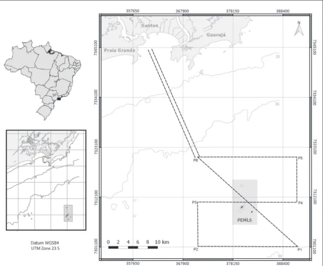
The study area lies within the quadrant defined by lati
-tudes -24.000° and -24.400° (7,345,095 mN and 7,301,068 mN) and longitudes -46.370° and -46.070° (360,646 mE and 391,504 mE) (Figure 1). It includes the PEMLS with
its emerged and submerged rock formations, the parks
surrounding waters, largely coincident with the Itaguaçu
sector of the Central Coast Marine Protected Area (created
by Decree Nº 53526, SÃO PAULO, 2008), and the area between the PEMLS and Santos and São Vicente bays. It covers areas with different characteristics, such near-shore
areas where it is possible to observe coastal seabirds and
farther offshore areas where pelagic seabirds can be found.
Three transects were established in the study area. Transect 1 (T1) is demarcated by the vessel’s track from
São Vicente Bay to point P6. Transect 2 (T2) follows the route defined by the points indicated in Table 1, fol
-lowing the order P6, P1, P2, P3, P4, P5 and P6. Finally, Transect 3 (T3) is the return path from P6 to São Vicente
Figure 1. Geographical location of the study area. Dashed lines represent the transects surveyed during the seabird census.
Table 1. Geographical and UTM coordinates (WGS84 datum, UTM Zone 23S) of the points that defined Transect 2 (T2)
in the study area.
Geographical Coordinates UTM Coordinates (Zone 23S)
Points Latitude Longitude Latitude m(N) Longitude (mE)
P1 -24.400° -46.070° 7,301,068 391,504
P2 -24.400° -46.270° 7,300,897 371,222
P3 -24.310° -46.270° 7,310,862 371,029
P4 -24.310° -46.070° 7,311,034 391,427
P5 -24.220° -46.070° 7,320,999 391,350
P6 -24.220° -46.270° 7,320,829 371,040
A total of 12 surveys were completed out between June
2013 and June 2015, approximately every two months and
covering all seasons.
Observations were made from survey vessels. The sampling units of this study were the “counting stations”
that divided each transect into 10-minute navigation/
observation intervals. The surveys consisted of counting
and identifying all birds, whether flying or resting (an ad
-aptation of the method suggested by Tasker et al. (1984)) during these intervals, observed within a 600-m wide tran
To correctly apply this method, it is necessary to re-spect certain navigation conditions such as constant speed, regular and known direction, favourable weather condi-tions without rain or fog (horizon must be visible) and
good sea conditions: 0 (calm) to 3 (gentle breeze) on the Beaufort scale. As an adaptation of the method, we used a 180° angle of view, thus covering both sides of the vessel (i.e., 300 m on both sides of the vessel). 13 to 15 m long
boats from local diving operators were used for the sur-veys and the observations were carried out during daylight from the upper decks, above the cockpit (vessels’ highest
point). Observers’ eyes were on average 3 m above sea level, with a horizon of approximately 6 km.
Data collected during surveys comprised biological (taxon and number of individuals), navigational (local time, period of observation, latitude, longitude, speed and direction of the boat) and weather information (cloudiness
and wind direction), and were recorded on field data sheets (BIOMASS, 1977). Binoculars (8 x 30 and 10 x 50), pho -tographic equipment (CANON EOS 7D camera with
70-300 mm lens) and a GPS (Garmin eTrex 20) were used in
all surveys. The identification of species was undertaken
in situ by qualified on-board observers and a posteriori
by photo analysis, both using identification guides (BINI, 2009; HARRISON, 1983; NOVELLI, 1997; VOOREN; FERNANDES, 1989).
After each survey, all navigation and biological infor-mation was added to a database. Navigation data included
the identification number of the survey, transect and sta -tion number, as well as the date, starting and ending times of the counting station (in minutes), vessel direction,
navi-gation speed (in knots and km/h), latitude and longitude
(in decimal degrees), cloud coverage, wind direction, and
any other relevant observation. Biological data comprised
the total number of seabirds per station and the number
of individuals of each species per station. Because of the difficulties regarding terns’ species identification at sea, all
terns were recorded as ‘Sternidae’.
Several parameters and derived rates were calculated, for example, the distance covered at each station (distance = navigation speed x time spent at each station). Total and mean speed values, distance covered, number of seabirds and taxa per transect and per km were calculated for each survey. All parameters were plotted on charts in order to analyse the seasonal variations of seabirds’ numbers and taxa.
To analyse seabirds’ spatial distributions, the geospa-tial information was plotted on thematic maps using the
open source geographic information system (GIS) software
QGIS (QGIS, 2013). In order to make comparisons among
surveys and due to the spatial data’s heterogeneity we
cre-ated a 5 km x 5 km grid. Biological data of the 12 surveys were plotted in the GIS, and stations (based on the loca
-tion of their starting points) located in a specific cell were
grouped, allowing comparison among the main taxa of resi-dent and migratory seabirds observed during surveys.
RESULTS
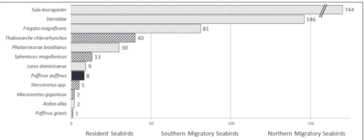
During the continuous censuses performed
through-out 12 surveys, 1,086 seabirds were recorded. The brown
booby (Sula leucogaster) was the most abundant species,
with 744 individuals counted. Terns (Sternidae family) were the second most abundant group, with 146 individuals
including South American (Sterna hirundinacea), Cabot’s (Thalasseus acuflavidus) and Royal (T. maximus) terns,
followed by the Magnificent frigatebird (Fregata magnifi -cens), with 81 individuals observed (Figure 2). These three
taxa are resident species and represent almost 90% of all birds observed during the surveys. Brown boobies and terns
also establish breeding colonies at the Laje de SantosIsland.
Seasonality
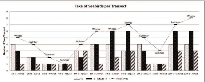
The numbers of individuals (Figure 3) and taxa (Figure 4) recorded on each transect on each survey were examined. By analysing the variation in species richness
during the surveys, a seasonality was observed, with an increase in the number of taxa seen during winter months
and a decrease in summer months. In contrast, the total
number of birds observed does not appear to follow any particular pattern.
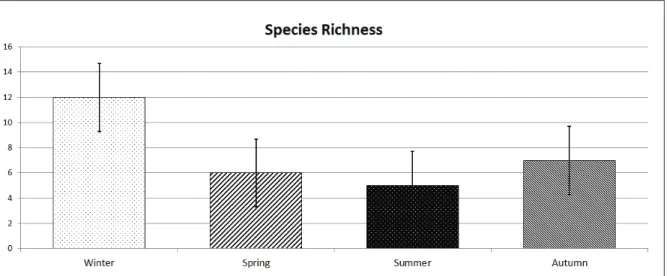
Considering these observations, we analysed the sea-sonality of individual species. Comparing the total number
of taxa per season (Figure 5), we found that richness in
winter was higher (considering standard deviation) than in warmer seasons (spring and summer).
To understand these differences we compared the seasonality of resident and migratory taxa (Figure 6).
Resident taxa were considered almost constant throughout the seasons. The Manx shearwater (Puffinus puffinus) was
the only migratory species from the Northern Hemisphere
and was observed in all seasons. Richness of migratory seabirds from the southern region of the ocean increased
during winter surveys (maximum number of taxa = 5),
decreased dramatically in spring surveys (number of taxa = 1), was nil in summer and increased again in autumn (number of taxa = 2). During winter surveys, migratory
birds from the south accounted for more than 40% of spe -cies richness, but in summer, they were totally absent from the survey area.
Figure 3. Number of seabirds observed per transect on each survey. The dashed line represents the total number of birds counted on each survey (sum of the three transects).
Figure 5. Total species richness by season. Error bars indicate one standard deviation.
Figure 6. Number of resident and migratory seabird taxa by season.
Spatial Distribution
The starting points of the 421 counting stations moni -tored over the 12 surveys and their distribution in the grid
cells are shown in Figure 7. Seabirds were seen at 211 of these stations, a sighting rate of 50%. This relatively low rate of observation might be related to the 10-minute navi
-gation/observation intervals.
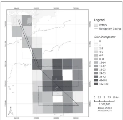
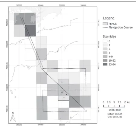
Spatial distribution maps of the three main
resi-dent taxa of the PEMLS (Brown booby, terns and Magnificent frigatebird) are shown in Figures 8, 9 and 10, respectively. Observations of the Manx shearwater (Figure 11) and the Atlantic yellow-nosed albatross
(Thalassarche chlororhynchos; Figure 12), were also
Figure 7. Starting points of the seabird observing stations monitored during
the 12 surveys, showing the grid with 5 km x 5 km cells used for analyses.
Figure 9. Number of terns (three species, see Methods) counted in each grid cell during the 12 surveys.
Figure 11. Number of Manx shearwater (Puffinus puffinus) counted in each grid cell during the 12 surveys.
chlororhyn-The Brown booby is widespread within the study area,
but it is sighted more frequently in the surrounding of the
Laje de Santos Island, particularly on its northern and eastern
sides, which are more sheltered from the regional
predomi-nant winds (field observation). Also, after breeding seasons, juvenile individuals were sighted flying around the island.
Terns also presented a wide distribution within the survey area, however, they were more abundant near the coast of the mainland. The frigatebirds were more numer-ous near the coastland and in areas where Sula leucogaster
were more frequently observed.
Manx shearwaters and Atlantic yellow-nosed alba-trosses were seen in the area between the Laje de Santos
Island and the 50 m isobath, the outermost studied area.
DISCUSSION
We identified seasonal variation on the species com -position during the study period: a higher number of taxa
was observed during winter; decreased in spring, reach the minimum during summer; and increased again in autumn.
These results suggest that seasonal variation is associated with the visit of migratory seabirds such as albatrosses and petrels from the south. This is consistent with the work
of earlier researchers in this study area (NEVES, 1997; CAMPOS et al., 2004; OLMOS et al., 2005) who ob -served that migratory birds from the extreme south, which reproduce during the austral summer, migrate north during winter where food resources are relatively more abundant. The brown booby, a resident species that nests on the
Laje de Santos Island and has stable colonies all over the
year, was well represented throughout the study area, with higher concentrations in the proximities of the island (the
colony’s nesting area). On several occasions, flocks of brown booby were seen flying between the nearby main
-land and the Laje de Santos Is-land and/or between near
rock formations and the nesting area. These observations suggest that these birds tend to feed around the nesting area, rather than farther from the colony.
Although it wasn’t possible to establish a statistical relationship with meteorological parameters, we observed
a tendency for Brown boobies to return to the sheltered side of Laje de Santos Island on days when the wind was more intense. The regions where the Brown booby is less
abundant correspond to the exposed side of the island and the anchorage area of the Port of Santos (according to the
Brazilian Navy’s nautical chart Nº 1711, DHN, 2016).
Terns were also observed all over the year, therefore the highest concentrations of terns were observed near the mainland coast, which can be related to the higher and continuous availability of food in this region, especially
due to the large volume of discards from small fishing boats. Further, terns were only seen on Transect 2 during their breeding season (CAMPOS et al., 2004). During this
period, individuals were observed leaving the nesting area
on the Laje de Santos Island to the open sea in search for
food. These birds were seen, on several occasions during the breeding season, together with Manx shearwater while
fishing.
Magnificent frigatebirds were seen in higher concen
-trations around the Brown boobies’ nesting area on Laje de Santos Island, and particularly near to the mainland
coast, in the Xixová-Japuí State Park surrounding, where
fishing boats are usually seen. This distribution pattern
is probably associated to the feeding behaviour of
frig-atebirds, which steal food from other birds (e.g. Brown
booby and terns) and take advantage of the discards from
fishing vessels.
The migratory seabirds most frequently sighted during this study were Manx shearwaters and Atlantic
yellow-nosed albatrosses. Both species were observed only in the region between the Laje de Santos Island and the 50 m iso -bath, indicating that these oceanic seabirds prefer deeper water areas, more distant from the coast. The presence of migratory seabirds from distant breeding colonies shows that the importance of the PEMLS extends far beyond its boundaries. Atlantic yellow-nosed albatrosses, which are
endemic to the Tristan da Cunha archipelago and Gough Island in the South Atlantic Ocean between Uruguay and
South Africa, appear to be regular visitors to the PEMLS
and its surroundings. Similarly, Black-browed albatrosses
(Thalassarche melanophris), native from the Malvinas/
Falklands and South Georgia in the subantarctic region, also visit regularly the PEMLS area (NEVES, 1997), al -though no individuals were sighted in the present study.
These and other species of albatrosses and petrels (or-der Procellariiformes) are protected birds and constitute the most threatened seabird group worldwide (CROXALL
et al., 2012). They thus receive and require governmental
and nongovernmental attention, and count on instruments for establishment of priority actions for their conservation.
Among these instruments, the Agreement for the Conservation of Albatrosses and Petrels (ACAP), of which
have been established by the National Action Plan for the Conservation of Albatrosses and Petrels (PLANACAP is
the Portuguese acronym; NEVES et al., 2006) which iden
-tifies the national strategies for conservation of these threat -ened species. Since the PEMLS area is frequently visited by these protected species, its importance transcends national borders and its maintenance concurs with the actions of both ACAP and PLANACAP.
Three important regions for seabirds were identified in the study area. The first was close to the mainland coast,
where we observed interaction between seabirds and the
commercial and artisanal fishing fleets. The second sur
-rounded Laje de Santos Island, which offers shelter and
food for the seabirds breeding on it. The third region, more exposed, was where migratory seabirds, adapted to rougher sea conditions, were more often seen during sur-veys for this study.
The use of a geographic information system allowed this study to make inferences and identify correlations re-garding the habits of monitored seabirds and the regions within the study area.
This regionalisation may be the most important result in terms of guidance regarding the future management of the
park. We recommend that the management actions of this
conservation unit consider, whenever possible, this spatial distribution and the seasonal occurrence of seabird species.
One of the purposes of studying the seabirds distri-bution within the Environmental Monitoring of the Laje de Santos Marine State Park Project (MAPEMLS is the Portuguese acronym), to which this study is a contribution, was to verify the methodological suitability of ship-based
surveys in coastal areas (water depths less than 50 m) es -tablishing standard methodology for this type of study in protected areas. The results show that the census method
used, together with GIS, is fully applicable and suitable for
the monitoring of seabirds in transitional areas between the coast and the open sea.
In light of the fact that some migratory species previ -ously seen in the area and studied by earlier researchers were not observed in the present study, we recommend an increased survey frequency, especially during winter months when the use of the PEMLS is at its highest by mi-gratory seabird species.
The spatial distribution analysis of species using the-matic maps represents an extremely useful tool to deter-mine regional patterns. Through the overlaying of distri-bution data with human water use (e.g. anchorage areas,
fishing areas, submarine gas pipelines, navigation routes,
submarine sewage outfalls, etc.) and modelling data, it is possible to determine the most vulnerable areas regarding real and potential anthropogenic impacts, and therefore, es-tablish contingency plans for each impact. Moreover, the association between spatial data and information about sea-sonal variation of migratory species, or even breeding peri-ods of resident species, would be helpful to direct sampling
efforts in further studies in order to obtain a more detailed
understanding of the population dynamics of the study area. Therefore, the creation of geo-referenced databases and a constant supply of new data, along with the populariza-tion of open source software, constitute together a means of great potential to aid sampling design, management and monitoring of coastal and ocean waters, and conse-quently for the conservation of the marine ecosystems and biodiversity.
ACKNOWLEDGEMENTS
This study was undertaken within the MAPEMLS project, coordinated by the Aquatic Studies and Research
Foundation – FUNDESPA and Petrobras, in collaboration
with the Albatross Project-Projeto Albatroz, sponsored by Petrobras via their Environmental Program. The au-thors wish gratefully to acknowledge the participation of the PEMLS administration, the captains and crews of the
Wreck-Hunter, Pé-de-pato, Cachalote and Anekim vessels for their logistic support and Sorraylla Rahim de Sá for her
efforts during the sampling as well as her collaboration in
the monitoring.
REFERENCES
ACAP. Agreement on the Conservation of Albatrosses and Petrels, 2004. J Int Wildl Law Policy, v. 7, n. 1-2, 2004.
BINI, E. Aves do Brasil: guia prático. Homem-pássaro
publica-ções, 2009. 200 p.
BIOMASS. Biological Investigation of Marine Antartic System and Stocks. Vol. 1: Research proposals. SCAR/SCOR,
Cam-brige, p. 79, 1977.
BRANCO, J. O. Aves marinhas e insulares brasileiras: bioecolo-gia e conservação. Itajaí: Editora da Univali, 2004.
CAMPOS, F. P.; PALUDO, D.; FARIA, P. J.; MARTUSCELLI, P.
Aves insulares marinhas, residentes e migratórias, do litoral do Estado de São Paulo. Aves marinhas insulares brasileiras: bioecologia e conservação. Itajaí: Editora da Univali, p. 57-82,
2004.
CROXALL, J. P.; BUTCHART, S. H.; LASCELLES, B. E. N.; STATTERSFIELD, A. J.; SULLIVAN, B. E. N.; SYMES, A.; TAYLOR, P. H. I. L. Seabird conservation status, threats and priority actions: a global assessment. Bird Conserv. Int., v. 22,
DE CAMPOS, F. R.; DE CAMPOS, F. P.; DE JESUS FARIA, P. Trinta-réis (Sternidae) do Parque Estadual Marinho da Laje de Santos, São Paulo, e notas sobre suas aves. Rev. Bras. Or-nitol., v. 15, n. 3, p. 386-394, 2007.
DHN – Diretoria de Hidrografia e Navegação. Port of Santos Nautical Charts (Carta Náutica do Porto de Santos). Rio de Janeiro: Marinha do Brasil, Divisão de Hidrografia e Navega-ção, 2016.
HARRISON, P. Seabirds: an identification guide. United King-dom: Croom Helm & A. W. Reed, Beckenham, 1983. HEINEMANN, D. A range finder for pelagic bird censusing. J.
Wildl. Manage, v. 45, n. 2, p. 489-493, 1981.
ICMBIO. Relatório anual de rotas e área de concentração de aves migratórias no Brasil. Cabedelo, PB:
CEMAVE/IC-MBio, 2014.
IUCN. The IUCN Red List of Threatened Species. Version
2016-3, 2016. Downloaded on 27 March 2017.
NEVES, T. Dossiê de gerenciamento do Parque Estadual Marin-ho da Laje de Santos, São Paulo. São Paulo: Instituto
Flo-restal, Secretaria do Meio Ambiente, v. 1, p. 2, 1997. NEVES, T. Plano de ação nacional para a conservação de
al-batrozes e petréis: (Planacap). Brasilia: Ministério de Meio
Ambiente (MMA), 2006.
NOVELLI, R. Aves marinhas costeiras do Brasil: identificação e biologia. Cinco Continentes Editora, 1997. 92 p.
OLMOS, F.; MARTUSCELLI, P.; SILVA, R.; NEVES, T. S. The sea-birds of São Paulo, southeastern Brazil. Bull. B. O. C. v. 115(2), 1995.
PALECZNY, M.; HAMMILL, E.; KARPOUZI, V.; PAULY, D. Population trend of the world’s monitored seabirds, 1950-2010. PLoS One, v. 10, n. 6, p. e0129342, 2015.
QGIS Development Team. QGIS Geographic Information Sys-tem. Open Source Geospatial Foundation Project, 2013. http://www.qgis.org/
SÃO PAULO (Estado). Decreto № 37.537, de 27 de setembro de 1993. Cria o Parque Estadual Marinho da Laje de Santos e dá providências correlatas. São Paulo: DOE-I, 1993. p.4. SÃO PAULO (Estado). Decreto № 53.526, de 20 de outubro de
2008. Cria a Área de Proteção Ambiental Marinha do Litoral Centro, e dá providências correlatas. São Paulo: DOE, vol. 118, 2008. p.5.
SICK, H. Ornitologia Brasileira, edição revista e ampliada por José Fernando Pacheco. Rio de Janeiro: Nova Fronteira, 1997.
SILVEIRA, L. F.; UEZU, A. Checklist of birds from São Paulo State, Brazil. Biota Neotrop., v. 11, p. 83-110, 2011.
TASKER, M. L.; JONES, P. H.; DIXON, T. I. M.; BLAKE, B. F.. Counting seabirds at sea from ships: a review of methods employed and a suggestion for a standardized approach. Auk., p. 567-577, 1984.