iMpaCTS oF THE STorM HERCULES iN porTUGaL
ângela SantoS1 SuSana MendeS2 João corte-real3abstract –the aim of this study is to analyse the impacts of the Hercules storm in Portu-gal. the storm occurred from January 5th to 7th, 2014. a brief characterization of the storm was conducted and the witnesses’ accounts were compiled, complemented with field survey before and after the storm. the results show that this event had origin in a strong system of low pressure that hit Portugal. the system triggered strong sea waves with long periods, run-ups between 6 to 9 m, and inundation depths mostly under 1 m. the effects on the Portuguese coastline showed some weaknesses in the spatial planning management: (i) the fact that a wave train res tricted to the beaches, front streets, ports and marinas caused significant damage; (ii) some people ignored the emergency management authorities, putting themselves in a risk situation.
Keywords: Hercules storm, media, witnesses’ accounts, field survey, risk awareness. resumo – iMpactodateMpeStade Hercules, eM portugal. neste estudo, analisam--se os impactos da tempestade Hércules, que atingiu Portugal entre os dias 5 e 7 de Janeiro de 2014. Caracteriza-se brevemente a tempestade, e apresentam-se os relatos das testemunhas e os resultados do trabalho de campo anterior e posterior à tempestade. este evento teve origem num forte sistema depressionário que provocou forte agitação marítima, ondas de longo período, run-ups de 6 a 9 m, com profundidades de inundação em geral inferiores a 1m. Os efeitos no litoral português ilustram algumas fraquezas no ordenamento e gestão do território: (i) o facto de um conjunto de ondas, mesmo restringidas às praias, marginais, portos e marinas, ter cau sado elevados prejuízos materiais; (ii) a circunstância de os avisos das autoridades da gestão da emer-gência terem sido ignorados por indivíduos, que assim se colocaram em situação de risco.
Palavras-chave: tempestade Hércules, comunicação social, testemunhos, trabalho de campo, sensibilização ao risco.
1 Centre for Geographical studies, institute of Geography and spatial Planning,Universidade de Lisboa, edifício da faculdade de Letras, alameda da Universidade, 1600-214, Lisboa, Portugal. email: angela.santos@campus.ul.pt
2 Geophysical institute, University of Bergen, allegaten 70, 5007 Bergen, norway and Bjerknes Centre for Climate research, Bergen, norway. email: susana.Mendes@gfi.uib.no
3 institute of Mediterranean agrarian and environmental sciences (iCaaM), University of Évora, Évora, Portugal. email: jmcr@uevora.pt and Department of aeronautics and transports, University Lusófona of Humanities and technologies, research Unit DreaMs, Lisbon, Portugal. email: joao.cortereal@ulusofona.pt
rement caractérisée, on a recueilli divers témoignages et on a observé le terrain, avant et après la tempête. Ce système dépressionnaire accentué a provoqué une forte agitation mari-time, avec des vagues de longue période et de 6 à 9 m d’amplitude. Les dégâts enregistrés révèlent certaines faiblesses de gestion de la part des autorités : i) il est anormal que des vagues n’ayant touché qu’une étroite bande littorale aient provoqué de tels dégâts matériels; ii) Les avis de danger émis par l’organisme chargé de gérer les situations périlleuses ont été ignorées par certaines personnes, qui ont ainsi couru des risques.
Mots-clés: tempête “Hercule”, média, témoignages, travail de terrain, enquête de terrain, sensibilisation aux risques.
i. intrODUCtiOn
Portugal has been experiencing atmospheric events that caused severe damag e and fatalities, such as the floods of 1876, 1967 and 1997 (Zêzere et al., 2014). However, scientific studies focusing on observational perspective are scarce (sousa et al., 2013) and even fewer studies deal with post-disaster field surveys. Pereira, et al. (2014) pointed out that newspapers are good data providers regar-ding temporal information about the natural disaster events that caused damage including direct injuries on the populations, as well as economic damage. thus, field surveys, carried out by the first author, are the best approach to obtain spatial inventories. in 2011 a storm destroyed the sand dunes at the south of Vagueira (fig. sM 1, supplementary Material, available online), damaged a road and reached the Aveiro Ria, which is about 200 m inland. the field survey showed the fast r econstruction of the sand dune, and a scouring of about 0.8 m on the road. also in 2011, a very rare episode of hail occurred in Lisbon (fragoso et al., 2011), where data was also collected in situ. another storm that occurred in 2013 gene rated waves that reached at least 5 m high in Cova, Figueira da Foz. the debris line was still visible at the base of Cova’s sand dune (fig. sM 2). at that time, there was also large debris deposited on the Cova’s south spur. although this storm did not cause any damage on the area, evidences were found that a section of the sand dune was collapsing.
Between January 5th and 7th, 2014 a low pressure system approached Portugal
from the atlantic Ocean. it was named “Hercules” by the Weather Channel ( h t t p : / / w w w. w e a t h e r. c o m / n e w s / w e a t h e r w i n t e r / w i n t e r s t o r m -names-2013-2014-20131001), which is a media company. However, the official name of this winter storm is “Christina” by the University of Berlin (http://www.met. fu-berlin.de/adopt-a-vortex/tief/). in this paper the “Hercules” name was selected because most of the information related to its impacts was provided by the media. its passage left significant damage due to strong winds, long period waves and intense precipitation. the most significant impacts occurred on the evening of Monday, Janua ry 6th and in the early morning of tuesday January 7th.
Long sea waves generated by atmospheric disturbances can be caused by atmos pheric gravity waves, storm activity, pressure jumps, frontal passages and squalls (rabinovich et al., 2009; Vilibic and sepic, 2009). these waves are similar to ordinary tsunami waves and can affect coasts in a similar way. they are usually called meteotsunamis or meteorological tsunamis. thus, the features of Hercules storm fits well in this type of natural hazards.
the emergency management authorities provided several storm warnings to the general population (Civil Protection, iPMa and the Maritime authority). the warnings were disseminated to the public by the media. in fact, the role of media has been increa sing in the dissemination of the information related to natural d isasters (Vasterman, et al. 2005; Barnes et al., 2008) not only live, but especially on online archives (tschoegl et al., 2006; santos et al., 2007; santos, 2011; santos and Queirós, 2013). the media also played an important role in the dissemination of the witnesses’ accounts by provi ding videos, photos and reports online. the witnesses’ accounts are very important becau se among other data allows a com-prehensive analysis of a natural disaster (Levine et al., 2004; tinti et al., 2005). for example, Vucetic et al. (2009) compiled the witnesse s’ accounts of the 1978 m eteotsunami, in order to put together that event.
although the Hercules storm caused damage in the interior of Portugal, the objective of this study was to investigate the impact of the storm on coastal areas of Portugal (fig.1), with the aim of pointing out the damages on natural systems, structures and infra-structures, as well as fatalities.
in the next section, the methodology is presented, followed by the storm charac-terization. in section iV, the witnesses’ accounts are collected, complemented by the results of the field survey. finally, the discussion and conclusions are presented.
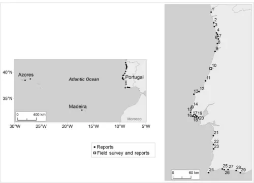
fig. 1 – Points with witnesses reports on the storm impact and the field survey. see text for details. Fig.1 – Locais com testemunhos dos impactes da tempestade e trabalho de campo. ii. MetHODOLOGy
the methodology applied to this study was based in the following methods: the storm characterization, the compilation and interpretation of the witnesses’ accounts and a post-tsunami field survey. the storm characterization was carried out by the collection of satellite images, forecasted weather maps and tide gauge data.
the witnesses’ accounts were compiled from the media, reporting damages all over the Portuguese coastline that occurred in the evening of January 6th. Most of the
reports were broadcasted live on the Portuguese tV channels, on Monday evening (January 6th) and on tuesday morning (January 7th), and later posted on online
archi-ves. the major sources of information used in this study were RTP Notícias online (www.rtp.pt), Sic Notícas online (www.sicnoticias.sapo.pt), Porto Canal online (www.portocanal.sapo.pt) and TVI24 online (www.tvi24.iol.pt). in addition, daily newspapers also provided important data on their websites: Correio da Manhã o nline. (www.cmjornal.xl.pt), Diário de Coimbra online (www.diariocoimbra.pt) and Região Sul online (www.regiao-sul.pt). the Rádio Renascença radio station also posted online information about the storm’s impact at Rádio Renascença online (www.rr.sapo.pt). furthermore, many videos and photos were posted online by the witnesses themselves, which also provided important valuable data.
as a complement to the witnesses’ accounts, a field survey was conducted on some coastal areas. the selection of the studied points were based on existing pre-vious research and field surveys, as well as on availability of post-storm photos. the Hercules storm generated waves of unusual long periods (section iii), fitting in the definition of a meteotsunami, causing its behaviour on the coastline as “tsunami like”. therefore, post-tsunami field survey techniques (Borrero, 2005; imamura et al., 2005; Dominey-Howes et al., 2012) were applied by the first author with the aim of: i) documenting damages on camera, ii) measuring longitude, latitude and height using GPs iii) pointing out features of the storm, and iv) measuring maximum water level height and inundation depths on the affected coastal areas.
iii. stOrM CHaraCteriZatiOn
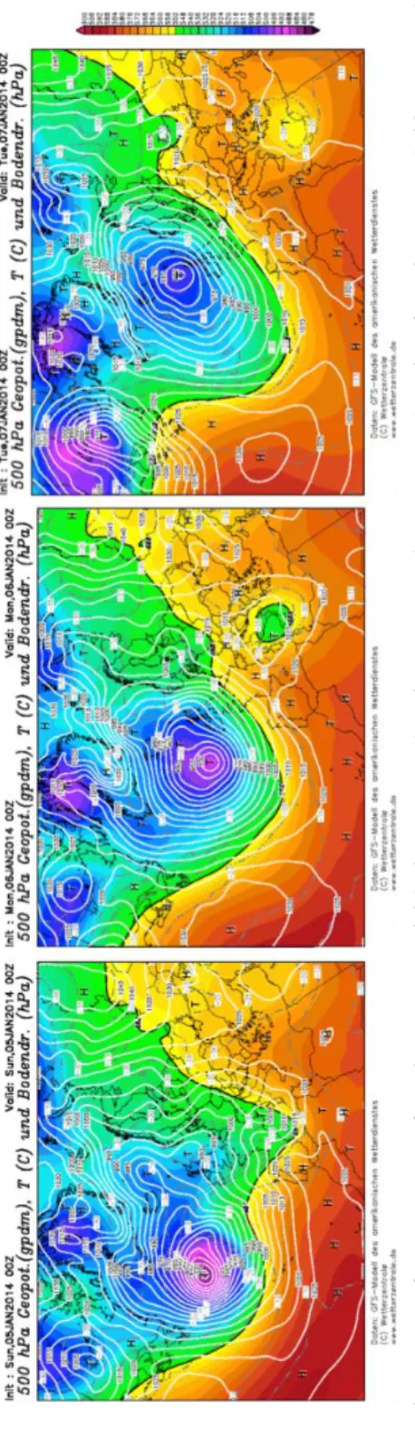
On January 5th, 2014 the north atlantic was under the influence of a deep
depres sion, in the lower troposphere, with a closed nucleus above 40ºn, between the longitudes of 0 to 40ºW, to which was associated an occluded frontal system with a cold front to the West of the iberian Peninsula extending north, to the UK. at the centre of the depression, located at 50ºn, 30ºW, the pressure at the surface (12:00 UtC) was lower than 940 hPa. the system extended to the south till 30ºn as a cold long wave in the mean sea level pressure field; the associated winds were strong, especially north of 35ºn. the deep vertical structure of the system was asso ciated with wind values that increased with altitude Portugal was under the influence of a shortwave high pressure ridge with advection of warm air. a cold low was located at the Gulf of Genoa in the Mediterranean sea.
then, from January 5th to 6th, all the depressionary structure moved to n-ne.
the cold frontal surface was (12:00 UtC) on the north and centre of Portugal. the entire country was under the influence of warm air from sW and positive advection of relative vorticity. also, from January 5 th to 6 th, an intensification of the wind was
observed, both at surface and aloft; at the 500 hPa level the wind intensity was higher than 50kt.
On January 7th, the cold frontal surface mentioned above, was already
influen-cing the south of Portugal, by moving from nW to se. in the middle troposphere, at 500 hPa, over Portugal, an intense positive advection of relative vorticity was associa-ted to wind intensities of 60 to 70 kt. the high pressure ridge that on Janua ry 5th was
located over Portugal two days later was influencing the Gulf of Genoa. the above mentioned cold low was observed to move to the north of africa. furthermore, from January 5th to 7th, over the atlantic Ocean, the fetch length was large with strong
winds from sW. the propagation of this low-pressure system was very well identified by the Global forecast system (Gfs) analysis displayed in figures 2 and 3.
fig. 2 – G
fs
forecasts maps of 500 hPa geopotential (colour contours) and temperature (grey contours), and surface air pressure (white contours),
January 5th to 7th at 00U tC ( www .wetterzentrale.de ). Fig. 2 – Mapas de pr
evisão do GFS dos campos do geopotencial (a cor
es) e da temperatura (cinzento) aos 500hPa, e da pr
essão atmosférica à
superfície (branco), 5-7 de Janeir
o às 00UTC.
fig. 3 – G
fs
forecasts maps of 850 hPa geopotential (white contours) and temperature (colour and black contours), January 5
th to 7 th at 00U tC (www .wetterzentrale.de). Fig. 3 – Mapas de pr
evisão do GFS dos campos do geopotencial (a branco) e da temperatura (a cor
es e pr
eto) aos 850hPa, 5-7 de Janeir
finally, on January 8th all the cyclonic structure was in the lower tropos phere,
over the atlantic Ocean fragmented. a high pressure ridge of long wavelength b etween 20ºW and 40ºW was observed. above Portugal, at the surface, the wind was weak from south, and a new frontal surface was now influencing the country from the nW. at 500 hPa, the long wavelength trough was still obser ved with warm air advection and positive advection of relative vorticity at 850 hPa and 500 hPa. a lthough the Hercules storm had completely vanished on Janua ry 8th, Por tugal still
remained under the influence of rainy weather conditions, although not stormy. the most significant impacts occurred on the evening of January 6th and in the
early morning of January 7th during the high tides. figure 4 shows the avai lable tide
gauge stations that recorded the Hercules storm (www.ioc-seale velmonitoring.org) in mainland Portugal. Due to the evident unreliability displayed by the data regis-tered at Lagos station, the authors decided to rely on the Cascais data set. the C ascais tide gauge station clearly shows that the maximum water level corresponded to the high tide of the January 6th, about 18:40 (UtC), and in the early morning of
January 7th. Data also show clearly long period waveforms of about 10 minutes, a
feature also observed in meteotsunami events.
fig. 4 – tide gauge recordings during the Hercules storm: a) Cascais; b) Lagos; c) and d) zoom of Cascais data: second high tide on of January 6th (c) and first high tide on January 7th (d).
Fig. 4 – Registo dos marégrafos referentes à tempestade Hércules: a) Cascais; b) Lagos; Ampliação do gráfico de Cascais: segunda maré alta de 6 de Janeiro (c)
table
i –
summary of the impacts.
Quadr
o I – Resumo dos impactos.
Points storm parameters Damage fatalities n atural features
structures and property
1-Vila Praia de
Âncora
---- Coastal areas of the
Caminha
municipality flooded - sand and trash dragged away (Carmo and Paiva, 2014)
- W
arehouse
damaged
(Carmo and Paiva, 2014)
---
2-Esposende
---- 15 m of sand dunes were destroyed
(Carmo and Paiva, 2014) - W alls collapsed
(Carmo and Paiva, 2014)
---3 -
Póvoa de V
arzim
- s
and deposited on roads
(f
ernandes and
r
ibeiro, 2014)
- at least 3 shopping malls damaged - bar severely damaged and with sand inside (
fernandes and
r
ibeiro, 2014)
- woman caught by a wave (rescued) (
fernandes and
r
ibeiro, 2014)
4 -
Matosinhos
- 0.5 m of inundation depth at the residential areas - 4 waves, the 2nd and the 4th being the lar
gest (PC, 2014a; PC, 2014b; PC, 2014c) - residential areas of Pescador es beach flooded in Angeiras, Lavra, and Antune s a v.
(Leça da Palmeira) - streets full of debris and sand (PC, 2014c)
- “
severe damage” on the beach
structures (bars and surf schools) - Damage on the beach structures of Angeiras Norte
, Paraíso and Leça da Palmeira beaches (t V i24, 2014c) ---5- Oporto - t
wo major waves, one of
them inundated the coastal area, within 10 to 15 sec (PC, 2014a)
---- 20 cars (including a tourist bus) dragged inland on the
Foz do Dour
o,
- On the
Ourigo
beach the
restaurant “Chis” was completely destroyed with rubble scattered all over the beach (PC, 2014a) - 4 people injured, and many more caught by the wave on the
Foz do Dour
o. 1 man
6-
Gaia
---- a
bout 6 km of sidewalk damaged
(f erreira and silva, 2014) ---7- Espinho
---- 2 beach bars flooded (rtP
n , 2014a) ---8- Ovar - W
aves higher than 9 m high
at Furadour o, Ovar . ( r ibeiro et al., 2014) -
sand, mud and concrete stones
dragged inland at
Furadour
o, Ovar
(Bessa and
Valentim, 2014)
- Levees destroyed (Bessa and
Valentim, 2014)
- One man injured while walking near the shoreline (rtP
n
, 2014e).
9-
Ilhavo
- W
aves higher than 8 m high
(r
ibeiro
et al.,
2014)
- s
and dunes destroyed on the
Barra beach ( r ibeiro et al., 2014) - r
estaurant destroyed on the
Barra beach ( r ibeiro et al., 2014) --- 10-Figueira da Fo z - W
aves 7 m high and winds
of about 100 km/h (Carmo and Paiva, 2014) - Uncovered about 100 m of an old rocky structure that supported the artificial sand dune of the
Cabedelo
beach (Carmo and Paiva, 2014) - at the south of
Cova
, overtopped
the sand dunes and reached the pine trees. (Cruz, 2014) - Parking lot overtopped at Cabedelo,
damaging walls, fishing
port and all the sidewalks. - Destroyed the sidewalks of
Costa de Lavos . (J n , 2014) - Market gardens of Leir osa flooded
and several sidewalks destroyed
(Carmo and Paiva, 2014)
- n
o fatalities reported,
but the populations of Buar
cos and São Pedr o were in danger (DC, 2014) 11 -São Pedr o de Moel ---- Afonso Lopes V ieira Squar e
flooded (Carmo and Paiva, 2014)
- Houses and restaurants flooded and damaged. - Public infrastructures destroyed (Carmo and Paiva, 2014)
---12-
Caldas da Rainha
-One major wave flooded the Mar A
venue . 19:00 (t V i24, 2014i)
---- Dragged away 4 cars (
tV i24, 2014i) ---13 -Peniche
---- Parking lot flooded, near
the marina - 8 vessels and several structures at the marina damaged (tV
i24, 2014g)
-
a
male kitesurfer was
rescued at the
Baleal
beach by the fire-fighters and the Coastal Guard (tV
14
-Ericeira
W
aves were 8 m high,
period of 20 sec (Carmo and Paiva, 2014)
---- r
estaurant and 2 bars destroyed
at the
Algodio
beach (
n
orth)
- Destroyed about 10 vessels at the fishing port - Cof
fee shop and naval club
flooded. - sidewalk and walls damaged at Praia do
sul and
Foz do Lizandr
o
(Carmo and Paiva, 2014)
- t
wo men were caught by
the waves, but only 1 was injured.
the water level
reached their necks (Carmo and Paiva, 2014)
15-Sintra
- W
aves 8 to 9 m high,
reaching 15m, around 18:00 (ramalhinho, 2014)
- f
looded the beaches of
Praia
Grande
and
Praia das Maçãs
- Parking lot of Adraga beach flooded ( tV i24, 2014b)
- Damage on some roads. - at Praia Grande
beach the stone
benches were ripped away and the walls were damaged; deposits of sand and debris on the roads - the bridges that provide access to Magoito
beach were destroyed
- Damages at Azenhas do Mar beach. ( tV i24, 2014b) --- 16-Cascais
---- Damage on a restaurant and on 2 bars (
rt Pn , 2014d) ---17- Tamariz beach, Estoril - W
aves were 5 m high,
reaching 9 m -(sousa, 2014)
---- s
tone sidewalk ripped away
- Bars and restaurants damaged - several promenades washed away
, debris scattered all over the
beach and sidewalk (
sousa, 2014) --- 18-Car cavelos ---- s
ignificant damage on the
restaurants and bars at
Car cavelos beach ( tV i24, 2014a) --- 19-Paço de Ar cos
2 vessels sank and at least 12 were damaged (
si
C
n
, 2014a)
---
20-Costa da Caparica
- a
t the high tide of
07/01/2014, between 6:00 and 7:00, the waves were 6 – 7 m high (
tV i24, 2014e). - São João and Fonte da T elha
sand dunes washed away (tV
i24, 2014e)
- t
he sea overtopped the levees
at the urban area of Costa da Caparica, causing significant damage on the restaurants close to the shore (
si C n ;2014c; tV i24, 2014d).
- Damage on 3 or 4 vessels at Cova do
Vapor and debris
was deposited on the road. (tV
i24, 2014e) --- 21-Santiago do Cacém ---- Damages on the Melides and Santo André beaches (t V i24, 2014f) ---22-
Porto Covo, Sines
---- a
vessel destroyed at the
Porto Covo pier ( tV i24, 2014f) ---
23-Vila Nova de Milfontes,
Odemira ---- r estaurant at the Far ol beach
damaged - 2 vessels damaged and fishing materials were washed away at the fishing port (
tV i24, 2014f) --- 24-Sagr es ---- Damages on cof
fee shops, bars,
and other annexes, at
Beliche, Tonel and Martinha l beaches, and on the Baleeira port ( rs , 2014a) ---25 -Portimão ---- r
estaurants and bars
were damaged - a pier of the marina was damaged at the
Rocha beach (r tP n , 2014b) --- 26 -Lagoa ---- t he low areas of Carvoeir o, Lagoa were flooded ( rt Pn , 2014b).
- Damages on restaurants, a bar and the
scouts headquarters (si C n , 2014b). - Damages in Ferragudo
restaurants, public areas and beach annexes (
rs
, 2014b).
27-Armação de Pêra
---- f
ishermen facilities were
destroyed ( rt Pn , 2014b) --- 28-Quarteira --- Quarteira A v. flooded (rs , 2014a)
---- 12 young tourists went swimming, unaware of the danger and had to be rescued by the maritime authorities (rtP
n , 2014f; si C n , 2014b) 29 - Praia de Far o, Far o ---- s
and dunes overtopped by
waves that reached
Ria Formosa (rs , 2014a). ---Azor es ---- s
ignificant damages on the
ports of V ila Nova and Biscoitos , Ter ceira Island . t he waves
overtopped the breakwaters and concrete blocks were dragged inland
fisherman could not go
out to sea for a week (neves
et al.,
2014)
- Maritime transportation was suspended between
Ter
ceira
and
other islands. - Damages on the beach structures of Piedade (Ribeirinha)
and
Praínha do Norte, Pico
island
(Carmo and Paiva, 2014)
---Madeira
- W
aves were 6 – 9 m high at
Porto Moniz (f ernandes et al., 2014). - W
aves inundated streets and
promenades at
Porto Moniz
.
- W
aves overtopped the levees at
Paul do Mar (f ernandes et al., 2014) ---- s
everal tourists were caught
by the waves, and one woman was injured at Porto Moniz (fernandes
et al.,
iV. Witnesses’ aCCOUnts
the location of the points described by the witnesses is presented in figure 1, and table i summarizes the reports. the places are ordered from north to south. the witnesses reported several storm parameters, damages that were separated between damages on natural landscapes, structures and properties, and fatalities.
in Matosinhos (Point 4), four waves were observed, the second and the fourth being the largest ones (PC, 2014c). However, one major wave was responsible for the flooding on the coastal areas of Porto (Point 5), Caldas da Rainha (Point 12) and Tamariz beach, Estoril (Point 17). the witnesses also reported the wave heights, estimated based on their knowledge about the local areas. the wave heights ranged between 5 m in Tamariz beach, Estoril (Point 17) and 9 m height at Furadouro, Ovar (Point 8).
significant damage was observed along most of the Portuguese shoreline, including azores, as presented in table i. exceptions occurred in Cortegaça, Ovar (Point 8) where there were no damage or injuries, but the Cortegaça camping site was in danger of being flooded (Bessa and Valentim, 2014). in Madeira, although the waves overtopped the levees, no damage was reported (fernandes et al., 2014). although sand dunes are natural barriers these structures did not stand the sea onslau ght in several coastal areas such as in Esposende (Point 2), in Ilhavo (Point 9), in Figueira da Foz (Point 10), Costa da Caparica (Point 20), and Praia de Faro, Faro (Point 29).
in some places streets were closed down: at Matosinhos (Point 4) the sea front streets were full of sand and debris, and the traffic was cut between the Liber-dade Avenue (av) and Antunes Guimarães Avenue in Leça da Palmeira (near the new Port authorities of Douro and Leixões) and the Almeiriga Norte St., between the Paraíso and Memória beaches, in Perafita (tVi24, 2014c). at Porto (Point 5), the autho rities had to progressively increase the safety perimeter (rtPn, 2014d) because people would not stay away from the coastline; in Caldas da Rainha (Point 12) one major wave flooded the Mar Avenue, at the Foz do Arelho beach, dragging away four cars although no injuries were reported. this happened soon after 19:00 hours. follo wing this, the beach bars and streets were closed to traffic (tVi24, 2014i).
there were no fatalities in Portugal, however around 20 people needed to be rescued in Póvoa do Varzim (Point 3), Porto (Point 5), Furadouro, Ovar (Point 8), Peniche (Point 13), Ericeira (Point 14) and Quarteira (Point 28). in Madeira, seve ral tourists were caught by the waves (fernandes et al., 2014) while at Paul do Mar, the local population took safety measures.
although no further incidents were reported, many witnesses adopted a risky behaviour: in São Pedro de Moel (Point 11), several photos and videos taken by witnesses and reporters (e.g., tVi24, 2014c, 2014) showed local people running at the last minute from the waves. at Cascais (Point 16) videos and photos also showed locals adopting risky behaviour patterns by taking photos too close to the
the very last minute. Being caught by the wave, he was able to escape and was later evacuated by car.
Disaster prevention measures were taken by stakeholders: in Matosinhos (Point 4), three families were evacuated; in Gaia (Point 6) an elementary school with 52 children was evacuated (ferreira and silva, 2014); in Espinho (Point 7) the Regimento de Engenharia de Espinho had been building sand bars for the past several weeks (rtPn, 2014a). as a consequence, only two beach bars were floode d and no further consequences occurred; in Peniche (Point 13) the sea flooded the parking lot near the marina. there was no further damage in the area because it had been closed to traffic several days before the storm (tVi24, 2014g). in Sintra (Point 15) the roads were closed to traffic because the waves were reaching them (ramalhinho, 2014).
V. fieLD sUrVey
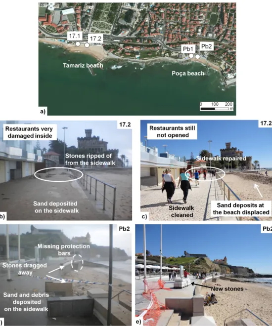
the field survey was conducted on several places displayed in table i and in figure 1: Figueira da Foz (Point 10), Ericeira (Point 14), Tamariz (Point 17), Carca-velos (Point 18). at the Poça beach, Estoril no witnesses’ accounts were available, showing that field surveys are indeed fundamental work. the field survey results are presented in table sM i.
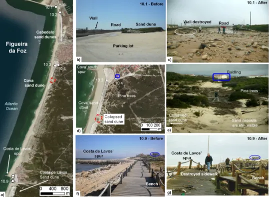
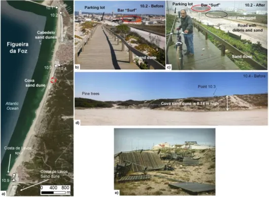
a field survey had been conducted at Cabedelo, Figueira da Foz (Point 10.1) before this storm on april 18th, 2012 (fig. 5b and sM 3b). Photos after the storm
show that the waves overtopped the parking lot which is 5.67 m high (table sM i), inunda ting it and depositing sand and small boulders. it partially destroyed a wall near the road. the sand dune is 9.13 m high (point 10.2), and did not suffer signifi-cant damage.
the Cova’ sand dune showed to be a natural barrier (fig. sM 3d, Point 10.3), reaching a height of 13.84 m. in 2013 part of the sand dune was showing signs of collap sing (fig. sM 2) being almost as the same level as Point 10.4 (5.10m). although there were no structural damages on the area, the collapsed sand dune allowed the water to penetrate inland till the pine trees (fig. 5d, e).
the field survey conducted on Costa de Lavos on June 13th, 2013 shows that the
sea front of Costa de Lavos (fig. 5f, Point 10.9) is located on high ground at 10.91 m, as is the south spur (Point 10.6, is 9.13 m). the storm did not damage any building or important infrastructure, but it completely destroyed the wooden sidewalk (figs. 5g and sM 3e) which is between 7.34 m and 8.77 m high (Points 10.7-9).
fig 5 – field survey conducted at Figueira da Foz: a) framework; b) and c) Point 10.1 before and after the storm; d) Zoom of Cova sand dune; e) Cova sand dune photo;
f) and g) Point 10.9 before and after the storm. c, d, g: Photos taken by Pedro a. Cruz. Fig 5 – Trabalho de campo na Figueira da Foz: a)Enquadramento; b) e c)Ponto 10.1 antes e depois da tempestade; d) Duna da Cova- ampliação de a; e)Fotografia da duna da Cova; f e g) Ponto 10.9 antes e depois da tempestade; c,d,g: Fotografias tiradas por Pedro A. Cruz.
Ericeira (Point 14) was surveyed on several occasions, both before and after the storm. at the Norte beach, the sea waves moved several large boulders, caused a landslide and significant destruction on a concrete stair at Point 14.2, located at a height of 8.12 m (fig. sM 4 b, c, d). the waves also ripped away the concrete bricks of the sidewalk (fig. sM 4i), and completely destroyed all the beach bars (figs. 6b, c and sM 4e, f) except one that remained standing. the “algodio” bar is located about 7 m above mean sea level (Point 14.4). the first author measured an inundation depth of 2.7 m on the bar (fig. 6 c), giving a local run-up of 9.7 m. furthermore, the waves ripped away about 75 m of the concrete sea wall (fig. sM 4 g), which was deposited on the road. the cleaning operations started on January 7th and about 2 months later, on March 8th the road was clear of the debris (fig. sM
4 h). the beach was about 5 m high before the storm. However, figure sM 4j shows the erosion of the beach close to 2 m, and the access to the beach (Point 14.5) could not be used.
the naval club, located at a height of 5.19 m (Point 14.6), was completely des troyed (fig. sM 5 b, c), and on March 4th 2014 it was completely renovated (fig. sM 5 d).
two men trapped inside the club said the water level reached their necks (table i). the break water is 6.57 m high (Point 14.8), and the witnesses also reported that the waves passed over it. the difference in heights is 1.38 m which confirms the witnesses’ accounts. On the other hand, photos taken during the storm (fig. sM 5e) and in the evening of Januar y 7th (fig. sM 5 f) show the waves hitting the breakwater
and passing over it, valida ting the reports (table i). in addition, photos taken before and after the storm at the fishing port (fig. 6 d, e) showed a significant deposition of sand (fig. sM 5 g) that most likely ori ginated from the Norte beach. the maximum inundation level was 4.51 m (Point 14.11) whereas the ground has a height of 3.9 m (Point 14.12), which shows that the breakwater had an important role in decreasing the waves’ impact on the fishing port because the inundation depth was 0.61 m only. since the fishermen’s warehouses are located on elevated ground (fig. sM 5 h) the waves did not cause significant dama ge inside the facilities, but the wave currents were strong enough to destroy several v essels, and ripping away a bench and the civil protection sign (fig. 6 e).
fig. 6 – field survey at Ericeira: a) framework; b) algodio bar destroyed; c) Bar and road cleaned from debris; d) and e) Point 14.13 before and after the storm; f) Damage at Sul beach. Fig. 6 – Trabalho de campo na Ericeira: a) Enquadramento; b) Bar Algodio destruído;
c) Bar e estrada limpos de detritos; d) Ponto 14.13 antes da tempestade; e) Ponto 14.13 depois da tempestade; f) Estragos na Praia do Sul.
the Sul beach also suffered significant damage from the waves that ripped awaythe concrete floor and seawall, scattering debris and stones and leaving a hole on the ground (fig. sM 6 f and 6 b, f, g). although by March 7th the sand and debris
had been cleared from the sidewalk (fig. sM 6 c), damage was still visible. the waves hit the sidewalk, breaking and increasing significantly in height (fig. sM 6 d). Photos taken after the storm showed sand deposited on the sidewalk and broken windows in a restaurant (fig. sM 6 d, e). the sidewalk is located at about 6 m high (Point 14.14, Point 14.15, and Point 14.16); the windows are located about 2 m above the ground, giving a run-up of more than 6 m. the swimming pools of the hotel, at the same level as the sidewalk, were also very damaged (fig. sM 6 h). in addition, a fishing vessel was reco vered from the sea. it was found around 8 m deep, about 2 km south of Ericeira and about 500 m from the beach, as reported by profes-sional divers of nDivers.
the January 7th survey showed a similar situation at Tamariz beach, Estoril
(Point17), with sand deposited on the sidewalk and stones ripped away from it (fig. 7 b and sM 7 b). the witnesses and owners of the promenade’s restaurants and bars also reported damage (table i). On March 8th, 2014 everything was cleaned
and repaired (fig. 7 c and sM 7 c), and one restaurant was already opened for busi-ness. Point 17.1 and 17.2 were 5.59 m and 5.00 m high, indicating the waves were at least 5.6 m high.
the media did not report any damage on the Poça beach, Estoril. nevertheless, the first author found significant damage (fig. sM 7 d and 7 e). the inundation mark was at 6.12 m (Point Pb1). the sidewalk is 5.40 m high therefore the local inunda-tion depth was 0.72 m, enough to scatter the sea walls stones on the sidewalk. On March 8th, 2014 the protection bars were still missing (fig. sM 7 f), but new stones
were already available on site to rebuild the area.
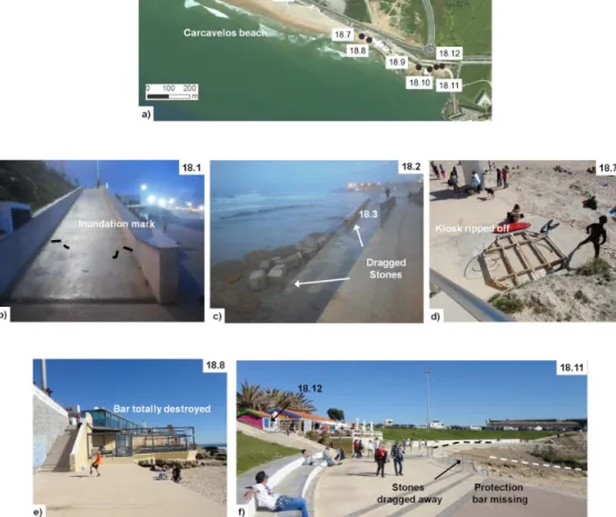
at Carcavelos (Point18), the inundation marks (fig. 8 b) left on the sidewalk showed that the waves reached a maximum of 5.56 m (Point 18.1). the stones were displaced (fig. 8 c,) at a height of 3.85 m (Point 18.3). the bars, restaurants and surf school (Point 18.4), located at a height of 5.35 m, suffered significant damage (fig. sM 8d); in the same area there was sand erosion on the stairs and sand depo sited on the ramp (fig. sM 8 b and c). On March 8th 2014, all shops were opened for
busi-ness (fig. sM 8 e). the bar “surf” (Point 18.5) which is located at 6.43 m did not suffer any damage (fig. sM 8 f), and in the evening of January 7th it was opened for
business. the sand reached 6.01 m (Point 18.5), showing the waves did not inundate the sidewalk. the most significant damage was observed at the eastern part of Car-cavelos beach (fig. sM 8 d, e, f, g, h, i): a kiosk was torn apart (Point 18.7), being located at 4.19 m height, as well as the bar “fizz”, located at 4.25 m (Point 18.8). the protection bars were ripped away on several places (Points 18.9, 18.10 and 18.11) showing the waves were higher than 5.40 m. the bar “Moinho” suffered significant damage, despite being located at a height of 6.85 m (Point 18.12). On March 8th it
fig. 7 – field survey at Estoril: a) framework; b) sand deposited on the sidewalk and stones ripped away on Point 17.2; c) Point 17.2 cleaned; d) Damage at the Poça beach; e) new flagstones available.
Fig. 7 – Trabalho de campo no Estoril: a) Enquadramento; b) Areia depositada no passeio e pedras arrancadas no Ponto 17.2; c)Ponto 17.2 limpo; d) Os estragos na Praia da Poça;
fig. 8 – field survey at Carcavelos beach: a) framework; b) inundation mark; c) stones from the ramp were dragged away; d) Kiosk ripped away; e) restaurant completely destroyed;
f) Point 18.12 shows the maximum inundation area.
Fig. 8 – Trabalho de campo na praia de Carcavelos: a) Enquadramento; b) Marca da inundação; c) Pedras da rampa arrastadas; d) Quiosque totalmente destruído; e) Restaurante totalmente
the storm was very well documented by the witnesses who posted news, articles, videos and photos on online archives. Most witnesses described one or two waves, around 6 - 9 m high (table i). in most coastal areas, the waves completely flooded the sand beaches, and overtopped the levees and breakwaters on the evening of January 6th
and early morning of January 7th. these reports were validated by the Cascais tide
gauge station. the flooded areas were not significantly large being restricted to the beaches, sea fronts, marinas and ports, and on some streets of the low coastal areas, inclu ding both commercial and residential buildings. a preliminary report revealed that the Hercules storm caused more than 16 million euros in damages (Pinto et al., 2014). the witnesses’ accounts also showed that the authorities were able to correctly forecast the storm and to warn the coastal populations in time. the immediate response of local authorities was commendable, not only in the emergency response but also in assessing damages and cleaning operations. However, the Portuguese population did not gain significant experience from previous disasters, and the “culture of risk” had not being completely assimilated. Hence, some locals and tourists did not take the warnings seriou sly, moved into dangerous areas too close to the shoreline to film or take photos of the event. as a consequence, several people were caught by the waves. some were able to escape by themselves, but others needed assistance (about 20 people).
Previous involvement in hazard incidents is important in the risk perception (Queirós et al., 2007; Momani and salmi, 2012), and after this event the Portuguese population was more aware of coastal dangers. nevertheless, a new incident happe-ned on March 3rd, 2014 (sol, 2014) in which a 60 year old woman was caught by a
wave at Poça beach (fig. 10) and died (rodrigues et al., 2014). in order to prevent similar situations in the future it is necessary to develop strategies of spatial planning that involve the implementation of safety awareness, dissemination of disaster pre-vention measures and mitigation strategies to the general public. these strategies involve organization of drills and evacuation exercises (Queirós and santos, 2013), as well as the distribution of informative pamphlets (santos et al., 2013). at Ribei-rinha, Pico island, azores, the beach structures will not be reconstructed on the same place because it is clearly unsafe (Carmo and Paiva, 2014). Most likely those struc-tures will be rebuilt on higher ground.
still, the Hercules storm showed the weaknesses of the coastal areas to a mari-time extreme event, showing that coastal protections need serious evaluation and urgent mitigation actions are necessary. the problem of coastal erosion in Portugal has been addressed in the past (Paixão 2013, trindade and ramos-Pereira, 2013), but no practical solutions have been found yet. although sand dunes offer a natural protection, they are not reinforced material. the construction of spurs and breakwa-ters offer some protection but other engineering solutions should be considered, e.g. all breakwaters and sea walls should be reinforced and elevated at least by 0.5 m.
the Hercules storm was characterized by long period waves, causing its beha-viour on the coastline as “tsunami like”. this phenomenon is designated by scientific
literature as meteotsunami or meteorological tsunami. therefore, post-tsunami field survey techniques were used in order to study the impacts of this storm. the field sur-vey confirmed the witnesses’ accounts of wave heights of 6 to 9 m and confirmed the deposition of sand reported by the witnesses. it showed scouring and erosion nearby those areas. the inundation depths were less than 1.0 m in most areas, being restricted to the sea fronts, marinas and ports. Photos taken before and after the storm allowed a better comprehension of the coastal impact of the storm. the field survey also showed that the Portuguese coastline has high ground nearby the beaches and ports allowing the users to escape safely and in time to higher ground.
aPPenDiX a. sUPPLeMentary MateriaL
supplementary material related to this article can be found at http://revistas.rcaap. pt/finisterra/article/view/6468
aCKnOWLeDGMents
this study was supported by the tsuriMa Project - tsUnami risk Management for spatial plan-ning and civil protection (PtDC/CsGeO/118992/2010) funded by the foundation of science and tech-nology (fCt), Portugal. the authors are very thankful to Mr. Pedro agostinho Cruz and to aZUL, for allowing the publication of the photos at Figueira da Foz and Ericeira. the authors would also like the thank Diver nelson Martins (nDivers) for providing useful information about an underwater recovery and Dr. Lourdes Bugalho (iPMa) for the support in the characterization of the synoptic situation asso-ciated to the Hercules storm. finally, thanks are due to the anonymous referees that contributed to the improvement of this paper.
BiBLiOGraPHy
Barnes M, Hansen C, novilla L, Meacham a, Mclntyre e, erickson B (2008) analysis of Media agenda setting During and after Hur-ricane Katrina: implications for emergency Preparedness, Disaster response, and Disas-ter Policy. American Journal of Public Health. 98( 4): 604-610.
Borrero J (2005) field survey of northern sumatra and Banda aceh, indonesia after the tsunami and earthquake of 26 December 2004. Seismo. Res. Letts., 76:312-320.
Dominey-Howes D, Dengler L, Dunbar P, Kong L, fritz H, imamura f, Mcadoo B, satake K, yalciner a, yamamoto M, yulianto e, Ko-shimura s, Borrero J (2012) international tsunami survey team (itst) Post-tsunami
survey field Guide. 2nd edition. UnesCO-iOC, Paris, 89 pp.
fragoso M, Quaresma i, santos a (2011) Breve caracterização do episódio de granizo de 29 de abril de 2011 na área de Lisboa - o caso das inundações da Damaia (amadora). VIII Congresso de Geografia Portuguesa, 6 pp. (riskam.ul.pt/images/pdf/risco_106-374-1. pdf). Last access on January 7, 2014. imamura f, arikawa t, tomita,t, yasuda t Kawata
y (2005) field investigation on the 2004 indian Ocean tsunami in the southwestern coast of sri Lanka. Proceedings of Asian and Pacific Coasts, session sumatra tsunami on 26 December 2004.
Paixão r (2013) Caracterização morfo-ecologica do sistema dunar de Peniche-baleal (costa oci-dental portuguesa). Finisterra – Revista Por-tuguesa de Geografia, XLViii (95): 41-60.
analysis of a historical landslide database based on press releases and technical reports. Geomorphology, 214: 514-525.
Pinto C, rodrigues a, Costa C r, Lima J (2014) Registo das ocorrências no litoral - Temporal de 3 a 7 de janeiro de 2014. relatório téc-nico, agência Portuguesa do ambiente. Queirós M, santos a (2013) segurança contra
incên-dios em edifícios públicos universitários: uma reflexão a partir de um exercício-piloto de e vacuação na Universidade de Lisboa. Livro de Homenagem ao Prof. fernando rebelo, Univer-sidade de Coimbra, Cap. 3: 543-553, (riskam. ul.pt/images/pdf/ queiros_santos_2013.pdf). Queirós M, Vaz t, Palma P (2007) Uma reflexão a
propósito do risco. Actas do VI Congresso da Ge-ografia Portuguesa, Lisboa. (riskam.ul.pt/images/ pdf/comlivactnac_2007_reflexao _risco.pdf). rabinovich a, Vilibi i, tinti s (2009)
Meteorolo-gical tsunamis: atmospherically induced de-structive ocean waves in the tsunami frequen-cy band. Physics and Chemistry of the Earth, 34: 891-893.
santos a (2011) análise Preliminar do tsunami de tohoku de 2011, VIII Congresso de Geogra-fia Portuguesa, 6 p. (riskam.ul.pt/images/pdf/ risco_69-428-1.pdf).
santos a, Koshimura s, imamura f (2007) Lessons from the 2004 indian Ocean tsunami. Pro-ceedings of the Tohoku Branch of the Japan Society of Civil Engineering, 2 p.
santos a, Machado a, fernandes P (2013) tsunami pamphlet for high school students (in Portu-guese). (https://sites.google.com/a/campus. ul.pt/tsurima/education). Last access on January 7, 2014.
survivors. Kyoto regional Conference. (http://riskam.ul.pt/images/pdf/igu_abstracts_ survivors.pdf).
sousa Jf, fragoso M, Mendes s, Corte-real J,
s antos Ja (2013) statistical–dynamical
mode ling of the cloud-to-ground lightning acti vity in Portugal. Atmospheric Research, 132-133: 46–64.
trindade J, ramos-Pereira a (2013) inundation and erosion susceptibility in wave dominated beaches. Finisterra – Revista Portuguesa de Geografia, XLViii (95): 83 - 104.
tschoegl L, regina Below r, Guha-sapir D (2006) an analytical review of selected data sets on natural disasters and impacts. UNDP/CRED Workshop on Improving Compilation of Reliable Data on Disaster Occurrence and Impact, 21 p.
Vasterman P, yzermans J, Dirkzwager a (2005) The role of the media and media hypes in the aftermath of disasters. Epidemiologic Review s, 27: 107–114
Vilibic i, sepic J (2009) Destructive meteotsunamis along the eastern adriatic coast: overview. Physics and Chemistry of the Earth, 34: 904–917.
Vucetic t, Vilibic i, tinti s, Maramai a (2009) the great adriatic flood of 21 June 1978 revisited: an overview of the reports. Physics and Chemistry of the Earth, 34: 894–903. Zêzere JL, Pereira s, tavares aO, Bateira C, trigo
rM, Quaresma i, santos PP, santos M, Verde J (2014) Disaster: a Gis database on h ydro-geomorphologic disasters in Portugal. Nat Hazards, DOi: 10.1007/s11069- -013-1018-y
MeDia sOUrCes
aZUL (2014) tempestade Hércules deixa danos materiais nas praias da ericeira. azul ericeira Mag. (www.ericeiramag.pt/tempestade-Her- cules-deixa-danos-materiais-nas-praias-da-ericeira/). Last access on January 7, 2014. Bessa J, Valentim H (2014) freguesias de Ovar
sofrem com a violência do mar. Porto Canal online. (portocanal.sapo.pt/noticia/14405/). Last access on January 7, 2014.
Carmo C, Paiva M (2014) Ondas gigantes arrasam costa. agência Lusa. Correio da Manhã online. (www.cmjornal.xl.pt/detalhe/noticias/nacion- al/sociedade/ondas-gigantes-arrasam-cos-ta211217480). Last access on January 7, 2014. Cruz P a (2014) tempestade Hércules na margem sul do
Mondego. (pedrojoseagostinhodacruz. blogspot. pt/2014/01/tempestade-Hercules-na-margem-sul-do.html). Last access on January 7, 2014.
DC (2014) Mar agitado “lança pânico” na figueira da foz. Diário de Coimbra online. (http://diario-coim bra.pt/noticias/mar-agitado-lanca-panico-na-figueira-da-foz. Last access on January 7, 2014. fernandes a, riberiro, J (2014) Mar invade mar ginal
da Póvoa de Varzim e danifica estabe le ci-mentos, agência Lusa. Porto Canal online. (portocanal.sapo.pt/noticia/14341). Last acces s on January 7, 2014.
fernandes D t, eurico a, andrade f (2014) turistas espanhóis arrastados por onda na Madeira. Bom Dia Portugal 07/01/2014. rtP notícias online (www.rtp.pt/noticias/index.php?arti-cle=707860&tm=8& layout=122&vi sual=61). Last access on January 7, 2014.
ferreira H, silva M (2014) agitação do mar obriga à evacuação de escola primária em Gaia. Porto Canal online.(portocanal.sapo.pt/noti-cia/14399/). Last access on January 7, 2014. Jn (2014) agitação marítima revela proteção da costa
da figueira da foz construída há 50 anos. Jornal de notícias online. (http://www.jn.pt/pagi-nainicial/pais/concelho.aspx?Distrito=Coimbra &Concelho=figueira %20da%20foz&Option= inte rior&content_id=3620060&page=-1). Last access on January 7, 2014.
neves n, nascimento P, Gadanha C (2014) Mau tempo impede pescadores açorianos de ir ao mar há uma semana. Bom Dia Portugal 07/01/2014. rtPonline (www.rtp.pt/noticias/index.php?arti cle=707859&tm=8&layout=122&visual=61). Last access on January 7, 2014.
PC (2014a) trabalhos de limpeza decorrem na foz do Douro e marginal continua fechada. Porto Canal online. (portocanal.sapo.pt/noti-cia/14384). Last access on January 7, 2014. PC (2014b) Mar destruiu bares e escola de surf em
Leça da Palmeira. Porto Canal online. (http://portocanal.sapo.pt/noticia/14406/). Last access on January 7, 2014.
PC (2014c) agitação marítima destrói duas escolas de surf em Matosinhos. Porto Canal online. (http://portocanal.sapo.pt/noticia/14619/). Last access on January 9, 2014.
ramalhinho J (2014) Praia Grande e Praia das Maçãs afectadas pelo mau tempo em sintra. antena 1. rtP online (www.rtp.pt/noticias/ i n d e x . p h p ? a r t i c l e = 7 0 7 7 3 3 & t m = 8 & layout=123&visual=61). Last access on January 7, 2014.
ribeiro a, Gomes P, tomás s (2014) Ondas de oito metros devastam costa norte. Bom Dia Portugal
06/01/2014. rtP online. (www.rtp.pt/noticias/ index.php?article=707628&tm=8&layout=122 &visua l=61). Last access on January 7, 2014. rodrigues a L, sousa e silva H, Jorge P, Boa-alma P,
Brízido V (2014) Mulher de 60 anos foi arras-tada por onda numa praia do estoril. rtP online. (www.rtp.pt/noticias/index.
php?arti cle=721222& tm=8&lay out=122&
vi sual=61). Last access on March 17, 2014. rs (2014a) Mau tempo: Praias de sagres com apoios
de praia destruídos e lixo. Diário online região sul. agência Lusa. (www.regiao-sul. pt/noticia.php?refnoticia=142566). Last access on January 7, 2014.
rs (2014b) Mau tempo: situação da noite passada na Marina de Portimão foi “anormal”. Diário on-line região sul. agência Lusa. (http://www.regiao-sul.pt/noticia.php?refno-ticia=142563). Last access on January 7, 2014. rtPn (2014a) Dois bares inundados em espinho,
barreiras seguram o mar em Paramos. agência lusa. rtP online (www.rtp.pt/noti-cias/index.php?article=707738&tm=8 &layout=121&visual=49). Last access on January 7, 2014.
rtPn (2014b) temporal afetou diversas estruturas de apoio marítimo no algarve. rtP online (www.rtp.pt/ noticias/index.php?article=7078 12&tm=8&layout=122&visual=61). Last access on January 7, 2014.
rtPn (2014c) Quatro feridos e dezenas de carros arrastados por onda na foz do Porto. agencia Lusa. rtP online (www.rtp.pt/noticias/index. php?article=707725 &tm=8&layout=121& vi sual=49). Last access on January 7, 2014. rtPn (2014d) Madrugada calma depois de
tem-pestade na segunda-feira dizem autoridades. rtP online. (http://www.rtp.pt/noticias/ index.php?article=707813&tm=8&layout=1 21&visual=49). Last access on January 7. rtPn (2014e) Um ferido ligeiro em Ovar por andar
a “ver o panorama” no furadouro. agência Lusa. rtP online.(www.rtp.pt/noticias/index. php?article= 707742&tm=8&layout=121& visual=49). Last access on January 7, 2014. rtPn (2014f) temporal afetou diversas estruturas
de apoio marítimo no algarve. rtP online. (www.rtp.pt /noticias/index.php?article=7078 12&tm=8&layout=122&visual=61). Last access on January 7, 2014.
siCn (2014a) Vários restaurantes e bares nas praias destruídos na marginal de Cascais.
nas-praias-destruidos-na-marginal-de-cas-cais). Last access on January 7, 2014. siCn (2014b) três restaurantes entre ferragudo e
Carvoeiro muito danificados pelas ondas. siC notícias online. (sicnoticias.sapo.pt/pais/ 2014/01/07/tres-restaurantes-entre-ferra- gudo-e-carvoeiro-muito-danificados-pelas-ondas). Last access on January 7, 2014. siCn (2014c) Mar galgou paredão da Costa da
Caparica. Lusa. siC notícias online. (sicnoti- cias.sapo.pt/pais/2014/01/06/mar-galgou-pare dao-da-costa-da-caparica). Last access on January 7, 2014.
sol C P (2014) Mulher ferida com gravidade em praia do estoril. rádio renascença online. (rr.sapo.pt/ informacao_detalhe.aspx?fid=25&did= 140940). Last access on March 17, 2014. sousa L (2014) Começou limpeza dos destroços na
praia do tamariz. rtP online. (www.rtp.pt/ noticias/index.php?article=707863&tm=8& layout=122&visual=61). Last access on Januar y 7, 2014.
tVi24 (2014a) Carcavelos: proprietários de restau-rantes contabilizam prejuízos. tVi24 online. (www.tvi24.iol.pt/503/sociedade/mau-tempo-onda-gigante—carcavelosprejuizos-tvi24/ 1525636-4071.html). Last access on January 7, 2014.
tVi24 (2014b) Mau tempo faz “largos milhares de euros de prejuízos” em sintra. tVi24 online. (www.tvi24.iol.pt/503/sociedade/mau- tempo-sintra-prejuizos-milhares-de-euros-ba silio-horta-ps/1525624-4071.html). Last
Matosinhos, diz autarquia. tVi24 online. (www.tvi24.iol.pt/503/sociedade/mato-sinhos-mar-agitacao-maritima-tempo- mau-tempo-tvi24/1525690-4071.html). Last access on January 7, 2014.
tVi24 (2014d) “estou há 48 anos na Costa da Ca-parica e nunca vi coisa igual”. tVi24 online. (www.tvi24.iol.pt/503/sociedade/mau-tem- po-onda-gigante--costa-caparica-barbas-tvi24/1525620-4071.html). Last access on January 7, 2014.
tVi24 (2014e) Dunas da Costa da Caparica afectadas pelo mau tempo. tVi24 online. (www.tvi24. iol.pt/503/sociedade/mau-tempo-caparica-cos-ta-aviso-laranja-ondas-tvi24/1525497-4071. html). Last access on January 7, 2014. tVi24 (2014f) restaurante de Milfontes destruído
com força das ondas. tVi24 online. (www.tvi24.iol.pt/503/sociedade/mau-tem- po-onda-gigante--onda-gigante-porto-mil-fontes-restaurante-tvi24/1525587-4071. html). Last access on January 7, 2014. tVi24 (2014g) Mar em Peniche danifica embarcações e
interdita acesso à marina. tVi24 online. (www.tvi24.iol.pt/503/sociedade/mau-tempo-ondas-alerta-peniche-baleal-tvi24/1525446- 4071.html). Last access on January 7, 2014. tVi24 (2014i) Onda arrasta carros e corta estrada
na foz do arelho. tVi24 online. (http://www.tvi24.iol.pt/503/sociedade/onda- foz-do-arelho-ondas-gigantes-alerta-pro-teccao-civil-carros/1525404-4071.html). Last access on January 7, 2014.
IMPACTS OF THE STORM HERCULES IN PORTUGAL
ÂNGELA SANTOS
SUSANA MENDES
JOÃO CORTE-REAL
Fig. SM 1 – The impact of the November 2011 storm at south of Vagueira: a) Framework; b) Reconstruction of the sand dune was almost complete; c) Scoring of the road; d) Tree
deposited at the Aveiro Ria.
Fig. SM 1 – Impacto da tempestade de Novembro de 2011 a sul da Vagueira: a) Enquadramento; b) Trabalhos de reconstrução da duna quase concluídos; c) Estrada
Enquadramento; b)Depósitos de detritos mostram evidências de ondas de mais de 5m de altura.
Place Surveyed points Lon (ºW) Lat (ºN) Height (m) 10 -F ig u eira d a F o z
10.1 Cabedelo – south spur, parking lot
8.86344 40.14061 5.67
10.2 Cadedelo – sand dune 8.86223 40.13896 9.13
10.3 Cova – sand dune top 8.863770 40.122995 13.84 10.4 Cova – sand dune bottom 8.862691 40.123179 5.10 10.5 Costa de Lavos - street 8.876304 40.090072 10.91 10.6 Costa de Lavos - spur 8.876392 40.089660 9.13 10.7 Costa de Lavos – sand dune
sidewalk1 8.876366 40.088461 8.77
10.8 Costa de Lavos – sand dune
sidewalk2 8.876570 40.088487 7.57
10.9 Costa de Lavos – sand dune
sidewalk3 8.876613 40.088321 7.34
14
-Eri
ce
ira
14.1Norte beach – parking lot 9.420776 38.969662 21.05
14.2Norte beach – stairs 9.420776 38.969662 8.12
14.3 Norte beach – sidewalk 9.419778 38.967238 7.47
14.4 Norte beach – “Algodio” bar 9.419778 38.968093 7.01
14.5 Norte beach – access to beach 9.419580 38.966891 5.28
14.6 Fishing port – Naval club1 9.419750 38.965806 5.19
14.7 Fishing port – Naval club2 9.419756 38.965595 4.34
14.8 Fishing port – breakwater 9.420235 38.965627 6.57
14.9 Fishing port – street1 9.419039 38.964451 14.47
14.10 Fishing port – street2 9.418304 38.964827 28.27
14.11 Fishing port – inundation mark 9.418410 38.964640 4.51
14.12 Fishing port – information board
9.418579 38.964458 3.90
14.13 Fishing port – street3 9.417953 38.964233 28.82
14.14 Sul beach – sidewalk1 9.416233 38.959793 6.10
14.15 Sul beach – sidewalk2 9.416112 38.959701 6.13
14.16 Sul beach – sidewalk3 9.415923 38.959405 6.39
17- Tamariz beach, Estoril
17.1 Tamariz beach – sidewalk1 9.399848 38.703054 5.59
17.2 Tamariz beach – sidewalk2 9.399251 38.702971 5.00
Poça beach, Estoril
Poça beach – inundation Mark (IM) 9.392524 38.702283 6.12
Poça beach – Damage1 (D1) 9.392120 38.702228 5.40
18
-Ca
rc
av
elo
s 18.1 Carcavelos beach - inundation mark
9.339021 38.681145 5.56
18.2 Carcavelos beach – sidewalk1 9.339051 38.681143 5.15
18.3 Carcavelos beach – dragged stones
9.339132 38.681099 3.85
18.9 Carcavelos beach – sidewalk2 9.328197 38.676670 5.46
18.10 Carcavelos beach – sidewalk3 9.327715 38.676582 5.41
18.11 Carcavelos beach – sidewalk4 9.327437 38.676695 5.49
18.12 Carcavelos beach – bar “Moinho”
9.327195 38.676733 6.85
Fig. SM 3 – Field survey at Figueira da Foz: a) Framework; b) Cabedelo sand dune before the storm; c) Cabedelo sand dune after the strom. Photo taken by Pedro A. Cruz; d) Cova
sand dune; e) Damage at Costa de Lavos. Photo taken by Pedro A. Cruz.
Fig. SM 3 – Trabalho de campo na Figueira da Foz: a)Enquadramento; b)Duna do Cabedelo antes da tempestade;c) duna do Cabedelo depois da tempestade. Fotografia tirada
Fig. SM 4 – Field survey at Norte beach, Ericeira: a) Framework; b) Landslide at left-side view of Point 14.2; c) Front view of Point 14.2; d) concrete ripped off at stairs at right-side view of Point 14.2; e) Destruction of the Algodio restaurant. Photo by AZUL; f) restaurants
and road cleaned; g) sea wall destroyed. Photo by AZUL; h) Sea wall concrete blocks removed from the area; i) Part of the sidewalk destroyed; j) Erosion of the Norte beach.
Fig. SM 4 – Trabalho de campo na praia do Norte, Ericeira: a) enquadramento; b)
Deslizamento, visto do lado esquerdo do Ponto 14.2; c) Vista de frente do Ponto 14.2; d) cimento arrancado das escadas na vista do lado direito do Ponto 14.2; e) Destruição do restaurante Algodio. Fotografia tirada por AZUL; f) restaurantes e estrada limpos de detritos; g) Murete destruído. Fotografia tirada por AZUL; h) Blocos de cimento do murete removidos
club reconstructed; e) Waves hitting the fishing port breakwater. Photo by AZUL; f) Weaker waves hitting the fishing port breakwater; g) cleaning operations at the fishing port. Photo by
AZUL; h) fishing port cleaned.
Fig. SM 5 – Trabalho de campo no porto da Ericeira: a) Enquadramento; b) Clube Naval a ser
inundado. Fotografia tirada por AZUL; c) Clube Naval totalmente destruído. Fotografia tirada por AZUL; d) Clube Naval reconstruído; e) Ondas atingindo o quebra-mar. Fotografia
tirada por AZUL; f) ondas mais fracas ainda atingindo o quebra-mar; g) operações de limpeza no porto. Fotografia tirada por AZUL; h) porto limpo de detritos.
Fig. SM 6 – Field survey at Sul beach, Ericeira: a) Framework; b) damages on the Sul beach sidewalk. Photo by AZUL; c) sidewalk cleaned from debris; d) Sea waves hitting the Sul beach. Photo by AZUL; e) Damage on a restaurant. Photo by AZUL; f) Sea wall ripped off;
g) Concrete structures ripped off; h) Damage on the hotel’s pools. Photo by AZUL.
Fig. SM 6 – Trabalho de campo na praia do Sul, Ericeira: a) Enquadramento; b) Estragos no
passeio. Fotografia tirada por AZUL; c) Passeio limpo de detritos; d) ondas atingindo a praia do Sul. Fotografia tirada por AZUL; e) Estragos num restaurante; Fotografia tirada por AZUL; f) Murete arrancado; g) Estruturas de cimento arrancadas; h) Estragos nas piscinas do
ripped off; f) damage still visible.
Fig. SM 7 – Trabalho de campo nas praias do Tamariz e Poça, Estoril: a) Enquadramento; b)
Areia depositada no passeio; c) Passeio limpo; d) Marca da inundação; e) Barras de proteção arrancadas; e) Estragos ainda visíveis.
Fig. SM 8 – Field survey at Carcavelos beach: a) Framework; b) Erosion at the base of stairs; c) sand and boulders deposited; d) restaurants damaged; e) sidewalk cleaned, but damage was still visible; f) inundation marks at the beach; g) Protection bars still missing; h) Protection
bars still missing and tiles ripped off; i) Tiles of the sidewalk ripped off.
Fig. SM 8 – Trabalho de campo na praia de Carcavelos: a) Enquadramento; b) Erosão na base
das escadas; c) Depósitos de areia e pedras; d) Estragos nos restaurantes; e) Passeio limpo, mas estragos ainda são visíveis; f) marcas da inundação na praia; g) Barras de proteção ainda
não repostas; h) Barras de proteção ainda não repostas, e predas arrancadas; i) pedras no passeio arrancadas.