Data de Submissão
Date of Submission
Set. 2017Data de Aceitação
Date of Approval
Fev. 2018Arbitragem Científica
Peer Review
Helder CaritaInstituto de História da Arte
Faculdade de Ciências Sociais e Humanas, Universidade Nova de Lisboa Valeria Manfrè
Departamento de Historia del Arte Universidad de Valladolid corfu fortificação urbanismo história urbana desmilitarização
keywords
corfu fortifications urban planning urban history demilitarizationde Corfu. Tudo começou com o processo de construção da mais poderosa “fortez-za alla moderna”, o que significava criar um sistema de defesa capaz de lidar, ao mesmo tempo, com um ataque turco e com as novas armas de fogo. Um projecto tão ambicioso que envolveu os melhores especialistas neste campo, engendrando também a ideia de criar em Corfu uma escola dedicada à engenharia militar. Após o colapso da Serenissima (1797) e ainda mais depois do fim das guerras napoleóni-cas (1815), a máquina de guerra jónica começou, no entanto, a ser considerada sob uma diferente perspectiva: como um conjunto inútil e pesado de obras defensivas que tinha de ser em parte demolido, em parte transformado em usos civis e ainda em parte mantido de pé, principalmente para justificar a presença de uma notável guarnição militar.
•
Abstract
The history of the Ionian stronghold of Corfu spans from the sixteenth to the nine-teenth century, from the age of the Ottoman menace up until the Pax Britannica in the Mediterranean Sea. It all began with the making of the most powerful “fortezza alla moderna”, which meant building a defense system able to cope with both a Turkish attack and modern firearms. Such an ambitious project involved the best experts in the field, with the intention to also create a school dedicated to military engineering in the city. However, after the collapse of the Serenissima (1797), and even more so after the conclusion of the Napoleonic wars (1815), the Ionian war ma-chine had begun to be considered in a different light: as a useless and cumbersome suite of defensive works which had to be partially demolished, partially converted for civil uses and partially kept standing, mainly to justify the presence of a remark-able military garrison.
•
1 The citation was taken from Bernardino Donà
(Concina 1994, 29).
g u i d o z u c c o n i
Università Iuav di Venezia
dismantling the
stronghold of corfu
in the span of three
centuries
Building the other Palmanova
The history of Corfu – as a modern stronghold – started in the second half of the sixteenth century after a series of violent attacks by both the army and the navy of the Ottoman Empire. In this case, “modern” is to be intended not as much in chronological terms, as in those of a radical renewal based on the most up-to-date theories and techniques of military defence. In other words, it means to create a system of defense able to match the fire of the artillery. By quoting a description of the seventeenth century, Ennio Concina has summed up the role of Corfu in its maritime context and in its location facing the Balkan coast: “[…] key to the Adriatic, gateway of the sea, protection of Italy, support of the Ionian islands, curb upon Epirus and Albania, vigilant eye on Greece”1.
The city must represent, at the same time, the gate of to the Adriatic Sea – the so-called “Gulf of Venice” – and a strategic stronghold, next to the coast possessed by the traditional enemy of the Serenissima. In terms of its maritime traffic, its har-bour is second to that of Venice and the first of the “domini da mar”, the overseas domain. Moreover, it hosts a strategic knot between the Adriatic and Ionian sea, being also a delicate point of transition between ships of different sizes. Not by chance, from the middle of the eighteenth century, Corfu and not Venice hosted the only school for training “capitani da mar” ever established by the Serenissima.
2 Concerning the making and the re-making of
the Corfu stronghold between sixteenth and seventeenth centuries, see Di Rocco 1978 and Lanfranchi 2016.
3 For an overview of his work see Bonardi 2005;
for his Corfu plan see Bonardi 2007, 33-49.
Enhancing the double role of the impregnable fortress and busy port, the Venetians had to deal with the not-easy challenge of reconciling the defence system with the intense maritime activity.
The siege of 1537, more than others, can be taken as the very beginning of the story due to the devastating effects it had on both the population and dwellings. Almost the totality of the Borgo was destroyed and a large portion of the inhabitants were injured, killed or taken in captivity. In this area lived the majority of urban dwellers together with those compelled to abandon the houses located within the fortified town. While the former city was progressively transformed into a fortress, the dense space of the main borough had to hold – in an uneasy coexistence – residence, market spaces and commercial facilities. As a final result for the social topography of Corfu, the sixteenth century had created a radical split between two separate entities: on one hand, the military district projected towards the sea, and on the other, the civil one was located on the land side. When a further siege took place in 1571, however, this main borough was still without a wall and any other means of defence. This happened in the same year of the battle fought in the nearby spot of Lepanto and, despite the victory, the Turkish threat remained as unaltered as before.
In this context, repairing and reinforcing the existing walls did not seem enough to match another war with the Ottomans. What looked necessary at that time was a radical reshape of the entire system of defense, according to the new vision springing from Renaissance treatises2. A general plan was therefore commissioned to Ferrante Vitelli, a military architect who had earned his skill as a technician under the army of the Duke of Savoy3. The project of remaking would have involved
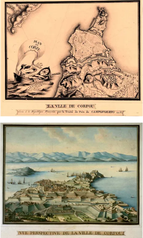
Fig. 1 – La cità di Corphu. Engraving with the general view of the new and the old city, not transformed into fortress (Georg Braun e Frans Hogenberg, Civitates orbis terrarum, Cologne, 1575).
4 For the implementation of the Vitelli plan see
Concina 1986, 80-192.
the entire settlement, including the ancient city definitively transformed into an enclosed citadel, and the adjacent Borgo and the external borghi (boroughs)4. They got started with the complete demolition of all the houses included in the ancient nucleus. Once the hill – where the early settlement stood – was flattened, an artificial canal was opened on its land side, so as to cut the Fortezza off from the rest of the city.
According to modern defence strategy, the military technicians were getting rid of everything standing in front of the Fortezza, so as to create an empty space called spianata o guasto. The massive use of artillery required, indeed, that all the buildings formerly located in the external zone be dismantled. Not by chance, the two Italian words spianata and guasto have sinister meanings, both indicating the flattening of any kind of constructions. Its purpose consisted of preventing any possible attack from the presumed weaker side of the system, that is the land. In case of a siege, the Ottomans would have been nearing the wall without any sort of physical protection. For the Venetian guns shooting from the bastions, it would be easy to sweep the entire space where the enemy troops were compelled to move. On the opposite side of the Citadel – or Fortezza Vecchia – stood the new power-ful line of defence which ran from west to east connecting the two coastal banks. It consisted of two parallel curtains encompassing the entire city on the northern side. It was enriched by a big fortress – the Fortezza nuova – located at one of its extremities, next to the flattened Mount Abraham. Finally, the defensive system looked locked-in and especially impregnable in case of a Turkish landing. Published in 1696, the map drawn-out by Vincenzo Coronelli shows the fortified Ionian city as it stood just before the Ottoman attack of 1716. Moreover, the layout perfectly
Fig. 2 – Vincenzo Maria Coronelli, Corfù, città
e fortezza, metropoli dell’isola di questo nome,
1692. Map with works of defence in the city of Corfu, as depicted in Atlante Veneto, nel quale
si contiene la descrittione geografica, storica, sacra, profana e politica degl’Imperii, Regni, Provincie, e Stati dell’Universo, 2. Venezia.
5 First drawn-out in 1593, the plan for Palmanova
makes the fortress city similar to a nine-pointed star. Such a singular shape is nothing but the result of the latest military innovations introduced in this century, designing here a new defensive complex. Of the three fortified circles, the first and second ones were executed at different times by the Venetians, whereas the third was carried out by the French at the beginning of the nineteenth century; see, on this matter, Fiore 2014, 221-239.
depicts the final result of the works begun in the sixteenth century, according to the Vitelli plan. As a result, the urban form of Corfu had been radically transformed, being schematically divided into three well-defined portions: on one side the “Cas-tellum” (or “Fortezza Vecchia”), on the other the “Civitas” (located in the space of the old Borgo) and in the middle the “Vacuum” (namely the Spianata or Guasto). After the creation of the huge bastion and the demolition of the surrounding set-tlements, the real city had shifted further beyond the external line of the guasto. Finally, the new urban bulk now stands some five hundred meters far from the place where the early urban nucleus stood. Next to the “new town” lies the renewed and enlarged port of Spilea (or Spilia), located in a protected spot and controlled by the new fortress. At its foot, a group of renewed and enlarged barracks was located in proximity of the harbour. Just in front of it, the island of Vido was strengthened in order to prevent a direct attack (if it were to occur) bypassing the fortified line of defense in Corfu. Later, in the eighteenth century, a colonnade street would be opened in order to create a direct connection between the harbour of Spilea and the urban core. Meanwhile, for those entering Corfu through the port area, an urban gate was realized according to Vitelli’s design. Its architecture was powerfully expressed and enriched by a long series of symbols (some obelisks and spheres, together with the unmissable Lion of Saint Mark) which had to show the
Serenis-sima “peaceful strength”.
A period of transition
Looking at the defensive project as a whole, we cannot but make a direct com-parison with the stronghold of Palmanova, realized by the Venetians in the same period5. Analogue is also the purpose on which the defensive works were built-up in the Ionian city: that is to oppose an impassable bastion to the Turkish expansion-ism. The first – located in the “Domini di terra” – has been designed in the form of ideal city on flat and empty land, eventually representing a perfect projection of modern theories about gunfire systems of defense. On the contrary, the design for the new structure of Corfu shows how the models of “arte militare” may be applied to a complex site and to a rough ground: an uncompromised application of an abstract scheme on the one hand, a careful process of adaption on the other. The two fortress cities are to be finally considered as good examples of the heights reached, at the turn of the sixteenth century, by military science in its architectural projections. Either pure or modified according to the circumstances, their models can also be applied on an urban scale, trying to make purpose and the need for defense coexist even in strongholds such as Corfu.
In 1716, once again, Corfu was put under siege by the Turkish forces from both the sea and land sides. The hero of the siege was the German general Johann Mat-thias von der Schulenburg. Also learning from these difficult circumstances, the
6 Concerning the post-1716 plan of establishing
a military school, see the file “Scuola Militare di Corfù” in Biblioteca del Museo Correr, Venice (BMC), Mss. Cicogna, 3104.
Serenissima officers were presumed to draw technical skill from what was carried
out in these difficult circumstances. Based on this simple concept, what had been carried out for the defence of Corfu should have formed the basis of new, sys-tematic knowledge. Moreover, the great effort made by experts was presumed to substantially contribute to the transformation of an empirical “arte militare” into a new science. Not by chance, in the years after the dramatic events of the early eighteenth century, Schulenburg set his mind on creating in situ a military school to be conceived as a means to overcome, in the long run, problems of defence6. As a first step, under the circumstances, he suggested to enroll as teaching staff the ten officers involved in the works of fortifying Corfu, namely the most besieged town of all the Venetian domains. A didactical nucleus would first be established in the following years, divided between Corfu and other places, such as Zante and Santa Maura.
In fact, the 1716 attack was the last one ever launched by the Ottomans on the Ionian stronghold. From a historical point of view, the siege would have been
con-Fig. 3 – Map with new system of defence, as suggested in Schulenburg’s plan, 1720 ca. ANK, Kolla Collection.
7 See the Relazione del Maresciallo di
Scolemburgo [sic] in rapporto alle fortificazioni di Corfù, 19 November 1737, in BMC, Mss.
Gradenigo-Dolfin, 200/XI.
8 For a description of the defensive system before
and after 1716, as indicated in maps and drawings stored in the Venice Library, see Molteni and Moretti 2010, 81-98.
9 See the many Dispacci sent by the “Provveditori
da mar”, located in Corfu, between 1717 and 1797. These dispatches are included in the general file of Archivio di Stato di Venezia (ASV) “Provveditori da terra e da mar e da altre, 1500-1797”. See in particular “Dispaccio del Provveditore da mar Loredan, 1742-43” in ASV, Senato 988 (b.662).
10 See the Report of 1751 quoted in Bacchion 1956,
195.
11 All these maps are stored in BMC, Gabinetto
di Cartografia: see Giovanni Battista Bragadin,
Dissegno topografico della città di Corfù con le fortificazioni nuovamente erette. Dedicato […] ad Andrea Tron, Mss. P.D. c842/5; Pianta della città e forteza di Corfù […], 1753, Archivio De
Lazara Pisani Zusto, cass 1/12; Ganassa, Pianta
della città e fortezze di Corfù e suoi sotteranei,
by Giovanni de Honstein, Mss. P.D. c842/4. Maps and related keys are reported in Romanelli and Tonini 2010, 109-122.
sidered the maritime equivalent of the most famous one, which occurred in Vienna thirty four years before. Eventually, both Vienna and Corfu represent the extreme attempts by the Turks to violate the gates of Europe. But, at that time, the poten-tially besieged population – both civil and military – was not conscious of being the last eye-witnesses of the last siege. Theoretically, the process of reinforcing and renewing had not yet come to an end.
Even after 1716, stress was still put on the problem of defence. Despite successful conclusions, Schulenburg suggested a series of improvements and enlargements of the system of bastions in order to better cope with another possible attack by the enemy7. His plan was based on doubling the defensive front line and con-structing two new fortresses on the land side, together with the creation of an underground network of tunnels which could connect all the three fortified spots. Another external borough – that of San Rocco – was cleared out and the nearby hill flattened, in order to supply the Venetian artillery with a clear view onto a totally empty space. Further afield, in the small Corfiot bay of Gouvia, the navy created a new arsenale with docks for recovering battle-ships, and a second complex was located at Argostoli in the Island of Cephalonia. Being both unprotected, the two navy bases could be used in peace time only.
Apparently, the defence project and their addenda fully represent the execution of what was traced and realized in the seventeenth century plans, for enforcing the defensive capacity of the system8. In fact, what became evident – in the first half and even more so in the second half of the century – was a progressive disinterest in fortifications. The local representatives sent the Serenissima a series of alarmed dispatches, referring not only to the missed implementation of the enforcing plan, but also to the inadequate maintenance of the existing structures9. The procuratori especially complained about the lack of governmental concern and financial sup-port for strengthening – at least – the strategic role of maritime hub that Corfu had to play in the overseas domains. Even if the Ottoman threat was fading away, they did not want any sort of Turkish boat to have the chance to approach the Ionian harbour. Otherwise, the enemy would be able to monitor how weak and badly kept the fortifications were looking at that time. The former stronghold of the Gulf of Venice – they said – was no longer locked out. Due to its present conditions, it could be violated at any time and by any kind of naval force10. At that time, however, the Ottomans did not dare to organize any attack. The age of sieges had forever expired.
It was not only the official reports that were revealing an increasing process of de-militarization. Take for instance the two outstanding topographic maps drawn out by Bragadin/Honstein and by Ganassa, both published in about 1750. We could get contradictory impressions from each of them11. At first sight, Corfu still looked like a powerful war-machine endowed with dissuasive strength. Looking deeper, however, we can perceive a creeping process of transformation: starting from the
guasto and its progressive adaptation to civil uses, being transformed from an
mid-eigh-teenth century, long before the transformation of the spianata into the Esplanade, some eye-witness perceived it as a large and atypical “square”: the only one in a very dense city that did not have “adequate spaces”, as observed by some trave lers
Fig. 5 – Vue perspective de la ville de Corfou. Perspective view drawn-out by the French Royal Engineers, 1797. ANK, French Republican Collection.
Fig. 4 – La ville de Corfou. Perspective view drawn-out by the French Royal Engineers, 1797. ANK, French Republican Collection.
12 Description of the most significant projects
and interventions in eighteenth-century Corfu in Zucconi, forthcoming.
13 The “Provveditore da mar”, of Giorgio Grimani,
talks about the civil hospital in a dedicated dispatch on November 1738, suggesting a location next to the military one, ASV, Senato 983, b.653. For the project drawn out by Paolo Artico, see the two plates Pianta piano terreno e due piani
inferiori del costruendo ospedale per infermi e poveri d’ambo i riti e i sessi, 1 December 1795,
ASV/P.T.M, F.1056.
14 Plates and records concerning the military
hospital are stored in BMC, Gabinetto di Cartografia, 7/Ms PDc 859/16, CI.XLIVb; see, in particular, plate no. 0892 Pian Terreno
dell’Ospedale militare di Corfù.
15 See Relazione del Maresciallo di Scolemburgo
[sic] in rapporto alle fortificazioni di Corfù, 19
November 1737, BMC, Mss. Gradenigo-Dolfin, 200/XI.
of the time. On the map, we can clearly seelines corresponding to the paths which would soon be turned into promenades. This network of lines testifies to civil – and not just military – connections between the inhabited center and the Old Fortress. At the junctions of the trails, there are focuses and points where the British would set up a series of celebratory statues and small temples in the early twentieth century.
Some eighteenth-century architectural episodes would have foretold another role for the Spianata, by giving it a new centrality12. These are the two hospital pro-jects: the first drawn out in 1738 as a military facility, the second destined for the civilian population13. Conceived almost simultaneously, but designed later, they were located near San Nicolò gate, at one end of the future Esplanade. The spot was not far from the place where, during the first British period, the San Michele and San Giorgio Palace would be erected. The military hospital had to come out of the restructuring and expansion of existing structures14, while the civilian one corresponded to an ex-novo project to accommodating both the sick and the poor. These two functions are usually housed in distinct ad hoc designed containers. Even in this case, to be precise, there was a defensive motive associated with one of Schulenburg’s suggestions. In his post-siege plan, he had hoped that, in the event of another devastating attack, the civilian population would be admitted to special places where they would not interfere with the assistance of the injured soldiers15.
There are no doubts about the ambitions of the plan drawn out by the German mar-shal, who wished to turn the Adriatic gate into an impregnable system of defence. Nevertheless, the eighteenth century would represent the “continental divide” between a period dominated by military concern and a subsequent phase when the stress would be slowly but progressively shifted onto the building of civil infra-structure, such as schools, governmental offices, commercial outfits, hospitals and even university buildings. One hundred years are in fact too many to be considered as a real watershed between two stages. Especially if considered from a Corfiot standpoint, the question to be posed is therefore: when could we set the real cae-sura between two radically different ways of perceiving the role of fortifications?
Between Venice and Britain
What gives us the perception of an increasing change – from military to civil des-tinations – is the comparison with previous maps such as the one elaborated by Vincenzo Coronelli more than fifty years earlier. His plates only show a suite of forts and lines of fortifications, whereas the city is nothing but a blank area. Such an attitude cannot be justified by the status of Coronelli, as officer of the Venetian army; even Bragadin and Ganassa were military servants. In both the maps drawn out in the middle of the seventeenth century, the detailed keys better reveal an
16 According to the Paris Treaty – later
incorporated into the Vienna Treaty –, the new Ionian State was put “[…] under the immediate and exclusive protection of the King of Great Britain” (art. II), which is called “[…] to regulate their internal organization” (art. III). In order to implement the Treaty and to create a suitable Governmental structure, the King will appoint a High Commissioner (art. IV). Cf. MacGachen 1859, 12-13.
17 Reported in Goodisson 1822, 31.
18 The data refers to the period 1824-1831 only
(Jervis 1863, 78).
19 The most generous estimate comes from
Goodisson (1822, 29); the other is made by de Saint-Vincent (1823, vi).
incoming strategy of adapting the former military outfits to civil uses. This occurred especially in the area next to the Porta San Nicolò – the future seat of the British High Commissioner – where a nucleus of the first civil functions was being created at that time. Moreover, new projects for new civil buildings were carried out dur-ing the eighteenth century, absorbdur-ing a large amount of attention and financial resources. First came the rationalization of the area of Spilea, together with the creation of commercial outfits.
The process of demilitarization was, however, not of a linear kind. Rather, it was characterized by a series of stop and go revealing a contradictory attitude. Take, for example, what occurred after the earthquake of 1783. In the face of the recon-struction work, the procuratori were required to give priority to fortifications. Refurbishing the defensive walls and rebuilding the forts had to come first, and only after that came the repairing – and the remaking from scratch – of housing. A few decades later, the new British rulers would do the opposite, providing precedence to civil functions at the expense of the defensive works.
The great political turnover occurred in 1814. Signed in May, the Treaty of Paris sanctioned the passage of Corfu to Great Britain, together with the other six Ioni an islands16. Put under British control, the new protectorate took the name of
Heptane-sus, and was ruled by a High Commissioner appointed by the Minister for Overseas
affairs. Together with Gibraltar, Cyprus and Malta, the Heptanesus became part of a new system of maritime strongholds. This spotty crown of naval bases were called to warrant the Pax Britannica – together with military control – over the space of the Mediterranean. In this new context, Corfu lost its traditional role of cardinal point between the “Gulf of Venice” and the open sea, acquiring that of “fortified junction” in the the British fleet’s job to control the entire Mediterranean. However, the city had to maintain the status of “garrison city” despite the progres-sive loss of its strategic relevance. As an epitome of its new condition, a British medical officer affirmed in 1822: “We could consider Corfu as being impregnable, if there were ever the need to it take by force”17. But nobody at that time presumed to express such a necessity; especially the Ottomans, engaged in the defense of the borders of what remained of their Empire in the Balkans. To justify the rel-evant amount of expenses, the new rulers had to present themselves as “defen-sor Corcyrae”, even if there was a clear disproportion between the effective role of the supposed stronghold and what was deemed necessary to keep it in good conditions. This was especially the case concerning the British Parliament which was required to pass a bill of 154,000 pounds for a seven-year program of repair-ing the fortifications18.
Between the military garrison and the civil population, a further disproportion becomes increasingly evident. On the one hand, the city and its surroundings had between 13,500 and 17,000 inhabitants, on the other, British command estimated that from ten to twenty thousand were needed to keep the stronghold19. Eventu-ally, what emerges from this kind of analysis is a one-to-one relationship: a patho-logical condition if compared to the loss of strategic function. A large portion of
the urban vicissitudes of contemporary Corfu could therefore be framed into this disproportion between the theoretical role of a fortress town and the increasingly weak conditions of the defensive equipment. Among these contradictions, the new rulers insinuated the project for a small capital city.
The strategy of the British representatives seemed to be based on a minimal con-cern for defensive works. Once the role of garrison city and the maintenance of its defensive outfits were ensured, they had to direct the bulk of resources towards the erection of a new prestigious – albeit tiny – capital city. While large portions of the defensive works had to be – partially or totally – demolished, another set
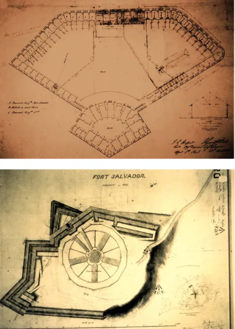
Fig. 6 – Plan with the suggested military prison in the former bastion of Vido, drawn-out by the British Royal Engineers, 1846. ANK, Kolla Collection.
Fig. 7 – Plan with the suggested civil prison in the Fort San Salvador, drawn-out by the British Royal Engineer C. Crawford, 1860. ANK, Kolla Collection.
20 On his life and work, see Frewen 1897, II, chap.
12-17, for his Ionian period.
21 The most detailed description of what was done
by Adam during his time in office is in Napier 1833.
of buildings would be turned into public facilities, such as hospitals, schools and governmental offices. Eventually, only a smaller portion could be re-used for mili-tary purposes.
The first High Commissioner was Thomas Maitland20, whose name is mainly associ-ated with the building of the Palace of Saint Michael and Saint George, which was originally conceived to house the supreme representative of the British govern-ment. Then came Frederick Adam; in the national budget, he increased investments in public works, to the disadvantage of those related to the military sector. If we exclude the buildings around the Esplanade – including the Governor’s Palace –, it can be said the program for “Corfu capital” only began to take shape after 1824 and to be implemented in the following decade. Throughout the eight years he was in office, Adam emphasized two main areas of investment21: the establishment of a school system, including a new university, and the construction of the aqueduct, which was intended to intercept the waters of the Potamos river at its source and serve the whole city, after being transported a distance of seven miles. For this
Fig. 8 – Plan with the suggested lunatic asylum in a former bastion, drawn-out by the British Royal Engineer A. Giroud, 1856. ANK, Kolla Collection.
22 Such an inscription is usually reported on all the
plates of this period, now stored in the National Archives, Corfu (ANK), Collection D. Kolla.
project, accomplished in 1831, he would later be celebrated and commemorated with the bronze statue surrounded by water in the middle of the Esplanade. Adam also promoted the creation of the first university – the so-called Ionian Academy – which was temporarily housed in the Baracks Grimani, built in 1725, only one hundred years previously, along the southern edge of the Spianata.
Towards the dismantling
of the stronghold
Barracks transformed into a university building: this is but one of the episodes of functional re-use which have characterised the story of Corfu as capital of the Heptanese. Within the budget for defensive work, the major part was absorbed by the expenditure on restoration and demolition of walls and portions of fortresses. In this period, the weight of military bodies continued to be relevant; more or less evidently, it was in any case of a pervasive nature. Significant buildings – such as the aforementioned seat of the Ionian University – were usually designed by the Royal Engineers, while minor projects of ordinary adjustments would be delegated to local professionals or architects of the civil administration. In addition to the major architectural episodes, the army was controlling all the works of construction, transformation and renewal within the city limits. For approval, any project had to be stamped with the formula “the building in question can be erected without any prejudice to the fortifications”22. Initially, the problem was related to projects located close to the defensive works. Then, starting in 1825, the principle would be extended to all cases of public and private construction.
This corresponded to a period of building expansion and, paradoxically, the increase in military control went hand in hand with the progressive dismantling of the works of fortifications and their conversion to civil ends (prisons, schools, hospitals, asylums). Restoration was restricted to the fortified perimeter in order to confirm the status and physiognomy of a presumed stronghold. On the other hand, it went further in abandoning, demolishing or reconverting the adjoining elements of the defensive system such as ramparts, bastions, and other advanced portions of the wall system.
This process of reconversion was followed by a set of operations in areas once occu-pied by defensive works: the abolition of military servitude, the transfer of land to the municipality, the leveling of elevated areas. It also involved the disposal of all extra-urban strongholds created in accordance with the Schulenburg plan, such as S. Rocco, S. Salvador, Abraham and their substitution with buildings dedicated to civil functions. Located in front of the port, the island of Vido represents an exception in this panorama, as its fortress was strengthened in order to prevent a direct attack on the harbour. Indeed, British military command took special care
23 On the Napoleonic period, see Lunzi 1860. For
a French perspective on Corfu in the nineteenth century, see Lenormant 1865.
24 On the construction of the new Heptanese
capital, see Zucconi 1994.
with any problems associated with maritime defence. Only later would they reserve for Vido, not a destiny of radical demolition, but a plan of substantial reduction and adjustment in order to house the unsanitary asylum.
There was no general plan but several specific programs for reshaping and adapt-ing fortifications. In fact, they provided the only opportunities for a large-scale reflection on urban form, including the relationships between residence and service facilities. In other words, the plans for reducing the defence system would play a vicarious role in Corfu over a general building plan that the High Commissioners had not drawn out for the capital of the Ionian state.
The downgrading of the Ionian stronghold was first associated with the withdrawal of the Ottoman Empire, and secondly with the decline of the Republic of Venice. A turning point corresponded with the final collapse of the Serenissima (1797) which introduced a totally different framework from both a political and strategic point of view. The full perception of the crisis came, however, after the Napoleonic wars which had, for the last time, provided Corfu with a strategic role. After 1814, what had been hitherto considered a powerful stronghold against the enemy was in part regarded as a useless and cumbersome structure. At the same time, in the new Adriatic geography emerging from the Congress of Vienna, a secondary maritime role was now assigned to the Corfiot hub, traditionally considered as the gate of the former “Venetian Gulf”.
The best example of the process of demilitarization was the full transformation of the former Spianata into the “Esplanade”. During the Napoleonic period, this space was officially devoted to the function of Champ de Mars. Fort-Neuf was the new name which would forever replace the old Venetian term, Fortezza Nuova23. Later, in its transition to British rule, the previous “raison d’être militaire” of this empty space was progressively replaced by a concept based on representativeness and leisure: a pleasant and architecturally significant space which was highly expressive of the new status of the capital city24.
A sort of new city was growing up around this zone dedicated to greenery and public leisure. The space was dominated by alternative values to those prevailing in the old city. There was a healthy and geometric order, in contrast to the cramped and labyrinthine aspect of the Greek town. Already in 1822, such was the image of this space offered to potential visitors:
“The only part of the town of Corfù worthy of description or notice is the Es-planade […] a delightful green, which extends between the town and the ditch that separates the fortress from it. A good gravel walk with a double row of trees at each side, unites the fortress to the town.” (Goodisson 1822, 32).
This highly representational space would be occupied not only by the seats of the new Ionian state – such as the Palace of the High Commissioner, the university, the San Giorgio temple, and memorials, such as the those dedicated to Maitland and Adam –. Trade and commerce would also be represented and materialized on one
of its main sides. Beginning with the French domination and completed under the British rule, a series of relatively big buildings were erected at the limits of the old
Spianata, providing a backdrop of a hitherto unexpected amount of architectural décor. The new blocks look like something in between Paris and Venice, housing
a suite of cafés and elegant shops under the high vaults of the porch. The atmos-phere was supposed to be the same as Paris, but the name – “Liston” – and the style of the façade recall the character of the former “Dominante”, that is Venice.
The creation of a capital city
There is a high degree of continuity in the architectural character of the fronts built up in the late eighteenth century and in the following phase, during the Venetian and the Heptanese period. The building boom – that accompanied the capital of a new state – in fact echoed the image of an eighteenth-century city, due to a preva-lence of models, which if not Neo-Palladian, were at least linked to the previous phase. This applies to smaller buildings but also to the most significant architectural episodes, starting with the façade of the Kapodistrias palace, completed in 1840. Its creator – the Corfiot architect Joannis Chronis – was a pupil of the Italian sculptor Antonio Canova, and had followed a course similar to other Venetian colleagues. Back in his homeland in 1831, Chronis would be active in subsequent decades, but his stylistic background refers to a Venetian koiné that would be visible on the façades of the buildings for a long time.
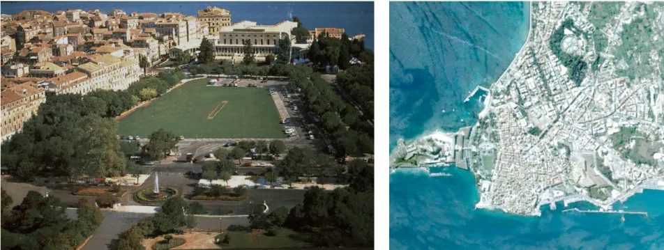
Fig. 9 – A today bird’s-eye view of the Esplanade in Corfu. Courtesy of the Tourism Office of Corfu.
Fig. 10 – Zenithal view of the city of Corfu. Courtesy of Google Earth.
25 On the life and work of Whitmore, see Colvin
1978, 886.
26 Criticism would have sprung from the pages
written by colonel Charles J. Napier, ex Resident in Cephalonia (Napier 1833, 178).
The architectural masterpiece of this period is no doubt the Palace of Saint Michael and Saint George, which frames almost the entirety of one side of the Esplanade (Dimacopoulos 1979, 356-359; 1994,105-111). It was designed in 1818 by a British Royal Engineer named George Whitmore25. In this big construction, everything came from Malta, including the tufaceous stones, the building masters, the brick-layers and even its creator. The splendid seat was finished in 1823 at a total cost of £45,000 (Napier 1833, ix). It was inaugurated several months before the death of Sir Thomas Maitland, which occurred in 1824. After laying the first stone, the High Commis-sioner decided to annex a new wing, suitable for the seat of the Ionian Parliament. The reason to diverge from the earlier plan was probably due to further enhance the prestige and role of the big building in the local context. With its long rows of Doric and Ionian columns, its monumental pronaos leading to the big hall, the Ionian Palace sums up elements of the Neo-Greek style, eventually resembling an English country residence such as those designed by John Nash. Not only in its style, but also in its dimensions and proportions, the Ionian house of the High Commissioner and of Parliament seems to anticipate what the German and Danish architects would design, in the span of a decade, in Athens, the new capital city of the Greek Kingdom. In the aftermath, he would be bitterly criticized for the disproportionate grandeur of the palace26.
In the local context, the construction of the Palace of Saint Michael and Saint George also marked a substantial shift of emphasis from the urban limits of the city onto its most prestigious core, the completely renovated Esplanade. Flows of financial commitment would of course follow the changing attitude associated with the new rulers. After the works brought about in the 1830’s, the new capital city showed no other defensive elements but the Fortezza Vecchia and a small portion of the old perimeter. What appears to have been dismantled was the whole internal section of the Venetian wall between the bay of Garitsa and Fort-Neuf. This rupture paved the way for future urban expansions, also providing guidelines for building developments. In this part of the city, affected by future plans of enlargement, the remains of strongholds and bastions were partially converted into collective equipment. In this new context, the prison and hospital stood in anticipation of a modern city to be defined in the near future.
The general problem of designing urban expansion would only be tackled in a systematic way after the annexation to the Kingdom of Greece. On March 1864, according to the Treaty of London, the Union Jack banner was lowered, to be replaced by the flag of Saint Andrew’s Cross. Before leaving the city, the Royal Engineers planted mines to demolish the remaining external defenses. From then on, no physical obstacle could prevent urban growth, and the new rulers drew up a series of schemes centered around the flattened hill of San Rocco (now Saint-Roch). With this name, they created a new square representing the focus of urban expan-sion. The square marks the convergence of a network of geometrically arranged roads inspired by a kind of Neo-Hellenic style on an urban scale.
27 Reported in Old Town of Corfu 2012, 6. The
inscription (file no. 978/2007) followed the submission and adoption of the Management Plan for the monuments. Within this framework, an import role is played by the preservation of defensive works to be considered as a fundamental portion of the whole.
With the annexation to the Greece, the short story of the Ionian capital comes to an end. Finally, in modern times, Corfu would present a radical new townscape due to the progressive decalage of its strategic significance and military, political and trading role. What emerges now is a new urban concept associated with the incoming demand for tourism. What would grow, during the twentieth century, was the interest for the old town of Corfu which would be inscribed in 2007 in the UNESCO World Heritage List. The inscription was justified on the grounds that “[…] the urban and port ensemble of Corfu, dominated by its fortresses of Vene-tian origin, constitutes an architectural example of outstanding universal value in both its authenticity and its integrity.”27.
In its current state, the urban and defensive ensemble is, however, the outcome of a process of transformation which has slowly taken place over the long term, with a sudden acceleration in the period between 1797 and 1864: from the collapse of Venice to the annexation to the Kingdom of Greece. In between this was a deter-minant stage corresponding to British domination, whose end is marked by the departure of the last High Commissioner. The renewed and embellished “Esplanade” can therefore be considered the perfect epitome of a fortress town tranformed into a place that is fully representative of its new functions: first of a capital, then of a leisure city. From a city en garde, as it was conceived in Serenissima times, Corfu would become an open city. In the transition from the modern to contemporary epoch, the remains of the fortification stand only as the last and lonely witnesses of an apparently remote past.
•
Bibliography
Bacchion, Eugenio. 1956. Il dominio veneto su Corfù: 1386-1797. [Quarto d’Altino]: Ed. Altino.
Bonardi, Claudia. 2005. “Gli anni settanta: il soprintendente Vitelli, un bombardiere e un ingegnere di acque”. In Fortezze “alla moderna” e ingegneri militari del ducato
sabaudo, ed. Micaela Viglino Davico, 287-293. Torino: Celid.
Bonardi, Claudia. 2007. “Ferrante Vitelli, cavaliere pontificio e ‘colonnello’ dei Savoia nei giorni di Corfù (1576-1578)”. In Gli ingegneri militari attivi nelle terre dei Savoia
e nel Piemonte orientale, ed. Micaela Viglino Davico and Andrea Bruno Jr., 33-49.
Firenze: Edifir.
Colvin, Howard. 1978. A Biographical Dictionary of British Architects, 1600-1840. London: Murray.
Concina, Ennio, 1986. “Città e fortezze nelle ‘tre isole nostre’ del Levante”. In Venezia e
la difesa del Levante: da Lepanto a Candia, 1570-1670, ed. Ennio Concina et al.,
180-192. Venezia: Arsenale Editrice.
Concina, Ennio, and Aliki Nikiforou, eds. 1994. Corfu, History, Urban Space and
Architecture: 14th – 19th cent., Catalogue of the Exhibition (Corfu, July-Sept. 1994).
Concina, Ennio, 1994. “St. Mark, the Stonghold, the Town”. In Concina and Nikiforou, 29-37.
Dimacopoulos, Jordan. 1979. “Whitmore of Corfu”. The Architectual Review 166 (994): 356-359.
Dimacopoulos, Jordan. 1994. “The Palace of Saint Michael and Saint George”. In Concina and Nikiforou, 105-111.
Di Rocco, Maurizio. 1978. Corfù, le fortificazioni e la città dal 1386 al 1669. Diss., Università degli Studi di Firenze.
Fiore, Francesco Paolo. 2014. “Palmanova e la fortificazione in terra”. In L’architettura
militare di Venezia in terraferma e in Adriatico fra XVI e XVII secolo, ed. Francesco
Paolo Fiore, 221-239. Firenze: Olschki.
Frewen, Walter, ed. 1897. “Sir Thomas Maitland. The Mastery of the Mediterranean”. In
Builders of Greater Britain, 2 vol. London: T. Fisher Unwin.
Goodisson, William. 1822. Historical and Topographical Essay upon the Islands of Corfù,
Leucada, Cephalonia, Ithaca and Zante.... London: Underwood.
Jervis, H.J. 1863. The Ionian Islands during the present Century. London: Chapman. Lanfranchi, Fausto. 2016. “Conflitti e ‘dispareri’ tra ingegneri militari per la progettazione
della fortezza nuova di Corfù nella seconda metà del Cinquecento”. Archivio Veneto 11: 67-109.
Lenormant, François. 1865. La Grèce et les Iles Ioniennes. Etudes de politique et d’histoire
contemporaine. Paris: M. Levy.
Lunzi, Ermanno. 1860. Storia delle Isole ionie sotto il reggimento dei Repubblicani francesi. Venezia: Tip. del Commercio.
MacGachen, Frederic Stewart. 1859. The Ionian Islands: a Sketch of their past History with
reference to their Position under our Protectorate. London: James Cornish.
Molteni, Elisabetta, and Moretti, Silvia. 2010. “Mappe e disegni riguardanti Corfù nella Biblioteca del Museo Correr”. In Romanelli and Tonini, 81-98.
Napier, Charles James. 1833. The Colonies. Treating of their Value generally. Of the Ionian
Islands in particular […] Structures on the Administration of Sir Fredrick Adam.
London: [s.n.].
Old Town of Corfu, UNESCO World Heritage Site. Proposal for the Update of the Management Plan. 2012. Corfu: Culture Polis.
Romanelli, Giandomenico, and Camillo Tonini, ed. 2010. Corfù “Perla del Levante”.
Documenti, mappe e disegni del Museo Correr. Milan: Biblion.
Saint-Vincent, Bory. 1823. Nouvel Atlas pour servir à l’histoire des Iles Ioniennes. [In]
Histoire et description des Iles Ioniennes..., ed. Baron V. A. von Schneider. Paris:
Dendy-Dupré.
Zucconi, Guido. 1994. “Corcyra Britannica. Architecture and Urban Strategies in the Capital of the Ionian State”. In Concina and Nikiforou, 95-103.
Zucconi, Guido. 2001. La città dell’ Ottocento. Venezia: Laterza.
Zucconi, Guido. Forthcoming. “Dopo Schulenburg: aspetti dell’edilizia civile e problemi di riassetto urbano”. In The Ottoman Siege of Corfu in 1716. Proceedings of the