1Instituto de Geociências, Universidade de São Paulo – USP, São Paulo (SP), Brazil. E-mail: lucas.martins.santos@usp.br, franciscocavallaro@usp.br, srfvlah@usp.br, daniel.coelho@usp.br
2Departamento de Engenharia Civil, Universidade de São Paulo – USP, São Paulo (SP), Brazil.
*Corresponding author.
Manuscript ID: 20170099. Received on: 07/18/2017. Approved on: 12/02/2017.
ABSTRACT: The Limeira Intrusion is an occurrence related to the Mesozoic continental flood basalts of Paraná Magmatic Province, cropping out at the eastern São Paulo state. It is made up of basic-intermediate rocks with a great diversity of structures, textures and modal compositions, related to specific evolutionary process in a magma chamber. Previous geological and stratigraphic evidence suggests it has a lopolithic-like geometry rather than a conventional sill-like, assumed for most regional similar occurrences. 2D forward modeling of magnetometric data, based on available aerial and newly obtained ground data integrated with in situ rock magnetic susceptibility measurements, were used to test such hypothesis. The results, even considering intrinsic drawbacks of magnetometric theoretical models, are compatible with the geologic-based presumed intrusion geometry. The determination of intrusive bodies geometry is quite significant to explain their different emplacement mechanisms. In the case of Limeira Intrusion, the results suggest that the emplacement mechanism may occur, apparently, by inner-accretion of fresh magmatic pulses in its central region. Importantly, the magmatic evolution of lopolith-like basic-intermediate intrusions may open the way for extensive differentiation processes, with strong implications to petrology and metallogenesis.
KEYWORDS: Limeira intrusion; Intrusion geometry; 2D magnetometric modeling; Lopolith; Paraná Magmatic Province.
2D magnetometric modeling of a
basic-intermediate intrusion geometry:
geophysical and geological approaches
applied to the Limeira intrusion,
Paraná Magmatic Province (SP, Brazil)
Lucas Martins Lino1*, Francisco de Assis Cavallaro1,2, Silvio Roberto de Farias Vlach1, Daniel Cunha Coelho1 ARTICLE
INTRODUCTION
The formation and geometry of igneous intrusions in the crust are still a subject of debate in the literature due to their diverse forms of occurrence and to a great amount of tec-tonic environments in which they occur. However, recently, the formation and growth of igneous intrusions have been associated to the amalgamation of several tabular-like intru-sions (Cruden 1998, Menand 2011). The simplicity, larger distribution and relatively small volumes, as compared with batholiths, turn tabular intrusions an object of preferential study when dealing with igneous bodies emplacement and thermal evolution.
Geophysical modeling is an important tool, which allows defining the geometry of several geologic occurrences. The magnetometric method, despite being a relatively more complex potential one, is a very efficient technique in the detection of geological occurrences with high magnetic sus-ceptibility contrast in relation to their environments (e.g., Kearey & Brooks 2002).
The magnetization intensity of a rock strongly depends on the modal volume and magnetic characteristics of its miner-als. For instance, magnetic anomalies produced by a 200 m3
body can be the same as those produced by a 2 km3 body,
may lead to misinterpretation when dealing with magnetic anomalies; however, there are ways to circumvent this prob-lem, based on well-designed previous geological models and the knowledge of the targets magnetic properties.
The continental crust presents internal stratification associated with variations of the constituting rocks physi-cal properties, as so far indicated by geophysiphysi-cal data and theoretical models based on indirect observations. As well known, the crust is constituted, at least, by two main lay-ers, a deep one composed of mafic rocks (lower crust), and a shallow one of granitic composition (upper crust) (e.g., Rudnick & Fountain 1995). This type of stratification could not be explained by considering only the emplacement of vertical intrusions. In fact, available seismic data reveal the occurrence of intrusive complexes made up of tabular intrusions at the base of the continental crust, which could be likely mechanisms for the formation of different crustal layers (Franke 1992).
The present work aims to provide geological and geophysical information about the geometry of Limeira Intrusion, a tabu-lar-like occurrence related to the Mesozoic Paraná Magmatic Province (PMP), in southern Brazil. Although the province has been extensively studied concerning its stratigraphy, petrogra-phy, elemental and isotope geochemistry, and geochronology (e.g., Bellieni et al. 1984, Ernesto & Pacca 1988, Piccirillo & Melfi 1988, Peate 1997, Gallagher & Hawkesworth 1994, Nardy et al. 2003, and references therein), which allowed to draw several petrogenetic and tectonic models (e.g., Peate et al. 1992, Turner & Hawkesworth 1995, Peate & Hawkesworth 1996, Peate 1997), there is still few detailed geological and stratigraphic research emphasizing the physical and geomet-ric aspects of individual intrusions or lava flows.
Previous semi-detailed geophysical studies by Seixas et al. (2015) showed that the Limeira Intrusion has a more limited lateral spreading than previously considered. In addition, previous geological studies give some support for a lopolith-ic-like intrusion form (e.g., Lino 2015). Herein we present the results obtained through a more detailed ground netometric survey, coupled with geological and rock mag-netic susceptibility data.
GEOLOGICAL FRAMEWORK
The PMP, southern Brazil, represents the most important Mesozoic continental flood basalt expression, constituting the Serra Geral Formation, one of the uppermost formations of the Paraná Basin (Bryan & Ernst 2008, Milani 2004). Over 562,000 km3 of lavas (Frank et al.2009) were erupted
in a time span between ca. 133 and 119 Ma (Brückmann
et al. 2014).
The majority of lavas are tholeiitic basalts, associated with minor andesites, riodacites and rhyolites, these later repre-senting only ca. 3% of the lava flows and occurring mainly in the southern Paraná Basin area (Comin-Chiaramonti
et al. 1988, Nardy et al. 2002). These lava flows comprise low-Ti geochemical types, which crop out in the base, while high-Ti varieties appear at the intermediate and the upper-most levels of lava sequences (Peate et al.1992).
The origin of the PMP is certainly related to the opening of the South Atlantic Ocean, through the process of litho-spheric mantle melting under the influence of the Tristan da Cunha Plume (Peate et al. 1990, 1999, Hawkesworth et al. 1992, Turner & Hawkesworth 1995, Marques et al. 1999) or, alternatively, to heat accumulation under the Pangea Supercontinent (Hartmann 2014).
In the eastern area of the São Paulo State, the high-Ti PMP magmatism is characterized by tabular-shaped intru-sions, such as dikes, sills, and laccoliths (Zalán et al. 1986). Most dikes intrude basement rocks and form expressive dike swarms (Peate et al. 1992) while the emplacement of sub-horizontal tabular intrusions occur mainly in sedimen-tary host discontinuities; estimated total thickness of such intrusions vary in general between 2 to 200 m, but may reach up to 1,000 m (Marques & Ernesto 2004).
Limeira Intrusion
The Limeira Intrusion is one among several PMP intru-sions that crop out in the São Paulo State central-eastern area (Fig. 1). It intrudes Permo-Carboniferous sedimentary rocks, mainly sandstones and rhythmic siltstones, of the Itararé Subgroup (Faria 2008, Lino 2015). The best fresh-rock expositions are found in the so-called Cavinatto, own-er’s family name, and Basalto 4 quarries. Soares (1985) were the first to recognize a huge intrusion at this region, named as the Limeira-Cosmópolis Sill. According to him, it would correspond to a tabular shaped intrusion, with almost 60 km of horizontal extension and 280 m of thickness, as suggested from surface evidences and available drill holes.
Several recent works, emphasizing petrological, geochem-ical, stratigraphical and geophysical aspects, were conducted by Faria (2008), Oliveira & Dantas (2008), Lino (2015) and Seixas et al. (2015), among others, and highlighted some features relatively uncommon to other intrusion analogs. One of us, Silvio R. F. Vlach, had pointed out the occurrence of typical stratiform-like rocks at the medium-to deep-out-crops at the Cavinatto quarry, given by modal and textural centimetric- to decimetric-thick igneous layering.
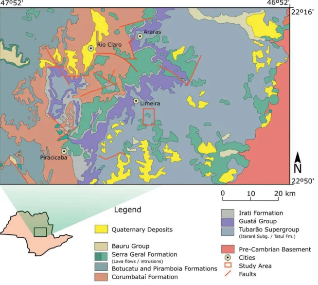
Figure 1. Geological map of central-eastern São Paulo state (Brazil), showing Paraná Basin stratigraphic Units, the pre-Cambrian basement and location of the study area. Rocks of the Tubarão Supergroup (Itararé Subgroup)
constitute most of the country rocks for the intrusions related to PMP magmatism. Simplified from Perrota &
Salvador (2005).
mm- to cm-sized thickness, cutting across monzodiorites and diabases, and as cm-sized ocelli in the upper diabases.
The main rocks are composed of plagioclase (An65-30), clinopyroxene (augite and pigeonite), Fe-Ti oxides (ilmen-ite, magnetite), and some sulfides. Apatite is the main acces-sory mineral. Well-developed granophyric intergrowths, composed by alkali-feldspar and quartz, are typical in the coarse-grained rocks mesostasis, amounting up to 23% vol. Hydrothermal processes are evidenced by apophyllite-bear-ing late veins, interstitial low-temperature minerals precip-itation, and substitution reactions affecting the primary mineral phases (Faria 2008, Lino 2015).
Both Faria (2008) and Oliveira & Dantas (2008) noted the intrusion’s bottom edge exposed at the Basalto 4 quarry
site, and proposed that it becomes thinner to southeast. Based on ground magnetometric survey and analytical signal amplitude profiles, Seixas et al. (2015) suggest that there are two independent intrusions in the Limeira area rather than a single sill: the first corresponds to the Limeira Intrusion itself, while the second (exposed at the Sertãozinho quarry) is another intrusion located in the southern area of Limeira city.
DATA ACQUISITION
AND TREATMENT
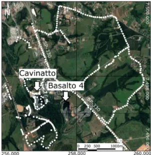
Magnetometers (Gem System, models GSM-19), with coupled high-precision GPS systems, in 516 field stations. One of them was used for diurnal variation measurements on a fixed station far from potential anthropogenic influence, while the other was used as the rover station. The average distance between two successive measurement stations was about 30 m (Fig. 2).
Magnetic susceptibility (MS) data were obtained for 57 rock samples. The measurements were made on regular surfaces or slices of fresh hand samples with portable equip-ment from GF Instruequip-ments. On the average, ten measure-ments were taken on each sample. In the studied rocks,
the MS values are directly correlated with the magnetite/ Ti-magnetite modal content.
Data processing and treatment procedures are summa-rized in Figure 3 (see also Cavallaro 2013, Milsom 2003). The TMF values, registered on the base and rover stations, were imported into the Geosoft´s Oasis Montaj® software and corrected for the diurnal magnetic variations and the International Geomagnetic Reference Field – IGRF (http:// www.ngdc.noaa.gov/seg/geomag/jsp/IGRF.jsp, accessed in May 2017).
The final processing steps included data interpolation by the minimum curvature (MC) method (Briggs 1974), analytical signal amplitude (ASA) filtering and the reduction to pole (RTP) systematics. The RTP systematics followed suggestions set out by Philips (2007), considering the fre-quency domain, to highlight the main features and gener-ate geophysical maps. The available aeromagnetometric data (CPRM, Rio-São Paulo Project 1,039, carried out 150 m high) was similarly treated in order to provide a compari-son and better interpretation.
The ASA filter may be used to detect the main edges and geometric features of geological occurrences with significant magnetic contrast (e.g., Nabighian 1972). With this proce-dure, the horizontal and vertical gradients of the detected anomalous potential field normally form a maximum and minimum pair of analytical signals; the former depicts the edges, while the later highlights the center of the involved occurrences (Nabighian 1984).
In the case of 3D analysis, the ASA filter — which rep-resents a horizontal plane — depends on the inclination and declination directions of the target’s magnetization and the geomagnetic field; therefore the filter can be applied for edge estimation under some specific conditions (Li 2006). In this way, the ASA maximum are located over the causative body’s edge only when it occurs at shallow deeps, and can
Figure 2. Image from Google Earth (accessed in May 2017) of the studied area. White arrows indicate the localization of Cavinatto and Basalto 4 quarries, spaced about 800 m. Dotted lines represent measurement stations, and SP-330 is the Anhanguera Highway.
Figure 3. Illustrative flowchart depicting the main magnetometric data acquisition and processing steps, followed
in this work. See text for more details.
migrate with increasing depths to the center of the targets. According to the author, ASA filter works well for edge-de-tection, considering a prismatic model, when the ratio between the body top depth and its width is less than 0.1.
Based on synthetics models, Ferreira et al. (2013) have shown that the ASA filter effectively depicts up the edges of geological occurrences with a constant thickness. The authors have also demonstrated different methods for edge detec-tion, based mainly on directional derivatives.
The RTP systematics (Baranov 1957) was applied to recalculate data intensity, as well as to transpose the magnetic anomalous field (MAF) onto the geomagnetic pole reference, where the induced magnetization is in the vertical position. If the total magnetization direction is known (Kearey & Brooks 2002), it turns the induction polarization indepen-dent of the direction of the geomagnetic field (Telford et al. 1976), by transforming the dipolar anomaly into a monop-olar one (e.g., Baronov 1957, Nabighian 1972, 1984).
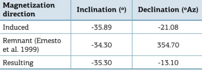
The remnant magnetization affects the interpretation of magnetic anomalies and generates misinterpretation con-cerning targets shape and size (e.g., Cordani & Shukowsky 2009). The South Atlantic Anomaly (Hartmann & Pacca 2009), characterized by low magnetic intensities in south-ern America, results in a natural remnant magnetization more important than the induced one. Thus, the theoretical response may be not compatible with the observed anom-aly. The available paleomagnetic data (Ernesto et al. 1999) was used to correct, through conventional vectorial sum, the inclination and declination directions of the total mag-netization. The reference values used, as well as the result-ing total magnetization vector, are summarized in Table 1. 2-D forward magnetic modeling was conducted from total anomaly profiles, exported from Geosoft, using the GRAVMAG software (Pedley et al. 1997). This software allows construct polygons with different forms and mag-netic susceptibilities using measured data profiles to create a theoretical anomaly, which could be successively refined to a best possible solution. In this sense, a previous good geological framework is necessary to build any magnetic coherent models (Pedley et al. 1997).
RESULTS AND DISCUSSION
The geologic suggested model
The Cavinatto quarry present the best exposition of the Limeira Intrusion, currently exposing a vertical section with
ca. 110 m deep in its southern and ca. 90 m in the northern sides. The intrusion has a sub-horizontal roof, which becomes stepped towards the NW area. The exposed basic-intermediate rocks show a great diversity of structures, textures, and modal compositions. The most typical types may be grouped in apha-nitic basalts, diabases, monzodiorites and quartz-monzodio-rites. Petrographic and geochemical details of the main rock types, as well as chemical compositions of the rock-forming minerals details, can be found in Faria (2008) and Lino (2015). A brief general characterization is presented in the following.
The aphanitic varieties (1.0–1.3 m thick) probably accom-pany all intrusion contours. They are made of massive thin chilled margins in contact with thermally metamorphosed sedimentary rocks, and aphanitic basic rocks, which may show some hydrothermal alteration due to interaction with the H2O-bearing host rocks. As granulation increases progres-sively inwards, the rock became a diabase, with a phaneritic texture and structures that changes from amygdaloidal to mas-sive inwards. The later crops out from ca. 1.3 to 20 m deep.
Clinopyroxene monzodiorites occur from ca. 20 to 60 m deep; their contacts with the overlaying diabases are usually sharp. They are very heterogeneous coarse-grained rocks, sometimes with a “jaguar-skin” aspect given by the irregu-lar distribution of the mafic and felsic minerals. Felsic pods do contain typical granophyric intergrowths. Granulation increases downwards while the mafic content decreases.
Clinopyroxene quartz-monzodiorites occur from ca. 60 to 90 m deep; they are heterogeneous to very coarse-grained rocks with cm-sized thin prismatic crystal of pyrox-ene, and well developed — sometimes platy — magnetite crystals, which imprints a grid-like texture over a similar “jaguar-skin” aspect. Their contacts with the monzodiorites appear to be gradational.
To the deepest levels exposed within the quarry, rock granulation decreases and compositions become again mon-zodioritic. These rocks are the ones characterized by rhyth-mic relatively mafic- and felsic-rich layers with sub-horizon-tal dips. Importantly, they occur only on the eastern and southern quarry walls.
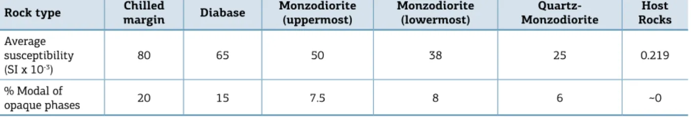
The average SM values obtained for these rocks are presented in Table 2. The basic-intermediate rocks pres-ent an average value about 44.5 × 10⁻³ (SI), while the
sed-imentary host rocks show, as expected, a much lower one, about 0.219 × 10⁻³ (SI). Among the formers, the aphanitic
basalts, the monzodiorites, and the quartz-monzodiorites Magnetization
direction Inclination (º) Declination (ºAz)
Induced -35.89 -21.08
Remnant (Ernesto
et al. 1999) -34.30 354.70
Resulting -35.30 -13.10
Rock type Chilled
margin Diabase
Monzodiorite (uppermost)
Monzodiorite (lowermost)
Quartz-Monzodiorite
Host Rocks
Average susceptibility (SI x 10-3)
80 65 50 38 25 0.219
% Modal of
opaque phases 20 15 7.5 8 6 ~0
Table 2. Magnetic susceptibility (×10-3 SI) and average modal composition of opaque phases (mainly Ti-magnetite/
magnetite and ilmenite) within the measured samples for the main rock types exposed in the Limeira Intrusion.
Figure 4. Schematic (N110E) geological cross section through Limeira Intrusion, showing the distribution of the
main rock-types, and the localization of the quarries. The figure illustrates the geometry of the intrusion based on interpretation of field observations.
present also very contrasted averages values (from 80 to ~45 and 25 × 10-3 SI, respectively), in accordance with their
Ti-magnetite/magnetite modal contents.
The following field observations suggest a lopolith- rather than sill- or laccolith-like intrusion geometry as presented in Figure 4 (see also Lino 2015):
■ part of northern contact with the enclosing siltstones is sub-vertical down to, as least 30–40 m deep, as revealed by prospecting drill holes in country rocks.;
■ structural emplacement evidences observed along the intrusion suggest it thins towards northwest, east and southeast;
■ the exposed layered sequences did not present the expected lateral distribution. They appear to constitute more or less concentric, localized, layers.
Geophysical analysis
Geophysical results are presented as magnetic anomaly maps for ground and aerial surveys, and the final 2D for-ward modeling, as follows.
Magnetic anomaly maps
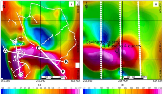
The total magnetic anomaly maps are presented in Figure 5. They show similar positive and negative anom-alies, as expected for targets located at this magnetic lati-tude — with predominant induced magnetization — pointing to a dipole over the Cavinatto and Basalto 4 quarries, which defines the probable horizontal occurrence of the intrusion. The main observed differences between the ground- and aeri-al-based maps are the dipole lay out, reflecting contrasted data acquisition systematics, and the anomalies intensities, which result from distinct vertical distances between the measurements and the target in each case.
Figure 5. Total anomalous magnetic field (nT) maps for the Limeira Intrusion based on our ground survey (i) and
the available aerial data (ii). The locations of the Cavinatto and Basalto 4 quarries, and the AB suggested geologic cross section (Fig. 4) are indicated. Note the dipolar anomaly centered over the quarries in both maps and the
difference range between the anomalous field intensities.
i ii
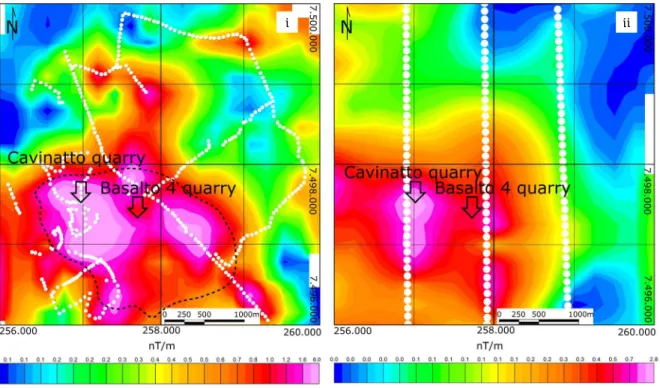
Figure 6. Analytical Signal Amplitude (ASA, nT/m) maps for the Limeira Intrusion, based on MAF data of ground survey (i) and the available aerial data (ii). Note that the ground data highlights two main regions with high ASA values, while aerial data (more defocused) presents an additional high ASA to southern, related to the raw data acquisition contrasted features (white dots). The black dotted line in (i) is our best estimated intrusion limits, based on both maps.
values twice as high as the aerial data due to the target prox-imity; on the other hand, the aerial data is cleaner from pos-sible anthropic interferences. Their combination allows to suggest the intrusion limits quite well on the basis of the maximum signal, as depicted in Figure 6.
The RTP obtained maps (Fig. 7) depict anomaly geo-metric features and their peek distributions, which are again similar in the ground- and aerial-based maps. In fact, they give the same response: two main high anomalies, aligned with the Cavinatto and Basalto 4 quarries tie line, and a rel-ative low anomaly between them. These lower values reflect, most probably, the lack of data over the area in both surveys.
In both cases, the positive anomaly is restricted to the most probable intrusion location. High anomaly variation gradients are observed close to the northern intrusion limits while relatively low gradients appear towards the southern limits. At first principles, the former suggest a high dipping contact while the later suggests a gradual lateral variation of the intrusion thickness.
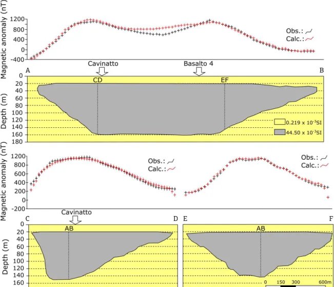
Magnetometric forward modeling
The RTP values derived from ground survey were used to estimate the 2D intrusion geometry along the three main profiles shown in Figure 7. For simplicity and easiness of data treatment, this model considers an average value for
the magnetic susceptibility [44.5 (10-3 SI)], which appears
to not affect substantially the overall model. The AB profile runs along the unique geological section available, while the CD and EF profiles run along the regions with most ground magnetometric measurements.
The presented geophysical model considers that the top depth approaches 20 m thickness, as estimated from measure-ments in some locations next to Cavinatto quarry. Results are depicted in Figure 8, which presents, among the 2D theo-retical possible models, the total anomaly model that best fits with our geological data, along these profiles. In fact, as drawn in the Figure 8, calculated and observed total magnetic anomalies match very well; minor discrepancies, especially in central zone of the A-B profile, are probably related to the lack of ground measurement stations, leading to less accurate interpolation. The differences between the observed and cal-culated anomalies, at the beginning and ending of the CD and EF profiles, most probably, result from border effects.
CONCLUDING REMARKS
The integration of ground and aerial magnetic data, geo-logical information and magnetic susceptibility measure-ments in rocks allowed set out an improved interpretation
Figure 7. Reduced to Pole (RTP, in nT) maps for the Limeira Intrusion, based on MAF to ground survey (i) and available
aerial data (ii). Note the high anomaly over the quarries. The AB, CD and EF profiles correspond to total anomaly
sections, extracted for the two-dimensional modeling. White dots represent the localization of data acquisition.
on the lateral distribution and the 2D geometry of the Limeira Intrusion. Our results suggest that the intrusion has an elliptical shape, occupying a top area of about 2.5 to 3.0 km2, and its thickest zone corresponds to the quarries
north portions. The modeled two-dimensional magneto-metric profiles support a lopolithic-like intrusion geometry very well, as previously suggested from geologic evidences. The model has some intrinsic limitations however, and the main drawback come from field station distribution, which affects interpolation processes, as some relatively large areas were not sampled due to exposure problems in rela-tion to the locarela-tion of the AB profile. On the other hand, the removal of the sedimentary cover, allowing direct rock exposure, increases magnetic anomalies, while the removal of rocky material — as in the extreme case of the Cavinatto quarry — decreases the total volume of ferromagnetic minerals
and, thus, the magnetic signal intensity. These later effects cannot be properly quantified and corrected up to now, and may led to some misinterpretation.
The analysis of the two-dimensional profiles allows infer-ring some emplacement mechanisms for the Limeira Intrusion. The profiles AB and EF suggest that the intrusion evolved, most probably, trough progressively emplacement of fresh magmatic pulses in the central zone of the magmatic cham-ber, causing its growth by the mechanism of inner-accretion (e.g., Menand 2011). The north region coincides with the thicker zone of the intrusion, and supports the hypothesis that this may be the recharge area of the intrusion.
The geometry and volume of the Limeira Intrusion opened ways for the development of several specific mag-matic (e.g., magmag-matic recharge and differentiation) and post-magmatic (e.g., hydrothermal alteration) processes,
Figure 8. Schematic two-dimensional magnetic model of Limeira Intrusion, based on the presumed geologic
model, total magnetic anomalies (at AB, CD and EF profiles) and magnetic average susceptibility measurements.
See text for discussion.
A
C E
B
turning it an interesting target for detailed petrological and metalogenetic studies.
ACKNOWLEDGEMENTS
We thank FAPESP Thematic Project 2012/06082-6 (Coord. Dr. E. Ruberti) for financial support. LML thanks
CAPES for a MSc. Schollarship. Previous discussions with Y. Maragoni and M. Ernesto help to improve our geophys-ical analysis. We are grateful to the Companhia de Pesquisa de Recursos Minerais (CPRM, Geological Survey of Brazil), which allowed the use and publication of airborne geo-physical data in the region of Limeira Intrusion, and grate-ful to BJG editors and anonymous reviewers, who help to improve the paper.
Baronov W. 1957. A new method for Interpretation of aeromagnetic Maps: Pseudo-Gravimetric Anomalies. Geophysics, 22:359-382. https://doi.org/10.1190/1.1438369
Bellieni G., Comin-Chiaramonti P., Marques L.S., Melfi A.J., Piccirillo E.M., Nardy A.J.R., Roisenberg A. 1984. High-and low-TiO2 flood
basalts from the Paraná plateau (Brazil): petrology and geochemical aspects bearing on their mantle origin. Neues Jahrbuch für Mineralogie Abhandlungen, 150:273-306.
Briggs I.C. 1974. Machine contouring using minimum curvature. Geophysics, 39:39-48. https://doi.org/10.1190/1.1440410
Brückmann M., Hartmann L.A., Tassinari C.C.G., Sato K., Baggio S.B. 2014. A duração do magmatismo no Grupo Serra Geral, província vulcânica Paraná. In: Hartmann L.A., Baggio S.B. (eds.), Metallogeny and mineral exploration in the Serra Geral Group. Rio Grande do Sul, UFRGS Academic Press. v. 1, p. 233-243.
Bryan S.E. & Ernst R.E. 2008. Revised definition of large igneous
provinces (LIPs). Earth-Science Reviews, 86:175-202. https://doi. org/10.1016/j.earscirev.2007.08.008
Cavallaro F.A. 2013. Investigação geofísica do alto estrutural de Anhembi – SP. PhD Thesis, Institute of Geoscience, University of São Paulo, São Paulo, 148 p. Available from: <http://www.teses.usp. br/teses/disponiveis/44/44137/tde-11022014-145456/pt-br.php>. Accessed on: April 20, 2017.
Comin-Chiaramonti P., Bellieni G., Piccrillo E.M., Melfi A.J. 1988. Classification and petrography of continental stratoid volcanics and
related intrusives from the Paraná basin (Brazil). In: Piccrillo E.M., Melfi
A.J. (eds.), Mesozoic Flood Volcanism from the Paraná basin (Brazil): Petrogenic and Geophisical Aspects. São Paulo, IAG-USP. p. 47-72.
Cordani R. & Shukowsky W. 2009. Magnetização Remanescente: um parâmetro crucial para a interpretação e modelamento de anomalias magnéticas em território brasileiro. Revista Brasileira de Geofísica, 27:659-667. http://dx.doi.org/10.1590/ S0102-261X2009000400009
Cruden A.R. 1998. On the emplacement of tabular granites. Journal of the Geological Society-London, 155(5):853-862. https://doi. org/10.1144/gsjgs.155.5.0853
Ernesto M. & Pacca I.G. 1988. Paleomagnetism of the Paraná Basin Flood volcancs, Southern Brasil. In: Piccirillo E.M. & Melfi A.J. (eds.),
The Mesozoic Flood Volcanism of the Paraná Basin: Petrogenetic and Geophys. Aspects. São Paulo, IAG-USP, p. 229-255.
Ernesto M., Raposo M.I.B., Marques L.S., Renne P.R., Diogo L.A., De Min A. 1999. Paleomagnetism, geochemistry and 40Ar/39Ar dating of the North-eastern Paraná magmatic province: tectonic implications. Journal of Geodynamics, 28:321-340. DOI: 10.1016/S0264-3707(99)00013-7
Faria C.A. 2008. Geoquímica, Petrografia e Evolução Magmática do
Sill de Limeira. Dissertation, Institute of Geoscience, University of
REFERENCES
São Paulo, São Paulo, 106 p. Available from: <http://www.teses.usp. br/teses/disponiveis/44/44143/tde-04122008-152040/en.php>. Accessed on: April 1, 2017.
Ferreira F.J., de Souza J., Bongiolo A.B.S., de Castro L.G. 2013. Enhancement of the total horizontal gradient of magnetic anomalies using the tilt angle. Geophysics, 78(3):J33-J41. https://doi. org/10.1190/geo2011-0441.1
Frank H.T., Gomes M.E.B., Formoso M.L.L. 2009. Review of the areal extent and the volume of Serra Geral Formation, Paraná Basin, South America. Pesquisas em Geociências, 36:49-57.
Franke W. 1992. Phanerozoic structures and events in Central Europe. In: Blundell D., Freeman R., Mueller S. (eds.), A continent revealed: the European Geotraverse. Cambridge, Cambridge University Press, p. 164-179.
Gallagher K. & Hawkesworth C. 1994. Mantle plumes, continental magmatism and asymmetry in the South Atlantic. Earth and Planetary Science Letters, 123:105-117. https://doi. org/10.1016/0012-821X(94)90261-5
Hartmann G.A. & Pacca I.G. 2009. Time evolution of the South Atlantic Magnetic Anomaly. Anais da Academia Brasileira de Ciências,
81:243-255. http://dx.doi.org/10.1590/S0001-37652009000200010
Hartmann L.A. 2014. Introdução à histótria natural do Grupo Serra Geral. In: Hartmann L.A. & Baggio S.B. (eds.), Metallogeny and mineral exploration in the Serra Geral Group. Rio Grande do Sul, UFRGS Academic Press. v. 1, p. 17-20.
Hawkesworth C.J., Gallagher K., Kelley S., Mantovani M., Peate D.W., Regelous M., Rogers N.W. 1992. Paraná magmatism and the opening of the South Atlantic. In: Storey B., Alabaster A., Pankhurst R. (eds.), Magmatism and the Causes of Continental Break-up. Geological Society, London, Special Publications, 68:221-240.
Kearey P. & Brooks M. 2002. An introduction to Geophysical exploration. Boston, Blackwell Science Publisher. 296 p.
Li X. 2006. Understanding 3D analytic signal amplitude. Geophysics,
71(2):L13-L16. https://doi.org/10.1190/1.2184367
Lino L.M. 2015. A intrusão toleítica de Limeira (SP) contribuição à
geologia e estratigrafia de uma intrusão acamadada. Monograph,
Institute of Geoscience, University of São Paulo, São Paulo, 60 p. Available from: <http://sbg.sitepessoal.com/anais48cbg/st12/ ID5715_110844_52_A_INTRUSAO_TOLEITICA_DE_LIMEIRA.pdf>. Accessed on: April 12 2017.
Marques L.S. & Ernesto M. 2004. O magmatismo toleítico da Bacia do Paraná. In: Manteso-Neto V., Bartorelli A., Carneiro C.D.R., Brito-Neves B.B. (eds.), Geologia do Continente Sul-Americano: Evolução e Obra de Fernando Marques de Almeida. São Paulo, Beca, p. 245-263.
Menand T. 2011. Physical controls and depth of emplacement of igneous bodies: a review. Tectonophysics, 500(1):11-19. https://doi. org/10.1016/j.tecto.2009.10.016
Milani E.J. 2004. Comentários sobre a origem e evolução tectônica da Bacia do Paraná. In: Mantesso-Neto V., BartorellI A., Carneiro C.D.R. (eds.), Geologia do Continente Sul-Americano: a Evolução da Obra de Fernando Flávio Marques de Almeida. São Paulo, Beca, p. 265-291.
Milsom J. 2003. Field Geophisics. London, Jonh Wiley & Sons Ltd., 229 p.
Nabighian M.N. 1972. The analytic signal of two dimensional magnetic bodies with polygonal crossection: Its properties and use for automated anomaly interpretation. Geophysics, 37:507-517. https://doi.org/10.1190/1.1440276
Nabighian M.N. 1984. Toward a three-dimensional automatic
interpretation of potential field data via generalized Hilbert
transforms: Fundamental relations. Geophysics, 49:780-786. https:// doi.org/10.1190/1.1441706
Nardy A.J.R., Oliveira M., Betancourt R., Verdugo D., Machado F.B. 2003.
Litoestratigrafia da Formação Serra Geral. Geociências, 21:15-32.
Nardy A.J.R., Oliveira M.A.F., Betancourt R.H.S., Verdugo D.R.H.,
Machado F.B. 2002. Geologia e estratigrafia da Formação Serra Geral.
Revista de Geociências UNESP, 21:15-32.
Oliveira E.P. & Dantas E. 2008. Closed System differentiation in
Mesozoic High-Ti Basic Sill of Limeira, São Paulo State: Implications
for the origin of bimodal felsic-mafic volcanic rocks in the Paraná
Igneous Province. In: Simpósio de Vulcanismo e Ambientes Associados, 4., Foz do Iguaçu, SBG. Anais... SBG, Foz do Iguaçu.
Peate D.W. 1997. The Paraná-Etendeka Province. In: Mahoney J.J. &
Coffin M.F. (eds.), Large igneous provinces: Continental, oceanic, and planetary flood volcanism. Geophysical Monograph, Washington, D.C., p. 217-245.
Peate D.W. & Hawkesworth C.J. 1996. Lithospheric to
asthenospheric transition in Low-Ti flood basalts from southern
Paraná, Brazil. Chemical Geology, 127:1-24. https://doi. org/10.1016/0009-2541(95)00086-0
Peate D.W., Hawkesworth C.J., Mantovani M.S.M. 1992. Chemical
stratigraphy of the Paraná lavas (South America): classification of
magma types and their spatial distribution. Bulletin of Volcanology,
55:119-139. DOI: 10.1007/BF00301125
Peate D.W., Hawkesworth C.J., Mantovani M.M., Rogers N.W., Turner S.P. 1999. Petrogenesis and stratigraphy of the high-Ti/Y Urubici
magma type in the Paraná flood basalt province and implications
for the nature of ‘Dupal’-type mantle in the South Atlantic region. Journal of Petrology, 40(3):451-473. https://doi.org/10.1093/ petroj/40.3.451
Peate D.W., Hawkesworth C.J., Mantovani M.S.M., Shukowsky
W. 1990. Mantle Plumesand flood basalts stratigraphy in the
Paraná, South America. Geology, 18:1223-1226. https://doi. org/10.1130/0091-7613(1990)018%3C1223:MPAFBS%3E2.3.CO;2
Pedley R.C., Busby J.P., Dabek Z.K. 1997. GRAVMAG User manual: interactive 2.5D gravity and magnetic modeling. British Geological Survey, Technical Report, 73 p.
Perrota M.M. & Salvador E.D. 2005. Mapa geológico do Estado de
São Paulo – Integração na escala 1:750.000. São Paulo, Programa de
Levantamentos Geológicos do Brasil, CPRM.
Philips J.D. 2007. Geosoft eXecutables (GX’s) developed by the U.S.
Geological Survey, Version 2.0, with notes on GX development from FORTRAN code (Open-File Report 2007-1355), 111 p.
Piccirilo E.M. & Melfi A.J. (eds.). 1988. Mesozoic flood volcanism of
the parana basin: Petrogenetic and Geophisical aspects. São Paulo, IAG-USP, 600 p.
Rudnick R.L. & Fountain D.M. 1995. Nature and composition of the continental crust: a lower crustal perspective. Reviews of Geophysics,
33(3):267-309.DOI: 10.1029/95RG01302
Seixas A.R., Nardy A.J.R., Moreira C.A., Pereira A.M. 2015. Caracterização magnetométrica do Sill de Limeira-SP. Geociências,
34:169-184.
Soares P.C. 1985. Informações sobre Sills de diabásio da Bacia do Paraná. Curitiba, DOCEGEO.
Telford W.M., Geldart L.P., Sheriff R.E., Keys D.A. 1976. Applied Geophysics. Cambridge, Cambridge University Press, 860p.
Turner S.P. & Hawkesworth C.J. 1995. The nature of the sub-continental mantle: constraints from the major element composition
of continental flood basalts. Chemical Geology, 120:295-314. https:// doi.org/10.1016/0009-2541(94)00143-V
Zalán P.V., Conceição J.D.J., Wolff S., Astolfi M.A.M., Vieira I.S., Neto
E.V.S., Marques A. 1986. Análise da bacia do Paraná. Relatório Interno Gt-Os-009/85 (Depex-Cenpes), Rio de Janeiro, Petrobras, 195 p.