Abrigo de la Quebrada Level IV (Valencia, Spain):
Interpreting a Middle Palaeolithic Palimpsest
from a Zooarchaeological and Lithic Perspective
Cristina Real
1,2,3 &Aleix Eixea
2,4,5&Alfred Sanchis
3&Juan Vicente Morales
1,2&Nicole Klasen
6&João Zilhão
1,2,7,8&Valentín Villaverde
1,2# Springer Nature Switzerland AG 2018
Abstract
The Abrigo de la Quebrada (Chelva, Valencia) stratigraphic succession comprises nine
Middle Palaeolithic levels. Human selection of this rock shelter for occupation owes to
its favourable location
—at the gates of a blind valley where the trapping of large
herbivores would have been practicable. The immediate environment is varied, with
both abrupt and flat terrain, and would have supported a wide range of prey animals.
Radiocarbon-dated charcoal samples from level IV, which is characterised by a high
density of lithic (> 18,000) and bone (> 100,000) remains, yielded results of 43,930 ±
750 BP (Beta-244002) and > 51,6 ka BP (OxA-24855). There is no evidence of
modification by carnivores or birds of prey, so this level’s faunal remains must be
anthropogenic in the main. Relative to the inhabited space, the location of level IV’s
many combustion features shows little variation. The level’s typical palimpsest
struc-ture results from frequent, repeated occupations with intense on-site processing in a
context of low sedimentation rates. The study of seasonality, carcass exploitation,
taphonomy, stone tool refitting and raw material provenience patterns supports the
notion that the different occupations subsumed in the level IV deposit were all short
term. The comparison of our results with coeval contexts from the central area of
Mediterranean Iberia sheds additional light on the adaptations of western Europe
’s
Neanderthal groups.
Keywords
Palimpsest . Neanderthal subsistence . Middle Palaeolithic . Iberian Peninsula
Journal of Paleolithic Archaeologyhttps://doi.org/10.1007/s41982-018-0012-z
Electronic supplementary material The online version of this article ( https://doi.org/10.1007/s41982-018-0012-z) contains supplementary material, which is available to authorized users.
* Cristina Real [email protected]
Introduction
The spatial patterning of Eurasian Middle Palaeolithic, Neanderthal-associated
settle-ment sites has been intensely debated (Conard
2001
,
2004
; Moncel
2003
; Delagnes and
Rendu
2011
; Daujeard et al.
2012
). This is because, to a large extent, spatial patterns are
one of the key elements in the reconstruction of social and economic behaviours
(Rolland
1990
; Mellars
1996
; d’Errico et al.
1998
; Gamble
1998
; Vaquero et al.
2001
; Burke
2006
). The interpretation problems derive from the fact that, in most
cases, our unit of analysis (the
‘archaeological level’) is the result of different
occupa-tion events forming what Bailey (
2007
) has defined as cumulative palimpsests. This
raises the need to dissect the palimpsests into the individual occupational events they
subsume, or, if possible, into the minimum constituent units of each such event.
To this aim, several approaches have been used—among others: geoarchaeological
and archaeo-stratigraphical (Brochier
1999
; Canals
1993
; Goldberg and Macphail
2006
; Mallol et al.
2010
; Vallverdú-Poch and Courty
2012
); ethnographic comparison
(Binford
1978
; O’Connell,
1987
; O’Connell et al.
1992
; Yellen
1977
); statistical and
mathematical modelling (Carr
1987
; Kintigh and Ammerman
1982
; Simek
1987
;
Stapert
1990
; Whallon
1984
); bone and stone tool refitting (Cziesla
1990
; Cziesla et
al.
1990
; Eixea et al.
2011–2012
; Gabucio et al.
2017
; Machado et al.
2013
; Rosell
et al.
2012a
; Villa
1982
; Vaquero
1999
); analyses of artefact density and of the
frequency of retouched pieces relative to total lithic assemblage size (Barton and
Riel-Salvatore
2014
; Clark and Barton
2017
); technological analysis of raw material
units (RMUs) (Conard and Adler
1997
; Adler et al.
2003
; Turq et al.
2017
; Roebroeks
1988
); studies of combustion features (Courty et al.
2012
; Henry
2012
; Mallol et al.
2013
; Vaquero and Pastó
2001
); or analyses of the dispersion of archaeobotanical
remains (seeds, fruits and charcoals) (Castro-Curel and Carbonell
1995
; Chabal
1988
;
Solé et al.
2013
; Thiébault
1995
; Vidal-Matutano
2016
; Vidal-Matutano et al.
2017
).
The complementary nature of these methods and techniques allows the synchronisation
of activities, upon which occupation events can in turn be individualised, making it
possible to arrive at better estimates of group size and occupation length and, hence, at
a better understanding of socio-economic strategies.
In the present study, we analyse the lithic and bone data from level IV of Abrigo de
la Quebrada, which is a clear example of a cumulative palimpsest (Eixea
2015
; Eixea
et al.
2011–2012
; Villaverde et al.
2008
,
2017
). The complexity of the accumulation
does not allow the subdivision of the finds into discrete sets related to a corresponding
unique event. Thus, we consider the deposit’s content as whole and look at its spatial
structure under a technological and taphonomical perspective to try to better understand
the general nature of the different human occupations therein subsumed.
Materials and Methods
The Site
The Middle Palaeolithic rock shelter of Abrigo de la Quebrada (Chelva, Valencia,
Spain) lies in an area demarcated by the Tuéjar-Chelva and Turia rivers, between steep
mountain formations: the Macizo de Javalambre (part of the Sistema Ibérico) and the
Serra d’Utiel. The site, situated on the left side of the Rambla de Ahillas canyon,
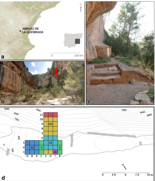
corresponds to a sheltered area that, today, is 38 m long and 2–9 m wide (Fig.
1
).
Originally, the shelter’s surface would have been larger, reaching a maximum
ampli-tude of 11 m. Slope erosion processes explain the truncation of the deposit, whose
upper reaches, including level IV, were most affected. The site was excavated between
2007 and 2015, over an area of 30 m
2for the upper levels and of 27 m
2for the lower
ones.
The Quebrada stratigraphic succession spans approximately 4 m and comprises nine
units (Table
1
). Level I, at the top, is disturbed by penning. Middle Palaeolithic human
occupations are recorded in levels II to V and VII to IX; level VI is archaeologically
Fig. 1 Abrigo de la Quebrada: location (a, b); site overview (c); excavation trench (the Roman numerals indicate the level reached in each square) (d)
sterile. Anthropogenic inputs are especially significant in levels III, IV and V. In the
present study, we focus on level IV, dated to the early stages of MIS 3 (see below).
Charcoal analysis of uppermost levels I–IV shows a dominance of Pinus (Pinus nigra
and Pinus sylvestris), Juniperus and other gymnosperms. Quercus, Rhamnus and other
dicotyledonous plants were also identified but in low numbers (Badal et al.
2012
). These
results indicate dry or sub-humid supramediterranean conditions through the entire
se-quence, with no indication of warm episodes (Badal et al.
2012
). This inference is consistent
with the phytolith data (Esteban et al.
2015
). The few micro-mammalian remains found in
the upper levels of MIS 3 age (Table
1
) most likely reflect accumulation by small carnivores
at times when the site was not occupied by humans (Tormo and Guillem-Calatayud
2015
)
and their species composition is consistent with the palaeobotanical data.
Methods
Lithic and Refits Analysis
To establish the technological characteristics of each rock (flint, quartzite, limestone
and quartz) and their relation to procurement, stone tools were organised into raw
material units (RMU) (Conard and Adler
1997
; Roebroeks
1988
; Vaquero
2008
) whose
separateness was verified by macro- and microscopic analysis (Eixea et al.
2011
,
2014
;
Prudêncio et al.
2016
; Roldán et al.
2015
). The technological study was conducted from
a chaîne opératoire perspective (Boëda et al.
1990
; Bourguignon et al.
2004
; Faivre
2011
; Geneste
1985
,
1988
; Tixier et al.
1980
; Turq
2000
), and retouched pieces
(including those with macro- and micro-use wear) were classified using the type list
of Bordes (
1988
). The different sequences of the operational chains and the temporality
relations of the sample were assessed through refitting. All the finds taken in
consid-eration for the establishment of different kinds of knapping activities
—exploitation,
Table 1 Abrigo de la Quebrada. Summary of available archaeological data. The age data consist of radiocarbon dates on charcoal for levels III, IV and V and of luminescence age estimates for level VI. For details of the luminescence dating work, see Suppl. Table1Level Thickness (cm)
Excavated area (m2)
Chronology MIS Environment F a u n a (NR) Lithics (NR) II 10–15 24 – 4-3 Sub-humid supramediterrane-an conditions 37,426 3046 III 10–20 30 40,500 ± 530 (Beta-244003)/>-50,800 (OxA-24,854) 4-3 72,191 8498 IV 20–25 30 43,930 ± 750 (Beta-244002)/>-51,600 (OxA-24855) 4-3 10,0909 18,936 V 25–30 21 > 47,100 (OxA-25583) 4-3 78,001 15,580 VI 65–70 23 79 ± 5/82 ± 5 (C-L3898, C-L3900) 5a – –
VII 40–45 23 – 5 Study in process 6997 92
VIII 45–50 23 – 5 20,365 522
configuration, retouching, fracturing—and the distances between the elements were
quantified, as was their location in space (Cziesla
1990
; Cziesla et al.
1990
; Kvamme
1997
; Newcomer and Sieveking
1980
; Vaquero et al.
2017
).
Archaeostratigraphy and Spatial Analysis
ArcGIS® software was used to assess the existence of breaks in the horizontal and
vertical distribution of the remains, potentially indicative of occupational hiatuses that
could be used to subdivide the palimpsest into its different components (Canals
1993
;
Canals et al.
2003
; Vaquero et al.
2012a
,
b
). For level IV, the finds were projected on 5
–
10-cm-thick vertical slices cut across the central area of the excavation trench, which
were found to be representative of both the internal and external parts of the inhabited
space, preserved in bands 3 to 5 of the excavation grid (Eixea
2015
; Eixea et al.
2011–
2012
; Villaverde et al.
2017
).
Faunal Remains
Level IV comprises four excavation spits (6, 7, 8 and 9) (Eixea et al.
2011–2012
,
2012
;
Sanchis et al.
2013
; Villaverde et al.
2017
). The faunal content of these spits was
analysed in its entirety. Taxonomic and anatomical identifications were made against
the reference collection of the Gabinet de Fauna Quaternària (Museu de Prehistòria de
València). The indeterminate fragments for which only an anatomical identification was
possible were classified into three groups according to their size: large, medium and
small.
The number of remains (NR), the number of identified specimens (NISP) and the
minimum number of individuals (MNI) (Lyman
1994
,
2008
) were calculated. The
correlation between the survival index (%ISu) (Brain
1981
; Lyman
1994
) and the bone
density of the best represented taxa (Hillson
1992
; Lyman
1985
) was assessed via
calculation of Pearson’s r. Age-at-death was established based on dental eruption and
wear and epiphysis fusion (Azorit et al.
2002
; Hillson
1986
; Mariezkurrena
1983
; Pérez
Ripoll
1988
; Serrano et al.
2004
; Silver
1980
).
Classification of fractures followed Villa and Mahieu (
1991
). A binocular loupe
(Nikon SMZ-10A) was used for the study of surface modifications. Cut mark
classi-fication followed the relevant literature (Binford
1981
; Bromage and Boyde
1984
;
Noe-Nygaard
1989
; Potts and Shipman
1981
; Shipman and Rose
1983
). Burnt remains were
recorded for colour and localisation of the burning after Nicholson (
1993
), Stiner et al.
(
1995
) and Théry-Parisot et al. (
2004
). The assessment of post-depositional
modifica-tions followed Lyman (
1994
).
Luminescence Dating
Two samples were collected from archaeologically sterile unit VI at depths of 1.8 m
(C-L3898) and 1.4 m (C-L3900) to provide a terminus post quem for the formation of unit
IV. The sediment is laminated, which indicates fluvial deposition. Sample preparation
and equipment are the same as described in Klasen et al. (
2018
). We used a
single-aliquot regenerative-dose approach (SAR) for all measurements (Murray and Wintle
2000
,
2003
). Laboratory experiments included a preheat plateau test and a dose
Journal of Paleolithic Archaeologyrecovery test. Multiple grain feldspar aliquots (1 mm) were measured using
post-infrared post-infrared stimulation (pIRIR, Thomsen et al.
2008
; Thiel et al.
2011
), and we
obtained the most appropriate stimulation temperature using a range of different
temperatures as well as a dose recovery test. The radionuclide concentration of the
surrounding sediments was measured using high-resolution gamma-ray spectrometry.
The dose rate was calculated using the conversion factors of Guerin et al. (
2011
), an
assumed water content of 10 ± 3%, an a value of 0.07 ± 0.02 as well as an assumed
potassium content of 12.5 ± 0.5% (Huntley and Baril
1997
). The rubidium
concentra-tion was calculated from the potassium concentraconcentra-tion (Mejdahl
1987
), and the cosmic
dose rate was calculated after Prescott and Hutton (
1994
).
Results
Site Chronology
Radiocarbon accelerator mass spectrometry (AMS) dating of ABA-treated charcoal
fragments yielded ages of 40,500 ± 530 BP 244003) and 43,930 ± 750 BP
(Beta-244002) for levels III and IV, respectively (Villaverde et al.
2008
). The levels III and IV
are also dated by an ABOx-processed sample, which yielded a result of > 50,800
(OxA-24854) and > 51,600 BP (OxA-24855) (Eixea et al.
2011–2012
). We present also
an unpublished date from level V (Quebrada 2010 G3C11 Sc5), made by an
ABOx-processed sample on charcoal fragment (Pinus nigra/sylvestris): > 47,100
(OxA-25583).
The preheat plateau exposed that the quartz OSL signal was saturated, and therefore,
quartz was not further measured. According to the laboratory experiments, the most
appropriate temperature combination to measure the feldspar samples is pIR
80IR
290stimulation (Suppl. Fig.
1
). The feldspar age estimates (Suppl Tab.
1
) of 80.0 ±
4.7 ka (C-L3900) and 83.2 ± 5.4 ka (C-L3898) for level VI, which is archaeologically
sterile, provide a maximum age for the Middle Palaeolithic occupations in overlying
levels II–V. These results indicate deposition during MIS 3–4 for levels II–V, during
MIS 5a for level VI, and, potentially, deposition during earlier phases of MIS 5 for
levels VII–VIII, which remain undated but yielded a small mammal assemblage
consistent with an Upper Pleistocene chronology (Tormo and Guillem-Calatayud
2015
).
The Level IV Lithic Industry
Blanks and Raw Materials
Level IV yielded 18,936 lithic remains. Chips, < 1 cm in length, are the most abundant
blanks (87.6%), indicating the high intensity of reduction. Production mostly focused
on the extraction of quadrangular flakes, 2–4 cm long and wide and 0.5–1 cm thick
(Eixea
2015
; Villaverde et al.
2017
) (Table
2
). Four different rocks have been identified
so far: flint, limestone, quartzite and quartz. The local, Domeño-type flint is the most
abundant raw material. It occurs in Middle Jurassic formations and is well suited for
knapping. The geological stratum where it was first identified outcrops in the hillsides
above River Turia, 5–8 km from the site. The allochthonous flints, classified into four
subgroups (types 1, 2, 3 and 4), are good-quality raw materials whose macroscopic
attributes differ from the Domeño type and match sources located > 100 km away
(Eixea et al.
2011
; Prudêncio et al.
2016
; Roldán et al.
2015
). The quartzite and
limestone blocks selected for knapping are fine-grained and have a microcrystalline
structure. They were likely collected as cobbles in the Ahillas streambed, a few meters
away.
Knapping Systems and Tools
Lithics were produced using discoid and recurrent-centripetal Levallois methods.
Dorsal scars are mostly centripetal in both knapping systems; a few scars indicate
unidirectional and bidirectional reduction sequences. The abundance of cortex-bearing
cores and flakes of different sizes indicates that knapping was carried out on site. Flake
sizes are small to medium; a significant number—both retouched and unretouched—
are smaller than 1.5 cm (Eixea
2015
; Villaverde et al.
2008
,
2017
). Retouched pieces
are slightly larger than average.
Table 2 Abrigo de la Quebrada. Stone tool data for level IV. For additional detail, see Eixea (2015), Eixea et al. (2015,2016) and Villaverde et al. (2012,2017)
N %
Raw materials Flint 1218 61.39
Quartzite 419 21.12
Limestone 345 17.39
Quartz 2 0.10
Knapping methods Discoid 663 35.47
Levallois 519 27.77 Kombewa 29 1.55 Laminar 2 0.11 Indeterminate 656 35.10 Blanks Flakes 1805 77.43 Laminar flakes 49 2.10
Blades and small blades 15 0.64
Cores 54 2.32 Thermoclast 390 16.73 Shapeless 8 0.34 Cobbles 10 0.43 Tools Points 35 7.32 Sidescrapers 247 51.67
Notches and denticulates 35 7.32 Upper Palaeolithic group 5 1.05 Pieces with use-wear 54 11.30
Other 102 21.34
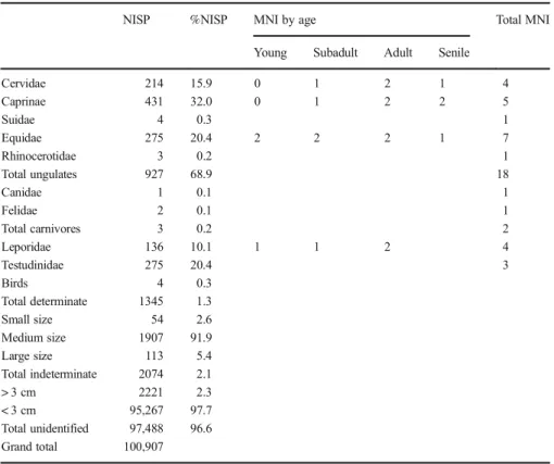
Table 3 Abrigo de la Quebrada. Faunal data for level IV
NISP %NISP MNI by age Total MNI
Young Subadult Adult Senile
Cervidae 214 15.9 0 1 2 1 4 Caprinae 431 32.0 0 1 2 2 5 Suidae 4 0.3 1 Equidae 275 20.4 2 2 2 1 7 Rhinocerotidae 3 0.2 1 Total ungulates 927 68.9 18 Canidae 1 0.1 1 Felidae 2 0.1 1 Total carnivores 3 0.2 2 Leporidae 136 10.1 1 1 2 4 Testudinidae 275 20.4 3 Birds 4 0.3 Total determinate 1345 1.3 Small size 54 2.6 Medium size 1907 91.9 Large size 113 5.4 Total indeterminate 2074 2.1 > 3 cm 2221 2.3 < 3 cm 95,267 97.7 Total unidentified 97,488 96.6 Grand total 100,907
Fig. 2 Body-part representation (%NISP) of the main families identified in the faunal assemblage from level IV of Quebrada. Antler (Ant), cranium (Cr), maxillary (Mx), mandible (Mand), teeth (Th), rib (Rb), scapula (Sc), humerus (H), radius (R), ulna (U), carpal (Cp), metacarpal (Mc), coxal (Cx), femur (F), tibia (T), metatarsal (Mt), patella (Pa), astragal (As), calcaneus (Ca), metapodia (Mtp), first phalange (Pha1), second phalange (Pha2), third phalange (Pha3), sesamoid (Se)
Retouched tools are 424, and another 54 pieces bear use-wear. Cortex is seen in
34.8% of the sample; lateral overshooting is seen in only four tools. Scrapers with
Fig. 3 Anthropogenic modification in faunal remains from level IV of Quebrada: green fractures (a); fragments detached by impact (b); percussion notches on remains of middle-size prey (c); cut marks on the remains of middle-size prey (d); Testudo hermanni plates, one with a cut mark (e)a single modified edge amount to 42.9% of the retouched tools, while those with
two or more modified edges are 8.8%. Sixty-two percent of the single scrapers are
convex and 20% are transversal-convex; their blanks are mostly Levallois, either
recurrent-centripetal or preferential. Cortex is more frequently present in scrapers,
often in lateral zones, than in other pieces, so scrapers tend to be naturally backed
(Eixea
2015
). The simple, continuous and direct types of retouch predominate,
often eliminating a sizable proportion of the blank
’s original edge (Table
2
).
There are 28 Mousterian points (5.8% of the formal tools). The primary blanks are
both Levallois (50%), mostly of the preferential variety, and discoid (40%); use of the
latter results in tools that are thicker and asymmetric (Eixea et al.
2015
). Notches and
denticulates (not very invasive and mostly laterally located) amount to 7.3% and are
made on both discoid (50%) and Levallois (30%) blanks. The number of Upper
Palaeolithic-like implements is low (1%): they are all backed knives, four typical and
one atypical. The Levallois typological group represents 23% of the formal tools; these
are mostly typical Levallois flakes (14.4%), atypical ones (7.7%) and points (1.5%)
(Eixea
2015
).
The Level IV Faunal Assemblage
Species Composition
The level IV sample totals 100,907 remains (Table
3
). Of these, 1.3% have been
identified taxonomically; the remainder correspond to fragments that could be
identi-fied anatomically and classiidenti-fied by size (2.1%), and to indeterminate fragments
(96.6%). The undetermined items are smaller than 3 cm in 97.7% of the cases, and
even though some are spongy bones, most (> 80%) are long bone fragments.
The assemblage features a taxonomic diverse range of medium- and large-size
ungulates, but carnivores and small game are also present. Eight different families have
been identified (Table
3
): Bovidae (Caprinae), Equidae, Cervidae, Leporidae,
Table 4 Abrigo de la Quebrada. Anthropogenic modification in the faunal remains from level IVNotches Cut marks Burnt
NR NR %NR Caprinae 16 3 44.3 Cervidae 9 34.1 Equidae 2 31.6 Leporidae 47.8 Testudinidae 3 74.2 Large size 6 1 34.5 Medium size 22 42 36.7 Small size 7 53.7 Indeterminate 10 37 Total 55 66
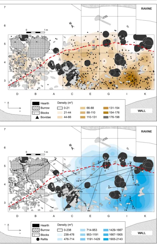
Fig. 4 Spatial patterning in level IV of Quebrada (the dashed red line indicates the position of the extant drip line): the remains of Caprinae against the iso-density plot of the totality of the bone assemblage (a); stone tool refit links against the iso-density plot of the totality of the lithic assemblage (b)
Testudinidae, Suidae, Rhinocerotidae, Felidae and Canidae (Sanchis et al.
2013
). There
are also some bird bones.
By NISP, Caprinae (32%), followed by Equidae (20.4%) and Cervidae (15.9%), are
the dominant taxa. Using MNI, Equidae are the more important, with seven individuals,
leaving behind Caprinae and Cervidae with five and four, respectively (Table
3
). As for
small game, there is a notable presence of tortoises (Testudo hermanni) (20.4%),
followed by leporids (10.1%). The eruption and wear of the teeth of Equidae, Caprinae
and Cervidae suggests that the shelter was occupied by humans between spring and
autumn. Further precision must await the results of forthcoming dental micro-wear
analyses (Rivals and Deniaux
2005
).
Body Part Representation
Among the four main taxonomic families, all anatomical groups are represented
(Fig.
2
). Except for the axial group, Caprinae and Cervidae show a generally balanced
body part representation. In the case of Equidae, however, there is a bias towards the
cranial material, mostly teeth (which stand for 76% of the taxon’s remains).
Medium-sized prey such as red deer and ibex therefore seem to have been introduced as
complete carcasses; the under-representation of their axial elements could be the
consequence of intense processing, or of post-depositional fragmentation preventing
precise taxonomic identification. The bias seen among the remains of larger prey,
namely horse, may be due to differential transport of body parts, even though, given
the compact structure of teeth, differential preservation factors cannot be excluded
(Real et al., in preparation).
The leporid remains are dominated by bones from the fore limbs and extremities. In
the case of tortoises, the best represented parts are the plates. In both cases, given the
Fig. 5 Vertical distributions within level IV of Quebrada: projection of the finds from rows 3 (above) and 5 (below) of the grid along the shelter’s longitudinal (N-S) axis
small size of the prey, it is likely that they were introduced as complete carcasses, and
the same for birds (Eixea et al.
2011–2012
; Sanchis et al.
2013
; Villaverde et al.
2017
).
Taphonomy
Digested bones and bones bearing tooth or beak marks indicative of the use of the
shelter by carnivores or birds of prey have not been found.
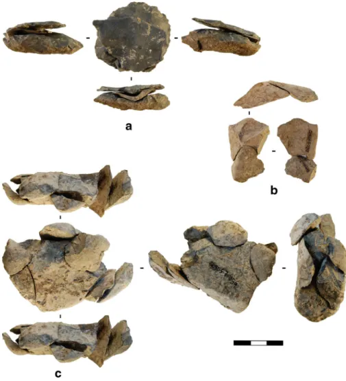
The fragmentation of the sample is very high: only 0.1% of the remains are
complete bones. Moreover, only 0.3% of the > 3-cm fragments are also > 5 cm
long. Anthropogenic fractures, of which 20% are green bone fractures, are found
on 67.6% of the determined bones; some fragments combine shaft and epiphysis.
Green fractures predominate in almost all the taxa, reaching percentages as high as
31.5% among Leporidae, 45% among Caprinae and 54.5% among Cervidae. In
Fig. 6 Refitting evidence from level IV: Levallois (preferential method) flakes refitted on their core (a); refitted limestone flakes (discoid method) (b); refitted limestone core of the chopping-tool type (c) Journal of Paleolithic Archaeologythe case of Equidae, the percentage is lower (9%) but, if we exclude the teeth,
comparable 38.3%. Among ungulates, long bone shaft fragments without a
com-plete circumference are the most common fracture morphotype (Fig.
3
). This type
Fig. 7 Combustion features in level IV of Quebrada: hearths (a–d); decapage surface showing both greyish sediments and the reddening produced by later occupations (e)stands for 88.1% of green fractures among Caprinae and for 92.3 and 96.4% of
such fractures among Equidae and Cervidae, respectively.
Eighteen fragments could be identified as shatter caused by percussion with a
stone tool (Fig.
3
), while 55 bear percussion notches and 66 other kinds of
anthropogenic modifications (mainly cut marks). These types of modifications
are mostly present on the remains of medium-size animals, although a cut mark
in the inner side of a completely calcined tortoise plate has also been recorded
(Table
4
; Fig.
3
).
The number of burnt bones is significant: 57% of the identified remains are
completely burned (Table
4
). Calcined bones predominate, followed by those in the
early stages of burning, showing a brown-black colouration. The highest values are
found among Testudinidae (74.2%) and Leporidae (47.8%), even though the
percent-ages among Caprinae, Cervidae and Equidae are no less significant (above 30% in all
three cases).
The correlation between %ISu and bone density suggests that the sample was
affected by post-depositional processes. Indeed, the correlation coefficient—0.58
(Equidae), 0.61 (Cervidae) and 0.76 (Caprinae)—is high for the three main taxonomic
groups and so is the positive probability.
Combining the Level IV Data
A synthetic, broader view of the role played by Quebrada in the settlement-subsistence
system(s) of the Middle Palaeolithic of the central region of Mediterranean Iberia
requires that the different lines of evidence be combined for overall assessment. Thus,
in the following, the results from the study of stone tools and faunal remains from level
IV are considered alongside the charcoal and phytolith data to address issues of spatial
Fig. 8 Stone tool economy in level IV of Quebrada: recycled pieces (a, g); rejuvenated (edge-resharpened) pieces (b, c, e, f) (d)
organisation, palimpsest formation, duration of occupation, hunting activity and
mo-bility patterns.
Spatial Analysis
As the distribution of lithic and bone remains well illustrates, the same area of the
shelter was repeatedly occupied (Figs.
4
and
5
). This is because of the limited
space available behind the drip line: about 4 m today, and narrowing as one moves
away from the central area of the site. As an example, Fig.
4
shows the
distribu-tion of the Caprinae remains (the best represented taxon) against the background
of the distribution of all faunal and lithic remains: finds are concentrated in the
interior area, corresponding to row 3 of the grid, and especially in columns E, G, I
and K (Eixea et al.
2011–2012
,
2012
), and decrease in density as we move
towards row 5 (squares C–K). Note, however, that the centre of each distribution
is different: while most lithics come from I3 and K3–5, most faunal remains come
from I3 and K3.
In the western zone (squares D, B and A), finds and features are in much lower
numbers. Conversely, middle- and large-sized blocks were more numerous in this
area. Most hearths are in squares C3, C4 and A4, as if marking a discrete
boundary between the two zones. Almost all the other hearths are in squares
G-I/5–6 and K5—as if marking the limits of the inhabited space to east and north—
and in close association with the densest patches of the distribution of both lithic
and faunal remains (Fig.
4
).
We compared the degree of bone fragmentation between the two areas of level IV to
see if there was any correlation between bone density and degree of fragmentation.
Based on the number of identified remains only, the percentage of < 3-cm fragments is
higher in the eastern area (33.6%) than in the western one (18.1%). Attempts have been
made to compare the number of complete versus incomplete bones, but there are so few
of the former that the results are not significant.
No bone refits could be done, due to the high level of fragmentation of the
remains and their poor conservation—often thermo-altered and with abundant
concretion covering. Stone tool refitting shows that the space available was used
in its entirety and that no structure relating to the clustering of activities, or of
individual occupation events, survived, or can be discerned (Fig.
6
) (Eixea
2015
;
Eixea et al.
2012
). The higher density of finds and features seen in the eastern area
correlates with this being also the area in which most refit links plot. Likely, the
explanation for both patterns lies in the fact that this is where the distance between
drip line and back wall is larger, this being therefore the most protected area of the
shelter.
Palimpsest
Level IV features dense lithic and bone scatters and many combustion features forming
a continuous distribution, with no sterile lenses, across the entire thickness of the
deposit, as is well apparent in vertical projection (Fig.
5
). This is due to a slow
sedimentation rate and corresponds to a typical palimpsest structure. The superposition
of combustion structures indicates that the shelter was used recurrently but, beyond
that, the record is not amenable to further precision as to the duration and specific
spatial properties of individual occupation events.
Fig. 9 Stone tools from level IV of Quebrada: transversal-convex sidescraper on Levallois flake, flint (A1); déjeté sidescraper on discoid flake, quartzite (A2); Levallois débordant flake with macro use-wear on the edge opposite to the méplat, flint (A3–A4); Levallois preferential flakes with macro use-wear, flint (A5–A9); Levallois preferential flakes with macro use-wear, flint (A10–A12); Levallois preferential micro-flake with macro use-wear, flint (A13); simple-convex sidescraper on discoid flake, flint (A14); natural backed knife, flint (A15); concave-convex, simple sidescraper opposite to méplat, flint (A16); denticulate, flint (A17); Mousterian point, flint (A18); déjeté micro-sidescraper, quartzite (A19); micro-pseudo Levallois point with use-wear on edge opposite the méplat (B1, B3); point with impact fractures (B2); detail of point with spalling by impact (B2); polish on ventral side of point (B4)
The compaction of multiple occupation events into a single, undifferentiated deposit
also contributes to explain the high degree of fragmentation of the finds: > 80% of the
lithics are chippage and > 90% of the fauna are small fragments. While this may be
related to human activity—e.g. on-site knapping and intensive recycling of blanks, in
the case of lithics, or carcass processing, in the case of bones—post-depositional
processes, namely trampling, clearly play a major role. Note that the charcoal remains
are also of a small size—on average, < 2 mm (Badal et al.
2012
).
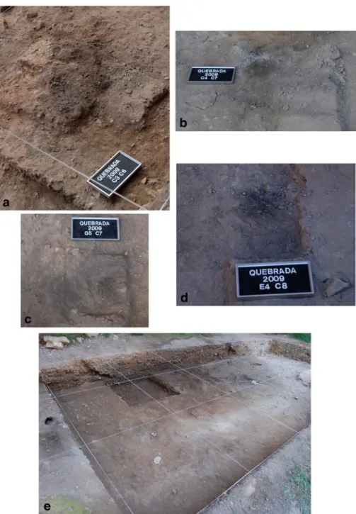
These factors also explain why hearths often lack a clear structure. They may have
been dismantled by subsequent activity (Fig.
7
), and the distribution of burnt phytoliths
includes areas devoid of combustion features, showing that ash scattered across the
entire excavation trench. Even though natural agency (e.g. winds) may explain such a
pattern to some extent, human agency (e.g. cleaning, trampling) must also be involved
(Esteban et al.
2015
).
Short Occupations
Individual occupation events seem to have been short, though recurring. Given its
position (northwest facing and at the bottom of a narrow, steep gorge), the shelter is
characterised by scarce insolation and high exposure to winds, making it unsuitable for
use in the winter. Indeed, human presence was restricted to between spring and autumn,
according to the ungulate seasonality data (Eixea et al.
2011–2012
), or more precisely
to between June and October, according to the phytolith data (Esteban et al.
2015
).
Species such as ibex and red deer are available throughout the year, given their low
migratory nature, but in the case of Quebrada, they were hunted on a seasonal basis.
Horse, a more migratory species that could have taken advantage of the region
’s natural
corridors for its displacements, seems, however, to have been hunted only in spring.
The reuse of pieces discarded in the shelter during previous occupations, and the
recycling of blanks and tools into cores, further supports the notion of recurrent
occupation (Rios et al.
2014
) (Fig.
8
). In turn, the high proportion of unretouched
blanks, the small size of the pieces and the predominance of local raw materials
(namely, the Levallois reduction of quartzite and limestone, despite the latter’s short
edge life) support the notion that such recurrent occupations were also short ones. This
notion is corroborated by the frequency with which scraper edges were resharpened:
26.9% bear traces of the procedure and, in many, it is also clear that discard happens
clearly before the potential for edge rejuvenation was exhausted, suggesting work
processes that were not lengthy.
The 29 combustion features identified are related to domestic activities and the time
investment involved in their preparation is in all cases small. Each hearth seems to
correspond to a separate event; no evidence was found for the simultaneous use of two
or more.
Hunting Activities
The Ahillas streambed runs through a canyon that opens onto a wide plain. The bottom
of the canyon being a dead end, it is easy to see how this natural trap could be used by
hunters and why Quebrada, located at the mouth of the canyon, was selected for shelter.
In addition, this location allows access to the different adjacent biotopes: mountain,
Table 5 Fin d de ns ity da ta fo r M iddle P al ae oli thic si tes of Me dite rr an ea n Ibe ri a (% ID. = % ide n ti fie d to ta xo n) General F auna Lithic Sources Density/m 3 Excavat ion ar ea (m 2) Thickness level (cm) T o tal Densit y /m 3 % Id . T o ta l/t ota l (wi tho ut kn app ing re ma ins ) Dens ity/m 3 Q ue b rada IV 19, 973. 80 30 20 100, 907 16, 817.80 1.3 0 18, 936/2331 3156/388. 5 S anc h is et al . ( 2013 ) VIII-1 116.5 23 10 2513 1092. 6 1.9 0 55/31 23.9/13. 5 E ixea ( 2015 ) VIII-2 1641 40 14,7 14 1599. 3 1.0 3 383 /97 41.6/10. 5 V illave rde et al. ( 20 17 ) VIII-3 1415 .7 10 3170 1378. 3 0.4 0 86/18 37.4/7. 8 El Sa lt X 752. 5 36 35 6590 523 – 289 2/ – 229.5 /– Gal v án et al . ( 2014a , b ) M ach ad o an d P ér ez ( 2016 ) Pastor IV a 57. 4 30 70 1 14 30. 2 1 8.40 18/ – 27.2/ – M ach ad o et al . ( 20 13 ) IVb 159 2 9 .60 522 /373 IVc 362 4 0 .90 31/ – Co va Negra II 566. 1 12 15 1012 562. 2 3 2.60 7/4 3.9/2. 2 V illave rde et al. ( 20 09 ) II Ia –b 786. 1 30 2795 776. 4 2 4.40 35/30 9.7/8. 3 M artínez V alle ( 2009 ) IV 636. 4 30 2289 635. 8 2 3.60 2/1 0.6/0. 3 Eixea ( 2015 ) B olo m o r IV -1 9042 .2 14 13 25,3 23 7864. 3 1 1. 30 379 3/184 6 1 178/573. 3 F ernández P eris ( 2007 ) Sa ñ udo an d F erná n d ez -Peris ( 200 7 ) IV -2 20 B las co ( 20 1 1 ) B en ei to D 1 (X ) 1221 .1 6 30 1476 820 1 3.80 722 /– 401.1 /– Itur be et al . ( 1993 ) D2 (X ) 3351 .5 3 2 2 1755 2659. 1 1 5 457 /– 692.4 /– Ma rt íne z V all e ( 1996 ) D3 (X I) 1081 .3 25 476 634. 7 1 8.30 335 /– 446.7 /– D4 (XII) 5497 .5 40 6264 5220 1 8.30 333 /– 277.5 /– R oma n í H 64. 8 220 10 1 165 53 1 3.50 261 /186 1 1. 9/8. 5 V aquero ( 1999 )
Ta b le 5 (c o n tin ue d) General F auna Lithic Sources Density/m 3 Excavat ion ar ea (m 2) Thickness level (cm) T o tal Densit y /m 3 % Id . T o ta l/t ota l (wi tho ut kn app ing re ma ins ) Dens ity/m 3 Va ll v er d ú et al . ( 20 05 ) R o se ll et al . ( 2012a ) I 116.6 195 1719 88. 2 1 2.90 555 /542 28.5/27. 8 V allverdú et al. ( 20 05 ) Ja –J b 176. 7 290 30 8460 97. 2 – 691 6/635 3 79.7/73 Rosell et al . ( 2012b ) Ja 210. 1 290 20 6738 1 16. 2 1 4.60 544 6/493 8 93.9/85. 1 V aquero et al. ( 201 2a , b ) Jb 491. 1 65 10 1722 264. 9 1 6.30 147 0/141 5 226.2 /217 .7 K 156. 2 279 2564 91. 9 6 1.70 179 4/120 6 64.3/43. 2 C hac ó n and Fe rnández -L aso ( 200 7 ) L 80. 5 260 1002 38. 5 4 6.80 109 1/982 42/27.8 V aquero ( 2008 ) Fernández -La so et al. ( 2010 ) M 138. 6 247 40 7614 77. 1 2 1.90 608 4/567 9 61.6/57. 5 C hacón ( 200 9 ) Fernández -La so et al. ( 2010 ) N 43. 6 170 10 200 1 1. 8 – 541 /– 31.8/ – Va ll v er d ú et al . ( 20 10 ) Oa –Ob 266. 5 271 45 9101 74. 6 5.3 0 23, 393/ – 191.8 /– Gabuci o et al . ( 2014 ) Oa 24. 7 25 486 7.2 – 1185/927 17.5/13. 7 B ar ga ll ó et al. ( 2016 ) Ob 107. 5 35 8615 90. 8 158 3/132 5 16.7/14 Ro ca N 1 0 – 95 10 –– – 360 2/ – 379.2 /– Ma rt íne z-M ore n o et al . ( 2010 ) D el s Bous N12 – 105 20 23, 560/ – 1 121. 9/ – de la T o rre et al . ( 2012 ) T eixon er es IIa 170. 3 20 40 696 87 9 8.90 45/33 5.6/4. 1 R osell et al . ( 2010 ) IIb 45 621 69 9 8.70 T ala m o et al. ( 2016 ) II Ia – 27 1585 293. 5 9 6.30 –/156 − 28. 9 IIIb 30 10,6 2 7 1771. 2 6 3.30 –/445 − 74. 2
plains and riverside. From such a home base, Middle Palaeolithic groups could have a
good control of the territory and hunt a wide range of prey, as indeed reflected in the
taxonomic diversity of the faunal assemblage.
The taphonomic study of the bone remains shows that carcasses were processed for
meat and marrow consumption. The evidence consists of longitudinal marks made with
stone tools (cut marks and scrapes), linked to the extraction of meat, and of percussion
breaks intent on fracturing long bones to access the marrow within (Fig.
3
).
Use-wear analysis of the stone tool points revealed the presence of impact fractures
and of hafting-related edge scarring (Eixea et al.
2015
) (Fig.
9
B). Additionally,
preliminary use-wear analysis of micro-flakes has shown that, in overlying levels II
and III, such items were used for butchering (Villaverde et al.
2012
). When accuracy is
more important than strength, the small size of these sharp-edge pieces is advantageous.
Mobility Patterns
The data on seasonality and duration of individual occupation events imply the
existence of additional points of settlement location, and the sourcing of the dominant
Domeño-type flint does show that it would have been procured from areas located 5–
8 km away (Eixea et al.
2011
,
2014
). Given the mobility patterns of prey such as horse,
ibex or red deer (Aura et al.
2002
), it is only logical to expect that their pursuit be
carried out from different sites, the use of which varied as a function of opportunity,
target species and time of the year. In the framework of such a settlement-subsistence
system, Quebrada would have been mostly occupied to hunt horse herds passing-by in
the spring and, possibly, between summer and autumn, too.
The allochthonous, good-quality flints found among the Quebrada lithics match
sources located > 100 km away, in the southern parts of the central Mediterranean
region, where a significant concentration of sites exists (Eixea et al.
2014
; Roldán et al.
2015
). For instance, the Serreta-type flint, present in small amounts at Quebrada, is
documented at such distant sites as Cova Negra (Xàtiva), Cova de les Cendres
(Teulada-Moraira) and El Salt (Alcoi) (Eixea et al.
2011
). The exploitation of these
raw materials indicates mobility along the natural corridors that traverse the Valencian
region from interior to coast and from north to south (Aura et al.
1993
). Whether this
reflects the mobility of individual Neanderthal groups over long distances or the
circulation of raw materials through exchange networks covering vast expanses of
Mediterranean Iberia, or both, remains to be clarified. However, the percentages of flint
from distant sources and their technological characteristics (low frequency of cortical
elements and predominance of items from the final phases of operational chains)
support the idea that the patterns reflect the transport of toolkits and, hence, the
movement of personnel.
Discussion
Density of Finds
The formation of an archaeological deposit depends on a wide range of factors that
cannot always be accurately characterised: territorial mobility patterns, duration of the
Journal of Paleolithic ArchaeologyTable 6 Site function indicators for Middle Pa laeol ithi c sites o f M editerr an ean Ibe ria (th e as ter is k d en ote s as sem b la ge s fo r wh ic h the p er cen tag e of to ols is calculated over the totalit y of the lithic as semblage, chippage included) Se dime ntation ra te s Dom ina nt tool typ es Fo rma l tools as a percentage of th e lithic ass em b la ge (c hip p ag e ex clu de d) Nu mb er o f fo rm al tools M ajor sp ecies (% NISP ) N IS P / MNI Queb ra da IV Lo w S id es cr ap er 20. 5 4 7 8 Cap rin ae (32) , T es tu din ida e (20 .4) , Eq uid ae (20. 4), C er vid ae (1 5.9 ), Lepo ri dae (10. 1) , Suidae/A ves/Rh inicerotidae/ Vu lp es /Ly n x, Per isso da cty la (1 ) 134 5/4 6 VII I Ra pid S id es cr ap er 14. 1 7 4 L epor ida e (6 0.8) , E q u id ae (1 7.9 ), C ap ri na e (1 2 .3 ), Ce rv ida e (6 .2) , A ve s/R hinocerotidae/Suidae/ Ca nid ae /C ar n iv or a/Bo v ida e/ C. lupu s/V . vu lp es (2. 7) 1149 /? El Sa lt X L ow S ide sc ra pe r –– Le por ida e (5 4.2) , C apr ina e (16 .8) , Cer vi nae (16. 1) , E qu ina e (9) , Ly n x/ Ca rn ivor a/ T estud inid ae/Bovinae/A ves/ Suin ae /Rhin o cer o tid ae / Ca nidae /Cu on/ Ca nis/ Pa nth er ina e/ Anur a (2. 8) 166 1/1 4 Pa sto r IV R apid S id es cr ap er 5.1 (I V b) 19 T . he rm an n i (6 0.4 ), C ap ri na e (19 .4) , Ce rvi n ae (6 .8 ), Equi na e (4.7 ), Rhin oc er otid ae (2 .2 ), A v es/ L ep ori d ae /Suin ae /Bov ina e/Ca nid ae (5 .9) 357 /1 1 Co va Negra II R apid S id es cr ap er 25 1 O. cuniculus (36) , A ve s (21 .4) , Hemitr agu s sp. (1 6 .7 ), C ap rina e (13 .6) , C. el a phu s/C. p yr enai ca/ D ama sp ./ B ov ina e/ Equu s sp ./Ca rni vor a (12 .4) 420 /? II Ia -b R apid S id es cr ap er 26. 7 8 O. cuniculus (46. 5), A ve s (26. 3), Hemi tragus sp. (7 .7) , Ca prina e/ C. pyr ena ica /Cervinae/ C. elap hus /Dama /C. capr eo lu s/Bovinae/ Eq uus sp. /Dice do ri nu s/ S. scr o fa/Casto r/Ca rn ivo ra (19. 5) 930 /? IV R apid S id es cr ap er 100 1 O. cuniculus (56. 4), A ve s (17. 5), Equu s (6 .2 ), C erv in ae (5 .5 ), Ca prina e (4.3), Hemit ragus sp . (3 .7) , C. el ap hus (2 ), Bovi na e/ C. lupus/ Hi aeninae/ Su s (2 .9) 653 /62 B o lo m o r IV L ow De n tic ulate 2 1 .3 3 94 O. cuniculus (27. 5), C. el ap hus (2 2.6 ), T . he rman ni (1 8. 4 ), B. pri migenius (7.4 ), A v es (6 .4) , H. cedr ensi s (4 .2) , S. sc ro fa (4 ), Dama (3 .2 ), E. fe rus/ H. amp h ib ius/ E. hy dr unti nus /Car nivo ra /P . antiquus /P . leo/C. lu pus /V . vu lpe s/L. p a rd in a/U. ar ct os/ M ac ac a/ Salmonidae (6.3) 286 4/9 9
Ta b le 6 (c o n tin ue d) Se dime ntation ra te s Dom ina nt tool typ es Fo rma l tools as a percentage of th e lithic ass em b la ge (c hip p ag e ex clu de d) Nu mb er o f fo rm al tools M ajor sp ecies (% NISP ) N IS P / MNI Beneito D1 (X) – Dent icu la te/ Uppe r Pal. 10. 4* 75 O. cuniculus (71. 7), C. p yr enai ca (1 1 .3) , A ve s (8.5 ), C. el ap hus (4 .6) , E. ca bal lus/ S. sc ro fa /B. p rimi ge nius /R. rupic a p ra/ C. lup u s/C. cr ocu ra/ L ynx /Bovi da e/D. sp. /L. cape ns is (4 .2) 185 6/? D2 (X) – Dent icu la te/ Uppe r Pal. 10. 9* 50 D3 (XI) – S ide sc ra pe r 1 1 .6* N D4 (XII) – Sid es cr ap er 18. 3* 61 Y (n = 1) Romaní H R apid Dent iculate 7 .5 14 I R apid Dent iculate 2 .2 12 Ce rvidae, B ovidae, E quidae – Ja –Jb Ra pid D ent icu la te 1.8 117 C. ela phu s (46. 9), E. fer u s (3 8. 7 ), B. pri migenius (8 .1) , S. hemi toe ch u s (4 .7) , R. p yr enaic a /Ca rn ivo ra /Ly n x sp ./ C. lup u s/Ur sus sp. /Cr osuta sp ./ V. vu lp es (1 .6) 126 5/1 5 Ja R apid D ent icu la te 1.8 8 9 Jb R apid D ent icu la te 2 2 8 K R apid Dent iculate 3 36 C. ela phu s (82. 5), E. fer u s (1 3. 8 ), B. pri migenius (3 .7 ) 406 /13 L R apid Dent iculate 3 .3 32 C. ela phu s (90. 6), E. fer u s (3 2. 1 ), B. pri migenius (5 .7 ) 106 /12 M R apid Dent iculate 0 .7 40 C. ela phu s (85. 7), E. fer u s 8 10. 1) , B. primi g enius (3 .7) , U. sp ale aus (0 .1) , C . cr oc uta (0 .1 ) 830 /20 N R apid Dent iculate –– C er vid ae , B ov ida e, E qu ida e, L ep ori dae ca . 200 /-ca . 3 Oa-Ob R apid Dent iculate –– C. ela phu s, F . silves tris , B. pri migenius , E. ferus , O. cuniculus , S . he mi toe ch is, A v es, Ursu s sp ., Rupic a p ra sp . 528 /21 Oa R apid D ent icu la te 1.8 1 7 Ob R apid D ent icu la te 5.7 7 5 N1 0 L ow De n tic ulate 4 * 1 45 ––
Ta b le 6 (c o n tin ue d) Se dime ntation ra tes Dominant tool typ es For m al to ols as a percent age of th e lithic ass em b la ge (c hip p ag e exc lu d ed ) Number of fo rm al tools M ajo r spe cies (% NIS P) N IS P / MNI Roca De ls Bous N12 L ow Sid esc ra pe r –– – – T eixoneres II R apid –– – C. ela phu s (3 8.7 ), E. fe rus (20. 7) , O. cuniculus (15) , Bos /Bison/S. scr o fa /C ar n ivo ra /Cap rin i/Hystri x sp ./ Rhinocerotidae (25.6) 406 /43 II Ia Rap id S id esc rape r 7.3 4 4 O. cuniculus (44. 1), E. fe ru s (1 9. 4 ), C. ela phu s (16. 3), U. spelaeu s( 8 .6 ), Bos /Biso n( 4 .4 ), C. sp ela es /Caprini/ Ca rnivora/ Hystr ix sp./ Rhinocerotidae/ S. Sc ro fa/ M . m ele s/ C . lupus/ C astor sp . (7.7 ) 710 /49 II Ib C. ela phu s (4 4.5 ), O. cu nicu lu s( 2 9 .6 ), E. ferus (10. 8), Bos /Bison (3 .4) , Ca rn ivor a/ R. ru p ic a pr a /U. sp el ae us /E. Hy drun tin us/L yn x sp. /C. sp el ae a/Lep u s/ R h in o cer o tid a/ V . vulp es/ S. scr of a/ Hyxtrix sp ./ M. mesle s/C asto r sp ./ Prob osc id ea (1 1 .7) 123 6/59 Game ta xa (s ma ll/ la rg e) An thr opo ge nic m od if ica tio n of bo n e re m ain s Non -a n th rop oge ni c mo dif ica tio n o f b one re ma ins S ea son ali ty H ea rt hs (y es /no) Source s Qu eb ra da 3 /7 C ut ma rks (1 .9% ), pe rc uss ion ma rk s (1 .6% ) 0 S pri ng-au tum n Y (n =2 9 ) E ix ea ( 201 5 ); pr es ent w or k 2 /10 Cut m ar ks (1% ), p er cu ssi on ma rks (2.5 % ) T oo th m ar ks an d d ige stio ns (1 .6 ) – Y( n =1 8 ) E ix ea ( 201 5 ); pr es ent w or k El Sa lt 3 /9 C ut ma rks (8 .9% ) and pe rc us sion ma rk s (2 .3% )* T oo th m ar ks an d di ge stio ns (1 .4) * Spri ng-sum me r Y (n = 4 6 ) Galván et al. ( 2014 a , b ), Machado and P érez ( 20 16 ), Pérez et al. ( 20 15 , 2017 )
Ta b le 6 (c o n tin ue d) Game ta xa (sm all / lar g e) An thr opo ge nic m odification of bo n e re m ains No n-an thr o po ge n ic mo dif ica tio n o f b one re m ains Seasonal ity Hearths (yes /no ) Source s Pa sto r 3/7 C ut ma rks (1 .9% ) an d pe rc us sio n ma rk s (2 .02 % ) T o oth mar ks an d d ige stio ns (1 .4 4) ?Y (n = 6) M ac ha do et al . ( 201 3 ), Pé re z et al. ( 20 17 ), Sa nc his et al. ( 2 015 ) C o v a Ne gr a 2 /8 0. 2 6 .4 Su m m er N E ix ea ( 201 5 ), Martínez V alle ( 1 996 ), V il lav er de et al . ( 200 9 ) 3/12 1 2 .2 8. 4 ? Y (n =/) 2/8 C ut ma rks and tooth ma rk s (2.8 ) D ig est ed bon es, ca rn ivo re ma rk s (6 .0 ) Summe r-spring Y (n =/) Bo lomo r 6 /12 cut marks (7 .18 %) , p er cu ssio n scars, tooth m ar k s to oth m ar ks , d ig estio ns (0 .56) ? Y (n = 3 ) B lasco et al. ( 2 013 ), Fe rn án dez P er is ( 20 07 ), Cu ar te ro ( 200 7 ) Be ne ito 3/10 Cut ma rks (1 .4% ) T o oth mar ks (1 .8) ? Y (n =1 ) It u rb e ( 199 1 ), Ma rt íne z V al le ( 19 96 ) N N Y( n = 1 ) Ro man í Y( n = 10) V aq ue ro ( 1 999 ) – Cut ma rks , b one br ea ka ge 1. 5 Y (n = 23) V al lve rd ú et al. ( 20 05 ) 0 /1 0 Cu t m ar k s (< 4% ), pe rc us si on ma rk s T o oth mar ks (0 .9, 0.2 ) S pr ing, autum n Y (n = 60) Ma rín et al. ( 201 7 ), Ro se ll et al. ( 2 012 b ), Va q u er o et al . ( 201 2a , b ) Y( n = 36) Y( n = 24) 0/4 C ut ma rks (4 .7% ), pe rc us sion ma rk s T o oth mar ks (2 .8) S umm er Y (n =/) C ha có n and Fer n ánde z-Las o ( 200 7 ), Ma rín et al. ( 201 7 ) 0/3 C ut ma rks (6 .7% ), pe rc us sion m ar ks (3. 4% ) T o oth mar ks (0 .8) S pr ing Y (n = 23) M ar ín et al . ( 201 7 ), V aqu er o ( 200 8 ) 1/4 C ut ma rks (6 .7% ), pe rc us sion m ar ks (3. 7% ) T o oth mar ks (0 .3) A ut umn -e ar ly winter Y( n = 37) Cha có n ( 20 09 ), Ma rín et al. ( 2 017 ) – 26 % –– Y( n = 19) V al lve rd ú et al. ( 20 10 )
Ta b le 6 (c o n tin ue d) Game ta xa (sm all / lar g e) An thr opo ge nic m odification of bo n e re m ains No n-an thr o po ge n ic mo dif ica tio n o f b one re m ains Seasonal ity Hearths (yes /no ) Source s 3/7 C ut ma rks (4 .9% ), pe rc us sion ma rk s Dige st io ns , too th m ar k s (3 6 re st o s) – Y( n = 63) B ar ga lló et al . ( 201 6 ), Gab u ci o et al. ( 20 12 , 201 4 , 201 7 ) Y( n =/) 75 Y( n =/) Ro ca De ls Bo us –– – – Y( n = 20) M or a et al. ( 2 008 , 20 11 –2 012 ) –– – – Y( n = 22) T ei xon er es 3/1 1 5 .6 (I Ia ), 5.7 (I Ib ) 8. 8 (II a) , 8 .1 (II b) W inte r-s umme r N Sá nc hez -Her ná nde z et al . ( 201 4 ), Ta la m o et al . ( 201 6 ) 3/8 C ut marks (1.6), p ercussion ma rks D igest ions, tooth m arks (25. 5) Multi-seas on N R os el l et al. ( 20 10 , 201 6) , S án che z-Hernández et al. ( 2 014 ), T ala mo et al. ( 20 16 ) 4/1 1 Cut m arks (3.3), percu ssion marks Digest ions, toot h m arks (6.8) M ulti-seas on
occupations, group size, availability of prey, raw material exploitation, seasonal
envi-ronmental variation and human demography. These factors converge to produce modes
of site use that, based on the composition of the archaeological assemblages that have
been analysed in our region (Gabucio et al.
2017
; Machado and Pérez
2016
; Machado
et al.
2013
; Rosell et al.
2012a
), are often reduced to two types: residential occupations
(‘camp sites’), and hunting or passing-by stands. When assigning specific occupations
to one of these types, the density of finds has been considered a relevant indicator.
However, samples of a large size and featuring a high density of finds—of which there
are numerous examples in Mediterranean Iberia, e.g. Abric Romaní, Teixoneres, Cova
Beneito, Cova del Bolomor or El Salt (Blasco and Fernández-Peris
2012b
; Gabucio
et al.
2014
; Iturbe et al.
1993
; Machado and Pérez
2016
; Rosell et al.
2010
,
2012a
,
b
)
—
can also be an artefact of the intensity of specific activities or of post-depositional
modification, namely of recurrent use in the context of low sedimentation rates. When
the degree of fragmentation is high, an additional problem is whether the cause lies in
anthropogenic, natural (e.g. carnivore activity) or post-depositional processes.
If we focus on the bone assemblages, the differences between sites are drastic
(Table
5
). For example, level IV of Quebrada yielded 16,817 bone remains per m
3,
compared to < 100/m
3in all the Abric Romaní levels for which data have been
published (e.g. levels H, I, K, M). Breakage patterns underpin this difference to a
significant extent. In the case of Quebrada IV, the correlation between %ISu and bone
density suggests that the primary cause for the fragmentation resides in the palimpsest
formation processes rather than in the intensity of human activities.
As ought to be expected, differences in the percentage of identified bones correlate
well with differences in their degree of fragmentation. Compared to Bolomor IV,
Beneito X or XII, Pastor IVb and Cova Negra II, in which the percentage of identified
remains ranges between 11 and 30%, the values are extremely low in Quebrada: 1.3%
in level IV and 1–2% in level VIII. In some assemblages, identification reaches 40%
(Pastor IVc, Abric Romaní L) to 60% (Abric Romaní K, Teixoneres IIIb), and even >
90% (Teixoneres IIa, IIb and IIIa). However, these higher values may reflect the
non-anthropogenic, at least in part, nature of the accumulations, as is clearly the case at
Teixoneres, where carnivores are a significant contributor of complete remains (Rosell
et al.
2010
).
The relative abundance of stone tools is a good indicator that a given
archaeo-logical deposit is largely anthropogenic. In this respect, level IV of Quebrada stands
out among the other Middle Palaeolithic contexts of Valencia and Mediterranean
Iberia as that featuring the highest density of lithic remains: excluding knapping
debris, 388.5/m
3. However, many of the Quebrada lithics are chippage, of which a
large part may be thermal and hence a post-depositional alteration product
second-arily generated by fire use rather than primsecond-arily generated by stone tool knapping.
Bearing this in mind, we can exclude such elements from the comparisons, but
doing so does not much change the picture; only Bolomor IV features comparable
numbers (Table
5
). Based on this indicator alone, one might conclude that Quebrada
was a major residential site, but the associated evidence shows otherwise. Thus,
even though reliable where it comes to assess the anthropogenic nature of a deposit,
the number and density of stone tool finds is, in and of itself, insufficient and may
be even misleading, where it comes to assess the type, duration and intensity of a
site’s human occupation.
The comparison with Abric Romaní is particularly striking and highlights the need
to consider the general context and nature of the sites involved in find density
comparisons. In cases such as Quebrada, the small size of the sheltered space implies
repeated use of the same area through the different occupation events, thereby
gener-ating high find densities. The opposite is the case at the Abric Romaní, where the much
larger space available for settlement makes for the spatial segregation of consecutive
occupation events. Such differences in site topography are compounded by potential
differences in the economy of the debitage (raw material procurement, degree of
fragmentation of the operational chains, reduction of stone tools via edge rejuvenation,
intensity of blank recycling) and in the mode of exploitation of the faunal resources
(seasonality, targeted prey, body part selection, transport and consumption patterns).
Correct interpretation of find density numbers requires adequate consideration of all
these factors.
Site Function
Depending on available data, site function can be approached in terms of the
permanency of the stays and of the nature of the activities, often expressed as a
dichotomy between residential and non-residential camps (e.g. knapping sites,
hunting or observation stands, procurement localities, travelling stops), or in
terms of the duration of individual occupation events and the size of the group
of occupants (Binford,
1980
; Kelly,
1983
,
2013
). Here, under the assumption that
group size is usually stable and features little variation (Bocquet-Appel and
Degioanni
2013
; Cucart-Mora et al.
2017
; French
2016
; Hassan
1979
; Hockett
and Haws
2005
; Sørensen
2011
; Zubrow
1989
), we focus our discussion on
length of occupation.
Such contexts as Abric Romaní (Gabucio et al.
2017
; Rosell et al.
2012a
), El
Salt X (Machado and Pérez
2016
; Pérez et al.
2015
) and Bolomor IV (Sañudo and
Fernández-Peris
2007
) have been classified as structured residential places
be-cause of the presence of hearths and the spatial distribution of faunal and lithic
remains (Table
6
), mainly a by-product of domestic tasks such as stone tools
knapping or the processing and consumption of prey. In addition, as has been
shown at Abric Romani (Vallverdú et al.
2010
), rest and waste-management areas
also exist. In all these sites, the hearths are the focal points structuring the
inhabited space and around which similar activities are carried out after
consec-utive occupation event. Mostly, such occupations have been defined as short and
recurrent, but it has been proposed that level J of Abric Romaní reflects longer
residency.
The patterns observed at Quebrada, Beneito, Pastor and Roca dels Bous are
slightly different. The area excavated at Beneito (3 m
2; Table
5
) is too small to
assess spatial patterns, but we note the high density of finds reflecting the
exploitation of a broad ecosystem (Iturbe
1991
; Iturbe et al.
1993
). This is
consistent with what we see at the other three sites, in which occupation is
seasonal, focused on basic subsistence activities such as the processing of the
hunt and the production of stone tools, and organised around hearths (Eixea et al.
2011–2012
; Machado et al.
2013
)—even though, for Roca dels Bous (Mora et al.
2008
,
2011–2012
), the corroborating faunal evidence is still lacking. All of this,
however, seems to take place, each time, around a single hearth, without the
spatial segregation of specific activities seen at the Abric Romaní.
Cova Negra and Teixoneres form a third category of contexts, ones
characterised by short duration and taking place between significant intervals of
abandonment. Alternating with periods of exclusive carnivore use (evident in the
number of carnivore remains and the percentage of bones bearing
non-anthropogenic modifications; Table
6
), the otherwise spatially restricted find
scatters excavated at these sites probably reflect limited occupation by
small-sized task groups (Talamo et al.
2016
; Villaverde et al.
2009
). This accords well
with the significant fragmentation of the lithic operational chains, implying that
stone tool knapping would have been carried out in exterior, non-excavated areas
of the caves or elsewhere in the landscape.
Subsistence
In all sites, hunting is the dominant subsistence activity and focuses on medium-sized
(Caprinae, Cervidae) and large (Bovinae, Equidae) prey (Table
6
). Access to the
carcasses is primary (even though, at Bolomor, carnivores were also partly involved
in the accumulation of ibex; Sanchis and Fernández-Peris
2008
), but body part transport
patterns show some variation. Species such as red deer and ibex were transported
complete to Quebrada or Abric Romaní. In other sites, transport is more selective, as
observed at El Salt or, in the case of horse, Quebrada. Carcass processing is intensive, as
shown at by the high fragmentation and extensive burning of the faunal remains.
As for small prey, leporids, birds or tortoises are also present, but the agent of
accumulation is not always the same. None of the small prey assemblages is 100%
anthropogenic, and only at Quebrada has no evidence of modification by other
predators been positively identified. Here, however, the exploitation of small prey
was not frequent (Salazar-García et al.
2013
). Even though the NISP of tortoise is
quite high and cut-marked tortoise plates have been found, the MNI of the taxon is
small (Sanchis et al.
2013
,
2015
); besides, its presence in the assemblage cannot
be unambiguously related to human activity, as is also the case with leporids.
At Cueva Antón (Sanchis
2012
; Zilhão et al.
2016
), El Salt (Machado and
Pérez
2016
), Bolomor (Blasco and Fernández-Peris
2012a
,
b
; Sanchis
2012
),
Beneito (Martínez Valle
1996
), Teixoneres (Rosell et al.
2010
; Rufà et al.
2014
)
and Abric Romaní (Gabucio et al.
2017
; Rosell et al.
2012b
), modification of
small animal remains by terrestrial carnivores and birds of prey, documenting
primary access or the scavenging of human leftovers, is well established; in most
cases, these non-anthropogenic accumulations are of leporids (e.g. at Cueva
Antón, El Salt or Bolomor). However, in some Bolomor levels, there is clear
evidence that leporids were, alongside tortoises, being consumed by humans
(Blasco
2008
; Blasco and Fernández-Peris
2012a
; Sanchis
2012
) and likewise at
El Salt and Abric del Pastor (Pérez
2014
; Sanchis et al.
2015
). However, the
contribution of small prey to diet was in general small and the observed inter-site
variation may relate to the duration and intensity of the occupations (Sanchis
2012
), as proposed for the Upper Palaeolithic (Aura et al.
2002
; Fa et al.
2013
;
Hockett and Haws
2009
; Stiner
2001
; Rillardon and Brugal
2014
; Villaverde et al.
1996
).
Conclusion
By combining the evidence from the study of its stone tool and faunal assemblages, we
have shown how the human groups responsible for the accumulation of the remains
retrieved from level IV of Quebrada exploited the different resources offered by the
environment in planned and flexible manner. These short-lived occupations display
little investment in the structuration of the space, the pursuit of a limited number of prey
taxa and a significant degree of fragmentation of the operational chains, with few refit
links and a lot of tool re-sharpening and blank recycling. The large size of the
assemblage relative to the area and volume of the excavation is misleading: it results
from palimpsesting processes, not from the length of occupations or the intensity of
activities. Comparison with other sites from the same area and period shows how this
type of site occupancy is widespread, even though often masked under assemblage size
and find density numbers that apparently suggest otherwise. As our results and
discussion hopefully have shown, such indicators need to be assessed in the context
of the associated evidence, namely that pertaining to seasonality, site function, mode of
introduction and processing of prey carcasses, and economy of the debitage.
Acknowledgments The authors would like to thank G. Smith, K. Rubens, T. E. Steele and T. Dogandzic for the invitation to the Session“Connecting Middle Palaeolithic datasets: the interplay of zooarchaeological and lithic data for unravelling Neanderthal behaviour” of the SAA Meeting (2017).
Funding Information Archaeological fieldwork and research at Abrigo de la Quebrada was funded by the Spanish Ministerio de la Ciencia e Innovación (HAR2011-24978, HAR2014-52671-P and HAR-2017-85153-P) and by the Generalitat Valenciana (PROMETEOII/2013/016 and PROMETEO/2017/060). NK was funded by the German Research Foundation (DFG), project F2 of the Collaborative Research Center 806 (“Our Way to Europe. Culture-Environment Interaction and Human Mobility in the Late Quaternary”).
References
Adler, D. S., Prindiville, T. J., & Conard, N. J. (2003). Patterns of spatial organization and land use during the Eemian Interglaciar in the Rhineland: new data from Wallertheim, Germany. Eurasian Prehistoy, 1(2), 25–78. Aura, E., Fernández, J., & Fumanal, M. P. (1993). Medio físico y corredores naturales: notas sobre el
poblamiento paleolítico del País valenciano. Recerques del Museu d’Alcoi, 11, 89–107.
Aura, E., Villaverde, V., Pérez Ripoll, M., Martínez-Valle, R., Guillem, P. M. (2002). Big game and small prey: Paleolithic and Epipaleolithic economy in the Spanish Mediterranean façade. Journal of Archaeological Metod and Theory, Special Issue“Advances in Paleolithic Zooarchaeology”, 1–57.
Azorit, C., Analla, M., Carrasco, R., Calvo, J. R., & Muñoz-Cobo, J. (2002). Teeth eruption pattern in red deer (Cervus elaphus hispanicus) in southern Spain. Anales de Biologia, 24, 107–114.
Badal, E., Villaverde, V., & Zilhão, J. (2012). Middle Paleolithic wood charcoal from three southern Iberian sites: biogeographic implications. Wood and charcoal. Evidence for human and natural history. Saguntum Extra, 13, 13–24.
Bailey, G. (2007). Time perspectives, palimpsests and the archaeology of time. Journal of Anthropological Archaeology, 26, 19–223.
Bargalló, A., Gabucio, M. J., & Rivals, F. (2016). Puzzling out a palimpsest: testing an interdisciplinary study in level O of Abric Romaní. Quaternary International, 417, 51–65.
Barton, C. M., & Riel-Salvatore, J. (2014). The formation of lithic assemblages. Journal of Archaeological Science, 46, 334–352.
Binford, L. R. (1978). Nunamiut ethnoarchaeology. New York (NY): Academic.
Binford, L. R. (1980). Willow smoke and dogs’ tails: hunter-gatherer settlement systems and archaeological site formation. American Antiquity, 45, 4–20.