i
The Contributing Factors of Large Wildfires
David Rodrigues Alves de Sousa
Exploring the main structural factors driving large
wildfire ignition and spread in central Portugal
(2005-2015)
Dissertation presented as partial requirement for obtaining
the Master’s degree in Statistics and Information
Management, with a specialization in Information Analysis
and Management
i
NOVA Information Management School
Instituto Superior de Estatística e Gestão de Informação
Universidade Nova de Lisboa
THE CONTRIBUTING FACTORS OF LARGE WILDFIRES: EXPLORING
THE MAIN STRUCTURAL FACTORS DRIVING LARGE WILDFIRE
IGNITION AND SPREAD IN CENTRAL PORTUGAL (2005-2015)
David Rodrigues Alves de Sousa
Supervisor: Marco Painho, Ph.D.
Co-supervisor: Frederico Cruz Jesus, Ph.D.
Dissertation presented as partial requirement for obtaining the Master’s degree in Statistics and Information Management, with a specialization in Information Analysis and Management
ii
AGRADECIMENTOS
Muitas foram as pessoas que me ajudaram e tornaram possível a elaboração desta dissertação. Em primeiro lugar, devo um agradecimento especial ao orientador, Professor Doutor Marco Painho, e ao co-orientador desta tese, Professor Doutor Frederico Jesus, pela sua disponibilidade, por todo o trabalho desenvolvido em conjunto e pelos conselhos e orientações imprescindíveis à elaboração deste trabalho.
À Professora Doutora Ana Cristina Ferreira, pela ajuda inestimável durante desenvolvimento da metodologia adotada e por tudo o resto.
Em igual medida, aos meus colegas Bartholomeus Schoenmakers, André Sousa e Sandra Lagarto no Instituto Nacional de Estatística, que disponibilizaram parte do seu tempo para me ajudar com inúmeras questões metodológicas ao longo do percurso e sem os quais o resultado deste trabalho não seria o mesmo.
À minha família, amigos e colegas pelo apoio que me proporcionaram todos os dias e pela motivação que me transmitiram sempre que necessário.
iii
ABSTRACT
Large wildfires have devastating human, environmental and economic consequences and are responsible for the majority of total burned area in Mediterranean Europe, even though they account for only a marginal portion of all fire occurrences. Most predictions suggest a global intensification of fire danger, and among all European Mediterranean countries Portugal displays the highest fire incidence. The purpose of this work is to examine the main factors driving large wildfire ignition and spread in central Portugal between 2005 and 2015, contributing with empiric knowledge on their importance and variability throughout the study area.
This research was successful at listing a comprehensive set of elements contributing to fire occurrence and at gathering data on these phenomena. Spatial cluster analysis was used to find homogeneous regions within the study area concerning the main factors influencing both fire ignition and burned area. Probit and two-part regression techniques were used to model the contribution of the different elements driving large fire occurrence and propagation.
The main findings of this analysis confirm the presence of spatial variability in the contribution exerted by most structural factors driving large wildfire ignition and spread in central Portugal. Additionally, while vegetation characteristics appear much more relevant for fire propagation, socioeconomic elements seem to be connected to fire incidence.
All in all, this research provides relevant input with implementation in different fields, from large fire awareness and prevention to the development of wildfire policies, as well as appropriate contributions to methodological concerns in fire danger and fire risk analyses.
KEYWORDS
Large wildfires; fire danger; large fire ignition; large fire spread; driving factors; spatial clustering; probit regression; two-part models
iv
RESUMO
Os grandes incêndios rurais têm como consequência impactos socioeconómicos e ambientais devastadores e são responsáveis pela maior parte do total de área ardida na Europa mediterrânica, ainda que representem apenas uma fração pouco expressiva do total de ocorrências. A maioria dos estudos prevê uma intensificação do perigo de incêndio, sendo que, entre todos os países europeus da bacia mediterrânica, é Portugal quem apresenta a mais alta incidência deste fenómeno. O objetivo deste trabalho é estudar os fatores que mais contribuíram para a ignição e propagação de grandes incêndios rurais no centro de Portugal entre 2005 e 2015, concorrendo assim com conhecimento empírico relativamente à sua importância e variabilidade na área de estudo.
Esta investigação conseguiu listar um conjunto abrangente de elementos que contribuem para a ocorrência de incêndios rurais, assim como reunir os dados necessários. Uma análise de clusters espacial foi aplicada para identificar regiões homogéneas dentro da área de estudo no que respeita aos principais fatores influenciando a ignição e o alastrar dos grandes incêndios. Modelos probit e em duas partes foram utilizados para analisar a contribuição dos diferentes elementos para a ocorrência e propagação dos fogos.
Os resultados deste estudo confirmam a presença de variação espacial no impacto exercido pela maioria dos fatores estruturais que contribuem para a ocorrência e propagação dos grandes incêndios rurais. Por outro lado, enquanto as características da vegetação se revelam mais relevantes na perspetiva do alastrar dos incêndios, os fatores socioeconómicos parecem estar relacionados com a ignição destes fenómenos.
Em suma, este estudo contribui com informação relevante, a implementar em diferentes âmbitos, desde a consciencialização das populações à prevenção e ao desenvolvimento de políticas na área dos fogos rurais. Este apresenta ainda contributos apropriados na área de metodologias de análise do perigo e risco de incêndio.
PALAVRAS-CHAVE
Grandes incêndios rurais; perigo de incêndio; ignição; propagação; fatores determinantes; análise de
v
CONTENTS
1. Introduction ... 1
1.1. Background and research development ... 1
1.2. Research goals ... 2
1.3. Study relevance ... 2
2. Literature review ... 4
2.1. Wildfires – some considerations ... 4
2.1.1. The consequences of wildfire events ... 5
2.1.2. An insight into fire dynamics ... 6
2.1.3. The role of human activities ... 8
2.1.4. The causes of wildfire ignition ... 8
2.1.5. The Portuguese wildfire protection framework ... 11
2.2. Wildfire risk assessment ... 12
2.2.1. Conceptual approaches to wildfire risk ... 12
2.2.2. Factors influencing wildfire ignition and burned area ... 13
2.2.3. Modelling wildfire danger ... 27
3. Methodology ... 29
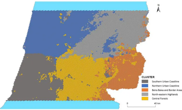
3.1. Study area ... 29
3.2. Data collection and processing ... 30
3.2.1. Wildfire events and burned area ... 33
3.2.2. Vegetation and soil factors ... 33
3.2.3. Cimatic factors ... 34
3.2.4. Topographic factors ... 35
3.2.5. Human factors ... 36
3.3. Data analysis ... 38
3.3.1. Exploratory univariate data analysis ... 39
3.3.2. Cluster analysis ... 39
3.3.3. Probit and two-part regression models ... 41
4. Results and Discussion ... 45
4.1. Large wildfire incidence ... 45
4.2. Main driving factors of large wildfire ignition and spread ... 45
4.3. Large wildfire ignition ... 46
4.4. Large wildfire spread ... 57
5. Conclusion ... 74
vi
LIST OF TABLES
Table 1 – Main objective and research goals ... 2
Table 2 – List of variables kept for the statistical analyses ... 46
Table 3 – Description of the ignition clustering solution based on the selected variables ... 48
Table 4 – Estimated models quality assessment measures (ignition) ... 50
Table 5 – Average partial effects (APE) and estimates significance (ignition) ... 50
Table 6 – Description of the propagation clustering solution based on the selected variables ... 59
Table 7 – Estimated models quality assessment measures (fire spread) ... 62
Table 8 – Average partial effects (APE) and estimates significance (fire spread) ... 62
Table 9 – Estimated OLS models dimension and quality assessment measures (fire spread) ... 66
Table 10 – OLS coefficients, associated t-scores and statistical significance (fire spread) ... 67
LIST OF FIGURES
Figure 1 – Large wildfire events and area burned by large wildfires, by cause of ignition, in Portugal (2005-2015) ... 9Figure 2 – Adopted wildfire risk framework, adapted from Chuvieco, Aguado, et al. (2014) ... 13
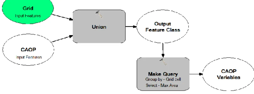
Figure 3 – Data integration for binary target (i) and proximity variables (ii) (respectively) ... 31
Figure 4 – Data integration for variables related to administrative units (iii) ... 31
Figure 5 - Data integration for other variables in shapefile format (iv) ... 32
Figure 6 – Data integration for interpolated climate raster variables (v) ... 32
Figure 7 – Data integration for topographic raster variables and mean annual precipitation (vi) ... 32
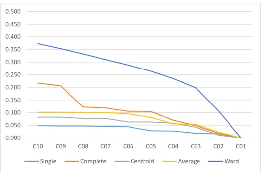
Figure 8 – R2 values associated to different clustering partitions and hierarchical methods ... 46
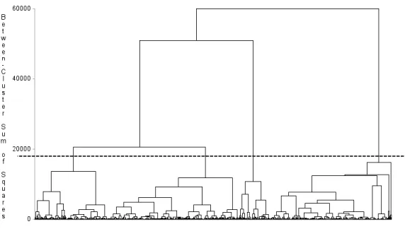
Figure 9 – Ward’s method dendrogram with the cut-off line at four clusters ... 47
Figure 10 – Main results of the ignition probit model ... 52
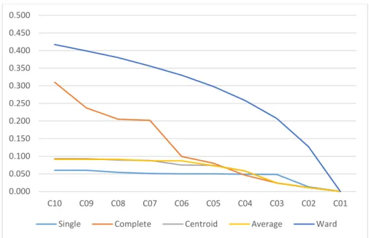
Figure 11 – R2 values associated to different clustering partitions and hierarchical methods ... 58
Figure 12 – Ward’s method dendrogram with the cut-off line at five clusters ... 58
Figure 13 – Main results of the fire spread model (part one) ... 63
LIST OF MAPS
Map 1 – The main causes of large wildfires, by district (2005-2015) ... 10Map 2 – Clustering solution (4 clusters) based on large wildfire ignition driving factors ... 48
vii
LIST OF ABBREVIATIONS AND ACRONYMS
CAOP Carta Administrativa Oficial de Portugal COS Carta de Ocupação e Uso do Solo DEM Digital Elevation Model
DGT Direção-Geral do Território FWI Fire Weather Index
GIS Geographic Information Systems
ICNF Instituto da Conservação da Natureza e das Florestas INE Instituto Nacional de Estatística
NOAA National Oceanic and Atmospheric Administration (USA) PNDFCI Plano Nacional de Defesa da Floresta contra Incêndios SAU Used Agricultural Surface
SNDFCI Sistema Nacional de Defesa da Floresta contra Incêndios WUI Wildland-Urban Interface
1
1. INTRODUCTION
This research seeks to investigate the main factors driving large wildfire occurrences in central Portugal between 2005 and 2015, focusing on their spatial patterns, dynamics and impact on the likelihood of fire ignition and burned area. This document is divided into 5 chapters: (1) the introduction; (2) a review of literary sources; (3) an account of the chosen methodology; (4) the presentation of the main findings of this work, complemented by a discussion; and (5) the concluding remarks.
1.1. BACKGROUND AND RESEARCH DEVELOPMENT
Fire is perceived as an important agent for both ecological development and deterioration of forest ecosystems around the world (Ferreira-Leite, Lourenço, & Bento-Gonçalves, 2013; Verde & Zêzere, 2010). In fact, even though fire has always be present as a landscape transformation and renewal factor (Goudie, 2006), fire events can have disastrous human, environmental and economic consequences, especially when these develop into large wildfires (Tedim et al., 2013).
Mediterranean Europe is particularly vulnerable to these destructive phenomena. This region is home to the second most diverse community of species worldwide after the tropics, and even though Mediterranean ecosystems are historically fire resilient, intense human pressure on the environment has favoured fire recurrence, has increased fire size and has made fire events overall more widespread (Moreno, Vallejo, & Chuvieco, 2013). Large fires play a significant role in this context because they are responsible for the majority of total burned area, while only expressing a small share of all fire events (San-Miguel-Ayanz, Moreno, & Camia, 2013).
These trends in fire dynamics have been observable across European Mediterranean countries, although at different rates. In Portugal, there is evidence of higher fire incidence than in other Mediterranean countries (Rego & Silva, 2014), a steady increase in the frequency of large wildfires and a rise in the extent of burned area during the second half of the 20th century (Ferreira-Leite et al., 2013). Climatic characteristics, land abandonment and other socioeconomic transformations have left the Portuguese inland territory susceptible to the occurrence of large wildfires (Oliveira, Pereira, & Carreiras, 2012), and climate change is expected to reinforce fire danger significantly (Rego & Silva, 2014).
One aspect that is important in shaping wildfire frequency and size is the role of humans and their activities, which is known to both stimulate fire ignition and prevent large burned areas. Human-caused fires represent 90% of all occurrences in the European Mediterranean (Moreira, Catry, Rego, & Bação, 2010), and in Portugal, the main known causes of forest fires are the use of fire, arson and rekindling (ICNF, 2014).
Wildfire risk is partially determined by fire danger, in which fire ignition and propagation likelihood play a central role (Chuvieco, Aguado, et al., 2014). In turn, the driving forces of fire occurrence and spread can be divided into vegetation and soil factors (the available fuel and its spatial continuity), climatic factors (favourable weather conditions), topographic factors, and human factors (usually, a source of ignition) (Ganteaume et al., 2013; Martínez-Fernández, Chuvieco, & Koutsias, 2013; Mhawej,
2 Faour, & Adjizian-Gerard, 2015). These structural elements display various relationships among themselves, explaining wildfire incidence and determining the behaviour of fire events.
1.2. RESEARCH GOALS
The overall purpose of this research can be summarised into one main objective and four specific research goals, as presented below:
Table 1 – Main objective and research goals Main Objective:
To study the main determinants of large wildfire occurrences in central Portugal between 2005-2015 as to their spatial patterns, dynamics and contribution.
Research Goal #1:
To recognise and to explain the main general factors driving wildfire ignition and spread, specifically in the Mediterranean context.
Research Goal #2:
To investigate the spatial patterns of large wildfire incidence and the distribution of the main drivers of fire occurrence and propagation.
Research Goal #3:
To identify homogenous regions within the study area with respect to the distribution of the main drivers of fire ignition and burned area.
Research Goal #4:
To model the occurrence and spread of large wildfires from the contribution of its main factors and to explore the variability of the factors importance among regions.
In order to accomplish these objectives, a comprehensive literature review on the factors driving wildfire ignition and spread will be carried out, along with multivariate data analysis techniques. Cluster analysis will be used to identify distinctive regions within the study area. Probit and two-part modelling procedures will be used to assess the influence of the main elements driving large wildfire occurrence and burned area, as well as the lack of stationarity across regions.
1.3. STUDY RELEVANCE
The relative influence of a great array of factors driving large wildfire occurrence in Portugal, in which we can count biophysical, land use, ownership and socioeconomic aspects, needs to be further studied for a richer understanding of fire dynamics. As Tedim et al. (2013) and Calviño-Cancela et al. (2017) put it, an insight into the various interactions among the main factors driving wildfire risk and fire behaviour – studying their arrangements, patterns and variations – should translate into an
3 improvement in risk management strategies, such as more efficient prevention measures, the development of existing regulation and the creation of campaigns aimed at increasing the awareness of different stakeholders in connection with specific activities and settings.
Additionally, a better understanding of wildfire occurrences and their spatial behaviour is essential for prevention efforts and firefighting planning, also in the legislative framework (Moreira et al., 2010). In fact, the spatial patterns of fire events are counted as one of the essential elements in wildfire danger assessment, and the study of these varying distributions helps understanding the reasons behind different fire regimes in otherwise similar regions (Rego & Silva, 2014).
The results of empirical studies in this area are still considered valuable input for model parameterisation in the perspective of risk analysis (Miller & Ager, 2013). There is a high degree of uncertainty involved in the study of wildfires, especially of those anthropogenic in nature, connected to deliberate, accidental and negligent causes (Rodrigues, Jiménez, & de la Riva, 2016).Furthermore, research studying large wildfires has not been very extensive in respect to their main factors, even though they are responsible for the majority of wildfire damages in the Mediterranean (Dimitrakopoulos, Gogi, Stamatelos, & Mitsopoulos, 2011; Ganteaume & Jappiot, 2013). Deeper insights into the mechanisms triggering large wildfire occurrence will hopefully provide the necessary knowledge to strengthen prevention efforts (San-Miguel-Ayanz et al., 2013).
The focus of this study will be on large events considering burned area, making use of the findings of previous works. This knowledge should result in beneficial developments in awareness, prevention and wildfire policies, and in advances in the effect mitigation of large wildfires (Ganteaume & Jappiot, 2013; Grala et al., 2017), specifically in the Portuguese context.
4
2. LITERATURE REVIEW
This chapter provides an indicative review of the main literary sources on this topic. To start, general considerations about wildfires are presented, as well as the most striking and important characteristics of large wildfire dynamics, specifically in the Portuguese context. Later, wildfire risk assessment frameworks are discussed and the main contributing factors of wildfires are described and explained. To conclude a short account of the methods used for analysing wildfire danger is given, with attention to the main goals of this research.
2.1. WILDFIRES – SOME CONSIDERATIONS
A quick look through the reference literature provides a list of different words or expressions to designate the phenomenon under study, from the most frequent wildfire and forest fire to a variety of other technical expressions. Mhawej, Faour and Adjizian-Gerard (2015) agree that a “wildfire is generally the unplanned or unwanted natural or human-caused fire that spreads over a minimum area of one hectare, where one or more types of vegetation are concerned” while asserting that the term
forest fire can be used interchangeably.
Although the latter is the preferred expression in Portuguese-language studies, the term wildfire appears to extend beyond the specific context of forest environments and is the most widely used expression in English-language academic settings and elsewhere, making it the choice of this study. Fire has a necessary and natural role in the environment as an agent for landscape transformation and wildlife development (Verde & Zêzere, 2007). Goudie (2006) discusses at length the different ways in which fire contributes to species diversity, pest control and vegetative reproduction. However, wildfires also represent the source of great destruction to forested and populated areas alike, with recent examples of extensive damage in Greece and other regions with Mediterranean characteristics (Mitsopoulos, Mallinis, & Arianoutsou, 2014), including Portugal. All in all, Ferreira-Leite, Lourenço and Bento-Gonçalves (2013) consider it to be a fundamental aspect of ecological development or deterioration of global forest environments.
In the literature, the expression large fire is used to identify all wildfires that either have the possibility of developing into very large fires or are liable to burn a large area, while the size varies depending on the author or study (Ganteaume & Jappiot, 2013).
In line with the Resolution from the Portuguese Parliament n. 35/2013, of March 19th (Resolução da Assembleia da República n.º 35/2013, de 19 de março in Diário da República n.º 55/2013, Série I), large wildfires refer to all events with a burned area over 500 ha, replacing the previous institutional classification which considered all occurrences with a burned area over 100 ha (Ferreira-Leite et al., 2013). It is important to mention, however, that this second threshold is still widely used in the reference literature to identify large wildfires, and represents the classification used in this research work.
On the other hand, there is an important difference between large fires and mega-fires, which represent a specific subgroup of the former. These are considered complex, multidimensional and unusual events, specifically in what concerns burned area extension, damage severity and associated
5 firefighting efforts (Dimitrakopoulos et al., 2011; Tedim et al., 2013). According to San-Miguel-Ayanz et al. (2013), megafires can be charcaterised on the basis of their damaging impacts, specifically economic losses and human casualties. Tedim et al. (2013) also mention the main attribute of these phenomena to be their short and long-term impacts.
2.1.1. The consequences of wildfire events
The negative consequences of wildfires are several, wide-ranging and are well documented throughout the literature. Tedim et al. (2013) separate direct damages and indirect losses, stressing the environmental and economic impacts of fire events inside and outside the burned area, even though many times, in Portugal, damages are measured as a sole function of burned area size. These same authors consider that wildfire impacts may be classified as to their type and their spatial and temporal scales, for a comprehensive assessment and monitoring of this phenomenon.
According to Oliveira, Pereira and Carreiras (2012) the three decades of intense fire activity starting in 1980 and ending in 2010, in Portugal, have resulted in a replacement of large areas of maritime pine forests for eucalypt plantations and shrublands, with all the negative conditions it entails for future fire regimes. Ricotta and Di Vito (2014) agree that, in Mediterranean ecosystems, recurrent wildfires are found to thoroughly disturb landscapes, reducing biodiversity and favouring the growth of shrubland areas, since many species require a sufficiently longer time interval to regenerate. In turn, this degradation promotes wildfire occurrence, given the apparent lower value of such areas. Countless other environmental dangers have been verified, such as the aggradation of rivers, which is a real danger in the Mondego basin in central Portugal (Ferreira-Leite, Lourenço, et al., 2013).
On the other hand, wildfires pose numerous threats to human lives, their resources and their activities (Chuvieco, Aguado, et al., 2014), namely a serious impact on the forestry sector, reducing earnings and decreasing investment (Álvarez-Díaz, González-Gómez, & Otero-Giraldez, 2015) and negative economic effects on the farming activity, damaging machines, burning profitable crops and killing animals (Tedim et al., 2013). It is expected that demographic changes increase wildfire impacts on human safety, as in some areas of the world, such as California, the urban sprawl has provided a source for rising ignition risk in particularly vulnerable settings (Keeley & Syphard, 2016).
In the words of Moreno, Vallejo and Chuvieco (2013), the Mediterranean Europe is currently classified as degraded, as a consequence of long-term human presence and exploitation. This anthropogenic impact is known to influence both wildfire occurrence, as well as the ecological response to such extreme events. Additionally, destructive effects are more likely to ensue as a result of a high number of infrastructures and a prevalence of densely populated areas, particularly during the summer months.
Other important aspects include carbon emissions (Amiro et al., 2001; van der Werf et al., 2003), and high economic impacts, especially connected to fire suppression (Westerling & Bryant, 2007), other aid expenditures, like evacuation procedures, and the recovery process (Tedim et al., 2013). In fact, Moreno, Vallejo and Chuvieco (2013) acknowledge that more than 2.5 billion euros are spent every year in prevention and suppression across the European Mediterranean region.
6 When focusing specifically on the consequences of large forest fires, great damages are an expected outcome. The work of Tedim et al. (2013) covering the mega-fires occurred in Algarve, south of Portugal, in 2003, gives an account of the effects of these extreme events on dwellings, forests and agricultural lands, the shortage of stored water and the destruction of power and telephone lines. An association has been made by the same study between these high damages and the location of the wildfires, which spread to areas on the Wildland-Urban Interface, where human presence is dispersed and elements are particularly vulnerable.
Conversely, Künzli et al. (2006) have demonstrated that health effects on children, namely respiratory conditions, are one of the serious concerns of smoke from large wildfires, while Dimitrakopoulos et al. (2011) have focused their attention on the high costs of firefighting, particularly due to extended suppression times and the use of airborne means.
It is worth considering the perceptions of different stakeholders when discussing the main effects of wildfires. A study conducted in the Portuguese municipality of Mação (NUTS III Médio Tejo) has shown that, while forestry technicians mentioned soil erosion and the loss of biodiversity as their main concerns, the local community pointed out the loss of timber and the destructive impacts to the local economy and private property (Ribeiro et al., 2015).
2.1.2. An insight into fire dynamics
The term fire regime defines the regular and constant features of wildfire behaviour and dynamics occurring in a given area over a period of time (Jiménez-Ruano, Rodrigues, & de la Riva, 2017). According to Seol, Lee and Chung (2012), fire regimes differ in size, regularity, pattern, intensity, type, magnitude and seasonality of fire occurrences.
There is evidence of an increasing frequency and severity of wildfires over the 2nd half of the 20th century (Ferreira-Leite et al., 2013). Holsinger, Parks and Miller (2016) argue that this trend is related to forest fire deficits created by a decrease in the prevalence of managed wildfires. In fact, there is evidence of a rise in wildfire occurrences in the Mediterranean during the 1990s. However, since 2000 a noticeable but inconsistent decrease has been witnessed by some researchers (San-Miguel-Ayanz et al., 2013).
In Portugal, where the territory is already prone to this phenomenon as a result of climatic characteristics, population-related and socioeconomic transformations, as well as climate change, have reinforced susceptibility (Oliveira et al., 2012). This tendency is only expected to become more prominent for Portugal and other Mediterranean countries given future predictions of warmer and drier weather, in connection to structural changes occurring to the social and economic systems (Moreira et al., 2010; Rego & Silva, 2014).
While increasing frequency is an alarming scenario, given that short wildfire recurrence produces the most hazardous impacts to land degradation (Ricotta & Di Vito, 2014), an increase in severity has given way to wider-ranging damages, specifically to the environment, property and human life (Álvarez-Díaz et al., 2015). A clear example of more severe fire regimes is a general intensification of burned area. Although there is evidence of large wildfires occurring in Portuguese territory in the 19th century, their frequency has been steadily rising during the last three decades (1980-2010), and a very substantial
7 increase in the extent of burned area has been witnessed, with the last decade accounting for more than 1 million burned hectares (Ferreira-Leite, Lourenço, et al., 2013). For the southern Europe and elsewhere, there is ample agreement in the literature that large fires (>100 ha), which represent a marginal portion of all occurrences, are responsible for the great majority of total burned area (Dimitrakopoulos et al., 2011; Ganteaume & Jappiot, 2013; Moreno et al., 2013; Ricotta & Di Vito, 2014; San-Miguel-Ayanz et al., 2013).
Nevertheless, the analysis conducted by San-Miguel-Ayanz et al. (2013) for a series of countries in the Mediterranean basin, including Portugal, has failed to prove a growing trend in the number of large fires in the last decades. In fact, there is evidence of negligible variability in the number of large occurrences throughout the years and even a slight decreasing trend.
In Portugal, the same human-induced changes linked to an increase in wildfire risk, specifically what concerns population trends and land cover transformations, are believed to be responsible for more extensive burned areas (Moreira et al., 2010). Nevertheless, some authors suggest that their occurrence follows a cyclic behaviour, either connected to post-fire vegetation dynamics (Moreira et al., 2010) or to prolonged drought periods (Ganteaume & Jappiot, 2013).
When compared with other countries from the European Mediterranean region, there is evidence of higher fire incidence in Portugal (Moreira et al., 2010; Oliveira et al., 2012). Nevertheless, Oliveira et al. (2012) go on to describe the substantial regional variability of this phenomenon: the north is dominated by short fire recurrence intervals, frequent and overall small events considering burned area, and is mainly composed of shrubland; the central region, composed predominantly of forested areas, is also characterised by short intervals between wildfires, where occurrences are not many but usually originated large burned areas; apart from Algarve, in southern Portugal fire intervals are longer and burned area is small, considering its composition of mostly agricultural land.
The results from the work of Moreira et al. (2010) agree with these statements, since the places where most ignitions occur do not correspond to the locations subject to large burned areas. Whereas ignitions seem to be mostly related to the presence of human activities, depopulated areas seem to be more susceptible to fire spread. Therefore, wildfire events igniting along the oceanic shore or in the south of the country are more likely to remain small, while wildfire occurrences located near the eastern border with Spain, in the central and north-eastern regions or in the mountains in Algarve (south) have a greater probability of spreading to large areas, which is a similar pattern to that identified by Tedim et al. (2013).
Other authors have reached the same conclusions, as is the case with Rego and Silva (2014). They confirm there are clear geographical differences, in Portugal, between the distribution of ignitions developing into large wildfires and that of smaller sized occurrences. They also sustain that the role of wildfire effects differs among regions, which is a firm demonstration of the variability of fire dynamics. Future perspectives on fire regimes cannot be detached from global climate projections, specifically in the Mediterranean. Several studies agree on the most distinctive foreseen weather patterns for this region of the world. Global warming will translate into an irreversible increase in annual temperatures and a rise in the intensity and frequency of heat waves. Moreover, it will represent a decrease in precipitation and wet days and an intensification of drought periods (Keeley & Syphard, 2016; Moreno et al., 2013; Rego & Silva, 2014). All in all, these conditions represent a rise in fire danger and imply an increase in the duration of the fire season (San-Miguel-Ayanz et al., 2013)
8 Adding to these aspects, the process of land-use changes is believed to keep affecting fire dynamics in southern Europe, either related to land abandonment or to a decrease in agricultural areas promoted by the Common Agricultural Policy (CAP) (Moreno et al., 2013).
All these elements bring about significant impacts to wildland and urban landscapes and suggest an increase in wildfire risk, especially regarding the occurrence of large fires (Moreno et al., 2013). However, climate change might also trigger a decline in fire severity, given the effects of drier and warmer weather on fuel availability (Keeley & Syphard, 2016).
2.1.3. The role of human activities
The role of humans and their activities in shaping wildfire size and frequency is multidimensional, representing both causative and deterrent aspects. Man has been an important player in the transformation of ecosystems since he has been able to control fire (Chuvieco, Aguado, et al., 2014), and this long-lasting impact is known to have altered fire regimes in most regions of the world (Rego & Silva, 2014), reducing fire-return intervals considerably (Moreno et al., 2013).
Long and concentrated human presence, together with weather features and the presence of flammable vegetation, has shaped fire regimes in the Mediterranean, making it susceptible to wildfire occurrence (Dimitrakopoulos et al., 2011; Ferreira-Leite et al., 2013). Although in some parts of the world natural ignitions are the origin of up to half of all fires (Goudie, 2006), and propagation is favoured from natural elements such as fuel availability and low humidity, the European Mediterranean faces an overwhelming preponderance of human-caused wildfires, which represent more than 90% of all wildfires in that region (Chuvieco, Aguado, et al., 2014; Moreira et al., 2010; Rego & Silva, 2014; Rodrigues et al., 2016; San-Miguel-Ayanz et al., 2013; Vilar et al., 2016).
The public report containing the analysis of wildfire causes in Portugal, for the period 2003-2013, goes as far as attributing 98% of all investigated fire occurrences to humans, either intentionally or negligently (ICNF, 2014). In fact, anthropogenic factors are the main structural elements influencing geographic and temporal ignition patterns in Portugal, as several studies have demonstrated (Rego & Silva, 2014).
Even though the proximity to human settlements has an overwhelming effect on wildfire dynamics, this effect is not necessarily harmful. A positive aspect connected to the importance of human factors for fire incidence and behaviour stems from our ability to better predict these events (Moreno et al., 2013), and therefore plan ahead to prevent them. Moreover, humans are a key element of fire suppression, reducing fire severity (Rego & Silva, 2014).
2.1.4. The causes of wildfire ignition
The understanding of the ignition sources and generic causes of wildfires is an integral part of the study of this phenomenon and of its main determinant factors. Some authors agree that the ignition typology has impact on fire behaviour and dynamics, particularly the extension of burned area, as well as wildfire frequency, duration and patterns (Ganteaume & Jappiot, 2013; Grala et al., 2017; Moreno et al., 2013). However, caution is necessary when analysing this information, since there is an associated component of high subjectivity related to the work of technicians (Álvarez-Díaz, González-Gómez, & Otero-Giraldez, 2015; Grala et al., 2017).
9 According to ICNF’s report on the causes of forest fires in Portugal during the period 2003-2013, 76% of all events registered in the mainland have been subject to police investigation (ICNF, 2014). This has been standard procedure since 2006, when forest rangers were assimilated into the military police force (GNR). During this decade a considerable amount of inquiries were inconclusive; this occurred to 28% of all investigated events in 2013.
The methodology selected for the investigation of wildfire causes relies on physical evidences, since 1991, such as fire behaviour patterns and other indicators. The categories linked to wildfire causes comprise an extensive list of 71 subclasses, which distinguish specific activities and conducts and can be grouped into seven main types: use of fire, accidental, structural, arson (intentional), natural, undetermined and rekindling.
Between 2003 and 2013, the majority of wildfires whose cause has been determined was attributed to the use of fire (e.g. fires, debris burning, smoking; at around 30%), to arson (approximately 25%) and to rekindling (around 15%). Wildfires originated by the use of fire, although very frequent during this period, resulted in small burned areas, whereas natural or machinery (accidental) caused fires represented the vastest burned areas. The districts of Santarém, Braga and Viana do Castelo are identified as the regions most associated with intentional causes, specifically arson.
When focusing specifically on large wildfires (>100ha), data for the period of 2005-2015 and the two graphs below (Figure 1) show that the single most common cause typology refers to arson without an apparent reason (vandalism), standing at about 35% of all occurrences whose inquiries were successful, followed by the use of fire for grazing purposes (roughly 23%). The largest burned areas can also be attributed to these two causes (38% and 16%, respectively), as well as to other intentional sources (8%) and fire rekindling (6%). Overall, the grounds for a total of 570 occurrences, which represent more than 1/3 of all large fire events and around 1/3 of all burned area during this decade, were left undetermined.
Figure 1 – Large wildfire events and area burned by large wildfires, by cause of ignition, in Portugal (2005-2015) 51% 43% 2% 4%
Large wildfire events (%)
54% 38%
2% 6%
10 An analysis of the spatial distribution of the main causes of large wildfires, in mainland Portugal, shows a balance among districts in respect to the most common category connected to fire events, between intentional motivations and accidental or use of fire sources. As shown on the first map below (Map 1), there is a clear contrast between north coastline and south and inland areas in this case. When considering only burned area extent, however, there is a higher incidence of deliberate causes throughout the territory (addition of Vila Real and Portalegre). It is interesting to realise that large wildfires originating from unknown causes were common in Aveiro (85%), Castelo Branco (76%) and Porto (68%), during this period.
Map 1 – The main causes of large wildfires, by district (2005-2015)
Arson is a particular aspect among human motivations. Álvarez-Díaz et al. (2015) underline the importance of this phenomenon in northern Portugal and Galicia, stemming from social conflicts, while Ganteaume and Jappiot (2013) describe it as the most frequent cause of wildfires in southern France, mostly related to the interests of hunters, shepherds and real estate mediators. This last study has been successful in associating arson and burned area, giving emphasis to its role in the occurrence of large wildfires.
It is interesting to observe that the perception of the main causes driving fire spread is not exactly coincident among stakeholder groups. Returning to the results of the study conducted in the Portuguese municipality of Mação regarding the perspectives of different stakeholders on the subject of forest wildfires, local forestry technicians mentioned the density of fuel accumulation, specifically shrub, and the type of vegetation as the most important aspects favouring the propagation of fires. Local community respondents have referred shrubland areas as well, while favouring the role of weather conditions (Ribeiro et al., 2015).
11
2.1.5. The Portuguese wildfire protection framework
Forest protection against wildfires is regulated in Portugal in the framework of the National Plan of Forest Protection against Wildfires (PNDFCI) and the National System of Forest Protection against Wildfires (SNDFCI). These are established in the scope of comprehensive legislation which arose from the need for a modern framework tackling the issue of forest fires in Portugal, in the wake of tragic wildfire events which affected the country in 2003 and 2005 and set new burned area records (C. Ribeiro et al., 2015). In fact, some authors mention wildfire catastrophes as powerful drivers of change in forest administration in different Mediterranean regions (San-Miguel-Ayanz et al., 2013).
The National Plan of Forest Protection against Wildfires stems from the Resolution of the Council of Ministers n. 65/2006, of May 26th (Resolução do Conselho de Ministros n.º 65/2006, de 26 de maio in Diário da República n.º 102/2006, Série I-B), establishing forest protection measures, lines of action and political reforms aiming at increasing the efficiency of forest management and reducing the number of wildfire occurrences (Viana, 2010). The SNDFCI was created shortly after the creation of the PNDFCI in order to regulate and specify the general measures presented on the national plan. The Decree n. 124/2006, of June 28th (Decreto-lei n.º 124/2006, de 28 de junho in Diário da República n.º 123/2006, Série I-A) established the measures to be developed under the SNDFCI. This regulation has been subject to five revisions since its first publication, the last of which took place in 2017 and strengthened the role of the military in firefighting and prevention actions. However, the general aspects of the document, including the responsibilities of the different stakeholders, have been kept constant throughout the years.
According to this legislation, three action axes define the National System of Forest Protection against Wildfires, which together convey the protection of people, property and the forest: (1) structural prevention; (2) vigilance, detection and inspection; and (3) firefighting and post-fire vigilance (C. Ribeiro et al., 2015). The responsibility for each of these pillars belongs to a specific entity, with the Nature Preservation and Forests Institute (ICNF) coordinating awareness and planning actions, the police (GNR) taking charge of operational aspects such as alertness and assessment, and the National Authority for Civil Protection (ANPC) managing the combat and post-fire vigilance stages (Viana, 2010). Apart from these overarching concerns, the Decree contemplates a reference to the different levels of planning. In reality, districts and municipalities have in their structures specific branches in charge of producing local forest protection plans and managing the participation of different stakeholders into this process (C. Ribeiro et al., 2015). Additionally, it legislates on the circumstances where the use of fire is not allowed, specifically in relation with fire-weather information, and the foreseen practices regarding wildfire detection and alarm (Viana, 2010).
Although one of the three main pillars of the Portuguese framework of protection against wildfires stands for structural prevention, some experts criticise the present paradigm as predominantly reactive, focusing efforts on firefighting (Rego & Silva, 2014). This fact can be demonstrated by the disproportionate annual resource allocation in the context of the SNDFCI: 1/3 for prevention and 2/3 for firefighting (according to the Portuguese State Secretary for Forests, Miguel Freitas, in “Não me
12 It is important to note, however, that forest fire protection corresponds to one branch of the current Portuguese forest planning framework, which encompasses the broad technical and policy areas of forest management, forest health and desertification. Together, these comprise the four main levels of the Portuguese Forest Planning System (Pinho, 2014).
2.2. WILDFIRE RISK ASSESSMENT
2.2.1. Conceptual approaches to wildfire risk
The importance of gathering knowledge on the destructive characteristics of this phenomenon has led to the development of many studies on wildfire risk assessment. This is seen as a critical stage in resource planning, fire prevention and fire management activities generally speaking, by approximating the times and places most susceptible to increased wildfire occurrence and damages (Chuvieco, Aguado, et al., 2014).
According to several authors, the main guiding principles of risk analysis transpose soundly to the field of wildfires, for its focus on stochastic events of extreme consequences (Miller & Ager, 2013). Fire is a process determined by probability (Oliveira et al., 2012; Seol et al., 2012). As such, wildfire risk is the product of aspects related to ignition and burning likelihood, as well as a component linked to fire intensity and effects, in which propagation, damage and the difficulty of fire control are contemplated (Cao et al., 2013; Mhawej et al., 2015; Moreira et al., 2010).
Miller and Ager's (2013) wildfire risk assessment framework follows this general structure. As they see it, wildfire likelihood can be predicted from ignition probability, or simply the probability of burning, accounting for subsequent fire spread. On the other hand, fire intensity and effects, which are closely related in most models and come together to denote hazard, refer respectively to fire behaviour and the positive or negative modifications in environmental, social and economic values affected by this phenomenon.
On a similar yet distinct note, Mitsopoulos et al. (2014) refer to fire behaviour individually as a specific component of wildfire risk, underlining the view of some authors who identify it as the “likely behaviour given that a fire does occur”. As we have stated before, in many contexts, the occurrence of specific fire types is natural and represents a necessity. This component of wildfire risk is also stressed by Tedim et al. (2013), which consider fire intensity, connected to the release of energy, and rate of propagation separate from the effects and possible damages of wildfires.
These views are enriched by those of Chuvieco, Aguado, et al. (2014), which recognise wildfire risk as a result of both fire hazard (used interchangeably with danger) and ecosystem vulnerability. Nevertheless, while Miller and Ager (2013) understand hazard as a combination of fire intensity and effects, separate from the probability of fire occurrence, for the first authors it encompasses ignition and propagation danger and is explained by the specific driving factors affecting these two fire components.
In fact, terminology has been an unlimited topic of discussion among researchers in this area of knowledge. Bachmann and Allgöwer's (2001) efforts in consistent language standardisation have originated a set of concepts borrowed from the field of technical risk engineering. These authors agree
13 with Chuvieco, Aguado, et al. (2014) in what concerns the general notion of wildfire risk, integrating both the probability of fire occurrence and the chance of damage, i.e. vulnerability.
However, fire hazard is perceived by these authors as the phenomenon itself, distancing itself from the preconditions that drive fire incidence, as mentioned by Chuvieco, Aguado, et al. (2014), and from the potential damage given a fire event stressed by Miller and Ager (2013). Conversely, the term “danger” is deemed by these authors too subjective and abstract to be of any relevance to the field of study.
As mentioned before, the concept of fire risk is not complete without vulnerability. It refers to the susceptibility of communities to the effects of wildfires, or simply the magnitude of the damages they entail, whether environmental or economic (Chuvieco, Martínez, Román, Hantson, & Pettinari, 2014). It should be noted that it considers the time of recovery after the event and the adaptive capacity of landscapes (Chuvieco, Aguado, et al., 2014; Miller & Ager, 2013)
Some authors believe that vulnerability also affects hazard itself, by identifying the main human, economic and ecological values that drive firefighting operations (Chuvieco, Aguado, et al., 2014), thus influencing fire behaviour and spread. Additionally, Tedim et al. (2013) agree that the different categories of effects play a bigger role in wildfire risk, interacting with fire behaviour, the landscape and firefighting to outline fire severity.
The wildfire risk assessment framework defined in this study (Figure 2) draws extensive influence from the works presented above. This characterisation is important in the context of the identification of the main contributing factors of large wildfires in central Portugal. Even though the vulnerability component of fire risk stands beyond the scope of this study, its impact on fire danger is mentioned in connection to specific human and physical variables influencing fire spread.
Figure 2 – Adopted wildfire risk framework, adapted from Chuvieco, Aguado, et al. (2014)
2.2.2. Factors influencing wildfire ignition and burned area
The main factors related to fire occurrence and spread, and therefore decisively contributing to wildfire risk, have been determined through extensive scientific research in different settings and
14 under different assumptions. According to Álvarez-Díaz et al. (2015), the four decisive conditions for wildfire occurrence and spread are favourable meteorological conditions, the presence of fuel, its spatial continuity and a source of ignition. From these stem all significant driving factors of wildfires under discussion in this study.
With a particular interest to this work lies a considerable list of literary references on the topic of driving factors, either specifically concerned with burned area extent or focused solely on large fire events (Annex A: Table A1). Similarly, most references refer to works studying Mediterranean regions around the world and Europe in particular.
In order to present a structured review of the main elements influencing wildfire incidence, we will follow the categorization adapted from Mhawej et al. (2015) and Ganteaume et al. (2013) in which driving forces of wildfires are divided into: (i) vegetation and soil factors; (ii) climatic factors; (iii) topographic factors; and (iv) human factors. Nevertheless, it is worth stressing the large variety of relationships displayed among factors, which are particularly relevant to consider for methodological purposes.
An association can be established between the different categories of factors driving wildfire occurrence and specific indices representing wildfire danger. In their 2009 work, Vasilakos, Kalabokidis, Hatzopoulos and Matsinos make use of climate, vegetation and terrain, and human variables, respectively, to model the Fire Weather Index (FWI), the Fire Hazard Index (FHI) and the Fire Risk Index (FRI), with a broader aim to assess the significance of the original variables for the Fire Ignition Index (FII). Their study was successful at identifying important factors from all areas in connection to fire ignition.
The categorisation of factors must also take into account the relevant effects produced by each fire danger element. Spatial wildfire patterns diverge among ignition and propagation focused analyses, meaning that higher fire incidence locations may not necessarily translate into areas affected by large wildfires or specifically vulnerable to fire spread. This statement is sustained by Miller and Ager's (2013) views on this subject, who believe that fire likelihood can be described by ignition characteristics in the case of small occurrences but not in the case of large wildfires. As such, the following review will take effort in distinguishing structural aspects driving fire ignition from those explaining fire spread.
2.2.2.1. Vegetation and soil factors
Vegetation conditions represent the decisive component of any fire. In fact, fuel is the main requirement for fire ignition and spread (Cao et al., 2013; Holsinger et al., 2016) and different vegetation patterns promote the fire susceptibility of landscapes. Even though many fire are human caused, specifically in southern Europe, the main features of local vegetation remain a determinant factor driving wildfire risk, as they determine the success of the ignition event – irrespective of cause – and, most importantly, fire behaviour (Calviño-Cancela et al., 2016).
Vegetation factors are believed to be poorly stationary over space, as is the influence they exert (Fernandes, Monteiro-Henriques, et al., 2016; Martínez-Fernández, Chuvieco, & Koutsias, 2013). As
15 active management of vegetation is possible, knowledge of its effects provides great meaning to wildfire prevention strategies (Calviño-Cancela et al., 2017)
2.2.2.1.1. Type
Fuel type is known to influence both burned area and wildfire occurrence (Kalabokidis, Koutsias, Konstantinidis, & Vasilakos, 2007; Mitsopoulos et al., 2014; Moreira et al., 2010). Although the link is not straightforward, many references prefer to label this specific factor as land cover type. In fact, while fuel type presents a more detailed view of vegetation characteristics and is expressly connected to fuel flammability, land cover involves a more general and human presence related outlook.
As Calviño-Cancela et al. (2017) explain, the type of vegetation determines the flammability, density and continuity of fuels. The susceptibility of specific types of vegetation is well documented within the literature; shrublands and other light vegetation are particularly mentioned in connection to higher ignition risk and increased burned area (Fernandes, Monteiro-Henriques, et al., 2016; Ganteaume & Jappiot, 2013; Martínez-Fernández et al., 2013; Moreira et al., 2010; Nunes, Lourenço, & Meira, 2016; Salis et al., 2015). Nunes et al. (2016) and Martínez-Fernández et al. (2013) attribute this fact to a higher flammability and rate of fire propagation, as well as to decreased firefighting efforts given the low value of these areas, while Calviño-Cancela et al. (2016) attest a higher flammability of these areas in connection to great loads of ground fuel.
Additionally, forest land covers are mentioned in relation to fast-spreading wildfires and increased burned area (Calviño-Cancela et al., 2017; Fernandes, Monteiro-Henriques, et al., 2016; Ganteaume & Jappiot, 2013; Nunes, Lourenço, Bento-Gonçalves, & Vieira, 2013; Nunes et al., 2016), except for the case of native forest cover types. Calviño-Cancela et al. (2017) and Nunes et al. (2016) relate this phenomenon to the density of maritime pine tree (pinus pinaster) and eucalyptus (eucalyptus
globulus) forests, for their specific characteristics favouring moisture loss, heat absorption and fire
propagation. Among the most common vegetation species of the Portuguese forest, these two are considered the most prone to fire, followed by unspecified broadleaf and coniferous forests (Rego & Silva, 2014).
The simplification of the vegetation structure gives way to an increase in fuel loads and promotes the extent of burned area (Ganteaume et al., 2013). A mixed-fuel vegetation, on the other hand, encourages preferential burning, reducing the size of wildfires (Fernandes et al., 2016). However, the same authors who agree with this last statement suggest that the importance of fuel type or land cover composition might be mitigated by the overwhelming effect of favourable fire weather.
2.2.2.1.2. Density
Ganteaume et al. (2013) underline the role vegetation plays in fire hazard. While fuel availability represents the crucial component of any wildfire event (Srivastava, Saran, de By, & Dadhwal, 2014), high vegetation densities promote vertical and horizontal fuel continuity which in turn facilitates fire propagation and increases fire size (Fernandes, Monteiro-Henriques, et al., 2016; Nunes et al., 2013; Ricotta & Di Vito, 2014). This is particularly valid for Mediterranean ecosystems.
According to Ferreira-Leite et al. (2013), extreme wildfires which are particularly difficult to extinguish result from accumulated biomass and more fuel materials in forests, which are a direct consequence of socioeconomic changes in rural landscapes.
16 On the other hand, (Vasilakos et al., 2009) correlate fuel density to wildfire ignition. In fact, Nunes et al. (2016) propose that, in order to limit the development of shrub vegetation, prepare the land for agriculture and encourage forage renewal, farmers make deliberate use of fire.
The works of Dondo Bühler, de Torres Curth and Garibaldi (2013) and Martínez-Fernández et al. (2013) present contrasting views on this topic. The first study takes evidence from Bariloche, Argentina, where more vegetation availability is not a driver of wildfire occurrence, attributing a greater weight to anthropogenic factors. The second study relates fire density in Spain to fragmented landscapes, even though this result might also be connected to human presence.
2.2.2.1.3. Moisture
Vasilakos et al. (2009) describe fuel moisture as “the amount of water in a fuel particle”, meaning that the higher the content the smaller the amount of fuel that is subject to combustion. Salis et al. (2015) attest the variability of this variable and its dependence on climatic conditions.
Therefore, vegetation moisture is connected to a decreased ignition risk (González-Olabarria, Mola-Yudego, & Coll, 2015), with the spatial distribution of lightning-caused wildfires depending decisively on fuel moisture (Ganteaume et al., 2013).
Similarly, there is ample consensus among experts that dry fuels help propagate fire and increase intense fire behaviour (Holsinger et al., 2016). Low dead fuel moisture content is specifically mentioned by Riley et al. (2013) as the main driver of surface fire, with extreme crown fires often resulting from large accumulations of dead fuels such as woody debris and litter.
2.2.2.1.4. Past wildfire activity
The effect of previous burns is expected to reduce the probability of wildfire occurrence and fire growth. Lack of burnable fuel after the wildfire event is the most straightforward explanation for this phenomenon (Holsinger et al., 2016; Nunes et al., 2016). However, as Fernandes, Monteiro-Henriques, et al. (2016) describe, small-scale pyrodiversity (i.e. the heterogeneity of past fire activity) is assumed to control fire size. Recent wildfire activity is likely to restrict fire spread for at least eight years (Fernandes, Pacheco, Almeida, & Claro, 2016), irrespective of climate, and is usually considered a proxy for vegetation accumulation (Fernandes, Monteiro-Henriques, et al., 2016).
Contrary to this belief, however, the work of Ricotta and Di Vito (2014) gives evidence of areas previously affected by wildfires displaying an increased recurrence probability. This phenomenon is related to the rapid post-fire development of susceptible vegetation, an increase of its continuity and spatial homogeneity and a proliferation of dead fuels.
Additionally, fuel age, which is also connected to vegetation build-up, influences fire spread, because fire is known to burn increasingly older fuels as it develops (Fernandes, Monteiro-Henriques, et al., 2016; Fernandes, Pacheco, et al., 2016)
2.2.2.1.5. Soil
In the same way vegetation conditions affect wildfire occurrence and propagation, soil characteristics have an impact on fire events. Sarris et al. (2014) consider limited soil moisture, in connection to climatic aspects, to have important consequences to wildfire behaviour. On the other hand, duff layer continuity (i.e. organic soil matter) promotes fire spread (Dimitrakopoulos et al., 2011). Besides
17 moisture and organic matter, texture is also pointed out by Mhawej et al. (2015) as a factor driving increased wildfire probability.
2.2.2.1.6. Large wildfires
The occurrence of large wildfires is specifically connected to vegetation and soil factors by different authors. Dimitrakopoulos et al. (2011) relate an increased rate of large wildfire propagation to vegetation density and duff cover continuity, while asserting that this is true for both surface and crown fire types.
The studies by Fernandes, Monteiro-Henriques, et al. (2016) and Fernandes, Pacheco, et al. (2016), on the other hand, discuss the reputation of forests as the areas most affected by large wildfires. Pine and eucalyptus trees, along with evergreen oaks (quercus suber), vegetation types that are well present in the Portuguese landscape, are highlighted as particularly vulnerable species in connection with extreme fire events.
Additionally, large extensions of fuel connexion promote fire spread for long distances and there is specific evidence that wildfires with a burned area greater than 500 ha are largely reliant on fuel-related elements (Fernandes, Monteiro-Henriques, et al., 2016).
2.2.2.2. Climatic factors
Evidence from several studies, particularly in Mediterranean regions, establishes the importance of climatic factors in the analysis of wildfire patterns. Firstly, climate is well noted for its impact in shaping fire regimes in those areas (Ganteaume et al., 2013). Moreover, the impact weather exerts during fire events is deemed very relevant (Hernandez, Drobinski, & Turquety, 2015).
Nevertheless, some authors question the key role of weather conditions for wildfire incidence. Rodrigues et al. (2016) maintain the less influential effect of climatic factors in connection to fire frequency. In addition, Ricotta & Di Vito (2014) argue that the weather-fire relationship is particularly weakened in human-dominated landscapes, such as the Mediterranean. Weather aspects are subject to significant space-time variability (Keeley & Syphard, 2016), which might support such interpretations.
2.2.2.2.1. Temperature
Temperature represents one of the most immediate climatic factors controlling fire potential. For once, there is a long-established strong relationship between high temperatures and the probability of fire ignition (Ganteaume et al., 2013; Martínez-Fernández, Chuvieco, & Koutsias, 2013; Vasilakos et al., 2009). On the other hand, Hernandez et al. (2015) explain that extreme heat may also promote wildfire propagation by enabling fires to spread in many different directions, posing difficulties to suppression forces.
Interestingly, Keeley and Syphard's (2016) research has shown that while not strongly associated with the average yearly temperatures, burned area appeared to be connected to spring and summer temperatures in a significant manner.
18 A noteworthy feature connected to temperature and encouraging fire occurrence is the number sunshine hours. Either together with high temperature or acting alone, this factor promotes evaporation and vegetation dryness (Guo et al., 2016).
2.2.2.2.2. Precipitation
Research has demonstrated the importance of precipitation for the occurrence and propagation of wildfires, although Martínez-Fernández et al. (2013) restrict its high influence to dry areas. The effects of this element are twofold.
Initially, precipitation during the fire season is noted for its role limiting fire ignition and spread. The findings of many studies support this sentence by describing significant negative relationships between recent rainfall episodes and wildfire occurrence or propagation (eg. Balsa-Barreiro & Hermosilla, 2013; Martínez-Fernández et al., 2013; Vasilakos et al., 2009).
In contrast, off-season precipitation, months before the fire season, boosts the occurrence of wildfires, (Ganteaume & Jappiot, 2013; Martínez-Fernández et al., 2013). Ferreira-Leite et al. (2013) owe this phenomenon to the direct effect of rainfall on vegetation development. Nunes et al. (2013) share this view, by connecting the highest number ignitions to the rainiest areas in Portugal.
Relative humidity is closely related to precipitation, expressing fuel moisture, and shares most of its characteristics in regard to wildfire occurrence. Nevertheless, Vasilakos et al. (2009) has failed to find significance in relative humidity’s influence in fire ignition, mainly due to the limited range of values this variable takes during summer in Greece.
Another phenomenon associated with precipitation activity is drought. An important characteristic shared by this variable, as well as other wildfire driving forces, is its spatial and temporal variability (Ganteaume et al., 2013).
There is a collection of studies establishing the significant effects of both long and short-term drought on wildfire occurrence and spread. As Riley et al. (2013) explain, the duration of the drought period determines its relationship to fire behaviour. According to their study, short-term precipitation deficits upset the moisture levels of dead fuels, while live fuels are instead affected by longer drought episodes. The death of vegetation, a consequence of extended periods of low to no precipitation, is a direct cause of fire intensity and propagation and is connected to an increase in crown fire probability. A positive relationship between drought episodes and burned area has also been proven by Keeley and Syphard (2016).
In their study, Riley et al. (2013) discuss the suitability of two drought indices for modelling wildfire incidence and spread: the Palmer Drought Severity Index (PDSI) and the Standardized Precipitation Index (SPI). Although the former is widely applied within the fire literature to account for drought periods driving wildfire events and burned area, the authors in this study suggest that large wildfires are rather connected to the SPI based on the 3 previous months.
2.2.2.2.3. Wind
Wind, on the other hand, is another determinant aspect included in the literature, with many authors indicating the influence of wind direction and speed particularly in connection to fire spread (Hernandez et al., 2015; Holsinger et al., 2016; Mhawej et al., 2015).
19 In fact, Dimitrakopoulos et al. (2011) believe it to be the leading climatic factor driving fire spread and relate strong winds to surface and crown propagation modes. However, the high spatial variability of wind speed and direction, inducing the formation of microclimates, is pointed out by Vasilakos et al. (2009) as a possible reason why these variables showed a negligible association with wildfire occurrence in the Greek island of Lesbos.
2.2.2.2.4. Large wildfires
Other authors claim that there is a strong connection between weather conditions and the duration of the fire event, relating the occurrence of large wildfires to climatic factors such as temperature and wind speed (Hernandez et al., 2015).
In fact, large wildfires are specifically mentioned within the literature in connection to a collection of climatic factors, which often display a significant influence in respect to area burned or large wildfire occurrence.
Dimitrakopoulos et al. (2011) analysed the weather conditions in which large wildfires propagate in Greece, underlining the effect produced by low relative humidity, very high temperatures, and strong northern winds, which are also mentioned by Hernandez et al. (2015) for the entire Mediterranean Europe. These specific meteorological conditions help produce wildfires with extreme fire behaviour, which override firefighting efforts, causing larger burned areas and increasing related losses (Fernandes et al., 2016; Salis et al., 2015).
On the other hand, the importance of high temperature and low precipitation extremes has been noted by Sarris et al. (2014), also in a Greek setting. Some of their conclusions relate to the role played by summer drought and extreme maximum summer temperatures in burned area extent. Ganteaume and Jappiot (2013) are also successful at determining higher likelihood of large burned areas during drought periods in southern France.
2.2.2.2.5. Climate-Vegetation link
A determinant aspect of climate shaping wildfire behaviour is its influence on vegetation. The moisture levels of dead and live fuels and the vegetation growth are equally controlled by short and long-term weather conditions (Hernandez et al., 2015).
Weather is related to vegetation conditions for its influence in humidity levels (Holsinger et al., 2016). In fact, as mentioned before, sporadic episodes of lack of precipitation, as well as pronounced dry periods, help to reduce the moisture content of live vegetation and increase dead surface fuel loadings, which strongly encourage fire ignition and spread immediately afterwards (Riley et al., 2013; Tedim et al., 2013). According to Nunes et al. (2013) and Hernandez et al. (2015), high temperatures produce a similar scenario, increasing fuel flammability and promoting the propagation of wildfires.
Additionally, the growth of vegetation translates into an increase in fuel availability. This phenomenon is particularly dependent on higher precipitation levels and lower temperature, with some authors relating this to the development of shrub cover and specific forest habitats (Nunes et al., 2013; Sarris et al., 2014). This apparent dichotomy is well stressed by Keeley and Syphard (2016), who verify the role of climate as affecting both fuel moisture and fuel volume.