ii
Dissertation supervised by:
! "
Dissertation co supervised by:
!
# $
$ #
" "" !# % ! ! & ' " !
( ) ""*
iii
& #
iv
I would like to express my sincere gratitude to my supervisor Prof. Marco Painho (PhD) for his motivation, continuous support and feedback for the completion of this study. I would
like to thank my co supervisors Prof. Werner Kuhn (PhD) and Prof. Carlos Granell Canut
(PhD) for their constant support to accomplish this study.
I would like to thank to Prof. Pedro Cabral (PhD), Prof. Mário Caetano (PhD) and Prof. Ana
Christina (PhD) from ISEGI and Prof. Edzer Pebesma (PhD), Prof. Angela Schwering
(PhD) from IFGI for support during the study period. Special thank to Dr. Christoph Brox
(PhD) for the support from the beginning of this course. and all the professors and other
staff involving on the Master of Science in Geospatial Technology. I want to thank the
Erasmus Mundus Program for providing the prestigious grant to undertake this master’s
degree course.
Additionally, I would like to thank to Prof. Bhim Prasad Subedi (PhD) from Tribhuvan
University Nepal for his motivation. I also like to thank to all the people from The Chitwan
National Park Area for sharing knowledge about conservation scenario.
I would like thank to all colleagues in this masters program for their friendship and support.
Special thanks to Paulo Bianchi for offering me homely environment during my stay during
thesis work.
Finally, I do not have appropriate words to express my indebtedness to my mother, brother
and sisters for their encouragement and moral support. I would like to thank all my family
members and relatives for their inspiration. I am grateful to my wife for her understanding
during my stay away from home; and my little son and nephew who missed sharing their
v $
Geographic information available from multiple sources are moving beyond their local
context and widening the semantic difference. The major challenge emerged with ubiquity of
geographic information, evolving geospatial technology and location aware service is to deal
with the semantic interoperability. Although the use of ontology aims at capturing shared
conceptualization of geospatial information, human perception of world view is not
adequately addressed in geospatial ontology. This study proposes ‘Conservation GIS
Ontology’ that comprises spatial knowledge of non expert conservationists in the context of
Chitwan National Park, Nepal.
The discussion is presented in four parts: exploration of commonsense spatial knowledge
about conservation; development of conceptual ontology to conceptualize domain
knowledge; formal representation of conceptualization in Web Ontology Language (OWL);
and quality assessment of the ontology development tasks. Elicitation of commonsense
spatial knowledge is performed with the notion of cognitive view of semantic. Emphasis is
given to investigate the observation of wildlife movement and habitat change scenarios.
Conceptualization is carried out by providing the foundation of the top level ontology
‘DOLCE’ and geospatial ontologies. Protégé 4.1 ontology editor is employed for ontology
engineering tasks. Quality assessment is accomplished based on the intrinsic approach of
ontology evaluation.
Results show that human perception and community narratives about conservation comprise
accumulated knowledge from everyday experiences but remain abstract with respect to
spatial and temporal representation. Foundations of domain ontology on top level ontology
permit the establishment of the semantic connection between human perception of
conservation and existing models of geographic and temporal representation in the geospatial
domain. With the formal structuring of commonsense knowledge about conservation using
description logic, proposed ontology is capable to infer new knowledge based on the
vi Commonsense spatial knowledge
Conservation GIS
Geospatial ontology
Ontology engineering
vii
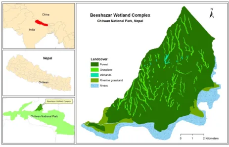
$ % Beeshazar Wetland Complex
%Chitwan National Park
% Close World Assumption
DNPWC-Department of National Parks and Wildlife Conservation
% Descriptive Ontology for Linguistic and Cognitive Engineering
&'&% , " ! (for example)
%Geographic Information System (s)
& & %' (that is)
$% Nepal Tourism Board
% Open World Assumption
Web Ontology Language
%Royal Chitwan National Park (former name of CNP)
(& )&% Square Kilometre
* %United Nations Educational, Scientific and Cultural Organization
viii $
Page
ACKNOWLEDGEMENTS iv
ABSTRACT v
KEYWORDS vi
ACRONYMS vii
INTEX OF TABLES xii
INDEX OF FIGURES xiii
+& *
1.1 Study background 1
1.2 Motivation 2
1.3 Research questions 2
1.4 Objectives 3
1.5 Research approach 3
1.6 Contribution 4
1.7 Thesis structure 4
,& *
-2.1.1 Commonsense spatial knowledge 5
2.1.2 Cognitive perspective 5
2.1.3 Computational perspective 7
2.2 Representation of geographic knowledge 8
2.2.1 Mathematical notion of geographic representation 8
2.2.2 Conceptual notion of geographic representation 9
2.3 Ontology 9
2.3.1 Origin and definition 10
2.3.2 Ontology of geospatial domain 11
2.3.3 Ontology grounding 12
2.3.4 Basic primitive of geospatial ontology 12
2.3.4.1 Geographic space 12
2.3.4.2 Spatiotemporal change 13
2.3.4.3 Basic theories of geospatial ontology 14
ix
2.3.5.1 Ontology language and standards 15
2.3.5.2 Logics and axioms 15
2.3.5.3 Ontology editors 16
.& / +0
3.1 Conceptual framework 17
3.2 Analytical Framework 18
3.2.1 Exploration of commonsense knowledge 18
3.2.1.1 The context of the knowledge 19
3.2.1.2 Source of information 19
3.2.2 Ontology development 20
1& $ * ,,
4.1.1 Study area 22
4.1.2 General Introduction 22
4.1.3 Physical and climatic environment 23
4.1.4 Biodiversity resources 23
4.2 Conservation narratives 23
4.2.1 Historical context 24
4.2.2 Emerging scenario 26
4.3 Spatial knowledge of non expert conservationist 27
4.3.1 Wildlife movement 27
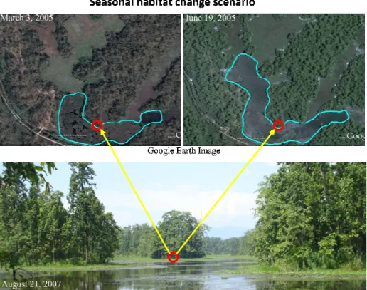
4.3.2 Habitat change 28
4.3.3 Spatial reasoning for conservation planning 30
-& * ..
5.1 Requirement for ontology 33
5.1.1 Motivation for building ontology 33
5.1.2 Scope of the ontology 33
5.1.3 Completeness and consistency questions 35
5.2 Source knowledge capture and knowledge glossary 35
5.2.1 Concept terms 35
5.2.2.1 Concept terms related to conservation 36
5.2.2.2 Concept terms related to geographic representation 37
5.2.2.3 Concept terms related to temporal representation 37
5.2.2.4 Concept terms related to saptio temporal change 38
5.2.2 Relationship terms 39
x
5.3.1 Open vs. close world assumption 40
5.3.2 Relationship rules 41
5.3.2.1 Functional 41
5.3.2.2 Transitive 41
5.3.2.3 Symmetry 42
5.3.2.4 Asymmetric 42
2& 1.
6.1 Terminology and relationship 43
6.1.1 OWL namespace and general convention 44
6.2 Building OWL classes 44
6.3 OWL properties 46
6.3.1 Property characteristics 46
6.3.2 Domain and range 47
6.4 Describing and defining classes 47
6.4.1 Property restriction 47
6.4.2 Necessary and sufficient condition 48
6.5 Ontology verification 49
6.6 Ontology documentation 50
0& * -+
7.1 OWL ontology evaluation 51
7.1.1 Requirements 51
7.1.2 Execution 52
7.1.3 Results 52
7.2 Limitation 55
3& * * * * -2
8.1 Summary 56
8.1.1 Commonsense spatial knowledge: An alternative grounding for geospatial
ontology 56
8.1.2 Ontology development: formal representation of commonsense knowledge 56
8.2 Conclusion 57
xi
BIBILIOGRAPHIC REFERENCE 60
APPENDICES 68
1. Some photograph during the field work 69
2. Concept term description related to conservation 70
3. Concept term description related to geographic representation 71
4. Concept terms description related to temporal representation 71
5. Concept terms description related to temporal representation 72
6. Relationship term description table 73
xii
INDEX OF TABLES
Page
Table 1: Steps for developing domain ontology 21
xiii
4 *
Page
Figure 1: Level of ontologies and their dependence 10
Figure 2: Conceptual framework of the study 17
Figure 3: Analytical framework of the study 18
Figure 4: Sketch map showing the community forest area in the buffer zone of CNP 20
Figure 5: Map of the study area 22
Figure 6: Rhino population in Chitwan National Park since 1950 25
Figure 7: Geographic representation of rhino movement 28
Figure 8: Conceptual representation habitat change scenario 29
Figure 8: Spatial representation of habitat change scenario 29
Figure 10: Elephant safari for rhino sightseeing in Chitwan National Park 31
Figure 11: Concept terms related to conservation phenomena 36
Figure 12: Concept terms of geographic representation 37
Figure 13: Concept terms of temporal representation 38
Figure 14: Concept terms of spatiotemporal change 38
Figure 15: Hierarchical and non hierarchical relationship between concepts 39
Figure 16: Terminology and relationship between logical and conceptual ontology 43
Figure 17: Class hierarchy of ‘Conservation GIS Ontology’ in Protégé 4.1 45
Figure 18: Object property ‘Conservation GIS Ontology’ in Protégé 4.1 46
Figure 19: Domain and range of property ‘has_Feature_Geometry’ 47
Figure 20: Description of a class ‘habitat’ by using property restriction’ 48
Figure 21: Necessary and sufficient condition for class ‘seasonal habitat change’ 49
Figure 22: Inserted and inferred class hierarchy 50
Figure 23: DL Query results 1 53
Figure 24: DL Query results 2 54
1
+&
*
+&+ #!56 7 8' ! 5
The development of spatial meaning in an environmental context requires an interpretation
of both physical and social components of the world as it is observed or perceived (Beck,
1967; Golledge, 2002). Knowledge about the physical environment acquired and used
without rigorous efforts are considered as the commonsense knowledge of space (Kuipers,
1978).Thinking about space and reasoning provides the basis for understanding spatial
pattern and behavior of the real world phenomena (Syfert, 2009). Geographic information is
meant to help people to understand the spatial, temporal and thematic attributes of the event
and process of the earth surface (Montello, 2009). However, the way real world phenomena
have been modeled and manipulated in GIS is contrary to peoples’ experience and
conceptualization of space (Freundschuh and Egenhofer, 1997).
Evolving technologies and online services are dramatically changing the ways of producing,
using, obtaining and sharing geographic information (Elwood, 2008). Ubiquity of geospatial
information can be seen in a variety of circumstances and essential in all aspect of the human
activities (Painho, 2007 a). Advances in location aware technologies, web mapping, and
wiki based collaboration have now outpaced the classical spatial data infrastructures as well
as widened the usage scenario around the world (Goodchild, 2007; Craglia et al. 2008;
Coleman, Georgiadou, and Labonte, 2009). Volunteer Geographic Information (VGI) and
‘crowdsourcing’ evolved around the world are some examples and collectively termed as
‘neo geography’ (Goodchild, 2009). One of the major challenges posed by new possibilities
arising from the interconnected world and increasing availability of geographic information
is to deal with interoperability of geospatial information (Fonseca, Câmara and Monterio,
2006).
The discourse of ontology in the geospatial domain has begun to deal with the
interoperability of geographic information. The use of ontologies for modeling geographic
information aims at capturing shared conceptualizations of specific user communities and
thus improves interoperability among different geographic databases (Smith and Mark,
1998). However, most of the conceptualization is concerned with the world view that is
modeled in existent data and the human perception of the world view is still missing. To
make the geographic information more useful and usable, ontology needs to address the
2 +&, # 9 #
Conservation planning is inherently spatial (Pressey et al. 2007) and biodiversity occurs at a
variety of geographic scales (Poiani et al., 2000). Knowledge required for biodiversity
conservation and conservation planning are fragmented (Hammond, Moritz and Agosti,
2008). Technical knowledge derived from systematic observations and experiments consists
of limited environmental facts. Integration of local knowledge using spatial framework can
complement the technical knowledge (Petch, Pauknerova and Heywood, 1995). However,
GIS applications still lack the mechanisms for the integration of spatial knowledge about
biodiversity resource obtained from multiple sources (Balram, Dragićević and Meredith,
2004).
The conservation field is not an exception from the growing availability of geographic
information. Furthermore, there exist inherent complexities such as vagueness,
spatiotemporal changes and processes of environmental phenomena. Paradigm shift of
conservation approaches from ‘classical’ to ‘neo populist’ has emphasized the community
based conservation practice. Peoples’ perception and commutative narratives have become
central towards the integrated conservation and development projects (Blaikie and
Jeanrenaud, 1997; Brown, 2002). In this regard, exploring the contextual meaning of the
geospatial information about conservation contributed by non expert users such as VGI and
crowedsourceing is an emerging challenge.
This research proposes a term ‘Conservation GIS Ontology’ that comprises the
conceptualization of spatial knowledge of non expert conservationists and conservation
narratives from Chitwan National Park, Nepal. The main motivation of this study is to enrich
the use of geographic information about conservation scenario contributed by non expert
conservationists. Consequently, growing availability of geographic can support for better
understanding of the environmental phenomena and their consequences on biodiversity
conservation.
+&. (! #
In consideration of the study background and motivation, this study will attempt to answer
the following research questions.
How can the use of ontology support the collection and conceptualization of
3
Are the considerations of spatiotemporal representation in the geospatial domain
enough to ground the dynamic conservation phenomena perceived by non expert
conservationists?
Is the formal knowledge representation language is adequate to support semantic
reasoning on human perception about conservation phenomena?
+&1 7: # 9
The main objective of this study is to conceptualize the commonsense spatial knowledge
about conservation. The specific objectives are:
Explore the spatial knowledge of non expert conservationists.
Design a conceptual ontology to conceptualize the commonsense knowledge about
conservation.
Build a logical ontology for the formal representation of commonsense knowledge to
describe conservation scenarios.
+&- ;;
The main foundation of this research is based on the argument that ‘model theoretic view of
semantics underlying in current ontology cannot account for the human conceptualization,
cognitive view of semantic is essential’ (Kuhn, 2004; Kuhn, 2005). With the consideration of
call for ontology grounding by (Kuhn, 2003), this study proposes for the anchoring of
geospatial ontology in commonsense knowledge and everyday experience. Explorations of
commonsense knowledge assimilate the notion of cognitive map (Tolman, 1948; Kuipers,
1978), image schemata (Jhonson, 1987; Kuhn, 2007), human spatial cognition (Mark, 1993),
perceptual space and cognitive space (Tversky, 1993; Montello, 1993).
The task of ontology development employed in this study combines the approaches of
designing conceptual ontology and constructing logical ontology (Kovacs et al., 2006;
Goodwin, 2007). Ontology engineering tasks is accomplished using Protégé 4.1 ontology
editor. Ontology evaluation is made based on the intrinsic evaluation approaches (Gómez
Pérez, 2004). Validation of the ontology with extrinsic approaches and inclusion of the
4
+&2 # 7!#
In contrast with the model theoretic semantic view underline in ontology, novelty of this
study is the elicitation of commonsense spatial knowledge about conservation scenario to
build geospatial ontology. Based on the outlined objectives and research approach, the major
contributions of this study are:
(i) The study provides a framework for exploring community narratives and
commonsense spatial knowledge to enrich the understanding about events and
processes of conservation (section 4);
(ii) An integrated approach to combine the human conceptualization of conservation
with geospatial ontology (section 5);
(iii) A domain ontology ‘Conservation GIS Ontology’ that comprises spatial
knowledge about conservation perceived by non expert conservationists (section
6, 7)
+&0 # ! #!
This study comprises eight chapters. The first chapter provides the research background,
motivation, objectives, research approach and major contribution areas of this study. The
second chapter presents the basic theoretical backgrounds that underlie this study. Relevant
studies and their theoretical and methodological discussions are summarized in terms of
commonsense spatial knowledge, geographic representation and ontology. The third chapter
describes research methods which are essential to fulfill the objectives of the study. The
fourth chapter highlights the context of the study through an overview of biophysical
environment, conservation narratives and the commonsense spatial knowledge about
conservation. Chapter five is about the development of the conceptual ontology and
comprises the conceptualization of conservation scenarios perceived by non expert
conservationists. Chapter six describes the methods for converting conceptual ontology into
logical ontology. A step by step process for authoring logical ontology in OWL using
Protégé 4.1 ontology editor is presented. Chapter seven comprises the evaluation of the
ontology and some limitations with respect to ontology engineering tasks. The last chapter of
this study provides an overall summary, conclusion and the future research work in this
5
,&
*
The literature review summarized in this section is primarily based on the theoretical and
methodological guidelines that are relevant for combining the multidisciplinary concepts
underlying in this study. This discussion is presented in three parts: commonsense
knowledge about space; representation of geographic information; and ontology.
,&+ )) ; # " 8 <" 5'
In simplest terms, commonsense knowledge indicates the collection of information or facts
that an ordinary person is expected to know. Encyclopedia1 defines commonsense
knowledge as ‘routine knowledge we have of our everyday attitudes’. Knowledge of space
represents the accumulation of facts about the spatial arrangement and interactions
comprising human environment relations and recognition of fundamental concepts. Such
knowledge is incidental and informally acquired during our everyday experience (Golledge,
2002). People’s perception of space, spatial cognition and spatial behavior are experience
based (Freundschuh and Egenhofer, 1997). Development of spatial knowledge is an
interpretation of the physical and social component of the world as they are observed or
perceived (Beck, 1967). The brain captures such state of experience and integrates them with
a multimodal representation stored in memory. When the knowledge is needed, instances of
multimodal representation are reactivated (Barsalou, 2008).
Study about commonsense knowledge extends over various disciplinary fields. The main
concern in this study is towards the human conceptualization of space and their
representation in the geospatial domain. Studies concerning commonsense spatial
knowledge are presented in two categories: ‘cognitive perspective’ and ‘computational
perspective’. The first category is related with the philosophical point of view to characterize
the commonsense knowledge. The second category is about their representation in computer
environment.
,&+&+ ' # 9 ; ; # 9
The basic concept underlying the process of spatial cognition was presented by Tolman
(1948) as cognitive map. Cognitive mapping is a psychological transformation process
through which people acquires, stores, recalls and decodes information about the relative
location and their attribute in everyday spatial environment (Downs and Seta, 1973).
6
Commonsense knowledge of space is an interesting domain of human knowledge (Kuipers,
1979). Kuipers (1978) characterized the important aspect of cognitive map using three
metaphors: ‘like a map in head’; ‘like a network’ and ‘like a catalog of routes’.
Mark (1993) discussed spatial knowledge in terms of ‘obvious’ and ‘subtle’ ways of human
spatial cognition. ‘Obvious’ way is about our everyday interaction with a wide range of
geographic concepts and features in real time. The ‘subtle’ is less obvious but provides great
spatial basic for many metaphors that helps us to understand more abstract and conceptual
domain. Furthermore, he grouped the geographic knowledge in three categories: declarative;
procedural and configurational. ‘Declarative’ geographic knowledge describes the facts
about the location. ‘Procedural’ geographic knowledge is about the ability of people to find
their ways from place to place and perform tasks. ‘Configurational’ describes the knowledge
of geographic space as ‘map like’ and often has or approximates a Euclidean geometry.
Mark and Smith (2001) have discussed the common sense world with the reference of
‘primary theory’ and ‘secondary theory’ presented by Horton (1982). Primary theory is that
part of common sense which exists in all cultures and in all human beings at all stage of
development. Secondary theories are the collection of folk beliefs which are characteristic of
different economic and social setting. Primary beliefs are related to the ‘mesoscopic
phenomena’ that are immediately accessible to perception and actions. Secondary beliefs are
related to the phenomena which are either too large or too small to be immediately accessible
to human beings in their everyday perceptions and actions. Meaningful structures for
organizing our experience, and the application of current knowledge of schemas to new
situations enables people to make sense, learn, and reason about our environment
(Freundschuh and Egenhofer, 1997).
Montello (1993) described that people’s perception of space and spatial behavior are scale
dependent and experience based which results in the difference in mental maps with others.
Tversky (1993) has made distinction between perceptual space and cognitive space with
respect to time and space. Perceptual space refers to what can be seen or observed through
the senses at one time where as cognitive spaces include larger scale spaces, which cannot be
captured immediately with our sensors and, therefore, must be subsequently put together in
order to be understood.
Cognitive research about space and place has identified several issues. Among them,
essential for understanding human spatial cognition are: the responses of sensory systems
7
adulthood; a people’s first exposure to a new place, the accuracy and precision of
knowledge; and cognitive structure and process (Montello and Freundschuh, 2005).
Jhonson (1987) has proposed a term ‘Image Schemata’ to describe the way people use the
recurring and imaginative patterns to understand and structure their experiences while
moving through and interacting with their environment. Kuhn (2007) has presented the key
characteristic of ‘Image schema’ (Johnson, 1987) and ‘image schematic categorization’
(Lakoff, 1987) as a theoretical foundation of cognitive semantics. Furthermore, he argues
that activities and process capture by ‘Image Schema’ and its support for understanding and
reasoning about experiences are potential for building the ontologies of spatio temporal
phenomena.
,&+&, );!# # " ; ; # 9
Computational aspect of commonsense spatial knowledge has emerged as the cognitive
research agenda of GIScience to investigate and address the questions surrounding digital
geographic information and GIS (Montello, 2009). Human cognition of space is not only
dependent on physical environment and time it is often fluid, flexible, and context
dependent. Therefore knowledge representation for computational environment should
reflect the situated nature of human understanding (Pike and Gahegan, 2007). Such
contextual and situated commonsense knowledge of real word in computational and artificial
intelligence perspectives is called naïve knowledge (Yi et al., 2008)
Egenhofer and Mark (1995) have presented the idea of ‘naive geography’ as a field of study
that is concerned with the formal model of the commonsense geographic world. The main
focus of the naïve geography is the area of spatial and temporal reasoning, representation in
various application domains and the way people use and interact with them. Formal model of
commonsense spatial knowledge also provides the basis to design intelligent GIS that can act
and respond the way people perform spatio temporal reasoning.
Harvey et al. (1999) raised the issue of semantic interoperability to navigate the meaning of
the different conceptualization and understanding of people and social groups exist in
geographic information technology. The transformation of commonsense spatial knowledge
from cognitive perspective to computational environment is one of the major challenges in
the contemporary GIS. The next section provides an overview of the existing efforts for
providing the representation model of the spatial knowledge in terms of geographic
8
,&, ; # # ' ' ; 8 <" 5'
Studies have provided several form of the conceptualization of geographic knowledge and
their representation model in GIS. However, there is lack of a comprehensive and widely
accepted conceptual model of the geographic space (Nunes, 1991). This section presents the
discussion about the representation of geographic knowledge in two parts: mathematical and
conceptual. Mathematical notion is related with the argument about the representation of
geographic information as vector and raster data model. The discussion towards the
perspective of ‘object vs. continuous field’ and ‘fiat and bona fide boundaries’ are
considered as conceptual representation.
,&,&+ # ) # " # ' ' ; ; # #
Although numerous definitions of geographic information and GIS can be found in the
literature, all focus on the concept of geo referencing (Goodchild, Yuan and Cova, 2007).
The traditional approach used in the design of geometric data models are based on the
Cartesian coordinate space. These models start from the mathematical basis of points in an
infinitely precise space and construct more meaningful concepts as sequences and enclosures
of connections of points (Freundschuh and Egenhofer, 1997). Vector and raster has provided
the representation model of geographic world during the past four decades (Goodchild, Yuan
and Cova, 2007).
Vector GIS is firmly rooted in the view of geography as spatial science, formulated in the
1950's and 60's, which resulted in the geometrization of the geographic world and its
reduction to a body of theories about relations between points, lines, polygons, and areas
(Couclelis, 1992). One of the problems with this view point is that euclidean points, lines,
and polygons do not exist in the natural, full scale geographic world. They are reasonable
approximations of geographic phenomena when modeled at specific scales (Freundschuh
and Egenhofer, 1997).
Another form of geographic representation in GIS is raster representation. In this
representation geographic world as a vector field of measurable values, discretized into pixel
array (Couclelis, 1992). This representation model has became popular among the uses
looked for by powerful analytical tools where generation of data was simple easy and cheap
(Nunes, 1991). Raster based GIS is strongly supported by the increasing importance of
satellite imagery not only in geography, but in wide areas of applied natural science
9
,&,&, ;#! " # ' ' ; ; # #
In terms of the conceptual notion of geographic representation, literatures are basically found
in two perspectives: ‘discrete object vs. continuous field’ and ‘fiat and bona fide boundaries’
Peuquet (1988) has pointed out the duality of discrete objects and continuous field as
distinction between location based and object based representation. Couclelis (1992) argued
that the field/object distinction is fundamental to our understanding of the world around us
and strongly related to human perception. Humans clearly perceive the world around them as
populated by discrete objects, to which they give names and ascribe behaviors (Goodchild,
Yuan and Cova, 2007). Egenhofer et al. (1999) brought this varied argument on object vs.
field representation as an issue of interoperability in GIS. As a solution, (Cova and
Goodchild, 2002) have proposed a hybrid concept in which every point in geographic space
mapped not to a value but to an entire discrete object.
Discourse on the geographic representation as ‘fiat’ and ‘bona fide’ boundary primarily
emerged with the realization to distinguish the geographic information represented in GIS in
terms of physical environment and social environment. In simple terms, ‘fiat’ boundaries are
defined by human beings and ‘bona fide’ boundaries are physical objects that exist in real the
world (Smith and Varzi, 2000). Smith (1995) argues that ‘bona fide’ and ‘fiat’ objects
represent the geographic world in two types of completely bounded objects. ‘Bona fide’
boundaries include physical realities such as riverbanks and coastlines; these would exist
even in the absence of all human efforts of delineation or conceptualization. On the other
hand, ‘fiat boundaries’, owe their existence to acts of human decision, administration, or fiat,
to laws or to political decrees. Political and administrative units, national and state borders,
and property boundaries are all examples of human created objects.
,&. # " '6
The word “ontology” has gained popularity within the knowledge engineering community.
However, its meaning tends to remain a bit vague, as the term is used very differently among
various disciplines (Guarino and Giaretta, 1995). This section presents some definition of
10
,&.&+ ' 5 5 #
Gruber (1993) has defined the ontology as:
“Ontology is an explicit specification of a conceptualization.”
The definition was made from the philosophical perspective where ontology is the
systematic account of existence. Guarino (1998) distinguished ontology in the philosophical
sense and in the context of Artificial Intelligence (AI). In the philosophical arena, ontology is
characterized as a particular system of categories for specific view of world. In AI, ontology
is an engineering artifact that describes a certain reality with a specific vocabulary using a set
of assumptions (Fonseca, Martin and Rodriguez, 2002). Smith (1998) describes ontology in
terms of reality base ontology(R Ontology) and epistemological ontology (E ontology). R
ontology is a theory about how the whole universe is organized, and corresponds to the
philosopher’s point of view. E ontology, on the other hand, fits the purposes of software
engineers and information scientists, and is defined as a theory about how a given individual,
group, language, or science conceptualizes a given domain. ontology is the study of the
categories of things that exists or may exist in some domain. Guarino (1998) describes
ontology as a logical theory accounting for the intended meaning of a formal vocabulary.
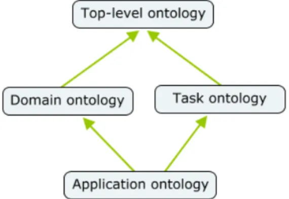
Furthermore, based on generality, he has proposed three levels of ontology: top level,
domain and task, and application. Top level ontology describes very general concepts such
as space, time, matter, object event, and action which are independent of a particular
problem. Domain ontology and task ontology describes the vocabulary related to a generic
domain or generic activity with its foundation on top level ontology. Application ontology
describes the concepts depending on particular domain task to perform certain activities.
Figure 1depicts the level of ontology and dependencies.
11
Based on the review of selected literature, Agarwal (2005) has pointed out the three primary
component of ontology: axioms, class or category, and relations. Axioms are used to model
conditions that are always true for domain. Category or class is a set of object and basis of
knowledge representation in ontology. Relations represent types of interactions between the
classes. Ontology aims at providing a consistent formal theory of tokens (instances) and
types (kind) of the real world and the relation and process that change them (Painho, 2007 b)
,&.&, # " '6 ' ; # " 5 )
With the advancement of GIS and GIS related applications on the World Wide Web and as
well as everyday activities, there is an ever increasing need to know how non experts
conceptualize the geographic domain (Mark and Smith, 2001). In such emerging scenario,
there are now many proposals for describing space, spatial relationships, and relations
between entities and their locations that have been developed within broadly ‘ontological’
frameworks (Bateman and Farrar, 2004). The purpose of using ontology in GIScience is to
define a common vocabulary that will allow interoperability and minimize any problems
with data integration, both from different systems and between user and system (Agarwal,
2005). The diversity of field covered in a geo ontology make GIS ontologically more
demanding than traditional systems (Frank, 2001). One of the main concerns of ontology in
the geospatial domain is to contribute for building better information systems (Kuhn, 2001).
Frank and Raubal (1999) have given emphasis on the formalization of spatial relation in
geographic space which is crucial for further advancement, standardization and
interoperability of GIS. Wang et al. (2007) argues that the consideration of theoretical basis
of geographic space can only make the spatial information model more semantic and
consistent. (Henriksson, Kauppinen, and Hyvönen, 2008) describes the geospatial ontology
correspond to the physical and social world having location on the surface on earthen and
their semantic and spatial relationship.
Arpinar et al. (2006) pointed out the importance of geospatial semantic for performing
spatial queries using imprecise spatial and temporal references (e.g. near , far , around noon )
for analyzing geospatial semantic associations using textual and other non metric
information. This can also help with effective geographical knowledge discovery. Several
elements are required when developing geospatial semantic that support effective spatial
reasoning. These include the use of qualitative modifiers, proxy place names, spatial
12
Geospatial information has radically changed in the past decades. Previously, geographic
information was collected, processed and analyzed in the context of the respective
community of a disciplinary field. Now information about geographic phenomena are
retrieved and combined in an ad hoc way from anywhere in the world and escaping their
local context (Kuhn, 2005). Such changes have lead to a number of challenges for dealing
with spatial information in the geospatial domain (Fonseca, Egenhofer and Davis, 2000)
,&.&. # " '6 ' ! 5 '
Consideration of ontology grounding in geospatial domain has emerged in the context that
the existent model theoretic view of semantic cannot account for human conceptualization
and hence cognitive semantic view of the real world is required (Kuhn, 2003). The main
argument of cognitive semantic is that language needs to be studied in the context of human
cognitive, ability and social setting which functions as means of communicating ideas such
as gestures, diagrams, procures, maps, mathematical symbols, computer program and so on
(Kuhn, 2004). Grounding gives meaning to ontological primitives by relating them to
qualities outside the symbol (Kuhn and Raubal, 2003). Cognitive semantic is more interested
in process (actions, events or other dynamic phenomena) and their role in producing
meaning than traditional linguistic and formal semantic (Kuhn, 2004).
,&.&1 $ ; ) # 9 ' ; # " # " '6
The main essence of this discussion is to provide an overview of the essential components of
geospatial ontology that makes the geographic information more meaningful among various
application domains. Several arguments have been made for describing geospatial ontology,
this section presents an overview in terms of geographic space and spatio temporal change.
,&.&1&+ ' ; ;
According to Spaccapietra, Cullot and Parent (2004), ontologies of space defines the
concepts that are used in specifying space, spatial elements (eg., point, line polygon), spatial
relationship. Fonseca, Câmara and Monterio (2006) proposed two basic concepts of geo
ontology: (a) concepts that correspond to physical phenomena in the real world; (b) concepts
that correspond to features of the world that we create to represent social and institutional
constructs. The first one is termed as ‘physical concepts’ and second one is ‘social concepts’.
Hierarchies of geo ontology comprise perspectives of conceptual representation of
13
‘fiat objects’. Frank (2001) has proposed that the components of geo ontology may be
categorized into five tiers. Tier 0, assumes an external reality consisting of a space time set
of continuous fields. Tier 1, is composed of the measurements of this reality by humans and
their instruments. Tier 2 consists of objects which are formed by humans based on
measurements. Tier 3 is the set of objects of social reality constructed by agreements and
contracts. The last one, Tier 4, is composed on subjective concepts about space.
,&.&1&, ; # %# ); " ; # !"
With the growing concern for addressing the event and process of real world phenomena,
emphasis of geospatial ontology is moving towards addressing spatiotemporal change.
Galton (2003) argues that ontologies in GIS must embrace a fully spatio temporal view of
the world which should include: spatial object and field; temporal object and field; and
location. The temporal analogies of objects are: events and process of various kinds.
Location may be both purely spatial location (regions, lines and points) and purely temporal
location (interval and instants). For full consideration of spatio temporal view, it is essential
to consider spatio temporal location.
A Descriptive Ontology for Linguistic and Cognitive Engineering (DOLCE) is a top level
ontology dealing with spatiotemporal particulars. The assumption made for DOLCE is that
different entities can be co located in the space time. Physical and non physical entities are
discussed as enduring and perduring entities (endurants and perdurants). The main difference
is associated with their behavior in time. Endurant are wholly present at any time they are
present. Perdurants are just extended in time by accumulating different temporal parts
(Masolo et al., 2002).
According to Grenon and Smith (2004) endurants are analogous to snapshots of reality and
perdurants are analogous to videos spanning time. Bittner and Smith (2002) has presented
the four dimensionalist ontology to describe the perspective of observation spanning the
whole reality from beginning to end and from one spatial extremity to the other. This theory
is divided into two major categories: ‘SNAP’ and ‘SPAN’. ‘SNAP’ ontology comprises
enduring entities such as substances, qualities, roles and functions. ‘SNAP’ entities are
related to space by locational relation and to time by a relation of existence at a time.
‘SPAN’ ontology comprises entities such as process and their parts. ‘SPAN’ entities are
subjected to spatio temporal and temporal locational relations (Bittner and Smith, 2002;
14
However, the ontology of geography domain is being elaborated by the corresponding
communities, spatio temporal ontologies are in their infancy. There is still a lack of
appropriate definition capable of dealing with space, time and suitable reasoning
(Spaccapietra, Cullot and Parent, 2004).
,&.&1&. $ # ' ; # " # " '6
Casati, Smith and Varzi (1998) have classified the theory of spatial representation for
describing the geospatial ontology into four main categories: regions of space; absolute vs.
relational theories of space; types of spatial entities; and boundaries and vagueness.
Furthermore, theoretical tools essential for developing theory of spatial representation are
described in terms of mereology, location and topology. Mereology is a first order theory
constructed around the primitive - . which involves a major part of our reasoning about space. Location describes the general theory of spatial location needed over and above
mereology in order to permit the investigation of the relation between a geographic entity
and the reason of space. Topology provides the semantic account of relation which goes
beyond the plain ‘part whole relation’. Bishr and Kuhn (2000) also pointed out the theories
essential for geospatial ontology as: theory of topology; theory of mereology; theory of
identity; theory of categories; and theories of dependence.
,&.&- # " '6 ' '
Ontological engineering encompasses a set of activities conducted during conceptualization,
design, implementation and deployment of ontologies (Mizoguchi, 1998; Devedzić, 2002).
The creation of ontology is s a knowledge acquisition task which involves eliciting,
analyzing and interpreting human expert knowledge, and transferring this knowledge into a
suitable representation (Mizen, Dolbear and Hart, 2005).
Ontologies are becoming increasingly popular in practice (Guarino and Welty, 2000). Until
now, several of ontologies have been developed by different groups, under different
approaches, and using different methods and techniques. However, a few works have been
published about how to proceed, showing the practices, design criteria, activities,
methodologies, and tools used to build them (Fernandez,Gomez Perez and Juristo, 1997).
One of the most important and critical questions when starting a new ontology is
15
basic essential elements that requires thorough understanding during ontology engineering
are: ontology language standards, ontology logics and ontology editors
,&.&-&+ # " '6 " '! ' 5 # 5 5
Ontology languages allow users to write explicit formal conceptualizations
of domains models (Antoniou and Harmelen, 2009). Several ontology languages have been
developed during the last few years and their foundation are basically on: Extensible Markup
Language (XML) syntax; Resource Description Framework (RDF) and RDF Schemas. XML
was designed to be a simple way to send documents across the ‘World Wide Web’. It allows
anyone to design their own document format and then write a document in it (Geroimenko,
2006). RDF defines a general common data model that adheres to web principles (W3C
2001). RDF schema allows a designer to define and publish the vocabulary used by an RDF
data model, i.e. define the data objects and their attributes (Gomez Perez and Corcho, 2002)
Web Ontology Language (OWL)2 is built on RDF and RDF Schema and aim to be the
standardized and broadly accepted ontology languages of the semantic web (Antoniou and
Harmelen, 2009). OWL consists of three languages: OWL Lite, OWL DL and OWL Full.
OWL DL was designed to support the existing Description Logic which has desirable
computational properties for reasoning systems3. OWL Lite is the simplest language and
OWL DL is a DL language with markup syntax. OWL Full has been developed to totally
include the semantic of the previous RDFS (RDF Schema) standard (Horrocks, 2005).
,&.&-&, ' 5 = )
Although several logics have been used in ontology language, description logics (DL) are
appearing as the leading formalism for the development of ontology (Spaccapietra, Cullot
and Parent, 2004). Description logics are a family of knowledge representation languages
that focus on describing the semantics of concepts, and using inference to automatically
classify new concepts in the concept hierarchy and to check non contradiction among
specifications (Horrocks, 2005). The basic inference on concept expressions in Description
Logics is subsumption (Nardi and Brachman, 2003).
DL languages vary in expressive power, depending on the building operators that are
retained for the language. In DL system, a knowledge base consists of a Terminology Box
2
http://www.w3.org/TR/owl ref/
16
(T Box) and Assertional Box (A Box).T Box describes conceptual knowledge terms of
concepts, roles and restriction and A Box holds the knowledge about the instances
(Spaccapietra, Cullot and Parent, 2004).
,&.&-&. # " '6 5 #
Ontology editors are tools that enable inspecting, browsing, codifying, and modifying
ontologies and support the ontology development and maintenance tasks. Existing editors
vary in the complexity of the underlying knowledge model, usability, scability, etc.
nevertheless, all of them provide enough support for the initial ontology development
(Stojanovic and Motik, 2002). Recently there are several ontology editors available for
authoring ontology4, one of them is Protégé Ontology Editor. Protégé is a free, open source
platform that provides a growing user community with a suite of tools to construct domain
models and knowledge based applications with ontology5.
4
http://www.xml.com/2002/11/06/Ontology_Editor_Survey.html
.&
/
This section comprises the
interpretation, analysis and di
objectives of the study.
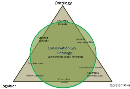
.&+ ;#! " ) < 8
The following conceptual fra
discussions (presented in sec
objectives of the study. The co
ontology, cognition and represe
Figur
Figure 2 depicts that ‘Cons
knowledge and has founda
representation and geospatia
conservation phenomena is
represented in this ontology. D
reference to the concepts of s
theoretical guidelines for explo
conservation phenomena as pe
focus is on the notion of cognit
conservation and their represe
17
s the conceptual and analytical framework that d
and discussion to respond to the research issue and to
< 8
al framework provides an overview about how the
in section 2) are aligned with the tasks essential to
The conceptual framework (Figure 2) comprises three co
representation.
Figure 2: Conceptual framework of the study
Conservation GIS Ontology’ is built upon commonsen
oundations in the concepts of spatial cognition, g
ospatial ontology. Commonsense spatial knowled
is the core component for describing the domain k
ogy. Discussion about commonsense knowledge is prese
ts of spatial cognition (section 2.1). These concepts p
ploring and managing the commonsense spatial knowle
as per the requirement of ontology development tasks.
cognitive semantic in the geospatial domain. Concepts re
epresentation as geographic information are fundamenta
hat directs the
nd to meet the
the theoretical
al to fulfill the
ree components:
onsense spatial
ion, geographic
owledge about
ain knowledge
s presented with
epts provide the
nowledge about
asks. The main
epts regarding to
formal representation of hum
Conceptual and methodologi
framework for the consideratio
GIS Ontology’.
.&, "6# " ) < 8
The analytical framework of
computational aspects of ontol
exploration of community narr
On the other hand, the compu
into natural language expressio
of the study is primarily based
and ontology development. T
summarized in figure 3.
Figu
.&,&+ =;" # ))
Commonsense spatial knowled
based on the field work carrie
inventory initiatives in Beesha
area map in Figure 5). Althou
interview and communication
enrich the information requir
development tasks. The contex
18
f human perception about conservation scenarios (sec
dological arguments about ontology (section 2.3) p
eration of commonsense spatial knowledge to design ‘Co
< 8
rk of this study is designed by combining the cogn
ontology development. The cognitive aspect is concerne
ty narratives and spatial knowledge of non expert conser
computational aspect deals with converting the domain k
pression and thereafter into a machine readable language
based on two tasks: exploration of commonsense spatial k
ent. The main processes and steps employed in this
Figure 3: Analytical framework of the study
)) 8 <" 5'
nowledge about conservation scenario presented in this
carried out as a part of the community based biodiversit
eeshazar Wetland Complex, Chitwan National Park, Ne
Although the field work was not intended for this study
cation with the local people and key informants is con
required to conceptualize the domain knowledge and
ontext and source of the commonsense knowledge are as f
s (section 2.2).
.3) provides a
n ‘Conservation
cognitive and
ncerned with the
conservationists.
main knowledge
guage. Analysis
atial knowledge
this study are
n this study are
iversity resource
rk, Nepal (study
s study purpose,
is conducted to
e and ontology
19 .&,&+&+ # =# # 8 <" 5'
Commonsense knowledge discussed in this study represents the conservation scenario of the
Chitwan National Park (now onwards referred as CNP) from the community knowledge
perspective. Such knowledge concerns only with the spatial information that makes sense to
be represented as geographic object or geographic information. For example, knowledge
about wildlife movement comprises of information about wildlife name, observed location
and observation time. Such commonsense spatial knowledge regarding to the conservation
scenario are broadly categorized as: wildlife, habitat, human activities, institution policy,
disaster, and natural environment. Descriptions of each category are provided with reference
to the knowledge of non expert conservationists and do not bear the complete list in the
context of scientific vocabulary or taxonomy.
.&,&+&, ! ) #
Non expert conservationists are the key informants of this study. Tourist guides, park
guards, community forest guards, members of local youth clubs and informal intuitions and
local people are considered as non expert conservationists. Human perception and spatial
knowledge about conservation scenario were explored during the ‘map reading’ training and
‘Community GIS’ training (some photographs of field work are provided in Appendix 1)
conducted to enhance the spatial thinking of local community to support the biodiversity
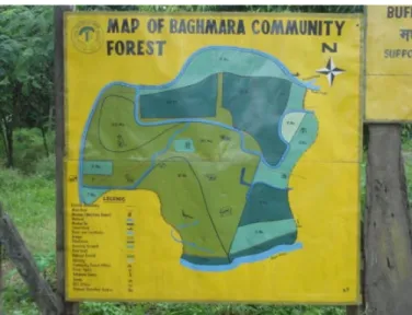
resource inventory. Some sketch maps displayed as tourist guide information were also
collected (Figure 4). Information depicted on such maps and community narratives to
describe wildlife movement, habitat change, human disturbance and environmental
phenomena was verified with reference to relevant literature, annual reports, Google Earth
images, aerial photographs and topographic map of the study area. Furthermore, historical
scenarios were collected through in depth interviews with the key informants such as
experienced tourist guides. Information related to biodiversity resources and some facts and
figures about the wildlife population were collect from the existing literature as well as
20
Figure 4: Sketch map showing the community forest area in the buffer zone of CNP
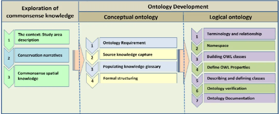
.&,&, # " '6 5 9 " ;) #
This section describes the step by step process for the formal representation of
commonsense knowledge about conservation. Ontology development task is primarily based
on the ontology development guidelines prepared by Ordinance Survey (Hemsley, 2003;
Kovacs et al., 2006; Hart and Goodwin, 2007; Goodwin, 2007), the ontology development
guidelines described in METHONTOLOGY ( Fernandez, Gomez Perez and Juristo, 1997)
and tutorial for authoring OWL Ontology using Protégé4.1 (Horridge et al., 2009).
METHONTOLOGY presents the set of activities that confirm the ontology development
process. This method discuss about life cycle of ontology development process to build
ontologies from scratch. Ontology development method comprises: specification; knowledge
acquisition; conceptualization; integration; implementation; and evaluation.
The methodology provided by Ordnance Survey comprises two phases for constructing
domain ontology: conceptual and logical ontology. Conceptual ontology is an organized way
of representing domain knowledge and it is written in natural language. On the other hand,
logical ontology contains the machine understandable descriptions about a specific domain
and provides the potential for data service interoperability (Kovacs et al., 2006). Major steps
21
# ; : # 8
1 Ontology requirement
specification
Formulated the completeness and consistency
questions
Define the scope and purpose of ontology
Ask for the completeness and consistency of key
objects
2 Source knowledge capture Note down the concept terms and relationship terms
of the domain knowledge
Collect the supplementary documentation that
satisfies the purpose and scope of the ontology
3 Populating knowledge
glossary
Provide the descriptive information of the concept
terms
Provide the meaning of concept and relationship
terms in natural language and
4 Formal structuring Open World vs. Closed World Reasoning
Relationship rules, relationship characteristics and
modifiers
Capturing loss of information
5 Evaluation and
Documentation
Conceptual ontology evaluation criteria
Documentation
22
1&
$ *
This section describes the commonsense spatial knowledge of conservation in the context of
Chitwan National Park (CNP), Nepal and discussion is presented in three parts. The first part
highlights the biophysical environment of the study area. The second part narrates
conservation practices with respect to historical context and emerging challenges. The third
part depicts the spatial knowledge of non expert conservationists regarding the conservation
scenario.
1&+ #!56
1&+&+ " # 5! #
CNP is situated in the central ‘Terai’ and ‘Siwalik’ region of Nepal. The CNP was
established in 1973 as the first National Park in Nepal. Currently it comprises 1682 sq km
(932 sq km as national park and 750 as buffer zone). In 1984, CNP scribed on the World
Heritage list under natural criteria VII, IX and X. In 2003, ‘Beeshazar and Associated Lakes’
of its buffer zone was designated as a Wetland of International Importance under the Ramsar
Convention (Bhuju et al/, 2007). CNP is administrated by the park management committee under the Department of National Parks and Wildlife Conservation (DNPWC) of the
Ministry of Forest and Soil Conservation6.
Figure 5: Map of the study area
23 1&+&, 6 " 5 " ) # 9 ) #
Chitwan National Park lies in the flood plains of the central Terai region of Nepal. The flood
plains are a series of ascending alluvial river terraces by Naryani River and its tributaries.
Climatic conditions are subtropical with a summer monsoon from mid June to late
September and a relatively dry winter from October to February. The monsoon rains cause
dramatic floods and alterations of river courses. Temperatures are highest, with a maximum
of 38°C, during summer, and drops to a minimum of 6°C, after the monsoon (Nakarmi,
2007; UNESCO, 2008).
1&+&. $ 5 9 #6 !
In the local language ‘Chitwan’ means ‘the forests where leopards dwell’ (NTB, 2009). This
indicates that CNP is rich in biodiversity resources. This area is one of the largest effective
protected areas in the lowlands of the Indian subcontinent; as such it is very important for
international conservation (UNESCO, 2008).CNP is home to many endangered and globally
threatened species. Nine hundred and nineteen species of flora are estimated in CNP. There
are more than 50 different grass species, including elephant grass. The park is home to 58
species of mammals, 539 species of birds, 56 species of reptiles and amphibians, and 124
species of fish. Some of the important mammals species are rhino (rhinoceros), tiger,
elephant, antelope and leopard. Major reptiles are crocodile, golden monitor lizard and
python. Bird species found in CNP include the Black necked stork, the Lesser adjutant stork,
Grey headed fishing eagle, Brahmini ducks, the Bengal florican and the Giant hornbill
(Bhuju et al/, 2007).
UNESCO7 describes the importance of the biodiversity of CNP as:
)' % ' % ! ! ' & ! %' '
"# , ' ' "" "/ ' " "# '
" / ' " " 0' ' "
' 1 %' ' " ' " ! ' 2 ! " ! /3
1&, 9 # # 9
The term ‘conservation narrative’ is used to characterise the conservation practice, its
consequence on biodiversity resource and response by local community in the context of
CNP. Referring to the explanation of conservation strategy by Brown (2002), the paradigm
24
shift of conservation practice in CNP can be characterised from ‘the classic approach’ (local
people as direct threat to biodiversity) to the ‘populist approach’ (participation and
empowerment of local people as a key to finding solutions to more sustainable use of
biodiversity) and recently towards the ‘neo liberal approach’ (adding economic value to
biodiversity such as ecotourism).
This section aims to depict the interplay between the natural environment and biodiversity
resources with the presence of human activities in the CNP. The main purpose for
describing the conservation narratives is to capture the knowledge about the spatial thinking
and reasoning made by local people and stakeholders in the context of changing socio
economic, environmental and conservation planning scenario over the last six decades.
Discussion is presented with reference to historical context and emerging scenario. Historical
context presents the response of the local community and stakeholders towards the several
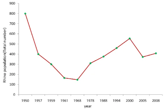
conservation practices with reference to the status of the rhino population since l950 (Figure
6). Emerging scenarios is about the requirements of spatial information system to understand
the historical and contemporary biophysical environment and their implication for local level
conservation planning.
1&,&+ / # " # =#
CNP has long been one of the country’s treasures of natural wonders. Historically, it is one
of the dense forest areas in the Nepal and known as )' 4 ' (' (the forest rich in wildlife).8 This forest area has been protected since at least 19th century as a hunting reserve
for Nepali and foreign aristocrats. During the period of 1846 1951, this area was protected
as a royal hunting reserve. It was estimated that the richness of biodiversity resource in this
area probably protected more animals than it killed. Because of the warm and temperate
climate this area was known as a malaria prone area and unsuitable for human settlement
(Gurung, 1983; UNESCO IUCN, 2003).
After massive malaria eradication programme in 1954 and resettlement provision of
government, huge tracts of the forest were cleared to make space for farmland. Because of
the excessive loss of habitat, the rhinoceros population declined dramatically during the
decade of 1950s (Gurung, 1983). Considering the potential threat to wildlife, the first
conservation effort had made through the establishment of Rhino sanctuary in 1957. In 1973,
this sanctuary was extended and a total of 932 sq.km. area were declared as Chitwan
8