CNR-IBAM C/da S.Loja Zona Industriale Tito Scalo (PZ) 85050, Italy
Received: 24 October 2009 – Revised: 3 January 2010 – Accepted: 2 February 2010 – Published: 16 March 2010
Abstract.This work, carried out with an integrated method-ological approach, focuses on the use of near surface geo-physics techniques, such as ground penetrating radar and electrical resistivity tomography (ERT), and geomorpholog-ical analysis, in order to reconstruct the cave distribution and geometry in a urban context and, in particular, in historical centres. The interaction during recent centuries between hu-man activity (caves excavation, birth and growth of an urban area) and the characters of the natural environment were the reasons of a progressive increase in hazard and vulnerability levels of several sites. The reconstruction of a detailed cave map distribution is the first step to define the anthropic and geomorphological hazard in urban areas, fundamental basis for planning and assessing the risk.
1 Introduction
This paper propose the use of near surface geophysics tech-niques, such as ground penetrating radar (GPR) and electri-cal resistivity tomography (ERT), in order to reconstruct an anthropic and/or natural cave system and its geometry in a ur-ban context and, in particular, in historical centres. The geo-physical methodological approach has been integrated with a geomorphological analysis finalized, to define the under-ground natural processes acting on study area.
There are a lot of historical Mediterranean sites founded on an original rupestrian settlement, of which often the new generations forgot the memory and new urban areas built on them covering any marks. The interaction during recent cen-turies between human activities (caves excavation, birth and growth of an urban area) and the characters of the natural
en-Correspondence to:M. Lazzari ([email protected] )
vironment were the reasons of a progressive increase in haz-ard and vulnerability levels of several sites. A fundamental basis for planning and assessing the risk in a such situation is the reconstruction of a detailed cave map distribution in or-der to define the anthropic and geomorphological hazard in urban areas.
The integrated near surface geophysics and geomorpho-logical techniques have been applied to the case study of Tursi hilltop town and its older part called Rabatana (Fig. 1), located in the south-western sector of the Basilicata (South-ern Italy). Rabatana represents an interesting example how the interaction between natural and man-made environments can induct such a precious cultural heritage. The history of this settlement has always been deeply connected with the characteristics of the neighbouring environment and it seems possible that the first settlement was built by excavating the slopes of the sandy relief. It was a typical rupestrian settle-ment, where meteoric water was stored inside underground tank (cisterns) excavated on the slopes (Lazzari et al., 2006). During recent centuries, the increase in territory development by humans produced an increase in cave excavation in the Tursi-Rabatana urban area. To recognize and reconstruct the extremely complex system of excavated tunnels in the sandy layers, a geophysical investigation has been carried out, in-tegrating the method of ERT (a multielectrode system with a Wenner-Schlumberger array layout) with the GPR (profiles were obtained using a SIR 2000-GSSI system equipped with two antennas of 400 and 200 MHz, connected by fibres-optic cables to the control unit) profiling.
Fig. 1.Geographical location of the study area and satellite image of Rabatana site.
Fig. 2. Geological map of the Tursi-Rabatana site (after Lazzari et al., 2006). Legend: (1) Landslides; (2) Alluvial deposits; (3) Grey-blue clays Formation; (4) Fluvial terraces; (5) Tursi Group (lower Pleistocene); (6) Pliocene deposits; (7) Varicolours clays Formation (Cretaceous-Oligocene); (8) Flysch of Serra Palazzo (Miocene); (9) built-up areas; (10) main faults; (11) main roads; (12) water source (perennial streams).
site is still characterized by a particular morphological his-tory and environmental factors that generate widespread risk conditions for the inhabitants and built-up areas (Lazzari et al., 2008).
2 Geological and geomorphological setting
The study area is located along the outer outcropping front of the southern Apennines thrust belt, exactly on the outer margin of the Plio-Pleistocene Sant’Arcangelo basin (Fig. 2) interpreted by several authors as the largest and most recent onshore piggyback basin (Caldara et al., 1988; Casero et al., 1988; Hippolyte, 1992; Hippolite et al., 1994). This basin was filled by huge volumes of synsedimentary (Hippolite et al., 1994; Zavala and Mutti, 1996) siliciclastic deposits
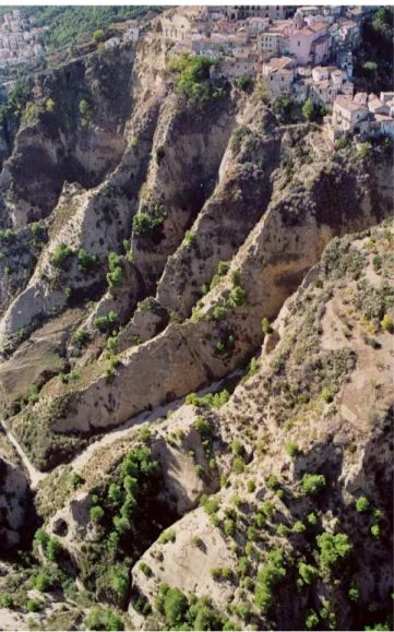
Fig. 3.Aerial view of Rabatana showing the deep gullies distributed around all the urban perimeter and due to intence erosional pro-cesses.
and threaten the conservation of these sites (Fig. 3). From the point of view of the process of physical degradation, the sandy facies are characterized by desiccation cracks to which the piping erosion and detachment blocks along the slopes are closely linked (Lazzari et al., 2006). In some cases large voids do not develop, but seepage erosion and running sand cause morphologically similar surface collapse phe-nomena (sinkholes). Outlets spreading can cause landslide phenomena (rockfall and toppling) along the steep sandy-clayey slopes (Fig. 4).
The secular multilevel cave excavation, developed along several fronts beneath the urban area, accelerated the pre-existing morphological processes acting on this site, favour-ing the water infiltration and subsurface erosional phenom-ena, characterized by widespread surface piping erosion of sandy bodies. Moreover, climate analysis carried out for the
Fig. 4. Western sector of Rabatana characterized by large voids and caves (black arrows show the entries) located under the urban settlement.
last century showed an increasing trend in rainfall intensity over short durations, which also induced an increase in haz-ard conditions of the slopes.
3 Hazard cave map reconstruction
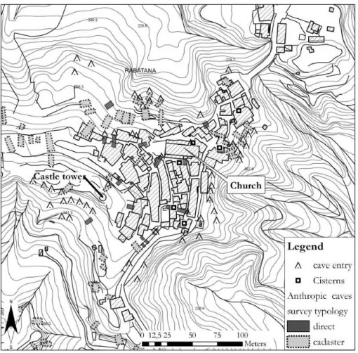
To analyze the anthropic hazard due to caves distribution, a cave map has been reconstructed (Fig. 5) through a field sur-vey preliminary approach and then using geophysical meth-ods.
Fig. 5.Distribution of caves surveyed in Rabatana historical centre.
3.1 Near surface geophysical approach
Two integrated geophysical methods of Electrical Resistiv-ity Tomography (ERT) with the GPR (Ground Penetrating Radar) profiling (Fig. 6) have been carried out in the Ra-batana historical site, in order to reconstruct the extremely complex near-surface hypogeal environment excavated in the sandy layers.
3.1.1 Electrical resistivity tomography technique
ERT is an active geoelectrical prospecting technique used to obtain 2-D, 3-D and 4-D (with time) images of the sub-surface electrical resistivity distribution. It has been applied for investigating areas of complex geology, such as volcanic and geothermal areas (Di Maio et al., 1998), seismotectonic structures (Caputo et al., 2003; Nguyen et al., 2005), and ar-eas affected by hydrogeologic phenomena and environmental problems (Ogilvy et al., 1999; Lapenna et al., 2005; Soupios et al., 2007; Georgaki et al., 2007; Naudet et al., 2008). It has been also used to locate cavities in the subsoil (El-Qady et al., 2005; Gibson et al., 2007; Crawford et al., 2007; Mitrofan et al., 2008; Soupios et al., 2008).
Fig. 6. Map of geophysical investigations carried out in historical centre of Rabatana site.
We applied this method in order to reconstruct the geolog-ical setting of the subsoil in the Rabatana site and to depict the geometric features of the cavities.
A georesistivitymeter Syscal R2, connected to a multi-electrode system characterized by 32 multi-electrodes and differ-ent electrode spacing, has been used in order to change the investigation depth and the spatial resolution.
The obtained tomographies are characterized by resistivity (ρ) values varying in the range 5–900m. The high resistiv-ity values (ρ>500m) are correlated with the presence of empty caves in the first layers of the subsoil. Low resistivity values (ρ<40m) can be associated with terrain character-ized by high water content.
In particular, the AA’ ERT crossing Vico Goldoni street (Fig. 7) has been performed by using a 2 m electrode spacing and reaching an investigation depth of about 10 m. It is char-acterized by a shallow resistive layer (about 2 m thick) with the presence of higher resistive cores (black circle in the fig-ure), associated with the existence of caves. One of these is well visible at about 22 m from the origin of the profile. The ERT also shows the presence of some conductive cores re-lated to zones of the subsoil characterized by water saturated sectors.
Different electrode spacing (3 m) have been used for BB’ and CC’ ERT profiles, in which a clear high contrast value between the cave zones (800–900m resistivity values) and deeper zones (5–10m resistivity values) have been also measured. This last condition produced RMS error values higher than AA’ ERT profile.
tion. The central and northern parts of the ERT highlight conductive material correlated with the presence of terrain characterized by high water content.
3.1.2 Ground penetrating radar technique
Ground penetrating radar (GPR) is an electromagnetic pulse reflection method based on physical principles similar to those of reflection seismics. It is a geophysical technique for shallow investigations with high resolution which has under-gone a rapid development during the last two decades (Blin-dow et al., 1987). There are several synonyms and acronyms for this method like EMR (electromagnetic reflection), SIR (subsurface interface radar), georadar, subsurface penetrating radar and soil radar.
The GPR has been used increasingly and accepted for ge-ological, engineering, environmental (Tsokas et al., 1999; Stampolidis et al., 2003; Loperte et al., 2004) and archae-ological science starting from the 1980s. In fact, it offers very high performances in terms of non invasivity, real time information and available spatial resolution thanks to the use of a easy and portable instrumentation able to perform mea-surements in an simple and fast way (Daniels, 1996; Lazzari et al., 2006).
The GPR works by emitting an electromagnetic (em) pulse, generated by a transmitter antenna, towards the sur-face of the ground or any other object, and records (thanks to the same antenna or another one that acts as a receiver) the amplitude and time delay of any secondary reflection coming from the subsurface structures that may represent anomalies in terms of conductivity (σ) and/or (dielectric) permittivity (ε) with respect to the host medium. The raw time-amplitude data (radargram) are usually displayed as a two-dimensional profile (B-scan) with theX-axis denoting the movement di-rection of the antenna and theY-axis representing the two-travel-time (proportional to the depth).
Fig. 8.Main representative radargrams carried out along Vico Goldoni (I) and M. Pagano (II) streets located at different topographic heights in Rabatana site.
Fig. 10. Representative scheme of the evolution of the morphological processes acting on Rabatana slopes and subsurface. In(a)the predisposing elements to landslide and collapse phenomena are shown. The following morphological phase is shown in(b)where the main morphological effect is linked to the slope movements and cave collapses (after Lazzari et al., 2006).
Owing to the presence of several obstacles (main an-thropization) within the village, here shows the main radar-gram acquired.
The survey was focused on three different roads. In total 50 GPR-profiles comprising more than 2.700 m of linear sur-vey were made, of these the most relevant radar sections will be shown.
The GPR data set was analysed using the REFLEX- Win Version 5.0.5 program (Sandmeier software). Profile pro-cessing included sequential zero-time corrections, running average filter, exponential gain function, band-pass filter and plotting.
In particular, the GPR-section, carried out along Vico Goldoni street which is totally 24 m long (Fig. 8I), is char-acterized by hyperbolic anomalies, associated with the pres-ence of caves, such as the one located between 7 m and 12 m from the origin of the profile. Furthermore, the lower part of GPR-section shows the presence of an absorbing area, proba-bly related to the presence of soil characterized by high water content.
The Vico M. Pagano street GPR section, which is totally 47 m long (Fig. 8II), shows various hyperbolic reflectors that occur throughout the radargram. The bottom part shows the presence of a very high absorbing zone corresponding to the conductive zone of geoelectric surveys.
The radar section (Fig. 9I and II) carried out along Duca Degli Abruzzi road is 72 m long. The first part (Fig. 9I) is characterized by two hyperbolic reflectors, respectively be-tween 6 and 10 m related to a very large cave unknown to the citizens, while in the central part there is an absorbing zone.
The second electromagnetic image (Fig. 9II) shows hyper-bolic reflectors associated with the presence of caves in the subsoil both in the first and in the second part.
4 Conclusions
The integrated analysis of geophysical techniques and geo-morphological field survey permitted to reconstruct a map of man made caves showing the interaction areas with historical buildings in which the collapse and sinkhole risk is higher. In particular, ERT furnished a further validation element to the morphoevolutive model proposed by Lazzari et al. (2006) for the Rabatana hilltop village (Fig. 10). In fact, observing all together the three ERTs (Fig. 7), carried out along pro-files parallel to each other at different heights, it is possi-ble to distinguish the geometrical development of the areas characterized by highest water content with two main con-ductive cores due to water seepage from the higher altitudes (where the sandy substratum outcrops directly and some ru-ins without roofs are also present) toward the lower, where wide moisture areas were generated along the outer slopes of Rabatana. In particular, it is well visible as the small conduc-tive cores characterizing the AA’ ERT increase their sizes in the BB’ ERT and decrease sizes where the water goes out, close to the area where the CC’ ERT has been performed.
Edited by: L. Eppelbaum, N. Masini, and F. Soldovieri Reviewed by: two anonymous referees
References
Blindow, N., Erzenginger, P., Pahls, H., Scholz, H., and Thyssen, F.: Continuous profiling of subsurface structures and groundwater surface by EMR methods in Southern Egypt. Berliner Geowiss. Abh. (A) 75.2, 575–627, 1987.
Caldara, M., Loiacono, F., Morlotti, E., Pieri, P., and Sabato, L.: I depositi pliopleistocenici della parte Nord del bacino di Sant’Arcangelo (Appennino lucano): caratteri geologici e pale-oambientali, Mem. Soc. Geol. It., 41, 391–410, 1988.
Caputo, R., Piscitelli, S., Oliveto, A., Rizzo, E., and Lapenna, V.: High-resolution resistivity tomographies in Active Tectonic stud-ies. Examples from the Tyrnavos Basin, Greece. J. Geodyn., 36, 19–35, 2003.
Crawford, N. C., Croft, L. A., Cesin, G. L., and Wilson, S.: Mi-crogravity and Electrical Resistivity Techniques for Detection of Caves and Clandestine Tunnels, American Geophysical Union, Fall Meeting 2007, abstract #NS21A-05, 2007.
Casero, P., Roure, F., Endignoux, L., Moretti, I., Muller, C., Sage, L., and Vially, R: Neogene geodynamic evolution of the southern Apennines, Mem. Soc. Geol. It., 41, 109–120, 1988.
Daniels, D. J.: Surface-penetrating Radar, Institution of Electrical Engineers Radar Series, ERA Technology, ISBN 0-85296-862, No. 6, London, UK, 1996.
Di Maio, R., Mauriello, P., Patella, D., Petrillo, Z., Piscitelli, S., and Siniscalchi, A.: Electric and electromagnetic outline of the Mount Somma–Vesuvius structural setting, J. Volcanol. Geotherm. Res., 82, 219–238, 1998.
El-Qady, G., Hafez, M., Abdalla, M., and Ushijima, K.,: Imaging subsurface cavities using geoelectric tomography and ground-penetrating radar, J. Cave Karst. Stud., 67(3), 174–181, 2005. Georgaki I., Soupios, P., Sakkas, N., Ververidis, P., Trandas, E.,
Vallianatos, F., and Manios T.: Evaluating the Use of Electri-cal Resistivity Imaging Technique For Improving CH4and CO2
Emission Rate Estimations in Landfills, Sci. Total Environ., 389, 522–531, 2007.
Gibson, P. J., Lyle, P., and George, D. M.: Application of resis-tivity and magnetometry geophysical techniques for near-surface investigations in karstic terranes in Ireland, J. Cave Karst. Stud., 66(2), 35–38, 2007.
Loke, M. H.: RES2DINV ver. 3.42, Geoelectrical Imaging 2-D & 3-D, User Manual, 1999.
Loke, M. H. and Barker, R. D.: Rapid least-squares inversion of apparent resistivity pseudosections by a quasi-Newton method, Geophys. Prospect., 44, 131–152, 1996.
Loperte, A., Cristallo, F., Lapenna, V., Bavusi, M., Piscitelli, S., and Rizzo, E.: GPR and Electrical tomography survey to detect cavities in the urban area of Matera (southern Italy). Progress in Electromagnetic Research Symposium, 28–31 March, Pisa, Italy, 2004.
Hippolyte J. C.: Tectonique de l’Apennin m´eridional: structures et pal´eocontraintes d’un prisme d’accr´etion continental, Unpubl. PhD. Thesis, Universit´e P. et M. Curies, Paris, 1992.
Hippolyte, J. C., Angelier, J., Roure, F., and Casero, P.: Piggyback basin development and thrust belt evolution: structural and pale-ostress analysis of Plio-Quaternary basin in the southern Apen-nines, J. Struct. Geol., 16, 159–173, 1994.
Mitrofan, H., Povara I., and Mafteiu, M.: Geoelectrical investiga-ˇ tions by means of resistivity methods in karst areas in Romania, Environ. Geol., 55(2), 405–413, doi:10.1007/s00254-007-0986-1, 2008.
Naudet, V., Lazzari, M., Perrone, A., Loperte, A., Piscitelli, S., and Lapenna, V.: Integrated geophysical and geomorphological ap-proach to investigate the snowmelt-triggered landslide of Bosco Piccolo village (Basilicata, southern Italy), Eng. Geol., 98, 156– 167, 2008.
Nguyen, F., Garambois, S., Jongmans, D., Pirard, E., and Locke, M.: Image processing of 2-D resistivity data to locate precisely faults, J. Appl. Geophys. 57, 260–277, 2005.
Ogilvy, R., Meldrum, P., and Chambers, J.: Imaging of industrial waste deposits and buried quarry geometry by 3-D resistivity to-mography, Eur. J. Environ. Eng. Geophys., 3, 103–113, 1999. Soupios, P., Papadopoulos, N., Papadopoulos, I., Kouli, M.,
Val-lianatos, F., Sarris, A., and Manios, T.: Application of Integrated Methods in Mapping Waste Disposal Areas, Environ. Geol., 53(3), 661–675, 2007.
Soupios, P., Loupasakis, C., and Vallianatos, F.: Reconstructing former urban environments by combining geophysical electrical methods and geotechnical engineering – an example from Cha-nia, Greece, J. Geophys. Eng., 186–194, 2008.