1Geoarte Consultoria Geológica e Artística Ltda. Belém (PA), Brasil. E-mail: [email protected]
*Corresponding author
Manuscrito ID: 30053. Submetido em: 05/11/2013. Aprovado em: 12/05/2014. ABSTRACT: Seismic data from Petrobras (Brazilian state-owned petroleum company) show wide deformation and many reverse faults throughout the Solimões and Acre basins of northern Brazil. his deformation was observed for the irst time in the Juruá River in 1976 in the Solimões Basin, and it increases toward Acre and Subandean basins from Argentine and Chile to Colombia and Venezuela. Structural inversions, block uplifts, and asymmetrical folds are attributed to compression and shearing stresses along this wide area. he severe diastrophism seen in the Juruá River area is of Late Jurassic (Kimmeridgian) age. It probably coincided with the inal separation between Laurasia and Gondwana continents and the initial opening of the Central Atlantic Ocean. In Peru and neighboring countries, the same Late Jurassic orogeny is also present. It occurs in the form of widespread regional uplifts, structural inversions, tilting, faults and asymmetrical folds beneath a pronounced regional parallel or angular unconformity of latest Jurassic age, marking a irst-order sequence boundary above the Upper Jurassic Sarayaquillo Formation and equivalent formations, as well as above older formations. he depositional hiatus at the upper part of the Jurassic System is attributed to reorganization of stress ields that resulted in basin inversions, followed by widespread peneplanation. he uppermost Jurassic or lower Cretaceous beds, deposited above this regional unconformity, were not afected by this tectonism in Brazilian and Subandean basins. he stratigraphy of Peruvian Subandean sedimentary basins is similar to that of the Acre Basin.
KEYWORDS: Juruá Orogeny; Late Jurassic; Kimmeridgian; North Brazil basins; Subandean basins.
RESUMO: Dados sísmicos da Petrobras (Companhia Brasileira Estatal de Petróleo) mostram ampla deformação e muitas falhas inversas ao longo das bacias do Solimões e do Acre no norte do Brasil. Esta deformação foi observada pela primeira vez no Rio Juruá em 1976 na Bacia do Solimões e aumenta para a Bacia do Acre e bacias subandinas desde a Argentina e Chile até Colômbia e Venezuela. Inversões estruturais, blocos soerguidos, dobras assimétricas são atribuídas à compressão e ao cisalhamento ao longo desta vasta área. O severo diastroismo tem idade neojurássica (kimmeridgiana) na área do Rio Juruá. Ele provavelmente é coincidente com a separação inal entre os continentes Laurásia e Gonduana e a abertura inicial do Oceano Atlântico Central. No Peru e em países vizinhos, a mesma orogenia neojurássica também está presente. Ela ocorre como soerguimentos regionais amplos, inversões estruturais, basculamentos, falhamentos e dobramentos assimétricos sob uma pronunciada discordância regional paralela ou angular de idade neojurássica, marcando um limite de sequência de primeira ordem acima da Formação Sarayaquillo e formações equivalentes de idade neojurássica, bem como acima de formações mais antigas. O hiato deposicional na parte superior do sistema Jurássico é atribuído à reorganização dos campos de esforços que resultou na inversão das bacias, seguido por peneplanação generalizada. As camadas do topo do Jurássico ou do Cretáceo Inferior, depositadas acima desta discordância regional, não foram afetadas por este tectonismo nas bacias brasileiras e subandinas. A estratigraia das bacias sedimentares subandinas peruanas é semelhante à da Bacia do Acre.
PALAVRAS-CHAVE: Orogenia Juruá; Neojurássico; Kimmeridgiano; bacias do norte do Brasil; bacias subandinas.
Juruá Orogeny:
Brazil and Andean Countries
Orogenia Juruá: Brasil e Países Andinos
Mario Vicente Caputo1*
InTRODUCTIOn
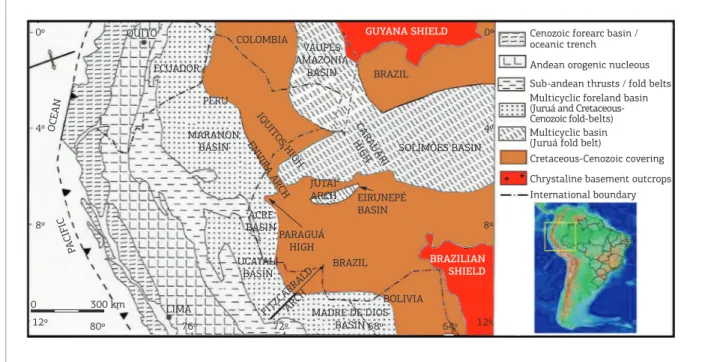
he Acre Basin, approximately 40,000 km2 in area, is
a small sedimentary basin located at the border with Peru and Bolivia. It is separated from the Peruvian Ucayali Basin on the western side by the Cenozoic basement-involved Divisor Reverses Fault (Serra do Divisor) and from the Solimões Basin on the eastern side by the Late Jurassic Envira Arch (Fig. 1). An E-trending Paraguá High, caused by the Juruá tectonism, divides the Acre Basin into the Jaquirana Trough in the north and the Central Trough in the south (Oliveira 1994).
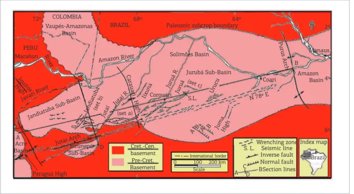
The Solimões Basin is bounded on the north by the Precambrian Guiana Shield and on the south by the Precambrian Brazilian Shield. he basin with approxi-mately 440,000 km2 in area is separated from the Marañon
(Peru) and Acre (Brazil) basins on its western margin by the Envira Arch (Caputo 2012b), and from the Amazon Basin in the east side by the Purus Arch (Fig. 2). An intra-basinal Carauari High separates the basin into a west-ern Jandiatuba Subbasin and an eastwest-ern Juruá Subbasin. Acre, Solimões, Madre de Dios, Ucayali, Marañon, and other Subandean basins originally formed a single major basin, that was later subdivided during various tectonic events. he transpressional faults and folds as old as the Late Jurassic constitute good hydrocarbon traps in Brazil
and in many Subandean basins. Plutonic and volcanic rocks of the same age are the best hosts for copper and gold ores in Chile (Vivallo & Henriquez 1998).
Previous studies of this structural framework and tecto-nism were carried out in Brazil by Szatmari (1981, 1983), Caputo (1985a, 1985b, 1991, 2012a), Porsche (1985), Mosmann et al. (1986), Campos and Teixeira (1988), Arana
et al. (1990), Oliveira (1994), Oliveira et al. (1995), and Zalán (1991, 2004). Barros and Carneiro (1991), Kennan and Pindell (2006), and Zelasco (2010) and many other investigators addressed speciic Subandean basins.
here is an apparent disagreement about the age of this Juruá orogenic event. Szatmari (1981, 1983) irst con-sidered the deformation of the Juruá River area as old as Middle Permian age, triggered by the Tardy–Hercynian Orogeny, and then he considered the Juruá tectonism, as old as Triassic age, related to the separation of North America from South America. Caputo (1985a, 1985b, 1991, 2012a) proposed a Late Jurassic age for this deformation in the ENE-trending Solimões–Acre basin tract; Campos and Teixeira (1988) attributed an Early Cretaceous age; Zalán (1991) and Barros and Carneiro (1991), who coined the terms Juruá Orogeny, used the same name, derived from the Juruá River area deformation, for a Triassic Orogeny in Peru. Oliveira (1994) and Oliveira et al. (1995) inter-preted the Juruá Orogeny as a Jurassic event, and Zalán
Cenozoic forearc basin / oceanic trench GUYANA SHIELD
BRAZIL COLOMBIA
VAUPES AMAZONIA
BASIN
IQUITOS HIGH ENVIRA ARCH
CARA UARI HIGH
FITZCARRALDARCH
PERU
MARANON BASIN
UCAYALI BASIN
LIMA 300 km
0
12º 80º 76º 72º 68º 64º 12º
8º 8º
4º 4º
0º 0º
SOLIMÕES BASIN
BRAZIL PARAGUÁ
HIGH JUTAÍ ARCH ACRE
BASIN
BOLIVIA MADRE DE DIOS
BASIN EIRUNEPÉ BASIN
BRAZILIAN SHIELD ECUADOR
QUITO
OCEAN
PACIFIC
Andean orogenic nucleous Sub-andean thrusts / fold belts
Multicyclic basin (Juruá fold belt) Multicyclic foreland basin (Juruá and Cretaceous-Cenozoic fold-belts)
Cretaceous-Cenozoic covering
Chrystaline basement outcrops International boundary
Figure 1. Tectonic geological map of westernmost South America. The Neogene Peruvian Iquitos High corresponds to a small bulge in the Solimões Basin that does not separate it from the Acre Basin. This separation is done by
(1991, 2004 p. 610) irst attributed a Late Permian-Early Triassic age and later an Early Cretaceous age (140 Ma). In the Peruvian geological literature, the Juruá Orogeny is also placed in many diferent stratigraphic positions (Kennan & Pindell 2006; Rosas et al. 2007). In other words, geological and geophysical reports show that there are four orogenic events in Peru – Late Permian, latest Permian – Triassic, Middle Jurassic, and Late Jurassic – all of them have been referred as the “Juruá Orogeny”. Kennan and Pindell (2006) addressed the problem of age and the relations of the “Juruá” shortening and they stated that the age and relations of “Juruá” shortening depends on real dating in Western Brazil.
he age miscorrelation of this tectonic event should be set. he main aim of this article is to date the Juruá Orogeny more precisely and to show its wide extent in western Brazil and Andean countries.
StRAtigRAPHy
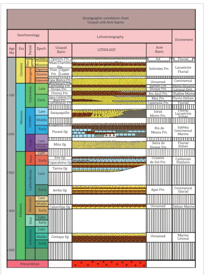
The Acre Sedimentary Basin is composed of a Phanerozoic stratigraphic section up to 6,000 m thick,
very similar to that of the Ucayali Basin of Peru, as observed in the Stratigraphic correlation chart (Fig. 3), but less complete. In the Acre Basin, Ordovician to Devonian formations are unknown because oil and gas exploration drillings have not penetrated the deepest basin depocen-ters, but seismic data indicate their presence.
he oldest section observed in outcrops and wells, the Apuí Formation (conglomerates, sandstones, thin shales, and diamictites), correlates with the Mississippian Ambo Group of Peru and Bolivia (Fig. 3). Above, the Lower Permian Cruzeiro do Sul Formation comprises the same lithotypes (limestones, shales, and fossils) as the upper part of the Copacabana Group of Peru and Bolivia. he upper-most part of the Cruzeiro do Sul Formation, composed of organic black shale and limestone beds, corresponds to the Ene Formation of Peru. he next section is a new unit named here as Serra do Divisor Formation, which consists of red and white sandstone beds as old as Late Permian to Early Triassic age. It is correlated with the Mitu Group of Subandean basins. he next section is the Rio do Moura Formation, composed of brown sandstone and sandy siltstone, gray and red shale, and thin limestone beds of Late Triassic to early Middle Jurassic age. It correlates
COLOMBIA
PERU
72º 68º 64º
2º
4º
6º C
D Vaupés-Amazonas
Basin
Acre Basin
A
Paraguá High
Eirunepé
Sub-Basin Cret.-Cen.basement International border
Wrenching zone Index map
Brazil Seismic line
Inverse fault Normal fault Section lines S. L.
A CD B Pre-Cret.
Basement Marañon Riv
er
Iquitos High
BRAZIL
Amazon River
Paleozoic subcrop boundary
Solimões Basin
Jurubá Sub-Basin Carauari High
S.L. Corouari
JumaHigh ABA B
Manaus
Amazon B
Coari
N 78º E Urucu
Juruá R. Juruá
(set c)
(set a) Iíxuna
Jutaí Jutaí R. Jandiatuba(set b)
Jandiatuba Sub-Basin
Jutaí Arch Javari Riv
er
Basin Purus Arch
0 100 200 km
Scale
LITHOLOGY Lithostratigraphy Stratigraphic correlation chart
Ucayali and Acre basins
Geochronology
Enviroment
Acre Basin
Içá
Solimões Fm
Unnamed Ramon Fm Divisor Fm Rio Azul Fm
Moa Fm Capanaua Fm
Juruá Mirim Fm.
Rio do Moura Fm.
Serra do Divisor Fm.
Cruzeiro do Sul Fm.
Apui Fm.
Unnamed
Unnamed
Fluvial
Lacustrine Fluvial
Continental Marine-Estuarine Littoral-Delt. Shallow Marine Fluvio-Deltaic
Fluvial
Fluvial Lacustrine
Eolian
Sabhka Continental
Marine
Fluvial Eolian
Carbonate Platform
Continental Glacial
Deltaic-Marine
Marine Littoral Ucayali
Basin Age
Ma
100
200
300
400
500
Era Epoch
Quat. Ypururo Fm.
Pebas/Chambira Fm. Pozo
Fm Upper Lower Pleist.
Pliocene Miocene Oligocene Eocene
PaleoceneCasa Blanca Fm Huchpayacu Fm Cachiyacu Fm Vivian Fm
Chonta Fm Agua Caliente Fm Cushabatay Fm
Sarayaquillo
Evaporite Unit
Pucará Gp
Mitu Gp
Ene Gp Copacabana Gp
Tarma Gp
Ambo Gp
Cabanillas Gp
Contaya Gp
Precambrian
Raya Fm Late
Early
Late
Late
Late
Late
Late
Late
Late Middle
Middle
Middle
Middle Early
Early
Early
Early
Early
Early
Early
Period
Neo- gene
Paleogene
Cenozoic
Mesozoic
Paleozoic
Ordo
vician
Silur.
Dev
onian
Carbonif
erous
Perm.
Cretaceous
Jurassic
Trias.
with the Pucará Formation of Peru. he upper part of the Pucará sequence is marked by evaporite sabkha deposits identiied in outcrops and in the subsurface by drilling and seismic data (Fernandez et al. 2002). he salt beds of the Upper Pucará Formation are named as the Evaporite Unit in Peru, but they are unnamed in Brazil. here are intrusive alkaline stocks connected to lacoliths, as old as 194 ± 12 Ma (Oliveira 1994) in the Rio do Moura Formation. he overlying Juruá Mirim Formation is a succession as old as the Middle to Late Jurassic time, composed of siltstone, red and brown shale, and red beds with a thick conglomerate on the top. his for-mation is believed to correlate with the Middle to Late Jurassic Sarayaquillo Formation of Peru. Two extrusive basic events were detected in the section. One of them, as old as 177 ± 8 Ma (Cunha 2007), was dated by K/Ar methodology in the Juruá Mirim Formation. he follow-ing section comprises clastics of the Capanaua, Moa, Rio Azul, Divisor, and Ramon formations as old as Aptian to Maastrichtian time. he Cretaceous Divisor Formation is not the same as the Permo–Triassic Serra do Divisor Formation. Peruvian Cretaceous Cushabatay, Agua Caliente, Chonta, Vivian, Cachiyacu, and Huchpayacu formations correlate with the Brazilian Cretaceous forma-tions (Fig. 3). It appears that many Cretaceous formaforma-tions have disconformable contacts in Brazil. he Cenozoic section consists of the Solimões and Içá formations. he Solimões unit is composed of principally red, green, and gray shale beds (Eocene?–Miocene), and the Içá unit con-sists of sandstone beds (Pleistocene). he Cenozoic units of the Ucayali Basin consist of the Casa Blanca, Pozo, Pebas, and Ypururo formations.
he stratigraphy of the Solimões Basin is similar to that of the Acre Basin, except for the absence of the Triassic – Jurassic section and small thickness. he Ordovician sec-tion shows continuity with the secsec-tion of the Vaupés – Amazonas Basin of Colombia (Fig. 1). In the Solimões Basin, lava lows are absent, but diabase dikes and sills as old as Late Triassic (~204 Ma) age are thick and abundant.
BASIn TECTOnICS
In western South America, the Latest Jurassic time was characterized by strong tectonism related to a change in the orientation of oceanic plate convergence, from nearly southwards to nearly northeastwards, expressed in a magmatic arc and tectonic deformation (Jaillard et al. 2000). his major plate kinematics reorganization cor-relates with important, global-scale, geodynamic changes in the Paciic Ocean and the westward propagation of the
Tethyan breakup of Laurasia and Gondwana during the initial opening of the Central Atlantic Ocean in the Late Jurassic time (Jaillard et al. 1995). Geological structures were formed coinciding with wide compression and shear-ing in west-north Brazil and Andean countries.
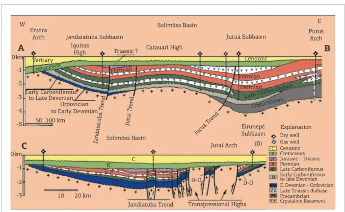
Brazilian Acre and Solimões basins were inverted in the Late Jurassic time, during the Kimmeridgian Stage (150 Ma), followed by extensive peneplanation before sub-sidence and deposition of Lower Cretaceous strata (Fig. 4), as observed in seismic lines and wells (Caputo 1991, 2012a; Oliveira 1994; Oliveira et al. 1995; Zalán 2004). hese events were followed by a noticeable diachro-nous marine and continental sedimentation in Subandean countries, from the latest Jurassic period onward. In Peru, a hiatus of approximately 20 M.y., between the top of the Middle Jurassic Pucará Formation and the overlying Early Cretaceous succession, resulted from regional uplift and peneplanation in the Contaya Arch in the Ucayali Basin (Zelasco 2010). he Shira Mountains, which divide the Andean Foreland into two depressions, the Pachitea Subbasin to the west and the Ucayali Basin to the east, are a prominent structural high in the area. Past recon-structions show that the Shira Mountains were an ances-tral horst block limited by major normal faults bounding half grabens of a Paleozoic rifting event (Alvarez 2007). he normal faults were reactivated by later compression. In a cross section, through the Shira Mountains, a large-scale deformation of pre-Cretaceous formations (Perupetro 2009) was observed and part of it is here attributed to the Juruá Orogeny. Overlying Early Cretaceous and Cenozoic rocks were later deformed during many Andean defor-mation phases.
In Argentine, Neuquén, Paganzo, Cuyo, and other basins were afected by widespread inversion, during the Auracan event. An angular unconformity is present in parts of Oxfordian and Kimmeridgian stages. Here the hiatus is approximately 5 M.y. he Late Jurassic age of the Juruá Orogeny, observed in the Solimões Basin and Andean countries, is also supported by the relations of magmatism, seismic surveys, structural interpretation, and sedimentary petrography in the mentioned basins.
MAgMATISM
In the past, based on the K/Ar method, the diabase intrusions of the Solimões Basin were considered as old as 150, 180, and 210 Ma., but 40Ar/39Ar dating provided
deined by tholeiitic basalts as old as 200 Ma., which crop out in the once-contiguous parts of North America, Europe, Africa, and South America (Marzoli et al. 1999). his Triassic–Jurassic transition magmatism is associated with the initial breakup of Pangea and the tectonic reac-tivation of the South American Platform.
In the Acre Basin, younger lava flows as old as 177 ± 8 Ma. (K/Ar) indicate an Early–Middle Jurassic age (Cunha 2007) for this magmatic extrusive event. Juruá reverse faults cut these basic igneous rocks in Acre and Solimões basins, as well as Middle to Upper Jurassic beds of the Juruá Mirim Formation in the Acre Basin, so this tectonism should be younger than the Middle Late Jurassic time and older than the Early Cretaceous time when a new deposition cycle started.
SEISMIC AnD
OUTCROppIng SURVEYS
he boundary between the pre-Andean system rocks (Ordovician to Jurassic) and the Andean system rocks (uppermost Jurassic to Cenozoic) is a regional uncon-formity that can be traced in seismic sections along all of the Subandean basins of Peru, Ecuador, Colombia,
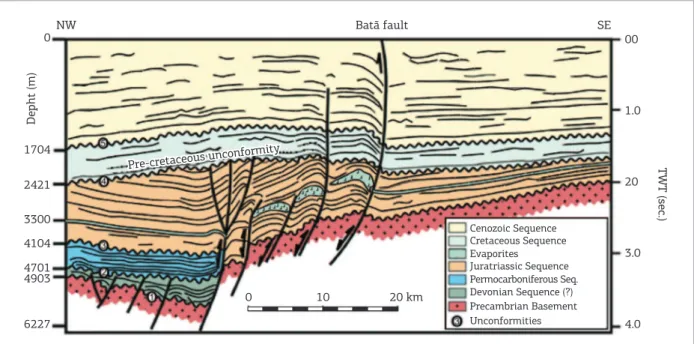
Venezuela, Bolivia, Argentine, and Chile, as well as in Brazil. Seismic lines in the Acre Basin show the Paleozoic – Jurassic sequence well deformed and separated by an angu-lar or parallel unconformity from nondeformed Early Cretaceous strata. he Juruá tectonism afected Middle to Early Late Jurassic strata, indicating a latest Jurassic age for the tectonism. A geological sketch (Fig. 5) of the seismic line 31-RL-183 (Fig. 2 from Zalán 2004), in the Acre Basin shows tectonic deformation of Upper Jurassic beds, made by the Juruá Orogeny before the Early Cretaceous sedimentation. In this igure, the Jurassic faults stop in the Jura–Triassic sequence. he Batã Fault and a parallel fault are related to the Andean Orogeny that reaches the Acre Basin.
he Contaya arch is an elongated geologic high that divides the Huallaga, Marañon, and Ucayali basins in the Peruvian Amazonian plain (Zelasco 2010). It seems to be normal fault-bounded blocks that were active in the Late Permian – Early Triassic time, during rifting and deposition of the Mitu Group. he Contaya High was reactivated by reverse faultings in the Late Jurassic and Cenozoic times. A lower Triassic unconformity, possibly linked to the breakup of Pangea and the opening of the North Atlantic Ocean, is also present in Zelasco’s seismic section interpretation. Flattening of the base-Cretaceous
Solimões Basin
Solimões Basin
T K
D-O
C C
P
D-O D-O
P-C
Jutaí Arch
Transpressional Highs Jandiatuba Trend
Eirunepé
Subbasin Dry wellExplanation
Gas well Cenozoic Cretaceous Jurassic - Triassic Permian Late Carboniferous Early Carboniferous to late Devonian
Late Triassic diabase Precambrian Crystaline Basement Jandaiatuba Subbasin
W Envira
Arch
Iquitos
High Triassic ? Carauari High
Juruá Subbasin
Cenozoic Tertiary
Early Carboniferous to Late Devonian
Ordovician to Early Devonian
Jandaiatuba T rend
Jutaí T rend
Juruá T rend
Cretaceous
Permian Permian
Permian
Late Carbonif erous
Precambrian
E
B
(D)
Purus Arch
A
C
0 km
0 km -1
-1 -2
-2 -3
-3 -4
-5 50 100 km
20 km 10
E. Devonian - Ordovician C
C
Pre-cretaceous unconformity
Batã fault
Pre-cretaceous unconformity
SE NW
0
1704
2421
3300
4104
4701 4903
6227 4.0
3.0 20 1.0
0 10 20 km
TWT (sec.)
Unconformities Precambrian Basement Devonian Sequence (?) Permocarboniferous Seq. Juratriassic Sequence Evaporites Cretaceous Sequence Cenozoic Sequence
Depht (m)
00
Figure 5. Seismic stratigraphic section of the Acre Basin. Old normal faults were reactivated as reverse faults in the Late Jurassic (Juruá Orogeny) and Cenozoic times (Andean Orogeny) (based on Zalán 2004).
unconformity in the Huallaga Basin (Peru) seismic lines (PARSEP 2001: Figs. 5, 9, and 20) shows the tectonic tilt-ing and the deformation of the Late Jurassic Sarayaquillo Formation below the Early Cretaceous angular uncon-formity. his Sarayaquillo deformation was caused by Late Jurassic stresses. In the Ene Basin of Peru, the base-Cretaceous unconformity overlies stratigraphic units of diferent ages, from Devonian to Late Jurassic (Perupetro S.A./PARSEP 2003), suggesting that the same Late Jurassic tectonism afected the basin. he same hap-pens in the seismic–stratigraphic section (Fig. 5) from the Acre Basin (Zalán 2004).
In the Santiago Basin (Peru), the Sarayaquillo Formation contains an internal erosional unconformity, but it is overlain by a large angular unconformity (Abanto 2003), correlated to the Juruá tectonism. In the Oriente Basin (Ecuador), the strongest deformation of the Late Jurassic Chapiza Formation below Cretaceous beds (Baby 2012), as observed in seismic lines, is present. The Chapiza Formation is equivalent to the Sarayaquillo Formation. In Colombia, large tectonism as old as Late Jurassic age was detected in the Middle Magdalena Valley and Vaupés – Amazonas basins under Cretaceous beds (Mendoza & Sanchez 2010). In Venezuela, the Jurassic System belongs to inverted Mesozoic grabens, located along the Mérida and Perijá Andes, where overlying transgressive basal beds of the Cretaceous frequently appear to be unconformable above the Jurassic La Quinta Formation, indicating oro-genic movements that occurred after the deposition of the
Jurassic La Quinta Formation (Hedberg 1942). In Bolivia, a tectonic event was attributed to the Kimmeridgian age (Late Jurassic) also observed in the Neuquén basin of Argentine and Chile (Sempere 1995). Evident correla-tion with Peru shows that this tectonism must be asso-ciated to the Late Jurassic Orogeny observed in Ucayali and Marañon basins (Sempere et al. 1999). In Argentine, this Kimmeridgian deformation is named as the Auracan phase or inversion, and in Peru, it is referred to as the Nevadan Orogeny, which was named in Sierra Nevada and Klamath mountains of Western North America; but it is better to use a South American regional name for the Late Jurassic Juruá Orogeny with its unique characteris-tics and large extent in western South America.
SEdimEntARy PEtRogRAPHy.
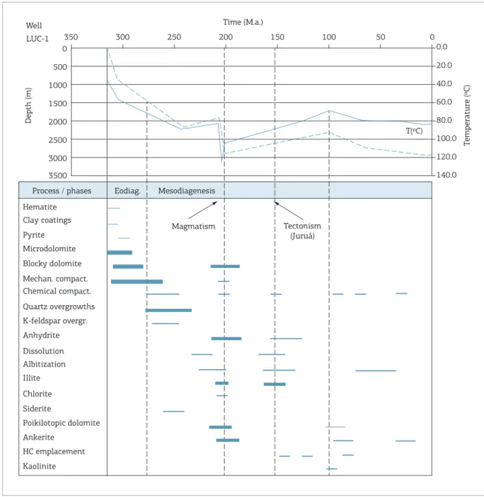
Figure 6. Burial and thermal history of the reservoirs from some oil ields of the Solimões Basin. Authigenic illite K/Ar ages of Carboniferous oil and gas reservoirs are related to the thermal efect of the voluminous latest Triassic basic magmatism (approximately 200 Ma), and to the Late Jurassic Juruá pervasive tectonism in Kimmeridgian time (approximately 150 Ma) (ater Elias et al. 2007).
0 50
Process / phases
Hematite
Magmatism Tectonism
(Juruá) Clay coatings
Pyrite Microdolomite Blocky dolomite Mechan. compact. Chemical compact. Quartz overgrowths K-feldspar overgr. Anhydrite Dissolution Albitization Illite Chlorite Siderite
Poikilotopic dolomite Ankerite
HC emplacement Kaolinite
Eodiag. Mesodiagenesis
Well Time (M.a.)
LUC-1
Depth (m)
0
500
1000
1500
2000
2500
3000
3500
100 150
200 250
300 350
20.0 0.0
40.0
60.0
80.0 T(ºC)
100.0
120.0
140.0
Temperature (ºC)
COnClUSIOnS
An overlooked strong Late Jurassic (Kimmeridgian) diastrophism is responsible for a generalized structural deformation observed in Solimões, Acre, and Subandean basins of western South America. he several ages for this orogeny proposed by the authors discussed in the text are not appropriate. hese authors were referring to gener-alized ages (Permian, Triassic, Jurassic, and Cretaceous)
for this orogeny that now have its dating reined as old as Kimmeridgian.
ACKnOWlEDgMEnTS
Abanto M.M.V. 2003. Evaluatión petrolífera de la Cuenca Santiago
MS Thesis, Facultad de Ingeniería Geológica, Minera, Metalúrgica y Geográica, Universidad Nacional Mayor de San Marcos, Lima, Peru, 172 p.
Alvarez J.O.S. 2007. Structural and stratigraphic evolution of Shira
Mountains, central Ucayali Basin, Perú. MS Thesis, Texas A&M University, Texas, 105 p.
Arana J., Della Giustina I.D., Vaz P.T., Barcelos C.A. 1990. Bacia do Acre, Arcabouço estrutural sísmico. Manaus. PETROBRAS/DENOC/ DINTER, internal report, 7 p.
Baby P. 2012. Estilos estructurales en sistemas de cuencas de
ante-país. Chapter IV. Available from: http://pt.scribd.com/doc/91699589/
Curso-Cuencas-de-Antepais. Accessed on 16.11.2013.
Barros M.C. & Carneiro E.P. 1991. The Triassic Juruá Orogeny and the tectono–sedimentary evolution of Peruvian Oriente Basin. Exploratory implications. In: Simpósio Bolivariano: Exploración Petrolera en las Cuencas Subandinas, Memórias, Bogotá, ACGGP, trabajo 6, 44 p. 4
Caputo M.V. 1985a. Origem do Alinhamento Estrutural do Juruá – Bacia do Solimões. In: SBG, 2º Simpósio de Geologia da Amazônia.
Anais, Belém, Pará., v 1, p. 242-258.
Caputo M.V. 1985b. Gênese do alinhamento estrutural do Juruá – Bacia do Solimões, Brasil. In: Simpósio Bolivariano sobre Exploracion
Petrolera en las Cuencas Subandinas. Asoc. Colombiana de Geologos y Geofísicos del Petroleo, Bogotá-Colombia, 1985, 16 p.
Caputo M.V. 1991. Solimões megashear: intraplate tectonics in
Northwestern Brazil. Geology, 19:246-249.
Caputo M.V. 2012a. Age of the Juruá Orogeny – Brazil and Peru.
In: 16° Congreso Peruano de Geologia and SEG Conference. SGP.
Sesion Geología Regional y Tectonica Andina. Expanded Abstract, SGPSEG009.pdf., 5 p., Lima, Peru.
Caputo M.V. 2012b. Arcos e tectônicas relacionadas às bacias do norte do Brasil. In: Congresso Brasileiro de Geologia, 46o, SBG,
Santos, Resumo [CD ROM].
Cunha P.R. da C. 2006. Bacias sedimentares Brasileiras – Bacia do Acre. Fundação Paleontológica Phoenix, 8(86):1-6.
Cunha P.R. da C. 2007. Bacia do Acre. Boletim de Geociências da Petrobras (Rio de Janeiro), 15(2):207-215.
Campos J.N.P. & Teixeira L.B. 1988. Estilos tectônicos da Bacia do Amazonas. In: 35º Congresso Brasileiro de Geologia, Belém, Sociedade Brasileira de Geologia, v. 5, p. 2161-2172.
Duarte K.S. 2011. Levantamentos exploratórios da ANP na Bacia do Acre. Revista Técnico-Cientíica da ANP, n. 1. Available from: https:// docs.google.com/file/d/0B8id850SAhQgYmI1YmIyMGMtZWM4N y00ZDhkLTgzYTUtZmRjYzYzNzMzOWEz/edit?hl=en_US&pli=1. Accessed on 03.02.2013.
Elias A.D., Ros L.F. de, Mizusaki A.M., Kawashita K. 2007. Isotopic evidence on the diagenetic evolution of coastal sabkha reservoirs
from the Solimões Basin, Northern Brazil. Gondwana Research, 11:
553–567.
Fernandez C.J., Martinez E., Calderon Y., Galdos C. 2002. The Pucará petroleum system and pre-Cretaceous sabkha regional seal, a
new hydrocarbon play in the Peruvian fold and thrust belt: In:
International Seminar INGEPET, 4, Lima, Peru, p. 12
Hedberg H.D. 1942. Mesozoic Stratigraphy of northern South America. Proceedings of Eighth American Scientiic Congress, USA, 1940, 4:195-227.
REFEREnCES
Jaillard E., Sempere T., Soler P., Carlier G., Marocco R. 1995. The role of Tethys in the evolution of northern Andes between Late Permian and Late Eocene times. The ocean basins and margins. In: Nairn A.E.M. et al. (eds.), The Tethys Ocean. Plenum Press, New York, vol. 8,
Ch 5a, p. 463-492.
Jaillard E., Hérail G., Monfret T., Díaz-Martínez E., Baby P., Lavenu A., Dumont J.F. 2000. Tectonic evolution of the Andes of Ecuador, Peru,
Bolivia and northernmost Chile. In: Cordani U.G., Milani E.J., Thomaz
Filho A., Campos, D.A. (eds.), Tectonic evolution of South America. 31st International Geological Congress, Rio de Janeiro, Brazil. p. 481-559.
Kennan L. & Pindell J. 2006. Exploration framework atlas series: Tectonic Analysis, Ltd. Vol. 3: The Central Andes. Incorporating: Southernmost Colombia, Ecuador, Peru, Bolivia, Northern Chile and Northern Argentina. Available from: http://www.tectonicanalysis. com. Accessed on 16.11.2013.
Kroonenberg S.B. & Reeves C.V. 2011. Geology and hydrocarbon potential – Vaupés and Amazonas basins. Geology and Hydrocarbon Potential – Regional Geology of Colombia. University EAFIT, Medellín, Colombia.
Marzoli A., Renne P.R., Piccirillo E.M., Ernesto M., Bellieni G., Min A. de. 1999. Extensive 200-million-year-old continent lood
basalts of the Central Atlantic magmatic province. Science,
284:616-618.
Mendoza M.F.V & Sanchez L.R.T. 2010. Cuencas sedimentarias en Colombia. Universidad Industrial de Santader – Escuela de Ingeniería de Petróleos. Ed., Mafe Vergara. Available from: http:// www.slideshare.net/macorca123/cuencas-sedimentarias-de-colombiadoc-1. Accessed on 16.11.2013.
Mosmann R., Falkenhein F.U.H., Gonçalves A., Nepomuceno Filho F.
1986. Oil potential of the Amazon paleozoic basins. In: Halbouty M.
(ed.), Future petroleum provinces of the world. AAPG Special volumes.
Memoir, 40:207-241.
Oliveira C.M.M. 1994. Estilos estruturais e evolução tectônica da
Bacia do Acre. Ouro Preto: MS Thesis, Escola de Minas, Departamento de Geologia, Universidade Federal de Ouro Preto, 206 p.
Oliveira C.M.M. de, Zalán P.V., Alkmin F.F. 1995. Tectonic evolution of the Acre Basin, Brazil. In: Simpósio Bolivariano, 6, Exploracion
petrolera en las cuencas Subandinas, Memórias, Tomo 1. Cartagena, Colombia, Trabajo 7, p. 46-65.
PARSEP 2001. The Huallaga basin and adjacent area. The hydrocarbon potential of NE Peru Huallaga, Santiago and Marañon Basin Study. Available from: http://www.perupetro.com.pe/ wps/wcm/connect/d12b9489-47f6-4f8c-b20e-c25b76efe165/ Huallaga%2BBasin%2BFinal%2BReport,%2BPerupetro%2B2001. pdf?MOD=AJPERE. Accessed on 18.11.2013.
Perupetro, 2009. Peruvian Ucayali Basin hydrocarbon potential. Available from: http://www.perupetro.com.pe/wps/wcm/connec t/6f269d804f9af3be8b6a8bf152a/03-Ucayali+Basin+Hydrocar bon+Potentialpdf?MOD=AJPERES&lmod=1289945638&CACHE ID=6f269d804f9af3be8b6a8bf15c7c1f2a&Ucayali. Accessed on 16.11.2013.
Perupetro S.A./PARSEP, 2003. Ucayali/Ene basin, summary, Peru, hydrocarbon evaluation. Available from: https://www.google.
com.br/#q=Per%C3%BApetro+S.A%2FParsep%2C+2003.+Ucay
-ali%2FEne+Basin%2C+Summary%2C+Per%C3%BA%2C+Hydrocar
-bon+Evaluation. Accessed on 16.11.2013.
Rosas S., Fontbote L., Tankard A. 2007. Tectonic evolution and paleogeography of the Mesozoic Pucará Basin, Central Peru. Journal of South American Earth Sciences, 24:1-24.
Sempere T. 1995. Phanerozoic evolution of Bolívia and adjacent regions. In: Tankard A.J., Suárez-Soruco R., Welsink H.J. (eds.),
Petroleum basins of South America. AAPG Memoir, 62:207-230.
Sempere T., Carlier G., Carlotto V., Jacay J., Rosas S., Soler P., Cardenas
J., Boudesseu N. 1999. Late Permian–Early-Early Mesozoic rits
in Peru and Bolivia and their bearing on Andean-age tectonics. Fourth/5AG, Goettingen (Germany), p. 680-685.
Szatmari P. 1981. Tectonismo herciniano – Andino e a Bacia Amazônica. Rio de Janeiro, Petrobras/Cenpes/Divex, internal report, 57 p.
Szatmari P. 1983. Amazon rit and Pisco-Juruá fault: their relations to
the separation of North America from Gondwana. Geology, 2:300-304.
Vivallo W. & Henriquez F. 1998. Génesis común de los depósitos estratoligados y vetiformes de cobre del Jurásico Medio a Superior en la Cordillera de la Costa, Región de Antofagasta, Chile. Revista Geológica de Chile, 25(2):199-228.
Wanderley Filho J.R., Melo J.H.G. de, Fonseca V.M.M. da, Machado D.M. da C. 2005. Bacia do Amazonas. Fundação Paleontológica Phoenix, 6(82):1-6.
Zalán, P.V. 1991. Inluence of Pre-Andean orogenies on the Paleozoic Intracratonic basins of South America. In: Simpósio Bolivariano:
Exploración Petrolera en las Cuencas Subandinas 4, Memórias, Bogotá, ACGGP, trabajo 7, 20 p.
Zalán P.V. 2004. Evolução Fanerozoica das bacias sedimentares Brasileiras. In: Mantesso-Neto V., Bartorelli A., Carneiro C. dal Ré.,
Brito-Neves B.B. (eds.), Geologia do Continente Sul-Americano –
evolução da obra de Fernando Flávio Marques de Almeida. São Paulo, Beca, Brazil. Cap. 33, p. 595-612.
Zelasco L.D.N. 2010. Tectonic evolution of the Contaya Arch,
Ucayali Basin, Peru, MS Thesis, Texas A&M University, Texas,
49 p.