(1) Parte da Tese de Mestrado, apresentada pelo primeiro autor, a Escola Superior de Agricultura “Luiz de Queiroz” – ESALQ/USP. Trabalho apresentado no XXIII Congresso Latinoamericano de Ciência do Solo, Águas de Lindóia (SP), 1996. Recebido para publicação em julho de 1998 e aprovado em maio de 2002.
(2) Professor do Departamento de Ciência do Solo da Escola Superior de Agricultura “Luiz de Queiroz” – ESALQ/USP. Caixa Pos-tal 09, CEP 13418-900 Piracicaba (SP). E-mail: [email protected]; [email protected]
(3) Professor Visitante do Departamento de Agronomia da Universidade Federal de Uberlândia – UFU. Caixa Postal 593, CEP 38400-902 Uberlândia (MG). E-mail: [email protected]
STRATIGRAPHICAL DISCONTINUITIES, TROPICAL
LANDSCAPE EVOLUTION AND SOIL DISTRIBUTION
RELATIONSHIPS IN A CASE STUDY IN SE-BRAZIL
(1)M. COOPER(2), P. VIDAL-TORRADO(2) & I. F. LEPSCH(3)
SUMMARY
On a regional summit surface in the county of Piracicaba (SP) within the Peripheric Depression of São Paulo, formed of discontinued flattened tops, there is an abrupt transition between a Typic Hapludox and a Kandiudalfic Eutrudox, together with two stoneline layers. Using stratigraphical, mineralogical, and cartographic studies, this transition and the soil distribution of this surface were studied, correlating them with the different parent materials and the morphoclimatic model of landscape evolution in Southeastern Brazil. The Typic Hapludox was formed on a sandy Cenozoic deposit (Q) that overlies a pellitic deposit of the Iratí formation (Pi), representing a regional erosive discordance. Westwards to the Piracicaba River, this sequence is interrupted by a diabase sill overlain by a red clayey material which gave origin to the Kandiudalfic Eutrudox. Two post-Permian depositional events were identified by the two stonelines and stratigraphical discontinuities. The first event generated the deposition of a sandy sediment in the form of levelled alveoluses on regional barriers, most of these formed by dikes and diabase sills, probably during a drier phase. The second depositional event, leading to the deposition of the red clay was probably the dissection of the previously formed pediplane during a humid climate, followed by another pedimentation process during a later, drier period.
Index terms: soil geomorphology, stonelines, Ti/Zr, Quaternary.
RESUMO: RELAÇÕES ENTRE DESCONTINUIDADES ESTRATIGRÁFICAS, MODELO DE EVOLUÇÃO DA PAISAGEM TROPICAL E A DISTRIBUIÇÃO DOS SOLOS EM UM ESTUDO DE CASO NO SUDESTE DO BRASIL
Numa superfície de cimeira regional, constituída de topos aplainados descontínuos e localizada no município de Piracicaba (SP), dentro da Depressão Periférica Paulista, um Latossolo Vermelho-Amarelo distrófico típico textura média álico transaciona abruptamente para um Nitossolo Vermelho eutroférrico latossólico, com presença de dois níveis de linhas de pedras. Por meio de estudos estratigráficos, mineralógicos e cartográficos, procurou-se entender esta transição, assim como a distribuição dos solos nessa superfície, correlacionando-os com os diferentes materiais de origem e com o modelo morfoclimático de evolução da paisagem no Brasil Sudeste. Constatou-se que o Latossolo Vermelho-Amarelo distrófico típico textura média álico é derivado de um depósito Cenozóico arenoso (Q), que, por sua vez, está assentado, em discordância erosiva regional, sobre um depósito pelítico da formação Irati (Pi). Esta seqüência é interrompida, em direção ao rio Piracicaba a oeste, por um sill de diabásio recoberto por um material vermelho e argiloso que dá origem ao Nitossolo Vermelho eutroférrico latossólico. Dois eventos deposicionais pós-permianos foram identificados pela presença de duas linhas de pedras e de descontinuidades estratigráficas. O primeiro evento corresponde à deposição do sedimento arenoso na forma de alvéolos escalonados em soleiras regionais, a maioria destas, formadas por diques e sills de diabásio, durante uma longa fase mais seca. Um segundo evento depositou o material argiloso vermelho, provavelmente após uma incisão, durante uma fase úmida, do pediplano formado anteriormente, seguido por outro processo de pedimentação durante um período seco posterior.
Termos de indexação: relações solo-geomorfologia-estratigrafia, linhas de pedras, relações Ti/Zr, geomorfologia do quaternário.
INTRODUCTION
Interpretation of the landscape evolution in eastern Brazil during the Quaternary has given rise to a controversy about the effect of the climatic changes of this period on the present tropical landscape features. This is because the intense pedogenesis of the humid tropical environment tends to mask the evidences of morphogenetic changes during alternating of semi-arid and humid climates, thus reducing the probability of a reasonable interpretation of the paleo-environments and the landscape evolution. Several authors that have studied the southeastern region of Brazil interpreted the landscape as a result of global climate shifts during the Tertiary and Quaternary (Bigarella & Andrade, 1965; Melo & Ponçano, 1983; Vidal-Torrado & Lepsch, 1993; Vidal-Torrado 1994). This relation between landscape evolution in the tropics and sub-tropics and climatic changes was also noted by Walker (1962) in southeastern Australia, Tardy (1986) in Africa and Absy et al. (1991) in the Brazilian Amazon. Assuming that some of these climatic changes left relict forms and vestiges in the landscape, made the understanding of tropical soil-landscape relations more difficult, particularly when compared to the lower and higher latitudes that were obliterated by the glaciers.
High flat summits, terraces, colluvia, stonelines and paleosols have been used as indicators to establish the relations between global climate changes and the landscape evolution of tropical America (Bigarella & Andrade, 1965; Melo & Ponçano, 1983; Torrado & Lepsch, 1993; Vidal-Torrado & Lepsch, 1998). The works of Penteado (1968) and Ab’Saber (1969) have been important for the understanding of the Peripheric Depression of São Paulo, a geomorphologic formation located in the Paraná river basin that corresponds to a depressed erosive area between the arenitic-basaltic cuestas towards the west and the Atlantic Crystalline Plateau. The origin of this depression has been interpreted as a result of differential erosion between sedimentary rocks and the crystalline rocks and basalts, caused by the consequent drainage and its subsequent tributaries (Penteado, 1968; Melo & Ponçano, 1983). It evolved during a time span of approximately 40 million years, between the formation of the Japi surface (Eocenic) and the deposition of the Rio Claro formation at the beginning of the Pleistocene.
the geomorphological evolution of the Peripheric Depression. As representative aspects of this heterogeneity we can cite abrupt lateral transitions between sandy and clayey soils, strong differences between adjacent soils in terms of mineralogical and chemical properties, and some stratigraphic features like the presence of stonelines at different levels in soil profiles.
To facilitate future soil surveys and with the objective of understanding the causes of the soil distribution heterogeneity in this region better, the landscape evolution and its relation to the soil parent material were studied. Therefore, a study area that presented some of the features mentioned above was chosen. The purpose was to correlate field evidences and stratigraphic studies with the landscape’s evolution.
MATERIALS AND METHODS
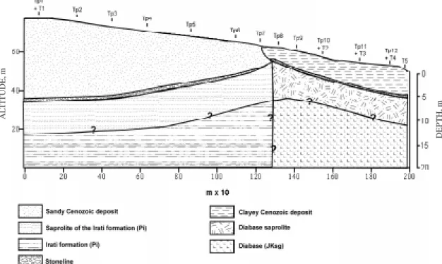
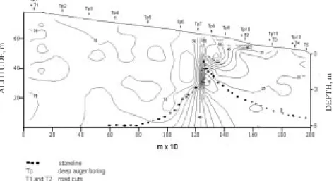
A transect located in the Piracicaba campus of the University of São Paulo, São Paulo State, Brazil was selected as subject, and its summit, shoulder and backslope segments were studied (Ruhe, 1960). The soils found in the transect were formed from different parent materials such as sandy Cenozoic deposits, possibly belonging to the Rio Claro formation underlaid by the lower Permian sediments that correspond to the Iratí formation made up of siltstones and claystones. This stratigraphy is
interrupted by a diabase intrusion in the form of a sill, which is related to the Serra Geral formation of the Jurassic/Cretaceous period. A Cenozoic red clayey deposit was observed covering the sill and part of the Iratí formation found at a higher position westward of the sequence at the point of contact with the sill (Figure 1).
Three hand-excavated pits (T3, T4 and T5), two road cuts (T1 and T2), and deep auger borings (6-7 m) (Tp1 to Tp12) were used to study the stratigraphy and soils and to detect lithological discontinuities (Figure 1). The soils were described and sampled according to standard methods (Lemos & Santos, 1984) and classified according to both the Brazilian soil classification system (EMBRAPA, 1999) and soil taxonomy (Soil Survey Staff, 1997). Three soil classes were identified: Latossolo Vermelho-Amarelo distrófico típico textura média álico (Typic Hapludox), Nitossolo Vermelho eutroférrico latossólico (Kandiudalfic Eutrudox), and a Nitossolo Vermelho eutroférrico típico (Kandiudalfic Eutrudox).
Particle size distribution of these samples was determined by sieving and by the Bouyocos method, using a densimeter, after dispersion with a sodium hydroxide and sodium hexametaphosphate solution (Camargo et al., 1986). The following sand fractions were separated: very coarse sand (-1 to 0 phi), coarse sand (0-1 phi), medium sand (1-2 phi), fine sand (2-3 phi) and very fine sand ((2-3-4,(2-3 phi). These values are given by:
phi = -log2 d
Figure 1. Soil and parent material distribution on the toposequence (T= road cuts and pits, Tp= deep auger borings).
AL
TITUDE,
m
where d is the particle diameter in milimeters. The results of this fractioning were evaluated visually by means of bar graphs (histograms) with a log-arithmetic scale, using the PHI program (van Lier & Vidal-Torrado, 1992). Interpolation graphs of the sand fraction were calculated using geostatistical gridding methods (Krigging) with the information extracted from all the sampling points.
Mineralogy and morphoscopy of coarse fractions was observed in undisturbed and oriented samples collected for the preparation of thin sections according to standard procedures (Castro, 1985). Elemental analyses of zirconium, titanium and iron were determined by X-ray fluorescence technique with energy dispersion using the Spectrace 5000 system. Quartz determinations were obtained by X-ray diffraction using a method adapted from Johnson & Beavers (1959).
RESULTS AND DISCUSSION
The observation of two stonelines at different depths and positions and of an abrupt lateral transition between a sandy and a clayey material (Figure 1) led to the identification of two depositional events. One would correspond to the sandy Cenozoic deposit that is correlated with the Rio Claro formation (Penteado, 1968; Melo & Ponçano,1983), and the other corresponds to a later event in which a red clayey material was deposited westward of the sill, towards the Piracicaba river, covering part of the Irati sediments and the diabase sill.
First depositional event
Morphological studies of a road cut (T1), located at km 30 of the “Luiz de Queiroz” highway connecting Piracicaba (SP) to Campinas (SP) together with information obtained from deep auger borings, showed the presence of a stoneline at the contact between the sandy superficial deposit and the Iratí formation at a depth of approximately 8 m (Figure 1). This stoneline consists of rounded quartzite pebbles with sizes varying from 1 to 8 cm in diameter, probably originated from the conglomeratic sandstones of the Piramboia formation as will be explained further ahead. Its conformation, mineralogy and shape suggest an allochthonous origin deposited during a semi-arid climate by erosion processes. The desert pavement thus formed and later covered by finer sediments is the evidence of a lithological discontinuity (Ruhe, 1959; Tricart & Cailleaux, 1965; Ab’saber, 1969; Riquier, 1969; Stoops, 1989; Lichte, 1990).
A few hundred meters from the studied road cut and at a similar altitude there is an outcropping of Higher Permian pellitic rocks (Corumbatai formation-Pc). In tectonically stable areas, the Pc rocks overlie the Middle Permian limestone and
pellitic sediments of the Iratí formation (Pi). Therefore, the occurrence of Pi and Pc formations side by side at a relatively short distance is probably the result of the reactivation of old faults causing the vertical dislocation of blocks. These faults could have been reactivated during the Higher Permian when the Pitanga dome was lifted (Melo, 1995).
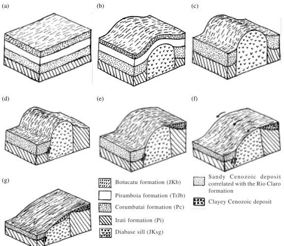
At the end of the Jurassic period occurred a three phase event called Wealdenian Reactivation (IPT, 1981). During the first phase, from the end of the Jurassic to the lower Cretaceous period, magmatic processes produced the great basaltic spills of the Serra Geral formation (Figures 2a and 2b). These were lodged in faults and fractures that occurred during the elevation of the Pitanga dome. This was probably the origin of the diabase sill found at the study site. A second phase was characterized by the end of the vulcanism and the attenuation of the tectonic processes that took place at the end of the lower Cretaceous and Eocene period. The last phase occurred during the rest of the Cenozoic era.
During the Oligocene, until the lower Miocene, neo-tectonic activity took place in old faults of the Peripheric Depression of São Paulo (IPT, 1981; Melo & Ponçano, 1983) (Figure 2d). This reactivation of faults could have led to the elevation and lowering of the stratigraphic deposits forming stratigraphic discordances within short distances.
The excavation processes of the Peripheric Depression of São Paulo (Figure 2c) was synchronous with to the tectonic reactivation that was taking place during the Oligocene. Mechanical morphoge-netic processes with pronounced pediplanation, probably under semi-arid climates, alternating with the incision of valleys and lowering of the local base level during humid climates (Bigarella & Andrade, 1965; Melo & Ponçano, 1983) resulted in the lowering and erosion of the stratigraphic deposits, thus exposing the most resistant materials, such as the diabase sills and dikes, forming regional tectonic barriers (Penteado, 1968; Melo & Ponçano, 1983; Melo, 1995).
Figure 2. Stratigraphic and landscape evolution of the region in which the study area is situated. (a) Hypothetical stratigraphy and landscape before the intrusion of the sill (Jurassic-Triassic); (b) Intrusion of the sill in faults and fractures formed during the higher Permian deforming the sedimentary strata; (c) Excavation of the Peripheric Depression exposing the diabase sill forming the tectonic barriers (between the Oligocene and Pliocene), (d) Reactivation of old faults during the Peripheric Depression formation lifting the diabase sill and the Irati formation and lowering the Corumbataí formation; (e) Deposition of fine sandy sediments that correlate with the Rio Claro formation on the lithological barriers during a probably drier climate, (f) Pedimentation phase depositing, at a lower position, reworked material from the diabase and Rio Claro formation; (g) Actual aspect of the stratigraphy and landscape.
that were transported from a higher position. This transport and deposition is evidenced by the first stoneline found between the sandy Cenozoic deposit and the Irati formation.
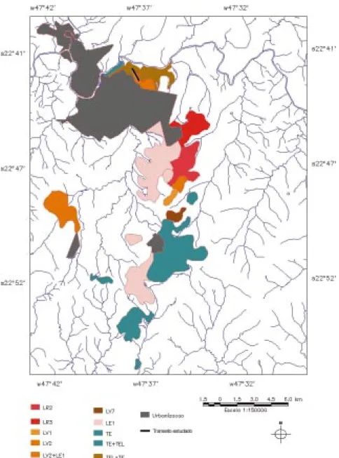
Studying the planialtimetric and soil maps (Oliveira & Prado, 1983) of the region around the study area, various flat summits whose altitudes vary between 580 and 650 m, with medium textured soils, classified as Latossolos Vermelho-Amarelos (Typic Hapludox) and Latossolos Vermelhos (Typic Hapludox) were observed. Side by side with these soils, configuring an abrupt transition, red clayey soils derived from the diabase were also found and classified as Latossolos vermelhos distro- or eutroférricos (Rhodic Hapludox), Nitossolos vermelhos eutroférricos latossólicos (Kandiudalfic
Eutrudox) and Nitossolos Vermelhos eutroférricos típicos (Rhodic Kandiudalf or Kandiudalfic Eutrudox). These summits were aligned in a NNE-SSW direction between the Capivari and Piracicaba rivers (Figure 3). This alignment correlates with the direction observed by Penteado (1968) for the tectonic barriers formed by the exposed diabases.
Observing the soil survey map of Piracicaba (Oliveira & Prado, 1983), no fine sandy textured soils were found on the eastern side of these barriers; clayey textured soils were predominant in that area. These evidences suggest that the summits, where the close transition between the sandy textured and the red clayey Latossolos (Oxisols) predominate, would be vestiges of a long regional tectonic barrier. This barrier would have acted as an obstacle to the
(a) (b) (c)
(d) (e) (f)
(g) Botucatu formation (JKb)
Piramboia formation (TrJb) Corumbatai formation (Pc) Irati formation (Pi) Diabase sill (JKsg)
S a n d y C e n o z o i c d e p o s i t correlated with the Rio Claro formation
moving sandy sediments that were transported and reworked from a higher position towards the west, where the Triassic-Jurassic sandstones of the Piramboia formation (TrJp) outcrops dominate.
Second depositional event
The study of a second road cut (T2), located at km 3 of the road connecting Piracicaba (SP) to Monte Alegre (SP), showed the presence of a second stoneline at a depth of about 470 cm at the contact between a red clayey deposit (Munsell hue of 2,5YR)
and the diabase saprolite. It is formed by centimetric quartzite pebbles that have a very high degree of roundness. Its lateral conformation follows the contact between these materials disappearing at the relief rupture, suggesting a second lithological discontinuity. At a higher position the stoneline appears at the contact between the same red clayey deposit and the saprolite of the Iratí formation; in this segment of the transect it ascends gradually disappearing on the surface (Figure 1 and 8). This evidence indicates that the red clayey deposit could have been a colluvium.
Table 2. Fe, Zr, Ti, and Ti/Zr value relations of samples taken from a pit (T3) on the limit between the summit and shoulder segments To prove that the stoneline lies between two different materials and that it could be a vestige of an erosion pavement, elemental Zr and Ti were determined and statistical comparisons of the granulometric distribution of the sand fraction were established.
The study of two profiles on the summit, located 100 m from each other, showed that there are significant differences between the values of elemental Zr and Ti found above and below the stoneline (Tables 1 and 2). These differences are in some cases higher or equal to the ones reported by Drees & Wilding (1973) as indicators of lithological discontinuities, therefore confirming the lithological differences between the studied materials. Care has to be taken in the interpretation of these results as there is not enough information in literature specifying the necessary difference to indicate a lithological discontinuity for soil studies in tropical climates. Other studies should be realized to complement these analyses.
Sample Depth Iron Zirconium Titanium Ti/Zr
No cm _____________________ % ____________________
01 30 15.58 0.0509 4.18 82.12
02 60 16.42 0.0452 3.35 74.11
03 90 16.46 0.0431 3.21 74.47
04 120 16.7 0.0448 3.35 74.77
05 165 16.91 0.0541 3.65 67.46
06 215 16.67 0.0501 3.18 63.47
07 250 16.59 0.0487 2.58 52.97
08 350 16.54 0.0421 2.2 52.25
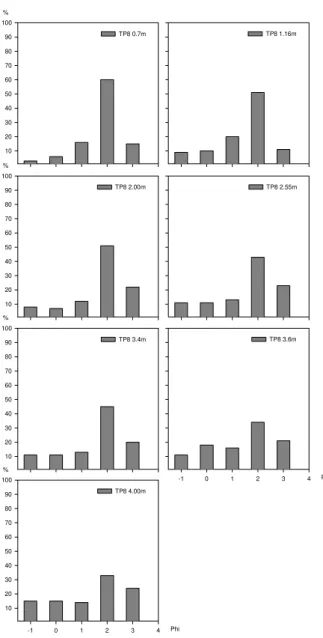
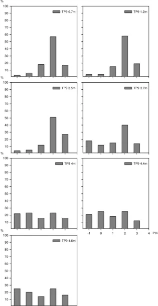
The analyses of the particle-size distribution of sediments using statistical index’s and parameter’s help to establish precise comparisons between sediments and/or soil horizons aided to understand the inferences of nature on the depositional micro-environments and possible lithological discontinuities (Riquier, 1969; Suguio, 1973; Van Lier & Vidal Torrado, 1992). Analytical data of samples from two deep auger borings (Tp8 and Tp9), taken from the summit at the transition between the sandy material and the clayey material, showed a change in the sand distribution between the materials above and below the stoneline (Figures 4 and 5). The first auger boring was taken where the stoneline appeared at a depth of 2,5 m and the second at 3,7 m.
TP8 1.16m % 10 20 30 40 50 60 70 80 90 100
TP8 2.00m TP8 2.55m
% 10 20 30 40 50 60 70 80 90 100 TP8 3.4m Phi
-1 0 1 2 3 4
TP8 3.6m
Phi
-1 0 1 2 3 4
% 10 20 30 40 50 60 70 80 90 100 TP8 4.00m % 10 20 30 40 50 60 70 80 90 100 TP8 0.7m
Figure 4. Distribution of five sand fractions of samples taken from the beginning of the transition between the sandy material and the red clayey deposit that overlies the Irati formation (Tp8).
Table 1. Fe, Zr, Ti, and Ti/Zr value relations of samples taken from the road cut profile (T2) on the summit segment
Sample Depth Iron Zirconium Titanium Ti/Zr
No cm ________________________ % _______________________
01 0-10 13.61 0.0675 4.1 60.74
02 10-40 15.01 0.0585 3.93 67.18
03 40-67 14.79 0.0592 3.93 66.38
04 67-115 15.04 0.0568 3.89 68.48
05 115-235 15.56 0.0625 3.93 62.88
06 235-285 14.78 0.0618 3.75 60.68
07 285-465 14.74 0.0667 3.77 56.52
08 465-480 15.33 0.0525 3.46 65.90
09 480-580 15.73 0.0433 2.23 51.50
10 630 14.35 0.0441 2.04 46.26
11 680 15.75 0.0463 2.53 54.64
% 10 20 30 40 50 60 70 80 90 100
TP9 0.7m TP9 1.2m
% 10 20 30 40 50 60 70 80 90 100
TP9 2.5m TP9 3.7m
% 10 20 30 40 50 60 70 80 90 100 TP9 4m
-1 0 1 2 3 4
TP9 4.4m PHi % 10 20 30 40 50 60 70 80 90 100 TP9 4.6m % 10 20 30 40 50 60 70 80 90 100 TP11 0.7-1.2m Phi
-1 0 1 2 3 4
% 10 20 30 40 50 60 70 80 90 100 TP11 6.2-6.7m % 10 20 30 40 50 60 70 80 90 100 TP11 4.2-4.7m Phi
-1 0 1 2 3 4
TP11 5.2-5.7m TP11 3.2-3.7m % 10 20 30 40 50 60 70 80 90 100 TP11 2.2-2.7m
TP 11 1.7-2.2m
Figure 5. Distribution of five sand fractions of samples taken from the middle of the transition between the sandy material and the red clayey deposit that overlies the Irati formation (Tp9).
Figure 6. Distribution of five sand fractions of sample taken from the red clayey deposit overlying the diabase saprolite (Tp11).
Descending along the transect, a third deep auger boring (Tp11) was sampled and analyzed. Here the stoneline appeared at 3,2 m. Figure 6 shows a repetition of the tendency observed in the previous auger borings. At Tp11, as observed for Tp8 and Tp9 borings, the sand distribution of the material above the stoneline was very similar in all three sampling points where the fine and medium sand fractions predominated.
Thin sections studies showed a greater degree of roundness of the quartz grains above than of the ones below the stoneline. Subangular quartz grains dominated below the stoneline in the diabase saprolite whereas, above it, sub-rounded quartz grains dominated.
Figure 7. Isolines showing the variation of the fine sand/coarse sand relation on the summit and shoulder segments.
Having confirmed that the stoneline separates two materials of different origin, the presence of the red clayey material deposited on the diabase sill, together with a small portion of the Iratí formation, would correspond to a more recent depositional event. This event would include an incision phase of the first pediplane and a later pedimentation process that formed a second pediment level (Bigarella & Andrade, 1965) corresponding to a younger geomorphic surface, Surface II according to Lobo (1984) (Figure 2f).
This can be explained as a result of a more energetic water flow at the beginning of the second pedimentation phase that exposed the diabase sill and a portion of the Iratí formation. A later stage with a less energetic water flow induced an aggradation process that elevated the regional base level, originating terrace deposits by sheet deposition of coarse material and fine sediments (Figure 2g). This erosion and deposition processes, alternating
Figure 8. Isolines showing the variation of the total sand on the summit and shoulder segments.
with soil development and landscape incision was also observed by Butler (1968).
The high values of elemental iron (Table 2) and high quantities of fine and medium sand (Figures 4, 5 and 6) suggest that the origin of these sediments could have been the previously weathered diabase sill with contribution of fine and medium sand from the sandy material of Surface I.
This process of transport and deposition can be confirmed by observing Figures 7 and 8 where, as the distance from the source material increases, the quantity of total sand in the soil diminishes and the relation between fine sand and coarse sand increases. Field observations also showed that the pebble size and the width of the stoneline diminished in the same direction. This shows a reduction in the kinetic energy of the mass flux as the distance from the source material increases, resulting in the deposition of coarser materials near the source and finer materials at increasing distances.
AL
TITUDE
, m
DEPTH, m
AL
TITUDE,
m
CONCLUSIONS
1. The fine sandy deposits of the higher flat summit were deposited in the form of leveled alveoluses, where the diabase sills and dikes, exposed during the excavation of the Peripheric Depression of São Paulo, acted as tectonic barriers to the sandy sediments that were eroded and transported from higher topographic positions where Piramboia formation outcrops dominate.
2. The origin of the second depositional event corresponds to a second pedimentation phase that exposed the diabase sill and part of the Iratí formation which was later covered due to an aggradational process by clayey material derived from the same diabase sill, with mixing of fine and medium sand from the sandy material deposited during the first depositional event.
3. The presence of two stratigraphical discontinuities shows that the two stonelines found at different depths have an allochthonous origin. These stonelines would probably have been part of two erosion pavements, corresponding to two different pedimentation phases that correlate with the deposition of fine sandy and clayey materials, respectively.
ACKNOWLEDGEMENTS
The authors wish to thank Dr. Iandara Alves Mendes for her advice during the geomorphological and geological studies, Dr Selma Simões de Castro for her advice during the micromorphological studies, Prof. Zilmar Ziller Marcos for his revision of the text and FAPESP (Fundação de Amparo à Pesquisa do Estado de São Paulo) for their financial support.
LITERATURE CITED
Ab’SABER, A.N. A Depressão Periférica Paulista: um setor de cirscundesnudação pós-cretácica na Bacia do Paraná. Geomorfologia, 15:15, 1969.
ABSY, M.L.; CLEEF, A.; FOURNIER, M.; MARTIN, L.; SERVANT, M.; SIFEDDINE, A.; FERREIRA DA SILVA, M.; SOUBIES, F.; SUGUIO, K.; TURCQ, B. & VAN DER HAMMEN, T. Mise en évidence de quatre phases d’ouverture de la forêt dense dans le sud-est de l’Amazonie au cours des 60000 dernières années. Première comparaison avec d’autres régions tropicales. C.R. Acad. Sci., 312:673-678, 1991. BIGARELLA, J.J. & ANDRADE, G.O. Contribution to the study
of the Brazilian Quaternary. Geol. Soc. Am., 84:333-351, 1965. Special Paper.
BUTLER, B.E. Soil periodicity in relation to landform development in southeastern Australia. In: LANDFORM studies from Australia and New Guinea. Canberra, Australian National University Press, 1968. p.231-255.
CAMARGO, O.A.; MONIZ, A.C.; JORGE, J.A. & VALADARES, J.M.A.S. Métodos de análise química, mineralógica e física de solos do Instituto Agronômico de Campinas. Campinas, Instituto Agronômico, 1986. 94p. (Boletim Técnico, 106) CASTRO, S.S. Impregnação de amostras de solos para confecção
de lâmina delgada. B. Inf. SBCS, 10:44, 1985.
DREES, L.R. & WILDING, L.P. Elemental variability within a sampling unit. Soil. Sci. Soc. Am. Proc., 37:82-87, 1973. EMPRESA BRASILEIRA DE PESQUISA AGROPECUÁRIA -EMBRAPA. Sistema Brasileiro de Classificação de Solos. Brasília, Serviço de Produção de Informação, 1999. 412p. INSTITUTO DE PESQUISAS TECNOLÓGICAS - IPT. Mapa geológico do Estado de São Paulo. Escala 1: 1000000. Divisão de Minas e Geologia Aplicada do Instituto de Pesquisas Tecnológicas do estado de São Paulo. São Paulo, 1981.
JOHNSON, P.R. & BEAVERS, A.H. A mineralogical characterization of some loess-derived soils in Illinois. Soil Sci. Soc. Am Proc., 23:143-146, 1959.
LEMOS, R.C. & SANTOS, R.D. Manual de descrição e coleta de solo no campo. 2.ed. Campinas, Sociedade Brasileira de Ciência do Solo/Serviço Nacional de Levantamento de Ciência do Solo, 1984. 46p.
LICHTE, M. Stonelines as a definite cycle feature in southeast Brazil: A geomorphological and pedological case study. Pedologie, 40:101-109, 1990.
LOBO, A.E.M. Relações solos-superfícies fisiográficas em uma topossequência em Piracicaba. Piracicaba, Escola Superior de Agricultura “Luiz de Queiroz”, 1984. 164p. (Tese de Doutorado)
MELO, M.S. & PONÇANO, W.L. Gênese, distribuição e estratigrafia dos depósitos cenozóicos no Estado de São Paulo. São Paulo, Instituto de Pesquisas Tecnológicas, 1983. 74p. (Série Monografias, 9)
MELO, M.S. A formação Rio Claro e depósitos associados: sedimentação neocenozóica na Depressão Periférica Paulista. São Paulo, Universidade de São Paulo, Instituto de Geociências, 1995. 143p. (Tese de Doutorado) OLIVEIRA, J.B. & PRADO, H. Levantamento pedológico
semidetalhado do Estado de São Paulo: Quadrícula de Piracicaba. Campinas, Instituto Agronômico, 1983. (Soil map scale 1:100.000)
PENTEADO, M.M. Geomorfologia do Setor Centro Ocidental da Depressão Periférica Paulista. Rio Claro, Universidade de São Paulo, Instituto de Geografia, 1968. 86p. (Tese de Doutorado)
RANZANI, G.; FREIRE, O. & KINJO, T. Carta de solos do município de Piracicaba. Piracicaba, Escola Superior de Agricultura "Luiz de Queiroz", 1966. 85p.
RIQUIER, J. Contribution à l’etude des “Stone-lines” en régions tropicale et equatoriale. Cah. ORSTOM, Ser. Pedol., 7:71-113, 1969.
RUHE, R.V. Stone lines in soils. Soil Sci., 87:223-231, 1959. RUHE, R.V. Elements of soil landscapes. In: INTERNATIONAL
SOIL SURVEY STAFF. Keys to soil taxonomy. 5.ed. Blacksburg, Pocahontas, 1997. (Soil Management Support Serv. Tech. Mon., 19)
STOOPS, G. Relict properties in soils of humid tropical regions with special reference to central Africa. Catena Supplement, 16:95-106, 1989.
SUGUIO, K. Introdução à sedimentologia. São Paulo, Edgard Blucher, 1973. 317p.
TARDY, Y. Paléoclimats et cycles climatiques. In: TARDY, Y., ed. Le Cycle de l’Eau. Masson, 1986. p.210-244.
TRICART, J. & CAILLEAUX, A. Traité de géomorphologie V. Le modelé des regions chaudes, forêts et savanes. Paris, SEDES, 1965. 322p.
van LIER, Q DE JONG & VIDAL-TORRADO, P. PHI: programa de microcomputador para análise estatística da granulometria de sedimentos. R. Bras. Ci. Solo, 16:277-281, 1992.
VIDAL-TORRADO, P. & LEPSCH, I.F. Morfogênese dos solos de uma topossequência com transição B Latossólico x B textural sobre migmatitos em Mococa (SP). R. Bras. Ci. Solo, 17:109-119, 1993.
VIDAL-TORRADO, P. Pedogênese e Morfogênese no Distrito de Tupi (Piracicaba-SP). São Paulo, Escola Superior de Agricultura “Luiz de Queiroz”, 1994. 205p. (Tese de Doutorado)