UNIVERSIDADE DO ALGARVE
FACULDADE DE CIÊNCIAS DO MAR E DO AMBIENTE
FLEET DYNAMICS IN MULTISPECIES
TRAWLERS: A STUDY BASED ON
FISHERIES-DEPENDENT DATA
Tereza Cristina Pilar-Fonseca
Dissertação
Doutoramento em Ciências do Mar, da Terra e do Ambiente
Ramo das Ciências e Tecnologias das Pescas
Especialidade em Avaliação e Gestão de Recursos
Trabalho efectuado sob a orientação de:
Professor Doutor Manuel Seixas Afonso-Dias
Universidade do Algarve / Centro de Investigação Marinha e Ambiental - CIMA
Doutora Maria Aida Viana da Silva Campos
Instituto Português do Mar e Atmosfera - IPMA / Departamento do Mar e Recursos Marinhos - DMRM
2
UNIVERSIDADE DO ALGARVE
FACULDADE DE CIÊNCIAS DO MAR E DO AMBIENTE
FLEET DYNAMICS IN MULTISPECIES
TRAWLERS: A STUDY BASED ON
FISHERIES-DEPENDENT DATA
Tereza Cristina Pilar-Fonseca
Dissertação
Doutoramento em Ciências do Mar, da Terra e do Ambiente
Ramo das Ciências e Tecnologias das Pescas
Especialidade em Avaliação e Gestão de Recursos
Trabalho efectuado sob a orientação de:
Professor Doutor Manuel Seixas Afonso-Dias
Universidade do Algarve / Centro de Investigação Marinha e Ambiental - CIMA
Doutora Maria Aida Viana da Silva Campos
Instituto Português do Mar e Atmosfera - IPMA / Departamento do Mar e Recursos Marinhos - DMRM
3
Declaração de autoria de trabalho
Declaro ser a autora deste trabalho, que é original e inédito. Autores e trabalhos consultados estão devidamente citados no texto e constam da listagem de referências incluída.
© 2013 Copyright Tereza Cristina Pilar-Fonseca.
A Universidade do algarve têm o direito, perpétuo e sem limites geográficos, de arquivar e publicitar este trabalho através de exemplares impressos reproduzidos em papel ou de forma digital, ou por qualquer outro meio conhecimento ou que venha a ser inventado, de o divulgar através de repositórios científicos e de admitir a sua cópia e distribuição com objectivos educacionais ou de investigação, não comerciais, desde que seja dado crédito ao autor e editor.
4
Acknowledgements
I would like to thank many people who have helped me through the completion of this dissertation.
I thank Aida Campos, my supervisor, for her guidance, friendship, and trust in me.
To Professor Manuel Afonso-Dias for having accepted in being my supervisor.
I gratefully acknowledge Paulo Fonseca for his support and friendship.
I would also like to thank João Pereira and the other co-authors of the articles published for my thesis, especially my colleagues Beatriz Mendes, Victor Henrique and Joaquim Parente. To IPMA for being my “home” these last years.
To my friends Melissa Shinn, Ana Paula Oliveira, Alexandra Teixeira, Samantha Birch and Fernando. A special mention goes out to Gonçalo João for his friendship, dedication, patience and the conversations.
I am forever grateful to my parents, for everything.
To the rest of my family, friends and colleagues, thank you!
The present work was undertaken in the Portuguese Institute for Sea and Atmosphere (former Instituto de Investigação das Pescas e do Mar - IPIMAR). During the study period, the present candidate benefited from a PhD grant from the Portuguese Foundation for Science and Technology (Fundação para a Ciência e Tecnologia – FCT: SFRH/BD/43409/2008).
Esta tese foi financiada pela Fundação para a Ciência e a Tecnologia através da Bolsa de doutoramento SFRH/BD/43409/2008 (FCT): “Analysis of the Portuguese coastal trawlers fleet Dynamics based on landings composition and vessel monitoring system data”.
5
Resumo
Ao longo deste estudo, foram integrados diversos tipos de dados dependentes da pesca com vista a examinar a segmentação da frota portuguesa de arrasto costeiro, bem como estimar o esforço de pesca e os desembarques por unidade de esforço para as espécies comerciais mais importantes. Numa primeira fase, foram analisados dados de desembarques por viagem com o objectivo de identificar perfis de desembarque (LPs), ou seja, grupos homogéneos de viagens de pesca em termos da respectiva composição específica, definidos pela importância relativa das espécies-alvo e espécies acessórias. Complementarmente, foram definidos componentes da frota (FC) associados a estes LPs, correspondendo a grupos de embarcações envolvidos nas mesmas estratégias de pesca ao longo do tempo. A dinâmica da frota de arrasto de peixe foi analisada utilizando uma série temporal correspondente a 13 anos de viagens de pesca, de 1995 a 2007, para um total de 74 arrastões da frota, com o objectivo de definir padrões consistentes de actividade. A aplicação de métodos partitivos de análise multivariada (Clustering Large Applications - CLARA) às proporções de espécies desembarcadas em cada viagem, permitiu identificar seis perfis de desembarque distintos. Dois destes LPs corresponderam a grupos de viagens que tiveram como espécies-alvo o carapau (Trachurus trachurus) e o verdinho (Micromesistius poutassou); nos restantes quatro, as lulas (Loligo spp.), o carapau e os polvos (Octopodidae) foram as espécies mais representadas, juntamente com a faneca (Trisopterus luscus), a cavala (Scomber colias) e a sarda (Scomber scombrus).
A correspondência entre LPs e arrastões permitiu definir três FCs, constituídas por grupos de embarcações distintas em termos das respectivas características técnicas e perfis de desembarque preferencial, dirigidas a diferentes grupos de espécies.
Foram registados desembarques num total de 21 portos diferentes, quatro (Matosinhos, Aveiro, Figueira da Foz e Nazaré) dos quais contribuíram com 66% do total de viagens de pesca. A actividade desta frota relativamente aos diversos perfis de desembarque foi caracterizada recorrendo a critérios de estabilidade (proporção das FTs consecutivas com o mesmo LP), polivalência (importância da LP principal em relação às restantes LPs), e fidelidade (proporção das FTs realizadas numa dada região), das embarcações aos respectivos LPs e portos de desembarque, permitindo uma análise preliminar das estratégias e tácticas de pesca.
6 Foi identificado um grupo de embarcações de maiores dimensões, com comprimento (fora a fora) médio de 30 metros e 900 HP (662 kW) de potência, dirigido à captura dos pelágicos como o carapau e o verdinho. Apesar de mais activos na zona centro do país, com mais de 40% das viagens nesta zona, estes arrastões operaram ao longo de toda a costa durante o período em análise. Um segundo grupo de embarcações de menores dimensões (comprimento médio de 25 metros) e potência mais reduzida (600 HP/441 kW) concentra a sua actividade na região centro, desembarcando um conjunto de espécies que inclui carapau e cefalópodes, entre outras. Estas embarcações apresentam grande polivalência em relação às tácticas de pesca adoptadas, alternando entre LPs em viagens consecutivas. Finalmente, um grupo muito reduzido, compreendendo os arrastões mais antigos da frota, com cerca de 17 metros e 250 HP (184 kW), opera exclusivamente na costa algarvia, capturando cefalópodes e peixes bentónicos.
Os padrões temporais e espaciais relativos aos diversos LPs foram analisados, tendo sido registadas variações sazonais bem marcadas a nível das viagens onde o carapau e a lula foram espécies-alvo, e variações, embora menos evidentes, no LP dedicado aos polvos. Nas viagens dirigidas ao carapau e ao polvo, foram registados desembarques ao longo de toda a costa. Já no LP onde o verdinho foi espécie-alvo, 80% dos desembarques foram registados no Norte e Centro, o mesmo acontecendo para a lula, desembarcada quase exclusivamente nas regiões Centro e Norte, revelando um padrão geográfico de captura bastante restrito.
O potencial da informação georreferenciada, correspondendo aos registos do MONICAP, o sistema Vessel Monitoring System (VMS) nacional, das viagens de pesca das embarcações em estudo, foi demonstrado ao longo desta análise, quer na quantificação do esforço de pesca, quer na identificação de tácticas de pesca e padrões geográficos de actividade. Para este estudo, a Universidade do Algarve disponibilizou um conjunto de dados relativos às viagens de pesca da frota de arrasto de peixe durante o ano de 2003, compreendendo registos com intervalo de 10 minutos. Estes dados, previamente processados com recurso a um software específico - GeoCrust 2.0 -, foram reanalisados para esta frota, com vista à identificação mais precisada duração das viagens de pesca das diferentes embarcações e, dentro destas, dos lanços de pesca. Para efeitos práticos da estimação do esforço, foram identificadas, com base em regras de velocidade definidas para esta frota, duas fases operacionais durante as viagens, correspondendo à fase de arrasto (pesca) e não-arrasto (outras operações, compreendendo a navegação entre o porto e pesqueiro; navegação entre pesqueiros; e
7 manobras de largada e viragem da arte). A estimação efectiva do esforço envolveu pois, individualmente, para cada viagem, a quantificação do tempo de duração da viagem em número de horas, bem como a quantificação do número total de horas de pesca ao longo dos diversos lanços da viagem, para um total de 44 embarcações, das 74 inicialmente seleccionadas.
A combinação das quantidades desembarcadas por espécie, em cada viagem, com o esforço de pesca estimado deste modo, permitiu a estimação dos desembarques por unidade de esforço (LPUE, proxy das capturas por unidade de esforço por sua vez podendo ser considerado um proxy da abundância do recurso): desembarques por dia no mar (LPDAS) e desembarques por hora de arrasto (LPHT). Estas estimativas foram obtidas para as principais espécies-alvo (carapau, verdinho, lula e polvo), a nível dos respectivos LPs, para as viagens individuais do subconjunto de navios acima referidos, integrantes da frota em 2003. A integração desta informação com dados georreferenciados correspondentes aos registos VMS, permitiu o mapeamento e a visualização das actividades da pesca, demonstrando a existência de diversos padrões de actividade e das estratégias de captura específicos para esta frota.
Para os cefalópodes, os dados georreferenciados foram integrados com dados relativos à estrutura populacional, permitindo a estimação do esforço por intervalo de comprimentos e a análise de padrões geográficos da estrutura populacional. São apresentados dois casos-de-estudo, relativos ao polvo e à lula capturados em 2003, onde a amostragem por comprimentos recolhida no âmbito do PNAB/DCF (Plano Nacional de Amostragem Biológica/Data Collection Framework), em viagens de pesca posteriormente classificadas em termos dos LPs definidos, foi integrada com os registos VMS correspondentes. A intensidade de pesca foi então mapeada, juntamente com a estrutura populacional, associando estes registos à quadrícula adoptada pelo ICES (0.5º em latitude x 1.0º em longitude), sugerindo uma possível relação entre o padrão geográfico de exploração e a estrutura populacional destas duas espécies. Para o polvo, os resultados mostram que a pressão de pesca é mais intensa na zona de Aveiro, coincidindo com as zonas de reprodução e com as maiores concentrações de biomassa para esta espécie. A lula está sujeita a uma maior exploração na zona Centro, em áreas próximas da costa onde ocorrem concentrações de juvenis, e ainda no barlavento algarvio.
8 Da análise conjunta dos desembarques da frota por viagem para o período de 1995 a 2007, bem como de registos VMS existentes para um período de cinco anos, 2000 a 2004 (correspondendo a dados de qualidade com intervalo de 10 minutos entre registos), foi escolhido um grupo de arrastões, desembarcando regularmente ao longo da maior parte do primeiro período, com informação georreferenciada distribuída regularmente ao longo dos cinco anos. Estas embarcações, com actividade cobrindo os diversos LPs definidos, foram seleccionadas com o objectivo de constituírem uma amostra representativa da frota de arrasto de peixe para o efeito de estimação do esforço de pesca e dos LPUEs, para as espécies-alvo definidas nesta pescaria. Os registos VMS pertencentes a este conjunto de embarcações foram inteiramente processados para o período de 2000 a 2004 permitindo obter o esforço de pesca efetivo por viagem: a sua duração total e o número de horas arrastadas, e as estimativas dos respectivos LPUEs (LPDAS e LPHT). Os dois estimadores dos esforços (duração da viagem e número de horas arrastadas) foram obtidos por LP, para o ano de 2003 e para o conjunto dos cinco anos de 2000 a 2004. Os estimadores LPDAS e LPHT, acima definidos, foram também obtidos por LP para este conjunto de embarcações em 2003.
A comparação entre os estimadores de esforço para o período de 2000 a 2004 envolveu, numa primeira fase a comparação entre a frota seleccionada e as restantes embarcações para o ano de 2003. Numa segunda fase estes estimadores foram comparados, dentro da frota de referência entre o ano-base e o conjunto dos restantes quatro anos. O comportamento da frota, i.e., a duração das viagens e o tempo de arrasto, manteve-se relativamente constante dentro de cada LP ao longo deste período.
A representatividade deste conjunto de embarcações em termos da estimação do LPUE foi examinada no período de 2000 a 2004, comparando os LPUE observados na frota seleccionada, para as diferentes espécies/grupos analisados, com os valores -correspondentes estimados para esta mesma frota. Estes resultados foram ainda comparados, para o mesmo período, com uma terceira série de LPUEs, estimados com base nos mesmos indicadores de esforço, mas onde as viagens de pesca são as viagens da frota na sua totalidade. Esta frota demonstrou ser uma possível candidata para a amostragem do LPUE para algumas das principais espécies comerciais, num programa de amostragem dirigido.
Os resultados globais desta tese demonstram o potencial decorrente da integração de dados dependentes da pesca na produção de informação específica, contribuindo para a
9 gestão e planeamento integrados da pesca por arrasto de fundo, em consonância com os objectivos da nova Política Comum das Pescas (PCP) e da Directiva-Quadro da Estratégia Marinha (DQEM) da União Europeia.
Palavras chave: Dados dependentes da pesca; Esforço de pesca; Desembarques por unidade de esforço (LPUE); Informação georreferenciada; Dados VMS (Vessel
10
Abstract
Fishery-dependent data from the Portuguese coastal fish trawl fleet were integrated to examine fleet segmentation and dynamics along a 13-year period, and estimate species-directed effort and abundance. Six landing profiles (LPs) were based on the relative importance of target and by-catch species, including horse mackerel (Trachurus
trachurus) and blue whiting (Micromesistius poutassou) almost exclusive LPs, three
others corresponding to trips targeting squids (Loligo spp.), horse mackerel and octopuses, as the main species. LPs were assigned to trawlers, defining fleet components with specific technical characteristics and fishing strategies. This showed that large vessels target pelagics along the entire coastline, average-powered units fished a diverse catch off the Central zone of the western coast, including horse mackerel and cephalopods and a group of trawlers targeted cephalopods and benthic species off the south coast.
Vessel Monitoring System (VMS) data, processed by GeoCrust 2.0, was used to quantify effective fishing effort and define geographic patterns of fishing activity. VMS-based species-specific effort from 2003 was integrated with landings to estimate landings per unit effort (landings per day at sea and landings per hour trawled. Integration of cephalopod size-classes data with VMS information enabled the estimation of size-dependent effort and analysis of geographical patterns of population structure.
A group of vessels with landing activity and VMS coverage of trips belonging to distinct LP were selected to constitute a potential sample fleet for estimating species-directed LPUE. Their representativeness in terms of effort and LPUE was examined by comparing these results with those obtained for the entire fleet. This reduced fleet was found to be a possible candidate for a sampling programme under the EU Data collection Framework. Overall findings highlight the benefits of combining fisheries-dependent data, to produce information relevant for integrated management, in accordance with the Common Fisheries Policy and Marine Strategy Framework Directive objectives.
Keywords: Fishery-Dependent Data; Fleet dynamics; Fishing Effort; Landings per unit effort; Vessel monitoring system; Geo-referenced information.
11
Table of Contents
Aim of the study and list of papers ... 14
List of Papers ... 15
1. Introduction ... 19
1.1 Common Fisheries Policy (CFP), relevant concepts and management measures ... 19
1.2 Management tools ... 21
1.3 Portuguese coastal bottom trawl fisheries ... 24
2. Data analysis and main results ... 36
2.1 Fishery data reporting and information system ... 36
2.2 Integration of fisheries-dependent information in support of fisheries management ... 39
2.3 Analysis of the Portuguese bottom trawl fleet ... 42
3. Discussion ... 53
3.1 Fleet segmentation – time and spatial patterns of activity ... 53
3.2 Estimation of effort and LPUE ... 55
3.3 Improving sampling programme at the scope of the Data Collection Framework ... 55
3.4 Final considerations ... 56
4. References... 58
12
List of Figures
Figure 1.1 - Map of study area - Portuguese mainland waters.. ... 25 Figure 1.2 - Scheme of the various gear components of the otter bottom trawl (OTB). 28 Figure 2.1 - Number of fishing trips (y-axis) by landing profile (LP) and Map of Portuguese coastline, including ICES subdivision IXa ... 48 Figure 2.2 - Map of fishing intensity and size-structure for trips targeting octopus and squid. ... 51
List of Tables
Table 1.1 - Management measures and legal provisions for Portuguese fisheries ... 23 Table 1.2 - General information for the different species landed by the Portuguese trawl fleet. ... 30 Table 2.1 - Fleet segmentation for the Portuguese fish trawlers in the period 1995-2007. ... 46
List of Abbreviations
CFP Common Fisheries Policy
CPUE Catch per unit effort
DCF Data Collection Framework
DGRM Directorate-General for Natural Resources, Safety and Maritime Services EAFM Ecosystem-based approach to fisheries management
EC European Commission
EU European Union
FC Fleet component
FT Fishing trip
GIS Geographical information system
GPS Global Positioning System
GT Gross tonnage
ICES International Council for the Exploration of the Sea
IPMA Instituto Português do Mar e da Atmosfera (in Portuguese), Portuguese Institute of Sea and Atmosphere
13 MSFD Marine Strategy Framework Directive
MSP Maritime Spatial planning. IMP Integrated Maritime Policy
HP Horse power
UNCLOS United Nations Convention of Law of the Sea
LP Landing profile
LPDAS Landings per day at sea LPHT Landing per hour trawled
LPT Landing per trip
LPUE Landings per unit effort
PNAB national biological sampling plan
TAC Total allowable catch
VMS Vessel monitoring system
EEZ Economic Exclusive Zone
kg kilogrammes kW Kilowatts g gram m meters mm millimeters nm nautical miles t tonnes
14
Aim of the study and list of papers
In this study fishery-dependent data were analysed and integrated to examine fleet segmentation, temporal and spatial patterns of activity and to estimate species-directed effort for the Portuguese coastal fish trawl fleet. Available data on landings (in weight and value) were used to identify landing profiles (LPs), and associated fleet components.
High-resolution Vessel Monitoring System (VMS) processed data was used to quantify effective fishing effort and define geographic patterns of fishing activity. VMS-based species-dependent effort was integrated with landings to estimate landings per unit of effort (LPUE) as a proxy of abundance. Integration of size data with VMS information was carried out for two species targeted by this fleet, allowing estimation of size-dependent effort and analysis of geographical patterns of population structure.
A group of vessels with regular landing activity and VMS coverage in trips belonging to the distinct LP was selected to constitute a sampling fleet for estimating species-directed abundance for this fishery.
The objectives of this study are:
- to examine fleet segmentation and fleet dynamics, analysing time and spatial patterns of fleet activity (Papers 1 to 3);
- to analyse spatial information from existing high-resolution VMS data in order to estimate effective fishing effort and LPUE for the most important species targeted by this fleet (Papers 4 to 7);
- to map geographical patterns of fishing activity, demonstrating the existence of time and spatial targeting strategies (Papers 2, 4, 5, 6 and 7);
- to show how fishery-dependent data regularly collected can be optimized to gain a better understanding of this fishery (all papers).
The results demonstrate the utility of fisheries dependent data to produce specific information tools in support of fisheries management, in accordance with the objectives of the Common Fisheries Policy (CFP) and the Marine Strategy Framework Directive of the European Union (EU).
These questions have been addressed in a total of three sections and seven papers. In section 1 (Introduction) the framework for the new Common Fisheries Policy is presented and management measures are described. The Portuguese coastal bottom trawl fisheries are characterized. Section 2 (Data Analysis) is a description of work,
15 where the relevant aspects on methodology and results are presented and discussed. Section 3 is a general discussion with final considerations and recommendations. Papers 1 to 3 address fleet segmentation and activity patterns in the coastal trawl fleet; Papers 4 to 7 estimate and map species-specific and size-specific effort and abundance.
List of Papers
Paper 1
Campos, A., Fonseca, P., Fonseca, T., Parente, J., 2007. Definition of fleet components in the Portuguese bottom trawl fishery. Fisheries Research 83: 185-191. In this study, landing profiles (LPs) were defined by the relative importance of their target and by-catch species, based on monthly aggregated landings of the entire trawl fleet during the 2002-2004 period. A correspondence was established between these LPs and three main fleet components, or groups of trawlers involved in the same fishing pattern over time: the crustacean fleet, licensed for 55-59 and 70 mm codend mesh sizes, targeting the rose shrimp, Parapenaeus longirostris and the Norway lobster,
Nephrops norvegicus; the ‘fish’ fleet, licensed for 65 mm mesh size, mainly targeting
semi-pelagic fish species such as the horse mackerel, Trachurus trachurus; and a small number of 65 mm codend mesh size trawlers having the cephalopods and benthic fish species as their most important landings.
Paper 2
Pilar-Fonseca, T., Campos, A., Afonso-Dias, M., Fonseca, P., Pereira, J., 2008. Trawling for cephalopods off the Portuguese coast – fleet dynamics and landings composition. Fisheries Research 92: 180–188.
This study focused on segmentation for the two latter components defined in Paper 1, also using monthly aggregated data from the same period. Within the fish fleet a total of 12 different LPs were identified, from which four were found to be related to cephalopods and associated species. Vessel monitoring information combined with landings data introduced a spatial analysis of the fishing trips (FT) targeting cephalopods, including vessels engaged seasonally and at full-time in cephalopod fisheries, mainly the octopus Octopus vulgaris, the squid Loligo vulgaris and the cuttlefish Sepia officinalis. The effects on the landing proportions of a number of variables, year, season and vessel, were analysed for each of the species studied.
16 Linkage between landings and VMS data provided for the definition of spatial patterns of activity by mapping the fleet trajectories and subsequently identifying geographical areas of activity.
Paper 3
Pilar-Fonseca, T., Campos, A., Fonseca, P. Afonso-Dias, M.. Activity patterns for Portuguese fish trawlers based on a 13-year time-series of daily landings. Submitted to Aquatic Living Resources.
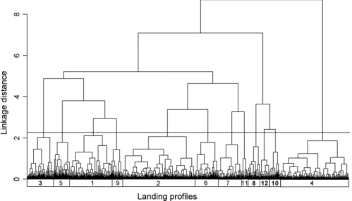
In this study, the dynamics of Portuguese fish trawlers operating in western Iberian waters was analysed along a 13-year time-series of daily landings from 1995 to 2007, with the purpose of obtaining consistent patterns of activity over time. A total of six LPs differing in species composition were defined, using the classification method Clustering Large Applications (CLARA) applied to species proportions, in weight and value. Two distinct LPs were defined in weight, exclusively targeting pelagic horse mackerel (Trachurus trachurus) and blue whiting (Micromesistius poutassou). The remaining four LPs corresponded to mixed fisheries, where squid (Loligo spp.), horse mackerel and octopuses (Octopodidae) were identified as main targets. Three fleet components (FC) were identified, targeting distinct ecological groups that differed in their technical characteristics, LP stability and polyvalence, and fidelity to a geographic region. Large vessels targeting mainly pelagic species were found to be active along the entire coast. Average powered units concentrated their activity in the centre of Portuguese mainland waters, landing a diversified catch, including horse mackerel and benthic species. These vessels were observed to frequently change their fishing tactics, switching between LPs on a trip-by-trip basis. Low-powered and old vessels targeted cephalopods and benthic species off the south coast. Preliminary estimates of species-directed LPUE (Landings per Trip) were presented.
Paper 4
Pilar-Fonseca, T., Campos, A., Fonseca, P., Mendes, B., Henriques, V. and Afonso-Dias, M. 2012. The importance of satellite-based vessel monitoring system (VMS) for fisheries management: A case study in the Portuguese trawl fleet. In Maritime Engineering and Technology.
The purpose of this paper was to illustrate the usefulness of satellite-based VMS data consisting of vessel location and speed. Collected for fisheries control in fisheries
17 research the outputs provided by this system make it possible to map and quantify the fishing activity. VMS data with 10-minute interval was processed for a Portuguese coastal trawler operating off the west coast, using GeoCrust 2.0, a geographical information system which identifies fishing trips and towing events (hauls) within trips. This information was then used to characterize vessel activity. It was shown that high-resolution VMS data provides an understanding of fishing tactics and derives more precise series of effort estimates.
Paper 5
Pilar-Fonseca, T., Campos, A., Pereira, J. Moreno, A., Lourenço, S., Afonso-Dias, M. Exploitation patterns and size composition of Octopus vulgaris in Portuguese waters (Northeast Atlantic) derived from fine-scale geo-referenced bottom-trawl commercial catches. Accepted for publication in Fisheries Research.
This study represented a first attempt to integrate different sources of information obtained at commercial trip-level, with the objective of providing a perspective of octopus population structure and relative distribution, together with information on the exploitation pattern in 2003. High-quality resolution sequential geo-referenced data were obtained from the VMS for fishing trips targeting octopus. Fishing trips undertaken on the north-western coast were used to provide information on volume and size distribution of landings. Our results show that most of the fishing intensity was directed off the region of Aveiro, where the smaller octopus were found. This is an area where important fish nurseries are also located and coincides with known octopus biomass concentration.
Paper 6
Pilar-Fonseca, T., Pereira, J., Campos, A., Moreno, A., Fonseca, P.., Afonso-Dias, M. VMS-based Fishing Effort and Population Demographics for the European squid (Loligo vulgaris) off the Portuguese Coast. Accepted for publication in Hydrobiologia. This study presented a one-year synopsis of the trawl fishery for the European squid
Loligo vulgaris in Portuguese waters, integrating length structured landings with
corresponding geo-referenced fishing activities. From VMS, landings and biological sampling data, a “status-report” was obtained for 2003. Fishing pressure was found to be most intense in inshore areas of the northwest and the south coasts of Portugal. Larger squid were found offshore in the northwest and south coasts, whereas all inshore
18 western areas showed larger proportions of small squid relative to those in the south.
Paper 7
Species-directed effort and LPUE indicators using fishery-dependent information (manuscript)
This study, based on Paper 3, shows an approach with a focus on fishery-dependent information to estimate the abundance and species-specific fishing effort for commercial species. Landings from individual fishing trips were combined with geo-referenced data obtained through VMS for the Portuguese finfish coastal trawlers operating in national waters. Processed VMS data from this fleet were used to examine exploitation patterns, through the definition of trips and hauls, with an estimation of trip duration and number of hours trawled by trip, using the GeoCrust 2.0 software. A fleet representative of the landing profiles (LPs) previously identified in Paper 3 is proposed, based on high-resolution 2000-2004 VMS data. These data provided an increase in the accuracy of in fishing effort and landings per unit of effort (LPUE) estimates, from previous figures obtained in LPT (landings per trip), to landings per day at sea (LPDAS) and finally, landings per hour trawled (LPHT), for the different LPs. Comparison of these estimates with those obtained for the entire fleet was carried out in order to check the representativeness of the selected fleet to estimate fishery-based species-specific abundance indexes for the fishery. The main objective was to define a sampling fleet that can be used to adequately sample fishing effort and abundance for the main commercial species.
This Ph.D. project includes and extends previous work in the theme of fleet segmentation using landings data, within the frame of the Programme “MARE: Fishing Technologies”, (MARE, FEDER, QCA-III, 22-05-01-FDR-00014; 2000-2007). This study started under the responsibility of the former INRB/L-IPIMAR (Portuguese Institute of Biological Resources/Fisheries and Sea Research Laboratory), currently integrated in the “Instituto Português do Mar e da Atmosfera” (hereinafter referred to as IPMA - Portuguese Institute of Sea and Atmosphere) as the Department of Marine Resources.
19
1. Introduction
In this section important aspects of the Common Fisheries Policy (CFP) are presented, and relevant management tools in support of the CFP reform are described. A description of the Portuguese coastal bottom trawl fisheries is provided.
1.1 Common Fisheries Policy (CFP), relevant concepts and management
measures
The European CFP was established in 1983 for the conservation, management and sustainable exploitation of the Sea (Council Regulation (EEC) No 170/83). The principle of relative stability was adopted in the annual division of Total Allowable Catches (TACs) and distribution into fishing quotas by Member States based on their historical catches registry. The detailed rules for recording information of Member States' catches were set in Regulation (EEC) No 2807/83. The first reform of the CFP took place in 1992 (Council Regulation (EEC) 3760/92), with the need to tackle the overcapacity of the EU fleet by introducing fishing effort measures. A second reform
(Council Regulation No 2371/2002, “Framework Regulation”) provided the CFP with a
longer-term perspective on fisheries management by establishing recovery and management plans, creating Regional Advisory Councils (RAC) and implementing the precautionary principle in fisheries management in order to minimize the impact of fishing activity on marine ecosystems and prevent environmental degradation.
The third reform of the CFP, which is still under discussion (COM(2009) 163) will focus on long-term sustainability, through the application of exploitation rates set at levels of maximum sustainable yield (MSY). Emphasis will be placed on a regionalized approach to fisheries management, with the establishment of fishery-based plans and mitigation measures to be tailored to specific fisheries. This will require a higher responsibility and improve compliance behavior by the fishing sector. The relevance and implementation of the ecosystem-based approach to fisheries management (EAFM) and the mitigation of the wasteful practice of discarding will also become central issues under the new CFP. A discard ban is being discussed for those species assessed in international fora such as the International Council for the Exploration of the Sea (ICES). This implementation is phased in according to species (pelagic/demersal) and fisheries.
20 The ecosystem approach to fisheries management is not easy to define; the concept behind EAFM is about ensuring that “benefits from living marine resources are high while the direct and indirect impacts of fishing operations on marine ecosystems are low and not detrimental to the future functioning, diversity and integrity of these ecosystems” (COM(2008) 187). This concept is derived from more general definitions in the Convention on Biological Diversity (CBD) and in the ICES, being partially related to the preservation of biodiversity and habitat conservation (Habitats Directive 92/43/EEC). The implementation of EAFM requires information on the state of the marine environment, including pressure indicators related to its different uses (SEC(2008) 449). The Marine Strategy Framework Directive (MSFD, Directive 2008/56/EC) establishes a framework to achieve or maintain good environmental status in the marine environment by 2020.
The importance of this approach is stated for the Atlantic Ocean in COM(2011) 782 “Developing a Maritime Strategy for the Atlantic Ocean Area”. This document emphasizes the need for a reformed CFP based on regionalisation and simplification targets, in order to promote fisheries management that is able to react more quickly and efficiently to changing ecological or economic conditions. Within this context, EU instruments for an integrated maritime policy and territorial cooperation are supporting pilot projects on spatial planning and coastal zone management in the Atlantic. Single species management will be replaced by multi-species long-term plans, while the spatial component play an increasingly important role as a broader set of ecosystem interactions need to be considered.
The relevance and implications of analysing fleet dynamics for multi-species fisheries has been demonstrated as a spatial, fleet-based management and governance tool, in line with the EU Common Fisheries Policy, the Integrated Maritime Policy (IMP, COM (2007) 575) and the Maritime Spatial Planning (MSP, COM(2008) 791). The need to analyse fishery-data at a more regional (local) scale may also benefit various other EU directives and policies, including the MSFD (Directive 2008/56/EC) already transposed into Portuguese legislation (Decreto-lei nº 108/2010 altered by Decreto-lei nº 201/2012).
21
1.2 Management tools
Since the first CFP reform, fleet capacity has been progressively regarded as an important factor for the conservation policy. Limitations to this capacity were set with the objective of bringing it into line with available resources, hence ensuring fishing at a sustainable level. Management measures have thus evolved from control of catches (e.g. TAC) to effort control (e.g. days-at-sea). Fisheries management measures, or rules, are grouped into the following types: output control (catch limits), input control (fishing effort limitations), and technical measures. Output and input controls are related to fishing mortality, the former directly controlling quantities captured (TACs), and the latter indirectly controlling quantities by restricting fishing effort, and thus fleet capacity or fishing activity. Technical measures are directed at more specific goals and include gear restrictions (e.g. codend mesh size), real time closures and species minimum landing sizes (MLS). A combination of these three types of measures is used in European fishery policies.
Authorizations for the acquisition or construction of new fishing vessels and for the use of fishing gear, and annual fishing licenses are additional input instruments used to manage this activity. Licenses are granted on the basis of stock status, operating areas, vessel characteristics and condition, the amount of fishing gear per vessel, the previous year’s catch, and any cases of repeated failure to comply with the rules. Since 2003 there has been a strict entry-exit rule, and the number of vessels per year has been kept relatively constant or has been reduced in order to adjust fishing effort to sustainable exploitation patterns and the state of the resources, namely in relation to fishing capacity (e.g., vessel parameters).
The main fishery conservation management tools used are Total Allowable Catches (TAC's) and quotas, fixed on an annual basis. The European Commission (EC) defines TAC’s as “quantitative limits on landings that are set at the level of stocks or group of stocks” (Churchill and Owen, 2009). TAC’s are decided upon by the Member States (MS) in the Council after a proposal from the Commission with scientific advice from ICES and the Scientific, Technical and Economic Committee for Fisheries (STECF). TACs are divided into quotas for each Member state, which can be further allocated among vessels if Individual Transferable Quotas (ITQs) are implemented.
Fishing effort is defined by the United Nations Food and Agriculture Organisation (FAO) as “the product of the capacity and the activity of a fishing vessel” with capacity
22 measured in kilowatts (kW) of engine power and activity measured in time (days) (COM(2007) 39). Fishing activity can be more accurately estimated as the time during which the fishing gear is in operation and is effectively fishing (COM (2007) 39).
Fishing activity is frequently referred to in a vast number of ways such as fishing pressure (Lambert et al., 2012; Stelzenmuller et al., 2008), and fishing intensity (Piet and Quirijns, 2009), fishery footprint (Jennings et al., 2012), among others. Examples of fishing effort management measures are limitations in the number of fishing licenses (capacity) and in the number of fishing days (activity), as well as restrictions in the number and characteristics of vessels and/or gears.
Both TACs and effort measures (i.e. output and input control, respectively) are aimed at the regulation of fishing mortality. Conservation measures comprise a number of ways to regulate exploitation patterns while keeping the fishing level constant. They include the so-called technical measures for conservation purposes, which are used to prevent by-catch of juvenile fish or species that are not targeted. The Basic Regulation (Council Regulation (EC) No 1954/2003) provides the legal framework for the adoption of technical measures. Technical measures regulate the structure of fishing gear, the restriction or prohibition of fishing in certain zones and periods, limitations in size of individuals that may be retained on board and/or landed, and specific measures that may be used to reduce the impact of fishing activities on marine ecosystems and non-target species.
The EAFM (Jennings et al., 2001; Stergiou et al., 2003) calls upon a fleet- and area-based approach to fisheries management (Council Regulation (EC) No 1343/2007) requiring the integration of diverse fisheries information. Incorporating fleet- and fishery-based approaches into the advisory system is particularly relevant in multi-species fisheries (Scientific, Technical and Economic Committee for Fisheries, 2007). The fisheries sector was initially monitored via fisheries-dependent information using a paper based format recording catches, landings and sales. Over the past decade the Electronic Recording and Reporting System (ERS) has been implemented to collect data on fishing activity and send the information to fisheries authorities in the Member States (Commission Implementing Regulation (EU) No 404/2011) and, increasing data accuracy in this way. One of the main instruments for control and compliance is the satellite-based vessel monitoring system (VMS), which tracks the geographical position for all vessels over 15 metres in length.
23 The Data Collection Framework (DCF, Commission Decision 2008/949/EC) is an important tool aimed at ensuring a sound basis for policy, decision-making, and support for scientific advice regarding the CFP. The DCF operates by adopting a multiannual Community program for the collection, management and use of data in the fisheries sector at biological, ecological, operational and economical levels.
The Portuguese legislation on conservation, management and control is consistent with regulations set by measures established at the international and European level. The main national and corresponding EU regulations (e.g. Decree Law 43/1987 and national legislation –Portaria- nº 1102-E/2000) are listed in Table 1.1. Currently, the main national entity responsible for controlling the fishing sector is the “Direção-Geral de Recursos Naturais, Segurança e Serviços Marítimos” (DGRM, Directorate-General for Natural Resources, Safety and Maritime Services, the former Directorate-General for Fisheries and Aquaculture, DGPA SEC(2007) 425).
Table 1.1 - Management measures and legal provisions for Portuguese fisheries, including trawl fisheries. Control is made by DGRM alone or in cooperation with other entities. Legislative Decrees and national legislation are listed (only number is shown).
Rules Europe National legislation
INPUT
Permit for fishing vessels and gear
Annual fishing licenses Fishing activity
Council Regulation 3094/86 Council Regulation (EC) No
1954/2003 Fishing effort Adjustment plans (FEAP)
DR 43/1987 (amended by DR 3/89, 28/90, 30/91 and 7/2000)
Nº 301/2010 for the Southern Hake and Nephrops Recovery plan OUTPUT
Annual TACs and quotas (year 2012)
Council Regulation (EU) 44/2012 sets TACs for 2012
nº 177/2012 (for 2011)
Technical measures Mesh sizes
Target species and species percentages (limits)
Minimum Landing Sizes Spatial and temporal restrictions (EC) No 850/1998. (EU) No 579/2011. (EC) No 517/2008 Reg. (EC) 850/98 (EC) 2166/2005, CR (EC) 850/98
nº 1102-E/2000 (mesh size), nº 769/2006 Nº 27/2001 altered by nº 1266/2004 nº 1102-E/2000 nº 419-B/2001 nº 296/94 establishing fishing closures
REPORTING AND COMPLIANCE Vessel activity at sea
Logbooks, Landings, VMS
First sale market
Council Regulation (EC) nº 1224/2009 Commission Implementing Regulation (EU) No 404/2011 Decree-Law n.º 310/98 nº 313/2011 Legislative Decree 81/2005
24
1.3 Portuguese coastal bottom trawl fisheries
1.3.1 Fleet capacity and area of activity
In Portuguese mainland waters, fishing is carried out by a total of three distinct fleet segments: trawl, seine and polyvalent fleets. In 2012, the trawl fleet landed 14456 tonnes and 36224 Euros which accounted for 9% and 12% approximately of the total national landings in weight and value, respectively (INE, 2013).
The trawl fleet activity is regulated by National legislation n. 1102-E/2000 (“Regulamento da Pesca por Arte de Arrasto”). This fleet is divided into two sub-segments: the bottom trawl (OTB) fleet and the beam trawl. The fleet selected for this study is the bottom trawl fleet corresponding to Portuguese trawlers operating in ICES areas VIIIc, IXa and IXb and exploiting demersal assemblages (segment 4k3, Commission Regulation (EC) No 2091/98, Figure 1.1). In 2002, a total of 110 coastal trawlers (4k3) were active with a fleet capacity of 19936 Gross Tonnage (GT, Council Regulation (CEE) Nº 2930/86) and 54894 kW (Kilowatts), with a corresponding cumulative fishing effort of 6.4*106 GT*days (17.3*106 kW*days, COM(2003) 508). By the end of 2011 the number of vessels had been reduced to 82 units with a total of 38260 kW and 14977 GT.
The fleet operates all year round in the geographical area of the Northeast Atlantic waters of the Iberian Peninsula (ICES divisions VIIIc and IXa, excluding the Gulf of Cadiz. Fishing activity is mainly concentrated within the limits of the geological continental shelf (until 200 m depth), extending to the slope-edge. Vessels from the bottom trawl fleet may operate anywhere along the entire Portuguese continental coast (36º to 42ºN and 7º to 9ºW) covering an extension of approximately 523 nautical miles (n.m.). Some of the Portuguese trawl vessels are also licensed to operate in Spanish waters (including ICES division VIIb) according to a bilateral agreement between Portugal and Spain, signed in 2003. Vessels must operate at a minimum distance of 6 n.m. from the baseline but there is an exception for a small number of vessels that may operate within the 6 n.m. limit from the baseline provided that they operate outside the 6 mile of the coastline in the area between Capes of Raso and Espichel (National legislation No. 769/2006, 1102-E/2000).
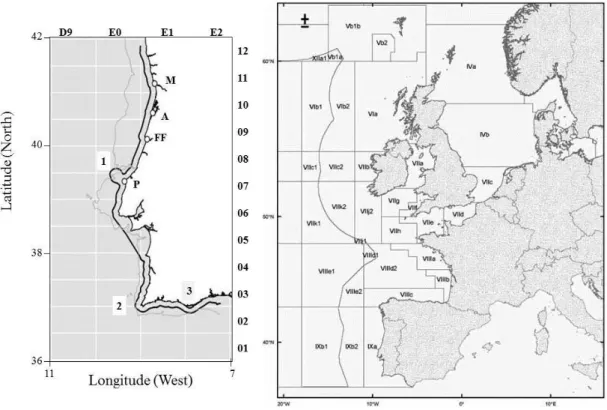
25 Figure 1.1 - Map of study area - Portuguese mainland waters. The gray contour marks the 200m isobath. The black contour is the 6 mile fishing limit from the baseline. Main fishing ports are identified: M-Matosinhos; A-Aveiro, FF-Figueira da Foz, P-Peniche. Cape Carvoeiro, Cape São Vicente (Sagres) and Cape Santa Maria (Faro) are indicated by numbers 1, 2 and 3, respectively. ICES statistical rectangles are identified in top and right axes. Left map spatial extent: 36 to 42ºN and 7º to 11ºW.
1.3.2 Geographical area and species assemblages
The Portuguese mainland is characterized by an L-shaped continental shelf and a steep slope-edge (Figure 1.1). The width of the continental shelf varies along the coastline, from around 40 km wide off the northern coast to 10 km wide south of Lisbon, increasing slightly to the southwest and southern coasts. This narrow shelf is cut by various topographical features including submarine canyons (Relvas et al., 2007), which constitute a physical constraint for trawling activity. Other constraints are related to the existence of patches of rough and rocky seafloors and steep slopes.
The mainland shelf is divided into four main areas according to bathymetric characteristics: north of Nazaré canyon; between Nazaré and Setúbal; Setúbal and São Vicente canyon; and South coast. In terms of the seabed substrate the area is divided into five sections (MAMAOT, 2012 - Portuguese MSFD): the northern platform from the north frontier to the Nazaré canyon; between Nazaré and the parallel of the Cape of Raso, known as Estremadura margin; between Capes of Raso and Espichel, also known as the mouth of the river Tagus; the southwest platform between Capes of Espichel and
26 S. Vicente; and finally the Algarve platform, between the Cape of S. Vicente and Guadiana river. In the north a sandy-gravel seafloor is observed between the coastline and the 100 m depth range. In the Estremadura margin, the sediment is mainly composed of sand, whereas at the mouth of the river Tagus the coastal area is dominated by sand, complemented by an extensive mud deposit at depths between 100 and 150m. Predominantly sandy in the southwest coast, the characteristics for the south platform are variable, from sandy-gravel to muddy seafloor.
Portuguese waters are found in a transitional zone located between the warmer waters of the Atlantic and the Mediterranean ecosystems to the south and the east respectively, and the colder Atlantic waters to the north. The Iberian system is under the influence of the seasonal upwelling of Eastern North Atlantic Central Water (ENACW), linked to the Canary Current and the North Atlantic Oscillation (NAO). The south coast is influenced by the high salinity water mass known as Mediterranean Outflow (MOW) (Relvas et al., 2007). These waters are also influenced closer to the coast and at a local level by freshwater runoff from the Iberian Peninsula. The river basins contributing to the freshwater runoff include Mondego, Vouga, Tagus and Guadiana. A recurrent buoyant plume Western Iberian Buoyant Plume (WIBP) is observed, mainly in winter (Peliz et al., 2002).
Situated in a transition zone between temperate and tropical ecosystems, the whole area is characterized by high biodiversity and relatively low abundance of marine species. The western coast is affected by the existence of seasonal upwelling, particularly up to the north of Nazaré canyon. Hydrological conditions are a determinant factor in the distribution and abundance of small pelagics such as sardine (Sardina pilchardus), mackerel (Scomber spp.) and horse mackerel (Trachurus trachurus). Moreover, the bathymetry, as well as bottom geological nature, strongly influences the distribution and abundance of pelagic and demersal species.
Analysis of groundfish trawl surveys (Sousa et al., 2005) conducted off the Portuguese coast identified the existence of five spatially distinct fish assemblages in the area in study. Most species are confined to certain depth and latitudinal ranges. On the shelf (<150 metres) horse mackerel and boarfish (Capros aper) dominate in autumn and summer assemblages, respectively. On the upper slope, the fish community is dominated by blue whiting (Micromesistius poutassou); in the south, this community includes a high number of deep-water species, including crustaceans.
27 Small pelagics represent a high fraction (58% in 2012 from six species, INE, 2013) of total landings for the continental coast. Among them, the most captured is sardine, exclusively targeted by coastal seiners in shallow waters. For the remaining pelagics, mackerels and mainly the horse mackerel, the bottom trawl fishery contributes to a high percentage of their landing weight.
1.3.3 Gear operation
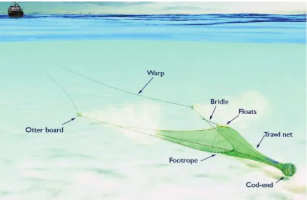
The vessels engaged in coastal bottom trawling off the Portuguese coast are stern trawlers towing one net. In these vessels, the trawl is horizontally opened by means of the spreading force generated by the trawl doors, while the vertical opening is achieved by the use of floats and weights in the trawl headline and footrope, respectively. The footrope provides bottom contact for higher fishing efficiency, being adapted to the seafloor type. For hard bottoms bobbins are used to preserve the gear from possible abrasion and damage, whereas in soft sandy or muddy bottoms chains are used at the footropes to revolve the substrate. Figure 1.2 shows the various gear components and the rigging in the bottom trawl. The trawl net is bag-shaped starting with a pair of wings connected to the trawl body and ending in a codend, where the catch is retained. The top of the wings are connected to the bridles, the trawl doors (oval or rectangular structures made of iron) and the warps.
28 Figure 1.2 - Scheme of the various gear components of the otter bottom trawl (OTB). Warps, trawl doors (otter sweeps (bridles), wing, groundrope (footrope) with bobbins, headrope with floats (floatline), trawl net and codend.
During the haul operation, the organisms vulnerable to the trawl sweeping area, including benthic, demersal or semi-pelagic species, are guided (e.g. pelagic fish with higher swimming capacity and active behaviour towards the net) or passively directed (e.g. crustaceans and benthic fish species) from the wings to the codend, where they are retained. Retention requires that trawl duration and trawling speed is adapted towards the swimming behaviour of fish (Campos, 2003). Towing speeds generally vary from 2.5 to 5.0 knots, essentially depending on the swimming capacity of the target species, although for higher speeds vessel capacity and vessel power can be a limiting factor. Codend retention depends to a high extent on the amount of fish retained and on how the dimension and shape of the codend meshes adapt to the morphology of these organisms.
The trawl and rigging, in particular the doors and footropes, have a direct physical impact on the seabed, scraping and ploughing the sediments and causing re-suspension and physical destruction, removal or scattering of non-target benthos, with possible long-term destruction to the benthic habitats. The fishing operation further affects the seabed through post-fishing mortality of damaged or disturbed organisms, including discarding practices (Jones 1992; Kaiser and De Groot, 2000).
29 1.3.4 Catch composition and general characterization of trawl fleet segments
The Portuguese continental waters can be viewed as transition system between the Mediterranean and the North Sea, sharing characteristics of both. This feature and the fact that the area of operation of the fish coastal trawl fleet, extends for approximately 523 n.m., a number of fish assemblages, characterized by a high diversity, are exploited (Gomes et al., 2001;Sousa et al., 2005). Therefore, landings comprise a large number of pelagic and semi-pelagic fish species, as well as benthic fish and cephalopod species, and deep-water crustaceans. In 2012, horse mackerel, blue whiting, blue jack mackerel (Trachurus picturatus), hake, Spanish mackerel, rose shrimp, and pouting were the most important species regarding landings in weight (INE, 2013).
Some of the main management measures currently in force are shown in Table 1.2. Until 2000 the fleet was licensed by type of fishery (crustacean versus ‘non-crustacean’/fish trawling, using 55 and 65 mm mesh size codends, respectively). Presently, it is regulated by (three different) classes of cod-end mesh size: 55-59 mm, 65-69 mm and >=70 mm. Target and by-catch percentage catch restrictions (minimum limits of target species and maximum for the by-catch) are set according to the cod-end mesh size intervals in this fleet. Minimum landing sizes (MLS) apply for a large number of species (Table 1.2).
Crustacean fleet
The crustacean fleet operates on the continental slope off the southwest and southern coasts (36 to 37ºN and 7º to 9ºW - Figueiredo and Viriato (1989) and consists of approximately 30 Portuguese vessels (27 vessels operating in 2012), plus a number of Spanish trawlers licensed by the scope of the Multilateral Agreement. These vessels target mainly rose shrimp (Parapenaeus longirostris) and Norway lobster (Nephrops
norvegicus) at trawling speeds varying from 2.5 to 3.5 and even 4.0 knots (Afonso Dias and Pinto, 2008), using low-opening trawls rigged with footropes equipped with chains to revolve the soft substrates where they operate. Using VMS data, a total of nine fishing grounds were identified (Afonso-Dias et al., 2002): one in Lisbon Region (36 to 37ºN and 7º to 9ºW); two in the south-west (Alentejo coast, Sines and Arrifana area); and six on the south coast, covering an area of about 1412 nm2, in a depth range between 50 and 1000 metres.
30 Table 1.2 - General information for the different species (or group of species) landed by the Portuguese trawl fleet. Name and FAO code. Ecology: Pelagic (P), bentho-pelagic (BP), demersal (D) and benthic (B). Species sampling priority group (G1 and G2, Commission Decision
2008/949/EC). Minimum Landing size (MLS, in cm). TAC for 2012 (Y – yes;N – no). Mesh classes
(55, 65 and 70 mm), minimum percentage of target species, MPTS (30%, 70% and null) and target species indicated with X (National legislation, portaria 419-B/2001, decree-law 769/2004). Species with Total Allowable Catch (TAC) for 2012 (COM(2011) 717 final).
Species group FAO
Species code Ecology Priority Group*1 MLS (cm) 55-59 65-69 >=70 TAC2012 MPTS
Latin name Common Name 30% 70% Null
Trachurus
trachurus Horse mackerel HOM P G2 15 X X
Y
Micromesistius
poutassou Blue whiting WHB P G1 - X X Y
Scomber
scombrus Mackerel MAC P G1 20 X X Y
Trisopterus
luscus Pouting BIB BP G2*
2
17 X X N
Scomber colias Spanish mackerel MAS P G1 20 X X N
Octopus vulgaris Common octopus OCT D G2*2 0.75kg X X N
Merluccius
merluccius Hake HKE D G1 27 X Y
Sparidae Sea breams BP G2 X X N
Loligo vulgaris Long finned-squid SQC P G2*2 X X N
Scyliorhinus spp Catsharks SCL D X X N
Raja spp Rays and skates SKA D G1 X Y
Zeus faber John Dory JOD BP G2 X X N
Sepia officinalis Cuttlefish CTC D G2 X X N
Microchirus spp Thickback soles THS D G2*2 18*3 X X N
Lophius spp Monkfish MNZ D G2*2 X Y
Mullus spp Mullets MUX D G2*2 15*3 X N
Solea spp Flatfishes SOX D G1*2 24 X Y
Nephrops Norway lobster NEP D G1 20 X Y
Parapenaeus longirostris Rose shrimp DPS D G2 24 X X N Aristeus antenatus Red shrimp ARA D - X X N
*1Group 1 (G1): Species that drive the international management process including species under EU management plans or EU recovery plans or EU long term multiannual plans or EU action plans for conservation and management; Group 2 (G2): Other internationally regulated species and major non-internationally regulated by-catch species”
*2– more general (e.g. Trisopterus spp) or specific/taxonomic (e.g. Octopus vulgaris). *3 - relative to a particular species, e.g. Microchirus azevia (18); Mullus surmuletus (15)
The distribution of crustaceans partially overlaps, although they are characterized by different depth distributions. While rose shrimp can be found between 150 and 440 metres in sandy mud bottoms, Norway lobsters prefer compact mud between 300 and 500 m (Cascalho, 1995), and are targeted down to depths of 700 metres and more. Other less abundant target species are the shrimps Aristeus antennatus and Aristaeomorpha
31
foliacea, captured between 400 and 700 m approximately (Cascalho, op.cit.; Figueiredo, 1989). Two minimum legal codend mesh size classes are allowed when trawling for crustaceans: a mesh size of 55-59 mm for shrimps, including the rose shrimp (Parapenaeus longirostris); and 70 mm for the Norway lobster (Nephrops norvegicus). No TACs apply to the rose shrimp, but a MLS is set (24 mm of carapace length). By-catch restrictions are also set, but only when 55-59 mm cod-ends are used (Council Regulation No 850/98 and in annex of the Portuguese National Legislation nº
1102-E/2000), with a minimum of 30% of shrimps regarding the total catch in weight and a
maximum of 30% of protected by-catch species (Table 1.2), with the exception of blue whiting (Micromesistius poutassou), captured in high quantities in this fishery. However, when using different classes of mesh size during the same trip the percentage of shrimps can be reduced to 20%.
Fish fleet
The vessels licensed for 65-69 mm and/or 70mm codend mesh size (National legislation No 1102-E/2000; Commission Regulation (EC) no. 2244/2003) target a number of species including pelagic or semi-pelagic such as horse mackerel (Trachurus
trachurus), blue whiting (Micromesistius poutassou), mackerels (Scomber colias and S. scombrus), and squids (Loligo spp.), as well as a number of cephalopods and benthic
fish species such as octopuses (Octopus vulgaris and Eledone cirrhosa), hake (Merluccius merluccius), flatfishes and several seabreams. In this case, trawling speed is adapted to the specific targets, ranging from 3.0 knots to 5.0 knots and more. Trawl dimensions and rigging also varies according to the target species and type of bottom. This fleet operates along the entire coastline from 36 to 42ºN and 7º to 10 ºW. The main effective fishing effort occurs in the shelf area (up to 200m depth), although vessels may engage in fishing activity almost anywhere beyond the 6 n.m. distance.
By-catch restrictions for the 65 mm mesh size are set at a maximum of 30% in weight for species. The percentage of crustaceans catches were initially not allowed above 20% but since 2006 have increased to allow for percentages above 30% when the vessel uses more than one mesh size during a fishing trip (Portuguese National Legislation nº 1102/-E2000 amended by National Legislation nº 796/2006).
32
Recovery Plan for Southern hake and Nephrops
Southern hake and Norway lobster (Nephrops) stocks are managed under a Recovery Plan (Council Regulation (EC) No 2166/2005) that establishes measures for the recovery of these two stocks in the Cantabrian Sea and Western Iberian (ICES regions VIIIc and IXa, Figure 1.2). Under this Recovery Plan (Council Regulation (EC) No 2166/2005) there are output controls as well as input (effort, days-at-sea) restrictions, with 10% annual reductions, regulated yearly. Percentages of individual quotas for Southern hake can be found in national legislation, with a list of about 150 and 87 fishing vessels in 2007 (National Legislation no 612/2007) and 2012 (National Legislation no 177/2012), respectively, and include vessels from the crustacean and fish otter bottom trawl fleet. In 2009, 21 national vessels in various fleet segments were decommissioned with the support public subsidies as a result of the Southern hake and Nephrops recovery plan (COM(2011) 354 final). The number of fishing vessels has been declining, and those under this recovery plan are not an exception. Complementary reductions in effort comprising fishing closures in specific areas and times of the year (boxes, Reg. EC 2166/2005) are also set to avoid catches of juveniles or protect spawning stock for Nephrops and hake.
A management plan for the western pelagic stock of Atlantic horse mackerel is also being prepared (COM(2009) 189).
The management system for these fisheries, with a high number of legal provisions including enforcement of mesh sizes, by-catch limits and effort restrictions applying to individual species, corresponds to the standard CFP model of micro-management
(COM(2011) 0425). Mismatches between MLS, minimum mesh sizes allowed and
by-catch limits were in evidence for a number of fish and crustacean species, in codend selectivity studies (Campos et al., 2002, 2003; Fonseca et al., 2007), constituting one main reason for discarding or misreporting commercial by-catch.
1.3.5 Discards
Discards can reach high levels in Portuguese trawl fisheries. In the first study on discards of the Portuguese south coast (Project BYDISCARD), Borges et al. (2001) reported discard levels of about 70% of the mean catch per trip in crustacean trawlers targeting rose shrimp. These authors also quantified discard rates for fish trawlers operating in southern waters. The average discard rate recorded for 1998-1999 and
33 2000-2001 were about 59% and 44%, respectively. Discards included mainly non-commercial species such as the longspine snipefish, Macrorhamphosus scolopax, other with low commercial value (blue whiting) and fish below MLS.
Under the Community DCF Program (national biological sampling plan - PNAB), data collection on discards is presently carried out by IPMA on a number of co-operative crustacean and fish trawlers. Discard rates, estimated for 2009 and presented in (Pérez et al., 2011), do not include a global figure for this fleet. However, these rates are provided for a high number of species. Among these, a high number is always discarded due to low or null commercial value, such as the boarfish, the bogue (Boops boops), the Henslow´s swimming crab (Polybius henslowi), the scabbardfish (Lepidopus caudatus) and the longspine snipefish. Blue whiting was found to be mostly landed, while Spanish and Atlantic mackerels, hake and pouting were species for which discard rates highly varied.
Gear-based options to mitigate unwanted by-catch that forms the bulk of discards have been tested (see Campos, 2003). The first options tested used square mesh codends, followed by sorting panels and square mesh panels placed at different trawl sections
(Campos and Fonseca, 2004, 2007) and sorting grid systems (Fonseca et al., 2005a, 2005b, 2006). However, the regulations applied to trawl fisheries in Portugal, including fishing closures within the scope of the Recovery Plan (Reg. EC 2166/2005), as well as existing control measures, do not encourage fishermen to adopt the gear modifications proposed or develop new options to reduce by-catches. The discard ban, recently proposed during the current CFP review, should become an incentive to use these types of devices that have already been introduced in a number of fisheries within the EU and abroad.
In developing integrated technical measures to avoid discard practices and protect special ecosystems, customized regional and local approaches are essential, and will probably include flexible spatial closures. This emphasizes the relevance of monitoring and analysing data from the fishery data reporting system, namely geospatial tracking information, which is one of the objectives of the present study.
1.3.6 Control and compliance
In Portugal, retained commercial catches are reported at the first sale auction known as the “lota” (Legislative Decree 81/2005), managed by the public company