www.ccarevista.ufc.br ISSN 1806-6690
Pedogenesis in a topo-climosequence in the Agreste region of
Pernambuco
1Pedogênese em uma topoclimossequência no agreste de Pernambuco
Carlos Roberto Pinheiro Junior2, Marcos Gervasio Pereira3*, Ademir Fontana4, Lucia Raquel Queiroz Pereira
da Luz5 and Thaís de Andrade Corrêa Neto6
ABSTRACT -The Borborema Plateau is characterized by different stages of relief evolution, which modify the climate and vegetation, and where high-altitude tropical forests can be seen surrounded by caatinga. The aim of this study was to characterize the soils of a topo-climosequence in the Agreste region of the State of Pernambuco, and evaluate the influence of the relief and climate on the pedogenesis. A topo-climosequence was selected, and trenches were opened in the geomorphological features of high-altitude forest (P1), between forest and pediplane (P2) and on a pediplanation surface (P3 and P4). A morphological description and a physical, chemical and micromorphological characterization were carried out. In general, the soils are sandy, with the predominance of a single-grain structure or weak aggregation. Higher values for pH, S, V% and assimilable P were found on the lower parts of the landscape. From the micromorphological analysis, the incipient development of pedogenic structures was detected in the C horizon in P1 and P3, clay translocation in P2 and the degradation of iron micronodules in P4. The P1 and P3 profiles were classified asNeossolos Regolíticos Distróficos espessarênicos (Regolsols), the P2 profile as a
Argissolo Amarelo Distrófico típico (Alisol), and P4 as anPlanossolo Háplico Eutrófico arênico (Planosol). Soil variation in the landscape was determined by climate, relief and parent material. Micromorphology was efficient in detecting attributes not seen in the field, such as incipient aggregation in the Neossolos Regolíticos (Regosols) and the degradation of iron micronodules in the Planossolo Háplico (Planosol).
Key words: Relief. Micromorphology. Sandy soils.
RESUMO -O Planalto da Borborema é caracterizado pelos diferentes estágios de evolução do relevo, modificando o clima e
a vegetação, sendo observadas florestas tropicais, (brejos de altitude), circundado por caatinga. O objetivo deste trabalho foi caracterizar os solos de uma topoclimossequência no agreste pernambucano, avaliandoa influência do relevo e do clima na pedogênese. Foi selecionada uma topoclimossequência e abertas trincheiras nas feições geomorfológicas de brejo de altitude (P1), entre brejo de altitude e pediplano (P2) e em superfície de pediplanação (P3 e P4). Foi realizada a descrição morfológica e a caracterização física, química e micromorfológica. De maneira geral, os solos são arenosos, com predomínio da estrutura grão simples ou fraca agregação. Maiores valores de pH, S, V% e P assimilável foram quantificados nas partes mais baixas da paisagem. Na análise micromorfológica detectou-se o desenvolvimento pedogenético incipiente de estrutura nos horizontes C de P1 e P3; translocação de argila em P2; e degradação de micronódulos de ferro em P4. Os perfis P1 e P3 foram classificados como Neossolos Regolíticos Distróficos espessarênicos (Regosols); P2 como Argissolo Amarelo Distrófico típico (Alisol); P4 como Planossolo Háplico Eutrófico arênico (Planosol). A variação dos solos na paisagem foi determinada pelo clima, relevo e material de origem. A micromorfológica foi eficiente na detecção de atributos não observados em campo, como agregação incipiente nos Neossolos Regolíticos e degradação de micronódulos de ferro no Planossolo Háplico.
Palavras-chave: Relevo. Micromorfologia. Solos arenosos. DOI: 10.5935/1806-6690.20190021
*Author for correspondence
Received for publication in 13/08/2017; approved in 15/05/2018
1Pesquisa financiada pela CAPES Proex
2Programa de Pós-Graduação em Agronomia-Ciência do Solo, Universidade Federal Rural do Rio de Janeiro/UFRRJ, Seropédica-RJ, Brasil,
[email protected] (ORCID ID 0000-0002-2721-6704)
3Departamento de Solos, Universidade Federal Rural do Rio de Janeiro/UFRRJ, Seropédica- RJ, Brasil, [email protected] (ORCID ID
0000-0002-1402-3612)
4Centro Nacional de Pesquisa de Solos, Embrapa Solos, Rio de Janeiro-RJ, Brasil, [email protected] (ORCID ID 0000-0001-7624-8676) 5Centro Nacional de Pesquisa de Solos, Embrapa Solos, Recife- PE, Brasil, [email protected] (ORCID ID 0000-0002-3988-5729)
6Pós-doutoranda do Programa de Pós-Graduação em Agronomia- Ciência do Solo, Universidade Federal Rural do Rio de Janeiro/UFRRJ,
INTRODUCTION
Among the factors that influence soil formation, relief and climate are most often considered the main determinants of pedogenesis due to their influence on water flow and chemical weathering. Variations in relief are responsible for a number of changes in the characteristics and attributes of the soil, as they govern both the water dynamics of the landscape and drainage, controlling the intensity of formation processes. Variations in relief determine climatic change, especially in the water regime, which in turn intensifies reactions and processes in the soil (PEDRON; AZEVEDO; DALMOLIN, 2012). As a result, the degree of soil development, as well as the dynamics of exchangeable cations and the rate of weathering, are directly related to the position of the soil in the landscape
(MEIRELESet al., 2012).
The district of Jurema, located in the Agreste region of Pernambuco, is inserted in the Borborema Plateau, characterized by different stages of relief evolution, which is reflected in the variations in climate, plant cover
and predominant lithostructure (GURGEL et al., 2013;
RODAL; BARBOSA; THOMAS, 2008). The topographic variations in the region promote changes in the climate and the occurrence of orographic rainfall with indices greater than 1,000 mm year-1 in the highest parts of the landscape,
where the altitude can reach 900 m. Such conditions are responsible for the formation of pockets of moisture where ombrophilous, evergreen, and semi-evergreen forests, known as high-altitude tropical forests, can be seen, surrounded by caatinga vegetation with a semi-arid climate (RODAL; BARBOSA; THOMAS, 2008).
With the exception of the study by Souza et al.
(2010), little is known about the high-altitude forest environments in the State of Pernambuco. Given the importance of conserving these environments due to the special conditions of humidity, temperature and vegetation, characterization of the physical, chemical and macro- and micromorphological attributes of the soil, with the aim of understanding the factors and processes active in its genesis, is an important tool for adopting management practices and maintaining the functions of the soil and organisms.
To this effect, the aim of this study was to evaluate soil genesis under the influence of relief and climate in a topo-climosequence in the Agreste region of the State of Pernambuco, Brazil.
MATERIAL AND METHODS
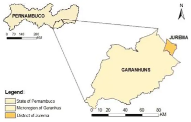
The study area is located in the district of Jurema, in the Agreste region of Pernambuco, inserted in the microregion of Garanhuns (Figure 1). The
geomorphological unit is known as the Borborema Plateau, with altitudes ranging from 200 to 900 meters. These present different stages of relief evolution, the result of tectonic influences combined with changes in climate, followed by folding and fracturing, and associated with successive leveling (BRASIL, 1983).
Figure 1 - Location of the study area in the Agreste region of Pernambuco
The geology of the region is included in the Garanhuns Group, in which the quartzites, granites and gneisses of the Proterozoic period predominate. These rocks are characterized by their coloration, which varies from whitish and yellowish to pale pink, of phanerocrystalline structure, and a mineralogy predominantly composed of quartz, feldspar and biotite. A topo-climosequence was selected for the study, and four trenches were opened in different geomorphological features: high-altitude forest (P1), between forest and pediplane (P2) and on a pediplanation surface (P3 and P4). General information on the areas whose profiles were described is shown in Table 1. The morphological description of the soil profiles was carried out as per Santoset al. (2015), and disturbed
and undisturbed soil samples were collected for laboratory analysis.
The air-dried fine-earth fraction (ADFE) was obtained from the collected samples, after drying, declumping and sieving (2 mm mesh), on which the physical and chemical analysis was carried out. Granulometry was quantified by the pipette method. Values were determined for the pH in H2O, and the Ca, Mg, Al, Na, K, assimilable
P and H+Al content (DONAGEMMAet al., 2011). The
assimilable P content was also extracted with a 0.5 mol L-1
Na2CO3 solution at pH 8.5 and quantified by colorimetry from the color intensity of the phosphomolybdic complex
as per Olsen et al. (1954). To quantify the levels of
Table 1 - General information on the topo-climosequence in the district of Jurema in the State of Pernambuco
Legend: Coord: coordinates; Mod: moderately; Sharp: sharply; Imp: imperfectly
1988). The total Fe, Al, Ti and Si content was determined
by sulfuric attack (DONAGEMMA et al., 2011), where
the samples of ADFE were solubilized in 1:1 H2SO4,
heated and then filtered. From the filtered extract, Fe2O3 and Al2O3 were quantified by complexometry with EDTA and CDTA respectively, and TiO2 by the peroxidation of titanium sulfate to persulfate with H2O2, determined by
spectrophotometry. The SiO2 content was obtained by
solubilization of the residue in NaOH and quantified by colorimetry from the color intensity of the silicomolybdic complex. From the results, the ki and kr indices were calculated. The micromorphological characterization was performed on undisturbed samples, impregnated with polyester resin to make up thin slides. The slides were then observed under a petrographic microscope, and a micropedological description made as per Bullock (1985). From the morphological, physical and chemical attributes, the profiles were classified according to the Brazilian System of Soil Classification (SANTOSet al., 2013).
RESULTS AND DISCUSSION
In general, each profile along the topo-climosequence shows a sandy texture and a poorly developed structure. The profiles at the highest points in the landscape, under the influence of a climate with greater rainfall, show low base saturation, whereas on the pediplanation surface, the semi-arid climate favors greater base saturation in P4, determined by the lower leaching rate. The profiles presented a sequence of horizons: Ap1, Ap2, C1 and C2, in the profile located in the high-altitude forest (P1); Ap, BA, Bt1 and 2Bt2 in the profile between forest and pediplane (P2); and on the pediplanation surface: Ap, C1, C2 and C3 in P3, and Ap, E, Bt1, Bt2 and Bt3 in P4.
As for the morphological attributes, each horizon in profile P1 and P3 has a single-grain structure (Table 2), just like the surface horizons of the P2 and P4 profiles.
Profile Coord. (UTM) Type of landscape/
altitude Local relief/slope Parent material
Primary vegetation/ Current use
Rainfall
(mm) Drainage
P1 0815893/9033276 High-altitude forest/753 m
Gently rolling and
rolling/5-20% Granite
Semi-deciduous
tropical forest/Pasture 1500 Well-drained
P2 0813595/9033764 Between forest and
pediplane/723 m Gently rolling/5-8% Granite
Deciduous tropical
forest/Annual crops 1000-1300
Well to mod. drained
P3 0814013/9032123 Pediplanation surface/658 m
Gently rolling and
flat/5% Granite
Hyper-xerophylic
caatinga/Pasture 500-800 Imperf. drained
P4 0811552/9037289 Pediplanation surface/625 m
Gently rolling and flat/2-5%
Granitic sandy-clay colluvial material
Hyper-xerophylic
caatinga/Pasture 500-800 Imperf. drained
The subsurface horizons of P2 have a subangular blocky structure, while a prismatic structure, composed of angular and subangular blocks, was seen in P4.
The main factor in the occurrence of a single-grain structure, are the high levels of the sand fraction in the soil, as evidenced by the presence of the sand and loamy-sand textural classes, together with a predominance of the coarse-sand fraction and consequently, a low level of mineral colloids, which hinders the formation of soil aggregates. The pattern of a single-grain structure or low degree of development, was also seen by Santos
et al. (2012) when studying the Neossolos Regolíticos
(Regosols) of the semi-arid region of Pernambuco, where there was a predominance of the loamy-sand textural class in all of the profiles under study. For blocky and prismatic structures, the principal ratio is due to the higher clay content in the subsurface.
Each horizon of the profiles under study present colors of a yellow hue (10YR), indicating the presence of goethite, whose formation is favored by the low iron content of the parent material (KÄMPF; CURI, 2000;
MEDEIROSet al., 2013).
The moist color in the surface horizons showed a predominant value of 3. The same pattern was also seen in most of the subsurface horizons, with the exception of the 2Bt2 (P2), C3 (P3) and Bt3 (P4) horizons. The predominance of this darkened color, even in the subsurface, is associated with the presence of goethite, which may present yellowish tones despite low levels of organic carbon.
By analyzing the physical attributes of the soil, a sand content greater than 700 g kg-1 was seen in most of
Horizon) Depth cm Color Structure(1) Textural class
Dry Moist
P1 – Neossolo Regolítico Distrófico espessarênico (Regosol) (High-altitude forest)
Ap1 0-30 10YR 4/3 10YR 3/3 si. grain Loamy sand
Ap2 30-75 10YR 4/2 10YR 3/2 si. grain Loamy sand
C1 75-130 - 10YR 3/3 si. grain Loamy sand
C2 130-150+ - 10YR 3/2 si. grain Loamy sand
P2 – Argissolo Amarelo Distrófico típico (Alisol) (Between forest and pediplane)
Ap 0-30 10YR 5/3 10YR 3/3 si. grain Sand
BA 30-60 - 10YR 3/3 wk., sm., sab. Sandy loam
Bt1 60-90 - 10YR 3/3 wk., sm., sab. Sandy clay loam
2 Bt2 90-160+ - 10YR 5/4 wk., sm., sab. Clay loam
P3 - Neossolo Regolítico Distrófico espessarênico (Regosol) (Pediplanation surface)
Ap 0-25 10YR 4/3 10YR 3/3 si. grain Loamy sand
C1 25-60 - 10YR 3/3 si. grain Loamy sand
C2 60-100 - 10YR 3/3 si. grain Loamy sand
C3 100-150+ - 10YR 5/2 si. grain Sandy clay loam
P4 – Planossolo Háplico Eutrófico arênico (Planosol) (Pediplanation surface)
Ap 0-20 10YR 5/3 10YR 3/2 si. grain Loamy sand
E 20-50 10YR 5/2 10YR 4/2 si. grain Loamy sand
Bt1 50-70 - 10YR 3/2 mo.,me., pri., comp. ab. and mo., me.,sab. Sandy clay
Bt2 70-100 - 10YR3/2 mo.,me., pri., comp. ab. and mo., me., sab. Sandy clay
Bt3 100-150+ - 10YR 4/3 st., me. to lg., pri., comp. ab. and mo., me., sab. Sandy clay
(1) si: single; wk: weak; mo: moderate; st: strong; sm: small; vsm: very small; me: mdium; lg: large; ab: angular blocks; sab: subangular blocks; pri:
prismatic; comp: composite
Table 2 - Morphological attributes of soils of a topo-climosequence in the district of Jurema in the State of Pernambuco
Table 3 - Physical attributes of the soils of a topo-climosequence in the district of Jurema in the State of Pernambuco
Horizon Depth Cm
Sand
Silt Clay
DF(1) % Silt/Clay FS/CS(2)
Total Coarse Fine Total Natural
g kg-1
P1 - Neossolo Regolítico Distrófico espessarênico (Regosol) (High-altitude forest)
Ap1 0-30 747 523 224 121 132 17 87 0.9 0.4
Ap2 30-75 769 533 236 117 114 40 65 1.0 0.4
C1 75-130 755 500 255 130 115 16 86 1.1 0.5
C2 130-150+ 774 547 227 116 110 17 85 1.1 0.4
P2 - Argissolo Amarelo Distrófico típico (Alisol) (Between forest and pediplane)
Ap 0-30 888 655 233 33 79 22 72 0.4 0.4
BA 30-60 776 493 283 63 161 31 81 0.4 0.6
Bt1 60-90 709 467 242 80 211 28 87 0.4 0.5
In general, the soils have a sandy texture due to the nature of the parent material, acidic rocks of the Garanhuns Group, with a phanerocrystalline structure and the predominance of the minerals quartz and feldspar. In addition, the low rate of weathering of the alterable primary minerals, which is determined by the climate, does not favor the formation of clay minerals. In the P2 profile, a sharp change can be seen in the FS/CS ratio between the Bt1 and 2Bt2 horizons, suggesting the occurrence of lithological discontinuity (NOVAES FILHOet al., 2012).
The low values for the silt/clay ratio in the subsurface horizons of P4 may be a reflection of the processes of deposition and accumulation of pre-weathered sediments in the highest parts of the landscape, considering that the current conditions of imperfect drainage and the low rainfall in the area (500-800 mm) are unfavorable to the weathering process.
There was great variation in the chemical attributes of the profiles under study (Table 4). In general, an increase can be seen in the values for pH, sum of bases (S), and assimilable P on the downward slope.
The values for pH ranged from 3.44 in the P1 profile (high-altitude forest), to 7.26 in P4 (pediplanation surface), being directly related to the increase in the value of S for the same direction in the landscape, which varied from 1.33 (P1) to 13.25 (P4). In each profile, the values for Mg were higher than for Ca. This pattern was also seen in other profiles in the State of Pernambuco, formed
from gneiss with a coating of quartz (JACOMINEet al.,
1972).
The P1, P2 and P3 profiles had a base saturation of less than 50%, a result of their dystrophic character
(SANTOSet al., 2013), followed by the S values, which
ranged from 0.77 to 3.11, and the aluminum content of
0.4 at 1.1 cmolc.kg-1. The P4 profile had a base saturation
of more than 50%, resulting from its eutrophic character
(SANTOS et al., 2013), associated with higher values
for Ca, Mg and K when compared to the other profiles. The predominantly sandy texture, which determines a low capacity for cation retention, together with the greater runoff favored by the relief in the higher parts of the landscape, intensifies base leaching, which explains the low Ca, Mg and K content of P1, P2 and P3. The occurrence of dystrophic soils at the highest points, and eutrophic soils at the lowest, was also seen by several
authors (CAMPOSet al., 2010, 2011, MEIRELESet al.,
2012), when studying the soil to landscape relationship. According to Anjoset al. (1998), this pattern of a greater
sum of bases at the lowest points is defined by the soil to landscape relationship, which controls the behavior of the water flow, as well as the processes for the removal and accumulation of cations.
Higher values for Na were found in the subsurface horizons of P4, where the semi-arid climate conditions favor the addition of Na to the soil by capillary rise from the groundwater, with the desorption of other cations in the sortive complex and the consequent increase in Na values (GONÇALVES; MARTINS; RAMOS, 2015).
The levels of assimilable P vary from 0 to 88 mg kg-1,
with the highest values in P4 compared to the other profiles. However, due to the high pH values in this profile, quantifying the P values by the Olsen method is recommended, where the levels varied from 3 to 52 mg kg-1. In this case, the use
of Mehlich-1 solution may overestimate the assimilable P content, considering that the dilute acid solution dissociates the little-soluble forms of phosphate (CORRÊAet al, 2008).
The total organic carbon content (TOC) is influenced by the low deposition of organic material
(1)DF: degree of flocculation.(2)FS/CS: fine sand/coarse sand
P3 - Neossolo Regolítico Distrófico espessarênico (Regosol) (Pediplanation surface)
Ap 0-25 802 496 306 95 103 16 85 0.9 0.6
C1 25-60 706 476 230 153 141 40 72 1.1 0.5
C2 60-100 714 484 230 144 142 12 92 1.0 0.5
C3 100-150+ 619 376 243 176 205 22 89 0.9 0.6
P4 - Planossolo Háplico Eutrófico arênico (Planosol) (Pediplanation surface)
Ap 0-20 820 496 324 130 50 15 70 2.6 0.7
E 20-50 825 523 302 110 65 15 77 1.7 0.6
Bt1 50-70 492 366 126 75 433 36 92 0.2 0.3
Bt2 70-100 500 385 115 61 439 18 96 0.1 0.3
Bt3 100-150+ 93 342 151 68 439 30 93 0.2 0.4
H(1) Depth cm pH H2O
Al Ca Mg H+Al Na K P Meh(2) P Ols(3) S T V m
Na% TOC T clay cmolc kg-1 mg kg-3 cmol
c kg-1 % g kg-1 cmolc kg-1
P1 - Neossolo Regolítico Distrófico espessarênico (Regosol) (High-altitude forest)
Ap1 0-30 3.5 1.0 0.5 1.0 6.0 0.01 0.02 9 6 1.53 7.52 20 40 0.1 9.7
-Ap2 30-75 3.4 1.0 0.3 1.0 5.2 0.01 0.02 6 4 1.33 6.51 20 42 0.2 7.5
-C1 75-130 3.4 0.9 0.4 1.0 5.5 0.01 0.02 6 5 1.43 6.96 21 39 0.1 7.8
-C2 130-150+ 3.9 0.6 0.7 1.0 5.3 0.01 0.02 10 7 1.68 7.03 24 26 0.1 10.4 -P2 - Argissolo Amarelo Distrófico típico (Alisol) (Between forest and pediplane)
Ap 0-30 4.5 0.1 0.8 1.9 3.1 0.02 0.02 7 5 2.66 5.71 47 2 0.4 7.3
-BA 30-60 4.5 0.1 0.8 1.9 3.8 0.02 0.04 6 3 2.66 6.47 41 3 0.3 5.9 24.9
Bt1 60-90 4.1 0.4 0.4 2.1 4.3 0.04 0.02 3 1 2.56 6.83 37 12 0.6 5.7 30.9 2Bt2 90-160+ 3.8 0.6 0.4 2.7 3.7 0.04 0.01 0 0 3.17 6.84 46 15 0.6 2.6 49.9
P3 - Neossolo Regolítico Distrófico espessarênico (Regosol) (Pediplanation surface)
Ap 0-25 3.9 0.7 0.1 0.7 3.1 0.01 0.02 4 3 0.83 3.90 21 46 0.3 4.2
-C1 25-60 3.9 1.1 0.1 0.6 3.8 0.01 0.01 3 1 0.77 4.57 17 58 0.2 4.2
-C2 60-100 4.0 1.0 0.1 0.6 4.0 0.01 0.01 3 1 0.77 4.73 16 57 0.2 2.0
-C3 100-150+ 3.6 1.0 0.1 0.6 3.8 0.04 0.02 4 1 0.78 4.62 17 56 0.9 2.0 44.4 P4 - Planossolo Háplico Eutrófico arênico (Planosol) (Pediplanation surface)
Ap 0-20 6.6 0.0 2.2 1.6 0.6 0.01 0.09 78 37 3.91 4.47 87 0 0.2 3.2
-E 20-50 6.9 0.0 1.8 1.3 0.5 0.01 0.09 88 52 3.20 3.66 87 0 0.3 2.0
-Bt1 50-70 7.3 0.0 4.2 8.4 0.4 0.15 0.30 41 33 12.96 13.39 97 0 1.1 3.0 32.3 Bt2 70-100 6.1 0.0 3.4 9.3 1.3 0.40 0.25 7 2 13.25 14.59 91 0 2.7 3.0 30.1 Bt3 100-150+ 6.1 0.0 2.4 9.9 0.9 0.50 0.24 15 3 13.04 13.95 93 0 3.6 0.7 31.5
Table 4 - Chemical attributes of the soils of a topo-climosequence in the district of Jurema in State of Pernambuco
(1)H: horizon(2)PMeh: phosphorous determinad by Mehlich 1.(3)POls: phosphorous determinad by Olsen (1954)
gives it greater structural stability and resistance to weathering, with a consequently lower dissolution rate, thereby influencing the Si/Al ratio (LIUet al., 2016).
According to the SiBCS [Brazilian System of Soil
Classification] (SANTOS et al., 2013), the P1 and P3
profiles present a moderate surface A horizon with the absence of subsurface diagnostic horizons, characterized by the weak action of pedogenic processes. They have a base saturation (V%) of less than 50% and a predominantly sandy texture down to a depth of over 100 cm, basically composed of quartz and feldspar. Together,
these attributes classify the profiles as Neossolos
Regolítico Distrófico típico (Regosols).
The P2 profile has a B/A textural ratio equal to 2.35, characterizing a significant increase in the clay content in the subsurface, giving rise to the subsurface textural diagnostic B horizon. The surface horizon was classified as moderate A; in addition, the profile displays a predominant yellowish color (hue 10 YR) and low base saturation. Despite the presence of high-activity clay in the Bt horizon, the dystrophic character allows it to be classified as aArgissolo Amarelo Distrófico típico
(Alisol). on the surface of P3 and P4; however for P1 and P2,
the forest results in a greater contribution; despite this,
TOC levels were lower than 10 g kg-1 in each profile,
decreasing with depth, except for horizon C2 in P1, which displayed an increase in TOC content. This result for C2 in P1 can be explained by the loamy-sand texture throughout the profile, which helps the plant root system to develop to greater depths, with the translocation of organic material.
Horizon Depth cm SiO2 Al2O3 Fe2O3 TiO2 Ki Kr Al
2O3/ Fe2O3
g kg-1
P1 - Neossolo Regolítico Distrófico espessarênico (Regosol) (High-altitude forest)
Ap1 0-30 41.0 24.0 6.0 3.8 2.90 2.50 6.28
Ap2 30-75 45.0 26.0 6.0 4.5 2.94 2.56 6.80
C1 75-130 49.0 29.0 8.0 5.8 2.87 2.44 5.69
C2 130-150+ 45.0 27.0 8.0 4.6 2.83 2.38 5.30
P2 - Argissolo Amarelo Distrófico típico (Alisol) (Between forest and pediplane)
Ap 0-30 33.0 1.07 4.0 1.3 3.30 2.87 6.67
BA 30-60 62.0 42.0 9.0 2.7 2.51 2.21 7.33
Bt1 60-90 82.0 62.0 12.0 3.2 2.25 2.00 8.11
2Bt2 90-160+ 162.0 117.0 27.0 4.4 2.35 2.05 6.80
P3 - Neossolo Regolítico Distrófico espessarênico (Regosol) (Pediplanation surface)
Ap 0-25 46.0 25.0 6.0 3.8 3.13 2.71 6.54
C1 25-60 64.0 33.0 9.0 4.0 3.30 2.81 5.76
C2 60-100 63.0 43.0 9.0 4.4 2.49 2.20 7.50
C3 100-150+ 78.0 57.0 10.0 5.2 2.33 2.09 8.95
P4 - Planossolo Háplico Eutrófico arênico (Planosol) (Pediplanation surface)
Ap 0-20 34.0 15.0 6.0 1.7 3.85 3.07 3.92
E 20-50 32.0 14.0 7.0 1.8 3.89 2.94 3.14
Bt1 50-70 163.0 92.0 39.0 4.4 3.01 2.37 3.70
Bt2 70-100 171.0 106.0 40.0 4.4 2.74 2.21 4.16
Bt3 100-150+ 160.0 96.0 37.0 4.1 2.83 2.27 4.07
The P4 profile showed abrupt textural change and yellowish colors with low subsurface saturation, reflecting its low permeability due to the imperfect drainage, thereby characterizing the planic subsurface diagnostic B horizon. This horizon presents high-activity clay, indicating the presence of type 2:1 clay minerals. In addition, the profile shows a high base saturation and a sandy texture from the surface to the start of the planic B horizon, which occurs at a depth of 50 cm. These attributes together classify the profile as an Planossolo Háplico Eutrófico arênico (Planosol).
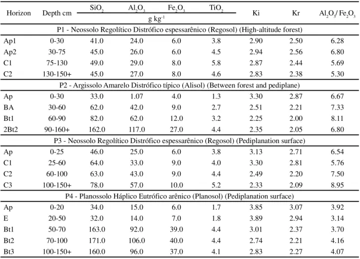
With the micromorphological analysis, it was possible to find typical features from the action of different pedogenic processes. In general, there was a predominance of quartz grains in the coarse fraction, coated in clay and organic matter. Alteration of the mineral feldspar was also found (Figure 2), in its turn, releasing silica, which explains
the higher SiO2 content of the weathering complex and
consequently the high values of the ki index.
TheNeossolos Regolíticos (Regosols) (P1 and P3),
in spite of the non-aggregated single-grain structure seen
Table 5 - Total silicon, iron, aluminum and titanium content by sulfuric attack
in the field evaluation, show evidence of the incipient action of pedality in the micromorphological analysis, where a granular microstructure with the development of a few blocks was seen. In both profiles, organization of the subsurface pores was of the impacted type with a few fissures.
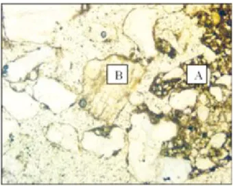
In the P1 profile, coating of the coarse fraction by clay particles and organic colloids was seen (Figure 3), which in turn act by uniting the primary particles, explaining the occurrence of an incipient blocky structure. In addition, these coatings of organic material in the subsurface may explain the increase in the TOC content of the subsurface relative to the overlying horizons, where its mobilization may have been facilitated by the predominantly thick texture.
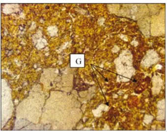
in the quartz can be seen with coating and filling by the organic matter. Another pedofeature was the occurrence of degraded iron micronodules (Figure 9), which is associated with the drainage conditions of the profile.
Pedogenesis along the topo-climosequence is strongly influenced by the felsic parent material and its interaction with the climate, determining low rates of weathering, which can be evidenced by the high amount of feldspars, contributing to the predominance of a very sandy texture. This texture, in turn, affords a slight capacity for cation retention, which together with the predominance of coarse sand, intensifies the leaching process. Variations in relief are responsible for the drainage conditions and the
Figure 2 - Photomicrograph of a gefuric weave with porphyric zones (A). Mineral feldspar under alteration (B). Horizon C1, profile P1
Figure 3 - Textural pedological crust feature in the coarse parent material (quartz), organic material and clay. Horizon C1, profile P1
Figure 4 - Photomicrograph of an open porphyric zone forming blocks (C). Horizon C2, profile P3
Figure 5 - Photomicrograph of a biological pedological feature (D). Horizon C2, profile P3
In the 2Bt2 horizon of the P2 profile, there is a predominance of quartz grains, distributed in a dense mass of fine material (porphyritic pattern) and organized in a granular microstructure and in blocks. The main pedofeatures seen were the abundant clay coating and dense clay filling of the cavitary porosity (waxiness) (Figure 6 and Figure 7).
surface runoff, altering the chemical attributes of the soil and the action of pedogenic processes, favored not only by removal and accumulation but also by cycles of wetting and drying. In addition, the climate factor, which favors the occurrence of greater rainfall in the higher parts of the landscape, intensifies leaching and surface runoff, with subsequent base accumulation in the pediplane.
Among the more active specific pedogenic processes, most important are eluviation/illuviation and elutriation, in the formation of the textural B horizon in P2; lessivage and leucinization, favoring the formation of the E horizon; and ferrolysis in the formation of the planic B horizon and E horizon in P4. The P1 and P3 profiles are characterized by the low-intensity action of the pedogenic processes, showing no subsurface diagnostic horizon;
Figure 6 - Textural pedological feature of clay filling. (E) (waxiness). 2Bt2 horizon, profile P2
Figure 7 - Textural pedological feature of internal filling of the cavitary pore: (almost a coating) (F). 2Bt2 horizon, profile P2
Figure 8 - Photomicrograph of porphyric microfissure porosity forming a prismatic structure. Bt3 horizon, P4 profile
Figure 9 - Textural pedological feature of degraded iron micronodules (G). Bt3 horizon, P4 profile
however, as seen in the micromorphological analysis, incipient action of the process of pedality can be seen.
CAMPOS, M. C. C. et al. Relações solo-paisagem em uma topossequência sobre substrato granítico em Santo Antônio do Matupi, Manicoré (AM). Revista Brasileira de Ciência do Solo, v. 35, p. 13-23, 2011.
CAMPOS, M. C. C.et al. Segmentos de vertente e atributos do
solo de uma topossequência na região de Manicoré, AM.Revista Ciência Agronômica, v. 41, n. 4, p. 501-510, 2010.
CORRÊA, R. M.et al. Disponibilidade e níveis críticos de fósforo em milho e solos fertilizados com fontes fosfatadas. Revista Brasileira de Ciências Agrárias, v. 3, n. 3 p. 218-224, 2008. DONAGEMMA, G. K.et al.Manual de métodos de análise de solos. Rio de Janeiro: Embrapa Solos, 2011. 230 p.
FANNING, D. S.; FANNING, M. C. B.Soil genesis, morphology and classification. Washington, USA, 1989. p. 69-80.
GONÇALVES, M. C.; MARTINS, J. C.; RAMOS, T. B. A salinização do solo em Portugal: causas, extensão e soluções.
Revista de Ciências Agrárias, v. 38, n. 4, p. 574-586, 2015. GURGEL, S. P. P.et al. Cenozoic uplift and erosion of structural
landforms in NE Brazil. Geomorphology, v. 186, p. 68–84, 2013.
JACOMINE, P. K. et al. Levantamento exploratório-reconhecimento de solos do Estado de Pernambuco. Recife:
DNPEA. Divisão de Pesquisas Pedológicas, 1972. v. 2. KÄMPF, N.; CURI, N. Formação e evolução do solo (Pedogênese).In: KER, J. C.; SHAEFER, C. E. G. R;
VIDAL-TORRADO, P.Pedologia: fundamentos. Viçosa, MG: Sociedade Brasileira de Ciência do Solo, 2012. p. 207-302.
KÄMPF, N.; CURI, N. Óxidos de ferro: indicadores de ambientes pedogênicos. In: NOVAIS, R. F. et al. Tópicos em ciência do solo. Viçosa, MG: Sociedade Brasileira de
Ciência do Solo, 2000. v. 1, p.107-138.
LIU, W. et al. Deep weathering along a granite ridgeline in a
subtropical climate.Chemical Geology, v. 427, p. 17-34, 2016. MEDEIROS, P. S. C. et al. Caracterização e classificação de solos graníticos em topossequência na região Sul do Brasil.
Ciência Rural, v. 43, n. 7, p. 1210-1217, 2013.
MIREILES, H.et al. Relação solo-paisagem em topossequência de origem basáltica.Pesquisa Agropecuária Tropical, v. 42, n. 2, p. 129-136, 2012.
NOVAES FILHO, J. P. et al. Indicativos de descontinuidade
litológica de regolitos derivados de granitos em uma microbacia sob floresta Amazônica, em Juruena-MT.Revista Brasileira de Ciência do Solo, v. 36, n. 2, p. 317-324,2012.
OLSEN, S. R. et al. Estimation of available phosphorus in soils by extraction with sodium bicarbonate. Washington: United States Department of Agriculture, 1954. 19 p. (Circular 939).
PEDRON, F. A.; AZEVEDO, A. C.; DALMOLIN, R. S. D. Alteração mineralógica de Neossolos em uma climo-litossequência no Planalto do Rio Grande do Sul.Ciência Rural, v. 42, n. 3, p. 451-458, 2012
of erosive processes in the removal of the finer particles, contributing to a relative increase in the clay content of the subsurface (KÄMPF; CURI, 2012).
The main pedogenic processes involved in the formation of this soil are lessivage, leucinization and ferrolysis (KÄMPF; CURI, 2012). Lessivage is characterized by the intense translocation of clay, which is facilitated by the presence of the E horizon, in turn formed by the process of leucinization, which includes the translocation of organic material, with lighter colors being seen in this horizon. The process of ferrolysis occurs due to the wetting and drying cycles, in which redox reactions involving iron cause destruction of the clay minerals of the surface horizons after the gradual acidification of the soil solution (oxidation reactions release H+), and
consequently a thickening of the E horizon. The action of this process was seen in the micromorphological analysis, in which degraded iron micronodules were found, typical of environments with wetting and drying cycles.
CONCLUSIONS
1. Soil variation along the topo-climosequence is determined by the factors of climate and relief, favoring the development of specific pedogenic processes that
culminated in the formation of a Argissolo Amarelo
(Alisol) (P2) andPlanossolo Háplico (Planosol) (P4);
2. The nature of the parent material influences several soil attributes, such as a sandy texture, low capacity for cation retention and a poorly developed structure in all the soils under study, these effects being more marked in theNeossolos Regolíticos (Regosols);
3. Micromorphological evaluation was efficient in detecting incipient pedogenic development in the C horizons of theNeossolos Regolíticos (Regosols), and in
the occurrence of the processes of eluviation/illuviation and ferrolysis, in the Argissolo Amarelo (Alisol) and the
Planossolo Háplico (Planosol) respectively.
REFERENCES
ANJOS, L. H. C.et al. Landscape and pedogenesis of an
Oxisol-Inceptisol-Ultisolsequence in Southeastern Brazil.Soil Science Society of America Journal, v. 62, n. 6, p. 1651-1658, 1998.
BRASIL. Ministério de Minas e Energia. Secretaria-Geral.
Projeto RADAMBRASIL. Folhas SC. 24/25 Aracaju/Recife: geologia, geomorfologia, pedologia, vegetação e uso potencial da terra. Rio de Janeiro, 1983. 856 p.
RODAL, M. J. M.; BARBOSA, M. R. V., THOMAS, W. W. Do the seasonal forests innortheastern Brazil represent a singlefloristic unit?Brazilian Journal of Biology, v. 68, n. 3, p. 467-475, 2008.
SANTOS, H. G.et al.Sistema brasileiro de classificação de solos. Brasília, DF: Embrapa, 2013. 353 p.
SANTOS, J. C. B. et al. Caracterização de Neossolos
Regolíticos da região semiárida do estado de Pernambuco.
Revista Brasileira de Ciência do Solo, v. 36, p. 683-695, 2012.
SANTOS, R. D.et al.Manual de descrição e coleta de solo no campo. 7. ed. Viçosa,MG: SBCS, 2015. 100 p.
SOUZA, R. V. C. C. et al. Caracterização de solos em uma
topoclimossequência no Maciço de Triunfo - Sertão de Pernambuco.Revista Brasileira de Ciência do Solo, v. 34,
p. 1259-1270, 2010.
YEOMANS, J. C.; BREMNER, J. M. A rapid and precise method for routine determination of organic carbon in soil.
Communication in Soil Science Plant Analysis, n. 19, p. 1467-1476, 1988.