River diversion and hydropower
plants: the unknown Ribeira
valley (states of Paraná and
são Paulo)
A. O
swAldO
s
evá
F
ilhO
and
l
uciAnA
M
AriA
K
AlinOwsKi
“Ribeira” and its partial and idealized images
t
he basin of the Ribeira de iguape River extends from the ridge of the Paranapiacaba Mountain Range to the southern tip of the state of são Paulo (sP) and from the serra do Mar Mountain Range in Paraná to the east border of this state, including some of the municipalities in the metropolitan region of Curitiba. the Ribeira River, which was one of the first access routes of european settlers into the brazilian hinterland, houses secular cities along its banks such as iguape, at the river mouth, and iporanga, in the middle section. its banks and tributaries have been mined for gold and precious metals since the 17th century and, not by chance, between these two cities lies another one calledeldorado, an iconic name and toponymy of different locations in south america. during the pioneering period, when indigenous people were the only inhabitants, groups of african and afro-descendent slaves came into the valley or fled there later, giving rise to some of the current rural communities of descendants of run-away slaves (Quilombolas) established between these cities.
the original vegetation cover (atlantic Forest) of these “serra do Mar” mountain ranges has not yet been significantly destroyed in the coastal part, what unfortunately has happened in the hinterland part (in the territory of the sorocaba and Paranapanema river basins). in the early 2010s, atlantic Forest deforestation fronts were found in the municipality of taparaí (sP) in the Juquiá sub-basin, with the subsequent charcoal production from pau-flor or manacá-da-serra trees and from the eucalyptus plantations. additionally, eucalyptus and pine trees spread quickly over the highlands of Paranapiacaba, and particularly on the Paraná plateau (e.g. in the municipalities of tunas do Paraná and Jag-uariaíva), to feed the burgeoning wooden product industry and the expansion of pulp production in that state.
in the são Paulo section of the Ribeira basin and adjacent areas, different state Conservation units were defined: “intervales” Park in the interfluve be-tween the Ribeira and Paranapanema basins; “Petar” in the cave region bebe-tween apiaí and iporanga; “PeJ”, located further below, around the municipality of Jacupiranga; and an extensive environmental Protection area (ePa) of serra do Mar mountain range, with nearly 5,000 square kilometers, stretching from close to the metropolitan region of são Paulo to near the border with Paraná. the harvest of Juçara palm heart on the lower slopes and piedmont in both states was a major source of income in past decades and, while this practice does not lead to massive deforestation, it is being strongly opposed by environmental enforcement agencies and promptly replaced by palm tree plantations (e.g. close to Juquiá (sP)). two plant products symbolize the region’s rural economy: ba-nana, with plantations stretching for more than 100 hectares from the foothills of the mountain ranges to the banks of the Juquiá and Ribeira de iguape rivers (e.g. in sete barras and eldorado), and tea, with the country’s largest produc-tion center located in the largest city in the valley, Registro, at the intersecproduc-tion of the Ribeira River and the Regis bittencourt highway – though tea has also been planted and processed in the upper part of the municipality of tapiraí (sP). in other riparian niches and lower hills, tomato, other vegetables and fruits such as passion fruit and orange are also planted for commercial purposes – for example, in the municipality of Cerro azul (PR), which holds an annual orange festival.
of Pariquera-açu) have been deforested and cleared for the production of peat used as fuel in the phosphate industry in Cajati.
the territory of this river basin is part of the road network of the two states and crossed from northeast to southwest by the Regis bittencourt high-way, known as bR-116, a road of national significance. an old route that links são Paulo to Curitiba, passing through itapetininga, apiaí, Ribeira, adrianópo-lis and tunas do Paraná, has been paved and carries heavy cargo truck traffic. in são Paulo, an old connecting route between Juquiá and sorocaba is being used that goes up the Paranapiacaba Mountain Range through tapiraí and Piedade. in Paraná, the road linking Curitiba to Cerro azul was only paved in 2006. on the são Paulo side of the Ribeira de iguape River basin, a single paved road links the riverside cities of Registro, eldorado and iporanga, going all the way up through the betari River valley to the city of apiaí.
in the case of Ribeira de iguape, while it is true that the main river has not yet been affected by the construction of large dams, it was once affected by a large hydraulic project that led to a serious fluvial and economic problem. at its end, after flowing for almost 500 kilometers, the river’s natural embouchure into the atlantic ocean in the municipality of iguape (sP), in a place called barra do Ribeira. however, since the construction of the valo Grande channel in 1825, a significant part of the water flow is diverted into the Pequeno sea, between the mainland and the Comprida island (bitar, 1990).
While the main river has not yet been dammed, twelve power plants with a total capacity of almost 540 MW are operating on other rivers in the same basin, most of them on the Juquiá River (sP), its largest tributary. over half of this installed capacity belongs to a single company, the brazilian aluminum Com-pany (Cba), owned by the votorantim group, whose electricity is transmitted exclusively to this factory located close to sorocaba (sP).
the most powerful among all power plants that use river water of the Ri-beira basin was built by the Paraná state electricity utility (CoPeL), whose dam is located on the Paraná plateau on the Capivari River (tributary of the Pardo River, which is a tributary of Ribeira), while its 260-MW powerhouse lies on the bank of the Cachoeira River in the coastal lowland of Paraná – the third larg-est river deviation project among the four existing ones on this same “wall” of mountain ranges (Figure 1). this issue will be discussed in this article.
as part of this activity, we had to create a realistic picture of the region, but we were faced with some widespread conflicting views on the “Ribeira ley”. on the one hand, for example, it was portrayed as a miserable, old val-ley, the “poor cousin” of the rich southeast Region. on the other hand, some people strongly defended it as a valley full of caves and preserved forest, a valley housing Quilombola riural communities (from the revolted negro slaves who re-joined the “quilombos”) and indigenous villages, both remnants of groups that were much more numerous in the past and that survived slavery and extermina-tion. there is also the sometimes romanticized view of the valley as portrayed by fishermen and shellfish gatherers, the “traditional peoples”. From this point of view, the region is to be preserved and protected not only by governmental agencies, but also by entrepreneurs involved in adventure tourism, cave visits and river sports such as rafting. accordingly, some local advocacy nGos and
other larger socio-environmental nGos such as the influential socio-environ-mental institute (isa), which is based in são Paulo and has an operating office in eldorado (sP) established many years ago, as well as other nGos headquar-tered in Curitiba or in small cities like Pariquera-açu and Cananeia (sP) and Cerro azul (PR), have shifted their focus to the valley. in addition, a program for university extension activities was implemented by the state university of Campinas (unicamp), with the specific aim of strengthening Quilombola com-munities.
also in this research stage, we faced methodological limitations, as many sources are based on a wrong assumption: they treat the valley as if it belonged to são Paulo only. the Paraná part is often forgotten or left out, resulting in mutilated maps and lowering the chances of correctly matching reliable data on the whole basin. in some cases, the valley’s geographic scale also includes coastal preservation areas extending from Jureia to the Cardoso island, while in others its geographic bounds are pushed even further down to the south coast, encompassing the Mel island and even the superagui national Park and the antonina and Paranaguá bay complex in Paraná.
Meanwhile, also in Paraná, the so-called “developed center” is located in the land of the iguaçu basins – such as in the capital Curitiba and some mu-nicipalities in its metropolitan region, and in the city of tibagi – and defines an inland route from Ponta Grossa to Londrina and upstate. in any case, this “cen-ter” faces away from the Ribeira valley and almost all citizens in the metropoli-tan region of Curitiba and users of the bR-116 highway are probably not even aware that the Capivari–Cachoeira dam is located on a river in the Ribeira basin.
The over-dammed Ribeira Basin rivers
itapir-apuã rivers, the left-bank tributaries of the upper Ribeira.
Flowing from this ridge on the first Paraná plateau to the metropolitan region of Curitiba are the right-bank tributaries: the santana and açungui riv-ers, considered the sources of Ribeira de iguape, the Ponta Grossa River, which crosses the city of Cerro azul. there is also the Rocha River, which drains the waters from a karst region between Cerro azul and adrianópolis, where lead ore was mined in the past, and then the Grande and são sebastião rivers (advR, 2002). among other smaller rivers, special mention should be made of the Capivari River, where the Capivari–Cachoeira dam was built on the first plateau. From this dam, the natural flow of the Capivari River branches off: 1) a large part flows through a tunnel system under the serra do Mar Mountain Range into the Cachoeira River, which finishes into the antonina bay in the Paraná coast, and 2) the second flow, when “left over” from the dam’s hydroelectric operations, follows the natural course of the Capivari River all the way down close to the Régis bittencourt highway, and then joins the largest right-bank tributary of the Ribeira de iguape River, the Pardo River, which runs through the city of barra do turvo (sP).
* Figure 1 – Location of the Capivari-Cachoeira system in the serra do Mar Moun-tain Range and the Paraná Coast. (Prepared by a. o. sevá Fo. from a Google earth image)
the known fact is that all of these sources of the Juquiá and Ribeira Rivers flow down quickly from the Paranapiacaba and serras do Mar Mountain Ranges through many falls, waterfalls, canyons and rapids, a condition considered
neces-sary in the initial phase of hydroelectric capitalism (early to mid 20th century)
for the successive “utilization” of these waters through dams and power plants.
the river is full of turns and its waterfalls, one of its main characteristics, be-come a commodity. it is not specifically about the “altimetric accident”, the term used then, but rather about the ability to produce energy from the conversion of hydraulic power generated by moving water. in any case, one of the river’s natural features was beginning to take on an unprecedented meaning. the rivers would now be exploited to identify favourable sites to produce electricity (ar-ruda, 2008).
based on the official information available, twelve power plants (still in operation, aacording to 2005-2009 sources) were installed on the rivers of this basin in the 1947-1989 period, two in the state of Paraná and the other in the state of são Paulo, almost all of them in the sub-basin of the Juquiá River.2 not
the oldest of these power plants, which is still operating today, is the 7.2-MW Jurupará, built on the Peixe River in the municipality of Piedade by the brazilian aluminum Company. a 0.4-MW power plant called Piedade was later built on the same river and is currently operated by the company Faixa azul ind. de Móveis para escritório Ltda.
the brazilian aluminum Company also built six more hydropower plants on the Juquiá River. describing them in the counter-flow direction, from down-stream to updown-stream, the first one is the 40.4-MW barra Power Plant, built in 1986 in the municipality of tapiraí; then there is the 24-MW serraria Power Plant in the municipality of Juquiá, which began to operate in 1978; next comes alecrim, the plant with the highest capacity (72 MW), built in 1970 in the municipality of Miracatu; further upstream we find the 28.4-MW Porto Raso Power Plant, es-tablished in 1982 also in the municipality of tapiraí, and two plants in the upper portion of the river, close to the metropolitan region of são Paulo and to the bR-116 highway: the 36.4-MW Fumaça Power Plant, completed in 1964 in ibiúna, and the França Power Plant in Juquitiba, which has a capacity of 29.5 MW and was the first to be built on this river, completed in 1958. in the municipality of Juquiá, the brazilian aluminum Company dammed the tributary açungui River to build another 36.9-MW power plant, known as salto do iporanga, which was inaugurated in 1989 and is the newest of all these plants, thus totaling almost 268 MW installed in this sub-basin. also in the state of são Paulo, the 4-MW Catas altas Power Plant began operations in 1963 on a river by the same name, close to a highway connecting the cities of apiaí and Ribeira, and is currently operated by orsa, a business group in the pulp and paper industry. on the Paraná side of the basin, the 1.5-MW santa Cruz Power Plant was built on the tacaniça River in the Municipality of Rio branco do sul by the company Cimentos Rio branco s/a, also owned by the votorantim Group and established in the same city.
the largest of all of these hydroelectric projects in this basin, herein re-ferred to as “Capivari–Cachoeira system”, began to be built in 1963 by Co-PeL, a Paraná state company. the powerhouse is located in the coastal lowlands of the municipality of antonina and has a current installed capacity of 260 MW. it was later renamed “Governor Parigot de souza Power Plant” in honor of a former governor of Paraná, and will be analyzed in greater detail in this paper.
River divertions from the plateau to the coast through the Serra do Mar Mountain Range
the serra do Mar Mountain Range, a wall with an average height of 1,000 meters that falls all the way down to the ocean coast of santa Catarina, Paraná, são Paulo and Rio de Janeiro, aroused the creative greed of engineers in the early 20th century for a clear reason: if the waters of the rivers originating there in
capitalist impulse that laid the actual foundations for urban-industrial develop-ment in the two largest brazilian cities: the “billings–Cubatão” system for são Paulo, and the “Piraí–Lajes” system for Rio de Janeiro.3 although they share the
same impressive engineering scale, these two systems differ in terms of geography: 1) the billings–Cubatão system began to be built in the 1920s and was completed in 1950 by the renowned Canadian company Light sP. it takes the waters of the upper tietê River and its tributary Grande Pinheiros and uses sev-eral dams equipped with gates and hydraulic pumps to reverse their flow toward the ridge of serra do Mar and pour the diverted flow all the way down the moun-tains, a fall of more than 700 meters. the flow of up to 100 m3/s is conducted through surface and underground aqueducts to feed two power plants (old and new “henry borden”), with a combined installed capacity of 880 MW. after go-ing through the turbines, the water flows down through tailraces to the Cubatão River in the coastal lowlands, and is also used strategically by industries in the so-called Cubatão industrial pole and to supply the santos metropolitan region;
2) the Piraí–Lajes system was built in the same historical period by the same capitalist group, currently known as Light Rio, and diverts the waters of the Middle Paraíba do sul River and of its great tributary Piraí – which rises high in the serra da bocaína Mountain Range – through the mountains into the coastal basin. the system is currently made up of six plants, four of which generating plants, one in the Paraíba do sul River close to the city of barra do Piraí (Pombos island), two in Ribeirão das Lajes (Fonte nova and Pereira santos), and one in the Piraí–Paraíba detour (nilo Peçanha). there are also two large pumping stations (santa Cecília, on the Paraíba River close to the city of Rezende, and vigário, in the Piraí–Paraíba detour) and a wide range of reservoirs high in the bocaina and araras mountain ranges, with several dams, dikes and tunnels. the total installed generation capacity in the Piraí–Lajes system amounts to approximately 850 MW, with a pumping power to reverse the flows of over 120 MW.4 the flow diverted
from the Paraíba do sul River and its tributary Piraí can reach up to 190 m3/s and, after going several times through the turbines, is poured into Guandu, a river located in the coastal lowlands that empties into sepetiba bay. the Guandu River, in turn, is used by the state water company Cedae for drinking-water supply in the metropolitan region of Rio de Janeiro.
Flow divertion to the Antonina Bay: unresolved environmental problems
the economic progress brought about by electrification was a catchphrase repeated all over the world in the first decades of the 20th century, with a special
Paraná River. Regarding the serra do Mar Mountain Range and the possibility to divert flows to the coast, the ideia of the Capivari–Cachoeira system came to light shortly after major similar works were carried out by Light in são Paulo and Rio de Janeiro. as early as 1948, the same year as the creation of the Water and electricity department, owned by state company CoPeL, the then governor of Paraná, Moyses Lupion, made the following statement: “With the aim of ad-dressing electricity shortages in the first [coastal] system, the state plans to use the hydroelectric system in the Capivari-Cachoeira basins, with an installed capacity in excess of 250,000 hP, in the municipality of antonina” (apud arruda, 2008).
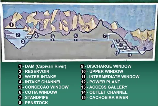
twenty-two years later, in the late 1970s, this plan was put into practice: with over 250 MW, it was the most powerful power plant in the state then, supplying electricity to the capital, Curitiba, which for decades faced difficulties resulting from an irregular supply and from several blackouts in the period dur-ing which the CFLP utility, owned by the american Foreign Power Company (aMFoRP), was in charge. the dam is located on the “First Paraná Plateau”, 830 meters above sea level, and a significant part of the natural flow of the dammed-up Capivari river runs through a 14 km-long horizontal underground tunnel that cuts through the rocky heart of serra do Mar and ends in a concrete penstock more than one kilometer long, with a steel-shielded final half feeding an underground powerhouse that is described below (Figure 2)
1 - DAM (Capivari River) 2 - RESERVOIR
3 - WATER INTAKE 4 - INTAKE CHANNEL 5 - CONCEÇÃO WINDOW 6 - COTIA WINDOW 7 - STANDPIPE 8 - PENSTOCK
9 - DISCHARGE WINDOW 10 - UPPER WINDOW
11 - INTERMEDIATE WINDOW 12 - POWER PLANT
13 - ACCESS GALLERY 14 - OUTLET CHANNEL 15 - CACHOEIRA RIVER
Figure 2 – Painted panel of a cross section of the Capivari–Cachoeira system (photo by Luci-ana Maria Kalinowski within a CoPeL facility, Paraná, July 24, 2009).
increased to 260 MW in 1999. an additional 7 km stretch was excavated in the rocks beyond the water intake tunnel: two “windows” or vents were opened in it that reach up to the surface of the mountain range. other secondary tunnels were excavated in the stretch where the penstock is located: one for installing the standpipe (meant to reduce the overpressure effects in the tunnels), one for installing the safety butterfly valve (automatically stops the water flow in case of emergency), and three other “windows”.
among the several difficulties faced during the construction of the power plant, special mention should be made of violent decompression phenomena, resulting generally from dynamite explosions, which in some cases led to a sud-den rupture and shattering of the rocks on the excavation walls and even to the collapse of large sections of open tunnels.6 during our survey, we did not have
access to the records of victims of these work-related accidents, but photos from back then show very poor working conditions. it is known that the health and safety at work standards were less stringent and comprehensive than today. both Personal Protective equipment (PPe) and Collective Protection equipment (CPe) were generally not used. because of the extreme heat and the poor and/ or non-existent ventilation in the tunnels, workers used to wear only shorts, boots and inadequate helmets (eletrocap, 1967).
on a visible wall in the pedestrian access to the underground power plant, the engraved phrase confirms the loss of human lives with the following words:
“On this bronze plate nailed to the rock that embraces in its fold this power-house, we pledge our debt of gratitude to the anonymous heroes we miss, who lost their lives working in an idealistic and selless manner for the development of Paraná and Brazil. COPEL – January 26, 1971”.
the powerhouse lies in the heart of the serra do Mar Mountain Range: there are three adjoining caves, the largest of which is 82-meter long, 15-meter wide and 25-meter high, housing the four turbo-generator groups of 65 MW each and the control room. the gallery enabling the access of pedestrians and materials to the caves is 1,100 meters long and 6.4 meters wide, through which run the high voltage cables that carry energy from the three-phase transformers of 70 Mva each (13.8 kv to 230 kv) to the substation. Four transmission lines connected to CoPeL’s interconnected system (2000) run from this gallery: two to Curitiba and two to the coastal cities.
of which for employees of the state company, thirteen for outsourced employ-ees, three for the Parents and teachers association of the hiram Rolim state school, eight for a transit hotel, and seven are empty, apart from a club. the school in the workers’ village was assigned to the state education secretariat (seed) through a technical Cooperation agreement (CoPeL, 2000).
In the Capivari River reservoir, the usual impacts, in addition to seismicity
in the late 1969s, CoPeL had to expropriate about 20km2 of land on the plateau to create the dam construction site and water intake structure, as well as to build a residential village of eighteen houses. in 2000, five of these houses were occupied by CoPeL staff, two by outsourced employees, one by the For-est Guard, and the remaining ones were lent to be used as a field headquarters for the workers’ association – a quite common practice among electricity utili-ties. the company requested the then dneR to take on the task of relocating a seven-km stretch of the bR-116 highway (Regis bittencourt), including the construction of a two-lane bridge over a creek in the dam. in practice, the Paraná state company delegated much of its responsibility to a contractor, ele-trocap, which took charge of implementing these measures, beginning with land reorganization and the removal of at least four hundred rural properties and, officially, eighty families living there.7 some of these residents allegedly used the
compensation money to buy rural land close to the dam, but since brazil was in the midst of the dictatorial regime at the time, it is likely that many social rights were violated by the companies and that problems were not even made public.
or the Conama Resolution defining Permanent Protection areas (aPP) as any area within 100 meters of artificial lakes.
Fishing activities are one of the sticking points in the environmental management of dams. in the case of Capivari, these activities are not controlled, except upon complaint, and overfishing is a common practice, with the use of nets and other prohibited methods. the fish diversity in the basin is poorly known; what is known is that minnows and discus (native) are the most nu-merous species and that exotic species such as tilapia, black-bass and carp were introduced by the company. in the 1970s, following recommendations of the then Fishing development agency (sudePe) and the example of other power utilities, CoPeL embraced the trend toward fishing farm and indiscriminate fish stocking, with the aim of mitigating or offsetting the impacts caused by the creation of the reservoir.8
after the flooding of the dam, tremors began to be felt in the surround-ings, resulting in cracked window panes in the camp’s houses, and were also observed later in the powerhouse at the foot of the mountain range, 14 km from there. this is a common phenomenon in many dams around the world: it is called “reservoir-induced” seismic activity (sevá, 2008). in this case, there was a complicating factor of the tunnels being excavated during the construction phase. although tremors were not recorded on the seismograph, the workers in the power plant wrote down the days of these events and their effects, and this information was then compiled by researcher berrocal et al. (1984): there was a total of forty events from February 1971, when the dam was close to peak sum-mer levels, to 1977, of which 80 percent took place in the first two years. Most tremors were felt in the lower part, in the powerhouse, residential village and in the surroundings, reaching intensity iv and, in some rare cases, v-vi on the Modified-Mercalli scale. Furthermore, according to geophysical reports by the technological Research institute of são Paulo that were mentioned by one of the authors in a recent paper on the project for building the tijuco alto Power Plant on the Ribeira River, the land in this basin is historically prone to natural earthquakes, and this propensity increases as a result of the characteristics and weaknesses of the karst subsoil in several sections, with underground caves and rivers (sevá Filho et al., 2007).
in the embankment (sealing and containment), which was prone to erosion be-cause of changes in the reservoir water level. in december 2006, a court ruled that dnit was to pay compensation to the victims’ families.9
Downstream the dam in Capivari: many kilometers of a dry river and
some poorly explained loods
two types of problems have been observed downstream the dam in the Capivari River:
1) Most of the time, the first kilometers of the riverbed remains dry, stones be-come exposed, and the river’s ancient flow is witnessed by water puddles only. the explanation is obvious: the flow diverted to the coastal basin, which corresponds to the swallowing capacity of the power plant turbines, can reach up to 38 m3/s, a
sig-nificantly disproportionate rate for a small river. the company recognizes this issue in a report (CoPeL, 2001): “as the machine swallowing capacity is larger than the long-term average flow at the site (19 m3/s) and the reservoir has a large working
volume (156 x 106 m3), much of the inflows to the reservoir are transported to the
Cachoeira River. From July 1971 to december 1999, 85.7 percent of the inflows were transported to the Cachoeira River”. Currently, any internet user can see the consequences by looking at satellite images from, for example, Google earth.
2) in rainy periods, the company is forced to open the spillways, leading to exceptional flows and floods downstream. For this reason, CoPeL has been accused of being responsible for the floods and their consequences for different municipalities in the Ribeira valley. on this issue, it is worth presenting some contradictory, well-reasoned arguments. For example, during the heavy rains in the fall of 1983 that led to several disasters across the southeast and south re-gions, the mainstream media reported that the flood in Ribeira left three people dead and 12,500 others homeless in the municipalities of Registro, iporanga, eldo-rado, Ribeira, sete barras and iguape, apart from significant losses in banana planta-tions.10 another news story recognized an aggravating effect, also as a result of the
operation of Cba’s power plants on the Juquiá river, which contributes mainly to the flooding in the cities of Juquiá, on the lower river, and Registro, located below the confluence of the two rivers. “this year, the floods were more severe due to the contribution of the dams in the Capivari-Cachoeira system in Paraná and of the power plants of the brazilian aluminum Company at the headwaters of the Juquiá River”. in the 1990 floods, the mainstream media once again indicated problems in the CoPeL system, not even mentioning the possible responsibility of Cba’s power plants.
The intrinsic problem of the water low divertion: the increased low to the
Cachoeira River, and the levees in the Antonina Bay estuary
performance. the river has obviously become another hydrological entity, with the increased flow forcing the enlargement of the old pipeline and causing bank erosion. What is even worse is that, apart from the seasonal variation in the river’s natural flow, now there is also the operational variation (i.e., determined by commercial criteria for energy sales) of the water flow discharged into the Cachoeira River after the turbines of the Parigot de souza Power Plant. this changes almost everything, starting with the micro- and macroscopic aquatic life and sediment transport.11 these water flows are discharged into an area
rela-tively close to the lower river and its estuary, resulting then the siltation of the riverbed and the erosion of banks. the probable consequence is the progressive levees of many parts of the antonina bay, where one can see forming shoals and even new islands. this problem ultimately affects the movement of vessels on account of reduced channel depth – in front of the náutico Club, for example, this depth appears to have decreased from 7 to 4 m in the last two decades.12
Concluding message: denial of the transposition between basins and the fearful continuation of the construction work surge
environmental Licensing was not a mandatory requirement when the Capivari–Cachoeira system was built. however, with the passing of Cona-Ma Resolution 001/1986 and, particularly, the introduction of article 225 in the 1988 Federal Constitution, this requirement became mandatory for new projects. through resolutions and additional instructions, the existing projects would have to be “licensed ex-post”. the power plant concession granted to CoPeL expired in 1995, and yet no measures had been taken to regulate en-vironmental aspects, which only happened in 1999 by means of an agreement with the Paraná environmental institute (iaP). the company then requested an operating License for the power plant and, to this end, it would need to submit an environmental impact report pursuant to Paragraph 5, article 12 of ConaMa Resolution 006/87. on september 17. 1999, CoPeL applied for the operating License for the Parigot de souza Power Plant with the iaP and, on the same day, the institute carried out an inspection. surprisingly, the state agency found that the power plant site (bairro alto in antonina) and its surroundings were “stable” because of the environmental recovery plan imple-mented by CoPeL.13 in the dam, the iaP found five cases of slope landslides,
probably due to the effect of ripples and water-table oscillations resulting from the operational drawdown of the dam’s water level, and called upon CoPeL to prepare an action plan to prevent overfishing, illegal deforestation, slash-and burn practices, and irregular buildings in the region (CoPeL, 2000).
a more rigorous analysis would show that this could be seen as an “insti-tutional schizophrenia”, because:
2) several documents submitted by CoPeL, by the Water Resources de-velopment and environmental sanitation agency (suderhsa) and even by iaP do not consider the Cachoeira River as part of the power plant’s water body, ignoring the deviation of a significant water flow between the two basins;
3) the environmental agency ignores all sorts of influence from the tur-bined flow discharged into the Cachoeira River, its estuary and the antonina bay, as well as the problems faced by residents and landowners (usually small) who live off agriculture, fishing and animal husbandry resulting from the in-creased flow of the Cachoeira River, such as water turbidity, erosion, and loss of riparian vegetation and productive land.
Finally, the agency does not even mention the use of the bay for recreation and tourism purposes, much less for navigation and operation of maritime ter-minals.
in the Ribeira basin, another power plant is being built on the same Capi-vari River in the state of Paraná, an old project called salto do inferno. other 26 power plant projects were studied and inventoried in five rivers, including four medium-size projects in the main river, Ribeira de iguape, the best known of which is the tijuco alto Power Plant, with a dam more than 120-meter high located a few kilometers from the cities of Ribeira (sP) and adrianópolis (PR). should the criteria used so far and the idealized images continue to prevail, the future outlook is alarming. the land of this two-state basin is being degraded and its rivers are disappearing, like so many others throughout brazil.
notes
1 Please see <http://www.socioambiental.org/prg/rib.shtm> e <http:// www.preac. unicamp.br/novoquilombolas/evento/barragem.html>.
2 sources: 1) nomenclature and location in accordance with the hydroelectric Po-tential information system (sipot) developed by eletrobrás. 07/2005. available at: <http:// www.eletrobras.gov.br>. accessed 20 aug. 2006. 2) order n.141 of Janu-ary 24, 2007 – aneel. 3) amaral & Prado (2000). 4) CBA Power Plants. available at: <http://www.aluminiocba.with.br/workers’party/plants.php>. accessed 10 aug. 2009.
3 apart from the two largest flow reversal projects in the serra do Mar Mountain Range, special mention should be made of the small Macabu-Macaé system in the mountai-nous region of Rio de Janeiro: through a five-km tunnel, a dam in the Macabu River in the municipality of trajano de Morais feeds a small 11-MW power plant completed in 1950 at the foot of the mountain range, where it empties the water into the são Pedro River belonging to the Macaé River bay. a serious environmental consequen-ce of this project is that the Macabu River, which had much of its flow diverted to another basin, is the main responsible for the freshwater volume in the Feia Lagoon, the largest one in the entire lagoon system on the coastal region of Rio de Janeiro (embrapa, 2004).
www.aneel. gov.br/aplicacoes/audiencia/arquivo/2005/004/contribuicao/light_ anexo_i.pdf>. accessed 12 Feb. 2010.
5 “the Guandu River, which under natural conditions would have a flow rate of about 25 m³/s, receives an average contribution of 146 m³/s from the Paraíba-Piraí detour and of 10 m³/s from the tócos-Lajes detour. this additional contribution allowed Cedae to build the Guandu River Water treatment station, which began opera-tions in 1955 and currently processes 47 m³/s of water to serve the population in the metropolitan region of Rio de Janeiro. the obligation to keep the flow in the Lajes Complex power plants at levels consistent with the catchment needs of the Guandu River Water treatment station is part of the electricity concession contract granted to the company”. note: same source of previous note.
6 these risks were partly minimized by using anchor bolts, totaling 50,000 parts and about 4,750 metal straps – as is done in underground mining (CoPeL, s. d.).
7 according to newspaper O Estado de São Paulo, July 14, 1970.
8 More detailed surveys carried out in this and other dams in the state found that the number of species introduced is high, that the density of introduced species is very low, and that the repopulation of the Mourão and Capivari reservoirs did not produce the expected fishery yield, contributing less than 5 percent of the full catch (nupelia/ ueM, 2000).
9 “Queda da ponte sobre rio Capivari-Cachoeira: responsáveis são alvo de ação de im-probidade administrativa”; december 5, 2006. available at: <http://www.pgr.mpf. gov.br/noticias/noticias-do-site/patrimonio-publico-e-social/queda-da-ponte-so-bre-rio-capivari-cachoeira-responsaveis-sao-alvo-de-acao-civil-publica>. accessed 14 Feb. 2010.
10 according to newspaper Folha de São Paulo, June 2, 1983. O Estado de São Paulo, July 3, 1983. 11 according to the historical series of the former national Water and electricity depart-ment (dnaee), the average flow rate of the Cachoeira River in the 1931-1966 period reached 21.7 m3/s, while the average flow of the Capivari River, according to data from CoPeL for the 1931-1992 period, was 17 m3/s (Lambertucci, 1996). a study carried out by odreski et al. (2003) comparing bathymetric surveys in the antonina bay between 1901 and 1979 indicated a sediment volume of about 60 x 106 m3, equivalent to a sedimentation rate of 2.6 cm/year.
12 the siltation of the antonina bay draws the attention of the local population, resear-ches and companies. the “Ponta do Félix Port terminals – tPPF” launched the Con-taminant, siltation and dredging Program (Cad) to simulate rainfall, flows and di-fferent behaviors of rivers and estuaries. CoPeL’s environmental Coordinating body, concerned about the accusations of responsibility for the impact of its power plant, commissioned a project from state laboratory Lactec (boldrini, 2007). Moreover, bandeira (2007), branco (2004) and odreski (2002) analyzed the morphological and sedimentological changes in the Cachoeira River estuary since the 1950s, concluding that the power plant’s discharge was directly responsible for such changes.
References
advR. development agency for the Ribeira valley/Guaraqueçaba Mesoregion.
Im-passes e desaios da Mesorregião Vale do Ribeira / Guaraqueçaba. Curitiba, 2002. aLbeRti, s. M. et al. Metodologia desenvolvida para a remoção de “fouling” no sis-tema de resfriamento das unidades geradoras da usina Governador Parigot de souza – us/GPs. eletroevolução, n.3, 2nd quarter of 1995. in: CoPeL Geração – GeR. Relatório Ambiental da Usina Hidrelétrica Capivari. anexos. Curitiba, 2000.
aMaRaL, C. a.; PRado, F. a. a. (org.) Pequenas centrais hidrelétricas no Estado de São Paulo. são Paulo: Páginas & Letras editora e Gráfica, 2000.
aRRuda, G. Rios e governos no estado do Paraná – pontes, “força hydraúlica” e a era das barragens (1853-1940). Varia História, v.24, n.39, Jan/Jun 2008.
bandeiRa, v. P. s. Licenciamento ambiental e a categoria de totalidade: um estado de caso. in: boLdRini, e. b.; soRaes, C. R.; PauLa, e. v. (org.) Dragagens
por-tuárias no Brasil: licenciamento e monitoramento ambiental. antonina: Government of the state of Paraná; sema/PR; ademadan; unibem. 2007.
beRRoCaL, J. et al. Sismicidade do Brasil. são Paulo: instituto astronômico e Geof sico. university of são Paulo and national nuclear energy Commission, 1984.
bitaR, o. Y. Mineração e usos do solo no litoral paulista: estudo sobre conflitos, altera-ções ambientais e riscos. Campinas, 1990. thesis (master) – Geosciences institute, state university of Campinas.
boLdRini, e. b. Programa Cad: Contaminantes, assoreamento e dragagens no estuário de Paranaguá. in: boLdRini, e. b.; soRaes, C. R.; PauLa, e. v. (org.)
Dragagens portuárias no Brasil: licenciamento e monitoramento ambiental. antonina: Government of the state of Paraná; sema/PR; ademadan; unibem, 2007.
bRanCo, J. C. Alterações morfológicas na foz do rio Cachoeira, Estado do Paraná, com base na análise da evolução das unidades de planície de maré. Curitiba, 2004. thesis (master) – Geology deparment, Federal university of Paraná. CoPeL Geração – GeR. Relatório Ambiental da Usina Hidrelétrica Capivari. Curitiba,2000.
_______. Generation engineering agency – Gesen. Inventário hidrelétrico da bacia do rio Capivari - Estado do Paraná. Curitiba, January 2001. CoPeL. Usina Governador Parigot de Souza. s. d.
eLetRoCaP. Central elétrica Cachoeira s/a. Aproveitamento Capivari--Cachoeira. 4v. June 1963-May 1967.
eMbRaPa. Diagnóstico do meio físico. Bacia Hidrográica do Rio Macabu. 2004. avai-lable at: <http://www.cnps.embrapa.br/solosbr/pdfs/doc63_2004_riomacabu. pdf>. accessed 2 Feb. 2010.
Kalinowski, L. M. A região do Ribeira do Iguape (Paraná/São Paulo) e a hidreletricida -de. elementos para uma revisão crítica. Campinas, 2011. thesis (Phd) energy system Planning interdisciplinary area, FeM/unicamp.
LaMbeRtuCCi, J. L. Diagnóstico preliminar do estado de conservação da microbacia hidrográica do Rio Cachoeira. Maringá, 1996. 67p. thesis. Geography Course, Federal university of Paraná, Curitiba.
ictio-fauna dos reservatórios Capivari, Guaricana, alagados, Rios dos Patos, Fiú, Mourão, vossoroca, Cavernoso, Marumbi, Chopim i, Melissa e salto do vau. In: Relatório Am-biental da Usina Hidrelétrica Capivari. anexos. CoPeL, 2000.
odResKi, L. L. R. et al. taxas de assoreamento e a influência antrópica no controle da sedimentação da baía de antonina - Paraná. Boletim Paranaense de Geociências, n.53, p.7-12, 2003.
odResKi, L. L. R. Evolução sedimentar e batimétrica da Baía de Antonina – PR. Curitiba, 2002. thesis (master) – Geology department, Federal university of Paraná. sevÁ FiLho, a. o. et al. Parecer independente sobre o licenciamento ambiental do projeto da Hidrelétrica Tijuco Alto, no rio Ribeira de Iguape (Paraná - São Paulo) e sobre seus riscos para o povo e sua região. são Paulo: isa, mar. 2007.
sevÁ, o. estranhas catedrais. notas sobre o capital hidrelétrico, a natureza e a socieda-de. Revista Ciência e Cultura, temas e tendências. sbPC, year 60, v.3, p.44-50, Jul-sep. 2008.
AbstrAct – the image of the Ribeira do iguape basin is usually linked to environment
protection, to natural caverns and to traditional people communities (descendants of runaway slaves, indigenous peoples, fishermen). this paper draws another diagnosis, lightening up important geo-economic issues, such as mining fields, plantations and hydraulic works. the main river has not yet been dammed for the hydropower plants located in its tributaries, featuring an amount of 540 Megawatt capacity. the most im-pressive one, called Capivari– Cachoeira system, was built forty years ago and is based on a flow derivation from the high Ribeira basin to the coastline of the Paraná state. its consequences are negative downstream the Pardo and Ribeira rivers in the são Paulo state, also affecting the antonina bay on the other side. these damages were not recog-nized during the licensing process for this power plant. the environmental degradation in this region will only worsen if some other hydroelectric projects are implemented in the future.
KeywOrds: Ribeira do iguape, hydropower plant, Riverflow derivation, environmental
impacts, Reservoir-induced seismicity.
A. Oswaldo Sevá Filho holds a doctorate degree in human Geography (université de Paris-i). he is currently a professor at the energy department, Mechanical engineering Faculty, and in the doctoral Course in social sciences at the Philosophy and human sciences insti-tute of the state university of Campinas. @ – [email protected] / [email protected]
Luciana Maria Kalinowski is an electrical engineer and professor at the Federal technological university of Paraná, Curitiba. she holds a master’s degree and is a doctoral candidate in electricity system Planning from the Mechanical engineering Faculty, state university of Campinas. she is currently a scholar from Capes. @ – [email protected]