Discovery and retrieval of Geographic data using Google
Discovery and retrieval of geographic data using Google
Dissertation supervised by
PhD Rafael Berlanga Llavori
ACKNOWLEDGMENTS
My utmost gratitude goes to Professor Rafael Berlanga, Sven Schade and Professor
Marco Painho for their supervision, advises and support. Really special thanks to Eva
and my family for their unconditional and continuous support, motivation and love.
Also thanks to my master colleagues for their friendship despite the distance, the
language or the culture. Finally I would like to thank professors Joaquin Huerta and
Discovery and retrieval of geographic data using Google
ABSTRACT
The growth of content in the Internet makes the existence of effective ways to retrieve
the desired information fundamental. Search engines represent applications that fulfil
this need. In these last years it has been clearly increased the number of services and
tools to add and use the geographic component of the content published on the World
Wide Web, what represents a clear trend towards the so called GeoWeb. This web
paradigm promotes the search of content based also in their geographical component.
Here is presented a study about the possibilities of using the different services and
tools that Google offers to discover and retrieve geographic information. The study is
based in the use of Keyhole Markup Language files (KML) to express geographic
data and the analysis of their discovery and indexing. This discovery process is done
by crawlers and the study tried to obtain objective measures about the time and
effectiveness of the process simulating a real case scenario. In the other side the
different KML elements that could allocate information and metadata were analyzed.
In order to better understand which of these elements are effectively used in the
indexing process a test data set composed by KML files containing information in
these elements were launched and the obtained results analyzed and commented. With
the experiment’s results the use of these services and tools are analyzed as a general
solution for Geographic Information Retrieval. Finally some considerations about
KEYWORDS
Geographic Information Systems
Geographic Information Retrieval
Keyhole Markup Language
ACRONYMS
KML – Keyhole Markup Language
WWW – World Wide Web
OGC – Open Geospatial Consortium
WMS – Web Map Service
WFS – Web Feature Service
Table of Contents
ACKNOWLEDGMENTS ... i
ABSTRACT... ii
KEYWORDS...iii
ACRONYMS... iv
INDEX OF TABLES... vi
INDEX OF FIGURES ...vii
1. INTRODUCTION ... 1
1.1 Motivation ...1
1.2 Problem Statement ...2
1.3 Research Questions and Goals ...2
1.4 Methodology...3
1.5 Structure of the Thesis...4
2. BACKGROUND ... 5
2.1. Study Context ...5
2.2. Google Geo Services ...8
2.3. Content Publication ... 11
2.4. Keyhole Markup Language... 20
2.4.1. Past, Present and Future...20
2.4.2. Structure and Elements...22
3. METHODOLOGY...29
3.1. Introduction ... 29
3.2. Content Publication ... 29
3.3. Content Indexing... 30
3.3.1. Standard KML Elements...32
3.3.2. Snippet KML Element...32
3.3.3. NetworkLink KML Element ...33
3.3.4. ExtendedData KML Element ...33
3.3.5. Test Data Sets ...35
4. EXPERIMENT ...37
4.1. Introduction ... 37
4.2. Results ... 38
5. DISCUSSION OF RESULTS...41
5.1. Time ... 41
5.2. Effectiveness ... 41
5.3. Elements for the Indexing... 44
5.4. Nontechnical Aspects... 45
6. CONCLUSIONS AND FUTURE WORK...48
6.1. Conclusions... 48
6.2. Future Work ... 50
INDEX OF TABLES
TABLE 1: KML FEATURE ELEMENT DETAILS... 25
TABLE 2: KML NETWORKLINK ELEMENT DETAILS. ... 25
TABLE 3: KML PLACEMARK ELEMENT DETAILS. ... 25
TABLE 4: KML CONTAINER ELEMENT DETAILS. ... 26
TABLE 5: KML FOLDER ELEMENT DETAILS... 26
TABLE 6: KML DOCUMENT ELEMENT DETAILS. ... 26
TABLE 7: KML GEOMETRY ELEMENT DETAILS. ... 26
INDEX OF FIGURES
FIGURE 1: GOOGLE MAPS IS THE WEB‐BASED MAP SERVICE OFFERED BY GOOGLE. ...9
FIGURE 2: GOOGLE EARTH ALLOWS THE VISUALIZATION OF THREE‐DIMENSIONAL EARTH SURFACE. ... 10
FIGURE 3: BARRY HUNTER'S DIAGRAM REPRESENTING ALL THE POSSIBLE OPTIONS TO MAKE AVAILABLE GEOGRAPHIC CONTENT USING GOOGLE'S SERVICES AND TOOLS... 13
FIGURE 4: OVERVIEW INFORMATION AVAILABLE ON GOOGLE WEBMASTER TOOLS... 16
FIGURE 5: SITEMAP.XML FILE'S DETAILS DISPLAYED USING GOOGLE WEBMASTER TOOLS... 18
FIGURE 6: KML ELEMENTS HIERARCHY... 23
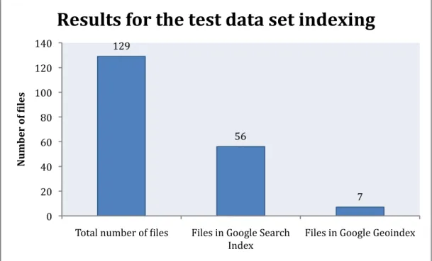
FIGURE 7: RESULTS FOR THE TEST DATA SET INDEXING. ... 38
1. INTRODUCTION
1.1 Motivation
In the last years some of the biggest companies in the Internet have released services and tools to visualize geographic content entering in this way into the Geographic Information (GI) market [1, 2, 3]. Among these companies it can be found Google, Yahoo or Microsoft, Some of the companies owning the most used and well known search engines. This could be the reason why their mapping applications are not limited to visualize geographic content but they can also be used to search it. In some cases, like in the case of Google, the users can also create and share with others their own geographic content [4, 5].
The users have several publication options in order to have their content appearing in the search results for other users that are looking for some specific geographic content. These options are not much different of the ways the users already have to get their websites appearing in the search results. These goes from using directly Google’s services like Google Maps [1] or Google Earth [6] through their related websites to simply publish the appropriate files in a publicly accessible server and wait till the search engines systems reach the content. This last publication method represents probably the easiest way to share any content. It also implies a clear advantage concerning time and simplicity in comparison with other methods of publishing geographic content such as the actual catalogues [7] like GeoNetwork (http://www.geonetwork.net), where the users usually need to upload to a given server the geographic content.
Moreover not only the publication model is easy and accessible but also the way the creators can describe their content. Currently, when somebody wants to publish and share geographic content seems imperative the use of metadata [8] to give information about the content itself. In most of the cases, this metadata is the information used in the searches or in other words, the place where looking for the information that matches the search parameters. Now, with the new services offered by Google and the other companies, seems that the user does not need to create metadata anymore and it is the information in the same content’s file the one used in searches. Sometimes this information seems reduced to a simple textual description or free text. This also could be observed as an advantage in front of the actual formal methods for metadata creation that implies the creation of a long list of attributes, where some of them usually finish being irrelevant for the final user or for their searching.
Another important aspect is that most of the companies that offer these kind of services act globally, analyzing a vast number of sites and resources on the whole World Wide Web (WWW or simply the Web). These companies are supported by huge technical infrastructures highly worth and hard to imitate.
complement or alternative to the actual methods for sharing geographic information. Among all these companies Google seems the one that offers more services, with web based, desktop and mobile applications and for sure is one of the most used. For these reasons, Google has been used as use case for the following study. These services allow the use of different file types, however the most promising and probably used is the Keyhole Markup Language (KML) [9], recently declared as an Open Geospatial Consortium (OGC) [10] standard. This format has been analyzed and used along this study as standard for representing geographic content.
1.2 Problem Statement
Although these services could represent a simple way of publishing and retrieve geographic information these could not necessarily represent an effective solution. An analysis on different parameters such as the process performance and effectiveness must be performed.
Moreover the information that these systems use as basis for the searches should be discovered and analyzed. At the same time and because a great effort has been invested in creating successful ways of explaining the geographic content, most of times using some metadata standards, its integration and exploitation using these services should be explored.
1.3 Research Questions and Goals
In order to address these issues the following questions will try to be answered in this study:
(1) How much time does it take to get some geographic content indexed for a standard use case?
In order to be considered an effective solution, the geographic content not only should be correctly indexed but also it must be indexed in reasonable time.
(2) Which information is relevant within a file for its correct indexing?
The KML format allows structuring the information in different ways. The knowledge about which parts of those files are meaningful for the indexing process could provide useful information about how to design them to increase their possibilities to become successfully indexed.
(3) Do the elements within a file where the information is placed affect the file’s indexation?
Continuing with the previous question, a good file design could improve its indexing but it is fundamental also to know if placing the information in other places could derive in a failure.
A lot of geographic information with its correspondent metadata already exists. If it is finally demonstrated that these services offer an effective method for discover and retrieve geographic content then it would be also interesting how the existing geographic content and more precisely their metadata could be adapted to use these services.
(5) Could this way of publishing be a general solution for discover and retrieve geographic information? Could it replace other techniques already in use?
Based on the answers to the above questions, the use of the services provided by Google as a general solution could be analyzed and also a comparison with actual methods of content publication such as catalogues performed.
1.4 Methodology
For this study KML files have been used to express geographic data. The decision of using KML for the study has been taken considering its recent standardization by the OGC and also because Google specially indexes this type of files. It is also important to make note of all the possibilities this flexible format represents to express and visualize geographic information.
To answer the research questions the study has been focus on three main aspects. The first one is the time the system takes to crawl and index the content since its publication in the server. This measure could demonstrate if Google offers and effective solution with acceptable performance. Secondly, the number or percentage of files that are finally indexed from the whole set of test files released in the experiment. It seems that not all the files become crawled by Google and even less finish in the index for some reason. If this quantity demonstrates to be too small probably the system cannot be considered effective as a general solution. Finally which parts within a KML file are analyzed by Google’s search engine. If these elements were discovered then it would be easier to insert the correct information in the right place for an effective indexing. The study of the KML elements includes also the use of existing metadata inside a KML file and all the different elements that seem suitable to store significant information.
Google seems to divide into two different indexes the information used by the traditional web search service from the other specifically geographic services. The web search service allows the user to search geographic content expressed in KML as well. At the same time the geographic content in the other index is most of the times also represented in KML. Although this is none of the study’s objectives, the results obtained using one or another index could be contrasted.
An experiment to analyze the above explained aspects was conducted. A real case scenario was simulated and the Google’s advices about publishing geographic content followed [11].
within the files. The use of the different KML elements has been based on their functionality considering those of them suitable to store representative information. These test data sets could be derived into two main groups. The first one, make use of the same information stored in different places within a KML file, all in the same position. The indexing of these files could give an idea of which KML elements are used in the process. The second set was composed by different files with different information in different elements within the file and also in different locations. The reason why a second set was used is to avoid some situations that could affect the correct indexing of the files such as the content duplication.
To obtain the different measures about performance, effectiveness and indexing of the files different queries were used in the different searching services offered by Google. Then the time spend, the number of files appearing in the results for these queries and the files that were successfully indexed were recorded and analyzed.
1.5 Structure of the Thesis
2. BACKGROUND
2.1. Study Context
Since the birth of the World Wide Web in 1989 the quantity of users has been radically increased [12]. With the number of users reaching extraordinary high quantities also the quantity of information, services and other resources available to them through the Internet have experimented a huge growth. This high number of resources transforms the task of finding any of them into a difficult one, unless the users know exactly where these resources can be found. In this context it is not difficult to guess that a tool capable of helping users in finding what they are looking for would be extremely useful. In the first stages of the WWW list of categorized directories exist in order to address somehow the searches and help the users to find the resources based on their theme. However it is with the appearance of the well-known search engines, when that tool intended to help the user appears. This search engines simplify the complicated task of finding any resource in an ocean of information by, most of times, just typing the terms that better match or describe the content sought. A tool that simplifies such a tedious process is destined to succeed. This is one of the reasons why nowadays names such as Google, Yahoo or Microsoft are not unknown for the vast majority of the Web’s users. There are more companies offering search engines as well, however these are some of the companies that own the most used search engines in the whole WWW recording millions of visits per day [13].
In the last years the way the people use the WWW has evolved. At the beginning the Web could be considered as a unidirectional way of content service. In this scene the producer generates content directly consumed by users. Nowadays, this Web users are not merely content consumers but also producers deriving in a bidirectional schema of content production and consumption. The Web 2.0 [14] could be described as a change in the technology and design on the actual Web focused mainly to improve its functionality, communications, information sharing, creativity and collaboration along it. Everyday more and more people write about their experiences or knowledge in their blogs, share their last trip photographs using their online photo album or create social or professional networks through different web sites. All these facts derive in an impressive growth in the quantity of content publicly accessible through a web browser. It seems logical to think that at the same time the quantity of content increases, the act of searching and discovering specific information among that content becomes more difficult. Then it also seems clear the importance of effective searching tools.
for example HTML web pages. Among other things, this would allow the search of content based on the content’s location. The Neogeography it is a term used to describe the use of geographic information related techniques by non-professional users or for personal or community purposes. In any case this usage is done usually through web browser and give the opportunity for creating geographic content to a broader public. Both cases suggest an increase of geographic information publicly available on the web. As it already happened with the textual content expressed in simple HTML, effective techniques to find this content will be required.
The Internet and the Web’s evolution inevitably have affected and still affects other fields and not only those directly related with computing. In general, apart of the appearance of the Neogeography and the GeoWeb concepts, the Geographic Information (GI) has evolved also using for its own profit the advances that the Web and Internet’s evolution has brought. Nowadays it is common to hear terms like Spatial Data Infrastructure (SDI) [12], read about interoperability studies like the one represented by GEOSS [17], or study new standards and services like the ones defined by OGC. All of these topics are related with the use of the Web to transmit, create or share geographic content. As already mentioned this evolution brought also new standards like the OGC specifications, most of them based also on the Web as the main transmission medium. Several of these standards like the Web Map Service (WMS) [18], Web Feature Service (WFS) [19] or Web Processing Service (WPS) [20] are becoming or already are widely spread used. Currently it is possible to convert the web browser into a GIS application using remote applications and services such as WMS, WFS or WPS. This way of working represents the also known thin clients, and directly eliminates the need of using desktop GIS applications or heavy clients by the end user. It seems that the improvement carried by the Web and the Internet evolution has directed the GI field’s evolution towards an intensification in the use of distributed resources like remote services and data against the traditional use of desktop applications with locally stored data.
This movement from the desktop to the network can be also seen on the constant release of new web services related with the GI field and also on the continuous emergence of new SDI projects. One example of these projects can be found in the European INSPIRE Directive [21]. Defining an SDI is a task that varies with the context. Some people could consider an SDI as an infrastructure that interconnects data and software in an organization. Somebody else could add that an SDI is much more than the technical part and includes also the rules that compose a work framework that defines how to work in that organization. What it is probably true in any context is that one of any SDI major goals is to allow the sharing and collaboration between their users. This is based usually on accepted standards including services for sharing geographical information between different partners using a key element that keeps all the parts in a SDI connected, the metadata.
the model to express geographic information. It defines a set of mandatory and optional fields and allows extensions to adapt it to specialized and specific situations. These metadata standards have primarily been used to help in understanding, comparing and interchanging the content of the dataset described. Among other functions metadata standards are primarily concerned with the discovery of data [23].
The study on metadata is an active field where new studies are constantly presented. In the last years some critical studies about the actual metadata standards and their use have appeared as well. Goodchild [24] argues that the actual metadata for expressing data quality is producer-centric and requires a change towards an user-centric model. In his paper Goodchild enumerates a set of problems in the actual use of metadata for data quality and talks about the need of a second generation of standards. Bulterman [25] goes further and makes an analysis about the current utility of metadata from a multi purpose point of view. In his study he concludes that maybe metadata is not as needed as it could be considered: “The point is this: People do not need to add metadata to text documents if documents are processed electronically. Experience has shown that the contents of text documents can be mined directly using a host of existing information retrieval technologies and that metadata descriptions are often superfluous.”
Actually some search engines already perform this file content processing. For instance, Google searches and indexes files expressed with different types. This number of types is continuously being increased adding new ones. Currently users can search content into file types such as Adobe Acrobat PDF [26], Shockwave Flash [27] or Microsoft Word [28]. Maybe saying that metadata is not needed anymore is saying too much, at least for all type of files and users. However it is true that not all users need all the information provided by conventional metadata and just base their search on the content itself and not in the information about it. An example could be found in the case where a user is looking for a given PDF document and that user is only interested in the document’s content or text. No other information about the document such as author, creation date or even license that could be found in some of the metadata standards are necessary for all users. However there could exist also the case of that specialized user looking for a PDF document within specific properties such as author, license and more. In this case probably the information included in the document content or text is not enough to satisfy the search requirements and again the use of metadata that follows the document is required. These points of view could also be applied to the GI field. Most of the studies about searching in this field are based on the use of metadata standards such as the ISO19115.
in all their datasets could be a standard practice strictly followed. However for a sporadic creator of geographic content adding the right information for all the fields required by the ISO19115 seems an easy to ignore task. Probably simplifying the metadata creation process, limiting this to a simply but complete description and improving how the information retrieval system works could represent a solution. In the already coming GeoWeb most of the content will be produced by non-experts and simple ways to add metadata to the geographic content will be required.
Some of these services are the ones offered by Google that we will call Google Geo Services in the rest of the document. These free services include three-dimensional viewers like Google Earth (http://earth.google.com), web based and two-dimensional viewers like Google Maps, publishing tools like My Maps and more including APIs that allow the programmatically access to these services. All these tools facilitate the use and creation of geographic content contributing to effectively create that GeoWeb. Also with the release of its services Google promotes the use of the KML, a XML based language created for geographic information annotation and visualization. The most import aspect, from this study’s point of view is that Google also crawls and indexes that geographic content in KML format allowing to search it using its services. The crawling process transforms the publication process in a task as easy as publishing the content in a publicly accessible server. At the same time the searching for the geographic content is not restricted to the use of structured metadata but textual descriptions within the files. The way it works seems to represent the previously mentioned idea of metadata creation process simplification. Certainly Google’s search engine could be considered as an acceptable information retrieval system supported by a huge infrastructure. This fact makes Google the ideal candidate system that could demonstrate that such an Information Retrieval system could be still a solution for discover and retrieve geographic content without the use of structured metadata.
2.2. Google Geo Services
Google offers a set of services and tools for visualizing, creating and sharing geographic information using KML as main file format. These tools include a two-dimensional viewer that can be web-based or executed in mobile devices, a three-dimensional earth browser and finally the resources needed to use them in other applications.
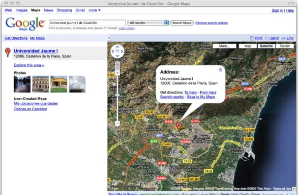
Google Maps is a map service executed on the web browser. Depending on the user's location, this can show different information such as basic or customized maps, local business information or driving directions. By default this location also determines the default view for the user. Google Maps offers several types of views including traditional map, satellite imagery, terrain model, street-level imagery and traffic view, what it is identical to the traditional map view but adding information about traffic in a given area where this information is available.
controls are showed over the map as it appears on Figure 1. This web interface offers a left panel where information like the search results is displayed. Figure 1 shows some results for a simply query where these results are listed in the left hand side panel. Usually when clicking on a marker used to indicate a location an info window or balloon appears. This info window could display additional information about that location in text but also using images, links or even videos. Depending on the user's location, Google Maps allows searching businesses, addresses, roads and intersections, places, coordinates, geographic features, real state listings, driving directions and the most interesting of all of them, user created content. This user created content includes KML-based content. The users can restrict their searches based on any of these categories. One important service offered in Google Maps is the content creation service also called My Maps. Depending again on the user's location, they can create customized maps. However these maps are restricted to the use of Placemarks, Lines and Shapes. Once the customized map is finished, the users can share it, collaborate with other users or directly open it in Google Earth. The users can also import KML or GeoRSS [30] to their map. The GeoRSS is a set of standards to represent geographic data and it is built inside the RSS [31] family that are commonly used to publish frequently updated works like news or blog entries. Applying this, the GeoRSS could be used inside Google Geo Services to represent geographic content that is frequently updated (i.e. traffic conditions). The easiest way to share the map with other users is using the specific URL that any map owns. However there exist also the option to make the map public or unlisted. A public map is included in the search results on Google Maps and Google Earth. However the unlisted maps are more restricted being only accessible for a specified group of users. The collaboration option allows other users to edit the map. It is also possible to export that map into KML format for visualizing it directly in Google Earth or other earth viewers able to work with this format.
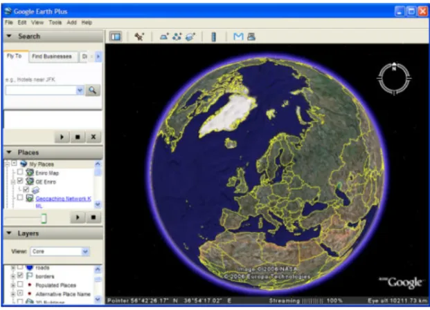
Google Earth is the Google's virtual globe, map and geographic information desktop application. Google Earth displays satellite imagery of varying resolution of the Earth's surface allowing its visualization from different angles and perspectives as it shows Figure 2. It also allows to visualize all kind of images overlaid on the Earth's surface and can work as a Web Map Service client. The use of Google Earth is based on the use of KML and KMZ files using its visualization possibilities. The KMZ files can be defined as compressed (zipped) KML files. Basically they store internally a
KML file, usually called doc.kml, and the other resources used by the KML features
(images, photos, etc) described within this file. The KML and KMZ files allow three-dimensional visualization of data like buildings or terrain and also animations on time. The users can also search for addresses, locations and other user-created content. These searches provide the same results as the searches performed using Google Maps however in this case the application has no limitation to represent KML data that contain three-dimensional information. Finally one important point is the addition of different layers that can be loaded in Google Earth. These layers include information from a broad range of sources. For instance the user can find layers displaying Wikipedia (http://wikipedia.org) information, weather forecast, content from the Google Earth gallery and much more.
Figure 2: Google Earth allows the visualization of three-dimensional Earth surface.
exist some limitations like the number of uses per day, this API provides the same set of utilities that can be found on the Google Maps website. These utilities also include the search over user-created content.
2.3. Content Publication
One of the main motivations for analyzing the use of a search engine like Google for retrieving geographic content is the simplicity of the content's publication process. The basic idea of this process is to make publicly available the users’ content and wait for Google to discover, index and rank that content. Unfortunately behind this simple idea there are much more parameters and aspects that finally determine if that content will ever be found in the search results.
Basically the Google tasks could be divided into three: Crawling, Indexing and Serving. The crawling is the process by which the Google's bot also known as Googlebot discovers new content to be added to the Google index and updates the old one. This process is supported by the huge technological infrastructure owned by Google and by the Googlebot programming. This programming determines parameters like which sites to crawl, how often or how many pages to crawl from each site. In this crawling process all the URLs in a site are analyzed and used to define new sites to crawl, changes to existing ones or dead links that finally update the Google index. The next task is the indexing, based on the compilation of an index with the words extracted from the sites analyzed by Googlebot and their location on the site. Actually Google supports the indexing of different data types, including KML files that express geographic information, but not other interesting formats such as ESRI's shapefiles [32]. In the case of the HTML pages not only the text is extracted to build up the index but also different tags and attributes. The last task is the process by which Google tries to serve as result the information it considers more relevant with the searching parameters. This process of sorting or ranking is based in a huge number of factors. One of the most famous of these parameters is the PageRank, which measures the importance of a given site based on the incoming links from other sites.
and analysis in some cases. Another reason why some content does not appear on the Google's search results could be simply because the content is not “Google-friendly”. This term is usually applied to those websites that do not follow the Google's Webmaster Guidelines [33]. These guidelines are sets of recommendations about design and content, technical and quality aspects to help Google find, index and rank the websites. The guidelines about design and content give some recommendations about the use of links and descriptive content. The technical part explains the importance of creating well formed websites, some web server functions and the use of robot.txt files to avoid the incorrect crawling of the website. The robot.txt files are simply lists of directories that the crawler must or must not visit. These files help to restrict which content will become part of Google index in those cases where all the content resides in public directories. Maybe the most important of these recommendations are the ones related with the quality. In these guidelines some of the illicit practices that can make a site become penalized or deleted from the Google index are explained. These two actions mean, in most of the cases, the removal of the site from the Google search results. The guidelines about design, content or technical aspects could influence in the indexing process of some pages or the time taken to crawl the site. However the quality guidelines are extremely important since by them it can be decided if the user's content is completely deleted from any search results provided by Google. The quality guidelines are divided into basic and specific principles. In the basic principles the user can find recommendations about the importance of designing the sites for people instead of search engines, the avoidance of the participation in link schemes to increase the number of incoming links or the error of using applications that violate the Google's Terms of Service. In the other side the specific guidelines describe more precisely aspects to avoid when releasing a website. These include the avoidance of hidden text or links, cloaking or sneaky redirects, the sending of automated queries to Google, the loading of pages with irrelevant keywords and also the avoidance of duplicate content sites creation. If any site is catalogued as if it would not accomplish the guidelines it is also possible to ask Google for reconsideration after a previous modification in order to accomplish them.
The above tries to explain briefly the general case to process all kind of supported files and include them into the Google Search Index or simply Google index. However apparently this Google Search Index is not the only one. Since the release of the different Geo services offered through Google Maps and Google Earth, Google is using a new index also known as Google Geoindex. From a simplistic point of view, the Google Search Index is queried based on keywords introduced by text. It seems that when querying for geographic content using either Google Maps or Google Earth the results obtained corresponds to the terms introduced as text but also the geographic region visualized when performing the query. In other words, it seems like the bounding box that represents the region in the viewer acts as a filter for the query results. Apparently the new Geoindex can be queried not just by words but also by region. At the same time all that geographic content is catalogued depending on its possible use and source. As previously explained, in the main Google Maps website, the users can currently filter the search by Locations, Businesses, Real State
properties, Mapped web pages and User-created content. All categories are
Figure 3 a diagram created by Barry Hunter [34] shows all the current ways to publish and retrieve geographic content using Google Geo Services.
Figure 3: Barry Hunter's diagram representing all the possible options to make available geographic content using Google's services and tools.
also differentiate, using rectangles in light orange, the different interfaces, either websites or applications that are part of the process. These interfaces are the Google Maps website, the Google Earth and Google Earth Community websites, the Google Earth desktop application, the set of different websites that actually georeference some of their content using Google's geo services and finally the own user's website where the content is published. In the diagram the box representing the User-Created Content Searches appears in both Google Maps website and Google Earth application. These boxes representing the searching are fed in both cases by the Google Geoindex without using in any case the Google Search Index.
The different content sources are represented in light green. In the first place, there are the KML files allocated in any server in the Internet. Secondly it is represented the
option of creating personalized maps using Google Maps' My Maps service. And
finally it is also represented the direct submission of geographic content through the Google Earth Community Website.
Considering the case of those KML files published in a server with public access, these files have several options to appear in Google’s Geoindex. The options can be divided into two main groups. First those options requiring some kind of action done by the content publisher. Second the actions based on an automatic processing done by the Google’s crawlers. The first group of options basically consist on submitting the KML files to Google maps or Google Earth galleries [35]. In the case of Google Earth gallery the user just need to specify a set of URLs for the KML or KMZ file and for its screenshots via a form in the gallery website. In the case of Google Maps gallery the content published is not composed by KML files but by mapplets. The mapplets could be defined as tiny applications executed inside Google maps. These are build in a similar way than the gadgets used by Google in some of their places like iGoogle, a customized Google website. There exists a complete and freely available API for these mapplets creation. Once the KML files are included in any of these galleries users can visualize the content using any of these applications. The content that compose the Google Maps gallery is automatically included in the Google Earth gallery and then becomes accessible using any of these tools. These galleries are
accessible using My Maps service on Google Maps, in different layers like Gallery in
Google Earth or simply opening the different content directly from the Google Earth gallery website.
Concerning these galleries another important aspect is the role played by the different websites that georeference part of their content using Google Geo Services. As shown in Figure 3 some of these are photo and video galleries, wikis and others. All these sites seem to share some common point, the content used is created by users, following the web 2.0 tendency. Here we have another way how users can publish geographic content on the web, however this time, without the direct use of KML or KMZ files but publishing georeferenced photos, videos or articles. Internally these websites expose all these content to Google Maps and Google Earth for its indexing probably creating KML files automatically. In the first case it is easy to find these content just performing a search or adding it through the My Maps service as mapplets. Using this service users are not limited to add and visualize content of these websites but also other content published by other users. In the case of Google Earth the users can visualize these websites content using the appropriate layers like the
Finally it is possible the automatic processing of the publicly available geographic content via the standard crawling. This is, by this study's point of view, the most interesting of the whole set of options since it seems the simplest way to be followed by any kind of user. Like Figure 3 shows there are two ways to get a KML file crawled but both are supposed to finish with the same result, the KML file included in the Google Search Index. The first way is as simple as waiting for Googlebot to index the file. This option seems to be quite passive however the second one represents a more active behavior for the publisher.. In this case the content publisher can make
use of Sitemap files [36] and Google's Webmaster Tools
(http://www.google.com/webmasters/tools). The purpose now is to help Googlebot to find the content to index and then speeding up the overall process. Both, the sitemap files and the Google Webmaster Tools, are deeper explained following. Once the content becomes indexed in the Google Search Index means that this is already suitable to appear in the search results using the Google Web Search. However this content will not appear in queries made using Google Maps or Google Earth yet. To appear in there the content needs to be part of the Google Geoindex. It is supposed that, after some delay, the geographic content is also indexed and becomes part of the Geoindex and then suitable to be found using the different products. It is important to consider the time taken for the whole process, since the content is published till it appears in the Geoindex. Even helping Googlebot, the time spend can be measured in weeks. This can seem a really long time, however as we will see in the following sections this time could be decreasing, probably because the improvement of the system's resources. Again, the user can face the problems previously described concerning the possibilities that the crawling or indexing process fails.
submitting all of them could mean a tedious and long process hard to achieve in acceptable times.
These are, at the time of writing, the different possibilities to make geographic content in KML files public and accessible using the different services for searching offered by Google. The number of options has grown since the origin of the different Google Geo Services and it is probable that the company will improve them and add new ways to facilitate the process.
Google offers to the users a set of resources to improve the discovery and indexing of their content and get at the same time information about the process status. These resources include a set of communication channels like a blog, a forum, an assistance centre and a set of different tools to help users to get their content indexed. These tools include an informative assistant to get quick information about the indexing of a given site, a set of methods to send content to the different Google services, including Google Books and Google Video, and the Google Webmaster Tools. This last one is the most interesting and useful since it offers a complete set of tools to get statistics, diagnostics and also to allow a little administration capability over the crawling and indexing process. The Google Webmaster Tools can be used to follow the process done by Googlebot, analyze the possible problems that can be found on it and fix them in order to increase the possibilities of a given site to become indexed. These tools also offer information about incoming or outgoing links in the website and the different queries that could drive traffic to it.
All the functions present in the Google Webmaster Tools are divided into the following sections:
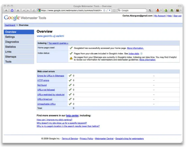
Overview: As shown in Figure 4, in this section the users can find basic information
about the indexing process status and the errors found during the crawling process. All this information is linked with other sections that extend this one offering more specific information about each specific issue.
Configuration:It allows the setting of some parameters like the geographic position,
preferred domain, the inclusion of the site for the Google Image Labeler service and the crawling frequency. The geographic position is useful for the analysis of the website in a given country and it can only be changed in those cases where the domain is not country specific (i.e. .com, .net, .org). The preferred domain option allows the user to specify the domain used by default in a website when it has more than one. The Google Image Labeler is a service intended to improve the indexing of images relating this ones with tags. Finally the crawling frequency option allows the user to recommend a specific frequency to Google, however this has not a great impact on Googlebot actions since it crawls the website based on the number of webpages present on it.
Diagnostics: This section gives information to the user about the web and mobile
crawling and the possible problems found in this process. In the case of the web errors these include HTTP errors, inaccessible URL, resources not found and more. The mobile crawling subsection shows information about problems found in the CHTML or WML/XHTML crawling, specific for mobile devices. Finally it also shows information about the website’s content giving with it information about the indexing process.
Statistics: It shows to the user information about the most common queries where the
website appears as a Google search result and also Googlebot, crawling and indexing statistics.
Links: As its name indicates, this section offers information about linked websites.
These include websites that link to and from the user's site. It also shows information about the sites links automatically generated by Google in some cases based on the site's content.
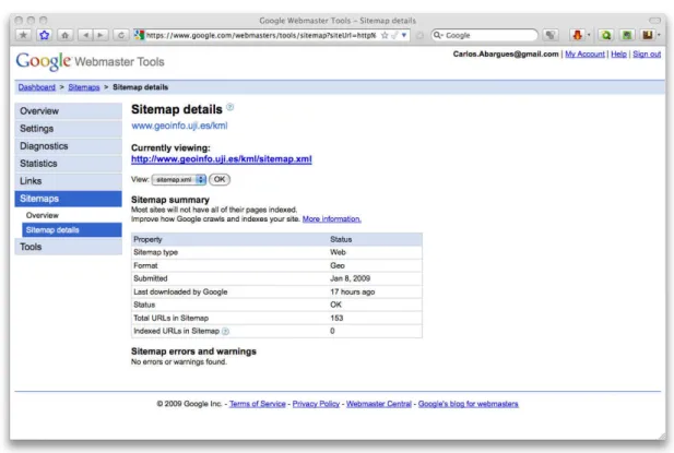
Sitemaps: This section allows the user to have some kind of control over the crawling
process thanks to the submission of sitemap files. For each sitemap sent the user can check its status, the number of URLs on it, the number of URLs indexed, the last time the file was checked by Googlebot or even the format. This format already allows the use of the special type Geo to specify geographic content. Some of these details can be found on Figure 5.
reduced number of links pointing to it and also where the content distributed in different pages is not well linked between them. Sitemap files use is not restricted to Google and are used by other search engines that adopt the standards defined by sitemaps.org.
Figure 5: Sitemap.xml file's details displayed using Google Webmaster Tools
Currently Google accepts Sitemaps described using the Sitemap Protocol 0.9. This protocol is a XML dialect to describe a site's structure information including URLs available for crawling within a website. This protocol is not limited to indicate a list of URL but it also allows the addition of more information about each URL to improve the crawling process. This information includes the domain's URL, the date of the last file's modification, the frequency of changes in the file and a priority relative to other URLs on the site. This priority can be specified using a decimal number ranging from 0.0 to 1.0. The following example shows the use of all these elements to describe an URL:
<?xml version="1.0" encoding="UTF-8"?>
<urlset xmlns="http://www.sitemaps.org/schemas/sitemap/0.9"> <url>
<loc>http://www.example.com/</loc> <lastmod>2005-01-01</lastmod> <changefreq>monthly</changefreq> <priority>0.8</priority>
</url> </urlset>
Sitemap index file. The following example shows the use of these Sitemap index files:
<?xml version="1.0" encoding="UTF-8"?>
<sitemapindex xmlns="http://www.sitemaps.org/schemas/sitemap/0.9"> <sitemap>
<loc>http://www.example.com/sitemap1.xml.gz</loc> <lastmod>2004-10-01T18:23:17+00:00</lastmod> </sitemap>
<sitemap>
<loc>http://www.example.com/sitemap2.xml.gz</loc> <lastmod>2005-01-01</lastmod>
</sitemap> </sitemapindex>
Although the Sitemaps are also used for other search engines, Google allows the use of specialized Sitemaps for concrete types of content, not supported for all the rest. Currently Google supports specialized elements for specifying video, mobile sites, news, code and geographic content. This last one represents an extension of the protocol and includes a geo-specific tag. The <geo:format> specifies the format of the geo content. These formats are limited to KML, KMZ and GeoRSS format only. Following there is an example of Geo Sitemap file:
<urlset xmlns="http://www.sitemaps.org/schemas/sitemap/0.9" xmlns:geo="http://www.google.com/geo/schemas/sitemap/1.0"> <url>
<loc>http://www.example.com/download?format=kml</loc> <geo:geo>
<geo:format>kml</geo:format> </geo:geo>
</url>
<url>
<loc>http://www.example.com/download?format=georss</loc> <geo:geo>
<geo:format>georss</geo:format> </geo:geo>
</url> </urlset>
Google recommends the use of these files since they provide additional information for the crawling process probably resulting in more pages indexed and in less time. However Google never guarantee that a URL will be added to the Google index even if this appears in a submitted Sitemap file.
Tools: In the last section of the Google Webmaster Tools panel the user can find a set
case it does not exist. These files are not required but are still useful to keep some folders invisible for Googlebot.
One important aspect about the Google Webmaster Tool is the restrictions imposed based on the use of root domains. In that case where the user is the owner of a domain like www.example.com, this user can access all the information provided by the set of statistics, tools and others. However in the case of a URL that corresponds to a directory under that root level, for instance www.example.com/subdirectory, some of the options are not available. For example this is the case of the information concerning the content analysis, crawling and Googlebot statistics among others.
2.4. Keyhole Markup Language
2.4.1. Past, Present and Future
The KML is a language designed to express geographic annotation and visualization and it is based on the XML standard. The geographic visualization includes not only the representation of the graphical data but also establishes orders or control on the navigation. KML is used for geographic content visualization in a broad range of interfaces such as web-base and two-dimensional maps (including those in mobile devices) and three-dimensional Earth browsers. Usually these applications also use KMZ.
KML was originally created by Keyhole Inc. This company was founded in 2001 and was specialized in software development for geospatial data visualization. Its main application suite was called Earth Viewer that was transformed into Google Earth in 2005 thanks to the acquisition of Keyhole Inc. by Google in 2004.
Currently a broad range of applications dedicated to visualize geographic data is using KML format. In this group of applications we can find tools such as ESRI's ArcGIS Explorer [38], OpenLayers [39], NASA's World Wind [40] or Google Earth and Google Maps among many others. KML is also used for other services that are not directly related with geographic data visualization. In this category we can find popular services like Yahoo's Flickr, a photo and video hosting and sharing service. This service allows to view geotagged photos and videos in Earth browsers such as Google Earth or even in two-dimensional viewers like Google Maps thanks to the use of KML files. This one is a clear example of how KML can be used to interconnect different services.
Another example of the increasing use of KML is the new output option in one of the
most used servers in the geographic information field, GeoServer
(http://www.geoserver.org). This supports both KML and KMZ output for WMS requests. This allows the end user to visualize the output of a WMS request to a GeoServer installation directly in an Earth browser thanks to the interface for KML files output offered.
some of them online, to create, process and import or export KML code. Two of the most useful tools are related with the translation of KML to other formats and the other way around. KML2SHP allows users to transform KML files into some of the most used formats in the GIS field, the ESRI's shapefiles, AutoCAD (DXF) [41] and GPS (GPX) [42] files . SHP2KML allows the inverse process of translating from ESRI's shapefile to KML. These tools do not support yet all the features for these formats and need to take care about some aspects related with the data's reference system for instance. However both tools are free and continuously improved. These are just some examples but the simplicity and structure of KML allows also the transformation from other more common file formats used also by non-professional users. One example could be the transformation of a Comma Separated Value (CSV) [43] file with some kind of geographic information or coordinates to KML. The CSV express a really simple structure where values are separated by commas. This format is really common for exporting information from a broad range of databases and spreadsheet applications.
These are just a few clear examples of the possibilities and projection of this file format. However the most important fact that assures its continuity and improvement is its recent recognition as an OGC standard.
On April 14th 2008 the Open Geospatial Consortium adopted KML version 2.2. as an
OGC standard what means the first step in the attempt for its harmonization with other relevant OGC standards that compose the OGC standards baseline. The most related existing OGC standards, also complementary with the new KML standard are the Geography Markup Language (GML) [44], Web Feature Service (WFS) and Web Map Service (WMS). In fact, there are some common points between GML and KML, using this last one, some geometry elements such as point or line string derived from GML version 2.1.2. This current harmonization between the two standards is planed to be increased arriving even to use exactly the same geometry representation in a future. The interoperability of KML with standard services such as WMS could be found in actual tools such as Google Earth. Using it the users can visualize and link WMS with KML files. The OGC have four major objectives regarding KML:
• That there be one international standard language for expressing geographic annotation and visualization on existing or future web-based online and mobile maps (two dimensions) and earth browsers (three dimensions).
• That KML be aligned with international best practices and standards, thereby enabling greater uptake and interoperability of earth browser implementations.
• That the OGC and Google will work collaboratively to ensure that KML community is kept informed of progress and issues.
• That the OGC process will be used to ensure proper life-cycle management of the KML Standard, including such issues as backwards compatibility.
and services is a good indicator however its standardization as an OGC standard is what seems to guarantee its continuity and improvement.
2.4.2. Structure and Elements
The KML is based on the XML standard [45]. As any other XML-based language, KML is composed by different tags or elements with a name and attributes that at the same time can contain others creating nested structures. XML files are structured and easy to process by automated agents and at the same time easy to read by people. Probably this is one of the best characteristics of XML and it is also present in all its derived languages like KML or GML.
KML is currently in its version 2.2 and its schema is publicly available under the Open Geospatial Consortium schema repository as any of their standards (http://schemas.opengis.net/kml/2.2.0). This is not only useful for learning about the structure of the language but also to validate this type of files when using some editors. In the OGC repository the KML schema is accompanied by another one, the
atom_author_link schema. This represents a subset of the Atom Syndication Format and Publishing Protocol that is designed to support publishing and syndication of text content and media resources. This subset is used in the KML schema to represent some information about the file’s author.
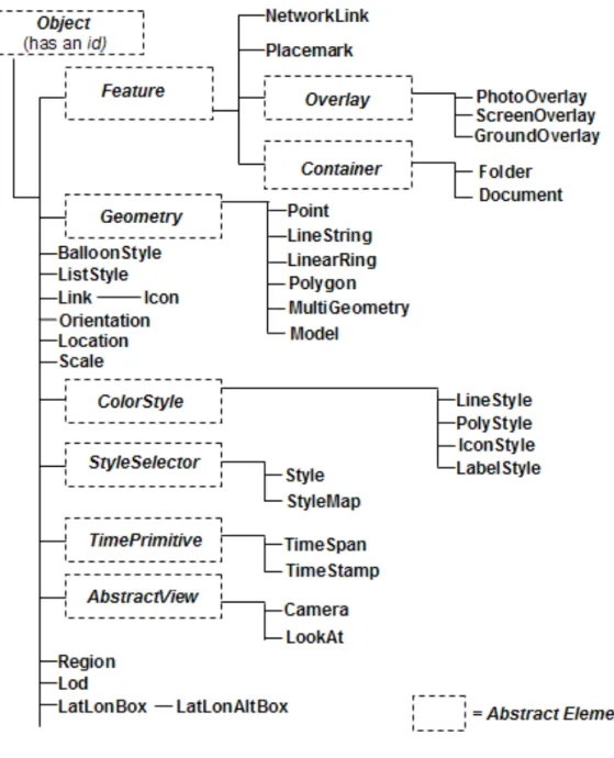
Figure 6: KML elements hierarchy
Below the <Object> level abstract and non-abstract elements are found and a subdivision based on the purpose of each element could be done. The two main usages of KML seem geographic content annotation and visualization. For instance
we have elements such as <Placemark> to annotate geographic content and
<LookAt> or <Camera> that define some characteristics about the visualization of this content in three-dimensional earth browsers. This categorization based on the purpose gives also a first reference about the elements suitable to store and transport descriptive information or metadata about the content. Reviewing the KML specification seems that all those elements used to specify visualization parameters like <ColorStyle>, <StyleSelector>, <TimePrimitive> or <AbstractView> and all its derived elements do not offer any way to carry information that could be used in searches, unless the user would need to search features on time where the
strictly related with the specification of characteristics for content visualization are not explored in this study.
In the following tables (Table 1, Table 2, Table 3, Table 4, Table 5, Table 6 and Table 7) the principal or most interesting KML elements for annotating geographic information that were used to store descriptive information in the experiment performed are presented. However some other elements, although they can be used to annotate geographic content and carry descriptive information are not described.
Some of these are for instance the Overlay-derived elements. Along with their name
and description some of the most important derived or specific elements and attributes are also explained.
Feature (inherits from Object)
Description Abstract element that sets some general structure for its inherited elements.
name
Specifies the Feature’s name. It is used as the object’s label in the three-dimensional viewers.
visibility
Specifies if the Feature is open in the viewer when it is loaded.
open
Similar to visibility but specifying if it appears open in the list of features (i.e. Places panel in Google Earth). It is only applicable to Container-derived elements (Folder and Document).
atom:author
Element extracted from the Atom Syndication Format specification (http://atompub.org) used to specify the content’s author.
atom:name
Specific element of atom:author used to indicate the author’s name.
atom:link
Through its attribute href it specifies the URL to the website containing the KML or KMZ file.
description
Describes the Feature. It can contain plain text and a subset of HTML formatting elements such as tables, images or even videos. It is also possible to insert links to other elements configuring some options. Among these elements the user can specify scripts that return KML or KMZ files.
snippet Major elements
address
Represents an unstructured address. Its use is restricted based on the functionality given by Google in the country where the Feature is situated.
xal:AddressDetails
Represents a structured address, formatted using the international standard for address formatting extensible Address Language (http://www.oasis-open.org/committees/ciq/ciq.html#6). It can be used for geocoding in Google Maps.
Table 1: KML Feature element details.
NetworkLink (inherits from Feature)
Description References a KML or KMZ file on a local or remote network.
refreshVisibility
Indicates if the visibility of the Feature referenced should be reset automatically in the earth browser every time the link is refreshed.
flyToView
Indicates if the viewer should move the virtual camera as specified by other KML elements specifically designed for visualization purposes.
Link Major elements
Specifies the location of remote resources (KML or KMZ files). It has specific elements to set the URL and other parameters related for example with the refreshment rate. With this element it is also possible to visualize WMS services output in earth browsers allowing the specification of some WMS specific parameters like BBOX (Bounding Box).
Table 2: KML NetworkLink element details.
Placemark (inherits from Feature)
Description Describes a Feature with an associate geometry.
Geometry Major elements
Specifies the geometry used by the Placemark. This can be any of the Geometry-derived elements.
Container (inherits from Feature)
Description Abstract class that is used as base for other derived elements that hold one or more Features allowing the creation of nested hierarchies.
Table 4: KML Container element details.
Folder (inherits from Container)
Description Contains other features and allows their arrangement creating hierarchical structures.
Table 5: KML Folder element details.
Document (inherits from Container)
Description Contains other features allowing their hierarchical arrangement and the organization of the different KML elements. It is required when using shared styles between different elements. It is also required to define the Schema element that allows the definition of custom XML schemas within a file.
Table 6: KML Document element details.
Geometry (inherits from Object)
Description Abstract element used as basis for all the elements defining
geometry in KML: Point, LineString, LinearRing, Polygon,
LinearRing, MultiGeometry and Model.
Table 7: KML Geometry element details.
KML is a really complete standard and define much more elements. Probably one of the most interesting elements in the KML specification is the <ExtendedData>
element. This new element in version 2.2 allows the user to add custom XML data to any Feature-derived element. This can be done using three techniques:
1. Adding data/value pairs using the <Data> element.
2. Defining custom KML schemas with the <Schema> element and using them in any <Feature> via the <SchemaData> element.
3. Using XML elements or schemas defined in other namespaces (i.e. other files)
by referencing the external namespace within the KML file.
The addition of data/value pairs is the simplest of the three techniques. This pairs are expressed in KML using the element <Data>. This element allows the creation of this kind of pairs but does not allow specifying any type for them. Its basic structure is the following:
<Placemark>
<name>Club house</name> <ExtendedData>
<Data name="holeNumber"> <value>1</value> </Data>
</ExtendedData> </Placemark>
Basically the <Data> element specifies the pair name using an attribute name and the value using its child element <value>. It is also possible to specify the pair's name using the element <displayName>. This allows the user to create a formatted version
of the name that includes the use of HTML tags. Usually <displayName> is used for
visualization purposes on earth browsers since this value is displayed within the <Feature> element'sinfo window when this is available.
The second technique requires the use of the elements <Schema> and
<SchemaData>. The <Schema> element is used to define custom KML schemas that can be used to add custom data to KML <Features> elements by the element <SchemaData> element. These <Schema> elements use to be declared as child elements of <Document> and have two attributes, name and id. This last one must be unique and it is used to reference the <Schema>. Inside the element the user can declare different custom fields using the <SimpleField> element. This element allows the specification of the field's type and name as attributes. Again the <displayName>
element can be used for the same purpose. Attributes type and name must be specified
or the custom field will be ignored. The types the user can specify are some of the most common ones: string, int, uint, short, ushort, float, double and bool. The next code shows an example:
<Schema name="string" id="ID">
<SimpleField type="string" name="string"> <displayName>...</displayName> </SimpleField>
</Schema>
The <Schema> elements declared are used to add custom data to a <Feature> using the element <SchemaData>. From an object-oriented point of view, the <Schema>
element could be understood as the object declaration, being the <SchemaData>
element the instance of that object. The <SchemaData> element refers to a specific <Schema> using its attribute schemaUrl. This attribute can contain a string representing a full URL for referencing other files or a <Schema> id defined also in other or in the same KML file. An example of its use can be found following:
<SchemaData schemaUrl="http://host.com/zclv.kml#my-schema-id"> <SchemaData schemaUrl="zclv.kml#my-schema-id">
![Figure 3 a diagram created by Barry Hunter [34] shows all the current ways to publish and retrieve geographic content using Google Geo Services](https://thumb-eu.123doks.com/thumbv2/123dok_br/15757186.639055/22.892.146.752.171.948/figure-diagram-created-hunter-current-retrieve-geographic-services.webp)