Precolumbian land us
and settlement pattern in
and use
rn in
arém region,
azon
Precolumbian land use
and settlement pattern in
the santarém region,
lower amazon
University of Gotehenburg, Sweden
P E R S T E N B O R G
Universidade Federal do Pará, Brasil
D E N I S E P A H L S C H A A N
Laboratório de Arqueologia Curt Nimuendajú, Brasil
PRECOLUMBIAN LAND USE AND SETTLEMENT PATTERN IN THE SANTARÉM REGION, LOWER AMAZON
Abstract
One of the most promising areas for the study of pre-Columbian complex societies in the Amazon River basin is the area of the lower Tapajos, Trom-betas and Nhamundá rivers. There are written accounts on the Konduri and Tapajó Indians, presenting information on their regional social organization, trade patterns, abundance of foods, and material world. Hence, archaeologi-cal evidences – immense sites, full of anthrosols remains, and beautiful ar-tefacts – may be contrasted with written information. These rich cultural deposits are vanishing at an alarming rate, as urban centres grow, and agricul-ture expands in the region. Despite this situation, little archaeological research has been conducted in the area, especially when it comes to investigations of ancient settlement systems and trade patterns. In the last couple of years, we have performed surveys in the Lower Tapajós River basin. The archaeologi-cal record indicates that pottery showing strong stylistic resemblance to that found at the large central site is spread at least as far as 90km to the south of present Santarém city. This article presents the results of a regional survey in the vicinities of Santarém, in the Belterra plateau, and Alter do Chão, offering a preliminary settlement system analysis in the region.
Keywords: Tapajó ceramics, settlement patterns, lower Amazon.
USO DA TERRA E PADRÃO DE ASSENTAMENTO PRÉ-COLOMBIANO NA REGIÃO DE SANTARÉM, BAIXO AMAZONAS
Resumo
e Alter do Chão, oferecendo uma análise preliminar do sistema de as-sentamentos na região.
Palavras-Chave: Cerâmica tapajônica, padrões de assentamento, baixo Amazonas.
USO DE LA TIERRA E PATRONES DE ASENTAMIENTO PRE-COLOMBINOS EN LA REGIÓN DE SANTARÉM, BAJO AMAZONAS
Resumen
Una de las áreas más prometedoras para el estudio de las sociedades complejas precolombinas en la cuenca del río Amazonas es el área del curso inferior de los ríos Tapajós, Trombetas y Nhamundá. Hay relatos escritos sobre los Konduri y los Tapajó, presentando información sobre sus patrones de organización social, de comercio regional, la abundancia de alimentos, y el mundo material. Por lo tanto, la evidencia arqueológica – muchos sitios, los suelos antropogénicos y ricos artefactos – se puede contrastar con la información escrita. Estos depósitos culturales están desapareciendo a un ritmo alarmante, en la medida en que los centros urbanos están creciendo y la agricultura se expande en la región. A pesar de esto, poca investigación arqueológica se ha realizado en la zona, sobre todo cuando se trata de investigar los patrones de asentamiento antiguos y los intercambios regionales. En los últimos años hemos llevado a cabo investigaciones en la cuenca del bajo río Tapajós. El registro arqueológi-co indica que cerámicas arqueológi-con fuerte similitud estilística arqueológi-con la que se en-cuentra en el grande sitio central se extiende por al menos 90 kilómetros al sur de la ciudad de Santarém. Este artículo presenta los resultados de una investigación regional realizada en las inmediaciones de Santarém, la meseta de Belterra y en Alter do Chão, ofreciendo un análisis preliminar del sistema de asentamientos en la región.
INTRODUCTION
The earliest ethnohistorical sources (particularly Carvajal 1934) described densely populated provinces of con-siderable sizes situated along the Ama-zon River floodplain and bluffs, which would have a regional political organiza-tion, riverine-hinterland trade systems, and productive subsistence systems. Mid-20th century archaeology, however,
downplayed the accounts of Carvajal and others (Schávelzon and Zarankin 1992). This standpoint particularly attached im-portance to the ecological assessments of the Amazon basin resources, which, it was reasoned, would imply limitations for the development of dense, complex polities, given the assumed poor soils and limited protein sources (Beckerman 1979, Meggers 1954, Steward 1948). This carrying capacity way of looking at the interactions between human beings and environment was early on criticized by scholars from different fields (Carneiro 1960, Denevan 1966, Lathrap 1970, Myers 1973), whom argued both that the Amazon environment were being taken as uniform, without consideration for the varied and different niche which existed, and that human societies could overcome environmental constraints, with creative responses in order to maximize food production, even increasing soil fertil-ity through mulching, frequent burning, and the building of raised/ridged fields. Indeed, Amazonian studies, beginning in the 1980s, started to yield compelling evidence that human societies had in fact transformed their surroundings in dif-ferent ways, and that Amazonian forests were not pristine environments to which
humans were obliged to adapt. Quite to the contrary, according to this view, human agency was considered a prime mover in producing part of the current biodiversity (Balée 1989, Posey and Balée 1989, Smith 1980).
Evidence for the existence of complex, regional societies in the region on the eve of European contact were soon presented also by archaeologists, be-ginning with the pioneer work of Anna Roosevelt in Venezuela (Roosevelt 1980), where she identified a growth in demog-raphy and social complexity associated with the adoption of maize cultivation. Although Roosevelt’s work was tied to a strong deterministic view towards the environment, she emphasized, in op-position to Meggers, the bountiful re-sources of the basin, and the fertility of the floodplain (Roosevelt 1989, 1991). Following an increase in quantity and quality of information, the debate has since expanded from discussions about the existence of chiefdoms in the Ama-zon basin, to include topics such as the likelihood that a variety of social forma-tions emerged during the last two millen-nia, changing landscapes of floodplains and hinterland in diverse ways – a his-tory that was cut short by the European invasion (Erickson 1980, 2006, Gomes 2007, Heckenberger and Neves 2009, Heckenberger 2005, Heckenberger et al. 2003, Neves 1999, Schaan 2001, 2008, 2012). This also points to the importance of improving our understanding of the changes which the European involve-ment brought about.
settle-ments during the late pre-Columbian times which has attracted considerable attention lately (notably including that of the medias), is that of the Ama-zonian Dark Earths – ADE (or terra preta soils), commonly found associated with archaeological artifacts (Kern and Kampf 1989, Lehmann 2003, Smith 1980, Sombroek 1966, Woods et al. 2009, Woods and McCann 1999). These are anthropogenic soils, formed through the deposition of organic ma-terial at least to some extent an unin-tentional side-effect of diverse human activities, including food preparation, decayed wood and palm houses, craft-work, burial remains, and so forth (Kern 1988, Kern and Kampf 1989). The possibility that terra preta was pro-duced intentionally as a strategy of soil improvement has been stressed by several researchers (e.g. Hecht 2003, Steiner et al. 2008, Woods and Mc-Cann 1999). Suggested procedures for soil enhancement include particular methods of clearing, usually referred to as “slash-and-char”, in which py-rolysis (a burning method with limited supply of oxygen) is the dominating type of burning and addition of vari-ous kinds of organic waste (Steiner, Teixeira, and Zech 2004). The degree of intentionality behind the human-driven formation of the ADE and re-lated environmental modifications has yet to be evaluated.
Terra preta was formed on top of latos-sols, often accompanied by cultural layers that in some places can reach more than 2m of deposits and a plen-titude of cultural material and artifacts.
The terra preta formation processes still have to be systematically defined and isolated from the more ordinary ac-cumulation of cultural material and formation of cultural layers associ-ated with human activity. Terra preta
researchers have stressed the large distribution of these soils throughout the basin, and the fact that they are testimonies of large societies occupy-ing the Amazon river bluffs and also the hinterlands (terra firme) (Kern et al. 2004). Such soils have high pH, high organic content, high concentrations of P, Ca, Mg, Mn, besides being incred-ibly resistant to leaching. Given their persistence through time, they are sup-posed to provide clues for settlement chronology and demographic density (Glaser and Woods 2004, Lehmann et al. 2003, Schaan, Kern, and Frazão 2009, Woods et al. 2009). Stability is therefore a distinguishing mark of the
terras pretas. Hence, although the settle-ments that once somehow produced them in most cases vanished in the 16th and 17th centuries, the soils have
and Heckenberger 2001), agricultural productivity (Madari, Sonbroek, and Woods 2004) and in demonstrating that the Amazonian landscape is to a considerable extent anthropogenic (Denevan 2001, Lehmann et al. 2003, Oliver 2001, Woods et al. 2009). As previously noted, recent research indicate that the Amazon basin housed a variety of social formations in pre-Columbian times. However, there is a great need to improve our understand-ing of how these societies were related to one another. Concerning the chrono-logical conditions our knowledge is still fragmentary and in great need of reinforcement. Regarding contempo-raneously existing societies their socio-political interrelationship need close examination. Having these aims in prospect, an important step is to build up in-depth information of settle-ment history through time. In order to analyse the origins of socio-economic variation, it must be put in relation to a variety of factors, amongst other those involved in the formation of group-identities, subsistence patterns, mobility, as well as positions in pre-Columbian systems of exchange and trade.
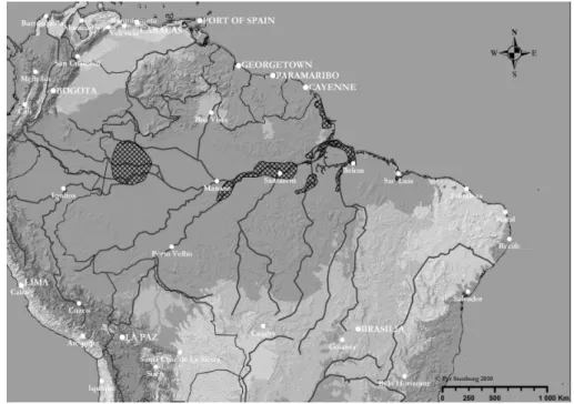
In this article, we focus on the study of settlement systems related to the societies that developed by the mouth of the Tapajós River from the latter half of the first millennium A.D. on-wards (Figure 1). The Tapajó were met by Europeans in the 17th century, but
their culture and social organization probably vanished rapidly after their defeat against the Portuguese in 1639. Nimuendajú (Nimuendajú 2004:188)
assumed that the population declined rapidly during the 16th and 17th
centu-ries as a result of slavery, warfare and oppression from the colonial power. The survivors were in most cases re-located to the historical villages and missions in the areas of today’s San-tarém, Alter do Chão, and Vila Franca do Lago Grande, together with native populations of other background (Ca-balzar 2003). Although some informa-tion on their social organizainforma-tion, sub-sistence patterns, and symbolic world is available from the historical sources, we depend on archaeological research in order to reconstruct their ancient way of life, their geographical disper-sion, their relation to other polities, and the history of their emergence and development through time. While archaeological research has been con-ducted at the central site in Santarém, a site lying underneath the present city of Santarem, the available results are still preliminary (Quinn 2004, Roos-evelt 1999, Schaan 2010), and no ar-chaeological attempts have been made to explore and analyse the organiza-tion of these pre-Columbian societies at a regional level.
Given the lack of information on Tapajó regional organization and geo-graphical importance, our initial work has focused on studying sites located in the Belterra Plateau, many of them earlier located by the German-Brazil-ian researcher Nimuendajú in the first half of the 20th century, during his
1949, 2004). In this paper we present the results from our fieldwork accom-plished so far, proposing a preliminary settlement pattern analysis which sets the foundation for the ongoing research in the area, aiming at contributing to a general debate on the development and history of complex societies in the Amazon basin.
THE SANTARÉM REGION
The later prehistory of the Santarém region in the lower Amazon (considering the Tapajós and the Trombetas/Nha-mundá river basins) is characterized by the emergence of two related but distinct ceramic complexes: Santarém (mainly distributed south of the Ama-zon River) and Kondurí (found to the north of the Amazon River). There are a few C14 and TL dates associated with Santarém and Kondurí pottery (Gomes 2001, 2005, Guapindaia 2008, Hilbert and Hilbert 1979, Pouguet 2002, Quinn 2004), but both complex-es have been preliminarily dated to the
period AD 1000-1700.
A key issue for the future is to analyze the formation and distribution of terra preta in the Santarém region in relation to sustenance and settlement systems and socio-economic organization. As noted above, in reconstructing the factors involved in the formation of terra preta, it is of critical importance to establish the relation between this process and the formation, or accu-mulation, of organic and inorganic material in cultural layers. Hence, any occurrences of terra preta unaccompa-nied by the typical content of cultural layers, such as pottery and osteological remains, as well as the contrary case of accumulated cultural material in non-terra preta strata, are of significant interest. Pre-vious research on terra preta particularly concerned with the Santarém region in-cludes the work of Woods and McCann (1999, Woods 1995).
Trade routes and networks for com-munication may directly and indirectly have linked enormous areas together. These routes of communication along
waterways would have involved key points, particularly in the junctions between north-south and east-west connections. A tentative theory is that interruptions of the reasonably ho-mogenous pattern of material culture found along the Amazon, exemplified by the dominance for Santarém and Kondurí ceramics in the investigation area may reveal the positions of par-ticularly important routes of commu-nication along the tributaries. In this scheme, the Santarém Region would form a key area for investigation.
CURT NIMUENDAJÚ
The German-Brazilian researcher Curt Unkel Nimuendajú is mostly known for his ethnographic fieldwork car-ried out among lowland Amerindian populations in the first half of the 20th century. His work has formed an
important source of information for later research (Clastres 1975, Lévi-Strauss 1955, Lévi-Lévi-Strauss 1985, Vi-veiros de Castro 1986). Until quite re-cently only limited information about Nimuendajú’s archaeological research in the Brazilian Amazon had been published (Linné 1928, Linné and Montell 1925, Meggers and Evans 1957, Nimuendajú 1949, Nordenskiöld 1930, Palmatary 1939, 1960, Wassén 1934). More recently, however, the posthu-mous publication of his detailed field reports (Nimuendajú 2004), as well as correspondence (Nimuendajú 2000) has helped showing the importance also of his archaeological and histori-cal studies (see also Stenborg 2009). Much of his archaeological fieldwork
was carried out on behalf of the Go-thenburg Museum in Sweden, which was by the time becoming a centre for Amerindian Studies under the direc-tion of Erland Nordenskiöld.
Nimuendajú’s archaeological fieldwork covered a vast region, from the upper Rio Negro, Rio Uaupés and Rio Içana in the north-western Amazon all the way to the regions of Belém, Marajó, Mexiana and Caviana as well as Amapá by the Atlantic shore (Figure 2). His in-vestigations thus dealt with many key areas concerning Amazonian pre-Co-lumbian history and yielded a unique material from numerous archaeologi-cal sites (Figure 3). The Santarém re-gion was, however, the object of study for his most ambitious investigation – a fact also reflected by the large num-ber of items from this region included in the collections that he sent to the museum in Gothenburg.
NIMUENDAJÚ’S RESEARCH IN THE AREAS OF SANTARÉM, LOWER TAPAJÓS AND LAGO GRANDE DE VILA FRANCA
The material sent to the Gothenburg Museum mainly consists of decorated pottery and fragments in the shape of zoomorphic appendages and figurines. Although these are common features of the Santarém pottery, Nimuendajú undoubtedly selected this kind of mate-rial, putting away fragments of plain ceramics as well as material that he
regarded to date from the time of Eu-ropean contact (Nimuendajú 2004:151). Lithic materials included hoes, stone spindle whorls, Muiraquitãs (frog shaped green stone pendants) and stone-idols. During the next few years he under-took further investigations in the San-tarém, Tapajós and Lago Grande areas, also exploring sites in neighbouring
re-Figura 2 – The hatched areas give a rough estimation of the areas where Curt Nimuendajú carried out archaeological investigations for the Gothenburg Museum between 1922 and 1927.
gions. He described the Santarém ma-terial as a characteristic ceramic com-plex easily distinguished from materials found in adjacent areas. Another distinct ceramic complex was that of the Kon-durí pottery, replacing the Santarém pottery north of the Amazon River; in the region of Rio Nhamundá and Rio Trombetas. South of the Amazon River he found the limit between the San-tarém material and that of the Kon-durí some 140 km west of Santarém city, at Serra Bananal. To the south-west the Santarém material bordered on that of the Maué, while he ascribed divergent materials to the west to the Tupinambarana and the Aroagui. To the East he found Santarém-like mate-rial as far as Água Boa by Rio Curuá, while a markedly different material was found further east, by the Igarapé Cuçary and Lago da Boa Vista, as well as by Monte Alegre, on the northern side of the Amazon River. He was not able to certify how far the Santarém material extended to the south, but found it as far as Aramanaí, situated some 90 km south of Santarém, on the right bank of Rio Tapajós. He estimated that a material, which he held to be that of the Sapupé, replaced the San-tarém complex somewhere between lat. 3° and 4°S.
SOCIO-ECONOMIC DEVELOPMENT AND POLITICAL ORGANIZATION
It is reasonable to assume that Nimuendajú collected materials originated from several different time-periods. It is there-fore unlikely that all the “areas” identified by Nimuendajú represent the remains
of material culture from contemporane-ously existing societies. As stated in the foregoing, available dates for the San-tarém and Kondurí pottery associate both complexes with the late first and early second millennium A.D. This is why we may suggest that these materials were produced by societies that existed – at least partly – contemporaneously (see below). Both complexes further belong to the Incised-and-Punctate tradition (Meggers and Evans 1961). The co-occurrence of a number of traits within a spatially delimited area indicates (at the least) that people interacted differently within this region, than between this and neighbouring regions. To the extent that a homogenization of material culture also implied the spreading of properties such as modes of production, land use, socio-political organization and the like it also renders a development towards po-litical unity quite likely.
THE HISTORICAL RECORD AND MATERIAL DATA
1541-42. Such a development may account for some of the dissimilari-ties found as we compare Orellana’s chronicler, Gaspar de Carvajal’s ac-count, with later sources (Bettendorf 1990, Porro 1994). During the course of the establishment of trade relations with the Europeans, the riverbeds may once again have been occupied by na-tive villages. The constitution of such post-contact societies settled in the vicinity of the Amazon River may of course have been quite different from their predecessors.
Needless to mention, the historic in-formation constitutes an invaluable source of information concerning historic and late prehistoric times. However, as argued elsewhere (e.g. Schaan 2004, Stenborg 1998), it is es-sential for archaeology to establish an independent empirical fundament for its generation of hypotheses. Initially, therefore, the aim will be to improve our knowledge about the material re-cord in this region.
AVAILABLE DATA CONCERNING TEMPORAL ASSOCIATIONS OF THE ARCHAEOLOGICAL MATERIAL
The existing dates from the Santarém and Trombetas–Nhamundá areas in-dicate that the Santarém and Kondurí complexes belong to a late phase of Amazonian pre-Columbian history. The results of luminescence dates for samples from the Santarém material at Museu de Arqueologia e Etnologia at the University of São Paulo under-taken by Gomes (2001) centred on
the period A.D. 900 to 1200. Quinn (2004:147) published a series of 16 radiocarbon dates of material from the Santarém Porto-site. The calibrated results of 14 of these have ranges spanning from the 13th to the early 17th
materials may constitute a gap or inter-ruption in the distribution of the Ama-zonian Polychrome ceramics during late pre-Columbian times. These interrup-tions coarsely coincide with the areas of confluence between the Amazon and the Trombetas and Nhamundá rivers to the north and the Tapajós River to the south, why the impact that communication and mobility along these tributaries may have had on the development should be con-sidered.
Altough scholars such as Roosevelt (1992) point to an abrupt change from the Polychrome Horizon to the Incised-and-Punctate, evidence from Andirobal and Port sites indicate that the appearance of Incised-and-Punctate ceramics in the area did not replace the polychrome pottery. Con-versely, potters related to the Incised-and-Punctate Horizon copied from the painted pottery some geometric designs, and both horizons co-existed simultaneously in the ceramics pro-duced with distinct functions.
THE FIELDWORK CARRIED OUT IN 2008
A field campaign undertaken in 2008 consisted in surveying and mapping a large number of archaeological sites over an area covering the regions from the city of Santarém at 54°43' W and 2°26'S and approximately 100km to the east on the southern side of the branch of the Amazon River to lon-gitude 54°05'W and southward about 40km to latitude 2°40'S south of the city of Alter do Chão (cp. Nimuendajú 2004:131, 153f) at the right bank of
the Tapajós River. This fieldwork was facilitated by grants from the Rausing Foundation, the University of Gothen-burg and the University of Pará, and was carried out as a form of rescue work, in the view of a rapid increase in the destruc-tion of the archaeological record of this key region for the understanding of the lowland South American history. The record is being destroyed for a number of reasons, such as mining activities, road and pipe-line construction, and (as men-tioned above) in particular for agricul-tural purposes.
A total of 43 archaeological sites were mapped using a Trimble GeoXH GPS (for a list of sites, see the appendix) (Figure 4). Real-time differential cor-rection was not available on site, but could be applied during post processing of the GPS data in Sweden using data from the SOPAC, Kourou, base-pro-vider situated some 895km from the area of investigation. The quality of the collected data could thereby be im-proved from an average precision of about 20m to about 1m.
In addition to the fieldwork in No-vember 2008, the Brazilian research-ers have surveyed further areas in the projected region of investigation. In 2006, Denise Schaan and Marcio Amaral surveyed areas to the south of Santarém not covered by the 2008 sur-vey (Schaan 2006). More recently, they have continued the non intrusive field surveys, expanding the area of inves-tigation further east by including the Monte Alegre area (cp. Nimuendajú 2004:140–143, 147–150) on the north-ern side of the Amazon River, as well as further to the west by covering vast region surrounding the Lago Grande de Vila Franca (Ibid. :134f, 155).
PRELIMINARY RESULTS
The total number of archaeologi-cal sites recorded and mapped during these surveys amount to approximate-ly 80. It is estimated that the collec-tions at the Museum of World Culture in Gothenburg include material from about 50% of these sites. The total number of items collected by Nimuenda-jú for the museum in Gothenburg is 8,234 and approximately half of these have come from sites situated within the projected geographical area of in-vestigation.
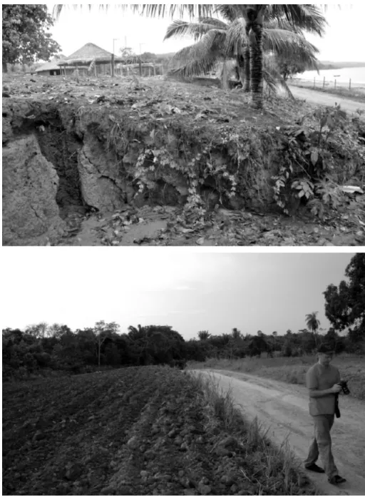
The great majority of the surveyed sites are remains of settlements situ-ated at typical terra preta soils, particu-larly fertile anthrosols, rich in organic matter and contrasting sharply with
the otherwise poor soils found in the Amazon region (Figure 7). The sizes ranges from 0.1ha (Guari) up to 16ha (Santarém-Aldeia) and the depth of the terra preta strata varies from 0.2m (Pindobal 1) to 2m (Vila Americana and Santarém-Aldeia) (Figure 8). To date the time of initial formation of the terra preta layers, and to associate this environmental change with trans-formations in human action and pos-sibly with the emergence of new so-cioeconomic structures, institutions and modes of production, may be considered primary tasks.
However, in order to investigate the origin and significance of terra preta, it is also important to examine anomalies concerning the co-occurrence between
terra preta and cultural material such as pottery and bone. In case terra preta
was produced deliberately in order to improve potentials for food produc-tion, it may be postulated that areas used exclusively or primarily for ag-ricultural activities would show com-parably low concentrations of such cultural material. Furthermore, it may be suggested that this would mean that settlement areas used for non-agricul-tural purposes (e.g. as dwellings) would demonstrate a weaker association with environmental modifications, such as deliberate soil improvement, as com-pared to agricultural areas, while the deposition of refuse such as frag-ments of pottery and bone would be of substantial influence. If, on the other hand, terra preta originated as an unintentional consequence of pre-Columbian human activities, it might be suggested that, through time, the pattern of land-use followed an
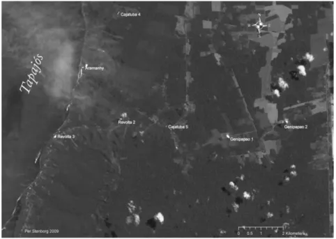
Figure 7 – Sites mapped near the eastern shore of Rio Tapajós; the conjunction between prehistoric settlement remains and areas selected for modern agriculture is clearly discernable. By Per Stenborg 2009.
all chronology where domestic space subsequently was re-utilized and trans-formed into agricultural areas. In this latter case, while quite possibly linked to the emergence of certain patterns of human action, the formation of
terra preta would have been unrelated to the subsequent use of terra preta for agricultural ends.
Another fundamental question con-cerns the lapse of time between com-mencing actions leading up to the transformation of non-terra preta soils into terra preta, and the appearance of soil improvement at a scale of sig-nificance for agricultural production. The shorter the time needed in order to obtain significant improvement in fertility, the greater the probability that these actions were intentionally under-taken in order to increase agricultural productivity.
In the regional approach adopted in this study the spatial distribution of various resources is an additional key issue. The preconditions for obtain-ing and producobtain-ing comestibles vary between different parts of the San-tarém region. In addition to exploita-tion of terra preta areas, flood recession agriculture may have been practiced in seasonally inundated floodplains (Winklerprins 2002). The amount of sediment carried by the rivers is an important aspect concerning the po-tentials for flood recession agriculture. Whitewater rivers, rich in suspended material, such as the Amazon River, offer superior conditions for this kind of agriculture, in comparison with clear-and black-water rivers such as
the Tapajós. Assuming that seasonally flooded areas along the Amazon were used for agriculture, the need for soil improvement would have been lesser than along the Tapajós and in the in-land. Survey will therefore include dif-ferent ecozones and analyze the dis-tribution of terra preta with respect to differences concerning environmental preconditions. Future work therefore will include documentation of the size, thickness and cultural content of
terra preta patches in different sectors of the region to allow reconstruction of prehistoric management of terres-trial resources and socio-economic de-velopment. This work will make use of GIS-technology for spatial modeling, analysis, geovisualization and spatio-temporal analysis (e.g. Longley et al. 2005, Mehrer and Wescott 2006). Preliminary results of these initial in-vestigations reveal the existence of various types of sites in the area of investigation (Figures 8 and 9). Tenta-tively three types of settlements have been distinguished:
large population centers.
2) A second type of sites are of similar size, but contain much lower concen-trations of cultural material, thinner
terra preta strata (in many cases of lighter color, referred to as Terra Mulata, after Sombroek 1966) and, although situ-ated near water resources, their distri-bution is not limited to the proximities of the main waterways. These sites include Juá, Jacú, Pindobal, Lavras II, Lavras III, Carapanari I, Carapanari IV and Carapanari V. A working hypothe-sis is that these sites were primarily tied to agriculture. An alternative interpre-tation is that their period of occupa-tion was considerably shorter than that
of the first category of settlements. In some cases, such as that of Alter do Chão, historical sources give evidence of the existence of settlements in post-contact times (in that case the “Aldeia Borary”, cf. Nimuendajú 2004:131). 3) The third category are made up of smaller sites, displaying terra preta de-posits of varying depths, with limited access to surface water. The concen-tration of archaeological material is relatively high. Genipapo I, Genipapo II, Bom Futuro and Posto Novo be-long to this category. In all probability this category covers sites of different ages, having had a variety of functions during their occupation. Tentatively,
this “morphological” category may be presumed to include:
3a. Installations associated with specialized resource management. At Genipapo the existence of an artificial well reported by Nim-uendajú (2004: Plate 203) was verified. The outer perimeter of this well, measuring some 15 to 20m in diameter, was mapped. The construction of these wells must have required considerable investment of labor and a sig-nificant degree of organization. Presence of excavated wells could therefore be an indication of incorporation into a socio-political organization at a level of structuring beyond that of individual villages and installations.
3b. Settlements predating the emergence of large population centers and the development of socio-political organization beyond that of the individual village or village groups. At ear-lier stages population numbers may have been comparably low, with considerably less integra-tion into regional political and economic systems, reducing the importance of juxtaposition to the main waterways.
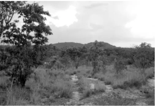
3c. Site postdating the initial moments of European contact (i.e. the mid 16th century
on-ward). In post-contact settings, processes of change, involving dramatic reduction of popula-tion numbers, as well as strate-gic and preventive relocations
of settlements to remote and sheltered positions, sometimes on hill tops (Figure 10), have been demonstrated for other Latin American regions (Sten-borg 2002).
The results of the surveys so far ac-complished indicate that neither terra preta, nor archaeological sites in general, are more abundant in the vicinity of the Amazon River, than along the lower Tapajós and in the inland areas. Rather, there appear to be concentrations of sites in the southwestern part of the surveyed area, near the village of Bel-terra (Tapajós), as well as in some inland areas, such as that of Lavras 1-3 and Jacú. At present rate of destruction a large number of these site will have van-ished within a few years (the logging and destruction of forest land in the Santarém region is easily discernible on satellite images, for example at
Google Earth), a circumstance increasing the need of further documenting and investigating these archaeological re-mains as soon as possible.
Future work will attempt to date the period of initial terra preta formation in this region. Based on that knowledge it will be possible to investigate the rate of association between sites from the “terra preta”– period and the terra pre-tas themselves. Were these sites, as a rule, associated terra preta soil forming, or were there contemporary sites where activities neither depended on terra preta soils, nor did result in terra preta
formation?
In this manner we will be able to identify
different settlement types as well as set-tlement systems. A number of type-sites will be investigated with respect to terra preta formation, association between par-ticular cultural remains and initial period of terra preta formation.
Of fundamental interest is the pre-historic management of terrestrial resources, in particular the terra preta
anthrosols, through combined archae-ological and soil science analyses. The formation and use of the terra preta
soils can only be understood by track-ing a variety of interacttrack-ing processes at several scales, including soil pro-cesses, environmental control, modes of production, subsistence strategies at various levels and socio-political organization. This demands a broad multidisciplinary research effort (cf. Madari et al. 2004). By tracing particu-lar activities we also aim at identifying functionally specialized installations other than those tied to agriculture. We hereby aim at producing a model concerning systems of production and modes of interaction at different scales in the region of study.
REFERENCES
Balée, W. 1989. The culture of Amazonian forests, in Resource management in Amazonia: in-digenous and folk strategies. Advances in Economic Botany vol. 7. Edited by D. A. Posey and W. Balée, pp. 1-21. New York: New York Bo-tanical Garden.
Beckerman, S. 1979. The abundance of pro-tein in Amazonia: A reply to Gross. American Anthropologist 81:533-60.
da Companhia de Jesus no Estado do Maranhão. Lendo o Pará 5. Belém: Fundação Cultural do Pará Tancredo Neves, Secretaria de Es-tado da Cultura.
Cabalzar, A. 2003. Kumurõ. Banco Tukano. São Paulo: Instituto Socioambiental.
Carneiro, R. L. 1960. Slash-and-Burn agricul-ture: A closer look at its implications for set-tlement patterns, in Men and Cultures. Edited by A. F. C. Wallace, pp. 229-34. Philadelphia: University of Pennsylvania Press.
Carvajal, G. d. 1934. Discovery of the Orella-na River, in The discovery of the Amazon according to the account of friar Gaspar de Carvajal and other documents. Edited by J. T. Medina, pp. 167-235. New York: American Geographical Society. Clastres, H. 1975. La terre sans mal: Le prophé-tisme Tupí-Guarani. Paris: Éditions du Seuil. Denevan, W. M. 1966. The aboriginal cultural geography of the Llanos de Mojos. Berkeley: Uni-versity of California Publications.
____. 2001. Cultivated landscapes of Native Amazo-nia and the Andes: triumph over the soil. Oxford Geo-graphical and Environmental Studies. Oxford, UK New York: Oxford University Press.
Erickson, C. L. 1980. Sistemas agrícolas prehis-panicos en los Llanos de Mojos. América Indígena 40:731-755.
____. 2006. “he domesticated landscapes of the Bolivian Amazon, in Time and Complexity in Historical Ecology. Edited by W. Balée and C. Erickson. New York: Columbia.
Glaser, B., and W. I. Woods. 2004. Amazonian dark earths: explorations in space and time. Berlin/ New York: Springer.
Gomes, D. M. 2001. Santarém: symbolism and power in the tropical forest, in Unknown amazon: Culture in nature in ancient Brazil. Edited by C. McEwan, C. Barreto, and E. Neves, pp. 134-55. London: British Museum Press. ____. 2005. Análise dos padrões de organização
comunitária no baixo Tapajós: o desenvolvimento do for-mativo na área de Santarém, PA. Doctoral Disser-tation, University of São Paulo, São Paulo, Brazil.
____. 2007. The diversity of social forms in pre-colonial Amazonia. Revista de Arqueologia Americana 25:189-226.
Guapindaia, V. L. C. 2009. Além da margem do rio - a ocupação Konduri e Pocó na região de Porto Trombetas, PA. Doctoral Dissertation, Univer-sity of São Paulo, São Paulo, Brazil.
Hecht, S. B. 2003. Indigenous soil manage-ment and the creation of Amzonian Dark Earths: Implications of Kayapó practices, in
Amazonian Dark Earths. Origin, properties, man-agement. Edited by J. Lehmann, D. C. Kern, B. Glaser, and W. I. Woods, pp. 355–372. Dor-drecht, Boston, London: Kluwer Academic. Heckenberger, M., and E. G. Neves. 2009. Amazonian archaeology. Annual Review of Anthropology 38:251-266.
Heckenberger, M. J. 2005. The ecology of power: Culture, place, and personhood in the Southern Ama-zon, A.D. 1000-2000. Nova York & Londres: Routledge.
Heckenberger, M. J., A. Kuikuro, U. T. Kui-kuro, J. C. Russel, M. Schmidt, C. Fausto, and B. Franchetto. 2003. Amazonia 1492: Pristine Forest or Cultural Parkland? Science
301:1710-1713.
Heckenberger, M. J., J. B. Petersen, and E. G. Neves. 1999. Village size and perma-nence in Amazonia: Two archaeological examples from Brazil. Latin American An-tiquity 10:353-376.
Hilbert, P. P. 1968. Archäologische Undersuchun-gen am Mitteren Amazonas. Beiträge zor Vorge-schichte des Südamerikanischen Tieflandes. Mar-burger Studien zur Völkerkunde. Berlin: Dietrich Reimer Verlag in Berlin.
Unterer Amazonas. Beiträge zur Allgemeinen und Vergleichenden Archäologie Band 1:439-450. Kern, D., G. d'Aquino, T. E. Rodrigues, F. J. Frazão, W. Sombroek, T. Myers, and E. Neves. 2004. Distribution of Amazonian Dark Earths in the Brazilian Amazon, in
Amazonian dark earths: explorations in space and time. Edited by B. Glaser and W. Woods, pp. 51-75. Berlim: Springer-Verlag.
Kern, D. C. 1988. Caracterização pedológica de solos com Terra Preta Arqueológica na Região de Oriximiná, Pará. Master’s Thesis, Universidade Federal do Rio Grande do Sul, Brazil. Kern, D. C., and N. Kampf. 1989. Antigos as-sentamentos indígenas na formação de solos com Terra Preta Arqueológica na Região de Oriximiná, Pará. Revista Brasileira de Ciência do Solo 13:219-25.
Lathrap, D. W. 1970. The Upper Amazon. New York: Praeger.
Lehmann, J. 2003. Amazonian dark earths: origin properties management. Dordrecht, Boston: Klu-wer Academic Publishers.
Lehmann, J., D. Kern, B. Glaser, and W. Woods. 2003. Amazonian dark earths: origins, propoerties, management. Netherlands: Kluwer Academic Publishers.
Lévi-Strauss, C. 1955. Tristes Tropiques. Paris: Librairie Plon.
____.1985. La potière jalouse. Paris: Librairie Plon. Linné, S. 1928. Les recherches archéologiques de Nimuendajú au Brésil. Journal de la Société des Americanistes de Paris (nouvelle série) XX:71–91. Linné, S., and G. Montell. 1925. Från Brasiliens In-dianer i Forntid och Nutid. C. Nimuendajús arkeologis-ka och etnografisarkeologis-ka forskning. Göteborg: Göteborgs Museum, Etnografiska Avdelningen.
Longley, P. A., M. Goodchild, D. J. Maguire, and D. W. Rhind. 2005. Geographic Information Systems and Science. Chichester: John Wiley & Sons.
Madari, B. E., W. G. Sonbroek, and W. I. Woods. 2004. Research on anthropogenic Dark Earth Soils. Could it be a solution for a sustainable agricultural development in the Amazon?, in
Amazonian Dark Earths: Explorations in space and time. Edited by B. B. Glaser and W. I. Woods, pp. 169-181. Berlin: Springer.
Meggers, B. J. 1954. Environmental limitation on the development of culture. American An-thropologist 56:801-24.
____. 1992. Tropical forest environments and archaeology: a view from Amazonia, in
Environment and archaeology. Edited by A. G. Pantel, K. A. Schneider, and G. Loyola-Black. San Juan, Puerto Rico.
Meggers, B. J., and C. Evans. 1957. Archeologi-cal investigations at the mouth of the Amazon. Vol. Bulletin 167. Washington, D.C., Smithsonian Institution Bureau of American Ethnology U.S. Govt. Print. Off.
____. 1961. An experimental formulation of Horizon styles in the tropical forest area of South America, in Essays in Pre-Columbian art and archaeology. Edited by S. K. Lothrop, pp. 372-288. Cambridge: Harvard University Press.
Mehrer, M. W., and K. L. Wescott. 2006. GIS and archaeological site location modelling. London: CRC. Myers, T. P. 1973. Toward a reconstruction of prehistoric community patterns in the Amazon basin, in Variation in anthropology: Es-says in honor of John C. McGregor. Edited by D. Lathrap and J. Douglas, pp. 233-252. Urbana: Illinois Archaeological Survey.
Neves, E. G. 1998. Paths in dark waters: archaeol-ogy as indigenous history in the upper rio Negro basin, northwest Amazon. Ph.D. Dissertation, Indiana University.
Museu Paraense Emílio Goeldi. Série Antropolo-gia 10:93-108.
____. 2000. Cartas do Sertäo de Curt Nimuendajú para Carlos Estevão de Oliveira. Lisboa: Museu Nacional de Etnologia, Assíro and Alvim. ____. 2004. In Pursuit of a Past Amazon. Ar-chaeological researches in the Brazilian Guyana and in the Amazon region. Gotenborg: Elanders In-fologistik.
Nordenskiöld, E. 1930. L'Archaeologie du Basin de L'Amazone. Paris: G. van Oest.
Oliver, J. R. 2001. The archaeology of forest foraging and agricultural production in Ama-zonia, in Unknown Amazon: Culture in nature in ancient Brazil. Edited by C. McEwan, C. Bar-reto, and E. Neves, pp. 50-85. London: The British Museum Press.
Palmatary, H. C. 1939. Tapajó Pottery. Vol. 8.
Etnologiska Studier. Göteborg: Göteborgs Et-nografiska Museum.
—. 1960. The archaeology of the lower Tapa-jós Valley, Brazil. Transactions of the American Philosophical Society 50.
Petersen, J. B., M. J. Heckenberger, and E. G. Neves. 2001. Prehistoric ceramic sequence in the centrral Amazon and its relationship to the Caribbean. XIX International Congress for Caribbean Achaeology, Aruba, 2001, pp. 250 - 259.
Petersen, J. B., E. G. Neves, and M. J. Hecken-berger. 2001. Gift from the past: Terra Preta and prehistoric Amerindian occupation in Amazonia, in The unknown Amazon. Culture in nature in ancient Brazil. Edited by C. McEwan, C. Barreto, and E. G. Neves, pp. 86-105. Lon-don: British Museum Press.
Porro, A. 1994. Social organization and politi-cal power in the Amazon floodplain: the eth-nohistorical sources, in Amazonian indians from prehistory to the present: Anthropological perspectives.
Edited by A. C. Roosevelt, pp. 79-94. Tucson: University of Arizona Press.
Posey, D. A., and W. Balée. Editors. 1989. Resource management in Amazonia: In-digenous and folk strategies. Advances in Economic Botany vol.7. New York: New York Botanical Garden.
Pouguet, M. 2002. Chronologie de la Période Céramique de l’Achéologie Amazonienne: Réflexions Théoriques et Méthodologiques,
Pontifícia Universidade Católica do Rio Grande do Sul.
Quinn, E. R. 2004. Excavating “Tapajó” ce-ramics at Santarém: Their age and archaeo-logical context. M.A. Thesis, Department of Anthropology, University of Illinois at Chi-cago, USA.
Roosevelt, A. C. 1980. Parmana: Prehistoric maize and manioc subsistence along the Amazon and Orinoco. New York: Academic Press.
____. 1989. Resource management in Ama-zonia before the conquest: Beyond ethno-graphic projection, in Resource Management in Amazonia: indigenous and folk strategies, vol. 7, Advances in Economic Botany. Edited by D. A. Posey and W. Balée, pp. 30-62. New York: The New York Botanical Garden.
____. 1991. Moundbuilders of the Amazon: geo-physical archaeology on Marajo Island, Brazil. San Diego: Academic Press.
____. 1992. Arqueologia Amazônica, in
História dos Índios no Brasil. Edited by M. C. da Cunha, pp. 53-86. São Paulo: Fapesp, Cia das Letras, SMC.
____. 1999. The development of prehistoric complex societies: Amazonia: a tropical for-est, in Complex polities in the ancient tropical world.
Edited by E. A. Bacus and L. J. Lecero, pp. 13-33.
Schaan, D. P. 2001. Into the labyrinths of Marajoara pottery: status and cultural iden-tity in an Amazonian complex society, in The Unknown Amazon. Nature in culture in ancient Brazil. Edited by C. McEwan, C. Barreto, and E. G. Neves, pp. 108-133. London: British Museum Press.
____. 2004. The Camutins chiefdom: Rise and development of complex societies on Marajó Is-land, Brazilian Amazon. Ph.D. Dissertation, Department of Anthropology, University of Pittsburgh, USA.
____. 2006. Diagnóstico do patrimônio arqueológico na área de influência da rodovia BR-163 - Trecho Santarém-Rurópolis. Belém, UFPA, 39 pp. ____. 2008. The nonagricultural chiefdoms of Marajó Island, in Handbook of South Ameri-can Archaeology. Edited by H. Silverman and W. Isbell, pp. 339-357. New York: Springer. ____. 2010. Salvamento do Sítio PA-ST-42: Porto de Santarém. Final Report. Belém: UFPA. Un-published.
____. 2012. Sacred geographies of ancient Ama-zonia: Historical ecology of social complexity. New frontiers in historical ecology vol 3. Walnut Creek, CA: Left Coast Press, Inc.
Schaan, D. P., D. C. Kern, and F. Frazão. 2009. An assessment of the cultural practices be-hind the formation (or not) of anthropogenic black earth in Marajo Island archaeological sites, in Amazonian Dark Earths: Wim Som-broek's vision. Edited by W. Woods, W. teixeira, J. Lehmann, C. Steiner, A. WinklerPrins, and L. Rebellato, pp. 127-141. Berlin: Springer. Schávelzon, D., and A. Zarankin. 1992.
Arqueología de San Telmo: excavaciones en la igle-sia y residencia jesuítica de Nuestra Señora de Belén (actual San Telmo). Buenos Aires: Universidad de Buenos Aires, Facultad de Arquitectu-ra, Diseño y Urbanismo, Instituto de Arte Americano e Investigaciones Estéticas Mario J. Buschiazzo.
Smith, N. 1980. Anthrosols and human carrying capacity in Amazonia. Annals of the American Association of Geographers 70:553-566.
Sombroek, W. G. 1966. Amazon soils. A re-connaissance of the soils of the Brazilian Amazon Region. Wageningen: Centre for Agricultural Publication and Documentation.
Steiner, C., W. G. Teixeira, and W. Zech. 2004. Slash and Char: An Alternative to Slash and Burn Practiced in the Amazon Basin, in Ama-zonian Dark Earths: Explorations in space and time. Edited by B. B. Glaser and W. I. Woods, pp. 183-194. Berlin: Springer.
Steiner, C., W.G. Teixeira, W. I. Woods, and W. Zech. 2008. Indigenous knowledge about terra preta formation, in Amazonian Dark Earths: Wim Sombroek's Vision. Edited by W. I. Woods, W. G. Teixeira, J. Lehmann, C. Steiner, A. WinklerPrins, and L. Rebellato, pp. 193-204. Netherlands: Springer Dordrecht. Stenborg, P. 1998. The troublesome xenogamy between archaeology and ethnohistory: Examples from research on north-western Argentinian prehistory and early history, in
Past and present in Andean prehistory and early history, vol. 42, Etnologiska Studies. Edited by S. Ahlgren, A. Muñoz, S. Sjödin, and P. Sten-borg, pp. 75-90. GöteSten-borg, Gothenburg: Et-nografiska Museeti.
____.2002. Holding back history: Issues of resis-tance and transformation in a post-contact setting, tucumán, Argentina c. A.D. 1536–1660. Vol. 21.
GOTARC, series B, Archaeological Theses. Göte-borg: Göteborg University.
____. 2009. Points of Convergence - Routes of Divergence: Some considerations based on Curt Nimuendajú’s archaeological work in the Santarém-Trombetas area and at Amapá, in Anthropologies of Guayana: Cultural Spaces in Northeastern Amazonia. Edited by N. L. White-head and S. W. Alemán, pp. 55-73. Tucson: The University of Arizona Press.
in Handbook of South American Indians, vol. 3. Edited by J. Steward. Washington D.C.: Smithsonian Institution. Bureau of American Ethnology. Bulletin 143.
Teixeira, W. G., D. C. Kern, B. E. Madari, E. N. Lima, and W. Woods. Editors. 2009. As ter-ras pretas de índio da Amazônia. Sua caracterização e uso desse conhecimento na criação de nvoas áreas.
Manaus: Embrapa Amazônia Ocidental. Viveiros de Castro, E. 1986. Araweté: Os deuses canibais. Rio: Jorge Zahar.
Wassén, S. H. 1934. The frog-motive among the South American Indians. An-thropos 29:319-37.
Winklerprins, A. M. G. A. 2002. Seasonal floodplain-upland migration along the lower Amazon River. Geographical Review 92:415. Woods, W. I., and J. M. McCann. 1999. The Anthropogenic Origin and Persistence of Amazonian Dark Earths. Yearbook, Conference of Latin Americanist Geographers 25:7-14. Woods, W. I., J. Lehmann, L. Rebellato, C. Steiner, W. G. Teixeira, and A. M. G. A. WinklerPrins. 2009. Amazonian Dark Earths: Wim Sombroek’s Vision. Dordrecht: Springer Netherlands.
APPENDIX: LIST OF SITES SURVEYED AND MAPPED WITH GPS IN NOVEMBER 2008
A. SITES MAPPED IN THE REGION SOUTH OF SANTARÉM. (7-8/11, 2008)
1.Mararú: An area of terra preta, considerably damaged by modern, small-scale agricultural activities. One modern house has been constructed on the remains of the site. No cultural material visible on the surface.
2. Mararú 2: Site extending over approximately 20ha. Ceramic fragments are found in abundance on the surface of the ground. The area is used for mecha-nized agriculture and Papaya-cultivation.
3. Cuiarana: Heavily damaged terra preta site. Most of the black soil has been cul-tivated away, and today only small areas of terra preta soil remain
4.Lavras 1: Very large terra preta area, partly damaged by modern agriculture. Large quantities of pottery, predominately of Santarém type are visible on the surface of the ground.
5. Boa Fé: terra preta area.
6. Comunidade terra preta: terra preta area.
7. Jacú: Area used for modern cultivation. The limit between the terra preta and surrounding, poorer soils is easily seen as a distinct change in colour.
8. Lavras 2. terra preta site, most of which is presently used as cultivation camps. 9. Lavras 3: terra preta site similar to TP2 to which it may in prehistoric times have been an extension.
10. Fim de Lavras: Situated on a high/slope. Distinct border between terra preta
and terra mulata soils,
11. Santa Maria: Polychrome pottery of the Incised-Punctuated tradition found on the surface
B. SITES SITUATED IN THE REGION NEAR THE WESTERN SHORE OF THE TAPAJOS RIVER. (8/11-2008)
12. Vila Americana 13. Cacoalinho
16. Maracanã (Situated close to the city of Santarém) C. SITES NEAR ALTER DO CHÄO (9/11-2008)
17. Pindobal, sandy terra preta soil, by the Tapajós River 18. Sítio Cedro Rei. Distinct pottery (non-Tapajoid) 19. Serra do Mocotó
20. Capiranga
D. SITES IN THE ENVIRONS OF SANTARÉM CITY. (10/11-2008)
21. Santarém Aldeia
22. Sitio Porto– Vera Paz (rims of funerary vessels were here visible in the hard-packed surface of the ground)
E. SITES IN THE REGION EAST OF SANTARÉM. (11/11-2008)
23. Guaraná1 24. Serra Grande 25. Santana do Ituqui 26. Pacoval
27. Água boa–Paraíso
F. THE REGION SOUTH OF ALTER-DO-CHÃO. (12/11-2008)
28 Porto Novo – Small terra preta on hilltop by the road
29. Cajatuba 1: Large terra preta area, now heavily damaged by modern construc-tion. The central portion of the terra preta covering various km. Indications of agriculture, such as a stone hoe
30. Cajatuba 4
31. Revolta 1: Similar to Lavras. Extensive terra preta areas, only interrupted by minor spots of poorer soil
32. Revolta 2: Large area of dark terra preta, including much cultural material Ex-tending some 800m further to the south
find-ing place of the muyraquita (frog pendant) depicted below.
34. At the Tapajós forest reserve (FLONA) we had to turn back as the guard did not let us pass through.
35. Jenipapo 1: (Nimuendajú 2004:Plate 081)
36. Jenipapo 2: Small terra preta with carbon in the surface, some pottery
37. Bom Futuro The existence of an ancient artificial well had been indicated by Nimuendajú (2004). This information could be supported by the finding of an excavated well in the Bom Futuro zone. The outer perimeter of the reservoir measuring some 15 to 20m in diameter and was mapped.
G. SITES IN THE REGION WEST OF SANTARÉM (13/11-2008)
38. Sítio Juá: Large terra preta site at the shore, probably extending ca. 1 km along the shore and 200-300 m inland. May have had particular functions tied to agri-culture as well as exploitation of aquatic resources.
39. Carapanari 1 (6780-): Elongated terra preta at “hilltop”. Great concentrations of archaeological material, including tapajoid pottery.
40. Carapanari 2: Relatively extensive terra preta site. Has been damaged by road construction. The terra preta Strata is about 1,5m deep. Situated on height. 41. Carapanari 3. Similar to C2, but situated in a less pronounced high position. 42. Jatoba 1.
43. Jatoba 2. terra preta, in elevated position, but heavily damaged by road con-struction debris. Have probably extended far beyond the measured areas, indica-tions of farming, such as hoes and axes.