Technical Note
,
Use of Geographic Information
Systems in
Control Programs for Onchocerciasis
in Guatemala1
FRANK
0.RICHARDS,
JR.*
P
eriodic ivermectin (Mectizan0,3 Merck) treatment of persons with Onchocercu z~olvulus infections reduces their risk of developing blinding ocular lesions (I). The drug, given once or twice a year as a single oral dose, is safe enough to administer (with a few exceptions) to en- tire populations of affected communities. Major distribution programs are cur- rently delivering thousands of doses of ivermectin in endemic communities of Mexico, Guatemala, and Ecuador.Epidemiologists involved in onchocer- ciasis control need to classify communi- ties by their disease risk and priority for
‘This technical note will also be published in Span- ish in the Boletin de la Oficina Sanitaria Panamericana, vol. 114, no. 3, 1993. The copyright of the Pan American Health Organization does not apply to this work, which was prepared as part of the au- thor’s official duties as an employee of the United States Government.
ZMedical Officer, Division of Parasitic Diseases, Na- tional Center for Infectious Diseases, United States Centers for Disease Control, Atlanta, Georgia 30333, USA.
Wse of trade names is for identification only and does not imply endorsement by the U.S. Public Health Service or the U.S. Department of Health and Human Services.
52 Bulletin of PAHO 27(l), 1993
ivermectin treatment (2). Geographic in- formation systems (GIS), which combine data base and digital mapping functions, have an enormous potential for assisting with this task (3). Powerful and relatively inexpensive GIS software-most notably MapInfo (MapInfo Corporation), GisPlus (Caliper Corporation), AtlasGIS (Strategic Mapping), and ARC/INFO for PCs (ESRQ- is available for microcomputers (4).
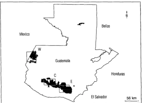
In Guatemala, transmission of oncho- cerciasis is known to occur in three cir- ’ cumscribed zones designated “western,” “central,” and “eastern” (5, 6). The black- fly vectors (primarily Simulium ochmceund in these zones breed in pristine streams that arise in the Sierra Madre and Sierra Los Cuchumatanes mountain ranges. Be- low an elevation of 500 meters, temper- atures are too hot to support high vector densities; while above 1 500 meters, cooler temperatures retard both the fly’s biting frequency and the microfilaria’s devel- opment to the infectious (L3) stage (6, 7). Therefore, concentrated transmission, high prevalence, and ocular disease oc- cur almost exclusively in communities lying between 500 and 1 500 meters (8).
onchocerciasis-endemic zones in Guate- mala. First, using large-scale (1:50 000) maps, we systematically entered the names, elevations, and latitude/longi- tude coordinates of 2 939 communities located in or near those zones. We then stratified them by elevation and pro- duced an electronic pin map of the 1 288 communities (44% of the data base) lying between 500 and 1 500 meters (Figure 1A). After that, using functions available in the program, we were able to dynami- cally “zoom in” on parts of the country map, such as the portion of the central endemic area shown in Figure 1B.
The software that we used permits identification of each community by name, by a unique ID number, by political sub- division, and by elevation. Figures in the data base files may be accessed and changed without exiting the mapping program. Overlay functions (up to 250) allow collation of other variables-such as demographic variables, epidemiologic indices (nodule rates, microfilaria rates, and microfilaria intensities), road condi- tions (all weather or seasonal), rivers and streams (shown in Figure lB), and areas served by primary health care outposts.
Systematized targeting and evaluation constitute important activities in all iver- mectin treatment programs in the hemi- sphere. The effectiveness and dispatch with which these activities are performed can be expected to play a significant role in moving toward the Pan American Health Organization’s goal of eliminating new ocular onchocercal lesions from the Americas by the year 2000 (9). Toward this goal, GIS permits rapid assessment of drug coverage, analysis of impact in- dicators, and scheduling of community retreatment in the Guatemalan ivermec- tin distribution campaign.
Within this context, certain problems should be noted that limit the immediate use of GIS by national control programs. First, good boundary files (i.e., digitized
maps) are not readily available in the en- demic countries (Brazil, Colombia, Ec- uador, GuatemaIa, Mexico, and Vene- zuela) . Commercially produced computer maps usually lack the precision needed for epidemiologic planning. Therefore, we found that the best approach was to dig- itize our own maps-a relatively labor- intensive task.
Second, many governments (including that of Guatemala) restrict large-scale maps for security reasons. Large-scale maps or gazetteers are used to identify the coor- dinates of small villages, where the most severe onchocerciasis occurs (8). In the absence of these, relatively inexpensive
(US$ 1 500) hand-held instruments are available that can establish village coor- dinates using the satellite global posi- tioning system.
Third, successful GIS application re- quires an epidemiologist who has time, above-average computer literacy, and en- thusiasm for the subject.
And fourth, a GIS system costs money. Software prices typically run between US$ 1 000 and US$ 3 500 (4), and their export may be limited to Europe, Can- ada, and the United States. Minimum computer hardware requirements (for IBM-compatible systems) include an 80286 CPU, a 40 megabyte hard disk, a battery backup system (“UPS’), and an EGA monitor. A digitizing pad is almost es- sential. If a high-resolution printer or a plotter is added, the total cost easily reaches US$ 6 000-7 000.
Yet despite the fact that these problems cannot be ignored, none appear insur- mountable. Indeed, it seems very likely that GIS will soon be an important tool for health professionals planning or di- recting field-based control programs of the sort described here.
Editorial note: From 1987 to 1992, Dr. Richards worked in Guatemala at the Medical EntomoIogy Research and Train-
Figure 1A. A total of 1 288 triangles are plotted on the map of Guatemala, these representing communities located between 500 and 1 500 meters elevation, most of them within or bordering the western (W), central (C), and eastern (E) zones of endemic onchocerciasis in Guatemala.
Mexico
A-
l
Belize
56 km -I
Figure 1B. This more detailed map provides zoom magnification of a portion of Figure 1A. That portion, considerably smaller than any of the rectangles in Figure 1 A, comes from a part of the central (C) zone on the slopes of the volcano Fuego. The communities targeted for potential treatment are again represented by triangles, and the thin lines show rivers and streams. These thin lines terminate near the western and eastern edges of the chart, where map digitization has not yet been completed. The crater of the volcano Fuego is shown in the upper right corner of the map.
ing Unit (MERTU), a field station oper- ated by the United States Centers for Dis- ease Control. During that time, he worked closely with numerous national institu- tions involved in the ivermectin delivery program in that country, including the Ministry of Public Health and Social Wel- fare, the Universidad de1 Valle de Gua-
temala, and the National Committee for the Blind and Deaf. Financial support for the ivermectin delivery program has been provided by several international sources,
among them the International Eye Foun- dation, the United States Agency for In-
ternational Development, and the UNDl’/ World Bank/WHO Special Program for Research and Training in Tropical Dis- eases. Other institutions collaborating in the delivery program include PAHO, the University of Arizona, Tulane Univer- sity, and the Mectizan Expert Commit- tee. The GIS project was funded by the River Blindness Foundation.
REFERENCES
1. Taylor HR, Greene BM. The status of iver- mectin in the treatment of human oncho-
cerciasis. Am ] Trop Med Hyg. 1989;41: 460-466.
2. DeSole G, Fiese J, Keita FM, et al. Detailed epidemiological mapping of three oncho- cerciasis foci in West Africa. Acfu Trap (Basel). 1991;48:203-213.
3. Hastings DA, Clark DM. GIS in Africa:
problems, challenges and opportunities for cooperation. Int ] Geogr Inf Sys. 1991;5: 29-39.
4. Kendall R. Mapping software: analyzing a world of data. PC Msg. 199l(July):249-275. 5. Yamagata Y, Suzuki T, Garcia Manzo GA.
Geographical distribution of the preva- lence of nodules of Onchocercu volv~lus in Guatemala over the last four decades. Trap Med Parasitol. 1986;37:28-34.
6. Shelly AJ. Vector aspects of the epide- miology of onchocerciasis in Latin Amer- ica. Annu Rev Entomol. 1988;30:337-366. 7. Ramirez Perez J. Human onchocerciasis foci
and vectors in the American tropics and subtropics. Bull Pan Am Health Organ. 1986; 20:381-402.
8. Tada I, Aoki Y, Rimola E, et al. Oncho- cerciasis in San Vicente Pacaya, Guate- mala. Am ] Trop Med Hyg. 1979;24:67-71. 9. Pan American Health Organization. Re-
port of the First Interamerican Conference
on Onchocerciasis &X091): April 26-May 1, 1991, Tapachula, Mexico, and Guate- mala City, Guatemala.