UNIVERSIDADE DE LISBOA
FACULDADE DE CIÊNCIAS
The impact of tropical cyclone Hayan in the Philippines:
Contribution of spatial planning to enhance adaptation in
the city of Tacloban
Doutoramento em Alterações Climáticas e Políticas de Desenvolvimento Sustentável
Especialidade em Ciências do Ambiente
Carlos Tito Santos
Tese orientada por:
Professor Doutor Filipe Duarte Santos
Professor Doutor João Ferrão
Documento especialmente elaborado para a obtenção do grau de Doutor
Faculdade de Ciências Faculdade de Letras Instituto de Ciências Sociais Instituto Superior de Agronomia
Instituto Superior Técnico
Faculdade de Ciências Sociais e Humanas Faculdade de Ciências e Tecnologia
UNIVERSIDADE DE LISBOA
FACULDADE DE CIÊNCIAS
The impact of tropical cyclone Haiyan in the Philippines:
Contribution of spatial planning to enhance adaptation in
the city of Tacloban
Doutoramento em Alterações Climáticas e Políticas de Desenvolvimento Sustentável
Especialidade em Ciências do Ambiente
Carlos Tito Santos
Júri:
Presidente:
Doutor Rui Manuel dos Santos Malhó; Professor Catedrático Faculdade de Ciências da Universidade de Lisboa
Vogais:
Doutor Carlos Daniel Borges Coelho; Professor Auxiliar Departamento de Engenharia Civil da Universidade de Aveiro Doutor Vítor Manuel Marques Campos; Investigador Auxiliar
Laboratório Nacional de Engenharia Civil(LNEC)
Doutor João Manuel Machado Ferrão; Investigador Coordenador Instituto de Ciências Sociais da Universidade de Lisboa, Orientador
Doutor João Pedro Teixeira de Abreu Costa; Professor Auxiliar com Agregação Faculdade de Arquitetura da Universidade de Lisboa
Doutor André Filipe Fernandes; Bolseiro Pós-doutoramento
Faculdade de Ciências Sociais e Humanas da Universidade Nova de Lisboa, na qualidade de especialista de reconhecido mérito Doutor Gil Pessanha Penha-Lopes; Investigador
Faculdade de Ciências da Universidade de Lisboa
Documento especialmente elaborado para a obtenção do grau de Doutor
Faculdade de Ciências Faculdade de Letras Instituto de Ciências Sociais Instituto Superior de Agronomia
Instituto Superior Técnico
Faculdade de Ciências Sociais e Humanas Faculdade de Ciências e Tecnologia
i
Resumo
Desde o primeiro relatório de avaliação do Painel Intergovernamental sobre as Alterações Climáticas, que se têm estudado e procurado determinar uma possível influência das alterações climáticas na frequência e intensidade dos ciclones tropicais. Esta ligação potencial foi difícil de comprovar inicialmente, devido ao facto de os efeitos do aquecimento global não se fazerem sentir tão acentuadamente. Posteriormente, com os crescentes impactos dos ciclones tropicais a afectarem globalmente cada vez mais as populações locais e infraestruturas, mais estudos foram efectuados para perceber se existia uma influência das alterações climáticas na actividade dos ciclones tropicais. Apesar de existirem algumas incertezas científicas sobre a forma como as alterações climáticas afectam os ciclones tropicais, a variabilidade do clima e as alterações climáticas estão definitivamente a influenciar estes fenómenos climáticos extremos que se estão a tornar mais intensos e devastadores. Este estudo analisará a discussão científica sobre a influência das alterações climáticas nos ciclones tropicais.
O Quinto Relatório de Avaliação do Painel Intergovernamental para as Alterações Climáticas de 2013 concluiu que o aquecimento do clima era inequívoco. Estudos mais recentes concluíram ainda que este facto contribuiu para que a temperatura da superfície do mar esteja a aumentar, o que faz com que mais água evapore para a atmosfera e contribua para a intensificação dos ciclones tropicais. O aquecimento global estará também a causar a subida do nível do mar, o que agravará o impacto das inundações resultantes da sobrelevação marítima dos ciclones tropicais em zonas costeiras baixas. Em 2013, foi ultrapassada pela primeira vez a média global de concentração de dióxido de carbono (CO2) na atmosfera em 400 partes por milhão, sendo que o valor máximo recomendado de concentração de CO2 é de 450 partes por milhão, de forma a limitar o aumento das temperaturas globais em 2°C. O Acordo de Paris de 2015, têm como objectivo manter o aumento da temperatura da atmosfera bastante abaixo dos 2°C e desenvolver esforços para reduzir o aumento da temperatura para
1.5°C. O ano de 2015 foi considerado como ano mais quente de que há registo, alcançando pela primeira vez 1°C acima da temperatura da era pré-industrial.
Consequentemente, o Acordo de Paris representa um apelo à acção no que diz respeito ao aumento das emissões dos gases com efeito estufa e através deste acordo a comunidade internacional iniciou medidas importantes com vista à sua redução.
Nas regiões afectadas pela passagem de ciclones tropicais, as zonas costeiras estão cada vez mais expostas à intensidade destes fenómenos extremos, influenciados por factores naturais e antropogénicos. Os impactos têm sido devastadores, não só em termos de números de vítimas bem como de prejuízos avultados, afectando cidades que frequentemente levam anos a recuperar economicamente. Estes desastres naturais afectam em especial os mais pobres, que normalmente são os que sofrem mais vítimas e danos materiais.
Comunidades, ecossistemas e infraestruturas são particularmente vulneráveis aos impactos destes fenómenos climáticos extremos, por se encontrarem em zonas sujeitas a riscos. As cidades afectadas por ciclones tropicais demoram frequentemente tempo a recuperar, por não terem podido antecipar e investir em medidas preventivas e por terem falta de planos de adaptação e de medidas resilientes ao clima, não só para as infraestruturas bem como para os diferentes sectores e serviços.
Muitas das cidades costeiras densamente povoadas, necessitam antecipar e adaptar regularmente o ordenamento do território de forma a poderem reduzir as vulnerabilidades aos ciclones tropicais. Como tal, o ordenamento do território pode desempenhar um papel fundamental através da integração das medidas de adaptação às alterações climáticas e redução do risco de catástrofes, nomeadamente através de instrumentos de política de ordenamento de território, como o zonamento e os códigos de construção. Incentivos financeiros para a redução de risco, tais como incentivos fiscais e desincentivos ou seguros, podem também ser ferramentas muito eficazes para reduzir os riscos e melhorar a resiliência das pessoas e infraestruturas. Neste contexto, o ordenamento do território deve ser determinante na protecção das comunidades e do ambiente, ao evitar o desenvolvimento em zonas vulneráveis. Os impactos das alterações climáticas representam novos desafios para reforçar a
capacidade de adaptação, através da integração de novas abordagens tecnológicas e arquitectónicas mais integradas com o ecossistema.
O ordenamento do território tem um papel importante na redução dos impactos da variabilidade do clima e as alterações climáticas, promovendo o desenvolvimento sustentável e alinhando-se com o Quadro de Acção de Sendai, para a Redução do Risco de Catástrofes e os Objectivos de Desenvolvimento Sustentável das Nações Unidas.
Neste século XXI, uma série de ciclones tropicais extremamente intensos como o Katrina e o Sandy, nos Estados Unidos, o Haiyan nas Filipinas e o Morakot em Taiwan tiveram consequências devastadoras, que causaram perdas humanas e danos significativos às infraestruturas. Os países em vias de desenvolvimento são particularmente afectados por estes fenómenos climáticos extremos e têm bastantes dificuldades em lidar com os seus impactos.
A intensidade destes desastres climáticos tem demonstrado uma falta de preparação da parte dos governos, das comunidades e do sector privado em lidar com os impactos. Nos Estados Unidos, a inadequação de muitas infraestruturas e o planeamento desactualizado contribuiu para agravar os impactos dos ciclones tropicais Katrina e Sandy. Neste contexto, este estudo examina os papéis e responsabilidades dos governos central e local na realização de investimentos e estratégias necessárias à melhoria das infraestruturas resistentes ao clima.
Este estudo analisa a dimensão do impacto do ciclone tropical Haiyan e da sua sobrelevação marítima, que representou um ponto de viragem nas Filipinas devido à potencial influência das alterações climáticas nos ciclones tropicais, tendo revelado até que ponto as populações costeiras estão expostas aos riscos destes fenómenos climáticos e de como as suas vulnerabilidades podem ser diminuidas através do ordenamento do território.
O ciclone tropical Haiyan foi responsável por um elevado número de vítimas e avultados prejuízos, em particular na cidade costeira de Tacloban. O Haiyan veio também mostrar a grande vulnerabilidade aos impactos destes fenómenos climáticos extremos numa região que está habituadaà passagem anual de ciclones tropicais. Como consequência destes impactos, eram necessárias medidas de redução de riscos
integradas no ordenamento do território, bem como zonamento baseado na análise de risco, códigos de construção resilientes ao clima e modernização de infraestruturas. O processo de reconstrução das infraestruturas públicas, nas áreas afectadas pelo Haiyan, seria feito através do principio de “reconstruir melhor” que teria de ter em consideração cartas de risco e normas de resiliência às alterações climáticas.
Em Tacloban, logo após o impacto do Haiyan, foi implementada a política de zonas de construção interdita numa faixa de 40 metros a partir da linha da água, o que consequentemente originou um processo de realojamento forçado dos ocupantes ilegais que viviam nas zonas sujeitas a riscos, para a zona norte desta cidade para os proteger do impacto de futuros ciclones tropicais. O estudo examinará o quadro legal das Filipinas no âmbito da adaptação às alterações climáticas e as medidas de gestão de risco de catástrofes e de como estão a ser integradas nos planos do governo local, através de políticas de utilização do solo. Neste contexto, também será analisado o nível de participação pública nos debates relativos ao ordenamento do território, e à integração da adaptação às alterações climáticas e à redução do risco de catástrofes. O impacto do Haiyan foi determinante para impulsionar novas leis, políticas e planos nas Filipinas tendo captado recursos financeiros e humanos para apoiar o processo de recuperação e reabilitação das zonas afectadas por este cyclone tropical.
Com os últimos três anos a registarem consecutivamente as temperaturas médias mais altas, a comunidade internacional precisa urgentemente de tomar medidas que reduzam os impactos das alterações climáticas.
Palavras-chave: Alterações climáticas ∙ ciclones tropicais ∙ ordenamento do território ∙ Haiyan ∙ redução do risco de catástrofes
Abstract
The 2013 International Panel on Climate Change, Fifth Assessment Report concluded that the warming of the climate was unequivocal. This has contributed to make the oceans warmer and the sea surface temperature to increase, which causes more water to evaporate into the atmosphere and contribute to the intensification of tropical cyclones. Global warming can also cause sea level to rise which will further exacerbate the impact of tropical cyclone storm surges flooding in low-lying coastal zones. In spite of some scientific uncertainties on how climate change affects tropical cyclones, the climate variability and change is definitely influencing these extreme weather events. In this context, this study will analyse the scientific discussion on the influence of climate change on tropical cyclones.
Coastal areas around the world are becoming increasingly more exposed to the intensity of tropical cyclones which have been influenced by natural and anthropogenic factors. Communities, ecosystems and infrastructure in low lying-coastal areas are particularly vulnerable to the impacts of these extreme weather events, especially populations who live in hazard-prone areas. Cities that have been affected by tropical cyclones, often take a long time to recover, because of not being able to anticipate and invest in preventive measures such as adaptation plans and increase the climate resilience of infrastructures, sectors and services.
Many densely populated coastal cities need to regularly anticipate and adapt their spatial planning to be able to reduce their increasing vulnerabilities to these extreme events. As such, spatial planning can play an important role through the integration of climate change adaptation and disaster risk reduction. measures. Policy instruments, like zoning and building codes can reduce the risk of natural hazards and vulnerabilities. Financial incentives for risk reduction such as tax incentives and disincentives or insurance can also be very effective tools and improve the resilience of people and infrastructure. Spatial planning has an important role in reducing the impacts of climate variability and change while promoting sustainable development by aligning itself with the Sendai framework for Disaster Risk Reduction and the United Nations Sustainable Development Goals.
In this century, a number of extremely intense tropical cyclones like Katrina and Sandy in the United States, Haiyan in the Philippines, and Morakot in Taiwan had devastating consequences, causing loss of lives and immense damages to infrastructure. Developing countries are particularly affected by these extreme weather events and often struggle to cope with their impacts. The intensity of these climate disasters showed a number of vulnerabilities and left a degree of uncertainty about the impact of future tropical cyclones. In this context, this thesis examines the roles and responsibilities of central and local governments in making the necessary investments and strategies towards the improvement of climate resilient infrastructures.
This study analyses the scale of the impact of tropical cyclone Haiyan storm surge in the Philippines which was responsible for a high number of victims and extensive damage, in particular to the coastal city of Tacloban. Hayan has shown a high vulnerability to the impacts of these extreme weather events in a region that is used to the tropical cyclones. As a consequence of Haiyan, zoning regulations were applied and an involuntary resettlement process took place of the informal settlers that were living in the hazard-prone areas.
The thesis will examine the country’s legal framework and how climate change adaptation and disaster risk management measures are being mainstreamed into local government plans through land use planning. It will also analyse the level of public participation in the discussions relating to land use planning and on the integration of Climate Change Adaptation and Disaster Risk Reduction. Haiyan was determinant to set in motion new legislation, policies and plans in the Philippines and it brought additional financial and human resources to support the rehabilitation and recovery process.
With the last three consecutive years being on record for the highest registered temperatures, there is an urgent need by the international community and their respective countries to step up measures to reduce the impacts of climate change.
Acknowledgements
These last 4 years, I had valuable contributions and support from a number of people who have helped me through this enriching journey of writing the dissertation.
First of all, I would like to thank both my supervisors Prof. Filipe Duarte Santos and Prof. João Ferrão for their continued support throughout the research and writing process, invaluable guidance and very constructive inputs which helped me to improve this dissertation.
I am indebted to the Oscar M. Lopez (OML) Centre for Climate Change and Disaster Risk Reduction in the Philippines especially to its Scientific Director Dr. Rodel Lasco. I am grateful to have had the opportunity to collaborate with the Centre, which provided me support to conduct the research for the case study of Typhoon Haiyan included in this dissertation. I am also thankful to all the colleagues from the OML Centre and in particular: Rafaela Jane Delfino, Luigi Toda, Justine Ravi Orduña, Perlyn Pulhin, Carlo Carlos and Kristoffer Kendrick Co for our numerous debates and their insightful comments which contributed to this dissertation.
I thank my family, my parents, my brother Pedro and my son Gui for their patience, continued support and encouragement throughout the writing of this thesis.
I could not have completed this work without benefitting the beautiful environment in Ubud Bali at the welcoming home of Cat Wheeler, with Wayan Manis, Hamish and Tika for company.
I would like to express my gratitude to my wife Su Chin, whose invaluable support, patience and encouragement throughout these years allowed me to achieve this objective.
I particularly thank my dear old friend Pedro Cortesão Casimiro whose wisdom persuaded me to combine my professional experience with this PhD program and encouraged me to start this important journey of my life.
Dedication
To my dear friend and mentor, Angela Cropper (1946-2012), who first set me on the path of finding solutions to a more sustainable development. You are a daily source of inspiration in my life.
Table of contents
Resumo ... i
Abstract ...v
Acknowledgements ... vii
Dedication ... viii
Table of contents ... ix
List of figures ... xiii
List of tables ... xiii
Abbreviations ... xiv
Chapter 1. Introduction ... 1
Background ... 2
Setting the scene... 2
Relevance of the theme of research ... 3
Purpose and research questions ... 5
Research methodology and presentation structure ... 6
Chapter 2. Tropical cyclones and climate change ... 11
Objective ... 12
The potential influence of climate change on tropical cyclones ... 20
The IPCC and the scientific basis of the potential influence of climate change on tropical
cyclones ... 21
The IPCC First Assessment Report ... 22
The Kyoto Protocol ... 23
The IPCC Second Assessment Report ... 24
The IPCC Third Assessment Report ... 25
The IPCC Fourth Assessment Report ... 28
The IPCC Special Report on Managing the Risks of Extreme Events and Disasters to
Advance Climate Change Adaptation ... 30
The IPCC Fifth Assessment Report ... 32
Recent studies on climate change and tropical cyclones ... 34
The UNFCCC Paris Agreement ... 35
Conclusion ... 41
Chapter 3. Spatial planning as an adaptation option to the impacts of Climate Change and
Tropical Cyclones ... 44
Objective ... 45
The importance of spatial planning ... 46
Implementing spatial planning ... 47
Spatial planning and climate change ... 54
Spatial planning to enhance adaptation to climate variability and change ... 54
Spatial planning and disaster risk reduction ... 59
The Sendai Framework for Disaster Risk Reduction ... 61
Differences between climate change adaptation and disaster risk reduction ... 64
Spatial planning policy instruments ... 65
a. Regulatory instruments: zoning and building codes to improve climate change
adaption and disaster risk reduction ... 65
b. The importance of climate proofing and retrofitting to enhance climate change
adaption and disaster risk reduction ... 67
c. Incentive instruments: the role of financial incentives in spatial planning ... 68
Innovative design solutions: Defend-Retreat-Attack ... 70
Conclusion ... 72
Chapter 4. Spatial planning responses to the impact of tropical cyclones in the United States
of America and Taiwan ... 76
Objective ... 77
Impacts of tropical cyclones in the United States of America ... 78
Hurricane Katrina ... 79
Impacts of tropical cyclones in Taiwan ... 93
Typhoon Morakot ... 95
Spatial planning responses: Lessons learned from Morakot ... 100
Conclusion ... 102
Chapter 5. Case study - The impacts of typhoon Haiyan in the Philippines: Implications to
land use planning ... 106
Abstract... 107
Introduction ... 107
Methodology ... 111
Climate trends in the Philippines... 111
Study area ... 114
Government planning before typhoon Haiyan ... 114
Government planning after typhoon Haiyan ... 116
Discussion ... 121
Conclusion and recommendations ... 124
Chapter 6. Conclusions ... 127
Bibliography... 137
List of figures
1. Figure 1. Structure of a tropical cyclone
2. Figure 2. Map of the cumulative tracks of all tropical cyclones during the 1985-2005 period 3. Figure 3. The seven tropical cyclone basins
4. Figure 4. Tropical cyclone regions around the world 5. Figure 5. Storm surge
6. Figure 6. Annual number of intense hurricane over the Atlantic for the period reliable record from 1944 to 1996
7. Figure 7. Atmospheric CO2 levels in recent years
8. Figure 8. Tropical cyclone Katrina on the left and tropical cyclone Sandy on the right 9. Figure 9. Tropical cyclone Morakot
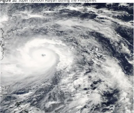
10. Figure 10. Super typhoon Haiyan lashing the Philippines
11. Figure 11. Typhoon Haiyan impacts in the city of Tacloban 12. Figure 12. Structures affected by typhoon Haiyan
13. Figure 13. Observed mean temperature anomalies in the Philippines (1951-2010). Departures from 1971-2000 normal values
14. Figure 14. Five-year frequency of tropical cyclones in Luzon, Vizayas and Mindanao Period: 1949-2013
15. Figure 15. Annual number of tropical cyclones in the PAR Period: 1948-2013 16. Figure 16. Storm surge hazard map – Tacloban city
17. Figure 17. Enforcement of the no build zone after Haiyan 18. Figure 18. Temporary shelters in Tacloban
19. Figure 19. New resettlement area in the north of Tacloban
List of tables
Abbreviations
ADB Asian Development Bank
BPDPP Basic Plan of Disaster Prevention and Protection CC Climate Change
CCA Climate Change Adaptation CLUP Comprehensive Land Use Plan CZO Comprehensive Zoning Ordinance
CMIP5 Coupled Model Intercomparison Project 5 CEPD Council for Economic Planning and Development DEFRA Department for Environment Food and Rural Affairs DUHD Department of Urban and Housing Development DRR Disaster Risk Reduction
EPA Environmental Protection Administration ESPON European Spatial Planning Observation Network FEMA Federal Emergency Management Agency FIRM Preliminary Flood Insurance Rate Maps HLURB Housing and Land Use Regulatory Board
IDNDR International Decade for Natural Disaster Reduction IPCC Intergovernmental Panel on Climate Change KP Kyoto Protocol
MoMA Museum of Modern Art
NASA National Aeronautics and Space Administration NBCP National Building Code of the Philippines
NDRRMC National Disaster Risk Reduction and Management Council NEDA National Economic and Development Authority
NHC National Hurricane Centre
NOAA National Oceanic and Atmospheric Administration NYC New York City
NWS National Weather System
OPARR Office of the Presidential Assistant for Rehabilitation and Recovery PAGASA Philippine Atmospheric and Astronomical Services Administration RPDPP Regional Plan of Disaster Prevention and Protection
SST Sea Surface Temperature WB World Bank
UN United Nations
UNCED United Nations Conference on Environment and Development UNCBD United Nations Convention on Biological Diversity
UNCHE United Nations Conference on Human Environment UNDP United Nations Development Program
UNISDR United Nations International Strategy for Disaster Reduction UNFCCC United Nations Framework Convention on Climate Change
UNOCHA United Nations Office for the Coordination of Humanitarian Affairs UNECE United Nations Economic Commission for Europe
UNHABITAT United Nations Human Settlements Program U.S.A. United States of America
Background
Setting the scene
The scientific community has been studying how climate change affects tropical cyclones and although there is still no full agreement on this relationship, it is certain that tropical cyclones are being influenced by climate variability and change. They are becoming more intense and their impacts more destructive. The risks and consequences of these powerful storms have been affecting communities and leaving behind a trail of damage, coastal erosion and destruction of ecosystems.
Densely populated coastal cities are increasingly being affected by the impacts of extreme tropical cyclones and have to constantly adapt through spatial planning measures that help them in reducing their growing vulnerabilities. Consequently, there is a need for disaster risk reduction (DRR) and climate change adaptation (CCA) measures to be incorporated into spatial planning in order to reduce and anticipate the risk of hazards associated with tropical cyclones such as storm surges and extreme rainfall.
These extreme weather events were responsible for some of the most destructive impacts in recent years, such as tropical cyclones Katrina in 2005 and Sandy in 2012 in the United States of America, Morakot in Taiwan in 2009, and super typhoon Haiyan in the Philippines in 2013. The impacts of these extreme tropical cyclones were such that urgent adaptation actions had to be undertaken to ensure that their effects would be minimized and at the same time promote innovative solutions that would enable communities and cities to become more resilient.
The intensity of the impact of tropical cyclone Haiyan and its storm surge was a tipping point in the Philippines, and to some extent in the rest of the world, in terms of what possibly is yet to come due to the potential influence of climate change. It demonstrated the extent to which coastal populations are exposed to the risks of these extreme weather events and the importance of spatial planning in reducing
their vulnerabilities. These issues will be discussed by this thesis and will be put into context through the effect of Haiyan in the city of Tacloban.
Relevance of the theme of research
Scientists reported that 2015 and 2016 were the warmest years on historical record, breaking what it had been achieved in 2014 (Gillis, 2016). Since the Intergovernmental Panel on Climate Change (IPCC) Third Assessment Report, and due to the possible impacts of climate change, “confidence has increased that some weather events and extremes will become more frequent, more widespread or more intense during the 21st century” (IPCC, 2007b, p. 64). “It is likely that future tropical cyclones (typhoons and hurricanes) will become more intense, with larger peak wind speeds and more heavy precipitation associated with ongoing increases of tropical sea-surface temperatures” (IPCC, 2007a, p.15). With rising temperatures, there is the possibility of an increase of the costs caused by the impact of storms and floods (Stern, 2007).
The consequences of tropical cyclones have been overwhelming in terms of human lives, ecosystems and infrastructure, affecting economies and cities in a way which takes many years to recover. According to the German insurer Munich Re (2011), frequent weather events are responsible for billions of dollars in losses. “Estimates of annual losses have ranged since 1980 from a few billion to above 200 billion USD (in 2010 dollars) with the highest value for 2005 (the year of Hurricane Katrina)” (IPCC, 2012, p.9). The climate change projections for sea-level rise, tropical storm intensity and drought are anticipated to have a disproportionate impact in developing countries situated in the regions around the equator relative to other countries located at higher latitudes (WB, 2013). Asia and the Pacific is the geographical area of the planet that is more affected by the impact of extreme weather events, coupled with a high level of exposure to the impacts by exceedingly vulnerable populations, who are extremely poor and marginalized (ADB, 2012).
The poor are the most affected by these events and who suffer the largest share of casualties, displacement and damages. Due to poverty, people often have no alternatives but to live in the low-lying coastal areas, riverbanks, flood plains, dangerous slopes and degraded urban environments where the impacts of extreme weather events are more severe (ADB, 2012).
Population, migration, and poverty, accompanied by poor land use development and planning, contribute to the increasing number of people who are more exposed to hazards (UNDP, 2012). Cities concentrate the risk to disasters through high population density, inadequate urban planning, and poor infrastructure (Oxfam, 2013). Risks to disasters increase if the exposure of the population and assets to natural hazards grows faster than the ability of countries to improve their risk reduction capacity (UNDP, 2012).
The Philippines is considered the second most exposed country to natural disasters and climate change due to its proximity to the sea and the exposure to tropical cyclones, flooding and sea level rise (UNU-EHS, 2014). This country is hit an average of 20 typhoons per year (PAGASA, 2014) and this century alone it has been affected by some of the deadliest and most destructive on record, including typhoons Ketsana in 2009, Washi in 2011, Bopha in 2012 (NDRRMC, 2012) and most recently Haiyan. The losses caused by these extreme weather events represent 0.8% of the GDP, which could be used in development and poverty reduction efforts of the Philippines (UNISDR, 2012, ADB, 2013). Local communities, ecosystems and water resources are also vulnerable to the passage of tropical cyclones (ICRAF and UNISDR, 2010). Communities suffer a reduction in their livelihoods and often lose agricultural land, worsening their living conditions.
Tropical cyclone Haiyan, made landfall in the Philippines on November 8, 2013 and it was considered as one of most powerful to ever be recorded on the planet (UNOCHA, 2013). This category 5 tropical cyclone was responsible for damages estimated at around a billion USD in agriculture and infrastructure (NDRRMC, 2014). The Haiyan storm surge had a devastating impact on the city of Tacloban, where the majority of the casualties and damage occurred. The impact was worsened by the fact that a lot of
Tacloban coastal area lies below sea level where key public infrastructures had been constructed such as schools, hospitals and private residences (Ranada, 2013). This city, which in the last 50 years was affected by an annual average of 2.3 tropical cyclones, is deemed as one of the most vulnerable cities in the Philippines to climate change (WWF & BPI foundation, 2014).
Purpose and research questions
This thesis will look beyond the cycle of “disaster – rehabilitation – disaster” and the perceived accomplished changes through “quick-wins" (Button et al., 2013). At the same time while recognizing that climate change should be a policy concern beyond typhoon risk management (Pelling and Manuel-Navarrete, 2011) call to “build long term resilience, reduce disaster risk and avoid unmanageable future costs” (World Bank, 2013 para. 6).
Given Tacloban’s vulnerability to the impacts of climate variability and change, the study will consider long-term spatial planning strategies that can reduce the effects of tropical cyclones and “determine the potential for climate adaptation” (Kreimer et al., 2003 cited in Roggema et al., 2012, p. 32) which contribute to anticipate climate change impacts and will only be evident in a “mid to long-term range” (Roggema et al., 2012, p.34). An example of such long term measures is mainstreaming climate and DRR into planning through “climate change-oriented zoning ordinance that takes into account risks and hazards” (Button et al., 2013, p.714).
In this context, the key hypothesis of this PhD research is that if CCA and DRR had been fully integrated in the land use planning strategy of Tacloban before Haiyan, the impacts of this tropical cyclone would have been reduced. Consequently, the future resilience of this city should be based on the mainstreaming of CCA and DRR into its land use plans and its proper implementation.
In order to shed light into this hypothesis in terms of how to reduce the impact of these tropical cyclones through spatial planning, this research will also look into the following questions as a starting point:
1) What are the key vulnerabilities to tropical cyclones in the city of Tacloban and the responses that have been given in terms of future urban resilience?
2) What is the progress in the implementation of the spatial planning strategies that have been put into place after typhoon Haiyan with the objective to reduce exposure and strengthen resilience of the city of Tacloban?
3) Why is it important to undertake social vulnerability assessments in the context of spatial planning in Tacloban and to the communities living in coastal hazard areas?
4) How to mainstream CCA and DRR effectively as policy goals in the land use planning of the city of Tacloban?
This study uses a comprehensive, strategic, participatory and interdisciplinary concept of spatial planning that contributes to increase the adaptive capacity and resilience of urban areas to the impacts of climate variability and change. In the Philippines, the term commonly used is land use planning and it is seen as an approach that could be effective in anticipating and coping with the risks of natural hazards. This is important given the considerable costs of unplanned spatial development structural actions. It also assists in providing a framework to mainstream CCA and DRR at local government level development plans (HLURB, 2015).
Research methodology and presentation structure
In the 1st chapter, titled Introduction, summary information will be provided to set the scene for this
research in terms of the significance of the topics to be studied such as the scientific aspects of climate change and its potential influence on tropical cyclones, the role of spatial planning in reducing hazard risks, the impacts of extreme tropical cyclones Katrina and Sandy in the United States of America and Morakot in Taiwan. Likewise, the importance and implications of the impact of tropical cyclone Haiyan in the Philippines, which will be the case study of this research and whose impacts will be put in perspective with the other extreme tropical cyclones. This chapter will also introduce the research
questions that will be contextualized with the study and with what it expects to achieve. Lastly it will provide a justification of the structure of this thesis and its methodology.
The 2nd chapter, titled Tropical cyclones and climate change, will look into the formation of these extreme
events around the world and the potential influence of climate change in tropical cyclone activity. This issue became an area of concern that has been widely debated and analysed by the scientific community and has been reflected by the International Panel on Climate Change. This is particularly relevant when recent extreme tropical cyclones such as Katrina, Sandy, Morakot and Hayan have exposed a number of vulnerabilities and left a degree of uncertainty about the intensity of future tropical cyclones. The study will also contextualize the impacts of climate change with the Paris Agreement as a commitment from the international community towards reduction of carbon emissions and a climate resilient world. This chapter will examine the scientific explanation of tropical cyclones, the evolution of the scientific discussion on the influence of anthropogenic climate change in tropical cyclones, and the way forward to address the impacts of climate change.
The 3rd chapter, entitled Spatial planning as an adaptation option to climate change and tropical cyclones,
will consider the growing vulnerability of cities located in coastal areas to the effects of climate variability and change. Even though it is not yet possible to fully understand the influence of climate change on tropical cyclone activity, the risks and impacts of these extreme weather events are such that it is necessary to look into spatial planning adaptation measures to reduce and anticipate these impacts. This is particularly relevant to developing countries, because people often move to hazard prone areas due to factors linked to lack of available and affordable land and also due to the inefficacy of local authorities to undertake multi-hazard assessments and zone these areas to prevent communities from settling there.
For Godshalk (2003, p.137) “(…) resilient cities would be built on principles that derive from past experiences with disasters in urban areas”. Bearing this in mind, this chapter will discuss the importance of spatial planning in influencing the separation of hazard-prone zones and the development areas, it
will also study the urban vulnerability to climate related disasters, specifically tropical cyclones, and how spatial planning has been addressing and integrating CCA and DRR. In this context, it will analyse the importance of spatial planning policy instruments, such as zoning and building codes. This chapter will also review the role of financial incentives in increasing resilience of people and assets and how innovative design solutions are being used to improve the integration of the cities with nature and the oceans.
In the 4th chapter, titled Spatial planning responses to the impact of tropical cyclones in the United States
of America and Taiwan, will look at these extreme events and their growing impact in terms of human lives, environment and infrastructure, which leave a profound impact on the economies of both developed and developing countries. In this context, it is important to assess the cities and places affected by tropical cyclones Katrina, Sandy and Morakot and their pre-existing vulnerabilities that have contributed to the massive infrastructure damage and casualties. The objective is to analyse the poor climate adaptation planning from central and local governments in making the necessary investments and strategies towards climate resilient infrastructures that could have minimized and anticipated the impacts of these tropical cyclones.
Due to the different technological capacities as well as financial and human resources in the United States, Taiwan and the Philippines, it is important compare to their capacity to adapt to the vulnerabilities in terms of planning responses to become more resilient. The analysis will also include the relocation strategies undertaken by Taiwan and the Philippines as post-disaster reconstruction and their impact on communities.
This chapter will study the different effects of tropical cyclones Katrina, Sandy and Morakot and the vulnerability of populations that were living in the hazard-prone areas. It will also review the spatial planning measures that these extreme events have triggered and their limitations in terms of recovery. Lastly it will take into consideration the role and participation of local communities in the planning process.
The 5th chapter, titled The impacts of typhoon Haiyan in the Philippines: Implications to land use planning
will discuss the case study1 of this thesis which will analyse the impact of the extreme tropical cyclone
Haiyan and its storm surge that was responsible for a high number of casualties and devastated the city of Tacloban in the Philippines. Since this place is often battered by tropical cyclones, the study will look into policy gaps that may have contributed to its weak planning given the unpreparedness of this city. Furthermore, the case study will review the city’s Comprehensive Land Use Plan (CLUP) which had been adopted in May 2013, but had not been implemented when Haiyan hit Tacloban, to understand what type of adaptation measures for storm surges, floods and sea level rise had been planned and if they had been put in place would they have made any difference. Although mainstreaming climate is a policy decision, the CLUPs seldom integrate DRR and CCA which are often seen as a requirement instead of a planning instrument. This raises some questions regarding possible implications to the city of Tacloban, such as lack of capacity to integrate CCA and DRR in the land use planning and political commitment. One aspect that will be taken into consideration in this research is the analysis of governments’ capacity and their ability to legislate and implement effectively. Another issue is poverty and people moving to and living in hazard prone areas, such as river banks and coastal areas. It is important to analyse the current policies both at central and local level that contribute to develop in hazard-prone areas. This case study will review the climate trends in the Philippines and will analyse planning by the local governments before and after Haiyan. In addition, it will review the legal and institutional framework to address climate change and disaster risk reduction and management, the national building codes, the Comprehensive Land Use Plans, the process of recovery and reconstruction, zoning for hazards and the resettlement after Haiyan. This case study will also be part of a vulnerability assessment of selected typhoon affected areas.
1 This case study/paper was published online on the 2nd of January 2016 in the Climate, Disaster and Development Journal
In the 6th chapter, named Conclusion, this thesis will provide concluding remarks as well as suggestions
for possible issues to be studied in the future.
All in all, this study intends to contribute towards the discussion on more effective ways to include climate change adaptation and disaster risk reduction into spatial planning. In particular, reducing the risks of future extreme tropical cyclones in coastal areas and to provide recommendations that can be applied to Tacloban in terms of medium and long term climate resilient communities and infrastructure that are based on the exposure of other nations and lessons learned from the impact of tropical cyclones.
Objective
Tropical cyclones and their adverse impacts have been known to mankind in areas closer to the equator and as a result of climate variability. These extreme weather events originate in seven basins around the world and are particularly active in the Atlantic and Northwest Pacific.
With the advent of anthropogenic warming last century, tropical cyclones became an area of study to determine if there was a potential influence of climate change in their frequency and intensity. Since the first assessment report of the IPCC, scientific evidence has been sought to support this possibility. Initially and due to the effects of global warming not being strong enough to be noticed, it was difficult to substantiate the potential link. With a growing population and infrastructure being increasingly more affected by the impacts of powerful tropical cyclones globally, more studies were undertaken to understand if there was an influence of climate change on tropical cyclone activity.
Although it is difficult to say that the impacts of tropical cyclones are uniquely attributed to effects of global warming, these are being influenced by climate variability and change. This century alone a number of extremely powerful tropical cyclones such as Haiyan in the Philippines, Katrina and Sandy in the United States as well as Morakot in Taiwan have affected countries and territories devastating people’s lives and assets.
The projected increase in sea surface temperature as a result of climate change will contribute to intensify tropical cyclones, which combined with the anticipated sea level rise will further aggravate the impact of storm surges in low-lying coastal areas. This is particularly worrisome as the planet is getting warmer when we take in consideration the record breaking temperatures in 2014, 2015 and 2016. Recent studies foresee a slight decrease in the frequency of tropical cyclones but with an increase in their intensity and producing more rainfall (Knutson et al, 2015).
Efforts by the international community such as the Paris Agreement2 are an attempt to maintain the
increase in temperature to below 2°C and limit the temperature rise to 1.5°C, which can contribute to reduce the effects of climate change.
In this context, this chapter will address i) the scientific explanation of tropical cyclones; ii) the evolution of the scientific discussion on the influence of anthropogenic climate change in tropical cyclones, and; iii) the way forward of the international community to address the impacts of climate change.
Impacts of recent severe tropical cyclones in different geographic basins
Every year between 80 to 100 tropical cyclones develop worldwide and many make landfall causing casualties, economic losses and infrastructure damage and destruction (Met Office, 2016b). According to the IPCC (2012) report on “Managing the Risks of Extreme Events and Disasters to Advance Climate Change Adaptation” (SREX, p.16), the “increases in exposure will result in higher direct economic losses from tropical cyclones. Losses will also depend on future changes in tropical cyclone frequency and intensity (high confidence)”
Some notable examples of recent category 5 tropical cyclones worldwide include tropical cyclone Winston which made landfall in the Islands of Fiji in February 2016 and which was the strongest on record in the southern hemisphere with estimated sustained winds of 289 kph (Erdman, 2016). This category 5 tropical cyclone was responsible in this island country for 42 casualties and an estimated $1, 42 billion in damages and losses (Asian Development Bank, 2016; Cullinane & Ap, 2016). It was the second consecutive year that a category 5 tropical cyclone hit this South Pacific region, after tropical cyclone Pam hit the islands of Vanuatu in March 2015 with sustained winds of 265 kph (Erdman, 2016).
Patricia was one of the most severe tropical cyclones that made landfall in Mexico in October 2015 and it was the strongest ever recorded in the Western Hemisphere with 322 kph winds, but given the low population density in the area closer to the tropical cyclone landing, the casualties and damage were reduced. In 2013 Typhoon Haiyan struck the Philippines and was considered as one of the strongest ever to make landfall in the planet with winds reaching 315 kph (UNOCHA, 2013; Mullen, 2013). This category 5 super-typhoon was responsible for a high number of casualties as well as economic and infrastructure damages.
Hurricane Katrina was another noteworthy category 5 tropical cyclone. It struck the New Orleans area in the United States in August 2005 and had a major impact in terms of human lives, ecosystem services and infrastructure as well as with the fishing and agricultural industry (Richard et al., 2005). Katrina was responsible for the death of more than 1800 people and the economic costs amounted to about 100 billion dollars, thousands of homes and businesses were destroyed and damaged as well as government infrastructure, sites of cultural and historical interest and oil refineries (Richard et al., 2005). Katrina also had an impact on the loss of coastal marshes, damage to dikes and reduction of island areas (Barras, 2007).
Formation and characteristics of tropical cyclones
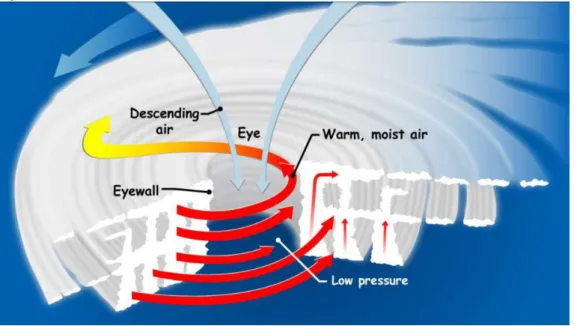
A tropical cyclone is an intense circular storm. It is the broad term used for “low-pressure storm systems that form in tropical latitudes on either side of the Equator. Cyclones are characterized by thunderstorms, large waves, and powerful winds that rotate around a centre of upwelling air” (NOAA, 2010, para. 1). Several elements are needed to fuel tropical cyclones engine such as warm ocean waters and moist air (NASA, 2016a).
There is an eye in the centre of tropical cyclones (Figure 1). It is characterized by weak winds (normally below 24 kph and 32 to 64 kph across) and mild weather and with almost no rainfall (Landsea, 2011; NOAA, n.d.) The eye is the most tranquil area of the storm and it is generated once wind speeds exceed
Figure 1: Structure of a tropical cyclone
Image credit: NASA (2016a)
This weather phenomenon is about eight to almost ten km high and typically between 100 to 2,000 km in diameter with sustained wind speeds (Met Office, 2016a; NASA, 2014; WMO, 2014). In addition to the strong winds, tropical cyclones are accompanied by torrential rains, storm surges, high seas, and sometimes tornadoes (WMO, 2014). When it is at its initial and weak stage, is called a tropical depression and its winds can reach up to 61 kph. It then evolves into a tropical storm when its sustained winds reach 63 kph and it becomes a tropical cyclone when the sustained winds reach 119 kph or more (Met Office, 2016a: National Hurricane Centre, n.d.1).
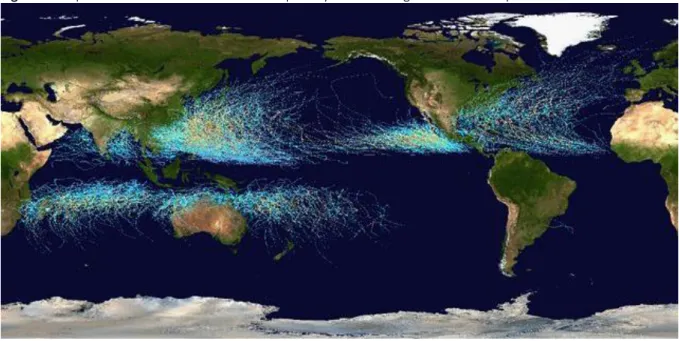
The National Oceanic Atmospheric Administration’s (NOAA) National Hurricane Centre (n.d.1) estimates that 69 per cent of the tropical cyclones hit the Northern Hemisphere and around 31 percent strike the Southern Hemisphere. Around 57 percent hit the Pacific Ocean, 31 percent the Indian Ocean and only 12 percent occur in the Atlantic Ocean (Figure 2).
Tropical cyclones in the northern hemisphere form around June to November, reaching a peak in September, whereas in the southern hemisphere the season goes from November to April though tropical storms remain not as common as in the northern hemisphere (Met Office, 2015a).
Figure 2: Map of the cumulative tracks of all tropical cyclones during the 1985-2005 period
Source: NASA, (2009a).
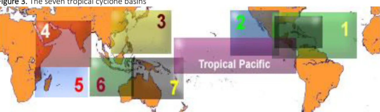
Tropical cyclones usually form in seven ocean basins at different times of the year and are occasionally referred to as seasons (Met Office, 2015a). The following are the seven basins (Figure 3): 1 - The Atlantic basin which include the North Atlantic Ocean, the Gulf of Mexico and the Caribbean Sea - the season occurs from June to November. 2 - Northeast Pacific basin comprising of Mexico to approximately the international Date Line - the season occurs from late May to early June and from late October to early November. 3 - Northwest Pacific basin starting from the international Date Line to Asia and the South China Sea - the season occurs all year round but the main season is from July to November. 4 - North Indian basin, which includes the Bay of Bengal and the Arabian Sea - the season occurs from April to December. 5 - Southwest India basin, from Africa to almost 100E - the season occurs from late October to early November and until May; 6. Southeast Indian/Australian basin, from 100E to 142E - the season occurs from late October to early November and until May, and lastly 7 - Australian/Southwest Pacific basin, from 142E to about 120W - the season occurs from late October to early November and until May (Met Office, 2015a; AOML/NOAA, n.d.).
Figure 3. The seven tropical cyclone basins
Source: Atlantic and Oceanographic Meteorological Laboratory/National Oceanic and Atmospheric Administration (n.d.)
Tropical cyclones form at 5° - 30° latitude from the Equator and are named differently over the Oceanic regions (Figure 4). In the North Atlantic Ocean, central and eastern North Pacific, Caribbean Sea and Gulf of Mexico they are referred as “hurricanes”. In the Northwest Pacific, they are called “typhoons”, in western South Pacific Ocean and southeast Indian Ocean as “severe tropical cyclones”, in the southwest Indian Ocean they are called “tropical cyclones”, in the Bay of Bengal and Arabian Sea as “cyclones” and in the western South Pacific and southeast Indian Ocean as “severe tropical cyclones” (Met Office, 2016; Stillman, 2014; WMO, 2014).
Figure 4: Tropical cyclone regions around the world
Source: NASA (2016a).
The winds that converge from northeast and southeast on the Equator as a result of the Coriolis effect are called the trade winds. The Inter-Tropical Convergence Zone (ITCZ) is formed by the convergence of these trade winds which forces the air to raise into the atmosphere (Peixoto & Oort, 1992; NOAA, n.d.).
The ITCZ results from the higher solar radiative received per unit area at the surface of the Earth in the equatorial area. The resulting air uplift in this region generates high precipitation and the trade winds (National Weather System, 2010). The ITCZ corresponds to the ascending sections near the Equator of the two Hadley cells. It moves North and South of the Equator following the movement of the sun's annual cycle, producing a band of intense rain and thunderstorms (Santos, F.D., 2012a). The convergence of the trade winds also triggers tropical cyclones (Graham & Riebeek, 2006).
The energy source of tropical cyclones arises from the in-situ evaporation of ocean water (Emanuel, 1987). Tropical cyclones originate in tropical warm waters with moist air, where the ocean surface and air temperature is above 26⁰C. Another important factor is the development of storm clouds which are a result of the winds that converge close to the sea surface causing the air to ascend (Landsea, 2004; Met Office 2016).
Figure 5: Storm surge
Image credit: NOAA/The COMET program (NOAA, n.d.)
When the air flows upwards, 90% of the energy that is stored is freed by condensation ascending to the towering cumulus clouds and rain (Met Office, 2016). This process let the storm clouds to climb straight up to high levels. The Coriolis force is extremely important in this process because the Earth’s rotation facilitates to spin of the column of ascending air. Lastly and in order to be able to spin or twist tropical cyclones need enough distance from the Equator (NOAA, 2014; PAGASA, 2014; Met Office 2016). When these powerful weather systems path strike land, they usually generate a storm surge (figure 5)
which is an uncommon rise in sea level different from the normal tides, that, when combined with heavy rain can cause massive floods. (Met Office, 2014; Stillman, 2014; NOAA, 2016a).
When tropical cyclones reach land, they decline because their power supply is reduced and the friction with the terrestrial surface changes the air stream causing the tropical cyclone to dissipate (Met Office, 2016).
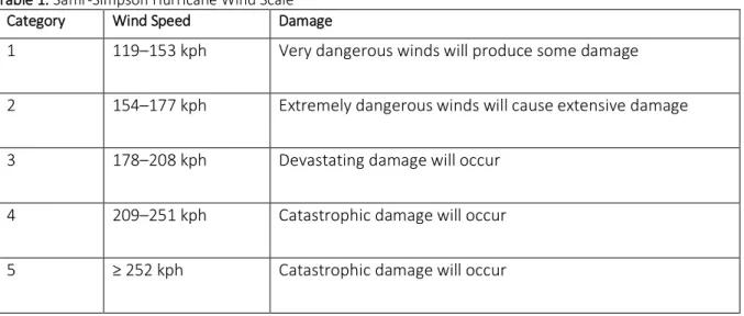
In order to measure the intensity of tropical cyclones, they are ranked according to the Saffir-Simpson Wind Scale. This Scale is rated from 1 to 5 (table 1) and it is based on the sustained wind speed of a tropical cyclone.
Table 1: Saffir-Simpson Hurricane Wind Scale Category Wind Speed Damage
1 119–153 kph Very dangerous winds will produce some damage 2 154–177 kph Extremely dangerous winds will cause extensive damage 3 178–208 kph Devastating damage will occur
4 209–251 kph Catastrophic damage will occur 5 ≥ 252 kph Catastrophic damage will occur
Source: NHC/NOAA ( n.d.1).
Though it was developed in the U.S. it is also used in other regions of the globe. According to the NOAA’s National Hurricane Centre (NHC) (n.d.1) storms that are ranked 1 and 2 are considered to be dangerous and will need precautionary measures but once they reach Category 3 or above they will be regarded as major tropical cyclones given their potential for considerable casualties and property damage. Tropical cyclones with sustained winds higher than 241.4 kph are designated as “Super Typhoons” in the western North Pacific basin (National Hurricane Centre/National Oceanic and Atmospheric Administration, n.d.1).
According to NOAA’s National Weather System (2012) the Saffir-Simpson scale only uses peak winds and does not consider “storm surge ranges, flooding impact and central pressure statements”.
Given the progress in weather prediction models, the forecast of early occurrence of tropical cyclones has improved significantly in recent times. Regional centres like the NHC are responsible for the forecast of the tropical cyclones in the affected zones (Met Office, 2016).
The names of tropical cyclones are chosen to help improve communication among weather forecasters and to make it simpler for the media to report activity of tropical cyclones as well as for the public to improve its awareness and to remember tropical cyclones in their region, thus facilitating early warning and community preparedness (Met Office, 2016; WMO, n.d.). Given that storms can frequently continue for more than a week and also more than one tropical storm can be happening in the same area during the same period, providing names to tropical storms helps reduce misunderstandings about which one is being designated (Met Office, 2016; WMO, n.d.). Names are given using a predetermined list arranged alphabetically with alternate male and female names, in the north-west Pacific Basin the system uses a combination of personal names, flowers, animals, birds, trees, foods or adjectives and are given not in alphabetic sequential preference but according to the contributing naming country (Met Office, 2016; WMO, n.d.).
The potential influence of climate change on tropical cyclones
As a result of global warming the temperature of the planet oceans have been increasing, causing water to expand and glaciers and ice sheets to melt, triggering sea level rise. This has an effect on tropical cyclone storm surges which inundate much further inland than before, becoming more extreme and harmful to populations in coastal areas (NOAA, 2016b).
According to observations dating back to 1961, the ocean has absorbed over 80% of the existing heat in the climate system. This overall increase in the average temperature has led to an increase in sea surface temperature (SST) (IPCC, 2007a). The increase in sea surface temperature and the consequent water evaporation into the atmosphere contribute to the intensification of tropical cyclones (Trenberth, 2007). Globally, estimates of the potential destruction of tropical cyclones show a significant upward
trend since 1970, and this trend is correlated with SST (Elsner et al., 2008; IPCC, 2007a; Kossin & Camargo, 2009; Trenberth, 2007).
The IPCC and the scientific basis of the potential influence of climate change on tropical cyclones
Climate change may be one of the largest challenges of the 21st century (Deryugina 2012; IPCC 2007). However, it only became a concern of the general public in 1988 after the United States of America (USA) experienced a year earlier, the hottest year on record (Deryugina 2012). The IPCC was created in that year with the aim of providing “the world with a clear scientific view on the current state of knowledge in climate change and its potential environmental and socio-economic impacts” (IPCC, n.d.). The IPCC is the biggest scientific network of human history, concentrating its work on the exchange and validation of worldwide information about the climate (Soromenho-Marques, 2009).
In order to address some of the world’s global environmental problems (Soromenho-Marques, 2005), the international community, through the United Nations (UN), promoted two key international conferences that would be crucial and would become a turning point in environmental diplomacy, notably the United Nations Conference on Human Environment (UNCHE) in 1972 and the United Nations Conference on Environment and Development (UNCED) in 1992 (Soromenho-Marques, 1998). The UNCED conference, also called the Earth Summit, was responsible for two important outcomes, the United Nations Framework Convention on Climate Change (UNFCCC), which provides a platform for international cooperation on climate change and the United Nations Convention on Biological Diversity (UNCBD) that aims at conserving the biodiversity on the planet (UNCED, 1992; UNEP, 1992).
As part of the global efforts to raise the profile and awareness on climate change, two significant works were released in 2006 with large media interest and coverage, namely “The Economics of Climate Change” by Nicholas Stern (2007) and “An Inconvenient Truth” a documentary by the former Vice President of the US, Al Gore. Both were influential in shaping public policy with an invigorated drive to the urgency to fight climate change (Soromenho-Marques, 2011). In his report, Stern (2007, p. iv) stated
that “the scientific evidence is now overwhelming: climate change is a serious global threat, and it demands an urgent global response”.
There is, today, a broad scientific consensus that anthropogenic global warming is a threat
which
justifies action (IPCC 2007; Rosenberg et al. 2010; Deryugina 2012). According to Rosenzweig et al., (2011) in the short and medium term cities will experience the effects of climate change through an increased variability and change of extreme weather events frequency and intensity.
In this context, the IPCC have played an important role through the assessment reports which have been published every five years since 1991 and have contributed to the scientific debate on climate change and its potential influence on tropical cyclones.
The IPCC First Assessment Report
The potential influence of climate change on tropical cyclones has been an object of study since the IPCC First Assessment Report (FAR) in 1990. The IPCC FAR, questioned if, in the last century there had been an increase in the frequency and intensity of the tropical cyclones due to global warming, and concluded that “current evidence does not support this idea perhaps because the warming is not yet large enough to make its impact felt” (IPCC, 1990, p.232).
This conclusion was supported by the fact that since 1970 the frequency of tropical storms had decreased in the North Indian Ocean whilst the SST had risen in this region more than in other places. It further added that in spite of the increase of tropical cyclone frequency registered since 1950 in the eastern North Pacific, the southwest Indian Ocean and in the Australian region, this increase was probably due to improved monitoring measures. According to this report, in the North Atlantic and western Pacific Oceans the availability of information of wind speed did not indicate a change in the intensity of tropical cyclones (IPCC, 1990).
The Kyoto Protocol
In order to limit greenhouse gas emissions (GHG), and its associated risks, the UNFCCC negotiated, in 1992, the basis for the Kyoto Protocol (Daskalakis et al. 2009; Teixeira et al. 2008/2009). On the 11th of
December 1997, the Kyoto Protocol was adopted but it only entered into force on February 2005 as a result of the complexity of the ratification process (UNFCCC, 2014). The Kyoto Protocol was meant to operationalize the Convention on Climate Change and established binding emission targets for 37 industrialized countries and the European Union (UNFCCC, 2014a).
It was a voluntary agreement where parties of the Annex I (industrialized countries) of the Protocol agreed to reduce their overall GHG emissions by 5% below 1990 levels, over the first commitment period of 2008 to 2012 (UN, 1998; Teixeira et al. 2008/2009; UNFCCC, 2013; UNFCCC, 2014a). The Kyoto Protocol was only binding for developed countries given the fact that it acknowledged their responsibility for the existing levels of GHG emissions, which are a consequence of more than 150 years of industrial activities. The Kyoto Protocol has put a stronger responsibility on developed countries under the principle of “common but differentiated responsibility” (UNFCCC, 2014a para. 4).
The Kyoto Protocol established four mechanisms that parties use in order to comply with their GHG reduction goals: (i) carbon-trading schemes, (ii) the Clean Development Mechanism (CDM), (iii) the Joint Implementation system (JI) and (iv) investments in funds managed by independent third parties (Teixeira, 2010). The EU-ETS is one such mechanism (Haar & Haar, 2006; Schwaiger et al, 2012). The EU-ETS is a cap-and-trade system involving over 25 nations and 9,000 installations across the European Union (EU) and is designed to achieve emission reduction targets in an effective and efficient manner by recognizing that abatement costs are not uniform and that compliance costs are met at a minimum cost by trading allowances, (EC, 2006; Haar & Haar, 2006; Daskalakis, 2013). In fact, it was expected that the EU-ETS would allow the EU to achieve its emission reduction target at a cost below 0.1% of GDP (EC, 2006).
The EU-ETS is composed of three phases: (i) phase 1, which ran from January 2005 to 31 December 2007, was a pilot phase in order to allow participants to prepare for phase 2; (ii) phase 2, ran from 1 January 2008 to 31 December 2012 refers to the first commitment period of the Kyoto Protocol; and (iii) phase 3 which begun in 1 January 2013 and will go on until 31 December 2020 which plays a central role in allowing the EU to achieve the goals of its climate and energy targets by 2020 (EC, 2006; Schwaiger et al, 2012). Although only businesses who are obliged to participate in the EU-ETS are given allowances, the market allows for any agent (e.g., individuals, institutions, etc.) to buy and sell in the market (EC, 2006).
The second commitment period from the first of January 2013 to 2020 was adopted in Doha, Qatar on 8th December 2012, in what was designated as the Doha Amendment (UNFCCC, 2014b). For this period,
it is expected that from 2013-2020 there would be a reduction of 18 per cent in the GHG emissions bellow 1990 levels by the Parties (UNFCCC, 2014b).
The IPCC Second Assessment Report
When the IPCC Second Assessment Report (SAR) was published in 1996, it acknowledged that there was still not enough information to determine if there would be changes in the occurrence or geographical distribution of tropical cyclones (Houghton et al. 1996). According to Gray (1990), cited in the SAR (1996), the hurricane (tropical cyclone) activity in the Atlantic was more intense from 1947 to 1969, when compared with the period of 1970 and 1987. The western North Pacific registered during the same period of time an identical decline in the number of intense of tropical cyclones (IPCC, 1995). This difference in the intensity of tropical cyclones in the Atlantic and North Pacific was due to a change in the wind speed measurement methodology in 1970 and the consideration of the correlation with sea surface temperature (Bouchard, 1990; Black, 1992; Landsea, 1993 cited in IPCC 1996).
The weaker tropical cyclone activity periods could also be a result of the El Niño events (Houghton et al. 1996). Nevertheless, the IPCC (Houghton et al. 1996, p.170) cautioned, “doubts about the quality and
consistency of the data on maximum wind speeds in most cyclone basins preclude convincing analysis of how peak cyclone intensity might have changed in recent decades. Only in the Atlantic do the data seem of sufficient quality to allow such an analysis”.
For the SAR (Houghton et al. 1996), it was not easy to predict tropical cyclone changes due to global warming. The Global Circulation Models (GCMs) of that time could not satisfactorily simulate the tropical cyclones, or some aspects of the El Niño Southern Oscillation (ENSO), as well as the large-scale changes in the atmospheric general circulation that could potentially influence the tropical cyclones. In addition, the fact that the tropical storms have such a considerable natural variability that any small trends could easily be missed (Houghton et al. 1996). The IPCC (Houghton et al. 1996, p.290) added that “the formation of tropical cyclones depends not only on sea surface temperature (SST), but also on a number of atmospheric factors. Although some models now represent tropical storms with some realism for present day climate, the state of the science does not allow assessment of future changes”. A study undertaken by Holland (1995) and cited by the IPCC SAR (1996) suggested that in present climate conditions, it was doubtful that there would be tropical cyclones more intense than the ones experienced so far. However, in regions where the SST was between 26⁰ and 29⁰C, there was potential for change in the intensity of tropical cyclones. The IPCC SAR (Houghton et al. 1996, p.334) concluded that “it is not possible to say whether the frequency, area of occurrence, mean intensity or maximum intensity of tropical cyclones will change”.
The IPCC Third Assessment Report
The IPCC Third Assessment Report (TAR) (Folland et al, 2001) was released in 2001 and reviewed the changes related to intensity and frequency of weather events. However, it emphasized the fact that intense tropical cyclones are rare and therefore the study of large zones as well as extensive consistent records of tropical cyclones are needed to evaluate possible changes. Nevertheless, the TAR concluded that this data combination was not yet available. The TAR assessed the confidence in the observation and expected changes in extreme weather and climate events. It concluded that regarding the “increase