Estimation of Irrigation Water Pumping by Remote Sensing: Application
of the SAMIR Model to Citrus under Mediterranean Climate Conditions
Idir Tazekrit
1, Mohamed Benslimane
1, Vincent Simonneaux
2,3, Tarik Hartani
4,
Abderrahmane Hamimed
11
Research on Biological Systems and Geomatics Laboratory,
University Mustapha Stambouli of Mascara, Algeria.
2
Mixed-Laboratories-International Remote Sensing and Water Resources in the Semi-Arid
Mediterranean of Marrakech, University Cadi Ayyad, Marrakech, Morocco.
3
Center for Space Studies of the Biosphère, University of Toulouse, CNRS, CNES, IRD, UPS,
Toulouse, France.
4
University Center of Tipaza, Tipaza, Algeria
Received in December 5, 2017 – Accepted in May 13, 2018
Abstract
Agricultural intensification has led to overexploitation of water resources, in particular of the underground resource. Es-timating groundwater exploitation remains a serious problem in arid and semi-arid countries such as Algeria. The objec-tive of this work is to estimate volumes of pumped irrigation water using the SAtellite Monitoring of Irrigation (SAMIR) model from satellite imagery. Eleven (11) Landsat-TM images covering an area of 20 hectares of citrus orchards with a drip irrigation system were used. Irrigation volumes simulated by SAMIR were compared with volumes of pumped irri-gation water. The latter were recorded digitally by specific programmers over a one-year observation period. The results shows a slight discrepancy between total simulated and observed volumes, 138,782 m3and 135,688.5 m3, respectively.
The index of agreementdandRMSEwere 80.94 and 0.11, respectively, while the ratio of observed to simulated volumes varied from 0.76 to 1.27. 65% of the values compared differed by less than 10%. A significant correlation was found be-tween the two methods. This confirms the feasibility of estimating pumping by remote sensing without calculating theo-retical crop water requirements.
Keywords:irrigation, remote sensing, water balance, water pumping, SAMIR, FAO-56.
Estimativa do Bombeamento de Água para Irrigação Através de Deteção
Remota: Aplicação do Modelo SAMIR à Cultura de Citrinos sob
Condições Climáticas Mediterrâneas
Resumo
A intensificação da agricultura levou à sobreexploração de recursos hídricos, em particular os recursos subterrâneos. A dificuldade na sua estimativa continua a ser um problema sério em países como a Argélia. O objetivo deste trabalho é estimar o bombeamento de água agrícola através do modelo SAMIR (SAtellite Monitoring of IRrigation), com base no uso de imagens de satélite. Foram utilizadas onze (11) imagens Landsat-TM que abarcam uma área de 20 hectares de citrinos irrigados com sistema de gota a gota. As irrigações simuladas pelo SAMIR são confrontadas com as irrigações resultantes do bombeamento. Estes últimos foram gravados digitalmente por programadores específicos durante um período de observação de um ano. Os resultados mostram uma discrepância ligeira nos volumes totais simulados e observados, respectivamente de 138782 m3e 135688,5 m3. O índice de concordância
deRMSEsão respectivamente
80,94 e 0,11, enquanto a relação entre observações e simulações varia de 0,76 a 1,27. 65% dos valores comparados têm diferenças inferiores a 10%. Os métodos utilizados mostram uma correlação significativa. Isso confirma o nível de relevância da estimativa de bombeamento pelo método de sensoriamento remoto, sem calcular os requisitos teóricos de água das culturas.
Palavras-chave:irrigação, modelação, deteção remota, balanço hídrico, SAMIR, FAO-56. Review
1. Introduction
In arid and semi-arid regions, the availability of water is the main limiting factor to plant productivity. Sustainable water management is a major problem, especially in irri-gated areas. In such areas, tools that provide regional esti-mates of water balance components, particularly evapo-transpiration, which is the main component of the water budget, will enable more sustainable management of water resources. Satellite remote sensing has great potential for monitoring agricultural water resources at different spatial and temporal scales. Remote sensing provides images ac-quired at regular intervals covering large geographical ar-eas plus enables monitoring of vegetation dynamics throu-gh vegetation indexes (such asNDVI) and the detection of
the water status through the land surface temperature, both of which are crucial factors controlling evapotranspiration. Methods based on remote sensing that make it possible to estimate the quantity of water in the soil at each instant have already been validated (Toureiroet al., 2016), making it
possible to determine the water requirements of different crops (Allenet al., 1998). Water transpired from plants is
closely linked with the normalized difference vegetation index (NDVI) (Choudhuryet al., 1994; Bausch, 1995). The NDVIallows theKcbcoefficient (Basal crop coefficient) to
be derived from satellite images and evapotranspiration to be calculated. The relationship betweenNDVIandKcbhas
been the subject of many studies, (e.g.Michael and
Bas-tiaanssen., 2000; Nealeet al., 2005; Gonzalez-Dugoet al.,
2009; Allenet al., 2011). Toureiroet al.(2016) showed a
linear relationship between changes in theNDVIand
vege-tation coefficients over time. Calculating evapotranspira-tion enables crop water requirements to be estimated and hence the volume of water used by farmers. Groundwater, which is considered by farmers? as an individual resource (Margat, 2008), has resulted in several million drill holes around the world (Shah, 2009). In North Africa, groundwa-ter is overexploited by more than 50% (Kuperet al., 2016).
Estimating pumped water remains problematic and invol-ves considerable uncertainty (Margat, 2008). Many meth-ods are available to estimate pumped volumes, often based on direct measurements (flowmeters) or theoretical crop re-quirements and statistics, or remote sensing combined with the theoretical needs of crops that can be adjusted by cor-rection coefficients (Castaño et al., 2010; Wada et al.,
2012). According to Blinda and Thivet (2006), agriculture accounts for up to 80% of total water demand in southern and eastern Mediterranean countries. In Algeria, ground-water is the resource the most threatened by agricultural de-velopment (Siebertet al., 2010). Algeria is one of the main
regions in the world where groundwater is used for inten-sive agriculture, and the extraction of groundwater, which has been qualified as an informal revolution, often takes place outside public policy (Siebertet al., 2010).
In Algeria, the exploitation of renewable under-ground resources (ratio of withdrawal to recharge) is high.
In 2011, the average exploitation rate was calculated to be 80% (Faysseet al., 2011), evidence for the overexploitation
of most large aquifers, such as those in the plain of Mascara and the plateau of Mostaganem (Faysseet al., 2011).
Cas-tañoet al.(2010) claim there is no method of accurately
quantifying such withdrawals that also satisfies the need for precision and low application cost over large areas. Eva-potranspiration is considered to be the main flow in the hydric balance in these areas (Poussinet al., 2008). This
pa-rameter is usually estimated using remote sensing data, based on the estimation of surface energy using instanta-neous thermal imaging at the moment of passage of the sat-ellite (Deloguet al., 2012). These methods do not allow
validation of the estimated soil surface temperatures and hence the extrapolation of evapotranspiration (Chirouze
et al., 2014). Here, we use the soil vegetation atmosphere
transfer (SVAT) to simulate evapotranspiration, using re-mote sensing data combined with monitoring of soil mois-ture. The FAO-56 dual crop coefficient method is the most widely used approach for estimating crop water require-ments (Allenet al., 1998). It distinguishes between plant
transpiration (Kcb) and soil evaporation (Ke). Soil
evapora-tion (Ke) is related to the fraction of vegetation cover (Fc)
(Hueteet al., 1985). The latter can be linearly linked to the Kcbof plants (Choudhuryet al., 1994).
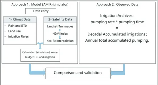
The SAMIR model used in this study allows spatial simulation of evapotranspiration and crop water needs at the plot scale. Model inputs are evapotranspiration and lo-cal rainfall data, and a chronologilo-cal series ofNDVI, with medium resolution (Landsat 8). Combining remote sensing with the FAO-56 model provides actual information on the vegetative state (KcbandFc) (Saadiet al., 2015). The main
objective of present work was to develop a methodology based on the SAMIR approach to estimate hydrological variables, such as evapotranspiration and irrigation vol-umes from regional aquifers intended for agriculture under semi-arid climates. The reliability and precision of the model was evaluated by comparing simulated pumped and measured pumped volumes. However, other possible appli-cations are estimation of citrus water requirements in se-mi-arid Mediterranean conditions, and the relationship test (Kcb) as a function of the vegetation index (NDVI) for
cit-rus.
2. Materials and Methods
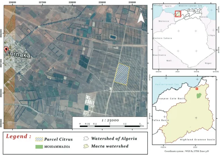
2.1. Study area
The Macta watershed is located in western Algeria (Fig. 1), between latitudes 34°28’N and longitudes 35°87’N and 0°52’W and 1°2’E. It is drained by two main valleys, Wadi El Hammam, drains the northeastern slope of the Tellian Atlas, and Wadi Mebtouh the western slopes.
The climate in this area is semi-arid Mediterranean, characterized by a rainy season in the autumn and a hot dry season in the summer. The absolute minimum air
ture in winter is 6 °C to 8 °C. The absolute maximum tem-perature is 42 °C. The average annual rainfall is 260 mm (Glizet al., 2015). Water scarcity is a major problem for the
vast agricultural plains in this area. The arid and semi-arid climatic conditions result in marked irregularity of the wa-ter resource in space and over time (Chibaneet al., 2015). If
the water needs of agricultural users are to be met in a sus-tainable way, there is an urgent need for rational manage-ment of irrigation water.
2.2. Modeling by SAMIR
Estimating the energy balance at the soil surface to provide continuous information on evapotranspiration and the monitoring of hydric balance of the plant is not suffi-cient (Bastiaanssen, 2000; Danelichenet al., 2014), model-ing the interpolation of evapotranspiration usmodel-ing a model that integrates plant characteristics is indispensable. SVAT models such as BUDGET and GAPS can calculate the hydric balance of the crops, but inputting their data is com-plex compared to the that of the FAO CROPWAT model (Clarkeet al., 1998).
A model to aid irrigation management based on the estimation of evapotranspiration by the FAO-56 method and satellite images was developed a part of the
DEME-TER project (Calera Belmonteet al., 2005). Other models
that integrate soil water are available, but are more com-plex, because they are based on the division of soil into three superposed compartments (Zhang and Wegehenkel, 2006). Satellite images provide information on the actual development of vegetation through theNDVI. The latter is
well correlated with the photosynthetic activity of plants and determines the water needs of crops and evapotrans-piration (Simonneauxet al., 2009).
The satellite monitoring of irrigation (SAMIR) com-puter tool was developed as part of the SudMed project as a model of irrigation management based on satellite imagery and allows the spatial interpolation of evapotranspiration and the hydric balance of crops.
2.2.1. Description of the model and theoretical background of the FAO-56 crop coefficient approach
The SAMIR model uses the FAO-56 algorithm ac-cording to Simonneauxet al.(2009). The FAO-56 is based on the concepts of reference evapotranspirationET0 and crop coefficients to separate the standard climatic demand (ET0) from the plant responseETc(Allenet al., 1998). The single method relies on the following equation:
ETc =ET0´Kc (1)
whereKcis the single crop coefficient. The daily reference
evapotranspiration,ET0, is calculated using the FAO
Pen-man-Monteith method (Allenet al., 1998).
Daily values of the climatic parameters used for cal-culatingET0 are obtained from the weather station located closest to the experimental station.
The dual method accounts for variations in soil water availability, inducing either stress or soil evaporation, and is based on the following equation:
ETc =ET0 (´ Kcb´Ks +Ke) (2)
whereKcbis the basal crop coefficient derived fromNDVI
using a combination of relationships (4) and (5), (Allenet al., 1998; González-Piqueras, 2006).Kcbis adjusted by the
water stress coefficientKs.Keis the coefficient of
evapora-tion of the fracevapora-tion of bare ground;Ksis the coefficient of
hydric stress, calculated from the hydric state of the soil compartment and the maximum plant evaporation.Keand Ksare calculated based on the computed daily water
bal-ance in the surface soil evaporation layer of effective depth (Ze) and in the root zone (Zr), respectively, according to
Al-lenet al.(1998).
We consider that Ks= 0 when the three compartments
of the soil are filled and Ks= 1 when they are empty. The
drying of the three compartments is assumed to be linear, allowing the Zhang and Wegehenkel (2006) ground model to adjustKeaccording toKs.
The soil hydric balance is performed by combining the FAO-56 approach with the empirical model of Zhang and Wegehenkel (2006) dividing the soil into three com-partments.
These coefficients are determined from NDVI, de-rived from satellite imagery after their daily interpolation either linearly or by spline.
This method is well suited to the spatialization ofET
over large areas, including olive and citrus orchards, using Landsat TM and MODIS images (Simonneauxet al., 2009; Benhadjet al., 2012).
SAMIR can use the FAO LocClim software by calcu-lating reference evapotranspiration from the daily interpo-lation of climate variables. It also uses climate models such as ALADIN (Simonneauxet al., 2009). At the parcel scale,
real measurements from the closest weather stations can be used as inputs; in particular, daily rainfall values can be spatially interpolated.
The values that can be considered constant in space and over time and should be defined by the user are: mini-mum and maximini-mum root depth, soil depth, the easily evap-orative fraction of the soil, water contents at field capacity and wilting point, and the initial water reserves of the soil. SAMIR uses soil maps, in which we define three hori-zons of different water content (Zhang and Wegehenkel, 2006). The thickness of the first horizon is fixed, it controls evaporation from the soil, while the second horizon thick-ness is variable and controls transpiration from the
vegeta-tion; it is controlled by theNDVIand the plant cover. The
deep horizon allows drainage below a depth of two (2) me-ters.
The use of high-resolution images acquired at inter-vals of 15 days or more to learn about the phenological state of crops is a recognized method (Minacapilliet al., 2008;
Ray and Dadhwal., 2001). TheNDVIindex resulting from
the processing of satellite images is linearly related toKcb.
Depending on the type of crop, different relationships are available in the literature (Ray and Dadhwal., 2001; Du-cheminet al., 2006).
The start of irrigation is systematically triggered by given level of depletion of the usable groundwater reserve. This threshold is determined by the user and takes the irrigator’s practices into consideration. This kind of irriga-tion management is useful at the parcel scale, as it makes it possible to define the frequency of inputs and of irrigation. At larger scales, SAMIR provides comprehensive informa-tion on water consumpinforma-tion at the end of the crop cycle, not in the chronological order of irrigation.
2.2.2. Water balance and simulation of irrigation
The equation SAMIR uses to calculate the hydric bal-ance for each pixel of the land occupation map is:
I R D
ET DW
p
+
-+ =
(contributions)
(exits) (stock variation) (3)
whereI,Rrepresent irrigation and rainfall, respectively.Dp
represents deep drainage at a depth of more than two (2) meters andETreal evaporation.DWis the change in water
content of the soil. Thus, the SAMIR model simulates irri-gation based on the change in the water stored in each pixel of the land occupation, taking into consideration the basic data defined by the user:
• Initial water content before irrigation starts;
• The wet fraction of the soil, depending on the system
used. In our case, it is 12%, the root depth is about 1 m;
• A drying rate that allows the launching of irrigation; • The irrigation recharge rate and the Kcb value, which
informs about the end of the vegetative cycle and of all irrigation.
2.2.3. Application of the SAMIR model to the study area
The experimental study of the Macta coastal plain was based on the use of eleven (11) Landsat TM images ac-quired over an observation period of one year, from May 2015 to May 2016, and covering a citrus parcel of 20 hect-ares.
This parcel was chosen because it enabled good con-trol of the irrigation system, providing information about pumped water volumes, sensors for the measurement of soil moisture, and automatic recording of data of the water pumped from the wells (Fig. 2). The simulation results were validated by comparing them with the volume of wa-ter used by the irrigator. We hypothesized that the recorded
volume data are accurate because they are provided by con-trol programmers, management, and the record of volumes kept by the NETAFIM brand.
Comparison of real pumped volumes provided by the irrigator and pumped volumes simulated by SAMIR showed that model estimates of pumped groundwater are very reliable; this information is often difficult to quantify (Faysseet al., 2011).
The images were used to calculate theNDVI
vegeta-tion index, knowing that land occupavegeta-tion includes only cit-rus orchards, withNDVIvalues ranging from 0.24 to 0.38. Fcmeasured in situ is about 10% of the soil surface, the
re-lationship between Fc and NDVI is considered linear
(Simonneauxet al., 2008; Bezerraet al., 2010;
González-Piqueras, 2006). According to González-Piqueras (2006), if less than 80%, the plant cover factor can be calculated us-ing the followus-ing formula:
Fc=119. ´(NDVI-NDVIs) (4)
whereNDVIs corresponds to theNDVIof a bare soil,
esti-mated at 0.14 (González-Piqueras, 2006). The variation in
Kcbas a function ofFcis determined by the relation of the
following FAO method (Allenet al., 1998):
Kcb=( .03026×Fc)+04421. (5)
The evapotranspiration and rainfall data used are those from the closest meteorological station to the study site, managed by the National Meteorological Office (ONM), located north of the Macta (Figs. 3 and 4).
Both Figs. 4 and 5 show a water deficit throughout the study period, which in the SAMIR model leads to succes-sive irrigation events to compensate for the deficit. Valida-tion was performed at the end of the cycle, by comparing the estimated irrigation simulated by the model and total measured irrigation volumes.
2.3. Determination of model performance
The parameters used as the model database were ad-justed to validate and calibrate the model by obtaining sim-ulated solutions, optimally close to the observed data (Abri-shamchi et al., 2007). The performance criteria are expressed by the ratio of the simulated and the observed flows, and are estimated statistically by calculating the per-formance indices (Koffi, 2007).
Figure 2- Irrigation control equipment, programmer and solenoid valve.
Figure 3- Evapotranspiration at Mostaganem station. May 2015-May
2016 (ONM 2016).
Figure 4- Rainfall measured at Mostaganem station. May 2015-May
According to Miossec (2004), the evaluation criteria are not universal, the principle is to compare the simulated and the observed flows. In this study, we used the following criteria:
2.3.1. The mean square error RMSE
RMSE n
OV SV
OV
i i
i
= æ
-è
çç öø÷÷
é
ë ê ê
ù
û ú ú
å
1 ( ) 2
(6)
wherenis the number of observations ;OViis observed
vol-umei;SViis simulated volumei.
2.3.2. Index of agreement “d”
Willmott et al. (1985) developed the agreement index "d" to overcome the insensitivity of correlations between the observed and measured values. This index is given by:
(
)
d ob si
si mO Ob mO
i i
i n
i b i b
i n
= -
-- +
-=
=
å
å
1 2
1
1
2
( )
(7)
This index varies from 0.0 to 1.0. The unit indicates better agreement between the model and the observations, its interpretation is similar to the coefficient of determina-tion R2.
2.3.3. Ratio of observed volume to simulated volume
According to Berthier (2005), the indices used to de-termine the performance criteria of simulation models are limited in practical use, so it is more appropriate to calcu-late the errors using the ratio of observed and calcucalcu-lated flow.
The following Fig. 5 illustrates the methodology ap-plied in this study.
3. Results and Discussion
3.1. Estimation of irrigation amounts
The cumulative irrigation simulated by the model is 138,782 m3, whereas the irrigator used 135,688.5 m3,
which is 2.3% less than the model (Fig. 6). Rainfall is 256.27 mm, simulated cumulation (irrigation + precipita-tion) is 950.18 mm and real cumulation is 934.71 mm. Our results show a slight overestimation of simulated values, based on the FAO dual crop coefficient method. It is con-sidered the simplest approach to derive the coefficientKc
from the remote sensing data (Calera Belmonte et al.,
2005). This approach has been used and validated in other case studies (Bausch, 1995). The theoretical basis of the ap-proach was established by Choudhuryet al.(1994). Moran et al.(1997) concluded that the approach is one of the most
promising for operational application. In addition, the use ofNDVIpromotes cross-calibration between different
sat-ellites, since theNDVIvalues of the different sensors show
the best correlations (Stevenet al., 2003).
However, according to Toureiroet al.(2016), in the
case of maize cultivated under Mediterranean climate, the same method overestimates irrigation requirements by about 20%. The reasons for such a difference are easy to ex-plain: the FAO methodology is intended for general appli-cations, and may require calibration for different varieties and local crop conditions.
The results obtained by Er-Rakiet al. (2009), also
showed overestimation of the real evapotranspiration in the case of citrus grown in a semi-arid climate. These authors conclude that the drip irrigation technique allows better simulation of theKcbandKecoefficients by separating the
soil evaporation fraction from the fraction transpired by the crop.
396 Tazekritet al.
In the case of a partial vegetation cover, the propor-tion of bare soil can introduce and/or reinforce the effects onKcdepending on the frequency of irrigation, the
irriga-tion system used, as well as environmental and other fac-tors. Researchs studies this behavior and to parameterize the effect of the contribution of soil evaporation to Kc
(Calera Belmonteet al., 2005).
Our study on a perennial monoculture (citrus), was more precise with an irrigation simulation close to 97.7% of the real irrigation. Even if the remote sensing methods are silent, and do not provide user information or the location of drill holes (Wadaet al., 2010), their economic cost is 60 times lower than that of direct methods (Castañoet al., 2010). Thus, farmers use rational irrigation over a long pe-riod to limit interventions on the irrigation control equip-ment. Our study was based on real irrigation volumes with no adjustment, unlike the work of Castanoet al.(2010) who adjusted theoretical water requirements using a correction coefficient (Cc), and whose the results showed a perfor-mance of 95%. This high rate of accuracy is due to the reli-ability of field-based crop classification (Castano et al., 2010). This also explains the slight difference between the real and the simulated irrigation volumes we obtained, mainly because the subject of our study is a monoculture whose phenological characteristics are known and identi-fied.
The irrigation actually practiced during the study pe-riod corresponds to five different volumes according to the seasons (Fig. 7). Knowing that the pumping flow is 57.5 l/s (207 m3/h), the volumes are as follows: 828 m3, 931 m3, 828
m3, 724 m3and 828 m3.
A study on the water requirements of citrus fruit con-ducted in Egypt using the Penman-Monteith method, whose characteristics are comparable with our citrus, re-vealed an annual irrigation depth? of 994.3 mm, and rain-fall of 83.9 mm, giving a total of 1078.2 mm with an estimated excess of 12.1% as drainage (Montoroiet al.,
2014). This is slightly higher than our simulated results, es-timated at 950.18 mm and the measured 934.71 mm.
The same Fig. 7 shows the changes in irrigation simu-lated by the model controlled by a program that generates
water supplies and accounts for stress under ideal condi-tions (i.e.zero hydric stress). However, it remains close to
the amounts provided by the irrigator, the ratio of observed volume to simulated volume ranged from 0.76SI to 1.27SI (Fig. 8). This difference can be explained by the fact that the model simulates the water deficit on a daily basis and compensates for the deficit by supplying water whenever the soil water reserve falls below a critical threshold.
The critical threshold is determined by the user and results in water fluctuations, whereas irrigation manage-ment follows a logic based on water needs for longer peri-ods to limit human intervention on irrigation management equipment.
3.2. Performance of the SAMIR model
The correlation is done by comparing the simulated and estimated daily pumping. The model is based on filling the water reserve according to the crop water requirements, which causes variations in irrigation that can be sensitive on a daily scale but not at a large time scale. The calculation of the determination coefficientR2leads to mixed results
due to the sensitivity of the fluctuations of the simulated pumped volumes compared to the measured pumped vol-umes. Therefore, we considered theRMSEindices, “d” and Figure 6- Observed and simulated water volumes.
Figure 7- Comparison of simulated and observed irrigation volumes.
the ratio (observed volume / simulated volume) indicated by Berthier (2005).
Table 1 shows the values of theRMSEand “d”
indi-ces.
Figure 8 illustrates the different ratios (observed vol-umes: simulated volumes). Variations ranging from 0.76SI to 1.27SI were observed, with a difference of up to 31%.
We ran 14 simulations with differences ranging from 20% to 30%, 42 simulations with differences between 10% and 20% and 108 simulations with a difference of less than 10%. This confirms the satisfactory performance of the SAMIR model in estimating irrigation volumes. However, irrigation at the daily scale is still complex to manage, be-cause the daily climate demand is variable, reflecting oscil-lating crop water requirements, which correspond to the results obtained by Calera Belmonteet al.(2005), it is con-sequently advisable to use a weekly irrigation management schedule.
D’Urso (2001), used remote sensing images to derive
Kcin relation toNDVIin the Italian pilot zone. It uses the
definition of crop coefficient with both crop and reference evapotranspiration expressed in terms of the FAO-Pen-man-Monteith equation “e.g., Eq. (6) in Allen et al.
(1998)”. This leads to an expression ofKcas an analytical
function of LAI, albedo and roughness length, which are in turn estimated from remote sensing (D’Urso, 2001).
4. Conclusion
The availability of a digital record of water volumes distributed to irrigated plots allowed a factual comparison between simulated and observed pumped volumes. The dif-ference of 2.3% confirms that the remote sensing method is appropriate for estimating pumped volumes of agricultural water.
The originality of this approach is the advantage of our model in estimating pumped groundwater, without the need for theoretical methods, only using real observations for better validation of the approach. The water require-ments of citrus trees under Mediterranean conditions are in agreement with those used in the FAO method.
Acknowledgments
We thank the director and staff of the LMI-TREMA laboratory at Cadi Ayad University, especially Salah Er-Raki and Said Khaba. The staff of the CESBIO of Paul Sabatier University Toulouse 3, particularly the coordina-tor of the PHC Maghreb project N ° 32592VE, Valerie
Ledantec. Giles Boulet, Michel Lepage. Kuper Marcel and Khaldi Abdelkader are also gratefully acknowledged.
References
ABRISHAMCHI, A.; ALIZADEH, A.; TAJRISHY, M. Water re-sources management scenario analysis in the Karkheh river basin, Iran using the WEAP model.Hydrological Science and Technology, v. 23, p. 1-12, 2007.
ALLEN, R.G.; PEREIRA, L.S.; HOWELL, T.A.; JENSEN, M.E. Evapotranspiration information reporting: I factors govern-ing measurement accuracy.Agricultural Water Manage-ment, v. 98, p. 899-920, 2011.
ALLEN, R.G.; PEREIRA, L.S.; RAES, D.; SMITH, M. Crop Evapotranspiration. Guidelines for computing crop water requirements. FAO Irrigation and Drainage Paper 56, Rome, Italy, 1998. 300 p.
BASTIAANSSEN, W.G.M. SEBAL-based sensible and latent heat fluxes in the irrigated Gediz Basin, Turkey.Journal Hydrologie, v. 229, p. 87-100, 2000.
BAUSCH, W.C. Remote sensing of crop coefficients for improv-ing the Irrigation schedulimprov-ing of corn.Agricultural Water Management, v. 27, n. l, p. 55-68, 1995.
BENHADJ, I.; DUCHEMIN, B.; SIMONNEAUX, V.; MAI-SONGRANDE, P.; KHABBA, S.; CHEHBOUNI, A.G. Au-tomatic unmixing of MODIS multi-temporal data for inter-annual monitoring of land use at regional scale (Tensift, Mo-rocco).International Journal of Remote Sensing, v. 33, n. 5, p. 1325-1348, 2012.
BERTHIER, C.H. Quantification des incertitudes des débits cal-culés par un modèle empirique.Master II, Sciences de la terre spécialité hydrologie, hydrogéologie des sols,
Uni-versité Paris-Sud 11, France, 2005. 50 p.
BEZERRA, B.G.; SILVA, B.B.; BEZERRA, J.R.C.; BRAN-DÃO, Z.N. Real actual evapotranspiration obtained through the relationship between the FAO-56 crop dual coefficient and NDVI.Revista Brasileira de Meteorologia, v. 25, n. 3,
p. 404-414, 2010.
BLINDA, M.; THIVET, G. Faire face aux crises et pénuries d’eau en Méditerranée; Les Notes du Plan Bleu 4: environnement et développement durable en Méditerranée, Sophia Antipolis, France, 2006. 4 p.
CALERA-BELMONTE, A.; JOCHUM, A.; CUESTA-GARCIA, A.; MONTORO-RODRIGUEZ, A.; LOPEZ-FUSTER, P. Irrigation management from space: towards user friendly products.Irrigation and Drainage Systems, v. 19, p. 337-353, 2005.
CASTAÑO, S.; SANZ, D.; GÓMEZ-ALDAY, J.J. Methodology for quantifying groundwater abstractions for agriculture via remote sensing and GIS.Water Resources Management,
v. 24, p. 795-814, 2010.
CHIBANE, B.; BENTCHAKAL, M.; MEDJERAB, A.; BEN-FARES, B. Etude de la variabilité et de la structure de pluie annuelle dans une région semi-aride: cas du bassin versant de la Mactaa (nord-ouest algérien).Larhyss Journal, n. 23,
p. 213-229, 2015.
CHIROUZE, J.; BOULET, G.; JARLAN, L.; FIEUZAL, R.; RODRIGUEZ, J.C.; EZZAHAR, J.; ER-RAKI, S.; BI-GEARD, G.; MERLIN, O.; GARATUZA-PAYAN, J. Inter-comparison of four remote-sensing-based energy balance methods to retrieve surface evapotranspiration and water
398 Tazekritet al.
Table 1- Statistical performance index of the SAMIR model. In the table it should be Index of agreement.
RMSE «d» Index of agrément
stress of irrigated fields in semi-arid climate. Hydrology and earth system sciences, v. 18, p. 1165-1188, 2014. CHOUDHURY, B.J.; AHMED, N.U.; IDSO, S.B.; REGINATO,
R.J.; DAUGHTRY, C.S.T. Relations between evaporation coefficients and vegetation indices studied by model simula-tions. Remote Sensing Environment, New York, v. 50,
p. 1-17, 1994.
CLARKE, D.; SMITH, M.; EL-ASKARI, K. New software for crop water requirements and irrigation scheduling. Interna-tional Commission Irrigation and Drainage, v. 47,
p. 45-58, 1998.
D’URSO, G. Simulation and management of on-demand irriga-tion systems: A combined agrohydrological and remote sensing approach.PhD. Dissertation, Wageningen Univer-sity; ISBN 90-5808-399-3, 174 p. 2001.
DANELICHEN, V.H.M.; BIUDES, M.S.; SOUZA, M.C.; MA-CHADO, N.G.; DA-SILVA, B.B.; NOGUEIRA, J.S. Esti-mation of soil heat flux in a neotropical Wetland region us-ing remote sensus-ing techniques. Revista Brasileira de Meteorologia, v. 29, n. 4, p. 469-482, 2014.
DELOGU, E.; BOULET, G.; OLIOSO, A.; COUDERT, B.; CHI-ROUZE, J.; CESCHIA, E.; LE-DANTEC, V.; MARLOIE, O.; CHEHBOUNI, G.; LAGOUARDE, J.P. Reconstruction of temporal variations of evapotranspiration using instanta-neous estimates at the time of satellite overpass.Hydrology and earth system sciences, v. 16, p. 2995-3010, 2012.
DUCHEMIN, B.; HADRIA, R.; ER-RAKI, S.; BOULET, G.; MAISONGRANDE, P.; CHEHBOUNI, A.; ESCADAFAL, R.; EZZAHAR, J.; HOEDJES, J.C.B.; KHARROU, M.H.; KHABBA, S.; MOUGENOT, B.; OLIOSO, A.; RODRI-GUEZ, J.C.; SIMONNEAUX, V. Monitoring wheat phenology and irrigation in Center of Morocco: on the use of relationship between evapotranspiration, crops coefficients, leaf area index and remotely sensed vegetation indices. Ag-ricultural Water Management, v. 79, p. 1-27, 2006. ER-RAKI, S.; CHEHBOUNI, A.; GUEMOURIA, N.;
EZ-ZAHAR, J.; KHABBA, S.; BOULET, G.; HANICH, L. Cit-rus orchard evapotranspiration: comparison between eddy covariance measurements and the FAO-56 approach esti-mates.Plant Biosystems, v. 143, n. 1, p. 201-208, 2009. FAYSSE, N.; HARTANI, T.; FRIJA, A.; MARLET, S.;
TA-ZEKRIT, I.; ZAÏRI, C.; CHALLOUF, A. Usage agricole des eaux souterraines et initiatives de gestion au Maghreb: Défis et opportunités pour un usage durable des aquifères.
AFBD-BAFD, 24 p. 2011.
GLIZ, M.; REMINI, B.; ANTEUR, D.; MAKHLOUF, M. Vul-nerability of soils in the watershed of Wadi El Hammam to water erosion (Algeria).Journal of Water and Land De-velopment, n. 24, p. 3-10, 2015.
GONZALEZ-DUGO, M.P.; NEALE, C.M.; MATEOS, L.; KUS-TAS, W.P.; PRUEGER, J.H.; ANDERSON, M.C.; LI, F. A comparison of operational remote sensing-based models For estimating crop evapotranspiration. Agricultural Water Management, v. 149, p. 1843-1853, 2009.
GONZÁLEZ-PIQUERAS, J. Evapotranspiration de la Cubierta Vegetal mediante la Determinación del Coeficiente de Cul-tivo por Teledetección. Extensión a Escala Regional: Aquí-fero 08.29 Mancha Oriental.Tese Doctoralapresentada na
Universitat de Valencia, 2006.
HUETE, A.; JACKSON, R.; POST, D.; Spectral response of a plant canopy with different soil backgrounds. Remote Sensing, v. 17, p. 37-53, 1985.
KOFFI, Y.B. Etude du calage, de la validation et des perfor-mances des réseaux de neurones formels à partir des don-nées hydro-climatiques du bassin versant du Bandama blanc en Côte d’Ivoire. These Doctorat, University of Cocody Abijan, 231 p. 2007.
KUPER, M.; FAYSSE, N.; HAMMANI, A.; HARTANI, T.; HAMAMOUCHE, M.F.; AMEUR, F. Liberation or Anar-chy? The Janus Nature of Groundwater Use on North Af-rica’s New Irrigation Frontiers. In: BARRETEAU, T.J.O.; HUNT, R.; RINAUDO, J.D.; ROSS, A. Integrated Groundwater Management, Editions Springer, Dordrecht, Pays-Bas, Sous presse, p. 583-615, 2016.
MARGAT, J. Exploitations et utilisations des eaux souter-raines dans le monde. Paris: UNESCO and BRGM, 52 p.
2008.
MICHAEL, M.G.; BASTIAANSSEN, W.G. A new simple method to determine crop coefficients for water allocation planning from satellites: results from Kenya? Irrigation and Drainage Systems, v. 14, n. 3, p. 237-256, 2000.
MINACAPILLI, M.; IOVINO, M.; D’URSO, G. A distributed agro-hydrological model for irrigation water demand assess-ment.Agricultural Water Management, v. 95, p. 123-132,
2008.
MIOSSEC, M.P. Apport des multi-modèles pour la modé-lisation sur des bassins versants non jaugés. DEA Hydro-logie, hydrogéoHydro-logie, géostatistique et géochimie. Uni-versité Pierre et Marie Curie, UniUni-versité de Paris-sud, Ecole Nationale du Génie Rural des eaux et des Forêts, CEMAGREF, Antony, France, 2004. 43 p.
MONTOROI, J-P.; NIZINSKI, G.; ZAGHLOUL, A.; ALI, R.; SABER, M. Optimisation de l’utilisation des ressources en eau: exemple de l’orangeraie d’ El-Salam, nord Sinaï, Egypte (résumé de communication). In: Gaaloul N. (coord.)
Ressources en eau et changement climatique en région méditerranéenne. Rome: FAO, 1 p. Eau-Climat’ 2014:
Re-gards Croisés Nord- Sud: Colloque International, 3. Ham-mamet (TUN), 2014/10/21-23, 2014.
NEALE, C.; JAYANTHI, H.; WRIGHT, J. Irrigation water man-agement using high resolution airborne remote sensing. Ir-rigation and Drainage Systems, v. 19, n. 3-4, p. 321-336,
2005.
POUSSIN, J.; IMACHE, A.; BEJI, R.; LE-GRUSSE, P.; BEN-MIHOUB, A. Exploring regional irrigation water demand using typologies of farms production units: An example from Tunisia. Agricultural Water Management, v. 95,
p. 973-983, 2008.
RAY, S.S.; DADHWAL, V.K. Estimation of crop evapotrans-piration of irrigation command area using remote sensing and GIS.Agricultural Water Management, v. 49, p.
239-249, 2001.
SAADI, S.; SIMONNEAUX, V.; BOULET, G.; RAIMBAULT, B.; MOUGENOT, B.; FANISE, P.; AYARI, H.; CHABA-ANE, Z.L. Monitoring Irrigation Consumption Using High Resolution NDVI Image Time Series: Calibration and Vali-dation in the Kairouan Plain (Tunisia). Remote Sensing,
SHAH, T. Taming the Anarchy: Groundwater Governance in South Asia. in:Resources for the Future, Washington, DC, 2009. 310 p.
SIEBERT, S.; BURKE, J.; FAURES, J.M.; FRENKEN, K.; HO-OGEVEN, J.; DÖLL, P.; PORTMANN, F.T. Groundwater use for irrigation - a global inventory.Hydrology and earth system sciences, v. 14, p. 1863-1880, 2010.
SIMONNEAUX, V.; LEPAGE, M.; HELSON, D.; MÉTRAL, J.; THOMAS, S.; DUCHEMIN, B.; CHERKAOUI, M.; KHARROU, H.; BERJAMI, B.; CHEBHOUNI, A. Estima-tion spatialisée de l’évapotranspiraEstima-tion des cultures irriguées par télédétection: Application à la gestion de l’irrigation dans la plaine du haouz (Marrakech, Morocco).Secheresse, v. 20, p. 123-130, 2009.
SIMONNEAUX, V.; DUCHEMIN, B.; HELSON, D.; ER-RAKI, S.; OLIOSO, A.; CHEHBOUNI, A.G. The use of high-resolution image time series for crop classification and evapotranspiration estimate over an irrigated area in central Morocco.International Journal of Remote Sensing, v. 29,
p. 95-116, 2008.
STEVEN, M.; MALTHUS, T.; BARET, F.; XU, H.; CHOPPING, M. Intercalibration of vegetation indices from different sen-sor systems. Remote Sensing of Environment, v. 88, p. 412-422, 2003.
TOUREIRO, C.; SERRALHEIRO, R.; SHAHIDIAN, S.; SOU-SA, A. Irrigation management with remote sensing: Evalu-ating irrigation requirement for maize under Mediterranean climate condition. Agricultural Water Management,
v. 184, p. 211-220, 2016.
WADA, Y.; BEEK, L.; BIERKENS, M.F. No sustainable ground-water sustaining irrigation: A global assessment.Water Re-sources Research, v. 48, n. 6, 2012.
WADA, Y.; VAN BEEK, L.P.; VAN KEMPEN, C.M.; RECK-MAN, J.W.; VASAK, S.; BIERKENS, M.F. Global deple-tion of groundwater resources.Geophysical Research Let-ters, v. 37, n. 20, 2010.
WILLMOTT, C.J.; CKLESON, S.G.; DAVIS, R.E.; FEDDEMA, J.J.; KLINK, K.M.; LEGATES, D.R.; O’DONNELL, J.; ROWE, C.M. Statistiques pour l’évaluation et la comparaison des modèles. Journal of Geophysical Re-search, v. 90, n. C5, p. 8995-9005, 1985.
ZHANG, Y.; WEGEHENKEL, M. Integration of MODIS data into a simple model for the spatial distributed simulation of soil water content and evapotranspiration.Remote Sensing,
v. 104, p. 393-408, 2006.
This is an Open Access article distributed under the terms of the Creative Commons Attribution Non-Commercial License which permits unrestricted non-commercial use, distribution, and reproduction in any medium provided the original work is properly cited.