Address to: Dr. Carlos Alberto Macharelli. Deptº de Saúde Pública/FMB/ UNESP. Distrito de Rubião Junior s/n, 18618-970 Botucatu, SP, Brasil. Phone: 55 14 3880-1332
e-mail: [email protected] Received 14 May 2012 Accepted 31 January 2013
http://dx.doi.org/10.1590/0037-8682-1632-2013
Major Article
INTRODUCTION
Spatial distribution of trachoma cases in the City of Bauru,
State of São Paulo, Brazil, detected in 2006: deining
key areas for improvement of health resources
Carlos Alberto Macharelli
[1],
Silvana Artioli Schellini
[2],
Paula Araujo Opromolla
[3]and Ivete Dalben
[1][1]. Departamento de Saúde Pública, Faculdade de Medicina de Botucatu, Universidade Estadual Paulista, Botucatu, SP. [2]. Departamento de Oftalmologia, Otorrinolaringologia e Cirurgia de Cabeça e Pescoço, Faculdade de Medicina de Botucatu, Universidade Estadual Paulista, Bauru, SP. [3]. Divisão de Saúde, Núcleo de Informação da Vigilância Epidemiológica, Secretaria de Estado da Saúde de São Paulo, São Paulo, SP.
ABSTRACT
Introduction: The objective of this study was to analyze the spatial behavior of the occurrence of trachoma cases detected in the City of Bauru, State of São Paulo, Brazil, in 2006 in order to use the information collected to set priority areas for optimization of health resources. Methods: the trachoma cases identiied in 2006 were georeferenced. The data evaluated were: schools where the trachoma cases studied, data from the 2000 Census, census tract, type of housing, water supply conditions, distribution of income and levels of education of household heads. In the Google Earth® software and TerraView® were made descriptive spatial analysis and estimates of the Kernel. Each area was studied by interpolation of the density surfaces exposing events to facilitate to recognize the clusters. Results: Of the 66 cases detected, only one (1.5%) was not a resident of the city's outskirts. A positive association was detected of trachoma cases and the percentage of heads of household with income below three minimum wages and schooling under eight years of education. Conclusions: The recognition of the spatial distribution of trachoma cases coincided with the areas of greatest social inequality in Bauru City. The micro-areas identiied are those that should be prioritized in the rationalization of health resources. There is the possibility of using the trachoma cases detected as an indicator of performance of micro priority health programs.
Keywords: Trachoma. Geographic Information Systems-GIS. Health indicator. Health management.
Trachoma, a chronic recurrent keratoconjunctivitis, is a chronic inlammatory eye disease of sudden or insidious onset that may persist for many years if left untreated, with the risk of scarring in the conjunctiva that may cause repeated trauma to the cornea, leading to the development of corneal opacities, reduced vision, and eventually blindness1.
Trachoma is present in approximately 50 countries, accounting for 1.3 million blind individuals and 1.8 million individuals with compromised vision, with the risk of blindness to a further 8.3 million people worldwide2,3.
The disease has been known for millennia as an underlying cause of blindness. References to its occurrence are found from the earliest human records, in different cultures and historical periods. In the second half of the 19th century and the early 20th
century it was thought to be widely disseminated around the
world. With the improvement of living conditions and economic development, it disappeared from Europe, North America, and Japan. However, it remains an important public health problem, causing visual impairment and blindness in many underdeveloped countries, particularly in Africa, the Middle East, the Indian subcontinent, and Southeast Asia. To a lesser extent, it also occurs in Latin America and Oceania4,5.
Surveys in school children showed that trachoma is present in all Brazilian states, an observation conirmed by recent research carried out in order to map the distribution of neglected diseases in Latin America and the Caribbean6.
In spite of the sharp decline in the incidence of trachoma in recent decades, the illness persists, affecting in particular the poor in all regions of the country, including major cities7.
In the State of São Paulo in the early 1980s, the disease was again detected in some municipalities in the state, leading to various control measures8. At that time, the prevalence ranged from 1.5%
in Franco da Rocha (1989) and 9.6% in Guaraci (1989) to 18.6% in children younger than 10 years in the rural area of Bebedouro (1986)8.
The disease has a noticeable distribution pattern, based on dissemination of ocular secretion from infected children via hands, contaminated clothing, and vectors such as lies2. It is
positively associated with poverty and lack of hygiene1.
METHODS
of the environment, for example, the density of lies9, lack of
water, many people living in the same house, and distance from water supply14.
In the City of Bauru, State of São Paulo, in 1936, the prevalence of trachoma in school children was 6.5%10. From 1984
to 1990, there were no cases of trachoma in the city. However, in 1991, 19 cases were recorded in Bauru, whereas in 1992, only 1 case was recorded8, with no further cases until 2005.
In 2006, a study was undertaken in state schools in Bauru to actively identify cases in school children from the 1st to the 5th
grade, and a prevalence of 3.8% was found. Thus, it became clear that trachoma was present in the City of Bauru, but the speciic distribution of the disease within the borough was not known7.
The consensus is that social inequalities are a major factor in the distribution of disease and mortality in society. However, to merely identify the causal factors of disease is insuficient; it is also necessary to locate the populations where these factors exist in order to direct the allocation of health resources, thereby increasing the eficiency of public resources. Geoprocessing is a tool that allows one to geographically locate events, capturing data attributes of people and displaying them spatially to treat them as characteristics of the territory. This transformation results in the abstraction and simpliication of the social and environmental processes that can inluence the occurrence of diseases11.
Geoprocessing is deined as a set of technologies for the collection and processing of spatial information with a certain objective, performed by speciic systems for each application. The digital cartographic databases that are often the end product of geoprocessing projects in other sectors are only the starting point of the spatial analysis of health. To be used as a means of analysis, health databases must be geo-referenced12,13, integrated
with environmental and socioeconomic data, and subjected to an assessment of their spatial distribution14-16.
The objective of the present study was to analyze the spatial behavior of trachoma cases detected in the City of Bauru in 2006 in order to use the information collected to deine priority micro-areas for the optimal use of health resources.
This study was conducted using cases detected by a cross-sectional study conducted by Ferraz17, with stratiied random
sampling involving schools, to evaluate cases of trachoma in the City of Bauru, State ofSão Paulo. In this study, 66 cases of inlammatory trachoma were detected in the schools in Bauru. Ferraz17 tested for trachoma in children aged 6 to 14 years,
attending school, from the 1st to 5th grades, from state schools
in the City of Bauru, State ofSão Paulo. Data was collected in the schools in the academic year 2005, between the months of April and June. The schools were chosen at random, taking into account the number of schools, classes, and students from the region under study, and representing the city sectors (center, mid-periphery, and periphery). This subdivision of sectors was performed according to a previous study conducted
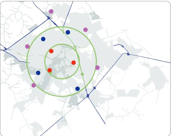
(Figure 1) as follows. The central region (sector 1) has a radius of 2 miles from the center of the city, where there is a predominance of commercial areas, and includes 6 schools. The intermediate or mid-periphery region (sector 2) has a radius of between 2 and 4km from the center, and includes 10 schools. The peripheral region (sector 3) extends outward from a 4-kilometer radius from the city center. Fifteen schools are included in this sector.
The sample size was deined taking into account the estimated population of students (14,057), for the year 2005, provided by the Regional Board of Education, having established 12 schools, selected by drawing lots within each sector, and assessing 1,054 students from the schools in the 3 sectors mentioned.
The students had a mean age of 8.5 years, were mostly male (66%), and were equally affected either unilaterally (47%) or bilaterally (53%).
Figure 1 depicts the digital map of the City of Bauru with concentric circles enclosing the areas in which the schools were chosen by lot. For this, we took into account the number of schools, classes, and students from the region of study, besides representing sectors of the city (center, mid-periphery, and periphery). This subdivision of sections was performed according to a previous study carried out by Lombardi18.
Methodology used in the geoprocessing of trachoma cases
Taking into account the connection of trachoma with conditions related to the environment, living conditions, and socio-economic levels, schools with trachoma cases detected in the survey performed by Ferraz as well as the homes of people with trachoma were geo-referenced.
Geo-referencing was performed employing a global positioning system (GPS) (Personal Navigator©; GARMIN Corporation, Olathe, Kansas), conigured to display latitude and longitude in degrees, minutes, and seconds, with reference to the datum SAD69. These coordinates were then transformed into decimal degrees for analysis in the geographic information systems (GIS) used (TerraView). The spatial analysis was performed with TerraView, using the scores of cases, schools, and Instituto Brasileiro de Geograia e Estatística (IBGE) 2000 census data contained in the CD-ROM Base de informações por setor censitário, Censo demográico 200019, Resultados do Universo. Bauru. IBGE, 2002.
These data were retrieved by Estatcard: Sistema de Recuperação de Informações Georreferenciadas. Version 2.1. IBGE.
The following variables were used: type of housing, water supply conditions, distribution of family income, and educational levels of household heads.
The georeferencing of a given address is deined as the process of association of that address to a map and can be accomplished in 3 basic ways: association with a point, line, or area. The result of this process is the creation of graphics objects that can be used for spatial analysis.
Descriptive spatial analyses and Kernel15 estimates were
RESUlTS
FIGURE 1 - Map of the City of Bauru, State of São Paulo, Brazil, showing the division of the three sectors by green circles, and the 12 randomly selected public schools.
technique that softens the surface by calculating densities for each area, by interpolation, exposing the surface density of events, and facilitating the detection of clusters.
Description of the region under study
The City of Bauru is located in the central region of São Paulo. It is an important development hub for the region. It is one of the cities in the state that brings together the best structures for the establishment of industrial and commercial ventures, with a strong regional trade. The area encompassed by the city is 634km2,
having average elevation of 526meters. Sanitation and water treatment services are present in the greater part of the county. The number of households with a water supply network is 88,854, out of a total of 90,600 houses (98%). There are 86,770 households with a toilet or bathroom connected to the sewage network (95%).
According to the data collected in Census 2000, an analysis of the living conditions of the inhabitants of Bauru shows that heads of households earned an average of R$1,065.00 per month, and 40% earned up to 3 times the minimum wage. These individuals had on average 7.5 years of education, 49.8% of them had completed primary education, and 5.3% were illiterate19.
With regard to demographic indicators, the average age of household heads was 46 years and those under 30 years accounted for 14% of the total. Women household heads accounted for 25.9%, and children under 5 years accounted for 8% of the total population19.
Ethical considerations
This study was reviewed by the Ethics Committee on Human Research (PROTOCOL=29/08) at the Universidade Sagrado Coração de Jesus, Bauru-SP, and approved for implementation on May 25, 2008.
The study by Ferraz20 detected 66 cases of trachoma, all
of them inlammatory. Most of the individuals with trachoma resided in the outskirts of Bauru, and 42% of the cases were detected in the northwest of the city.
Major roules
Very low
Low
Intermediary
High
Very high
Bondaries deparments Rivers and streams
Percent of householders with income up to 3 minimum wages per month 0.0 – 13.68
13.69 – 31.02 31.03 – 48.34 48.35 – 68.66 68.67 – 98.21
Density occurrence of trachoma
1 centimeter equals 0.73Km
FIGURE 2 - Density distribution of the occurrence of trachoma according to family income in the urban area of City of Bauru, State of São Paulo, Brazil.
quantiies the density of cases per unit area, and the background (beige to brown) indicates the percentage of heads of families with up to 3 times the minimum wage income in that census tract. A higher density of occurrence of cases can be observed in areas where there is a greater concentration of low income, which may represent an association between the occurrence of these cases and low income.
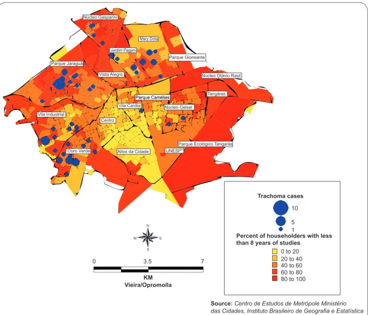
The schooling of household heads is shown in Figure 3, where it is possible to see that a low educational level also suggests an association with trachoma.
DISCUSSION
Epidemiology has been challenged to develop conceptual and methodological frameworks able to apply biological knowledge to social phenomena21. Spatial analysis is a
form of analysis that is applicable to the study of health-disease processes in populations22. Places within a city
or region are the result of the accumulation of historical, environmental, and social situations that may promote conditions for the production of disease. In this sense, one of the important issues for the diagnosis of health situations is the development of indicators that detect and relect conditions of health risk23,24.
The analysis of health conditions corresponds to an aspect of health surveillance that prioritizes the analysis of the health of deined population groups according to their living conditions23.
Income, education, and access to water are not variables related to individuals, but characterize the proile of a population group1.
People live in groups and only group analysis can capture behaviors, values, or even the transmission of infections that occur on this scale25.
The spatial distribution of a disease represents the observed or empirical realization of the underlying generating processes and its study captures the dynamics of the epidemiological structure. The epidemiological proiles of different spaces are created by the interaction of social relations that characterize the organization and are modiied over time, according to the historical moment of the developmental stage of productive forces and social relations, which are the factors that determine the organization of space26.
Núcleo Gasparini
Parque Jaraguá
Vista Alegre
Vila Cardia
Centro
UNESP* Vila Industrial
Ouro Verde
Parque Gionsante
Parque Camélias Parque Camélias
Parque Ecológico Tangarás Núcleo Gelsel
Tangáras Núcleo Otávio Rasil
Altos da Cidade Jardim Pagani
Mary Dota
Percent of householders with less than 8 years of studies
0 to 20 20 to 40 40 to 60 60 to 80 80 to 100
10
Trachoma cases
5 1
Source:Centro de Estudos de Metrópole Ministério das Cidades, Instituto Brasileiro de Geografia e Estatística 0 3.5 7
KM Vieira/Opromolla
*Universidade Estadual Paulista
FIGURE 3 - Distribution of cases of inlammatory trachoma in the City of Bauru, State of São Paulo, Brazil, taking into account the education of the head of the family.
In the case of trachoma, the environment is undoubtedly of paramount importance. Numerous studies have associated the disease with a lack of water and sanitation1,9. However,
presently, in Brazil, most of the urban population has access to water, through the expansion of supply networks, either due to investment by sanitation companies, through individual efforts connecting networks, or even the creation of small unoficial supply networks27. The contamination of surface and ground
water by sewage, garbage, or industrial use may pose a risk to the population served by the supply network. In Bauru, the vast majority of households are connected to the supply network, thereby ensuring the quality of the water supply. Thus, sanitation becomes a complex object that can hardly be represented by a single indicator28.
Considering the large coverage of the municipal sewerage network, this variable would not seem to Influence the occurrence of cases in this study; However, it would be
interesting posteriors more detailed analysis unveils situations That Are Observed When considering not only the overall average coverage of the municipal water supply service, sewage, and solid waste collection, such as discontinuation of water supply and waste collection daily.
The methodology used herein simpliies the search for the disease, since it allows the detection of affected children much more easily than a search performed based on the detection of cases on a sample of households. However, assuming that not all children attend school, with those in this situation possibly having the lowest income level, the assessment based on schoolchildren may not be the most reliable method. In spite of this consideration, this is the method most used for this purpose when it comes to the study of trachoma.
and economic conditions, which are more prone to the maintenance of communicable diseases. A similar method was used in Sudan, making it possible to establish risk areas linked to the transmission of trachoma, and to establish detection and treatment plans1.
Trachoma is still a public health problem in Bauru. The cases detected show that there are micro-scale regions where sanitation is still unsatisfactory and efforts should be undertaken to improve it.
We propose that detected trachoma cases be an indicator of priority regions for health action, leading to greater optimization of resources in these areas.
The methodology used in this study has a great potential for disease surveillance in cities with low infestation. Through GIS techniques can more precisely identify areas of risk, provided there is a constantly updating database of cases reported as suspected. For the proposed methodology has maximum eficiency in the detection of areas of risk of transmission, you must fill in the appropriate addresses s databases. In municipalities that have no basis for parks to address location, the GPS could be adopted to the geographical location of outbreaks and cases. Thus, you can take immediate preventive measures (removal of focus) in the area of inluence of cases
The authors declare that there is no conlict of interest. CONFlICT OF INTEREST
REFERENCES
1. Clements ACA, Kur LW, Gastan G, Ngondi JM, Emerson PM, Lado M, et al. Trageting trachoma control through risc mapping: the example of Southern Sudan. PLoS Negl Trop Dis 2010; 4:e799-811.
2. Burton MJ, Mabet DCW. The global burden of trachoma: a review. PLoS Negl Trop Dis 2009; 3:e460-466.
3. Bamani S, King JD, Dembele M, Coulibaley F, Sankara D, Kamissov V, et al. Where do we go from here? Prevalence of trachoma 3 years after stopping mass distribution of antibiotics in the regions of Kayes and Koulikoco, mal. PLoS Negl Trop Dis 2010; 4:e734-746.
4. Barros OM, Luna EA, Medina NH, Gentil RM. Manual de controle do tracoma. Brasília: Ministério da Saúde, Fundação Nacional de Saúde; 2001.
5. Assaad FA, Masxwell-Lyons F, Sundaresan T. Use of local variations in trachoma endemicity in depicting interplay between socio-economic conditions and disease. Bull World Health Organ 1969; 41:181-194.
6. Shneider MC, Aguilera XP, Silva-Junior JB, Ault SK, Najra P, Martinez J, et al. Elimination of neglected diseases in Latin America and the Caribbean - a mapping of selected diseases. PLOS Trop Dis 2011; 5:e964-77.
7. Ministério da Saúde. Guia de vigilância epidemiológica. 7th ed. Série A. Normas
e Manuais Técnicos. Brasília: Ministério da Saúde; 2009.
[Campinas]: Faculdade de Ciências Médicas, Universidade Estadual de Campinas; 1993. 152 p.
9. Hägi M, Schemann JK, Mauny F, Momo G, Sacko D, Traoré L, et al. Active trachoma among children in Mali. PLoS Negl Trop Dis 2010; 4:e583-580. 10. Toledo AS. Estatística e distribuição do tracoma no Estado de São Paulo.
Arq Bras Oftalmol 1939; 2:53-64.
11. Bennett D. Explanation in medical geography. Evidence and epistemology. Social Science Medicine 1991; 33:339-346.
12. Barcellos C, Santos SM. Colocando dados no mapa: a escolha da unidade espacial de agregação e integração de bases de dados em saúde e ambiente através do geoprocessamento. Inf Epidemiol SUS 1997; 6:21-29.
13. Malta DC, Almeida MCM, Dias MAS, Merhy EE. A mortalidade infantil em Belo Horizonte, Minas Gerais, Brasil, por área de abrangência dos Centros de Saúde (1994-1996). Cad Saude Publica 2001; 17:1189-1198.
14. Vine MF, Degnan D, Hanchette C. Geographic Information Systems: their use in environmental epidemiologic research. Environ Health Perspectives 1997; 105:598-605.
15. Bailey TC. A review of statistical spatial analysis ingeographical information systems. In: Fotheringham S, Rogerson P, editors. Spatial Analysis and GIS. Londres: Taylor & Francis; 1994. p. 13-44.
16. Câmara G, Monteiro AMV. Geocomputation techniques for spatial analysis: are they relevant to health data? Cad Saude Publica 2001; 17:1059-1081. 17. Ferraz LCB. Tracoma em crianças do ensino fundamental no Município de
Bauru - Estado de São Paulo, Brasil [Thesis]. [Botucatu]: Faculdade de Medicina, Universidade Estadual Paulista; 2006. 162 p.
18. Lombardi HF. Oportunidades de diagnóstico precoce do HIV em gestantes do município de Bauru [Dissertation]. [Botucatu]: Faculdade de Medicina, Universidade Estadual Paulista; 2002. 102 p.
19. Fundação Instituto Brasileiro de Geograia e Estatística (FIBGE). Censo Demográico 2000 - Resultado do universo relativo às características da população e dos domicílios, Rio de Janeiro: FIBGE; 2000.
20. Ferraz LCB, Schellini SAAS, Padovani CR, Medina NH, Dalben I. Tracoma em crianças do ensino fundamental no município de Bauru: Estado de São Paulo, Brasil. Arq Bras Oftalmol 2010; 73:433-437.
21. Possas C. Padrões epidemiológicos: uma propostaconceitual. In: Possas C, editor. Epidemiologia e Sociedade: Heterogeneidade Estrutural e Saúde no Brasil. São Paulo: Editora Hucitec; 1989. p. 179-234,
22. Costa MCN, Teixeira MGLC. A concepção de “espaço” na investigação epidemiológica. Cad Saude Pública 1999; 15:271-279.
23. Barcellos CC, Sabroza PC, Peiter P, Rojas L. Organização Espacial, Saúde e Qualidade de Vida:Análise Espacial e Uso de Indicadores na Avaliação de Situações de Saúde. IESUS 2002; 11:129-138.
24. Medina NH, Lopes MF, Durkin SR, Cardoso MR, Luna EA, Koizumi IK, et al. Survey of Trachoma within school students in the state of Roraima, Brazil. Ophthalmology 2011; 118:1938-1943.
25. Carvalho MS. Aplicação de métodos de análise espacial na caracterização de áreas de risco à saúde [Thesis]. [Rio de Janeiro]: Universidade Federal do Rio de Janeiro; 1997. 162 p.
26. Breilh J. Epidemiologia: Economia, Política e Saúde. São Paulo: Editora da UNESP/Co-edição: Hucitec; 1991.
27. Pontes CAA, Schramm FR. Bioética da proteção e papel do Estado: problemas morais no acesso desigual à água potável. Cad Saude Publica 2004; 20: 1319-1327.