Religion, Kulte und Rituale in der mittelalterlichen bäuerlichen Umgebung
Réligion, cultes et rituels au milieu rural médiéval
RELIGION,
CULTS & RITUALS
IN THE MEDIEVAL RURAL ENVIRONMENT
edited by
CHRISTIANE BIS-WORCH & CLAUDIA THEUNE
Source reference:
This is a free offprint – as with all our publications
the entire book is freely accessible on our
website, where you can also buy a printed copy
or pdf E-book.
W W W.SIDESTONE.COM
© 2017 Individual authors
The authors are responsible for the content of the papers (incl. image credits).
Published by Sidestone Press, Leiden www.sidestone.com
Imprint: Sidestone Press Academics
Lay-out & cover design: Sidestone Press
Photograph cover: Saint Marys oak-tree of Altrier-Hersberg (© CNRA, Centre National de Recherches Archéologiques, Grand-Duché de Luxembourg)
Contents
Foreword 9 Claudia Theune
Introduction to the conference papers 11
Christiane Bis-Worch
Past and present meet: contemporary expressions of faith along 13
the Camino Frances.Observations by a modern pilgrim Bert Groenewoudt
Courtyard sites and their cultic context 25
Frode Iversen
Anomaly or myth? Sami circular offering sites in medieval 39
northern Norway Marte Spangen
Livs’ offering cave (Latvia): new discoveries 53
Juris Urtāns
Les gravures de « la Table des Bergers » 61
Frédéric Surmely
Struell: bathing at midsummer and the origins of holy wells 69
Finbar McCormick
Medieval hermit caves and rock-cut hermitages in Great Britain 79
James Bond
Klostergründungen – In mystischen Wäldern oder an 91
urbaren Feldern? Miriam Steinborn
Privately founded Benedictine Monasteries in medieval Hungary 103
– a case study: Pétermonostora, the monastery and a settlement without written history
Edit Sárosi & Szabolcs Rosta
The Byzantine settlement of Shivta in the Negev Desert and its 115
churches: An analysis of their spatial arrangement within the settlement and its social implications
Constanze Röhl
Réflexions topologiques sur les églises antérieures à 1050 dans 129 l’ancien diocèse de Tongres-Maastricht-Liège
Le site de Sainte-Catherine-de-Fierbois (Indre-et-Loire, France) : 141 un nouvel exemple d’édifice religieux/funéraire alto-médiéval en
contexte d’habitat rural Cyrille Ben Kaddour
Le phénomène de pierres antiques incorporées dans des 153
édifices chrétiens au Grand-Duché de Luxembourg – état de
recherche et nouvelles questions Estelle Michels
Rural mosques and settlements: some reflections from the 165
archaeology of al-Andalus (11th-13th centuries) Jorge A. Eiroa
Landjudentum im nordbayerischen Franken. Geschichte und 175
Archäologie Hans-Peter Süss
Priest houses in rural settlements of medieval Hungary 189
Tibor Ákos Rácz
Sépultures des marges et sépultures marginales : sur quelques 201
exemples médiévaux de la moitié sud de la France Yves Gleize
Rock-cut graves and cemeteries in the medieval rural landscape 215
of the Viseu region (Central Portugal) Catarina Tente
A place for the ancestors: early medieval burial sites in the 227
central area of the Iberian Peninsula Iñaki Martín Viso
Mortuary archaeology and variation in death culture in eastern 241
North-Brabant (The Netherlands), c. 900-1900 AD Nico Arts
The identity of the community and the identity of the individual: 253
the burial of the deceased within the settlement in the Middle Ages in Northern Croatia
Siniša Krznar & Tatjana Tkalčec
A village is cleared – the pilgrimage with stillborns to the 263 Holy Shrine of the Virgin Mary in Oberbüren (Canton of Berne,
Switzerland)
Daniel Gutscher
Deviant burials in rural environment in the High Middle Ages – 271
ritual, the lack of ritual, or just another kind of it? Mária Vargha
Der würdige und der unwürdige Tod im schlesischen Dorf 281 des 13. bis 18. Jahrhunderts
The investigation of traces of religious cults and practices in the 291 medieval rural archaeology of Hungary
Miklós Takács
Lay devotion in rural and urban contexts in medieval Sweden 303
Elisabet Regner
Brabantian fields, blessed land – a study about the origins of 315
artefacts found in arable land Johan Verspay
Building sacrifices and magical protection: a study in canton of 325 Grisons (CH)
Iris Nießen
Votive offerings in buildings from rural settlements – folk beliefs 337
with deeper roots Morten Søvsø
Archéologie des pratiques apotropaïques entre Lorraine 347
et Luxembourg Jean-Marie Blaising
Zauberbohrungen, magische Zeichen und „Hexenbriefe“ – 357 Spuren von Alltagsmagie in Bauernhäusern aus
Nordwestdeutschland Heinrich Stiewe
Magical dwelling: apotropaic building practices in the New World 373 Dutch Cultural Hearth
215
Rock-cut graves and cemeteries
in the medieval rural landscape
of the Viseu region (Central
Portugal)
Catarina Tente *
ABSTRACT
Viseu and its territory are located in central-northern Portugal, between the Douro and the Mondego rivers. This was a frontier territory between Christians and Muslims from the 8th to the 11th centuries. A large number of rock-cut tombs are known in the area. These sites, which are devoid of grave goods, are generally organized in small scattered groups (one to ten tombs) and are seldom clustered in large cemeteries. As far as the available evidence shows, the majority lack any close relationship with religious buildings, whereas some are known to be located in proximity to habitation places. Available data on these religious and socio-economic phenomena indicate we are dealing with segmentary societies in which family and kinship relations played a structuring role in the funerary landscape of the region.
Keywords: Early medieval territories, local communities, rural churches, Christian Conquest Period.
RÉSUMÉ
Tombes taillées dans la roche et les cimetières dans le paysage rural médiéval de la région de Viseu (centre du Portugal)
Viseu et son territoire se situent au Portugal centre-nord, entre les rivières Douro et Mondego. Cette région fut une terre de frontière entre chrétiens et musulmans du VIIIe au XIIe siècle. Un grand nombre de tombes rupestres sont connues dans la
région. Ces sites, dépourvus de mobilier funéraire, sont organisés en petits groupes dispersés (1 à 10 tombes). Plus rarement, les tombes sont regroupées dans de grands cimetières. L’information disponible montre que la majorité de celles-ci ne présente pas de relation étroite avec les édifices religieux, dont certains se sont implantés à proximité des lieux d‘habitation. Les données actuelles sur ces phénomènes religieux
*Instituto de Estudos Medievais – FCSH, Universidade Nova de Lisboa, Portugal catarina.tente@gmail.com
216 religion, cults & rituals in the medieval rural environment
et socio-économiques indiquent que nous sommes face à des sociétés segmentaires, dans lesquelles les relations familiales et les liens de parenté prirent un rôle structurant dans le paysage funéraire de la région.
Mots-clés : territoires médiévaux, communautés locales, églises rurales, période de la conquête chrétienne.
ZUSAMMENFASSUNG
In Fels gehauene Gräber und Friedhöfe in der
mittelalterlichen ländlichen Landschaft der Region Viseu (Zentral Portugal)
Viseu und sein Umland zwischen dem Douro und den Mondego Fluss liegen im zentral-nördlichen Portugal. Die hier behandelte Region stellte im 8. bis 11. Jahrhundert ein Grenzgebiet zwischen Christen
und Muslimen dar. In dem Gebiet sind zahlreiche Felsengräbern bekannt, die keine Grabbeigaben enthalten. Sie sind oft in kleinen verstreuten Gruppen von 1 bis 10 Gräbern organisiert, seltener in Form großer Friedhöfe. Bisher konnten keine engeren räumlichen Beziehungen zu religiösen Gebäuden belegt werden, jedoch liegen einige in der Nähe von Wohnplätzen. Die bisher verfügbaren Daten zu diesem religiösen und sozioökonomischen Phänomen weisen in Richtung segmentärer Gesellschaften, in denen die Familien- und Verwandtschaftsbeziehungen die strukturierende Rolle in der Grab-Landschaft der Region spielen.
Schlagwörter: Frühmittelalterliche Territorien, Landgemeinden, Landkirchen, Periode der Christlichen Landnahme.
Introduction
Rock-cut graves are known in several western European countries, but they are a particularly common phenomenon in the Iberian Peninsula, where this type of funerary structure and its associated practices were a long-lasting tradition, in use from the 6th to the 12th centuries AD. In many parts of Iberia rock-cut graves are the most abundant funerary remains left by early medieval communities. They are particularly common in central Portugal, where they are the most outstanding medieval testimony in the region’s rural landscape. This is clearly related to the fact that they were carved in a durable material and therefore remain highly visible in the archaeological record. However, they are far from being evenly distributed in the territory (see below).
At the same time, rock-cut graves are enigmatic archaeological monuments that present a number of difficulties for interpretation. This is due to the lack of their original contents: grave goods, human remains or even their infill. Despite being extremely difficult to analyse and study, their distribution and spatial relationship with habitation sites allows us to approach the creation of the rural landscape in the region. These necropolises are also testimonies to a deliberate intention of marking the landscape in various ways, from long-lasting places for the dead to the economic, social and symbolic appropriation of a rural territory in Early Medieval times. The durability and location of graves was clearly intentional. Rock-cut graves were in many ways the most permanent human-made monuments in this landscape, and it seems likely that they were a focus for remembrance, expressing a connection to ancestors, and perhaps a way of legitimizing control over land by
specific kin groups (Martín-Viso 2012a; 2014, see also Martín-Viso in this volume).
The present study focusses on the Viseu territory in central Portugal between the 6th and the 12th centuries, the time when rock-cut tombs are thought to have been used. A total of 522 sites have been recorded in 26 modern municipalities, covering a total of 6150 km2. This inventory is, however, only a first approach
217 tente
1. The Viseu region
Viseu and its territory are located in the highlands of central-northern Portugal, between the Douro and the Mondego river basins (Fig. 1).These highlands are bordered by a series of mountains, of which Estrela Mountain to the east is the highest summit, at 1,993 m asl. To the north, the territory is delimited by the left banks of the Douro River and its surrounding hills. It is also separated from the coastal plain to the west by a chain of mountains. Within these vast plateaux, the city of Viseu is remarkable for its centrality and two important river basins–the Mondego, the Vouga and their tributaries–that drain to the Atlantic, by the south-west and the west respectively.
In Roman times, Viseu was capital of a civitas, centralizing the road system that connected the northern, southern and inland sectors of Iberia with the nearest Atlantic coast. After the fall of Rome, Viseu became an episcopal centre, as documented at least from the 6th century. Its limits are not well known; however, we can tentatively propose this map as a reliable proposal, based on the available written records. By the middle of the 7th century, Viseu lost part of its territory in favour of a then newly-founded diocese, Caliábria, located between the
Côa and Douro rivers, in the region’s north-east sector. From the 8th to the 11th centuries, these territories were a frontier land between Christians and Muslims.
In geological terms, the region is characterized mainly by granites and schist, covered by relatively thin and acidic soils that compromise the preservation of organic remains. Due to human-induced deforestation since Neolithic times and to subsequent erosion, the most fertile soils can be found today mostly in lower lands and river valleys.
2. Rock-cut graves and cemeteries
In the Viseu region, 522 sites are currently known with rock-cut tombs, which constitute the basis for this study. The minimum number of graves has been calculated as 1,726. These sites display variable patterns of geomorphologic location and grave typology. Moreover, the intra-site arrangement of the graves differs greatly from site to site. What these structures have in common is their apparently deliberate purpose of being a long-lasting funerary monument, marking this medieval rural space.
Most cemeteries consist of fewer than 10 graves, normally dispersed. Few sites have a larger number of
218 religion, cults & rituals in the medieval rural environment
graves. Since A. del Castillo’s seminal works (Castillo 1970; 1972), rock-cut graves have been analysed in terms of typology and sites classed according to their number of graves (isolated or in small groups). For this author, rock-cut graves were a funerary phenomenon spread by Christians who came from the south to the centre and north of Iberia to populate these areas. This model–and especially its chrono-typological features–was criticized by several authors who considered its proposed evolution from simple to complex types was unsupported, and that both coexisted at some point in time and space, namely when pairs were found placed side-by-side as indicating kinship relations (e.g. Reys – Menéndez 1985; Barroca 1987; Tente – Lourenço 1998; Tente 2007). They also contested the idea of a close relationship between this kind of funerary manifestation and the repopulation of the area (Bolós – Pagés 1982; Barroca 1987; Vieira 2004;
Lourenço 2007; Martín-Viso 2007; 2009; 2011; Tente 2009; 2010; Padilla – Álvaro 2010, 2012). Recently Martín-Viso (2012a) has put forward a new classification of these sites in three main categories: isolated graves, ordered cemeteries, and disordered cemeteries. The advantage of this model is that it attempts a correlation between the arrangement of the graves and the social organization of their builders. It also predicts that the graves’ location may reveal their role as landmarks (Martín- Viso 2012b; 2014; Tente 2015).
This paper applies an adapted version of Martín-Viso’s classificatory model (Martín-Viso, 2012a; see also Martín-Viso in this volume, whose paper is framed under the same theoretical perspective), because it is considered important to separate isolated graves from the scattered groups, which are in the same category in his model. There are some sites with a single grave that are interpreted differently regarding the social organization and memory of the peasant communities, such as the example of Penedo dos Mouros (municipality of Gouveia), which will be discussed below. Consequently, for this paper the sites have been classified in four different types: isolated graves (a single grave); scattered groups of 2 to 10 graves (small necropolises consisting of scattered graves); disordered cemeteries (with more than 10 graves apparently disposed in a non-patterned way); ordered cemeteries (with more than 10 graves where there is apparently an intentional spatial arrangement).
In the Viseu territory, this kind of funerary manifestation is dominated by isolated graves and scattered groups of 2 to 10 graves. Around 93% of the known sites are organized this way. Larger cemeteries are more scarce. The few clustered graves are not confined to a well-delimited area and are randomly scattered, at least apparently, or follow a norm or logic we find today difficult to understand (Fig. 1). Each of the categories will be described in more detail.
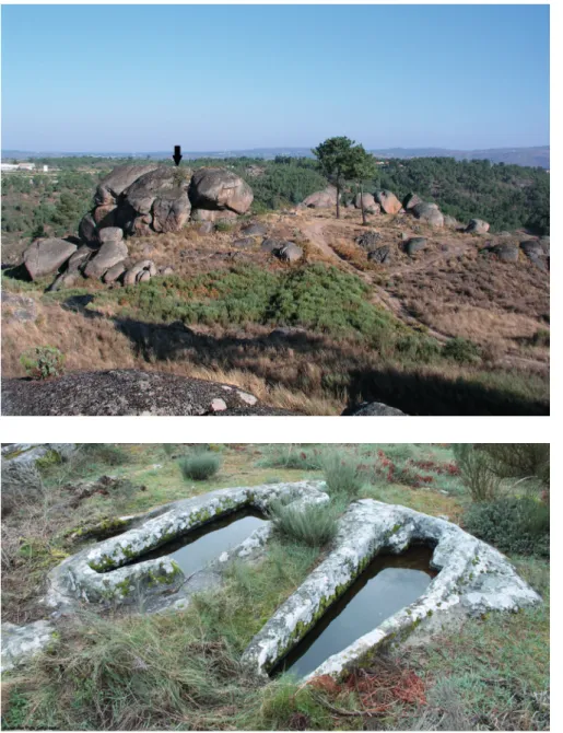
Isolated graves represent 37.7 % of the total inventory of sites. This category includes 197 graves of various types (Tab. 1). Most are of adult size but in three cases these seem to have been intended for children. In terms of geographic location, isolated graves are found either in valley bottoms, mid-slopes, near water bodies, swamps or even on mountain plateaux, above 1,000m asl. Thus, it is not possible to recognize a dominant pattern (Fig. 1). Similarly, no recognizable pattern can be identified in their orientations. Many would have been in the vicinity of workplaces or near habitation sites of small family-groups.
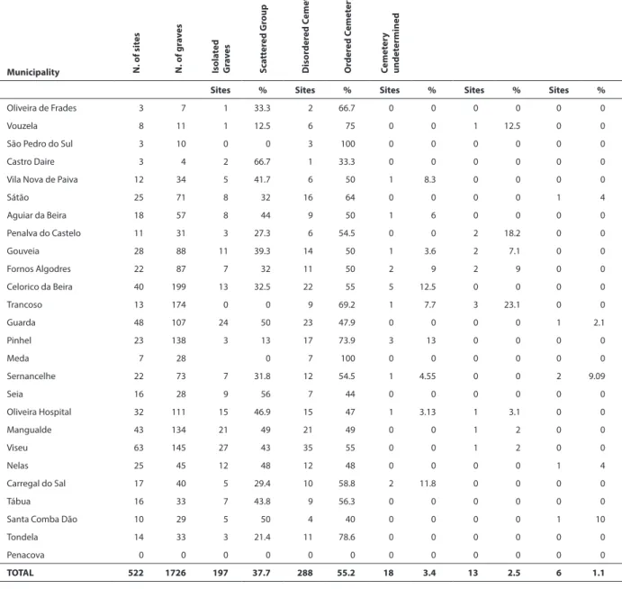
There is, however, one case that suggests other interpretations. The site of Penedo dos Mouros was excavated archaeologicallyin 1998, 2008 and 2009. This work revealed a fortified settlement located on a platform overlooking the fertile Boco stream valley (Fig. 2). A few huge granite boulders on its eastern side supported a complex wooden superstructure. The valley must have been exploited by the human group established in the site, since hundreds of burnt broad beans, among other botanic remains, were recovered during the excavations. The site was abandoned after a fire that took place sometime in the second half of the 10th century, leading to its destruction and the collapse of the wooden structures (Tente 2010;
2015; Tente –Carvalho 2011). Penedo dos Mouros possess only one rock-cut grave, on top of the highest granite boulder. It is not possible to claim that the 10th- century habitation structures were coeval with the tomb, but its location and direct access by rock-cut steps is very suggestive of some kind of relationship between the two. The most likely explanation is that the grave was cut after the destruction and abandonment of the fortified site, which occurred in the second half of 10th century. If so, we are forced to consider that whoever built and used the tomb lived in a time when the memory of the site, and possibly of the event that caused its destruction, was still in the oral tradition. In this hypothesis, this tomb would have been, above all, a place of remembrance.
Scattered groups of two to ten graves are the most common type of cemetery, representing 55.2% of the inventory of sites (Tab. 1). Altogether, this category includes a minimum number of 987 tombs of diverse types. These cemeteries are dispersed across the whole territory (Fig. 1). Scattered groups are clusters of graves rather than necropolises, if these are understood as community cemeteries. These sites are not organized; quite the contrary, they are found scattered across the landscape in no apparent pattern. At their intra-scale of analysis, the graves also display what seems to be a chaotic dispersal.
219 tente
quadrants; here, the deceased were buried facing each other, as in the case of the Tapada da Serra graves, located on Estrela Mountain (Tente 2007, 73). It is also common to find two adult graves in association or one adult and one juvenile or infant. The available data indicate a minimum number of 35 child graves within this category. Everything seems to point to a kinship relation in these cases. Although normally one child grave is found per site, there are a large number of sites without any, and in one case the three graves recognized seem to have been for children (Três Rios, in Tondela municipality).
The disordered necropolises aggregate more than 10 graves. These represent only 3.4% of the analysed sites,
representing a total of 280 graves (Tab. 1). However, the majority of these necropolises revealed a small number of graves–indeed, nine of them have fewer than 20 graves and a further three cases do not exceed 31 graves. The outstanding exception is São Gens, in the municipality of Celorico da Beira, where there are more than 54 graves.
The highest density of cemeteries is found around the foothills of Estrela Mountain or, in other words, away from the urban and diocesan centre of Viseu and lordships.
These cemeteries are arranged in a dispersed pattern very similar to that of the scattered groups. Direct associations between graves are also very common. As
Municipality N. of sit
es
N. of gr
a v es Isola ted G ra ve s S ca tt er ed G roup D isor der ed C emet er y O rder ed C emet er y C emet er y undet ermined
Sites % Sites % Sites % Sites % Sites %
Oliveira de Frades 3 7 1 33.3 2 66.7 0 0 0 0 0 0
Vouzela 8 11 1 12.5 6 75 0 0 1 12.5 0 0
São Pedro do Sul 3 10 0 0 3 100 0 0 0 0 0 0 Castro Daire 3 4 2 66.7 1 33.3 0 0 0 0 0 0 Vila Nova de Paiva 12 34 5 41.7 6 50 1 8.3 0 0 0 0
Sátão 25 71 8 32 16 64 0 0 0 0 1 4
Aguiar da Beira 18 57 8 44 9 50 1 6 0 0 0 0 Penalva do Castelo 11 31 3 27.3 6 54.5 0 0 2 18.2 0 0 Gouveia 28 88 11 39.3 14 50 1 3.6 2 7.1 0 0 Fornos Algodres 22 87 7 32 11 50 2 9 2 9 0 0 Celorico da Beira 40 199 13 32.5 22 55 5 12.5 0 0 0 0 Trancoso 13 174 0 0 9 69.2 1 7.7 3 23.1 0 0 Guarda 48 107 24 50 23 47.9 0 0 0 0 1 2.1
Pinhel 23 138 3 13 17 73.9 3 13 0 0 0 0
Meda 7 28 0 7 100 0 0 0 0 0 0
Sernancelhe 22 73 7 31.8 12 54.5 1 4.55 0 0 2 9.09
Seia 16 28 9 56 7 44 0 0 0 0 0 0
Oliveira Hospital 32 111 15 46.9 15 47 1 3.13 1 3.1 0 0
Mangualde 43 134 21 49 21 49 0 0 1 2 0 0
Viseu 63 145 27 43 35 55 0 0 1 2 0 0
Nelas 25 45 12 48 12 48 0 0 0 0 1 4
Carregal do Sal 17 40 5 29.4 10 58.8 2 11.8 0 0 0 0
Tábua 16 33 7 43.8 9 56.3 0 0 0 0 0 0
Santa Comba Dão 10 29 5 50 4 40 0 0 0 0 1 10
Tondela 14 33 3 21.4 11 78.6 0 0 0 0 0 0
Penacova 0 0 0 0 0 0 0 0 0 0 0 0
TOTAL 522 1726 197 37.7 288 55.2 18 3.4 13 2.5 6 1.1
220 religion, cults & rituals in the medieval rural environment
in scattered groups, it is possible that we are dealing in these cases with kinship relations.
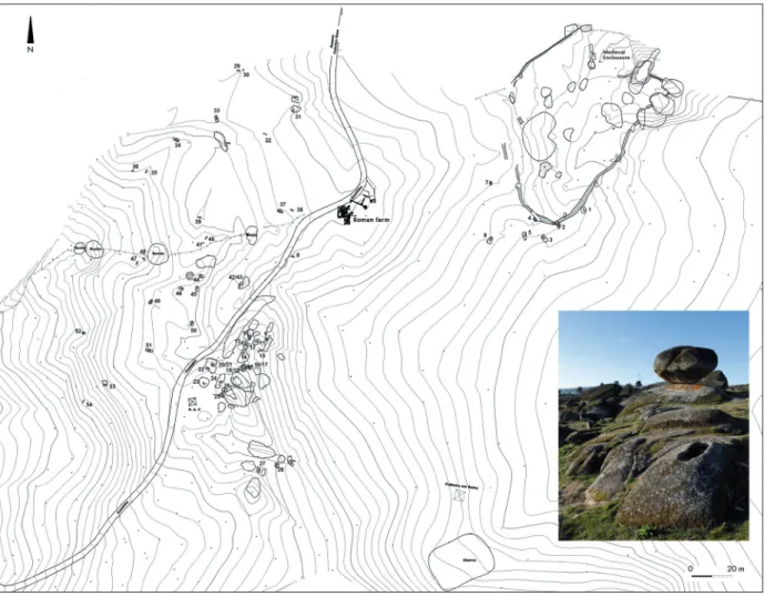
One site stands out from the others. São Gens (Fig. 3) covers all these characteristics, but also displays a further notable aspect: this is the largest of all rural necropolises known in the region. São Gens is an archaeological complex with a disordered cemetery. Overall, these graves are scattered across a large area and no internal organization is evident. This necropolis, with 56 graves, was built around a Roman farm that was abandoned by the end of the 4th century. The number of graves may originally have been slightly higher, since we know from oral traditions that some graves were destroyed. São Gens is almost imperceptible in the landscape, revealing a very limited visual control over the horizon.
The medieval settlement had a walled perimeter, oval in shape, enclosing an area of around 0.5 ha. This site was under excavation between 2008 and 2012. From the datable material culture and radiocarbon dates, it is clear that occupation of the settlement was restricted largely to the 10th century. The enclosure contains within it a large number of granite boulders and evidence of hut structures. It is likely that the structures were constructed entirely in perishable organic materials, the remains of which only survive in cases of fire-induced preservation Two radiocarbon determinations were obtained (short-lived samples such as cork and bushes) to date a great fire that occurred around the second half of the 10th century. This was responsible for the complete destruction and abandonment of the site (Tente – Carvalho 2011). The
Fig. 2. Penedo dos Mouros (municipality of Gouveia). The 10th – century site has a single grave cut in the major boulder that supported a complex wooden superstructure. The rock-cut grave is signed by the arrow (© Catarina Tente).
221 tente
archaeological excavation revealed that occupation was concentrated within the enclosure.
Although the occupied area was concentrated, the cemetery was not: the graves are scattered across an area of 6 ha. Some graves are relatively isolated; others are grouped into small clusters, just as in the category of scattered groups. Within the small groups, graves show some sign of patterning, however the level of dispersion and the general layout of the graves suggest that there was no formal organisation of the funerary space. Great diversity is seen in terms of both grave types and orientations, in spite of a slight tendency of them to point to the east, north-east and south-east. Based on their dimensions, six of the 54 graves (11%) would appear to belong to children; ranging from 64 cm to 125 cm in length. In addition, there are six unfinished graves, two of which are child sized (Brookes et al. forthcoming).
Both the spatial analysis of the cemetery layout and the archaeological data from the enclosure suggest that the site was used by a community comprising
three or four self-identifying groups, over a period of around four generations. The general lack of spatial differentiation within the cemetery may suggest these were the graves of relatively equally-ranked members of the community, albeit reflecting a household organization (Brookes et al. forthcoming).
Ordered cemeteries represent a very small percentage, totalling only 2.5% of all known sites. When located near modern churches, it is often difficult to determine the total number of rock-cut graves; indeed, only excavations would allow these to be counted (and individualized from other types of graves), but usually only part of the total cemetery area is studied.
Their main characteristic is the clustering of a very high number of graves in a reduced space, usually cut side-by-side and following a dominant orientation. In the majority of the cases, these necropolises were built in close association with churches, such as São Pedro da Lourosa, one of the few 10th – century churches known in the region (Fig. 5). Its construction has been
222 religion, cults & rituals in the medieval rural environment
attributed to an important elite established in Viseu (Fernandes 2005; Real 2014).
Ordered cemeteries increase in number in the second half of 12th century and mainly during the following. In Portugal, the parochial system emerged first in towns, and spread later and more slowly in rural areas. It must have been in the wake of the Gregorian reform, along with the later implementation of the tithe, that parish churches would start to be systematically built and have their jurisdiction legally defined (Mattoso 1985, 401-405). This was a time when the parishes were being established in the region. This phenomenon implied the building of churches that aggregated the parish interments. This changing funerary behaviour had as a consequence the progressive abandonment of the scattered-type groups of graves and disordered cemeteries. In these parishes, rock-cut graves
are found alongside other forms of inhumation. Graves are often found overlying each other, and several events of disturbance of the older ones are frequently identified. This may reflect depersonalization of at least some of the graves. Here, identity and ancestry do not seem to be as important as before. These notions are replaced by the feeling of belonging to a broader community that shares, above all, a common faith and church. This phenomenon irreversibly changed the inhumation practices but reflects, above all, the existence of an external and supra-local power that regulated and organized the religious and social lives of the communities.
From the few preserved bone remains so far exhumed from rock-cut graves (because of the acidity of granitic and schist substrata), only two radiocarbon determinations were obtained in this area (see also
Fig. 5. Distribution map (© Catarina Tente and Tomas Cordero Ruiz) of sites with rock-cut graves, and location of churches that are mentioned for the first time before 1101, and architectonic and archaeological remains of churches before the 12th century (Rodrigues 1999).
Churches: São Pedro [do Sul] (1085), Santa Maria de Vouzela (1070), São Vicente de Lafões (1092), Santa Maria do Arcozelo (1083), São
Tiago do Mato (1083), Monastery of Vouzela (1082), Santa Maria da Várzea (1070), São Gens de Nespereira (1078), São Miguel Fetal (880?), Santa Eugénia (1099), São Martinho (1066); Monastery of Seperandei (957), Monastery of Fráguas (1129), Monastery of Currelos (981), Molelos (1101), and Treixedo (981).
Architecture and archaeological remains of churches: São Martinho (c. 10th), Figueiredo das Donas (c. 10/11th), Monastery of Fráguas
223 tente
Martín-Viso, this volume): one from an isolated grave (Alto da Quintinha), and the other from the first phase of occupation of one of the parish cemeteries (Algodres). The results are very interesting in spite of the skewed available radiocarbon evidence (Tab. 2). Indeed, they suggest that the necropolises scattered throughout the landscape are a much older phenomenon, whereas cemeteries aggregated to parish churches occur mostly after the end of 12th century.
In the older phase, the ‘architectonic’ option was to cut the graves in granitic outcrops, but through time and with the increasing number of burials in restricted spaces, an option for simpler and faster solutions becomes more common, such as inhumations in earth graves and the use of stone slabs.
3. Discussion
Despite the large number of sites in the territory of Viseu, only a few have been studied archaeologically. Available data show diversified realities, as is the case of the two sites discussed in this chapter: Penedo dos Mouros and São Gens. Given the state of research, a larger set of sites needs to be studied. However, it should be noted that this will not change a well-established scattered pattern across the region’s rural landscape during the 6th – 12th centuries. In the Viseu region, rock-cut graves cluster generally in small dispersed groups and often seem to be connected with living/working areas rather than with religious structures. Indeed, the distribution map of these sites shows an image of fragmented space, thus suggesting a segmented social reality in which the household is its main structuring feature. This is in perfect accord with the lack of written documents mentioning churches before the 12th century. Churches are also very scarce in the rural archaeological record (Fig. 5), and were probably correspondingly rare in the landscape.
Therefore, churches must have been very few in number and were, in most cases, away from the populations. The distribution of graves in the territory reflected the presence of household and local groups only, thus testifying a segmentary type of social organization. Ancestors served not only to mark the space but also to legitimate control over a certain terrain by their descendants (Martín-Viso 2014).
In this regard, it is interesting to note that more labour was applied in cutting the outcrops, where long-lasting graves could be dug, than at habitation sites, which were built with perishable materials. The durability and location of the graves was, therefore, intentional and can only be related, in the Early Middle Ages, with the exploitation of agricultural land and forests.
It should be mentioned that, according to what can be inferred from written sources, the location of churches and monasteries does not overlap with the distribution of rock-cut graves. The largest concentration of religious buildings before the 12th century was in the city of Viseu and its immediate surroundings, where they were probably founded by the Diocese. A similar trend can also be observed to the north-west of Viseu. In this part of the region (the Lafões area), a larger number of written documents (Rodrigues 1999) attests to the presence of counts and their courts from the 9th century onwards, who would have been responsible directly or indirectly for the foundation of several churches and monasteries.
In rural spaces located in more remote areas, or away from the areas of interest of the dominating powers, churches were scarce and populations had more liberty to choose where to create their scattered necropolises. Conversely, in Lafões, the presence of so many churches and monasteries in a rural area seems to have implied a more restrictive control over family or community funerary practices by the ruling social groups.
This phenomenon will eventually become common in the whole region after the end of 12th century, a moment in time when the Church definitively disrupts the household and community logic that was being expressed, until then, in the funerary manifestations of the Early Middle Ages.
Acknowledgements
I am grateful to Iñaki Martin-Viso, who is responsible for my return to the analyses of rock-cut graves, and the principal researcher of the project ‘Colapso y regeneración en la Antigüedad Tardía y la Alta Edad Media: el caso del Noroeste peninsular’ (HAR2013-47789-C3-1-P), funded by the Spanish Ministerio de Ciencia e Innovación. It was within this project that part of this work was developed. The other project that supported some research was ‘Desigualdad social en los paisajes medievales del norte peninsular: los marcadores arqueológicos’ (HUM2012-32514), directed by Juan Antonio Quirós Castillo. I also thank Professor José Mattoso, Sara Prata, Sofia Pereira, Stuart Brookes, Paulo Almeida Fernandes and Manuel Real, for the sharing of information and scientific discussion, and Tomas Cordero for the making of the maps that illustrate this paper.
Provenance Lab Number Date BP cal BC/AD
Alto da Quintinha Sac-2333 1080 ± 50 778-791 (1,4%), 805-842 (2,7%), 861-1032 (91,2%). Algodres (grave nº23) Sac-2207 710 ± 40 1356-1389 (17,7%),
1224-1315 (77,7%).
224 religion, cults & rituals in the medieval rural environment
References
Edited documents:
Rodrigues, M. A.(ed.) 1999:
Livro Preto. Cartulário da Sé de Coimbra. Coimbra. Universidade de Coimbra.
Bibliography
Álvaro Rueda, K. – Padilla Lapuente, J.I. 2012:
Arquitectura religiosa y necrópolis rupestres entre el alto Arlanza y la cabecera del Duero (ss. IX-XI), Hortus Artium Medievalium 18:2, 445-458.
Barroca, M.J. 1987:
Necrópoles e sepulturas medievais de Entre-Douro-e-Minho (Séc. V a XV). Master thesis presented to FLUP. Porto, photocopied.
Bolós i Masclans, M. – Pagés i Parretas, M. 1982: Les sepultures excavades a la roca. Acta Historica et Archaeologica Mediaevalia (1: Annex Necrópolis i sepultures medievals de Catalunya). Barcelona, 59-97.
Brookes, S.– Tente, C. – Prata, S. (forthcoming):
Interpreting Rock-Cut Grave Cemeteries: the early medieval necropolis and enclosure of São Gens (Portugal). Medieval Archaeology.
Castillo, A. del. 1970:
Cronología de las tumbas llamadas olerdolanas. XI Congreso Nacional de Arqueologia. Zaragoza, 835-845.
Castillo, A. del. 1972:
Excavaciones altomedievales en las provincias de Soria, Logroño y Burgos. Madrid.
Fernandes, P. A. 2005:
Ecletismo. Classicismo. Regionalismo. Os caminhos da arte cristã no Ocidente peninsular entre Afonso III e al-Mansur, in: Barroca, M.J. – Fernandes, I.C. (coord.), Muçulmanos e Cristãos entre o Tejo e o Douro (Sécs. VIII a XIII). Porto/Palmela, 293-310.
Lourenço, S. 2007:
O povoamento alto-medieval entre os rios Dão e Alva. Lisboa.
Mattoso, J. 1985:
Identificação de um País, vol. I. Lisboa.
Martín-Viso, I. 2007
Tumbas y sociedades locales en el centro de la Península Ibérica en la Alta Edad Media: el caso de la comarca de Riba-Côa (Portugal), Arqueología y territorio Medieval 14, 21-47.
Martín-Viso, I. 2009:
Espacios sin Estado: los territorios occidentales entre el Duero y el Sistema Central (siglos VIII-IX), in: Martín-Viso, I. (ed.), ¿Tiempos oscuros? Territorio y sociedad en el centro de la Península
Ibérica (siglos VII-X). Madrid, 107-135.
Martín-Viso, I. 2011:
La organización espacial de los espacios funerarios altomedievales en los territorios al Sur del Duero, in: Gomes, R.V. – Gomes, M.V. – Tente, C. (eds.), Cristãos e Muçulmanos na Idade média Peninsular: encontros e desencontros. Lisboa, 225-238.
Martín-Viso, I. 2012a:
Enterramientos, memoria social y paisaje en la Alta edad Media: propuestas para un análisis de las tumbas excavadas en roca en el centro-Oeste de la Península Ibérica, Zephyrus, LXIX. Enero-Junio. Salamanca, 165-187.
Martín-Viso, I. 2012b:
Paisajes sagrados, paisajes eclesiásticos: de la necrópolis a la parroquia en el centro de la Península Ibérica, Reti Medievali Rivista 13:2, 3-45.
Martín-Viso, I. 2014:
El espacio del más acá: las geografías funerarias entre la Alta y la Plena Edad Media, in: López Ojeda, E. (ed.), De la Tierra al Cielo. Ubi sunt qui ante nos in hoc mundo fuere? Actas de XXIV Semana de Estudios Medievales. Logroño. 75-140.
Martín-Viso, I. 2017:
A place for the ancestors: early medieval burial sites in the central area of the Iberian Peninsula, in Bis-Worch – C. Theune, C. (eds.), Religions, cults and rituals in the medieval rural environment.
Leiden. Sidestone Press, pp. 227-240.
Padilla Lapuente, J. I – Álvaro Rueda, K 2010:
Necrópolis rupestres y el poblamiento altomedieval en el alto Arlanza (Burgos), En la España Medieval 33, 259-294.
Real, M.L. 2014:
A dinâmica cultural em “Portucale” e “Colimbriae” nos séculos VIII a XI”, in: De Man, A. – Tente, C. (eds.). Estudos de Cerâmica Medieval. O Norte e o Centro de Portugal. Séculos IX a XII. Lisboa, 110-139.
Reys Téllez, F. – Menéndez Robles, M. L. 1985:
Excavaciones en la ermita de San Nicolás. La Sequera de Haza (Burgos), Noticiário Arqueológico Hispánico 26, 163-213.
Tente, C. 2007:
A ocupação alto-medieval da Encosta Noroeste da Serra da Estrela (Trabalhos de Arqueologia 47). Lisboa.
Tente, C. 2009:
Viver em autarcia. O Alto Mondego entre os séculos V e XI, in: Martín-Viso, I. (ed.), ¿Tiempos oscuros? Territorio y sociedad en el centro de la Península Ibérica (siglos VI-X). Salamanca, 137-157.
Tente, C. 2010:
225 tente
Ocupação e exploração do território nos séculos V a XI. PhD thesis presented to FCSH-UNL. Lisbon, photocopied.
Tente, C. 2015:
Alto Tumbas rupestres en el Alto Mondego (Guarda, Portugal). Patrones de distribución, significados y construcción del paisaje rural altomedieval. Munibe 66. UPV.
Tente, C. – Carvalho, A.F. 2011:
The establishment of radiocarbon chronologies for early medieval sites: a case study from the upper Mondego Valley (Guarda, Portugal). Munibe, 62. UPV, 461-468.
Tente, C. – Carvalho, A.F. 2015:
Sepulturas e necrópoles alto medievais na
investigação portuguesa. Metodologías, problemáticas e perspetiva, in Quirós Castillo, J. A. – Castelhanos, S. (eds.): Seminario internacional “Quienes fueron, qué fueron y qué hacían. Identidad y arqueología funeraria entre los siglos V y VIII”. Vitória/Gasteiz, 125-144.
Tente, C. – Lourenço, S. 1998:
Sepulturas medievais escavadas na rocha dos concelhos de Carregal do Sal e Gouveia: estudo comparativo, Revista Portuguesa de Arqueologia 1:2, 191-217.
Vieira, M. A. 2004:
9 789088 904868 ISBN: 978-90-8890-486-8