the tietê/Jacaré Watershed:
a Case study in Research
and Management
J
OSÉG
ALIZIAT
UNDISI,T
AKAKOM
ATSUMURA-T
UNDISI,D
ANIELAC
AMBESESP
ARESCHI,A
NNAP
AULAL
UZIA,P
AULOH
.V
ONH
AELING &E
DUARDOH
.F
ROLLINICarlos Botelho (Lobo/Broa) reservoir, one of the three reservoirs of Tietê/ Jacaré Watershed.
Introduction
A
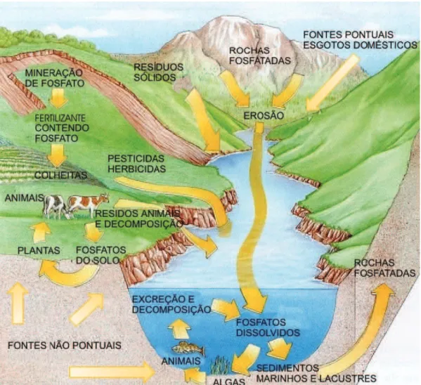
WATERSHED is the biogeophysiographic unit drained by a river, lake,reservoir or ocean. the concept of the watershed as a unit of research, management and the application of basic information stems from the long evolution that began in a practical sense with the implementation of vollenweider’s concept of load (1968) and culminated in Likens’ studies from 1984 and 1992, which demonstrated the experiments and long-term research carried out at Hubbard-Brook, a small watershed in the united states.
P
h
o
to
: e
li
as G
ri
m
b
er
the concept is therefore well-established and consolidated today, representing a considerable process of management decentralization based on research and innovation applied to each watershed. In this context, spatial and temporal scales become fundamental subjects of consideration.
Figure 1 represents the concept of a watershed in all the key components for research and management.
In this article, the authors will summarize the existing knowledge and its application in the management of the tietê/Jacaré watershed in são Paulo state.
Source: Modiied from dobson & Beck (1999).
Figure 1 – the watershed as a unit.
The Tietê/Jacaré Watershed and its main characteristics
the state of são Paulo currently has 22 Water Resource Management units (22 WRMus), and these are in need of articulation in terms of research, management and the application of innovations. Figure 2 presents these
Figure 3 - Municipalities located within the tietê/Jacaré watershed. Figure 2
management units and their spatial distribution throughout the state of são Paulo, with unit 13, the tietê/Jacaré watershed, marked in red center-state. Figure 3 outlines the main characteristics of the tietê/Jacaré watershed and the 34 municipalities it contains.
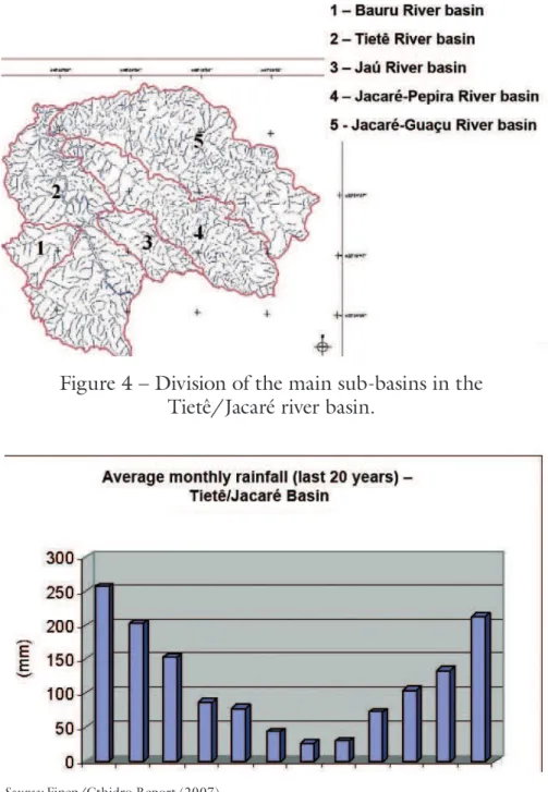
this watershed, located at the center of the state of são Paulo (between 49°32’ - 47°30’ longitude and 21°37’ and 22°51’ latitude), encompasses three main rivers: the tietê (a 150-km stretch from the Barra Bonita dam to the Ibitinga dam), the Jacaré-Guaçu and the Jacaré Pepira. this unit contains three reservoirs: Bariri, Ibitinga and WRM Carlos Botelho (Lobo/Broa). the watershed’s drainage area covers some 11,749 km2. according to Koppen’s
classiication, the unit’s climate ranges from wet tropical (october to March) to dry winter (april to september). Relief is variable, peaking at 800m above sea-level in the são Carlos region, home to the numerous riverheads that feed the watershed. the tietê/Jacaré unit falls within the são Paulo state Peripheral depression, where lie the Bauru/serra and Geral/Botucatu aquifer systems. the basin is largely formed by deep to moderate quartzite sandy soils, with some purple eutrophic latosol.
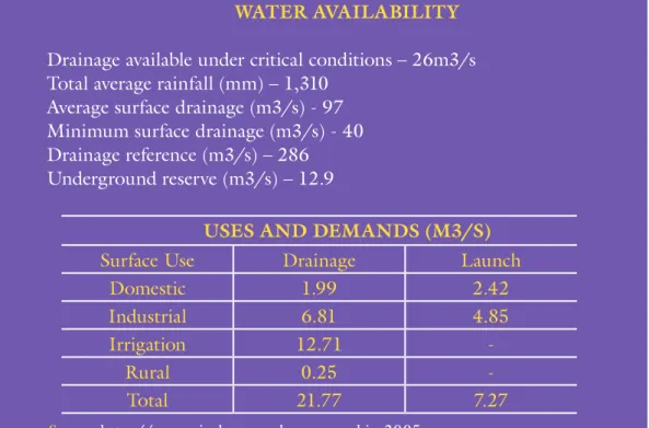
table 1 gives a breakdown of water availability and uses in the tietê/Jacaré watershed.
table 1 – Water availability in the tietê/Jacaré watershed and its multiple uses
WATER AVAILABILITY
drainage available under critical conditions – 26m3/s total average rainfall (mm) – 1,310
average surface drainage (m3/s) - 97 Minimum surface drainage (m3/s) - 40 drainage reference (m3/s) – 286 underground reserve (m3/s) – 12.9
USES AND DEMANDS (M3/S)
surface use drainage Launch
domestic 1.99 2.42
Industrial 6.81 4.85
Irrigation 12.71
-Rural 0.25
-total 21.77 7.27
Figure 4 shows the main sub-basins.
Figure 5 shows the average monthly rainfall in the tietê/Jacaré River basin (over the last 20 years), attesting to more intense rainfall during summer and lower precipitation during winter. annual rainfall is in the order of 4,400 mm.
Figure 4 – division of the main sub-basins in the tietê/Jacaré river basin.
Source: Finep/Cthidro Report (2007)
Study methodology
during a period of three years, from 2005 to 2007, the International ecology Institute carried out extensive studies in the tietê/Jacaré basin. these studies were applied in the identiication of key problems using different technologies. a summary of the methodology is presented below:
Geoprocessing to identify soil usage, urban areas, water systems and
•
areas of natural vegetation. areas more susceptible to erosion were identiied and the main soil uses mapped.
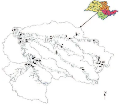
Watershed quality analyses were conducted at representative sample
•
points on the main rivers throughout the tietê/Jacaré basin (Figure 6). these analyses determined the key physical, chemical and biological conditions and the crucial sources of contamination and eutrophication. sporadic and non-sporadic nutrient loads were identiied, especially of n and P, through water quality analyses in the tributaries; the contribution of suspended particles generated through soil use and vegetal cover was also estimated. the benthic community indicative of water quality was also studied. degrees of contamination by heavy metals, pesticides and herbicides were likewise ascertained. Creation of a database covering water-related information, water
•
availability and demands, soil use, climatologic data and economic information on the watershed, its population and their multiple water uses.
Source: Finep/Cthidro Report (2007)
Soil uses, economic activities
and vulnerabilities in the Tietê/Jacaré Watershed
throughout the 34 municipalities in the watershed area, with a combined population of some 1,200,000 inhabitants, the main economic activities
are centered in agribusiness (sugar and ethanol plants, mining, tannery and smelting). the main soil uses are therefore characteristic of cattle ranching and agro-industry.
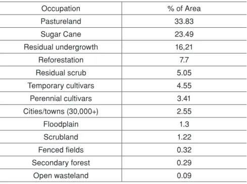
In the rural zone there are vast sugar cane plantations, orange groves, pasturelands and swathes of reforestation with Eucaliptus sp and Pinus sp. the basin area retains only 11.31% of its native cover, which consists largely of scrubland and riparian forest along the tributaries.
as a representative example of soil use, tables 2 and 3 present percentage breakdowns for the different soil uses/occupations and types of natural area for the two sub-basins.
table 2 – uses and occupations of soil in the Jacaré-Guaçu River Basin (%)
Occupation % of Area
Pastureland 33.83
Sugar Cane 23.49
Residual undergrowth 16,21
Reforestation 7.7
Residual scrub 5.05
Temporary cultivars 4.55
Perennial cultivars 3.41
Cities/towns (30,000+) 2.55
Floodplain 1.3
Scrubland 1.22
Fenced fields 0.32
Secondary forest 0.29
Open wasteland 0.09
Source: souza (1996).
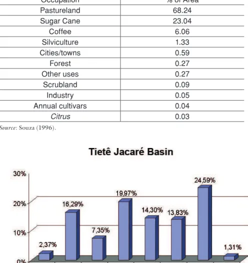
Figure 7 gives a breakdown of soil use in the tietê/Jacaré basin. the main vulnerabilities caused by soil use, economic activities and existing urban settlements in the tietê/Jacaré basin are:
the discharge of untreated domestic waste (sewage) by most of
•
table 3 – uses and occupations of soil in the Jaú River Basin (%)
Occupation % of Area
Pastureland 68.24
Sugar Cane 23.04
Coffee 6.06
Silviculture 1.33
Cities/towns 0.59
Forest 0.27
Other uses 0.27
Scrubland 0.09
Industry 0.05
Annual cultivars 0.04
Citrus 0.03
Source: souza (1996).
Source: Based on Landsat imagery (2004)
Figure 7
Percentage of areas used for human activities and areas of native vegetation in the tietê/Jacaré watershed.
extensive tracts of land occupied by cultivars, producing large
•
quantities of particulate matter, which causes losses of 20 tons of soil per hectare1 per year1, silting rivers and reservoirs and compromising
water quality. the use of fertilizers and pesticides increases water body vulnerability to these contaminants and increases the cost of water treatment.
Increase in the number of non-sporadic sources of nitrogen and
•
the lack of vegetation in a considerable area of the basin compromises
•
the buffer effect such vegetation would normally have, worsening the drainage and silting of substances and elements into the watercourses (tundisi et al., 2006).
Wetlands that could otherwise serve as important watershed buffers
•
(tundisi & Matsumura-tundisi, 2008) are also compromised by the advancing agricultural frontier. the whittling of these areas is another point of vulnerability for the watershed.
the pollution of urban rivers due to degradation in urban areas and
•
bad environmental management in the municipalities. damage to rivers in the majority of the municipalities affects the entire watershed, introducing contaminated water to the mainstems.
Rising water demand in urban regions and growing use of water for
•
irrigation, especially during the dry winter, aggravate the natural water deicit that occurs during this period.
damage to aquifers through improper soil use and wastewater
•
emissions. Lack of vegetation compromises reload and leads to higher levels of aquifer contamination.
Loss of native terrestrial and aquatic species caused by the absence of
•
vegetation, water pollution and the introduction of exotic species of ish to reservoirs (Rocha et al., 2005).
a recent vulnerability in the watershed area has been the presence of
•
the golden mussel (Limnoperna fortunei), an invasive species that has wrought incalculable damage upon aquatic systems, causing mounting maintenance costs by altering conduits, piping and structures. this invasive species has already caused extensive damage to the reservoirs and structures of the Prata Basin (Penchaszadeh, 2005).
the multiple uses of hydric resources from the watershed are diverse:
•
public supply; transport and navigation on the reservoirs; ishing and aquiculture; irrigation; tourism and recreation on the rivers and reservoirs; industrial uses; tanning and mining. together, these uses generate waste that contributes to the heightened vulnerability of the watershed.
Management proposal
Considering the availability of and demand for water resources, the key economic activities practiced in this Management unit, and the main vulnerabilities that threaten it, a proposal for the application of the existing knowledge was drafted. this proposal suggests the following approaches:
valorization of the ecosystemic services (Mea, 2003).
•
Integration of economic, social and environmental processes on
•
is: given the set of human actions and activities in course and the availability of water resources in the region, which of the watershed’s vocations should be maintained and how can it/they (currently mostly agricultural) be adapted to suit that availability?
one of the most important vocations is large-scale agribusiness,
•
followed by localized activities in the different municipalities. development of a
• watershed quality index; this index proposes the following two categories: the condition of the basin as determined by general characteristics, soil use and water quality; and its vulnerability, especially in relation to public supply, eutrophic potential and the determination of areas of impact on human health and water quality. these indicators, developed by Matsumura-tundisi (2006) and dupas et al. (2006), entail the following:
Biotic integrity index with ish parasite metric – variations in water a)
quality very often lead to an increase and diversiication of ish parasites (silva-souza et al., 2006).
Quality indicators for water used in public supply. b)
sediment contamination indexes. c)
Water quality in terms of toxic pollutants, pesticides, herbicides and d)
heavy metals.
Index measuring loss of wetlands. e)
Percentage of forest area under preservation or lost in the watershed f)
area.
of special interest in the vulnerability category are: aquatic species at risk (Rocha et al., 2006)
•
toxic pollutant loads.
•
urban drainage potential.
•
Rural drainage potential.
•
demographic changes.
•
Possible impact on surface and underground waters.
•
the management proposal should include future scenarios tailored to a 30-year timeframe. Issues proposed for these scenarios are:
Water usage in agriculture: current and future trends as per type of
•
cultivar and agricultural production.
Rate of population growth and the potential for urbanization and the
•
discharge of domestic waste that goes with it.
Hydrological alterations and oscillations in water availability caused
•
and adjustments to the economy and in water supply to economic processes, including a reduction in demand; the fact that the potential for river and reservoir eutrophication and contamination may rise due to global changes (Pamolare, 2001; tundisi & Mataumura-tundisi, 2008; Pearl & Huisman, 2008).
scenarios concerning the aquifers: current use of groundwater,
•
projected uses and their repercussions on the reserve and quality of groundwater.
scenarios concerning the impact of basic sanitation, speciically
•
in sewage treatment, and the physical, chemical and biological responses elicited from the rivers and reservoirs of the watershed. negative scenarios should refer to the effects of non-treatment of sewage/wastewater and continued/worsened contamination and eutrophication over the next thirty years.
scenarios on soil use and its impacts on erosion, sediment transport
•
and river/reservoir silting. estimates of silting in reservoirs due to soil use and lack of vegetal cover.
scenarios on the effects of reforestation within the watershed area
•
using native species and the maintenance of vegetation and riparian forest mosaics, fundamentally in the preservation of the springheads and water quality (tundisi et al., 2006).
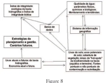
Figure 8 maps the integrations of the database, ecological integrity indexes for the watershed and their role in the planning and management of the basin.
Figure 8
Integration of the database, current and future soil uses and economic activities with planning and management strategies for the tietê/Jacaré
Future actions for the conservation and recuperation of the Tietê/Jacaré watershed
among the effective actions proposed, the following warrant special mention:
sewage treatment in the municipalities
•
Reforestation using native species
•
Recuperation of riparian forest
•
Conservation and recuperation of wetland
•
Control of industrial efluents
•
education for the population on sustainability
•
Promotion of scientiic diffusion projects for the population
•
Recovery of hydroelectric reservoirs
•
Intensive monitoring and control of the main sporadic source sites
•
training for municipal water resource managers
•
establishment of an ongoing process of information and consultation
•
for the tietê/Jacaré Watershed Committee with a view to fostering the use of the database and the survey indings in Basin management. these future actions are being discussed at municipal level and by the tietê/Jacaré Watershed Committee in order to develop mechanisms for implantation in the next few years. the application of hydrological and eco-technological concepts will be developed in conjunction with local city halls in the tietê/Jacaré basin (Zalewski, 2008).
Acknowledgements
the authors would like to thank the Finep/Cthidro project for its support through process 01.04.0999.01 and the CnPq and Fapesp for their continued support for projects in the tietê/Jacaré watershed.
Bibliographic references
doBson, C.; BeCK, G. G. Watersheds: a practical handbook for healthy water. Canada: Friensens, altona, Manitoba, 1999.
duPas, F. a. et al. Indicadores ambientais no planejamento e gestão de bacias
hidrográicas. In: tundIsI, J. G.; MatsuMuR a-tundIsI, t.; sIdaGIs GaLLI, C. (ed.) Eutrofização na América do Sul: causas, tecnologias de gerenciamento e controle. IIe, Iiega, IaP, Ianas, aBC, 2006. p.491-506.
LIKens, G. e. Beyond the shoreline: a watershed ecosystem approach. Verh. Internat. Verh. Limnol., v.22, p.1-22, 1984.
MatsuMuR a-tundIsI, t. (Coord.) desenvolvimento de indicadores de qualidade das bacias hidrográicas do tietê/Jacaré (sP) e do Rio Miranda (Ms) para manutenção da qualidade da água. Projeto Finep/Cthidro, 2006.
MatsuMuRa-tundIsI, t. desenvolvimento de indicadores da qualidade das bacias hidrográicas do tietê/Jacaré (sP) e do Rio Miranda (Ms) para o enquadramento e manutenção da qualidade dos corpos de água. Relatório síntese. Finep/Cthidro, 2008. 37 p. MILLenIuM eCosYsteM assessMent (Mea). Ecosystems and Human Well Being: a framework for assessment. Island Press, 2003. 245p.
PaeRL, H. W.; HuIsMan, J. Blooms like it hot. Science, v.320, p.57-8, 2008. PaMoLaRe Planejamento e gerenciamento de lagos e reservatórios: uma abordagem integrada ao problema da eutroização. unesco, ana, IIe, unep, 2001. 385p.
PenCHasZadeH, P. e. (Coord.) Invasores: invertebrados exóticos en el rio de La Plata y región marina aledaña. Buenos aires: eudeba, 2005.
RoCHa, o. et al. Espécies invasoras em águas doces: estudos de caso e propostas de manejo em são Carlos. são Carlos: editora da uFsCar, 2005.
______. Cianotoxicidade em águas doces tropicais: o impacto da eutroização. In: tundIsI, J. G.; MatsuMuR a-tundIsI, t.; sIdaGIs GaLLI, C. (ed.)
Eutrofização na América do Sul: causas, tecnologias de gerenciamento e controle. IIe, Iiega, IaP, Ianas, aBC, 2006. p.337-52.
sILva-souZa, a. t. et al. Parasitas de peixes como indicadores de estresse ambiental e eutroização. In: tundIsI, J. G.; MatsuMuR a-tundIsI, t.; sIdaGIs GaLLI, C. (ed.) Eutrofização na América do Sul: causas, tecnologias de gerenciamento e
controle. IIe, IIeGa, IaP, Ianas, aBC, 2006. p.373-86.
souZa, a. d. G. Subsídios ao planejamento e operacionalidade de sistemas de
monitoramento da qualidade de água. estudo de caso: bacias do Rio Jaú e Jacaré-Guaçu (sP). são Carlos, 1996. (dissertação de Mestrado) - universidade de são Paulo.
tundIsI, J. G. Bridging water research, innovation and management: enhancing global water management capacity. In: PRoCeedInGs oF tHe vI ReGIonaL WoRKsHoP “Water Resources and Water use Problems in Central asia and Caucasus”. IaP, IWeP, Russian academy of sciences, 2008. p.86-94.
tundIsI, J. G.; MatsuMuR a-tundIsI, t. Limnologia. são Paulo: oicina de textos, 2008. 631p.
tundIsI, J. G. et al. (ed.) Eutrofização na América do Sul: causas, tecnologias de gerenciamento e controle. IIe, Iiega, IaP, Ianas, aBC, 2006. 531p.
______. Conservação e uso sustentável de recursos hídricos. In: BaRBosa, F. a. (org.)
Ângulos da água: desaios da integração. Belo Horizonte: editora da uFMG. 2008. p.157-83.
voLLenWeIdeR, R. a. scientiic fundamentals of the eutrophication of lakes and lowing waters with particular reference to nitrogen and phosphorus as factors in eutrophication. tech. Report. das/CsI6827, oeCd, Paris, 1968.
A
BSTRACT - the tietê/Jacaré watershed is one of the units of management ofwater resources of são Paulo state. são Paulo state has 22 units of management of water resources. a study on the characteristics of the watershed and an evaluation of its environmental situation was carried out from 2005 to 2008. With a population of 1.200.000 inhabitants distributed in 34 towns and an economic activity predominantly agribusiness and industrial activities, this watershed has an extensive hydrographic network, suficient water resources and intense economic activity. the study considered soil uses; vegetation cover; water quality of rivers, reservoirs, underground waters,
erosion processes, vulnerability of the aquatic biota to eutrophication and contamination. With the ecological, hydrological, ecological and economic data, a data bank was
established and a management plan with scenarios, perspectives and integration of planning with future activities was developed. an index of watershed quality was developed as a basis for this planning and management activity.
K
EYWORDS: Watershed, Planning, Management, data bank, Waterresources.
José Galizia Tundisi, Takako Matsumura-Tundisi, Daniela Cambeses Pareschi, Anna Paula Luzia, Paulo Henrique von Haeling and Eduardo Henrique Frollini are researchers at the International ecology Institute, são Carlos –sP. @ - [email protected]. @ - takako@iie. com.br
Received on 7.10.2008 and accepted on 7.14.2008.