Marine Habitats in Conservation Units on the Southeast Coast of Brazil
Habitats Marinhos em Unidades de Conservação na Costa Sudeste do Brasil
DOI:10.34117/bjdv6n4-399Recebimento dos originais: 10/03/2020 Aceitação para publicação: 29/04/2020
Francisco Gleidson da Costa Gastão
Doutor em Ciências Marinhas Tropicais pela Universidade Federal do Ceará (UFC). Instituto de Ciências do Mar (Labomar), Laboratório de Dinâmica Costeira (Labdic), Avenida da Abolição
3207, Fortaleza, Ceará, 60165-081 f.gleidson@ufc.br
Lídia Torquato da Silva
Mestre em Ciências Marinhas Tropicais pela Universidade Federal do Ceará (UFC). Instituto de Ciências do Mar (Labomar), Avenida da Abolição 3207, Fortaleza, Ceará, 60165-081
lidiatorquato@gmail.com
Sergio Bezerra Lima Junior
Doutor em Geologia pela Universidade Federal do Ceará (UFC). Instituto de Ciências do Mar (Labomar), Laboratório de Dinâmica Costeira (Labdic), Avenida da Abolição 3207, Fortaleza,
Ceará, 60165-081 sergioblj@gmail.com
Luiz Fernando Loureiro Fernandes
Doutor em Oceanography pela Texas A&M University System, TAMUS, Estados Unidos. Departamento de Oceanografia e Ecologia, Centro de Ciencias Humanas e Naturais, Universidade
Federal do Espírito Santo, Av. Fernando Ferrari 514, Vitória, ES 29075-910 luiz.ufes@gmail.com
Cláudio Antônio Leal
Mestre em Ciências Marinhas Tropicais pela Universidade Federal do Ceará (UFC). Petróleo Brasileiro S.A (Petrobras), Unidade Operacional do Espírito Santo (UO-ES) / SMS/MA,
Av. Fenando Ferrari 1000, Vitória, ES 29075-905 cleal@petrobras.com.br
Alice Barboza Gobira
Engenheira Ambiental pela Universidade Federal do Espírito Santo (UFES).
Petróleo Brasileiro S.A (Petrobras), Unidade Operacional do Espírito Santo (UO-ES) / SMS/MA, Av. Fenando Ferrari 1000, Vitória, ES 29075-905
alicegobira@gmail.com
Luis Parente Maia
Doutor em Ciencias del Mar pela Universitat de Barcelona, UB, Espanha. Instituto de Ciências do Mar (Labomar), Laboratório de Dinâmica Costeira (Labdic), Avenida da Abolição 3207, Fortaleza,
Ceará, 60165-081 parente.ambes@gmail.com
ABSTRACT
Continental shelves with diversified physiography, geomorphology marked by rocky reefs, channels, and marginal terraces, besides several terrestrial and marine sediments, have a rich mosaic of habitats ideal for the conservation and reproduction of marine life. This work, as part of the research project "Detailed Study of the Ocean Bed inside the Santa Cruz WLR, Costa das Algas EPA and 2000m Immediate Environment", aims at mapping the marine habitats located in two Conservation Units, Costa das Algas EPA (Environmental Protection Area) and Santa Cruz WLR (Wildlife Refuge), located south of the Doce River mouth, on the southeast coast of Brazil. For this purpose, data on the type, distribution, and composition of seabed sediments, as well as information on the seabed geomorphology using bathymetric data, seabed records by ROV imaging, and benthic fauna at the phylum taxonomic level were determined in the studied areas. The results indicated the presence of five sedimentary facies defined by the terrigenous and marine sedimentation regimes, separated in the vicinity of the -35 m isobath. The sandy-clayey sediments deposited by the fluvial discharges from the region rivers predominate in the first case. On the other hand, the marine sedimentation consists of biolitoclastic and bioclastic sediments, with rhodolith pebbles as well. In addition, three hydrodynamic zones/regions were defined, according to the presence and type of seabed ripples formed by near-bottom waves. The bathymetric data revealed seabed features such as reef structures, or rocky reefs, as well as submerged channels originated by marine regression. This set of characteristics defined eleven marine habitats, and among them, those consisting of biolitoclastic, bioclastic and rhodolith sediments, as well as rocky reefs and submerged channels, which had the greatest abundance of marine fauna and flora organisms. On the other hand, the habitats defined by the terrigenous sedimentation had a lower abundance of organisms. This finding indicates that the marine sedimentation regime predominated over the terrigenous, especially in the Costa das Algas EPA, which generally represents an area with high potential for proliferation and preservation of marine benthic and demersal fauna and flora. In view of this, the mapping of the Conservation Units presented here for the first time on a detailed scale can help to understand the importance of these areas for the preservation and maintenance of marine life.
Keywords: Conservation Units, Costa das Algas EPA, marine habitats.
RESUMO
Plataformas continentais que apresentam diversificada fisiografia, com geomorfologia marcada por recifes rochosos, canais e terraços marginais, além de vários sedimentos de origem terrígena e marinha, possuem um rico mosaico de habitats ideais à conservação e reprodução da vida marinha. O presente trabalho, parte do projeto de pesquisa “Estudo Detalhado do Leito Oceânico no Interior da RVS de Santa Cruz, APA Costa das Algas e Entorno Imediato de 2000m”, teve como objetivo mapear os habitats marinhos situados nas duas Unidades de Conservação APA (Área de Proteção Ambiental) Costa das Algas e RVS (Refúgio da Vida Silvestre) de Santa Cruz situadas na costa sudeste do Brasil, ao sul da Foz do Rio Doce. Para tanto foram adquiridas informações sobre o tipo, distribuição e composição dos sedimentos do fundo marinho, informações sobre a geomorfologia de fundo, através de dados batimétricos, bem como registros do fundo por ROV e dados da fauna bentônica no nível taxonômico do Filo. Os resultados mostraram a existência de cinco fácies sedimentares definidas pelos regimes de sedimentação terrígeno e marinho, separados nas proximidades da isóbata de -35 metros. No primeiro caso dominam os sedimentos areno-argilosos depositados a partir das descargas fluviais dos rios da região. Já na sedimentação marinha os sedimentos são biolitoclásticos e bioclásticos, além de serem compostos por seixos de rodolitos. Além disso, foram definidas três áreas hidrodinâmicas, de acordo com as marcas onduladas no sedimento de fundo. Os dados batimétricos revelaram a existência de feições de fundo como estruturas recifais, ou recifes rochosos, além de canais submersos originados pela regressão marinha. Este conjunto de características definiram onze habitats marinhos, dentro os quais os compostos por sedimentos biolitoclásticos, bioclásticos e rodolitos, além de recifes rochosos, e canais submersos foram os que apresentaram maior abundância de organismos da fauna e flora marinhas. Por outro lado, os habitas
definidos pela sedimentação terrígena apresentaram menor abundância de organismos. Isso reflete para área estudada a predominância do regime de sedimentação marinha sobre a terrígena, sobretudo na APA Costa das Algas, o que configura, de uma maneira geral, área de alto potencial à proliferação e preservação da fauna e flora marinhas bentônica e demersal. Diante disto, o mapeamento das Unidades de Conservação, aqui apresentados pela primeira vez em escala de detalhe, pode ajudar na compreensão da importância destas áreas para a preservação e manutenção da vida marinha.
Palavras-Chave: Unidades de Conservação, APA Costa das Algas, habitats marinhos.
1 INTRODUCTION
The continental shelf in southeast Brazil has very peculiar and diversified physiography, with geomorphology marked by reefs, channels, marginal terraces, with expressive widths in many cases such as the Abrolhos Bank. It is also characteristically covered by biodetritic sediments (Coutinho, 2000) and rhodolith banks (Pereira- Filho et al., 2011; Amado-Filho et al., 2012a; Amado-Filho et al., 2012b).
According to Coutinho (2000), beginning in the mouth of Rio Doce, the continental shelf average width is 48 km with the presence of several volcanic intrusions that favor the development of biogenic structures. Further south, in the State of Espírito Santo, there are two Conservation Units (CUs) known as the Costa das Algas EPA (Environmental Protection Area) and the Santa Cruz WLR (Wildlife Refuge) that correspond to a region with great variety of marine, calcareous and non-calcareous macroalgae that provide substrate, shelter and feeding to a diversified benthic, demersal and pelagic fauna (Brasil, 2006), as well as biolitoclastic and litoclastic sediments, forming a mosaic of seabed environments (Longo and Amado-Filho, 2014) with distinct biotic and abiotic characteristics. Silva and Bastos (2013) mention that a considerable share of the litoclastic sediments on the continental shelf corresponding to the CUs originate from the Rio Doce, a fluvial system also responsible for discharging the tailings in the dispersion plume caused by the rupture of the Fundão dam in Mariana, MG, on November 5, 2015.
The knowledge on the marine environments and delimitation of areas with the same geological and oceanographic characteristics, through direct and indirect mapping, becomes important not only for the understanding of habitat potential for certain animal and plant organisms (Greene et al., 2007), but also is a critical prerequisite for current and future decision-making regarding marine management policies (Andersen et al., 2018) and their protection (Pitcher et al., 2016).
According to the European Nature Information System (EUNIS) (2007 revised in 2012), the habitats are classified hierarchically according to abiotic and biotic factors and are sized from a set of physical and biological parameters, such as substrate characteristics and biological zones. Begon et al. (1990) proposed a classical definition for habitats considering as the main object the physical
space, which can be understood as the environment occupied by the plants and animals. To this space are assigned specific characteristics that support the survival or even the reproduction of those organisms.
In the literature, studies show that the physiography, depth, substrate hardness, sediment texture, seabed morphology, as well as associated biology are widely used for classifying and mapping marine habitats (Jones and Syms, 1998; Greene et al., 1999; Yoklavich et al., 2000; Kenny et al., 2003; Kendall et al., 2005; Greene et al., 2007; Moura et al., 2009; Amado-Filho & Pereira-Filho, 2012; Secchin et al., 2013; Wölfl et al., 2014; Parry et al., 2015). Love et al. (2006) point out that the geology, substrate type and forms, as well as the area texture represented by the sediments and sedimentation processes, are abiotic factors responsible, in most cases, for the distribution and abundance of certain demersal and benthic organisms.
The mapping of marine habitats has been taking place all over the world in recent decades, using universal methods that consist of applying a wide variety of instrumental and methodological techniques. The methods for mapping the seabed have been evolving according to the objective and scale (Spalding & Greenfel, 1997; Kenny et al., 2003; Solan et al., 2003; Diaz et al., 2004; Prates, 2006; Secchin et al., 2013).
Geophysics, based on the surveys of the Multibeam Sonar System (MBSS) (Todd et al., 1999; Brown & Blondel, 2008) and Lateral Scan Sonar (Moura et al., 2013), is a potential tool for habitat mapping as it provides high spatial resolution and complete information on the seabed. These systems, together with Remote Operating Vehicles or ROVs (Monteiro et al., 2008; Wölfl et al., 2014) also provide good field results, favoring a more accurate mapping of habitat distribution, based on in situ observations of biotic and abiotic conditions. It is noteworthy the importance of using sedimentology (Wölfl et al., 2014) as a complementary part of the geological and textural knowledge on the seabed when mapping the habitats.
In this context, this study as part of the research project named "Detailed Study of the Ocean Bed inside the Santa Cruz WLR, Costa das Algas EPA and 2000m Immediate Environment", aimed to map the marine habitats of the CUs located in Espírito Santo, on the southeast coast of Brazil, based on type, distribution and geochemistry data of the seabed sediments, bathymetric data, as well as seabed records by ROV imaging, and the benthic fauna data at the phylum taxonomic level.
2 MATERIALS AND METHODS
2.1 STUDY SITE
The study area comprises the Costa das Algas EPA and Santa Cruz WLR, from the coastline to the continental slope of the Espírito Santo state (Figure 1a).
The predominant climate in the area is tropical humid, hot and rainy, with average annual temperatures of 23ºC during most of the year (MMA, 2005). The coastal area accumulates 1000 mm precipitation during the year, strongly influencing the fluvial discharge of the region rivers, such as the Rio Doce to the north of the area, and the Piraquê-Açu, Piraquê-Mirim, and Reis Magos rivers that flow into the CU areas.
Albino et al. (1999) report the occurrence of a semidiurnal microtidal system in the area, with a height less than 2 m, oscillating twice a day, and averaging 1.4 m. The ocean wave climate is influenced by the atmospheric systems of the east coast of Brazil, such as the South Atlantic Subtropical High and the extratropical cyclones (IEMA, 2014). Nogueira (2014) reports that in the summer, the study area is characterized by lower energy waves, with significant height (Hs) ranging from 1.6 to 3.34 m, a period of 8.6 to 18.1 s, and ENE direction. In winter, the energy increases, with significant height (Hs) varying from 1.86 to 4.34 m, period of 10.4 to 18.5s, and mean SE direction. The current regime of the studied area is influenced directly by the complex oceanic topography (Fragoso, 2004). Castro Filho et al. (2015) reported a high incidence of divergent coastal currents in the surface vicinity during summer, with speeds varying from 0.1 to 0.4 m.s-1 and NE direction; and near-bottom currents pointing toward the coast, with speeds ranging from 0.1 to 0.4 m.s-1, and ESE direction. The speed and direction are similar in the winter, only the direction of the near-bottom currents change from ESE to NE for the lower (0.1 to 0.2 m.s-1) and to SW for the higher (0.2 to 0.4 m.s-1) velocities.
2.2 SEDIMENT SAMPLING AND SEDIMENTOLOGICAL AND GEOCHEMICAL ANALYSES Sediments of the CU areas were sampled aboard the Abaete vessel during the summer, in 2017 and 2018. The sampling mesh consisted of a total of 50 points, four of which were identified as rocky reefs during sampling (Figure 1b). The Van Veen sampler used for sampling had 0.15m² area and 5 L (5x10⁻³) volume.
The granulometric analysis using the wet and mechanical sieves (Suguio, 1973) was performed in the Laboratório de Oceanografia Geológica (LOG) of the Instituto de Ciências do Mar (Labomar) of the Universidade Federal do Ceará (UFC). Following Wentworth (1922), the ANASED 5.0 software (Lima et al., 2001) was used for grading/separating into the following classes, pebble/gravel (>4 and 2 mm), sand (>64 μm to <2 mm), and mud (<64 μm). The calcium carbonate (CaCO3) and organic matter (OM) contents were determined by the gravimetric (Loring and Rantalla,
1992) and calcination (Davies, 1974) methods, respectively.
The bottom sedimentary facies by sampling point were characterized by processing the granulometric and CaCO3 data together in the ANASED 5.0 software (Lima et al., 2001), based on
Larsonneur, modified by Dias (1996). The codes refer to the Portuguese terminology used for sedimentary facies classifications, with each part of the terminology corresponding to a letter or code. This study adapted the codes of the facies terminology to the English language. Thus, the Terrigenous (T) mud (m) facies corresponds to the Tm code, as well as the Litoclastic (L) sand (s) - Ls, Biolitoclastic (BL) sand (s) - BLs, Bioclastic sand - Bs, and Rhodoliths - R.
The biodetritic content was analyzed using a magnifying glass, according to the methodology proposed in Tinoco (1989) and separated into three granulometric fractions (pebbles and gravels, coarse and fine sand). Subsequently, the material was quantified and photographed. The biodetritic components were screened and classified according to the phylum taxonomic level, based on Tinoco (1989) and Matthews-Cascon & Martins (2006).
The geochemical analysis determined the metal contents (barium, chromium, manganese, vanadium, and zinc) in the sediment of the 50 sampled points by inductively coupled plasma optical emission spectrometry (ICP-OES) (EPA, 1996).
2.3 MARINE SEABED MORPHOLOGY
The seabed morphology was interpreted from the interpolation of the single-beam bathymetric data of the onboard records of the Brazilian Hydrographic Center and the Research Project "Detailed Study of the Ocean Bed inside the Santa Cruz WLR, Costa das Algas EPA and 2000m Immediate Environment". The statistical method used was the Inverse Distance Weighted (IDW) interpolation, in a GIS (Geographic Information System) environment in the QGIS software version 2.4 "Chugiak" (Sherman et al., 2007).
Information on the seabed morphology from the works of Boni et al. (2018) and Vieira et al. (2018) was also used since these studies were conducted in the same study area and research project mentioned above.
2.4 BENTHIC MACROFAUNA SAMPLING AND IDENTIFICATION
The benthic fauna was sampled in 25 points in triplicate using a Van Veen dredge, where the substrate consisted mostly of sand and mud fractions. Five bottom trawls between 25.4 and 51 m depths were also conducted (Figure 1b), and the material was used to characterize the benthic macrofauna at the phylum taxonomic level.
In the Zoobenthos laboratory of the Labomar/UFC, the benthic macrofauna was analyzed following the steps, washing, sorting and counting under a stereoscopic microscope. The quantitative data were recorded by phylum on a spreadsheet to determine/classify the benthic community of the study area. The data of each replica (part of the triplicate) were added, completing the abundance of
the total of copies for each sampling point. Organisms of the following phyla were identified Bryozoa, Arthropoda (Crustacea), Annelida (Polychaeta), Cnidaria, Mollusca, Nemertea, Nematoda, Echinodermata, Sipuncula, Echiura, Entoprocta, Chordata (Urochordata), and Porifera.
Figure 1. Map of the study area and the CUs on the southeast coast of Brazil (a). Sediment sampling, benthic macrofauna, trawling and ROV imaging on bathymetry (b) (bathymetric data from the onboard records of the Brazilian Hydrography Center and the Research Project "Detailed Study of the Ocean Bed inside the Santa Cruz WLR, Costa das
Algas EPA and 2000m Immediate Environment”)
2.5 MARINE BOTTOM IMAGING WITH ROV
The seabed was imaged in 50 points with an ROV (Remotely Operated Vehicle) aboard the Mar Azul vessel at the speed of approximately 1 node; the imaging lasted 10 minutes on average to guarantee a sample profile of approximately 300 meters at each point. The BlueROV2 equipment used has a field of view of 110° and a resolution of 1920×1080 pixels. The images allowed observing the substrate type (sediment) and identifying the associated marine fauna and flora.
2.6 INTERPRETATION AND DATA MODELING, CLASSIFICATION AND MAPPING OF SEDIMENTARY FACIES AND MARINE HABITATS
The sedimentary facies mapping relied on the definition of individual facies at each sampling point, following the classification proposed by Larsonneur, modified by Dias (1996). A value corresponding to the classified facies was assigned to each point. From the value distribution in the
study area, the data were interpolated by the Inverse Distance Weighting (IDW) in QGIS version 2.4 "Chugiak" (Sherman et al., 2007), to generate the map corresponding to each sedimentary facies.
The classification system for delimiting and mapping the marine habitats was based on the seabed physiography (Kendall et al., 2005 and Greene et al., 2007), sedimentary facies mapping, sediment geochemistry, ROV data, and benthic macrofauna identification.
The data integration allowed to interpret, define and map the marine habitats, according to the classification of potential marine habitats by Greene et al. (2007). The authors propose a classification based on a set of characters or codes for a GIS environment, in which each code refers to a particular feature of the seabed environment, geological, geomorphological or biological. The order, characteristics, and identification of the features used in this work to define the twelve marine habitats, are shown in table 1. It is worth mentioning that the character in parentheses, corresponding to the grain fraction of the sediment, was adapted to the codes of the facies classification of Larsonneur, modified by Dias (1996).
3 RESULTS
3.1 DISTRIBUTION AND COMPOSITION OF BOTTOM SEDIMENTS AND SEDIMENTARY FACIES
In general, average grain size distribution of the sediments varied with depth, so that the finer sediments were located at depths less than 35 meters and the coarser, at greater depths. The predominant sandstone classes are 31.7% of coarse sand (0.5 to 2 mm), followed by 20% of fine sand (0.17 to 0.06 mm), 18.7% of pebbles and gravels (≥ 4 to 2 mm), 15% of medium sand (0.35 to 0.25 mm), and 14.6% of mud (<0.06 mm) (Figure 2).
Table 1. Order, characteristics and identification of the characters used for classifying the potential marine habitats proposed by Greene et al. (2007).
Code or Character
Character Order
Type of Mapping or Scale
(Greene et al. 2007)
Classification of Greene et al. (2007) or Classification of Larsonneur (*)
“S”
1° Indicates one of the nine types of mega-habitats
Shelf, continental and island shelves (0-200 m)
“F” Flanks, continental slope, basin/island flanks (200-3000
m)
“s”
2° Type of material, whether consolidated or unconsolidated
Soft bottom, sediment cover
“h” Hard bottom “(Tm)” 2° in parenthesis Sediment Characteristics (granulometric fraction) Terrigenous mud* “(Ls)” Litoclastic sand* “(BLs)” Biolitoclastic sand* “(Bs)” Bioclastic sand* “(R)” Rhodoliths*
“e” Exposure, bedrock
“g” Gully, channel
“w” Sediment waves (10 cm to <1 m amplitude) and dunes
“[a-b]”
4° Reef Flora and Fauna
Red algae
“[a-g]” Green algae
“c” Corals “1” 5° Slope of bottom Flat (0-5°) “2” Sloping (5-30°) “3” Steeply Sloping (30-60°) “A” 6° Bottom rugosity
Very Low Rugosity
“B” Low Rugosity
“C” Moderate Rugosity
Figure 2. Percentages of the granulometric fractions in the study area based on the classification of Wentworth (1922).
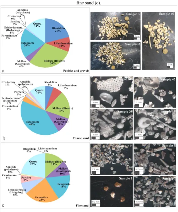
The sediment with the most pebbles and gravels is distributed in the ENE portion of the area, between 50 and 70 m deep (Figure 3a), near the continental slope, but also occur near the coastline in the NW portion of the area. Biodetritic fragments of calcareous algae from rhodoliths and lithothamnium, as well as other benthic organisms of the phyla Mollusca (gastropods and bivalves), Ectoprocta (Bryozoa) and Echinodermata (Figure 4a) constitute this sediment fraction.
From the SW to NE portion of the area and crossing over the central part, coarse sandy sediments (Figure 3b) occur between 10 and 70 m deep. These sediments consist of biodetritic fragments from rhodolith and lithothamnium, in smaller quantities compared to the pebble and gravel fraction, besides shells of Mollusca (gastropods and bivalves), Ectoprocta (Bryozoa), Foraminifera, Annelida (polychaetae), Crustacea, Porifera, Echinodermata (hedgehog) (Figure 4b).
The medium sand fraction is the least represented among the sand class fractions, being concentrated only in a small area at the northern edge of the study area, at 45 m deep (Figure 3c).
Further, the biodetritic components were not identified due to poor representativeness among the sand fractions.
The fine sandy sediments are distributed between the NE and NW sectors of the area, between 25-60 m deep (Figure 3d). They consist especially of fragments of benthic organisms of the phylum Foraminifera, followed by fragments of the phyla Mollusca (gastropods and bivalves), Ectoprocta (bryozoan), Echinodermata (hedgehog), Porifera and Crustacea, as well as quartz mineral grains (Figure 4c). However, calcareous alga fragments from rhodoliths and lithothamnium do not occur in these sediments. The mud fraction is better distributed from the coastline, near the mouth of the Piraquê-Açú and Piraquê Mirim rivers up to a depth of approximately 30 m (Figure 3e).
The sediments with the highest CaCO3 (from 70 to 93%) contents are located in the northeast,
east, and southeast of the area, between 50 to 70 m deep, but also occur in the SW sector, between 35 and 40 m deep (Figure 3f), both associated with occurring rhodoliths and biodetritus. A large sediment band with CaCO3 varying from 60 to 70% occurs in the central portion, NE to the SW of
the area, associated with a mixture of terrigenous and carbonate sediments. The sediments with less than 50% CaCO3 contents are located less than 35 m deep.
The CaCO3 distribution corroborates the granulometric classification, the depth variation (Figure 3g), and consequently the biodetritus distribution in the area, which defined two main sedimentation zones, one more terrigenous found up to 40 m deep and another carbonate zone, at depths greater than 50 m. Additionally, between 35 and 50 m deep, a mixture zone of siliciclastic and carbonate sediments is observed.
Figure 3. Distribution of the grain fractions (%) and calcium carbonate content in the seabed sediments. (granulometry based on Wentworth, 1922).
Figure 4. Total relative abundance of biodetritic fragments of the fractions, pebbles and gravels (a), coarse sand (b) and fine sand (c).
Geochemistry and organic matter (OM) also contributed to understanding the distinction between these two major sedimentation regimes in the studied area. The muddier to sandy sediments closer to the coast, with low CaCO3, have higher metal contents such as chromium (Cr), zinc (Zn),
vanadium (V), manganese (Mn), and organic matter as well. On the other hand, the coarser sandy sediments, pebbles and gravel, had higher CaCO3 contents due to the biodetritic components, less organic matter, and higher barium (Ba) levels, as observed in the Cluster Analysis graph (Figure 5).
Figure 5. Cluster analysis of the concentrations of metals and organic matter (OM), CaCO3 and grain size classes of
seabed sediment samples. Red box corresponds to the terrigenous sediments and blue box to the biodetritus-rich sediments.
From the sediment distribution and composition data, five sedimentary facies were defined for the CU areas. The Rhodolith (R) and Bioclastic sand (Bs) facies consisting of sediments with carbonate above 70% and sediments with grain fractions varying from pebbles to coarse sand; the Biolitoclastic sand (BLs) facies consisting of the coarse sand fraction with calcium carbonate varying from 50 to 70%; and, finally, the Litoclastic sand (Ls) and Terrigenous mud (Tm) facies consisting of fine-grained sand to mud sediments with calcium carbonate contents below 30% (Figure 6).
3.2 ASPECTS AND SEABED CHARACTERISTICS OF SEDIMENTARY FACIES
The ROV imaging, together with the interpolation of the single-beam bathymetry data provided by onboard records of the Brazilian Hydrographic Center and the Research Project "Detailed Study of the Ocean Bed inside the Santa Cruz WLR, Costa das Algas EPA and 2000m Immediate Environment", allowed understanding the geomorphological and sedimentological characteristics of the sedimentary facies of the study area.
Figure 6. Distribution of sedimentary facies (according to Larsonneur, modified by Dias, 1996).
The bioclastic sand sedimentary facies occupies the largest area of the Costa das Algas EPA and a small part of the Santa Cruz WLR, extending over a 402 km² area. The most central sectors of the continental shelf have an average slope of 0.20° that increases to 1.2° near the continental slope. The morphology is also marked by channels that cross the rhodolith facies while bottom sediments consist mostly of dead rhodolith fragments, as well as carapaces of other benthic organisms (Figures 7a, and 7b). Symmetrical ripples (Figure 7c) resulting from the hydrodynamic action of the near-bottom waves and currents are observed in this substrate at the contact with the terrigenous sand facies, between 35 and 40 m deep. They also appear between reef structures at 35 m deep (Figures 7d, 7e, and 7f). The biolitoclastic and bioclastic sand facies have similar characteristics, differing only regarding calcium carbonate contents since it composes part of the terrigenous material of the litoclastic sand facies. The biolitoclastic sand facies also consist of sparser biodetritic fragments.
Figure 7. Bottom characteristics of the bioclastic sand facies. DTM of the bioclastic sand facies between reef structures (a). Fragments of dead rhodoliths and other benthic organisms (b and c). Symmetrical ripples (d). Reef structures close
to the bioclastic sand facies. (e, f).
The rhodolith sedimentary facies was the second largest in area, with 244 km², inserted in the Costa das Algas EPA Conservation Unit, the quieter/calmer zone of the continental shelf, where the hydrodynamic action of the waves is less intense or almost non-existent since no seabed ripples were detected on this substrate. The gentle slope of 0.13° increases slightly to 1.8°near the continental slope, marked by 20m-deep channels (Figure 8a) with 700 m average width. In addition to rhodoliths, red coralline algae such as maerl and lithothamnium also compose the substrate (Figures 8b and 8c).
Its main characteristic are the extensive areas occupied by rhodolith banks that, in many cases, are associated with reef structures (Figures 8d and 8e) between 40 and 60 m deep. Further, biodetritus of red coral algae and some benthic organisms of the phyla Mollusca and Ectoprocta also occur.
Figure 8. Bottom characteristics of the facies Rhodoliths (R). Digital Terrain Model (DTM) of the channels (a). Red coralline algae such as maerl and lithothamnium between rhodolith fragments (b, c). DTM showing the rhodolith facies
relief between reef structures (d). Bank of rhodoliths (e).
The litoclastic sand facies occupies a 174.6 km² area spread across both CUs. The morphology is homogeneous and smooth between 30 and 35 m deep, with a 0.1° slope that increases to 0.23° near
the coastline, between 5 and 25 m deep, with a strong presence of symmetrical and regularly spaced (Figure 9a) linguoid (Figures 9b and 9c) ripples, related to the unidirectional and multidirectional hydrodynamic action of the bottom waves and currents, respectively. Muscovite mica is abundant in this facies sediment, indicating the strong influence of the terrigenous sedimentation. Finally, the terrestrial mud facies occupies the smallest area, 133 km², and practically half of the Santa Cruz WLR area, distributed between the mouth of the Piraquê-Açú, Piraquê-Mirim, and Reis Magos rivers. The morphology is similar to the litoclastic sand facies, with slightly undulating and symmetrical linguoid bottom ripples at the contact with the fine sand from the litoclastic sand facies (Figure 9d). One of the characteristics of the terrigenous mud facies is the high turbidity of the water column (Figure 9e), caused by the hydrodynamic perturbations in the substrate, especially close to the coastline.
Figure 9. Bottom characteristics of litoclastic sand and terrigenous mud facies. Symmetrical bottom ripples on litoclastic sand facies (a). Linguoid bottom ripples on litoclastic sand facies (b, c). Bottom ripples mixing the
3.3 MARINE HABITATS AND ASSOCIATED FAUNA AND FLORA
The bottom geological and geomorphological characteristics of the mapped sedimentary facies divide the study area into three different preferential zones (Figure 10a) according to the hydrodynamics and preferential sedimentation environments. The first, the calm zone starts at the 35 m depth extending up to the continental slope, with no undulating ripples on the substrate due to the lacking hydrodynamic action of more intense waves and currents in this region. The second, the zone of agitation of bottom waves, between 35 and 2.5 m deep, presenting undulating ripples on the substrate caused by the hydrodynamic action of near-bottom waves and currents. Lastly, the intertidal zone, between 2.5 m deep to the coastline, where the changing tides expose and cover the bottom during the low and high tides, respectively.
The sedimentation environments (Figure 10b) were divided into two, one consisting of the sediments from the marine environment (autochthonous), rich in carbonate biodetritus, situated between the 35 m deep and extending to the continental slope; and another composed of siliciclastic sediments of terrigenous or continental origin (allochthonous), located between 35 m dep all the way to the coastline.
Thus, eleven marine habitats (Figure 10c) were mapped based on the preferential hydrodynamic regions, seabed sedimentation environment, and the marine habitat classification proposed by Greene et al. (2007), each with its sedimentological and geomorphological characteristics, and associated marine fauna and flora. The continental slope was mapped as the twelfth habitat; however, this environment was not characterized in detail since it was not sampled.
The Soft unconsolidated mud sediment wave Ss(Tm)w1 habitat, with an area of 128 km², is situated between less than 35 m deep to the coastline at the mouth of the Açú and Piraquê-Mirim rivers, and distributed in two Conservation Units, occupying half of the Santa Cruz WLR area.
This habitat consists of a muddy substrate of continental origin transported by the fluvial discharges into the marine environment. The total area of this habitat corresponds to the terrigenous mud sedimentary facies (Tm). Because it is inserted in the wave agitation zone, the bottom is covered by undulating, symmetrical, linguoid-like ripples. The relief of this habitat is smooth, with slope varying from 0 to 5°.
The benthic macrofauna characterized by the benthos triage based on the material collected by the Van Veen sampler shows that organisms from at least eight phyla are present in the habitat [Arthropoda (Subphylum Crustacea), Mollusca, Annelida (Class Polychaeta), Cnidaria, Echinodermata, Nematoda, Nemertea, and Bryozoa]. The phylum Annelida (Polychaeta) is the most abundant in this habitat benthic macrofauna, accounting for 48% of the total organisms found. The phyla Nematoda, Crustacea, and Mollusca represent 18, 16 and 12%, respectively. The phyla
Echinodermata and Nemertea add up to 6%, and the phylum Cnidaria represents less than 1% of the total.
Figure 10. Distribution of the hydrodynamic zones based on the location of the undulating bottom ripples (a). Sedimentation environments according to the distribution of the tertiary and marine carbonate-siliciclastic sediments
(b). Distribution of marine habitats in the Conservation Units areas (c).
The organisms in the trawl were identified in the P6 and P13 sampling points; seven specimens of the phylum Crustacea and nine of the phylum Mollusca.
The ROV imaging revealed a more desertic environment regarding visible fauna and flora, without algae, and with few benthic fauna animals, such as sea sponges (Figure 11a) and scarce ichthyofauna (Figure 11b).
The Soft unconsolidated sand sediment Ss(Ls)1 habitat is situated north of the study area, covering a 40 km² area in the Costa das Algas EPA Conservation Unit only, between 40 and 50 m deep.
The habitat consists of a sandy substrate of continental origin, corresponding to the litoclastic sand (Ls) sedimentary facies. Due to the location, these sediments are assumed to originate from the fluvial discharge of the Rio Doce, to the north of the Costa das Algas EPA area. This substrate does not have bottom ripples because it is inserted in the calm hydrodynamic zone while the smooth slope varies from 0 to 5°.
The bottom trawl detected four specimens of the phylum Crustacea. The ROV imaging indicated the presence of other animals such as a moray eel (Figure 11c) and a sea sponge (Figure 11d). Algae was not detected in this habitat.
The Soft unconsolidated sand sediment wave Ss(Ls)w1 habitat is located between the depths of 40 m, to the north of the area, and 30 m from the coastline near the mouths of the Piraquê-Açú and Piraquê-Mirim rivers. Like the Soft unconsolidated sand sediment, this habitat consists of siliciclastic sediments of terrigenous origin, besides corresponding to the litoclastic sand (Ls) sedimentary facies, but has undulating bottom ripples because it is situated in the agitation zone of the bottom waves. The smooth slope varies from 0 to 5° but becomes slightly inclined at the contact with the coral reefs.
The benthic macrofauna in the material collected by the Van Veen dredge consisted of organisms of the phyla Bryozoa, Arthropoda (Crustacea), Annelida (Polychaeta), Mollusca, Nemertea, Nematoda, Echinodermata, Sipuncula, Echiura, Chordata (Urochordata), and Entoprocta. Among these organisms, the phyla Annelida (Polychaeta), Mollusca, Arthropoda (Crustacea) and Echinodermata were the most abundant. On the other hand, the trawling material had an abundant presence of organisms from the phylum Echinodermata, with thirteen specimens identified.
The ROV imaging indicated little visible presence of life, detecting only one specimen of sole/plaice fish (Figure 11e) and no algae.
The Soft unconsolidated sand and gravel sediment Ss(BLs)1 habitat is located between the depths of 35 and 50 m, from the north up to the center of the area, almost exclusively in the Costa das Algas EPA CU. This habitat has 198 km² area and represents the interface between terrigenous siliciclastic and marine carbonate sediments, with a bimodal distribution grading from sand to gravel, in addition to a balanced concentration of CaCO3 together with heavy metals. Therefore, it corresponds to the biolitoclastic sand (BLs) sedimentary facies. It lacks bottom ripples, has a smooth relief, and slope not greater than 5°.
The ROV images revealed a more significant presence of ichthyofauna represented by fish shoals (Figure 12a). Further, a marine flora represented by red algae, often close to sea sponges, is already observed in this habitat (Figure 12b). The benthic macrofauna was not identified since the dredge sampling was not done in the areas corresponding to this habitat.
The Soft unconsolidated sand and gravel sediment wave Ss(BLs)w1 habitat has an area of 32 km², almost totally inserted in the Santa Cruz WLR CU, between the depths of 35 and 40 m. The sediment characteristics are similar to the soft unconsolidated sand and gravel sediment, differing only regarding the ripple marks on the substrate, besides corresponding to the biolitoclastic sand (BLs) sedimentary facies. The ripples observed in the substrate result from the zone of agitation of
the near-bottom waves. The terrain slope is not more than 5°, except at the contact with the submerged rocky reefs.
The benthic macrofauna in the sample collected by the Van Veen dredger revealed organisms of the phyla Bryozoa, Arthropoda (Crustacea), Mollusca, and Echinodermata. Moreover, the Crustacea is the most abundant, followed by the phyla Mollusca and Echinodermata. The organisms of the phylum Bryozoa appear to colonize other animals of the benthic macrofauna.
The ROV revealed little presence of visible marine life on the substrate and none in the water column. Only fragments of sea sponges on the biolitoclastic substratewere recorded in two sampling points (Figures 12c and 12d).
The Soft unconsolidated gravel sediment Ss(Bs)1A habitat has an area of 269.5 km² between the 45 m depth up to the continental slope. It is inserted exclusively in the Costa das Algas EPA CU. It consists of more than 70% of the carbonate gravel from biodetritus, or shell fragments from marine organisms, such as mollusks, gastropods, and calcareous algae, originating from the autochthonous sedimentation of the sea, corresponding to the bioclastic sand (Bs) sedimentary facies. This habitat lacks bottom ripples, but the surface has a slight roughness due to biodetritic fragments. The smooth slope is no more than 5° in most of the habitat area but slopes above 5° are observed in the channels and continental slope.
The ROV showed a sea sponge and a sea snake (Figure 12e), in addition to scarce ichthyofauna. The recorded marine flora is represented by fragments of red algae (Fig. 12f), probably from the banks of rhodoliths that are close to this habitat.
The Soft unconsolidated gravel sediment wave Ss(Bs)w1A habitat has 70 km² of area, with more than 70% inserted in the Costa das Algas EPA CU. The sediments are mostly gravel, with undulating bottom ripples on the substrate, corresponding to the bioclastic sand (Bs) sedimentary facies.
The benthic macrofauna is represented by organisms of the phyla Bryozoa, Arthropoda (Crustacea), Annelida (Polychaeta), Mollusca, Nematoda, Echinodermata, Nemertea, Cnidaria, Entoprocta, and Porifera. The phylum Annelida (Polychaeta) is the most abundant, representing 47% of the total organisms found, followed by Crustacea (40%) and Echinodermata (5%).
ROV images revealed the presence of sea sponges and sparse green algae (Figure 12g), as well as an abundant presence of ichthyofauna (Figure 12h) represented by fish shoals.
The Unconsolidated carbonate pebble sediment with red algae Ss(R)[a-r]1B habitat consists almost exclusively of rhodolith banks from the Rhodoliths (R) sedimentary facies, with an area of 244 km² exclusively in the Costa das Algas EPA. It is inserted in the calm zone of the wave hydrodynamics, between 45 and 70 m deep. The smooth slope is less than 5°, with moderate
roughness/rugosity due to the presence of the rhodolith banks. The ROV images showed the abundant presence of green and red algae (Figure 12i), animals of the phylum Echinodermata such as starfish (Figure 12j), and others such as a moray eel (Figure 12k) and ichthyofauna as well (Figure 12i).
Figure 11. Fauna associated with marine habitats situated in the environment of siliciclastic terrigenous sedimentation. Fragments of marine sponges (a) and spawning fish (b) in the soft unconsolidated mud sediment wave habitat. Morey eel between marine sponges (c) and sponges (d) in the Soft unconsolidated sand sediment habitat. Sole/plaice fish (e) in
the Soft unconsolidated sand sediment wave habitat.
The Soft unconsolidated sediment in channel Ss(R,Bs,BLs)g2 habitat is represented by the channels crossing the habitats Ss(BLs)1, Ss(Bs)1A, Ss(Bs)w1A, and Ss(R)[a-r]1B from the 40 m depth to the vicinity of the continental slope. It is inserted exclusively in the Costa das Algas EPA, occupying a 49 km² area. Because it intersects other habitats, it has a substrate composed of sandy, gravelly sediments, rich in biodetritus. This habitat has abundant marine life, with starfishes (Figure 13a), and other animals of the phylum Echinodermata (Figure 13b) while the ichthyofauna is represented by fish shoals (Figure 13c) and sea sponges (Figure 13d), as observed in the ROV images. The bottom trawl material also showed abundant organisms of the phylum Crustacea (41 specimens),
followed by Echinodermata (14 specimens), and Mollusca (1 specimen), besides the colonizing organisms of the phyla Bryozoa and Porifera.
Figure 12. Fauna and flora associated with marine habitats in the carbonate sedimentation environment. Fish in the marine habitat (a) and Red algae between marine sponges (b) in the Soft unconsolidated sand and gravel sediment habitat. Fragments of sponges between biodetritic gravels (c and d) in the Soft unconsolidated sand and gravel sediment
wave habitat. Sea snake (e) and fragments of red algae (f) in Soft unconsolidated gravel sediment habitat. Sponges and green algae (g), and fish shoals (h) in the soft unconsolidated gravel sediment wave habitat. Red and green algae (i),
starfish (j), and a moray eel (k) in the Unconsolidated carbonate pebble sediment with red alga habitat.
This Submerged rocky reefs with red coral and calcareous algae Shd[a-r,a-g,c]2C habitat represents the submerged rocky reefs of the estuarine area, being distributed throughout the area, from the coastline to the vicinity of the continental slope but it is more concentrated in the depth less
than 40 m, with a representative area of 137 km² and high roughness. A probable burial of reefs is observed at sampling point P11 in contact with the soft unconsolidated sand sediment wave habitat (Figure 13h). These reefs have also been recorded by Boni et al. (2018) and Vieira et al. (2018).
The quite abundant ichthyofauna is represented by several fish shoals swimming on the reefs closer to the continental slope (Figure 13e) and also in the reefs closest to the coast (Figure 13g). Likewise, the marine flora is also quite abundant and characterized by marine algae that colonize coral reefs (Figure 13f).
This Exposed rocky reefs with red and green algae She[a-r, a-g]1C habitat located in the intertidal zone along the coastline consists of an abrasion platform located on the coastline. Occupying an area of 7.8 km², it is distributed between the two Conservation Units. It has high roughness, and smooth slope, not greater than 5°.
The habit of organisms living in this habitat is governed by the daily tidal variations since it is covered by water in the high tide and exposed in the low tide when swimming pools are formed in the lower areas (Figures 13i and 13j).
Seaweeds are the most abundant organisms present in this habitat. It was estimated that approximately 70% of the habitat biological cover is algae (Figure 13j), the remainder being bare rock or (silica or carbonate) sand deposits.
4 DISCUSSION
The region corresponding to the continental shelf of the Conservation Units (CUs), Costa das Algas EPA and Santa Cruz WLR, consists of sandy-clayey, sandy and gravel sediments, and pebbles and gravels simultaneously, besides submerged and exposed rocky reefs, as well as a paleochannel and channels filled with terrigenous and marine sediments. The distribution of these environments in the CU areas, and in other continental shelf regions of Brazil, is controlled by the transgression and regression processes of the sea that occurred from the middle Pleistocene (Dominguez, 2007) to the Holocene (Bourguignon et al., 2018). The transport, rework, and sediment deposition processes (Neto et al., 2004; Dominguez 2007), ocean floor morphology and structure (Alves and Ponzi, 1984; Valadão et al., 1990; Dominguez, 2010; Mahique et al., 2010; Fontes et al., 2017), hydrodynamics (Davis, 1992; Nittrouer and Wright 1994; Vianna et al., 1998; Dias, 2004), and biochemistry (Neto et al., 2004) control and are responsible for forming a rich mosaic of sedimentary facies and marine habitats with distinct geological and biological characteristics in the CU areas, as well as in the continental shelf corresponding to the Abrolhos Bank, located to the north of the study area in southeast Brazil (D'Agostini et al., 2019).
Figure 13. Marine fauna and flora in the habitats related to submerged and exposed channels and reefs. Starfish (a) Echinodermata (b), fish (c) and marine sponges (d) in the Ss(R,Bs,BLs)g2 - Soft unconsolidated sediment in channel
habitat. Shoals (e and g), diverse algae (f) and probable burial (h) of the Submerged rocky reefs with red coral and calcareous alga habitat. Aspects of Exposed rocky reefs with red and green alga habitat (i and j).
The aforementioned processes defined two preferential sedimentation areas, a terrigenous separated from the marine at the -35m isobath in the CU areas. In the first case, allochthonous or extra-basin sediments are transported from the continent to the continental shelf by the region rivers, such as the Rio Doce, the main contributor to the terrigenous sedimentation in the Espírito Santo Basin (Aprile et al., 2004), and the smaller Piraquê-Açu and Piraquê-Mirim (Albino, 1999; Silva et al., 2013) rivers forming the Terrigenous mud (Tm) and Litoclastic sand (Ls) sedimentary facies. Additionally, we also reported on the formation of the soft unconsolidated marine habitats with mud sediment wave, sand sediment, and sand sediment wave.
In these shallower water sedimentation environments, organic and inorganic compounds such as nutrients, metals, radionuclides, hydrocarbons (Lacerda and Marins, 2006), and organic matter (Navarra et al., 1980) can be deposited by river discharges. These compounds, when incorporated into the fine sand and bottom clay sediments (Wang and Chen, 2000), can create problems for the
aquatic environment and the marine biota due to toxicity, persistence, and bioaccumulation in the food chain (Marcovecchio, 2000; Marins et al., 2004). These circumstances can occur in the CU areas due to the metal content influencing the abundance of benthic macrofauna, especially in the Terrigenous mud (Tm) and Litoclastic sand (Ls) facies and their respective marine habitats, where metals such as chromium (Cr), vanadium (V), manganese (Mn) and zinc (Zn) are found in higher concentrations. Although these habitats present less quantitative abundance, the phylum diversity (qualitative value) was higher than in the other habitats. On the other hand, the Biolitoclastic sand (BLs), Bioclastic sand (Bs), and Rhodoliths (R) facies and their respective marine habitats were preferred as shown by the distribution of the benthic macrofauna organisms, with more individuals per sample and simultaneous lower metal contents. According to Maioli (2009), rhodoliths have richer benthic macrofauna because they constitute a structurally more complex substrate compared to finer sediments. Similarly, Neves (2015) reported the same preference of the benthic macrofauna for sediments consisting of rhodoliths and bioclastic sand in the southeastern continental shelf of Brazil and the contribution of these substrates to the ecosystem heterogeneity, as well as high richness and abundance of taxa.
Sá et al. (2015) also reported the presence of metals associated with other elements such as iron and manganese oxides and hydroxides due to the co-precipitation process in the marine sediments of the CU areas in the Espírito Santo Basins and to the North of the Campos Basin. In this study, chromium (Cr), vanadium (V), manganese (Mn), and zinc (Zn) were closely associated with the fine sediments rich in organic matter of the Terrigenous mud (Tm) sedimentary facies and with the marine habitat, soft unconsolidated mud sediment wave, related to the terrigenous sedimentary contribution, in the vicinity of the mouth of the Piraquê-Açu and Piraquê-Mirim rivers up to the 40 m isobath. Chromium and vanadium, together with iron (Fe), barium (Ba), nickel (Ni), copper (Cu) and aluminum (Al), have already been reported in the Espírito Santo Basin (Aguiar et al., 2014). It is noteworthy that the aforementioned metal distribution corroborates the results of Bourguinon et al. (2018) that reported more terrigenous sedimentation coming from the Rio Doce.
On the contrary, the marine sedimentation CUs have autochthonous sediments formed in the basin itself, largely by biochemical reactions (Neto et al., 2004), consisting of decomposed skeletal structures, or carapaces of several dead organisms, which are subsequently fragmented by the abrasion and disarticulation processes, forming the marine gravels (Dias, 2000) composed of litoclastic coarse sand, litoclastic and bioclastic gravels, as well as calcareous algae (maerl and Lithothamnium) and rhodoliths (Rocha et al., 2018). Dias (2000) reported that the maerl and Lithothamnium alga banks are better developed in the 8 to 60m depth interval, where the algae take better advantage of light intensity and penetration, providing the ideal conditions for their
development. The records and distribution of maerl and Lithothamnium coralline algae in the study site corroborate the findings of Dias (2000) and other studies (Albino, 1999; Bourguinon et al., 2018) in this area. The maerl and Lithothamnium banks associated with fragments of rhodoliths and biolitoclastic sediments occur from 40 to 60 m deep in the submerged channels of the Costa das Algas EPA, forming the Bioclastic sand (Bs) sedimentary facies and the soft unconsolidated marine habitats with gravel sediment and gravel sediment wave, besides the Biolitoclastic Sand (BLs) sedimentary facies and the soft unconsolidated marine habitats of sand and gravel sediment, and sand and gravel sediment wave, the latter as intermediaries between the terrigenous and marine sedimentation environments.
Rhodolith banks extend over most of the inner continental margin of Brazil (Foster, 2001) but are more abundant in the northeastern and southeastern continental shelf up to Rio de Janeiro (Milliman & Amaral, 1974; Bahia et al., 2010), with higher concentration in the Southeast region (Pereira-Filho et al., 2011; Amado-Filho et al., 2012a; Amado-Filho et al., 2012b; Pascelli et al., 2013). Likewise, rhodolith banks are distributed between 40 and 100 m deep, up to the vicinity of the continental shelf margin, forming the Rhodoliths (R) sedimentary facies and the marine habitat, unconsolidated carbonate pebble sediment with red algae.
The calcium carbonate (CaCO3) is more concentrated in the biodetritus-rich biolitoclastic and bioclastic marine sediments, located below the 35 m depth in the CU areas, which especially in the Costa das Algas EPA, is closely correlated with barium (Ba). According to Reitz et al. (2004), barium sulfate, which has low water solubility and low toxicity to the biota (Nordberg et al., 2007), can be used by marine organisms to form their shells, or yet, statoliths (organic structures responsible for maintaining orientation and depth, playing a role in the balance of these animals) (Brook et al., 1980), thus explaining the high concentration of barium in the biolitoclastic and bioclastic sediments of the Biolitoclastic (BLs) and Bioclastic (Bs) sand sedimentary facies and their respective marine habitats. The slope of the study site varied little, not exceeding 5° for the most part and, although the seabed relief does not change significantly, some bottom features were recorded by the bathymetric data.
The rocky reefs forming the submerged rocky reefs with red and limestone/calcareous alga marine habitat, defined by bottom sonographic pattern as High IRAS (Intensity of Return Acoustic Signal) (Vieira et al., 2018), are distributed from the coastline to the 70 m depth, close to the continental shelf margin (Boni et al., 2018), but are more abundant up to 40 m deep, many of them capped by corals and other marine fauna and flora components. The habitat of exposed rocky reefs with red and green algae, influenced by the intertidal zone, consists of structures indicative of lateritic/ferruginous concretions constructed on rocks more resistant to the attack of waves related to
the sea level fluctuations in the Pleistocene (King, 1963), formed mainly by sandy-clayey detritic sediments, reddish to reddish-brown with a layer of rolled gravels of centimeter-to-metric size, as well as ferruginous lateritic soils (Vieira and Menezes, 2015). These rocky reefs are excellent nurseries for forming and proliferating the benthic seaweeds of various species (Barata, 2004) while the three-dimensional structure helps to house several distinct organisms from the marine fauna and flora (Villaça, 2002).
The undulating bottom ripples resulting from the hydrodynamic action (Davis, 1992; Nittrouer and Wright, 1994; Vianna et al., 1998; Dias, 2004) were interpreted as sonographic patterns varying from High to Alternate IRAS distributed between the -25 and -35 m isobaths (Vieira et al., 2018). In this study, the ROV images recorded bottom ripples between 10 and 40 m deep in the soft unconsolidated marine habitats located in the agitation zone of the bottom waves, mud sediment wave, sand sediment wave, sand and gravel sediment wave, and gravel sediment wave.
The submerged channels are the morphological features distributed between the 40 and 70m deep in the Costa das Algas EPA, filled with biolitoclastic, bioclastic, and rhodolith sediments of the marine habitat, soft unconsolidated sediment in the channel. The channels are the continuation of low-level IRAS paleochannels (Vieira et al., 2018) filled with finer terrigenous sediments between 25 and 30 m deep (Nogueira et al., 2018; D'Agostini et al., 2018).
The distribution and abundance of marine organisms in the mapped habitats indicated a greater number of species in marine sedimentation environments and their habitats corresponding to the Biolitoclastic Sand (BLs), Bioclastic sand (Bs) and Rhodolith (R) sedimentary facies. On the other hand, although presenting relative punctual diversity, the habitats defined by the Terrigenous mud (Tm) and Litoclastic sand (Ls) sedimentary facies have lower distribution and abundance. This result corroborates studies on the benthic fauna of the continental shelf of Southeastern and Southern Brazil, which showed decreasing diversity in shallower areas that resulted from the observed physical changes (Paiva, 1993; Capítoli and Bemvenuti, 2004). Additionally, the sand substrates are more unstable in shallow areas compared to deeper ones, due to the hydrodynamics produced by the bottom waves (Paiva, 1993). Lourenço and Marques Junior (2002) reported that marine environments near the coast can be affected by the inflow of freshwater from the rivers and terrigenous sediments, resulting in increased turbidity, reduced light incidence and, consequently, marine productivity.
The distribution and abundance of marine organisms are also influenced by the heterogeneous patterns of habitat physical structures, as well as deposits of pebbles and gravels, which provide sheltered areas that can be used as refuges and nurseries by the marine organisms (Woodin, 1981). These characteristics are observed in the habitats corresponding to the Biolitoclastic Sand (BLs) and Bioclastic sand (Bs) sedimentary facies, thus increasing the occurrence of fauna and flora compared
to the bottom without roughness/rugosity. These environments consist especially of carbonaceous gravels from biodetritus, or shell fragments of marine animals, where it is possible to observe some algae and more abundant ichthyofauna.
As the roughness increases, such as in habitats related to rhodolith banks, biodiversity also increases, consequently, creating environments favorable for several macroalgae, marine invertebrates and fish (Foster, 2001; Steller et al., 2003; Foster et al., 2007). According to Gherardi (2004), rhodoliths form one of the most important benthic communities of the Brazilian continental shelf.
Rocky reefs had a significant abundance of organisms from both marine fauna and flora, due to the high roughness/rugosity. The reef environment is considered one of the richest ecosystems on the planet, presenting a high diversity of species with a fundamental role in the resilience of coral reefs (Nyström et al., 2000; McClanahan et al., 2002; Scheffer et al., 2001). Reefs can be constructed by corals and several other biomineralizing organisms, of which coral algae are highlighted as an important component of the reef environment, forming highly productive ecosystems with high species richness (Steneck and Dethier, 1994; Kikuchi and Leão, 1997; Leão and Dominguez, 2000).
5 CONCLUSIONS
The study area has at least two mega-habitats, considering a less detailed mapping scale for marine habitats, the continental shelf, represented by smoother relief, and smooth to rough mixed surfaces between sediments and rocky reef structures, as well as the continental slope, which was not detailed here.
The continental shelf of the Conservation Units (CUs) of Costa das Algas EPA and Santa Cruz WLR constitutes a vast mosaic of sedimentary facies and marine habitats shaped by the two preferential regimes of terrigenous and marine sedimentation. Although two areas are characterized by distinct sedimentation regimes, separated approximately at the -35 m isobath, the marine sedimentation regime, consisting of biolitoclastic, bioclastic and rhodolith sands, predominates especially in the Costa das Algas EPA, in general, an area of high potential for proliferation and preservation of marine benthic and demersal fauna and flora.
In the unconsolidated habitats, the type and composition of the bottom sediment defining the sedimentary facies, play a more important role in the marine fauna and flora distribution than the hydrodynamic conditions that define some of the meso and macro marine habitats mapped, characterized by ripples on the substrate. The quantitative distribution of fauna and flora individuals is much lower in the sandy-clayey habitats with seabed ripples closest to the coastline compared to the gravel sediment habitats with the same seabed ripples on the substrate. Also, the rhodolith banks,
which define one sedimentary facies and a single type of marine habitat among those with unconsolidated bottom was greatly preferred by the marine organisms, preferably those from the marine benthic fauna.
The rocky reefs, both submerged and exposed in the high and low tides, respectively, also had a rich distribution of marine fauna and flora organisms, especially the ichthyofauna. The submerged channels with a greater variety of sediments such as biolitoclastic, bioclastic and rhodolith, displayed the greatest richness regarding organisms of the benthic and demersal fauna compared to all other habitats, indicating a high preference for this habitat as a shelter and reproduction area.
It is noteworthy that the preference of organisms for a certain substrate or seabed does not totally exclude their occurrence in other substrates since the occurrence of certain organisms is highly correlated with their resilience to the physical, chemical and biological variations of the environment and/or environmental impacts occurred in the studied area. Therefore, as each organism is a functional part of a habitat, where interactions with the physical environment and with other coexisting organisms occur, there is a high environmental price to be paid for lost biodiversity, in ecological, spatial and temporal terms. Therefore, the knowledge on the physical, chemical and biological factors that influence the occurrence and distribution of marine organisms is an extremely important tool for managing and protecting these resources inside the Conservation Unit areas.
The mapping of marine habitats and associated biota in Conservation Unit areas presented here for the first time on a detailed scale can help to understand the importance of these areas for the preservation and maintenance of marine life, as well as reducing or extinguishing predatory activities, such as trawling, commonly practiced in this region.
ACKNOWLEDGMENTS
We are grateful to Petróleo Brasileiro SA (PETROBRAS) and to the Cassiano Antônio Moraes Support Foundation (FUCAM) for the financial support from the Research Project "Detailed Study of the Ocean Bed inside the Santa Cruz WLR, Costa das Algas EPA and 2000m Immediate Surroundings". Also, to the Institute of Marine Sciences (Labomar) of the Federal University of Ceará (UFC) for providing the laboratory infrastructure.
REFERENCES
Aguiar JO, De Lacerda LD, Miguens FC, Marins RV. The geostatistics of the metal concentrations in sediments from the eastern Brazilian continental shelf in areas of gas and oil production. Journal of South American Earth Sciences, v. 51, p. 91-104, 2014.
Albino J. Processos de Sedimentação atual e morfodinâmica das praias de Bicanga a Povoação, ES. 1999. Tese de doutoramento em Ciências – Instituto de Geociências, Universidade de São Paulo, São Paulo, 1999.
Albino J, Oliveira R, Maia LP, Alencastre K. Processos atuais de sedimentação marinha e praial do litoral de Vitória, ES. Relatório n°.198.2506/ 2000 FACITEC & Prefeitura Municipal de Vitória. 2001.
Alves EC, Ponzi VR. Características morfológico-sedimentares da plataforma continental e talude superior da margem continental sudeste do Brasil. XXXVIII Cong. Bras. Geologia. pp. 1629-1642. 1984.
Amado-Filho GM, Moura RL, Bastos AC, Salgado LT, Sumida PY, Guth AZ, Francini-Filho RB, Pereira-Filho GH, Abrantes DP, Brasileiro OS, Bahia RG, Leal RN, Kaufman L, Kleypas JÁ, Farina M, Thompson FL. Rhodolith Beds Are Major CaCO3 bio-factories in the tropical South West Atlantic. PLoS ONE, v. 7, n. 4, p. e35171, 2012a.
Amado-Filho GM & Pereira-Filho GH. Rhodolith beds in Brazil: a new potential habitat for marine bioprospection. Revista Brasileira de Farmacognosia, 22(4), 782-788. 2012b
Andersen JH., Manca E, Agnesi S, Al-Hamdani Z, Lillis H, Mo G, Populus J, Reker J, Tunesi L, Vasquez M. European broad-scale seabed habitat maps support implementation of ecosystem-based management. Open Journal of Ecology, 8: 86–103. 2018.
Aprile FM, Lorandi R, Bianchini Junior I. A dinâmica costeira e os processos erosivos na Foz do Rio Doce, Espírito Santo – Brasil. Bioikos, PUC-Campinas, 18 (1): 71-78. 2004.
Bahia RG, Abrantes DP, Brasileiro OS, Pereira-Filho GH, Amado-Filho GM. Rhodolith bed structure along a depth gradient on the northern coast of Bahia State, Brazil. Brazilian journal of oceanography,58(4), 323-337. 2010.
Begon M, Harper Jl, Townsend Cr. Ecology: individuals, populations and communities. Blackwell Scientific Publications; 1990.
Barata D. Clorofíceas marinhas bentônicas do Estado do Espírito Santo. Dissertação de mestrado, Instituto de Botânica da Secretaria do Meio Ambiente, São Paulo, São Paulo. 2004. Boni GC, D’agostini DP, Vieira FV, Souza GB, Bastos AC, Leal C A. Morfometria e Distribuição
Espacial das Estruturas Recifais Neríticas da Área de Proteção Ambiental Costa Das Algas (Es). Anais do I Simpósio de Geologia e Geofísica Marinha (SBGGM). Rio de Janeiro, 05 a 09 de novembro de 2018. Panorama Atual e Perspectiva da Geologia e Geofísica Marinha do Brasil. ISBN 978-65-80022-00-7. 1ª Edição, p. 156-157. 2018.
Bourguinon S, Bastos, A, Quaresma, V, Vieira, Fe, Pinheiro, H, Amado-Filho G, De Moura, R, Teixeira, J. Seabed Morphology and Sedimentary Regimes defining Fishing Grounds along the Eastern Brazilian Shelf. Geosciences, v. 8, p. 91, 2018.
Brasil. Instituto Brasileiro do Meio Ambiente e dos Recursos Naturais Renováveis (IBAMA). Relatório Final da Proposta de Criação das Uc’s Apa Costa das Algas E Revis de Santa Cruz. Vitória, 2006, Volumes I, II, III, IV e V, anexos de 1 a 29. 2006.
Brook A, Fotheringham S, Bradly J, Jenkins A. Barium accumulation by desmids of the genus Closterium (Zygnemaphyceae). British Phycological Journal, v. 15, n. 3, p. 261–264, 1980. Capítoli RR, Bemvenuti C. Distribuição batimétrica e variações de diversidade dos
macroinvertebrados bentônicos da plataforma continental e talude superior no extremo sul do Brasil. Atlântica 26(1), 27-43. 2004.
Castro Filho BM, Pereira AF, Paschoal GCA, De Caroli, A, Silveira ICA. Correntes e Massas de Água na Plataforma Continental da Bacia do Espírito Santo. Projeto AMBES (Caracterização Ambiental da Bacia do Espírito Santo e Norte da Bacia de Campos). Relatório Técnico. Petróleo Brasileiro S.A. – Petrobras. 2015.
D’Agostini D P, Vieira FV Boni GC Souza GB Bastos AC, Leal CA. Evolução de Sistemas de Paleocanais em uma Plataforma com Sedimentação Carbonática-Siliclástica. Anais do I Simpósio de Geologia e Geofísica Marinha (SBGGM). Rio de Janeiro, 05 a 09 de novembro de 2018. Panorama Atual e Perspectiva da Geologia e Geofísica Marinha do Brasil. ISBN 978-65-80022-00-7. 1ª Edição, p. 154-155. 2018.
D’Agostini DP, Bastos AC, Amado-Filho GM, Vilela CG, Oliveira TCS, Webster JM, Moura LR. Morphology and sedimentology of the shelf-upper slope transition in the Abrolhos continental shelf (east Brazilian margin). doi: https://doi.org/10.1007/s00367-019-00562-6. 2019.
Davies BE. Loss-on-ignition as an estimate of soil organic matter. Soil Science Society of America Journal., v. 38, p. 347-353, 1974.
Davis RAJr. Depositional Systems. An Introduction to Sedimentology and Stratigraphy. Second Edition. Terrigenous Shelves and Shallow Seas. (11) 405-455. 1992.
Dias GTM. Classificação de sedimentos marinhos: Proposta de Representação em Cartas Sedimentológicas. In: Congresso Brasileiro de Geologia, 39., 1996, Salvador. Anais... Salvador: SBG, 1996, 3: 423-426. 1996.
Dias GTM. Granulados Bioclásticos – Algas Calcárias. Brazilian Journal of Geophysics, Vol. 18(3), p. 307 - 318, 2000.
Dias JA (2004) A análise sedimentar e conhecimento dos sistemas marinhos (Uma Introdução à Oceanografia Geológica). Edição Preliminar, Universidade do Algarve, 2004, 84 p.
Diaz RJ, Solan M, Valente RM. A review of approaches for classifying benthic habitats and evaluating habitat quality. Journal of Environmental Management 73, 165–181. 2004.
Dominguez JML. Sediment transfer mechanisms from the coastal zone/shelf to the slope/basin during the last 400,000 yrs: a case study for the north-central shelf of Bahia state. In: International Congress of The Brazilian Geophysical Society, 10, Rio de Janeiro, Brazil. CD-ROM, sem numeração sequencial. 4pp. 2007.
Dominguez JML. Response of the Narrow, Shallow Shelf off Eastern Brazil to Prolonged Sub-Aerial Exposure during the Quaternary. AGU- Meeting of Americas, Foz do Iguaçu, agosto de 2010.
EPA. Method 3050B Acid digestion of sediments, sludges, and soils: Scope and application [EB/OL].
http://citeseerx.ist.psu.edu/viewdoc/download?doi=10.1.1.365.5591&rep=rep1&type=pdf (access on January 20, 2018). Environmental Protection Agency (EPA). 1996.
EUROPEAN NATURE INFORMATION SYSTEM (EUNIS)
https://eunis.eea.europa.eu/habitats.jsp. Revised em 2012. 2007.
Fontes LC, Kowsmann RO, Puga-Bernabéu A. Geomorfologia da Plataforma Continental de Sergipe-Alagoas. In: Geologia e Geomorfologia da Bacia de Sergipe-Alagoas. São Cristovão: Ed. UFS, 2017. Cap. 2, p 24-61. (Coleção Merseal, 1). 2017.