Pre-columbian
earthworks in th
riberalta region of th
mbian
s in the
n of the
mazon
university of helsinki, finlândia
Pre-columbian
EARTHWORKS IN THE
RIBERALTA REGION OF THE
BOLIVIAN AMAZON
Abstract
PRE-COLUMBIAN EARTHWORKS IN THE RIBERALTA REGION OF THE BOLIVIAN AMAZON
Interpretations of the Amazonia prehistory have changed sig-nificantly in the last few decades, as the complexity and diversity of the Amazonian cultures are beginning to be documented and understood. Earthworking, a long-term conscious anthropogenic landscape alteration, was a widespread phenomenon throughout the South American tropical lowlands. A variety of earthworks has been documented in the Southwest Amazon, including ditches and embankments of different shapes and sizes, roads, extensive raised fields, canals, causeways, and artificial wetlands linked to adjacent mounds and forest island settlement sites. A field survey and test excavations were undertaken in the region of Riberalta, in the Bolivian Amazon. The purpose of these investigations was to study the distribution and characteristics of the pre-Columbian occupation in the region. We found different types of sites, some without visible earthworks, indicating fairly dense occupation on river bluffs and terra firme, but lacking long permanence in the same location. The earthwork tradition prevailed in the Riberalta region from at least 100 B.C. until the period of European con-tact. The function of the less-complex earthworks may have been to enclose the occupation areas, and in some cases, to serve as canals. Compared to the variable layout of the sites, the ceramic assemblages of the region are relatively homogeneous. A central objective for future research will be to determine if the earthwork sites correlate with a single or multiple cultural traditions. Keywords: Southwest Amazonian archaeology, earthworks, ce-ramic traditions.
Resumo
OBRAS DE TERRA PRÉ-COLOMBIANAS NA REGIÃO DE RIB-ERALTA, AMAZÔNIA BOLIVIANA
de terra tem sido documentadas no sudoeste amazônico, incluin-do trincheiras e muretas de diversas formas e tamanhos, estradas, campos de cultivo, canais, caminhos e terras inundáveis artificiais ligadas a assentamentos na forma de montículos e ilhas de flores-tas. Prospecções e escavações-teste foram realizadas na região de Riberalta, na Amazônia Boliviana. O objetivo dessas investiga-ções era estudar a distribuição e características da ocupação pré-Colombiana na região. Encontramos diferentes tipos de sítios, alguns sem obras de terra visíveis, indicando ocupação densa das ribanceiras de rios e terra firme, mas sem longo tempo de per-manência nos mesmos locais. A tradição de construção de obras de terra prevaleceu na região de Riberalta de pelo menos 100 AC até o período do contato europeu. A função dessas obras menos complexas pode ter sido de circundar áreas de ocupação e, em alguns casos, servir como canais. Comparada ao leiaute variável dos sítios, a cerâmica da região é relativamente homogênea. O objetivo principal para as pesquisas futuras será determinar se os sítios com obras de terra correspondem a uma única ou várias tradições culturais.
Palavras-chave: Arqueologia do sudoeste da Amazônia, obras de terra, tradições cerâmicas.
Resumen
OBRAS DE TIERRA PRE-COLOMBINAS EN LA REGIÓN DE RIBERALTA, AMAZONÍA BOLIVIANA
At certain times and places, the results of prehistoric environmental manage-ment were so profound that they are easily observable even today. Earth-work engineering, a testimony to long-term conscious anthropogenic land-scape alteration, seems to have been a widespread phenomenon throughout the South American tropical lowlands, even though the existence of such earthworks has only recently been ac-knowledged by scholars. A variety of earthworks have been reported from different parts of the Southwest Ama-zon1 (Figure 1). These include complex
earthworks formed by ditches, enclo-sures, and roads of different shapes and sizes in the Brazilian State of Acre (Dias & Teixeira 2008; Pärssinen et al. 2003, 2009; Schaan et al. 2007), semicircular and circular ditches and embankments in the north of Bolivia (Arellano 2002; Arnold & Prettol 1988; Saunaluoma et al. 2002; Saunaluoma & Korhonen 2003), ring-ditches on for-est islands in the savannas in Baures and Santa Ana de Yacuma of the Lla-nos de Mojos, in eastern Bolivia (Er-ickson et al. 1997, 2008; Prümers et al. 2006; Walker 2008b), and, perhaps as the most impressive example of landscapes of earthworks, extensive raised fields, canals and ditches of many types, causeways, and artificial wetlands linked to adjacent mound and forest island settlement sites in the Central Llanos de Mojos (Dene-van 1966; Erickson 1995, 2001, 2006; Walker 2008a).
In the last couple of decades, interpre-tations of the prehistory of Amazonia
have changed drastically (Heckenberg-er & Neves 2009; Stahl 2002). The vast complexity and diversity of the cultures of the tropical lowlands are beginning to be documented and understood. The idea of independent development of Amazonian regional cultural tradi-tions, the existence of wide-spread and continuous long-term permanent settlements in the interfluvial areas, as well as on the well documented river-ine bluffs, and the phenomena of late prehistoric complex chiefdom societ-ies is increasingly accepted. Resent re-search has focused on flows of cultural influences and traits, networks of ex-change and knowledge, and the unique ability of the pre-Columbian societies of the Amazonia to alter and control their environment (Balée & Erickson 2006; Heckenberger et al. 2008; Hill & Santos-Granero 2002; Woods et al. 2009).
RESEARCH AREA
Riberalta was founded in 1894 at the confluence of the Beni and Madre de Dios rivers, 80 km from the Brazilian border. Established as a rubber boom center, today Riberalta is the primary exporter of Brazil nuts in Bolivia, and with its population of 95,000 inhab-itants, the second-largest town in the Department of Beni. The region’s contemporary ethnic groups, Chaco-bo, Pakawara, Cavineño, and Esse Ejja, belong to the Panoan-Tacanan lan-guage family (Teijeiro et al. 2001). Riberalta is situated 130 m above sea level in the Amazonian plains, in a region covered by evergreen rainfor-est on undulating laterite formations (Wasson et al. 2002). The region’s mean annual temperature is 27 ºC, and mean annual rainfall 1780 mm. The dry season extends from June to August, during which time less than 30 mm of rain falls per month (Myers et al. 2000). Occasional cold southern fronts, called
surazos by the local people, pass over the region in June and July and can lower the temperature abruptly by sev-eral degrees, but only for two or three
days at a time.
The tropical white-water rivers Beni and Madre de Dios, originating in the Andean mountain range, dominate the landscape of the region with their floodplains and numerous tributaries. In the Amazon plain, the meandering of the rivers causes notable processes of erosion and sedimentation in the proximity of the riverbanks. The aver-age annual migration of the meanders of the Beni River is 30 m, but can ex-tend to as much as 140 m (Gautier et al. 2008). The soils of the region are mainly weathered clayed latosols typi-cal of the Amazonian plain.
LOCATION AND DESCRIPTION OF THE SITES
Prior to the present study, only few ar-chaeological sites in the region of Rib-eralta were known to scholars: the Tu-michucua earthwork complex (Arnold & Prettol 1988; Myers 1988:76), the earthworks of the Orthon River Basin (Arellano 2002), and the ruins of a sup-posed Inca fortress2 situated on a bluff
at the ancient confluence of the Beni and Madre de Dios Rivers, approxi-mately 4 kilometers to the southwest of Riberalta. This La Fortaleza de las Piedras site features a wall constructed of conglomerate blocks that follows an old riverbank and a 600-m-long curved moat that connects the ends of the wall. These defensive features enclose an area of 10 ha, containing a group of small enclosures defined by low conglomerate walls (Korpisaari et al. 2003:8). The published radiocarbon
together with the smaller semicircular Ditch C adjacent to the oxbow lake. These two structures are connected by a smaller, ca. 30-m-long ditch. The L-shaped, 1350-m-long Ditch B connect-ing the oxbow lake and the floodplain of the River Beni is situated some 100 m to the north of Ditches C and D. The semicircular Ditch E, approxi-mately 300 m to the southwest of the circular Ditch D, was barely visible in the present study. Furthermore, Ar-nold and Prettol (1988:461-462) refer to Ditch A, documented some 230 m to the north of Ditch B, and a partially destroyed mound inside the circular Ditch D, but these structures had van-ished by 2002. In addition, we found a solitary ditch roughly 1500 m to the northwest of the Tumichucua commu-nity. This ditch begins from the bank of the oxbow lake and heads towards the Beni floodplain, disappearing into the swampy terrain at 70 m distance. Arnold and Prettol excavated a 14-m-long trench, traversing Ditch D in the eastern section of the site and reveal-ing a few potsherds, unburnt clay balls and a possible posthole feature on the inner edge of the ditch (1988:461-462). During the 2002 field season, we placed five 1 m x 1 m test units in the northern section of the site between Ditches D and B (Figure 3). Unit 1 in-side the circular Ditch D had pottery in abundance in the levels 0.2-0.6 m in a reddish-brown colored cultural layer, while Unit 2, situated at the bottom of the Ditch D, contained only a few pot-sherds in the levels 0.2-0.8 m. Soil in Units 3 and 4 excavated between the dates from the site suggest that the site
was occupied A.D. 1300-1600 (Siiriäin-en 2003).
In 2001-2003 and in 2005, mapping and test excavations were carried out at the following sites in the Province of Vaca Diez of the Department of Beni: Tumichucua, Estancia Girasol, Las Palmeras, and Estancia Giese, and in the Province of Madre de Dios of the Department of Pando: El Círculo, Chacra Telería, and Candelaria. In ad-dition, the following sites were briefly inspected during the 2005 field season: Estancia Mendez and Estancia Velasco in the Department of Beni, and Cha-cra Carbajal and Dos Palmas in the De-partment of Pando (Table 1, Figure 2).
TUMICHUCUA
The earthwork complex of Tumi-chucua was discovered in the 1950s during the establishment of the infra-structure of the Summer Institute of Linguistics on the southeast margin of an oxbow lake, 18 km to the south-west of Riberalta. Recent land use has already begun to affect the site, but most of the extensive earthworks are still visible, even in the midst of the present-day community.
Site Coordinates Earthwork Type
m² Exca-vated
Number of sherds
Weight of sherds (g)
Tumi-chucua
11°08’ S - 66°09’ W
circular & semicir-cular ditches, canal
6 374 4813
Estancia Girasol
11°10’53” S - 66°11’02” W
double ditch, canal, road
3 141 1584
Estancia Mendez
11°13’28” S - 66°14’17” W
straight ditches * 8 527
C h a c r a Carbajal
11°03’52” S - 66°19’13” W
U-shaped ditch - - - Las
Palmeras
10°59’17” S - 66°00’37” W
roughly circular ditch
11 1072 10993
Estancia Giese
10°58’24” S - 66°00’52” W
semicircular? embankment
7 209 2126
El Círculo 11°02’09” S - 66°07’43” W
circular embank-ment, canal
39 838 21717
Chacra Telería
11°01’25” S - 66°09’22” W
none 1 107 1840
Cande-laria
11°02’87” S - 66°17’06” W
none 2 27 991
Dos Palmas
11°05’13” S - 66°18’59” W
none * 15 654
Estancia Velasco
11°09’18” S - 66°10’03” W
none * 7 391
* superficial collection of sherds Table 1
Sites investigated during the present study
ditches and in Unit 5 at the bottom of the Ditch B was culturally sterile. In 2005, we excavated an additional Unit 6 inside the circular earthwork to clar-ify the dating of the site. This excava-tion was placed some 500 m to the east of the present-day community, in a re-cently burnt field with many diagnostic potsherds on the surface. The Unit 6 contained abundant ceramics in a dark brown colored cultural stratum (levels
pres-Figure 2 - Location of the investigated sites in the region of Riberalta.
Figure 3 - Earthworks and location of test units excavated at the Tumichucua site in 2002 (Units 1-5) and 2005 (Unit 6). Map partially redrawn from Arnold & Prettol 1988:460.
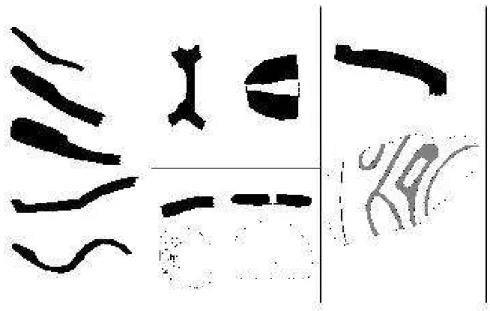
ent (Figure 4B). The lips are rounded and thickened or tapered. Some frag-ments of flat-based vessels were re-covered (Figure 4C). Little can be said about the surface treatment of the pottery, since the sherds are eroded. The common decorative techniques are incision (Figure 4A) and fine-line incision, in addition to some sherds
with short parallel rim-nicking and fin-gernail incisions. Two small unnotched stone axes and a cylindrical grinding stone were also recovered at the site. An interesting fragment of an anthro-pomorphic vessel was recovered by a resident of Tumichucua near ditch B connecting the oxbow lake with the Beni floodplain, at some 200 m dis-tance from the lake. It represents a hu-man face with coffee bean-shaped eyes (Figure 5). The reddish-yellow ware has ground sherd temper. The frag-ment in question resembles the mod-eled anthropomorphic effigies typical of the Barrancoid Tradition (Lathrap 1970:168). Stylistically similar anthro-pomorphic vessels have also been re-ported from the Upper Beni River, in the proximity of the Andean piedmon-te (Nordenskiöld 1924, Portugal 1978).
ESTANCIA GIRASOL
Figure 5 - Fragment of an anthropomor-phic vessel recovered at the Tumichucua site. Photo S. Saunaluoma.
total length.
We excavated three 1 m x 1 m test units during the 2005 field season. Unit 1, 70 m to the north of the eroded double ditch, and Unit 3 placed in between these ditches yielded a few eroded pot-sherds in the 0.1-0.5-m-levels, while Unit 2, excavated in the bottom of the outermost ditch, suggested ceramic ac-cumulation in the levels 0.2-0.7-m. The Estancia Girasol pottery is dete-riorated, and only five precent of the
sherds are diagnostic. The few recov-ered rim sherds represent globular or straight body forms with out-turned tapered or rounded lips (Figure 4D). The only basal sherd is flat. The ware is coarse, mainly cariapé tempered, but sand, carbon, and ground sherd tem-pers also occur.
ESTANCIA MENDEZ
The Estancia Mendez site is located 12 km to the southwest of Tumi-chucua. This earthwork site consists of two simple ditches oriented in N-S-direction, beginning on the bluff of the Beni River and disappearing at some distance from the floodplain. The westernmost ditch is 16 m wide and, in part, almost 1.8 m deep. A frag-ment of caraipé tempered pottery with
Figure 6 - Earthworks and location of test units excavated in 2001-2005 at the Estan-cia Girasol, Las Palmeras, EstanEstan-cia Giese, and El Círculo sites.
a pedestal base was found in a cut of a dirt road which crosses the ditch. The other, less prominent ditch is 12 m wide. The distance between these two ditches is approximately one hundred meters and probably they associated in the same earthwork complex, although the full dimensions and shape of these earthworks remain unknown.
CHACRA CARBAJAL
An earthwork is located approximately 5 km to the southwest of the com-munity of Candelaria and 1.5 km to the east of the Madre de Dios River. This site includes a shallow U-shaped ditch that surrounds a natural hill cov-ered with thick secondary vegetation. The ditch ends in an old river channel, and the open side of the U-shaped earthwork faces in direction of the wa-tercourse. We did not find any other
archaeological remains while briefly exploring the course of the earthwork, but without doubt, a more careful sur-vey would reveal more information on the site.
LAS PALMERAS
The community of Las Palmeras is situated 7 km to the northeast of Ri-beralta. Today the distance to the Beni floodplain is about 5 km. The Las Palmeras site was located in 1998 by Ari Siiriäinen and Jorge Arellano. Arel-lano carried out test excavations at the site the following year, acquiring pot-tery which he classified into six distinct types (Arellano 2002:58-65).
The earthwork of Las Palmeras is a roughly circular ditch, approximately 12-m-wide, 1-m-deep, and 270 m in diameter (Figure 5). According to the landowner, the ditch was more promi-nent when he purchased the property in the 1970s. The Las Palmeras earth-work has suffered considerably from modern-day land use, making the course of the ditch difficult to distin-guish in certain places. The dirt road crossing the structure has all but
stroyed the southernmost part of the earthwork. In the western part of the site, small mounds, approximately 2 m x 3 m in size, were observed inside the circular ditch. Recent agricultural activ-ities had exposed numerous potsherds that were scattered on the surface of the mounds.
In 2001, we excavated Trench 1 (1.5 m x 2.5 m) on the northern side of one of the small mounds, cutting the feature into two halves (Figure 7). While excavating, we noticed that the mounds were actually formed by the backfill coming from oval-shaped de-pressions measuring approximately two square meters and situated adja-cent to the mounds. The thickness of the cultural layer which lay underneath a thin humus layer was only 0.1 m on top of the mound, but reached down to a depth of 1.3 m on the side of the depression. Most of the pottery (64%) was concentrated in the depression, in the levels 0.1-0.3 m. The number of potsherds decreased gradually in the next three levels, but increased again in the 0.6-0.7-m-level, which was also the last level to contain pottery. Immedi-ately underneath, in the 0.75-m-level, we observed a 0.15-m-thick feature consisting of a powdered substance in the dark brown cultural soil. A sample of this substance was later analyzed, revealing it to be calcite3.
Trench 2 (0.5 m x 2 m) was placed on another mound, located some 20 m to the southwest of the Trench 1. The thickness of the dark brown cul-tural layer was some 0.2 m on top of the mound and almost 1.3 m on the
bottom of a depression on the north-ern side of the mound. The majority of the potsherds were collected from the excavation levels 0.0-0.1 m (34%) and 0.3-0.4 m (35%). Pottery was ab-sent from the levels 0.4-0.6 m, but we obtained the last few sherds from the 0.6–0.7-m-level.
Two 1 m x 1 m test units suggested that the thickness of the cultural layer reaches down to a depth of 0.4 m in-side the circular ditch in the proxim-ity of the above-mentioned mounds. Unit 4, situated 10 m outside the ditch, revealed a cultural layer of a similar thickness, but soil in Unit 5 placed 50 m to the east of the earthwork was cul-turally sterile. Unit 3, excavated in the bottom of the ditch on the northern side of the site, exposed a midden de-posit: dark-colored culturally altered soil containing a considerable amount of charred organic matter and ceram-ics (303 potsherds), which begun at the 0.2-m-level and continued to a depth of 1.2 m.
Figure 8 - Las Palmeras assemblage, in-cised rim (diameter 28 cm) from Unit 3 and below incised rim (diameter 20 cm) from Trench 1, drawn to the same scale.
and poorer in quality. Rims are everted, inverted or direct (Figures 8 and 9E). Lips are tapered, rounded and thick-ened or out-turned and squared. Some fragmentary handles and flat bases are also present in the assemblage. The main aspects of the ceramics are simi-lar, regardless of the two separated oc-cupation phases indicated by the 14C
dates (discussed below).
ESTANCIA GIESE
The ranch of Roger Giese is situated 6 km to the northeast of Riberalta and 2 km to the north of the Las Palmeras site. An embankment found on the ranch is eroded due to cane sugar cul-tivation and earlier cattle farming. The semicircular part of the embankment
Figure 9 - A-C: Estancia Giese assemblage, incised rims (diameter 18 cm) and fine-line incised rim (diameter 12 cm), D-F: Las Palmeras assemblage, fingernail-incised rim, inverted rim, and globular incised body. The length of the incised body sherd (F) is 10 cm, all fragments drawn to the same scale.
While laying the foundations for a hen house in the early 1990s, the proprietor found a small polished stone axe with side notches at a depth of some 0.2 m below ground level. In 2001, we exca-vated a 1 m x 1 m test unit near the spot at which the axe had been found, 30 m to the east of the embankment. This unit suggested that the cultural material was sparse, only a few erod-ed potsherds were observerod-ed in the 0.2-0.4-m-level.
In 2002, a six additional 1 m x 1 m test units were excavated at the site to study the extension of the occupational area located in 2001. Unit 1 was placed on top of the embankment and revealed only one potsherd at a depth of 0.6 m. The uppermost layer (0.0-0.3 m) exca-vated consisted of soil mixed with matite fragments. This deposit of he-matite was observed on the surface of the embankment of the entire north-ern part of the earthwork. The upper levels of Unit 2, excavated 20 m to the south of the embankment, had been disturbed by cane sugar cultivation. Three potsherds were recovered, again in the 0.6-m-level. In Units 3-5, placed 20 m, 40 m, and 100 m to north of the Unit 1, evidence of cultural mate-rial was scarse, only minor concentra-tions of potsherds in the levels 0.2-0.4 m. Unit 6, located near the base of the embankment on the western side of the site, contained a cultural layer asso-ciated with an accumulation of ceram-ics and organic material, charcoal, and carbonized seeds at depths of 0.4-0.8 m. The ceramics recovered at the Estancia Giese site are fragmented and
deterio-rated, and only 10% of the shreds are diagnostic. The general characteristics of the pottery are predominant use of cariapé temper, hematite temper in lesser quantity, incised and fine-line incised decoration, direct rims in finer ware (Figure 9A-C), and out-turned thickened lips in the utility ware. The few recovered basal fragments are from flat-bottomed vessels.
EL CÍRCULO
ditch begins on the old bluff of the Beni floodplain, runs 380 m to the north, and then turns and continues some 140 m to the northeast, vanish-ing gradually. The ditch has a depth of 0.5-1 m, and is accompanied by a low embankment formed of the ditch backfill on the eastern side.
In 2001, we excavated five 1 m x 1 m test units at the site. Unit 1 was placed on one of the westernmost mounds attached to the embankment. The cultural layer began at a depth of 0.2 m, where the first few potsherds and dark colored soil were observed. The 0.4-0.6-m-level yielded a similar amount of pottery, but the soil con-tained more charcoal and burnt clay. The 0.6-0.8-m-level was associated with a hearth feature, consisting of a 0.1-m-thick crust of burnt clay beneath which a concentration of carbonized wood on top of another 0.1-m-thick layer mixed with burned clay and soot was observed. The base of the cul-tural deposit (0.8-1.0 m) contained an accumulation of pottery (48% of the sherds recovered from this unit). Some fragments of resin were also found in the cultural strata. Unit 2, situated on a smaller mound 80 m to the northeast of the Unit 1, suggested an even dis-tribution of ceramics throughout the cultural deposit. Potsherds were found between the 0.2 and 0.6 m levels. The 0.3-0.4-m-level had an accumulation of fragments of burnt clay and char-coal in a sooty soil. Units 3-5 excavated in other parts of the site at some dis-tance from the embankment turned out to be culturally sterile.
During the 2003 field season, more comprehensive excavations were car-ried out at the site to define the lim-its and extent of the cultural strata. Nineteen 0.6 m x 0.6 m test units were excavated at 25 m intervals along an E-W-line transecting the site beginning from the western side of the circular embankment and ending at the ditch situated to the east of the site. Three additional test units were excavated at the ends of the ditch, and one test unit
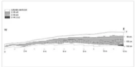
Figure 10 - El Círculo, profile of the trench excavated in 2003.
was placed 20 m to the north of the entrance of the circular embankment. None of these units contained archae-ological material.
at 1.5 m in the eastern end (Unit 12), on top of the mound (Figure 10). Underneath a thin humus layer, we encountered a culturally sterile light reddish-brown soil. The thickness of this layer was 0.15 m in the west-ern end of the trench and 0.40 m on top of the mound. Below this sterile layer, we observed a 0.15-0.45-m-thick yellowish-red (5 YR 4/6) stratum. In the 0.6-1.3-m-levels, from Unit 5 to the eastern end of the trench, a red-dish-brown (5 YR 4/4) layer was en-countered. This layer mixed with the yellowish-red one in Units 7, 11, and 12. Both layers contained accumula-tions of potsherds and fragments of burnt clay as well as organic material, such as carbonized seeds. In Unit 12, at a depth of 1.3 m, we encountered a thin dark reddish-brown (5 YR 2.5/2) layer mixed with charcoal reaching to a depth of 1.45 m.
In Units 4 and 5, the 0.4-0.5-m-level consisted of a hearth feature with a concentration of charcoal and burnt clay. Another hearth was found in Unit 8, level 0.7-0.8 m. Unit 6 yielded one third of an undecorated ceramic vessel which had remains of organic material and carbonized seeds inside. A total of 658 sherds (19 kg) were obtained from the trench excavation, most of which (53%) were found in Units 6-8. The major accumulation of pottery was in the levels 0.5-0.8 m.
The ceramics of the El Círculo site differ from the other ceramic assem-blages of the Riberalta region. Twelve percent of the sherds are diagnostic. The ware is caraipé tempered, and
incised decoration is sparse, although several fingernail-incised sherds (Fig-ure 11B) were recovered. Traces of a dark brown as well as red all-over slip and red painting on white slip are still observable on several sherds (Figure 11F). Rims are direct or everted with squared or rounded and thickened lips (Figure 11A). Flat basal fragments as well as pedestal bases (Figure 11C) are present, as are spindle whorls (Figure 11D-E). Reconstructed vessels bod-ies are globular in shape, and open-mouthed bowls are also present in the assemblage. Some fragments of grind-ing stones made of laterite slabs and small fragments of resin4 were also
re-covered. Surface collection at the site yielded a re-utilized polished stone axe.
CHACRA TELERÍA
The Chacra Telería site is located about 3 km to the northwest of the El Círcu-lo site and the present-day Beni fCírcu-lood- flood-plain. The proprietor of the land had noticed abundant potsherds scattered on the surface of his field, but he was unaware of any earthworks related to these finds. To clarify the chronology and variation of the cultural material of this site in relation to the earthwork sites of the region, a surface collection of the diagnostic pottery was made, and a 1 m x 1 m test unit was excavated during the 2005 field season. The test unit exposed a cultural layer at a depth of 0.2-0.5 m associated with abundant ceramics.
Figure 11 - El Círculo assemblage, A: rims (diameters 18-21 cm), B: fingernail-incised rim, C: pedestal base, D-E: spindle whorls, F: painted rim (diameter 14 cm). The diameter of the discoidal spindle-whorl (D) is 4,5 cm, all fragments drawn to the same scale.
are diagnostic. The ware is caraipé, sherd, and sand tempered. Rims are everted, but also some direct rims are present. Lips are rounded and thick-ened, and the base sherds are flat. Rim diameters vary between 10 cm and 20 cm in decorated pottery, and larger un-decorated rimsherds have a diameter up to 40 cm. The few defined vessel forms represent globular and round bodies. Frequently used decoration techniques are incision and fine-line incision (Figure 4E-G). Dark brown all-over slip occurs on some sherds.
CANDELARIA
Adjacent to the bluff of the Madre de Dios River, near the small community of Candelaria, local inhabitans had lo-cated abundant potsherds, including a small pedestal base, scattered on the
DOS PALMAS
Dos Palmas, a small community of ca. 100 inhabitants, is situated 5 km to the southwest of the community of Can-delaria. A brief surface collection car-ried out during the 2005 field season in a manioc field yielded few undiag-nostic potsherds and a sandstone flake. The Dos Palmas site does not have any earthworks.
ESTANCIA VELASCO
Halfway between Tumichucua and Es-tancia Girasol, we noticed archaeologi-cal remains on a stream bank. A sur-face collection at the site yielded some fragmented grinding stones made of laterite slabs, a fragment of an abraded stone artifact, a fragment of a pottery vessel base, as well as some fragments of fine-grained ware with caraipé tem-per. This site has no visible earthworks.
CERAMIC TRADITIONS OF THE SOUTHWEST AMAZON
Information about the ceramic se-quences of the Southwest Amazon is scarce. So far, the most completely documented are those of the River Ucayali Basin (De Boer 1972, Lathrap 1970, Myers 2002, Roe 1973, Weber 1975). Tutishcainyo, the earliest ceram-ic style recognized in the region, was replaced around 300 B.C. by Hupa-Iya modeled-incised style pottery, whose introduction is interpreted as result-ing from Arawakan migration into the area (Lathrap et al. 1985:46-47). Ap-proximately A.D. 90, Yarinacocha, a
new tradition of robust, almost non-decorated ceramics, interpreted as hav-ing had its roots in the Central Ama-zonian Polychrome Tradition, arrived in the region (Lathrap et al. 1985:47). The period A.D. 300-800 corresponds to the arrival and dominance of the Panoans along the Ucayali River. They brought with them the Pacacocha Tra-dition of technologically simple ce-ramics, featuring all-over red slip, zoo-morphic adornos, corrugation, everted rims, and globular forms (Lathrap et al. 1985:47-48). The hallmarks of the subsequent tradition, Cumancaya (A.D. 800-1250), include corrugated, fine-line incised, and brushed decora-tion, as well as use of caraipé temper (Myers 2002:76). The appearance of the region’s last recognized prehistoric ceramic tradition dates to around A.D. 1200, when Tupi-speaking groups, producers of highly elaborated poly-chrome ceramics, invaded the flood-plains of the Ucayali River (Lathrap et al. 1985:91).
slip and red lines on white slip used as the predominant decorative technique. Incised potsherds are also found, but in lesser quantities. Typical of the Qui-nari tradition is an anthropomorphic vessel in the form of a cylinder on a globe, representing a human face in which the design is executed using the appliqué technique.
The common traits of the ceramic se-quences of the Central Llanos de Mo-jos are: the use of ground sherd, shell, and cauxi temper, incised-modeled, incised, and polychrome painted deco-ration, globular tripode and tetrapode vessels, and pedestal bases as well as large discoidal plates and grater plates (Calandra & Salceda 2004:159, Dough-erty & Calandra 1981, Jaimes 2009). In addition, pottery related to the Barran-coid Tradition and the Central Amazo-nian Polychrome Tradition has been recovered at some mound settlements (Lathrap 1970:124-125,159, Norden-skiöld 1913). The mound settlements have been dated to around the time span A.D. 350-1300 (Dougherty & Calandra 1982) and A.D. 600-1400 (Jaimes 2009). The late pre-Columbi-an ceramics from the Baures region, in northeastern Llanos de Mojos, are mainly cauxi, kaolin, or ground sherd tempered and fine-line incised. Figu-rines, appliqué technique, supports, and painting are also present, but to a lesser extent. (Dougherty & Calandra 1985:50, Prümers et al. 2006:274-279). Some fragments of flat bottomed vessels with impressions from palm fiber basketry were recovered in the Bella Vista complex (Prümers et al.
2006:280).
The ceramic traditions of the northern Bolivian lowlands are poorly known. The fragmentary pottery collected at sites with earthworks along the Or-thon River is generally tempered with caraipé, hematite, ground sherds, and shell. The few defined vessel forms are globular in shape with everted rims. Additionally, the use of all-over slip, in-cision, and excision has been reported (Arellano 2002). The Finnish-Bolivian excavations at the La Fortaleza de Las Piedras site yielded a handful of Inca-style ceramics, a much larger quantity of typical regional caraipé and sand tempered utility ware, a few sherds of painted and incised pottery, as well as larger fragments of more sophisti-cated pottery, most likely ceremonial bowls, decorated with incised geomet-ric designs and bearing some common features with the Sivia-style pottery of the Upper Amazon of Peru (Siiriäinen et al. 2002; Korpisaari et al. 2003).
CERAMIC STYLES OF THE RIBERAL-TA REGION
dis-play some common traits typical of Amazonian ceramics, such as caraipé and ground sherd temper, incision, fine-line incision, all-over slip and, to a lesser extent, fingernail incision, while the most distinctive attributes of the Incised-Punctated and the Amazonian Polychrome Tradition are lacking. The El Círculo ceramics dif-fer from other assemblages in having painted ware, mainly red designs on white slip, open-mouthed-bowls, and spindle whorls. Otherwise, the stylistic differences among the ceramics of the investigated sites are slight, regardless of the chronological dispersion. The Riberalta ceramic assemblages can be considered as regional styles which have some features typical of late pre-historic ceramic traditions of the Up-per Purus River Basin and the Ucayali River Basin, although the corrugation occurring in the Pacacocha and Cu-mancaya traditions is not present. Arnold and Prettol (1988:462) men-tion that Tumichucua pottery is com-parable to the Curralinho ceramic complex of the lower Madeira River, while Thomas Myers (1988:76) finds it related to Miracanguera, a subtradi-tion of the late prehistoric Amazonian Polychrome Tradition. However, our dates of the Tumichucua site (72 ± 81 cal. B.C. and cal. A.D. 98 ± 43) do not support these inferences. The Cur-ralinho complex, which pertains to the Incised-Punctated Tradition, has three dates: A.D. 840 ± 60, A.D. 885 ± 90, and A.D. 1451 ± 55 (Simoes & Lopes 1987:122). Furthermore, the spread of the Amazonian Polychrome Tradition
upstream from the Central Amazon occurred only after A.D. 900, and pos-sibly influenced the ceramic complexes of the Bolivian tropical savanna low-lands around A.D. 1000 (Brochado 1984:329-330). Curralinho pottery is also characterized as predominantly having caraipé temper (Simoes & Lopes 1987), which is rare in Tumi-chucua pottery.
INTERPRETATIONS AND CHRONOL-OGY OF AMAZONIAN EARTH-WORKS
been considered advantageous dur-ing the Amazonian late prehistory which is often described as a period of intensifying waves of migration and ethnic expansion, accomplished by Tupi-Guarani groups (Brochado 1984; Heckenberger 1996; Lathrap 1970:78-79; Lathrap et al. 1985:91-94; Pärssin-en et al. 2003; Wüst & Barreto 1999:6). Moreover, the Pano-speaking groups have a lengthy history of conflicts with the neighboring ethnic groups, as well as of constant endo-warfare (Santos-Granero 2002:29). Villages surrounded by moats and palisades in the eastern lowlands of Bolivia are reported in the ethnographic record (Denevan 1966; Erickson et al. 2008; Metraux 1948:82; Nordenskiöld 1918), so the building of protective palisades may have been practiced also in pre-Columbian times, at least during the late prehistoric pe-riod.
The ring-ditch sites of the savannas of the Baures region may have enclosed settlements, or been constructed for defense, elite residences, cemeteries, ritual spaces, and/or special gardens (Erickson 2006:259, Erickson et al. 2008, Prümers et al. 2006). Some of the more complex earthwork sites found in the State of Acre possibly served as ceremonial centers or meet-ing places (Pärssinen et al. 2009) – or both – and would thus be related to the cosmology and socio-political concerns of the peoples that occupied them. The repetitive pattern of precise geometric forms of the earthworks, carefully planned and constructed, and the way in which these constructions
are situated in the landscape, suggest ritual functions that were part of a tra-dition of shared collective perception and ideology.
While some ditches reserve water dur-ing the rainy season, Martti Pärssinen and colleagues (2003:101,130) sug-gested that the ditches of the State of Acre could have also been used for aquaculture, as ethnographic literature mentions the raising of small fishes, molluscs, and turtles in artificial aquat-ic depressions near the indigenous vil-lages.
Acre, in the Purus Basin, have yielded thermoluminescence dates of approxi-mately 1200-0 B.C. and 200 B.C.-A.D. 200, respectively (Nícoli 2000:131). These published dates reveal that the Amazonian earthwork engineering is a cultural tradition covering an extended period.
DATING OF THE INVESTIGATED SITES
One of the principal goals of our re-search in the Riberalta region was to collect radiocarbon samples from se-cure archaeological contexts. So far, 18 samples from seven sites have been dated (Table 2).
Tumichucua and Chacra Telería sites represent the earliest occupation of the sites discussed here, dating from the first century B.C. to the first century A.D. At the Las Palmeras site, we dated two different components of the site: one of the small mound/depression features situated inside the ditch and the cultural layer in the circular ditch at a depth of 0.6 m. The sample collected from cultural soil located directly be-low the calcite feature in Tench 1 is late (cal A.D. 1582 ± 57). In contrast, the date obtained from the ditch, is much earlier (cal A.D. 159 ± 51). Thus, the mounds/depressions correspond to a later phase of human activity at the site. Based on the moderate depth (0.4 m) of the cultural layer inside the area demarcated by the ditch, the occupa-tion of the site was not continuous. Perhaps the abandoned site was cho-sen to be re-occupied in a later phase
precisely because of the presence of the existing earthwork.
The radiocarbon dates5 recovered at
the Estancia Giese earthwork site (cal A.D. 194 ± 54 and cal A.D. 330 ± 57) indicate that the initial stage of the use of this site was roughly coincident with Las Palmeras’ first occupation phase. The Candelaria site, situated adjacent to the floodplain of the Madre de Dios River, dates to cal A.D. 327 ± 56, and is contemporaneous with the later date of occupation of the Estancia Giese site. Based on a single date, the Estan-cia Girasol site seems to be much more recent (cal A.D. 1428 ± 13).
In total, we have eight radiocarbon dates from the El Círculo site. The
14C dates indicate that the occupation
of the site lasted for slightly over one hundred years (from cal A.D. 1272 ± 11 to cal A.D. 1349 ± 44)6. It is
Site Unit, Level
Context Lab id C14-age bp Calibrated date
Tumichucua 2002 Unit 1, - 40 cm
Charcoal in cultural layer
Hela-702 1905 ± 40 Cal 98 ± 43 AD Tumichucua 2005 Unit 6,
- 60 cm
Charcoal in cultural layer
Ua-24932 2045 ± 65 Cal 72 ± 81 BC Estancia Girasol
2005
Unit 1, - 40 cm
Charcoal in cultural layer
Ua-24929 475 ± 35 Cal 1428 ± 13 AD Las Palmeras 2001 Trench 1, -96 cm Charcoal in cultural layer
Ua-24076 285 ± 35 Cal 1582 ± 57 AD Las Palmeras
2005
Unit 3, - 60 cm
Charcoal in cultural layer
Ua-24930 1850 ± 40 Cal 159 ± 51 AD Estancia Giese
2002
Unit 4, - 40 cm
Charcoal in cultural layer
Hela-708 1815 ± 45 Cal 194 ± 54 AD Estancia Giese
2002
Unit 6, - 60 cm
Charcoal in cultural layer
Hela-709 1695 ± 40 Cal 330 ± 57 AD Estancia Giese
2002
Unt 1, - 80 cm
Charcoal under cultural layer
Hela-707 10355 ± 80 Cal 10318 ± 211 BC El Círculo
2001
Unit 2, 50 - 60 cm
Ceramic tem-per
Hela-570 1790 ± 75 Cal 233 ± 93 AD El Círculo
2001
Unit 1, - 85 cm
Hearth Hel-4585 600 ± 60 Cal 1349 ± 44 AD El Círculo
2003
Unit 7, - 20 cm
Charcoal in cultural layer
Poz-9523 680 ± 30 Cal 1326 ± 45 AD El Círculo
2003
Unit 7, 40 - 50 cm
Soot on sherd surface
Poz-9426 715 ± 30 Cal 1272 ± 11 AD El Círculo
2003
Unit 6, - 53 cm
Charcoal under a ceramic vessel
Poz-9524 650 ± 30 Cal 1334 ± 41 AD El Círculo
2003
Unit 8, - 80 cm
Hearth Poz-9427 660 ± 30 Cal 1331 ± 42 AD El Círculo
2003
Unit 10, 100 - 110 cm
Carbonized seed in cultural layer
Poz-9428 685 ± 30 Cal 1324 ± 46 AD
Table 2
period of European contact7. What,
then, happened before and between these two periods? Assuming that the settlement pattern was preferably riv-erine and bearing in mind the active meandering on the floodplains of the Beni and Madre de Dios Rivers, many archaeological sites today may today be located far from the active river chan-nels, and some have been destroyed by the relocations of the watercourses. The present survey found a few of the possibly hundreds of archaeological sites in the region. Therefore, the ini-tial stage of human occupation could have begun centuries, or even millen-nia earlier, and the region may have been inhabited more or less continu-osly with settlement locations along navigable water routes.
EARTHWORK FUNCTIONS AND SETTLEMENT LAYOUT
I argue that the primary purpose of simple, individual earthworks, such as those of the Riberalta region, was to visibly delimit and mark the area of occupation. In some cases the earth-work enclosure could have been more symbolic than practical. Based on the test excavations, the archaeologi-cal deposits seem to be concentrated
El Círculo 2003
Unit 10, 120 - 130 cm
Soot on sherd surface
Poz-9429 645 ± 30 Cal 1335 ± 40 AD Chacra Teleria
2005
Unit 1, - 42 cm
Charcoal in cultural layer
Ua-24931 1940 ± 40 Cal 57 ± 44 AD Candelaria
2005
Unit 1, - 25 cm
Charcoal in cultural layer
Ua-24928 1700 ± 40 Cal 327 ± 56 AD
mainly inside the area delineated by the earthworks in the Tumichucua, cia Girasol, Las Palmeras and Estan-cia Giese sites. Moreover, the ditches contained quantities of cultural debris. The moderate depth of the archaeo-logical deposits and lack of marked stratigraphy did not indicate centuries-long uninterrupted occupation at the investigated earthwork sites. The occu-pation persisted for a few generations, or the use of the sites was more spo-radic than continuous.
By building enclosures, people may have wanted to protect themselves from the natural and supernatural worlds, too. The vast rainforest encir-cling the villages was not completely tamed, although the prehistoric in-habitants of Amazonia were certainly acquainted with their environment. Many activities occurred in the village at night when darkness transformed the surrounding rainforest into a place more mysterious and dangerous than in daylight. Even today, the forest is home to many inexplicable entities and supernatural beings or spirits such as
communities needs to be grounded in archaeological data, but one can imagine the multitude of mythical creatures, some benevolent, some evil, which formed part of the universe of the past Amazonian peoples.
Some of the ditches can be interpret-ed as evidence of water management. Ditch B at the Tumichucua site may have served as a canal facilitating ac-cess between the oxbow lake, the river, and the floodplain (Arnold & Prettol 1988:463). The Estancia Girasol and El Círculo sites also have simple ditch-es which pass within several hundred meters of the occupation sectors and could have been used as canals to link smaller streams with more primary wa-tercourses.
In addition, the ditch at the Las Palm-eras site apparently served as a dump for domestic waste, judging by the in-tensely dark color of the cultural layer found on its bottom. This charcoal rich cultural layer was different from that found inside the earthwork. At Tumichucua we also found fragments of pottery and charcoal in the circular Ditch D, which was also observed by Arnold and Prettol (1988:461), as in the outer double-ditch of the Estancia Girasol site. Still, the possible utiliza-tion of these earthworks in the dispos-al of refuse should not be considered as one of their central functions, but rather as one of the secondary ways in which the ditches situated in the prox-imity of the settlements could have been used. Furthermore, if the earth-work sites were later re-occupied, as seems to have been the case with the
by roads, forming a complex entity of clusters of occupational sites, which is not the case of the earthwork sites of the Riberalta region.
In regard to the settlement plan, the El Círculo site was apparently differ-ent from the other sites studied in the region. I interpret the El Círculo mounds as the remains of residences because our excavations revealed in-tense concentrations of ceramic and domestic debris (Figure 10), including hearth features, in the mounds form-ing part of the embankment. The circular occupation zone for domes-tic activities encloses an area which was presumably kept clean as a plaza since the test units excavated inside this zone contained no archaeologi-cal remains. The earthwork type and the settlement plan, together with the presence of a distinct pottery style contrast with the other pre-Columbian sites found so far in the region of Ri-beralta, suggesting that the occupants of the El Círculo site may have had a different ethno-cultural background8.
The settlement form and size (350 m in diameter) of the El Círculo site resemble the ring villages of Central Brazil in which a circular, elliptical, or semicircular arrangement of houses enclose the central plaza (Wüst & Bar-reto 1999). The ring villages prevailed around A.D. 800-1700 and are associ-ated with the Aratu and Uru ceramic traditions (op. cit.). The circular plaza was the public, communal sector of the village, reserved for certain gath-erings, festivities, rites, and ceremonial displays. The habit of considering the
central plaza as the political and ritual center of the village can still be seen in the Upper Xingu area among the present-day Kayapó (Turner 2002) and Kuikuro, of which the last-mentioned group may be preserving the cultural characteristics of their ancestors, al-though the size of the villages today is much smaller (Heckenberger et al. 2008:1215). The circular village plan linked with socioceremonial organiza-tion is also common among the con-temporary Gê and Bororo groups of Central Brazil (Nimuendajú 1946:37, Wüst & Barreto 1999:3-4).
closer to a triburitary or main channel when occupied in the distant past.
DISCUSSION
Construction and use of earthworks was not restricted to certain prehistoric periods or areas of the South Ameri-can tropical lowlands. The earthwork tradition manifests itself in slightly dif-ferent ways at difdif-ferent times in a num-ber of regions, determined by natural and cultural factors. Clark Erickson (2006) argues that the monumental earthworks of the seasonally inun-dated savanna plains of the Bolivian Amazon are domesticated landscapes shaped by a long, complex history of past human activities, a profound pro-cess that was driven by social demands. Thus, the reasons for constructing the earthworks were not only practical, but also aesthetic, ideological, social and political. The earthworks were planned and constructed intentionally, with the purpose of altering the environment permanently and visually. Simultane-ously, the domination and manipula-tion of the landscape were symbols of territoriality, demonstrating to others any given group’s ability and right to occupy a given territory. These activi-ties left important signatures embed-ded in the landscape – traces which remain long after the sites were aban-doned and the groups that carried out the landscape engineering moved away or ceased to exist.
Cultural traditions and ethnicity are not necessarily related (Lucy 2005). The characteristics of material culture
are easily transferred from one ethnic group to another, which can be seen, for example, among the modern-day Piro who belong to the Maipuran-Arawakan linguistic group but whose ceramic decorative/artistic tradition is Panoan, typical of the Shipibo-Conibo (Lathrap et al. 1985:33). However, the connection between certain ceramic traditions and ethno-linguistic families is appealing. Donald Lathrap and col-leagues (1985) and Myers (2002:105) propose that analogues of the Pacaco-cha (Panoan) ceramics of the Ucayali are to be found in the tropical lowlands of Bolivia, and that a continuous long-term stream of people moved from the Eastern Bolivian Panoan heartland towards the floodplains of the Peru-vian Amazon. Lathrap (1970:81) also describes the interfluvial ecological dispersal typical of Panoan groups, ex-tending across the upper watersheds of the Madre de Dios, Purus, Juruá, and Ucayali Rivers. Taking into account the incised, fine-line incised and fingernail impressed ceramic styles found at the Riberalta sites, the hypothesis of the Panoan connection requires careful consideration.
be studied before any conclusions of the ethnicity and/or socioceremonial aspects of the El Círculo inhabitants can be drawn.
The earthworks in the Riberalta re-gion have a variety of forms and are found in slightly different locations, indicating separate time periods, pos-sibly distinct cultural affiliations, and obviously diverse functions. Although only a small number of the possible pre-Columbian sites of the Riberalta region were recorded during the pres-ent study, we found differpres-ent types of sites indicating fairly dense occupa-tion, but lacking long permanence in the same location. The earthwork tra-dition prevailed in the Riberalta region from at least 100 B.C. until the period of European contact. Compared to the variable layout of the sites, the ce-ramic assemblages of the region are relatively homogeneous. Except for the El Círculo assemblage, which has a small number of incised sherds and painted sherds in abundance, a uni-form ceramic style prevailed in the Ri-beralta region througout the late pre-Columbian period. The environmental conditions alone apparently did not in-fluence the position of the earthworks, as some sites are situated on the river bluffs and others at some distance from the navegable river channels. The earthworks of the Riberalta region are less complex and diverse than the ones registered in the State of Acre and Central Llanos de Mojos. The func-tions of the structures may have been simply to enclose the occupation areas and, in some cases, to serve as canals.
We also recorded sites without earth-works that are contemporaneous with the earthwork sites. One objective for future research would be to determine if these two types of sites are associ-ated with each other, being used by the same people but for different purpos-es, if the sites were hierarchically relat-ed, and if the earthwork sites correlate with a single or multiple cultural and/ or ethnic traditions.
ACKNOWLEDGEMENTS
Marupa, Ciro Rossell, and Ricardo Ya-mara of the Tumichucua community, and Hugo Vargas of the community of Puerto Rico.
The author’s first acquaintance with the archaeological sites of the Bolivian Amazon was in 1997 during a prelimi-nary excursion to Riberalta that was re-alized under the auspices of the proj-ect “Prehistory of the Chiriguano and Tacano”. The fieldwork seasons 2001-2003 formed part of the “The Ama-zonian Interests of the Incas” project. Both projects were funded by the Uni-versity of Helsinki and coordinated by Ari Siiriäinen. The investigations carried out in 2005 formed part of the multidisciplinary research project “Man and Nature in Western Amazo-nian History” of the University of Hel-sinki, Universidade Federal do Acre, and Museo Paraense Emilío Goeldi, financed by the Academy of Finland and coordinated by Martti Pärssinen and Denise Schaan. While putting the finishing touches on this article, I was supported by a Kone Foundation re-search grant. The Ella and Georg Eh-rnrooth Foundation provided funds for processing the radiocarbon samples of the El Círculo site.
NOTES
1 By Southwest Amazon, I refer to the
re-gion defined by the triburitary areas of the rivers Ucayali, Juruá, Purus and the white-water triburitaries of the Madeira River, flowing in the alluvial extension zone of the Amazon Basin.
2 For the detailed bibliography, historical
context, and description of the La For-taleza de las Piedras site, see Siiriäinen and Pärssinen 2001:64-70.
3 The X-ray diffraction analysis of this
sample was carried out on March 10, 2005 in the University of Helsinki.
4 The contemporary Cavineño use resin
to glaze their pottery (Plaza & Carvajal 1985:70).
5 The third date (10355 ± 80 B.P.) from the
Estancia Giese site is a clear outlier. The 14C sample was collected below the cultur-al deposit with the objective of dating the initial establishment of the embankment. Unfortunately, this charcoal sample turned out to actually date some ancient natural burn event.
6 One date (cal A.D. 233 ± 93) is an
excep-tion. The material dated was organic tem-per from a non-diagnostic potsherd. The sample was collected in 2001 from test unit 2 at a depth of 0.6 m, which was the last level containing ceramics. I consider that this potsherd does not belong to the actual earthwork but rather is an evidence of an earlier occupation in the same area, taking into account that the Chacra Telería site, situated 3 km from the El Círculo site, dates to more or less the same period (cal A.D. 57 ± 44).
7 The La Fortaleza de Las Piedras site was
possibly occupied until A.D. 1600 (Siiriäin-en 2003).
8 Corresponding earthworks have been
circle, as well as a simple ditch in the prox-imity of the mounds. Both sites yielded surface ceramics which bear some resem-blance to El Círculo pottery (Schaan & Bueno 2008:37, 78).
REFERENCES
Arellano, J. 2002. Reconocimiento arqueológico en la cuenca del rio Orthon, Amazonia Boliviana. Quito: Museo Jacinto Jijon y Caamaño/ Taraxacum.
Arnold, D. & K..Pret¬tol. 1988. Aborigi-nal earthworks near the mouth of the Beni, Bolivia. Journal of Field Archaeology
15(4):457-465.
Balée, W. & C. Erickson (eds). 2006. Time and complexity in historical ecology. Studies in
neotropical lowlands. New York: Colombia
University Press.
Brochado, J. 1984. An ecological model of the spread of pottery and agriculture into Eastern South America. Ph.D. Diss., University of Il-linois at Urbana-Champaign.
Calandra, H. & S. Salceda. 2004. Amazo-nia boliviana: arqueología de los Llanos de Mojos. Acta Amazonica 34 (2):155-163. DeBoer, W. 1972. Archaeological explo-rations on the Upper Ucayali River, Peru. Ph.D. Diss., Department of Anthropol-ogy, University of California at Berkeley. ____. 1966. The aboriginal cultural geography of the Llanos de Mojos of Bolivia. Berkeley: University of California Press.
____. 1996. A bluff model of riverine settlement in prehistoric Amazonia. An-nals of the Association of American Geographers
86(4):654-681.
Díaz-Andren, M., S. Lucy, S. Babic & D. Edwards (eds.). 2005. The archaeology of iden-tity. Approaches to gender, age, status, ethnicity and religion. London & New York: Rout-ledge.
Dias, O. 2006. As estruturas arqueológicas de terra no estado do Acre – Amazônia Ocidental, Brasil. Um caso de resiliência? in Estudos Contemporaneos de Arqueologia, Ed-ited by O. Dias, E. Carvalho & M. Zim-mermann, pp. 59-168. Palmas: Unitins, IAB.
Dias, O. & E. Teixeira de Carvalho. 2008. As estruturas de terra na arqueologia do Acre, in Arqueologia da Amazônia Ocidental: Os Geoglifos do Acre. Edited by D. Schaan, A. Ranzi & M. Pärssinen, pp. 45-56. Belém: Editora Universitária Universidade Federal do Pará - UFPA; Rio Branco: Biblioteca da Floresta Ministra Marina Silva.
Dougherty, B. & H. Calandra. 1981. Nota preliminar sobre investigaciones arque-ológicas en Llanos de Moxos, Departa-mento del Beni, República de Bolivia. Re-vista del Museo de La Plata VIII 53: 87-106. ____. 1981-82. Excavaciones arqueológi-cas en la Loma Alta de Casarabe, Llanos de Moxos, Departamento del Beni, Bolivia.
Relaciones de la Sociedad Argentina de Antropología, N.S., XIV(2): 9-48.
____. 1984-85. Ambiente y arqueología en el Oriente Boliviano. La provincia de Itenez del departamento del Beni. Rela-ciones de la Sociedad Argentina de Antropología
XVI (N.S.):37-61.
Analytical Methods and Applications. Edited by P. Stahl, pp. 66-95. Cambridge: Cambridge University Press.
____. 2001. Precolombian roads of the Amazon. Expedition 43(2):21-30.
____. 2006. Domesticated landscapes of the Bolivian Amazon, in Time and complexity in historical ecology. Studies in Neotropical Low-lands. Edited by W. Balée & C. Erickson, pp. 237-278. New York: Colombia Univer-sity Press.
Erickson, C., W. Winkler & K. Candler. 1997. Las investigaciones arqueológicas en la re-gion de Baures en 1996. La Paz: University of Pennsylvania and Dirección Nacional de Antropología and Arqueología. Unpub-lished report.
Erickson, C., P. Álvarez & S. Calla. 2008.
Zanjas circundantes: Obras de tierra monumen-tales de Baures en la Amazonia Boliviana. La Paz: Unidad Nacional de Arqueología, La Paz. Unpublished report.
Gautier, E., D. Brunstein, C. Garcia, P. Vauchel, O. Fuertes & J. Guyot. 2008. Meander dynamics of a tropical river: the Rio Beni (Bolivian Amazonia). Geophysical Research Abstracts. 10, EGU2008-A-04299. Glaser, B. & W. Woods. 2004 (eds). Explo-ration in Amazonian Dark Earths. Berlin: Springer-Verlag.
Heckenberger, M. 2002. Rethinking the Arawakan diaspora: Hierarchy, regionality and the Amazonian formative, in Compara-tive Arawakan Histories: Rethinking Language Families and Culture Area in Amazonia. Ed-ited by J. Hill & F. Santos-Granero, pp. 99-122. Urbana: University of Illinois Press. Heckenberger, M. 1996. War and peace
in the shadow of empire: Sociopolitical change in the upper Xingu of Southeast-ern Amazonia, A.D. 1400-2000. Ph.D. Diss., Department of Anthropology, Uni-versity of Pittsburgh.
Heckenberger, M. & E. Neves. 2009. Ama-zonian Archaeology. Annual Review of An-thropology 38: 251-266.
Heckenberger, M., J. Petersen & E. Neves. 1999. Village size and permanence in Amazonia: Two archaeological examples from Brazil. Latin American Antiquity 10(4):353-376.
Heckenberger, M., J. Russell, C. Fausto, J. Toney, M. Schimdt, E. Pereira, B. Franchet-to & A. Kuikuro. 2008. Pre-Columbian ur-banism, anthropogenic landscapes, and the future of the Amazon. Science 321:1214-1217. Hill, J. & F. Santos-Granero (eds.). 2002.
Comparative Arawakan Histories: Rethinking Language Families and Culture Area in Ama-zonia. Urbana: University of Illinois Press. Jaimes, C. 2009. La cerámica de la Loma Salvati-erra, Beni, Bolivia. Ph.D. Diss. University of Bonn. Korpisaari, A., J. Faldín, R. Kesseli, J. Ko-rhonen, S. Saunaluoma, A. Siiriäinen & M. Pärssinen. 2003. Informe preliminar de las investigaciones arqueológicas de la tem-porada 2002 en el sitio de La Fortaleza de Las Piedras, in Reports of the Finnish-Bolivian Archaeological Project in the Bolivian Amazon.
Edited by A. Siiriäinen & A. Korpisaari, pp. 7-34. Helsinki: Department of Archae-ology, University of Helsinki.
Lathrap, Donald. 1970. The Upper Amazon. London:Thames and Hudson.
Federal Fluminense, Rio de Janeiro.
Nimuendajú, Curt. 1946. The Eastern Timbira, in University of California Publica-tions in American Archaeology and Ethnology.
41. University of California Press.
Nordenskiöld, E. 1913. Urnengräber und Mounds im bolivianischen Flachland. Baessler-Archiv 3(6):205-255.
Nordenskiöld, E. 1918. Palisades and “Noxious Gases“among the South-Ameri-can Indians. Ymer 3: 220-243.
____. 1924. Finds of graves and old dwell-ing-places on the Rio, Beni, Bolivia. Ymer
43: 229-237.
Pärssinen, M., A. Ranzi, S. Saunaluoma & A. Siiriäinen. 2003. Geometrically pat-terned ancient earthworks in the Rio Bran-co region of Acre, Brazil: New evidence of ancient chiefdom formations in Ama-zonian interfluvial terra firme environment, in Western Amazonia – Amazônia Ocidental. Multidisciplinary Studies on Ancient Expan-sionistic Movements, Fortifications and Sedentary Life. Edited by M. Pärssinen & A. Kor-pisaari (eds.), pp. 97-133. Helsink: Renvall Institute Publications 14.
Pärssinen, M., D. Schaan & A. Ranzi. 2009. Pre-Columbian geometric earth-works in the upper Purus: a complex society in Western Amazonia. Antiquity
83(322):1084-1095.
Petersen J., E. Neves & M. Heckenberger. 2001. Gift from the past: terra preta and prehistoric Amerindian occupation in Amazonia, in Unknown Amazon: Culture in Nature in Ancient Brazil. Edited by C. McE-wan, C. Barreto & E. Neves, pp. 86-105. London: British Museum Press.
style: Three waves on Imiríacocha of there were “Incas” before The Incas. Journal of Latin American Lore 11(1):31-119.
Lehmann, J., D. Kern, B. Glaser & W. Woods (eds). 2003. Amazonian Dark Earths. Origin, Properties, Management. Dordrecht, Boston, London: Kluwer Academic Publishers. Lucy, S. 2005. Ethnic and cultural identi-ties, in The archaeology of identity. approaches to gender, age, status, ethnicity and religion. Edited by M. Díaz-Andren, S. Lucy, S. Babic & D. Edwards, pp. 86-109. London & New York: Routledge.
McEwan, C., C. Barreto & E. Neves (eds). 2001. Unknown Amazon: Culture in Nature in Ancient Brazil. London: British Museum Press. Métraux, A. 1948. The Guarani, in The Tropical Forest Tribes. Handbook of South American Indians. Edited by J. Steward. Bureau of American Ethnology Bulle-tin 143(3):69-94. Washington, D.C.: Smith-sonian Institution.
Myers, G., A. Newton & O. Melgarejo. 2000. The influence of canopy gap size on natural regeneration of Brazil nut ( Ber-tholletia excelsa) in Bolivia. Forest Ecology and Management 127(1-3):119-128.
Myers, T. 1988. Vision de la prehistoria de la Amazonia Superior, in I Seminario de Investigaciones Sociales en la Amazonia, pp. 37-87. Iquitos, Peru: Editorial Ceta.
Plaza, P. & J. Carvajal. 1985. Etnias y lenguas de Bolivia. Instituto Boliviano de Cultura. La Paz. Portugal, Max. 1978. La Arqueologia de la Re-gion del Rio Beni. La Paz: Editora Universo. Prümers, H., C. Jaimes & R. Plaza. 2006. Algunas tumbas prehispánicas de Bella Vista, Prov. Iténez, Bolivia. Zeitschrift für Archäologie Außereuropäischer Kulturen 1:251-284. Roe, P. 1973. Cumancaya: Archaeological excavations and ethnographic analogy in the Peruvian Montaña. Ph.D. Diss. De-partment of Anthropology, University of Illinois at Urbana-Champaign.
Santos-Granero, F. 2002. The Arawakan matrix: Ethos, language, and history in native South America, in Comparative Ar-awakan Histories: Rethinking Language Fami-lies and Culture Area in Amazonia. Edited by J. Hill & F. Santos-Granero, pp. 25-50. Ur-bana: University of Illinois Press.
Saunaluoma, S., J. Faldín, A. Korpisaari & A. Siiriäinen. 2002. Informe preliminar de las investigaciones arqueológicas en la región de Riberalta, Bolivia, in Reports of the Finnish-Bolivian archaeological project in the Bolivian Amazon. Edited by A. Siiriäinen & A. Korpisaari, vol. I, pp. 31-52. Helsinki: Department of Archaeology, University of Helsinki.
Saunaluoma, S. & J. Korhonen. 2003. In-forme preliminar de las investigaciones arqueológicas realizadas en la región de Riberalta, Bolivia, en 2002, in Reports of the Finnish-Bolivian archaeological project in the Bolivian Amazon. Edited y A. Siiriäinen & A. Korpisaari, vol. II, pp. 55-71. Helsinki: Department of Archaeology, University of Helsinki.
Schaan, D., M. Pärssinen, A. Ranzi & J.
Piccoli. 2007. Geoglifos da Amazônia oci-dental: Evidência de complexidade social entre povos da terra firme. Revista de Ar-queologia 20: 67-82.
Schaan, D., A. Ranzi & M. Pärssinen (eds.). 2008. Arqueologia da Amazônia Ocidental: os geoglifos do Acre. Belém: Editora Universi-tária UFPA; Rio Branco: Biblioteca da Flo-resta Ministra Marina Silva.
Schaan, D. & M. Bueno. 2008. Geogli-fos do Acre. Primeiro relatório parcial de campo Janeiro-Julho. Rio Branco: Uni-versidade Federal do Pará & UniUni-versidade Federal do Acre. Unpublished report. Siiriäinen, A. 2003. Towards the chronol-ogy of the Las Piedras fortress in the Bo-livian Amazon: Four radiocarbon datings, in Reports of the Finnish-Bolivian archaeological project in the Bolivian Amazon. Edited by A. Siiriäinen & A. Korpisaari (eds.). Vol. II, pp. 1-6. Helsinki: Department of Archae-ology, University of Helsinki.
Siiriäinen, A. & M. Pärssinen. 2001. The Am-azonian interests of the Inca State (Tawantin-suyu). Baessler-Archiv, Band 49(45-78).
Siiriäinen, A. & A. Korpisaari (eds.). 2002.
Reports of the Finnish-Bolivian archaeological project in the Bolivian Amazon, vol. I. Helsin-ki: Department of Archaeology, University of Helsinki.
Siiriäinen, A., J. Faldín, M. Jalkanen-Mäkelä, A. Korpisaari & S. Saunaluoma. 2002. The fortress of Las Piedras in the Bolivian Ama-zon, in Reports of the Finnish-Bolivian Archaeo-logical Project in the Bolivian Amazon. Edited by A. Siiriäinen & A. Korpisaari (eds.), vol I, pp. 1-30. Helsinki: Department of Archaeology, University of Helsinki.
Re-ports of the Finnish-Bolivian archaeological project in the Bolivian Amazon, vol. II. Helsinki: Depart-ment of Archaeology, University of Helsinki. Simões, M. & D. Lopes. 1987. Pesquisas ar-queológicas no baixo/médio Rio Madeira (AM). Revista de Arqueologia 4(1):117-134. Silverman, H. & W. Isbell (eds.). 2008.
Handbook of South American Archaeology.
New York: Springer.
Stahl, P. 2002. Paradigms in paradise: Re-vising standard Amazonian prehistory. Re-view of Archaeology 23:39-50.
____. (ed.). 1985. Archaeology in the American Tropics: Current analytical methods and applications. Cambridge: Cambridge University Press. Steward, J. (ed.). 1948. Handbook of South American Indians. Bureau of Ameri-can Ethnology Bulletin 143, Vol. 3. Washing-ton, D.C.: Smithsonian Institution. Sullivan, L. (ed.). 2002. The native religion and cultures of Central and South America, Anthro-pology of the Sacred. New York: Continuum. Teijeiro, J., F.Santalla, S. Ajacopa & T. Laime. 2001. Atlas étnico de investigaciones antropológicas "Amazonia Boliviana”. La Paz, Bolivia.
Turner, T. 2002. The sacred as alienated social consciousness: Ritual and cosmol-ogy among the Kayapó, in The native religion and cultures of Central and South America, an-thropology of the sacred. Edited by L. Sullivan, pp. 278-298. New York: Continuum. Virtanen, P. 2008. Observacôes sobre as possíveis relacôes entre os sítios arque-ológicos de Acre e um povo Aruak con-temporâneo, in Arqueologia da Amazônia Ocidental: Os Geoglifos do Acre. Edited by D. Schaan, A. Ranzi & M. Pärssinen, pp. 120-133. Belém: Editora Universitária UFPA.
Walker, J. 2008a. The Llanos de Mojos, in Handbook of South American Archaeology. Edited by H. Silverman & W. Isbell, pp. 927-940. New York: Springer.
Walker, J. 2008b. Pre-Columbian ring ditches along the Yacuma and Rapulo Riv-ers, Beni, Bolivia: A preliminary review.
Journal of Field Archaeology 33(4):1-15. Wasson, J-G., S. Barrera, B. Barrere, D. Bi-net, D. Collomb, I. Gonzales, F. Gourdin, J-L. Guyot & G. Rocabado. 2002. Hydro-ecoregions of the Bolivian Amazon: A geographical framework for the function-ing of river ecosystems, in The ecohydrology of South American rivers and wetlands. Edited by M. McClain, pp. 69-91. IAHS Special Publications no. 6.
Weber, R. 1975. Caimito: An analysis of the late prehistoric culture of the Central Ucayali,
eastern Peru. Ph.D. Diss. Department of
Anthropology, University of Illinois at Urbana-Champaign.
Woods, W., W. Teixeira, J. Lehmann, C. Steiner, A. WinklerPrins & L. Rebellato (eds.). 2009. Amazonian Dark Earths: Win Sombroek’s view. Berlin: Springer.
Wüst, I. & C. Barreto. 1999. The ring vil-lages of Central Brazil: A challenge for Amazonian Archaeology. Latin American Antiquity 10(1):3-23.