www.nat-hazards-earth-syst-sci.net/8/509/2008/ © Author(s) 2008. This work is distributed under the Creative Commons Attribution 3.0 License.
and Earth
System Sciences
Impacts of anthropogenic and environmental factors on the
occurrence of shallow landslides in an alpine catchment (Urseren
Valley, Switzerland)
K. Meusburger and C. Alewell
Institute of Environmental Geosciences, University of Basel, Bernoullistrasse 30, 4056 Basel, Switzerland Received: 4 January 2008 – Revised: 12 March 2008 – Accepted: 9 April 2008 – Published: 19 May 2008
Abstract. Changes in climate and land use pose a risk to stability of alpine soils, but the direction and magnitude of the impact is still discussed controversially with respect to the various alpine regions. In this study, we explicitly con-sider the influence of dynamic human-induced changes on the occurrence of landslides in addition to natural factors. Our hypothesis was that if changes in land use and climate have a significant influence on the occurrence of landslides we would see a trend in the incidence of landslides over time. We chose the Urseren Valley in the Central Swiss Alps as investigation site because the valley is dramatically affected by landslides and the land use history is well docu-mented. Maps of several environmental factors were used to analyse the spatial landslide pattern. In order to explain the causation of the temporal variation, time-series (45 years) of precipitation characteristics, cattle stocking and pasture maps were compared to a series of seven landslide inves-tigation maps between 1959 and 2004. We found that the area affected by landslides increased by 92% from 1959 to 2004. Even though catchment characteristics like geol-ogy and slope largely explain the spatial variation in land-slide susceptibility (68%), this cannot explain the temporal trend in landslide activity. The increase in stocking numbers and the increased intensity of torrential rain events had most likely an influence on landslide incidence. In addition, our data and interviews with farmers pointed to the importance of management practice.
1 Introduction
Topographic and climatic extreme conditions make the mountain environment vulnerable to changes of climate and land use (Cernusca et al., 1998). Due to changes of climate
Correspondence to:K. Meusburger ([email protected])
and land use the potential risks of torrents, snow gliding, avalanches, soil erosion and landslides may increase. Soil and slope stability are a crucial precondition to preserve the functions of the mountain environment, for example water supply, nutrient production, biodiversity, aesthetics, and cul-tural heritage. Landslides endanger slope stability and the resource soil in mountains areas all over the world (Glade, 2003; Ohlmacher and Davis, 2003; Shrestha et al., 2004; Ay-alew et al., 2005), as one extreme event can constitute a great proportion of total soil loss while recovery of soil character-istics is very slow (Sparling et al., 2003).
The effect of environmental catchment characteristics on the probability of landslides is well understood and com-monly used to predict landslide risk. Most of the investigated triggering factors are quasi-static in time i.e. do not change their characteristics in the considered time-span (such as ge-ology, topography, etc.). Several studies showed the deci-sive impact of geology and slope as proxies for the physical parameters that describe soil strength properties and gravita-tional forces (Carrara et al., 1991; Rickli et al., 2001; Dai and Lee, 2002; Zhou et al., 2002; Ohlmacher and Davis, 2003; Santacana et al., 2003; Van Westen and Lulie Getahun, 2003; Suezen and Doyuran, 2004; Ayalew and Yamagishi, 2005; Clerici et al., 2006; Komac, 2006). However, the effect of triggering factors which are variable with time due to anthro-pogenic influence such as land use and climate (here defined as “dynamic factors”) are only rarely considered.
¯
2000Meters
#BERN
URSEREN VALLEY
#
Realp
Reuss
#
Hospental
Fig. 1.Map of Switzerland and the study area (Projection: CH1903 LV03).
The assessment of the impact of the above-discussed human-induced changes is a crucial requirement for land managers and policy makers in order to initiate prevention measures. Unfortunately, the impact of the human-induced changes on landslide is difficult to quantify, due to the high natural variability and geomorphic feedback mechanisms. Only few studies exist that could relate actual impact of an-thropogenic changes with trends in landslide activity. The main method to study trends in landslide incidence is based on the application of physically based slope stability mod-els, which were applied to simulate former climate and land use conditions (Collison et al., 2000; Vanacker et al., 2003; Schmidt and Dikau, 2004; Claessens et al., 2006). Another possible method is to analyse landslide databases in rela-tion to other human-induced trends in landscape and climate change (Petley et al., 2007). We will pursuit the latter ap-proach in our study due to the lack of most of the physical parameters related to the modelling of land use change.
Our aim is to evaluate, if the above described land use-and climate changes cause a trend in luse-andslide occurrence and to determine possible causes for the temporal varia-tion. Our hypothesis is that if anthropogenic changes have had an impact on landslide triggering it will be expressed by a trend in landslide occurence, since changes of land
use and climate change in the Alps have been evident for decades. For example, the processes of abandonment, ex-tensification and reforestation occur since the early 1960s (Ritzmann-Blickenstorfer, 1996; BFS, 2001; Descroix and Gautier, 2002; Pi´egay et al., 2004). The process of global warming is most evident in the Alps by the melting glaciers since 1850 (Frei et al., 2007).
The Urseren Valley (Central Swiss Alps) was chosen as in-vestigation site for two reasons; (i) the valley is dramatically affected by landslides and (ii) land use history is well docu-mented. The valley slopes are also affected by sheet erosion, which is addressed and evaluated in other ongoing studies. (Alewell et al., 2008; Brodbeck and Alewell, 20081). Here, we explicitly focus on landslides in consequence of soil in-stability.
2 Study area
The sub-alpine study area (30 km2)is located in the Urseren
Valley (Switzerland) and is discharged by the river Reuss (Fig. 1). The wide glaciated valley is characterised by a U-shaped profile and a rugged terrain. Elevation ranges from 1400 to 3200 m a.s.l. The predominant slope angle is ap-proximately 27.2◦.
The valley corresponds to a geological fault line that separates the gneiss massif of the Gotthard system to the south from the granite massif and the pre-existing basement (named by “Altkristallin” by Labhart, 1999), of the Aare system in the north. Intermediate vertically dipping layers along the fault line consist of Permocarbonic and Mesozoic sediments (Labhart, 1999). During the Permocarbon sandy-clay sediments deposited and during the Mesozoic, differ-ent materials from the geological periods Trias (sandstone, rauhwacke and dolomite), Lias (dark clay-marl and marl) and Dogger (clays, marl and limestone) deposited. Throughout the mountain building the material was metamorphosed to schist (K¨agi, 1973; Angehrn, 1996). Due to erosion of these soft layers a depression developed (K¨agi, 1973). The direc-tion of the strike of these sediments from SW to NE corre-sponds to the valley axis. Weathering of the calcareous ma-terial produced marls that are prone to landslides. Riverbeds are characterised by glaciofluvial deposits. On the valley slopes, Quaternary moraines and talus fans are common and consist mainly of siliceous loamy gravel material. The reader is referred to Wyss (1986) for a detailed description of the tectonic and lithostratigrapical evolution of the region.
Dominant soil types in the catchment, classified accord-ing to WRB (2006), are Podsols, Podzocambisols and Cam-bisols. Above 2000 m a.s.l. and on steep valley slopes, Leptosols are common (with rendzic Leptosols on the cal-careous substrates). At the valley bottom and lower slopes,
1Brodbeck, M. and Alewell, C.: Stable carbon isotopes as an
predominantly clayey gleyic Cambisols, Histosols, Fluvisols and Gleysols developed.
The valley is characterised by a high mountain climate with a mean air temperature of 3.1◦C (1901–1961). The
tem-peratures of the last years (1961–2006) show a deviation of 1.5◦C higher temperatures compared to the long term mean
(1901–1961) (Angehrn, 1996). Mean annual rainfall at the climate station in Andermatt (8◦35′/46◦38′; 1442 m a.s.l.)
of MeteoSwiss located at the outlet of the valley is about 1400 mm. The valley is snow covered for 5 to 6 month (from November to April) with the maximum snow height in March (Angehrn, 1996). The rainfall maximum occurs in October, the minimum in February. Runoff is usually domi-nated by snowmelt in May and June. Nevertheless, summer and early autumn floods represent an important contribution to the flow regime. The peak runoff period is in June (BAFU, http://www.hydrodaten.admin.ch/d//2087.htm; Access date: 06.08.2007).
Vegetation shows strong anthropogenic influences due to pasturing for centuries (K¨agi, 1973). Particularly on the less productive north-facing slope an invasion of shrubs mainly byAlnus viridis,Calluna vulgaris,Salix appendiculata, Sor-bus aucuparia, and Rhododendron ferrugineum is evident (K¨agi, 1973; K¨uttel, 1990b). Dwarf-shrub communities of Rhododendron ferrugineum and Juniperus sibirica (K¨agi, 1973; K¨uttel, 1990b) and diverse herbs and grass species dominate on the fertile south-facing slope. The four main land cover types are: 63% alpine grasslands including dwarf-shrubs (mainly consisting of Calluna vulgaris, Rhododen-dron ferrugineum,Juniperus sibirica), 16% debris (grassland with more than 70% boulders), 11% bare rock at higher el-evations, and 8% shrubs (mainly consisting ofAlnus viridis andSorbus aucuparia) approximately one third of it invaded since 1959 and will be termed “new shrub” in the following. Urban and forest areas each represent less then 1% of total area. Today’s forests were cultivated for avalanche protec-tion above the villages. Deforestaprotec-tion of the valley started in 1100 with the first settlement due to agricultural activities and scarcity of timber. Associated with the deforestation are frequently occurring avalanches (K¨uttel, 1990a).
The cultural landscape of the valley is dominated by pas-turing. Private owners and Korporation Urseren own the land. The alp areas of the Korporation Urseren are tradition-ally used as summer pastures. The private land serves as hay meadows to feed the cattle during the winter month. Mead-ows are treated with organic fertilizer and mown once or twice a year. The relevance of farming gradually decreased during the last decades. In addition, the number of full time farmers and farms decreased. K¨agi (1973) already observed that, “the traditional principles of land use are dissolving”.
3 Materials and methods
A time-series of landslide inventory maps was generated based on air photographs of seven different years starting in 1959. The occurence of landslides over time was then tested for a significant trend with the Neumann trend test. The landslide inventory maps were then superimposed with environmental factor maps and analysed with multiple logis-tic regression. In order to illustrate the relation between land-slides and causative factors, bivariate statistic is applied for the factors geology, slope, avalanche density, and land-cover. Finally, the evolution of landslide occurrence over time was compared to time-series of dynamic factors, such as climate (precipitation and avalanches) and land use characteristics (stocking numbers and management practice). The database construction and spatial overlay of the data layers was ac-complished with the geographic information system (GIS) software ArcGIS (ESRI) version 9.1.
3.1 Mapping of landslides from air photographs
Landslides in the investigation area (30 km2) were mapped by visually vectorising the affected area from air pho-tographs (Swisstopo, 2006). The phopho-tographs had a scale of at least 1:12000 and were available for seven different years: 1959, 1975, 1980, 1986, 1993, 2000, and 2004.
The photographs from 1959 to 1993 are black and white images with no geometrical corrections. In order to allow for local comparison of individual landslides between differ-ent years the photographs were georeferenced and orthorec-tified. The geometrical corrections were done with the help of ground control points, the DEM (25 m grid) and the cam-era calibration protocols (Swisstopo, 2006). For the years 2000 and 2004 the orthorectified RGB “Swissimages” (air photographs with geometrical corrections) with a pixel reso-lution of 0.5 m could be directly used without pre-correction. Field verification in 2005 was performed to check the inven-tory map of 2004. During the field excursions, the maximal width and length of ten landslides was measured and com-pared to corresponding distances digitised by the photo inter-pretation mapping method. The resulting deviation between the two methods was approximately 10% which we took as the assumed error of the areal mapping method.
3.2 Mapping of environmental factors 3.2.1 Quasi-static factors
since 1695, recorded by the Swiss Federal Institute for Snow and Avalanche Research Davos, were averaged for each pixel with 500 m moving window to generate the avalanche den-sity map.
3.2.2 Time-series of land use, land-cover and climate data The present and past land use was determined by a series of pasture maps of the years 1955, 1975, 1990, and 2006 (Russi, 2006) that were digitised and georeferenced. We con-ducted semi-structured interviews with two farmers concern-ing changes of land use within the last decades to supple-ment the pasture map information (FAO, http://www.fao.org/ docrep/x5307e/x5307e08.htm; Access date: 06.08.2007). One of them was acting as a farmer elected to oversee com-mon lands for 16 years. Quantitative information on stocking on the pastures was obtained from the archive of the Korpo-ration Urseren (Russi, 2006). The stocking numbers together with the pasture maps were used to calculate stocking den-sities (area per animal) for four different years. In the fol-lowing we will address the stocking densities (animal/area) as land use intensity. Information on the land-cover was available from the Vector25 dataset (Swisstopo, 2006). The dataset was last actualised in 1993, thus, it was updated with the air photograph of 2004 to display the present-day situa-tion. The land-cover was additionally mapped for the year 1959 (based on air photograph interpretation) to assess po-tential changes of land-cover with a spatial overlay.
Climate data with daily rainfall was supplied by Me-teoSwiss for the Andermatt station from 1971 to 2006. The avalanches that occurred in the valley were summarized for each year to generate a time-series of avalanche frequency. 3.3 Analysis of environmental factors
3.3.1 Quasi-static factors
In order to identify the most relevant environmental factors a multi-collinearity analysis followed by multiple-logistic re-gression with forward selection method was used.
To illustrate the causative relationship of selected quasi-static factors and landslide occurrence, we used bivariate analysis to produce landslide density histograms (landslide occurrences within each factor map and within each factor map’s classes). For bivariate analyses, a categorisation of the continuous factor maps is necessary. The landslide densities are calculated according to equation:
Di =
SXi
Xi ∗
100∗
n
X
k=1
Xi=k
SXi=k
(1)
in which Di=landslide density for a variable class,
SXi=number of pixels with landslides within a variable class, Xi=number of pixels within variable class and n=number of variable classes. The division ofSXbyX elim-inates the effect of different areal extends of the classes. To
ease the comparability between landslide densities of differ-ent classes a normalisation with the sum of landslide densi-ties for all classes was done. ArcGIS 9.1 provides the ready applicable tool “zonal statistic” to simplify the calculation of the ratio between the areas occupied by landslide pixels within each class of a certain factor map. This procedure is repeated for all factor maps.
3.3.2 Time-series of climate data and land use
The mean precipitation data and torrential rainfall events were tested for a trend with the Mann-Kendall’s Tau test (Helsel et al., 2006). To assess the influence of dynamic factors, the development of the number of landslides was compared and correlated (Spearman’s rank correlation) to the maximum precipitation event (yearly maximum 1 day-events, –3 day-events and –5 day-events; yearly mean pre-cipitation), that occurred in the corresponding period, stock-ing properties (cumulative stockstock-ing and increase of stockstock-ing within the years, absolute stocking numbers), and avalanche frequency. In order to avoid pseudo-replication only the number of new landslides (not the increased area of existing slides) between each mapped year was used for the correla-tion. Thus, increase in landslides means that newly affected areas are spatially separated from older ones.
4 Results and discussion
4.1 Relation of landslides to natural quasi-static factors In 2004 a total of 383 shallow landslides (>25 m2)with a to-tal area of 9.42 ha, an average size of 250 m2, and an average slope of the landslide area of 33.9◦ were mapped with air
photograph interpretation. The areal extent of the largest de-tected landslide is about 7000 m2.
A collinearity diagnosis of the quasi-static factors identi-fied several cross-correlations. As was shown by Meusburger and Alewell (2008)2. Geology, slope and avalanche density were distinguished as independent factors with variance in-flation factors (VIF)<2. The subsequent multiple-logistic-regression identified the geology as the most dominant factor followed by slope (for both P<0.0001). Avalanche density did also significantly (P=0.002) improve the explained spa-tial variance.
Landslide density histograms illustrate the spatial depen-dence between the mapped landslide pattern and environ-mental factors (Fig. 2). Regarding geology (Fig. 2a), land-slide density was highest in the Mesozoic formation and the Altkristallin (47.1% and 36.4%, respectively). Calcareous rock of the Mesozoic formation, weathered to clay, form-ing soils with stagnic properties, which are particularly prone
2Meusburger, K. and Alewell, C.: The influence of land use
Fig. 2.The landslide density histogram as dependent on(A)geology (for the permocarbonic- (P) and mesozoic-sediments (M), Granite of the Aare massif (Gr), Gneiss of the Gotthard massif (Gn) and “Altkristallin” (Ak) by Labhart, 1999),(B)avalanche density, and(C)slope.
to landslides due to their layered and water ponding charac-ter. The Altkristallin, adjacent to the Tavetscher fault line, is a highly deformed and instable clay schist. Both bedrock units of this class occur only along the lower south exposed slope. Even though the Permocarbon is also a sediment layer it shows lowest susceptibly to landslides due to is location at the flat valley floor. Our results seem to confirm the widely recognised view that geology greatly influences the occur-rence of landslides as it determines the strength and perme-ability of rock as well as the resultant cohesion of the soil layer (Carrara et al., 1991; Guzzetti et al., 1999; Dai and Lee, 2002).
Gravitational forces are decisive beside material proper-ties. We observe that the probability of landslides increases with slope angle and peaks at gradients ranging between 35◦
to 40◦(Fig. 2b). This slope angle corresponds well with
liter-ature values for other alpine grasslands (Dommermuth, 1995; Rickli et al., 2001; Tasser et al., 2003). For steeper slopes the landslide susceptibility decreases again most likely because soil cover becomes thinner through continuous sheet erosion. A thinner soil cover is less susceptible to landslides because less gravitational forces occur. In general, landslide suscep-tibility increases with increasing slope angle and soil depth (Carson, 1971).
Avalanche density (since 1695) is a further parameter which might influence landslide distribution. Landslide den-sity increases with increasing avalanche denden-sity in the Urs-eren Valley (Fig. 2c). The exception is the class with the highest avalanche density (24–30) that is located in elevated and steep terrain where soil cover is scarce and rock and de-bris are dominating land-covers. Interference with geology may be the reason for the increased value of the class with 6 to 12 avalanches. A spatial relationship is evident even though the causal relation is questionable because stability of snow cover depends on similar topographical conditions as the stability of soil cover. The latter will be discussed in more detail in connection with the time-series data in the fol-lowing chapter.
It is very likely, that the pattern of the mapped landslides is not only showing a statistical correlation but also a causative relationship to the quasi-static, environmental factors geol-ogy and slope. Other risk assessment studies also identified
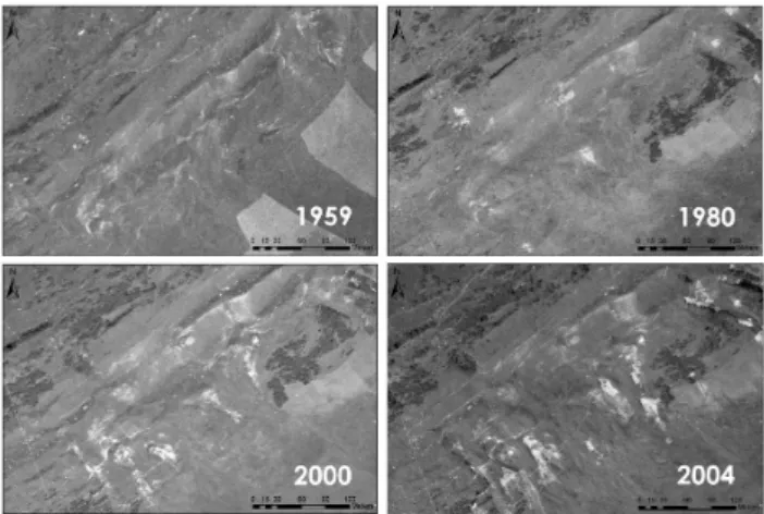
Fig. 3.Sub-images of air photographs showing the stages of land-slide hazard for the years 1959, 1980, 2000, and 2004.
geology and slope to be the most decisive quasi-static catch-ment characteristics (Ohlmacher and Davis, 2003; Suezen and Doyuran, 2004; Ayalew and Yamagishi, 2005). How-ever, beside the static environmental catchment conditions, the relevance of dynamic anthropogenic changes on the tem-poral evolution of landslide incidence is crucial to know. 4.2 Evolution of landslide incidence compared to
human-induced changes
The area affected by landslides increased dramatically since 1959. Figure 3 gives a visual impression of the destabili-sation of a lower south-exposed slope over the years. The mapping of the stages of landslide incidence revealed that, once the slope is degraded by trails and landslides, it might take decades to recolonise the bare spots with vegetation.
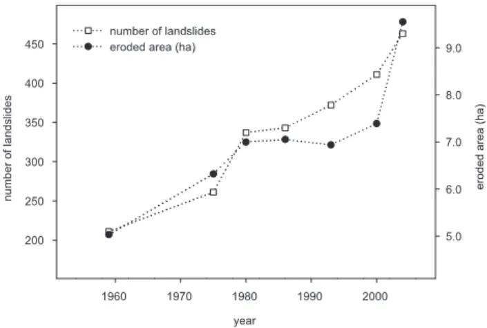
Fig. 4. Progression of the number of landslides and eroded area by landslides for the entire catchment since 1959. The error of the mapped landslide area is approximately 10%.
between 1959 and 2004 (increase of 92%). The average depth of 10 measured landslides was 1.5 m. Given the eroded area and assuming a bulk density of 1.2 t m−3, we estimated a
mean sediment rate of 0.6 t ha−1yr−1due to landslides only.
According to sheet erosion rates for agricultural low lands, this value is classified as low soil loss. However, due to the higher vulnerability of alpine regions the areal damage is dra-matic.
In order to explain the increasing trend, the evolution of landslide incidence is compared to other causative factors that changed over time and have a geophysical association to landslide triggering, as described below. Trends in landslide activity might also be caused by geomorphologic feedback mechanisms i.e. older landslides can undercut and steepen a slope and trigger new landslides. However, the induced feed-back mechanisms are not exclusively positive. Claessens et al. (2007) showed that landslides also stabilise some parts of the slope due to the canalisation of the runoff in the eroded area. A quantification of the balance between sta-bilising and destasta-bilising feedback effects could not be ac-complished for the scale considered in our study. Thus, an effect of positive feedback mechanisms might be involved in the observed trend in landslide activity. Moreover, new land-slides occurred mostly sideways to older ones or at sites, that were formerly free of landslides (note that triggering interac-tions show a upslope/downslope shifting pattern (Claessens et al., 2007). We thus assume that legacy effects are of minor importance. The use of hydropower and accompa-nying changes of slope humidity can be excluded as possi-ble explanation for the landslide increase, because the hy-dropower station in Realp was already commissioned in 1913 (EWU, http://www.ew-ursern.ch/docs/wasserkraft.cfm; Ac-cess date: 06.08.2007).
4.2.1 Climate factors: avalanche frequency and precipita-tion
The analysis of time-series data showed that several dynamic factors change simultaneously in the Urseren Valley. This impedes the determination of a definite causation of the land-slide trend. Moreover, the temporal resolution of the air pho-tographs to analyse the landslides is too low and too irregular, to deduce significant correlations. Nonetheless, in the fol-lowing correlation coefficients are presented to supplement the graphical illustrations.
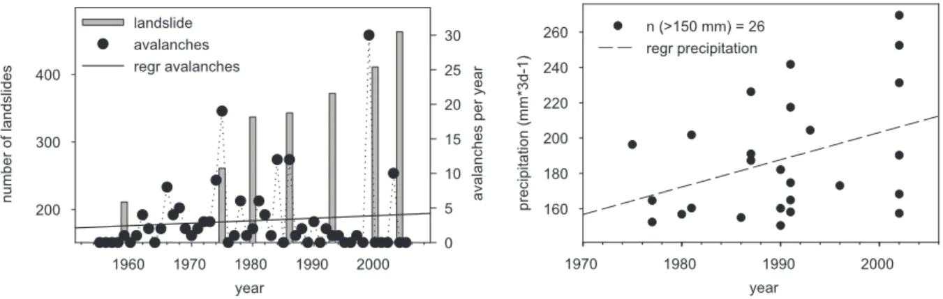
Climate change affects soil stability directly via modifi-cation of precipitation characteristics and via temperature ef-fects on soils (e.g. melting of permafrost). Indirect efef-fects in-clude the alteration of vegetation cover and snow processes. We evaluated the frequency of avalanches over time as one important proxy for changes in snow dynamics. Avalanches are regarded as potential landslide risk factors because of the additional friction forces that may trigger tension fis-sures. The time-series of avalanches show a slightly increas-ing trend of the linear regression. However, the latter is only due to the high number of avalanches in the winter of 1999 (Fig. 5 left). Apart from that extreme event no trend over time is distinguishable. A direct comparison between the time-series of the number of avalanches and number of landslides for single years in the valley did not result in a clear relation-ship (rsp=−0.43,P=0.38). Although there is a connection between spatial pattern of avalanches and landslides (Fig. 2b, see discussion above), no temporal correlation was found, e.g. the winter of 1999 with 30 avalanches did not cause a noticeable rise of the eroded area in 2000. Avalanches might trigger landslide events in subsequent years due to a general destabilisation of slopes. However, the absence of tension fissures in the field and the time-series data lead to the con-clusion that avalanches do not directly triggered landslides at our site but rather occur in the same places, because the stability of snow cover and stability of soils are controlled by similar environmental conditions. To conclude, we could not identify avalanches as a causative factor for the landslide trend.
Generally, landslides and precipitation are related by a threshold function (Guzzetti et al., 1999; Zhou et al., 2002) as soil strength properties are a function of soil water content. However, the Spearman correlation coefficients between pre-cipitation characteristics (yearly maximum 1 day-events, – 3 day-events and –5 day-events; yearly mean precipitation) and landslides were not significant. The Mann-Kendall’s Tau test was not significant for mean precipitation data of the An-dermatt station, too. However, for torrential events>150 mm 3d−1 a significant (P<0.05) increase of 1.32 mm 3d−1 per
year is evident (Fig. 5 right). Thus exceedance of the land-slide triggering threshold became more likely.
Fig. 5.Increase of the number of landslides in comparison to the climate factors: frequency of avalanches per year (left) and yearly maximum 3-days precipitation events (right).
Fig. 6.Land use intensification (left) and a comparison between the increased landslide- and stocking numbers (right).
triggered at least 17 landslides (Berger, August 2005; Swis-sphoto; personal communication) and mainly contributed to the affected area we observe in 2004. Extreme events from August 1987 (226 mm in three days) and November 1991 (242 mm in three days) also triggered several landslides. However, no triggering event could be observed between 1993 and 2000.
The observed increased frequency and intensity of tor-rential rainfall events is in correspondence with the gener-ally described climate change effects (IPCC, 2007). More-over, precipitation is expected to increase more in the winter (Beniston, 2006) when vegetation is sparse. The most severe events were observed in November in the Urseren Valley. On lower altitudes, precipitation will less often fall as snow while for higher altitudes a thicker snow pack in spring is pre-dicted that results in more intense snowmelt events (Benis-ton, 2006). Thus, landslide hazard can be expected to in-crease through the described effects (Frei et al., 2007). Our analysis of extreme 3-day precipitation events seem to con-firm this statement.
4.3 Land use factors: Intensity, management practices and land-cover
4.3.1 Land use intensity
Besides the climatic factors the triggering of landslides is de-pendent on intensity and type of land use (Schauer, 1975; Bunza, 1984; Tasser et al., 2003). Land use was mainly in-tensified in the valley during the last decades, which is shown by the decreasing pasture area per animal (Fig. 6 left). Since 1955, the pasture space per cow steadily decreased for two reasons (i) an increase in cow numbers from 785 to 1482 and (ii) a reduction of cow pasture area. Pasture area per sheep also decreased until 1992 due to an increase of sheep from 1193 in 1955 to 7875 in 2006. The sheep pastures were en-larged in 2006. Goats are of minor importance in the valley and decreased from approximately 550 goats in 1976 to 280 in 2005.
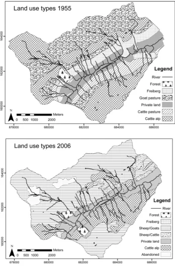
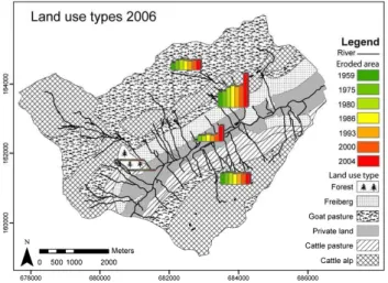
Fig. 7.Pasture maps for the year 1955 and 2006.
years was not significant. One reason is that the interaction with the triggering rainfall event and even the timing of the event needs to be considered. A multiple regression with stocking increase and yearly maximum 3 day-events could improve the explained variance (R=0.4) of the land-slide development but was still not significant. Both predic-tors showed similar significance in the multiple regression (stocking number of sheep and cattleP=0.52, yearly max-imum 3 day-eventsP=0.58). A reason for the low signifi-cance of the predictors is the usually non-linear relationship between landslides and its triggering factors. Rainfall events, for example, need to exceed a certain threshold to initialise landslides. Moreover, significant correlations might be ob-scured by the low temporal resolution of the air photographs (and thus low resolutions of landslide increase).
4.3.2 Land use management practice
Land use management practice is a further dynamic factor. The change of management practice is apparent from the pasture maps of 1955 and 2006 (Fig. 7). The private land
is situated at the valley floor and adjacent slopes. Different forms of pastures (goat, cattle, and sheep) can be found on the slopes. Comparing the two maps, the following develop-ments are noticeable between 1959 and 2006:
a) Goat pastures disappeared in 2006.
b) The traditional land use type called “Freiberg” almost disappeared. “Freiberg” areas are pastures, which are used in spring because of the vicinity to the farms and the more advanced vegetation state at this altitudinal level. The 14th June is the appointed date to bring the cattle to the higher pastures. For the rest of the summer the Freiberg is kept as a reservoir in case of an early onset of the winter and is left to regenerate during the main growing season (note that the “Freiberg” were situated in the geological sensitive area of the Mesozoic layer).
c) Remote and less productive areas were abandoned. d) Alpine cattle alps, which are high mountain pastures exclusively used during summer, disappeared completely to give way for sheep pastures.
Interviews with two farmers were conducted to complete the information of the pasture maps. The farmers were asked which kind of land use changes happened and where changes in land use intensity occurred since 1955. The observations and experiences of the farmers can be summarised in two general developments: (i) an intensification of the areas close to the valley (point 1 to 6, see below) and (ii) an extensifica-tion of remote areas (point 7 to 9, see below). The develop-ments are ascribed to the following agricultural changes that agree with developments described for other alpine regions (Tasser and Tappeiner, 2002; Troxler et al., 2004; Mottet et al., 2006; Tappeiner et al., 2006; Baur et al., 2007):
Fig. 8.Progression of landslide affected area on different traditional land use types of 1955.
Most of the changes took place in the beginning of the 1970s as local agriculture became mechanised and traditional farming practices were abandoned. To show the effect of the above described developments on soil stability, the landslide areas for single years are displayed for each traditional land use type of 1955 (Fig. 8). The remote and extensively used pastures were already slightly affected by landslides in 1959, but no increase in landslides could be observed over time. Today these areas are almost exclusively used as sheep pas-tures. The latter might indicate that sheep are not the main cause of the increase of landslide frequency. However, the data basis does not allow deducing recommendations for a specific pasture animal because the sheep and cattle pastures differ too much in catchment characteristics. Additionally, cattle pastures are temporarily used as sheep pastures; espe-cially in spring when soils are most sensitive. The intensified areas closer to the valley floor (the former “Freiberg” and private land) have clearly destabilised. The “Freiberg” zone was already the most affected zone in 1959 due to its vul-nerable geology, whereas the private land at that time was almost undisturbed.
4.3.3 Land-cover: shrub encroachment
Parallel and partly due to the above described changes in grassland management we determined an alteration of land-cover, which manifests in an encroachment of shrubs. Land-cover was not an independent parameter. Nor did it signif-icantly improve the explained variance of the spatial land-slide distribution in the multiple logistic regression model. Nonetheless, to evaluate the effect of land-cover change on the landslide trend, landslide densities are presented for the unchanged land-cover types and the areas that changed since 1959 separately (Table 1).
The shrub-cover was the only land-cover category, which showed considerable change over time. The area covered by shrubs increased since 1959 by 30.0%. The landslide density
Table 1. Landslide densities for unchanged land-cover types and areas, that were invaded by shrubs since 1959 (new shrub).
land-cover landslide density (%)
forest 0.0
debris 7.5
new shrub 2.9
shrub 33.2
grassland/dwarf-shrub 56.4
is 33.2% for the community of old shrubs, but only 2.9% for the new shrubs. The older shrub cover mainly occurs in typ-ical places forAlnus viridisi.e. on sites with wet conditions, like tributary channels on the north-facing slope. Especially these wet and steep areas close to channels are susceptible to landslides. The new shrub cover, however, occurred in untypical places forAlnus viridison the plains between the channels and on the south exposed slope. These recently in-vaded areas show low susceptibility to landslides. The high-est landslide densities could be observed for vegetation com-munities (defined in chapter 2) of dwarf-shrub and grassland (56.4%). Debris is with 7.5% relatively less susceptible to landslide activity, as the inhomogeneous mixture of materi-als and grain sizes stabilises the soils. The small forested area (0.7% of the catchment) is not affected by landslides.
effect ofAlnus viridisfrom our data and can not exclude that Alnus viridisinvaded preferably the more stable regions for some unknown reasons.
To summarise, we can see a clear impact of the changed management practice in the Urseren Valley: The accessible, more intensely used areas destabilised whereas areas of ex-tensification to the point of abandonment did not destabilise. The effect of abandonment and the subsequent succession states on slope stability has been discussed in literature in detail (Schauer, 1975; Karl, 1977; Bunza, 1984; Newesely et al., 2000; Tasser et al., 2003). The fact that a reduction of the agricultural use enhances landslides risk is ascribed to in-creased snow-gliding on these areas (Schauer, 1975), to the higher vulnerability of the succession states and less main-tenance (Tasser et al., 2003). For the Urseren Valley, this effect could not be observed. One possible explanation is that an increase of landslides on abandoned land mainly oc-curs on areas with a slope above 58◦inclination (Karl et al.,
1985; M¨ossmer, 1985; B¨atzing, 1996), where we could not observe landslides in the Urseren Valley. Furthermore, areas recently (since 1959) colonised by Alnus viridisshow low landslide density. Mainly species such asAlnus viridis, Sor-bus aucupariaandRhododendron ferrugineuminvade in the Urseren Valley, which are believed to increase soil stability. This is crucial information because the invasion of shrubs, is observed for the whole sub-alpine belt of the Swiss Alps. An increase of almost 11.8% was assessed forAlnus viridis be-tween 1983/85 and 1993/1995 (Brassel and Br¨andli, 1999).
We found that the consequence of abandonment of the remote pastures which is the accompanying intensification through concentration of animals on smaller areas in combi-nation with increasing stocking numbers is a greater threat to soil stability than the abandonment itself. Although less pronounced than in the Urseren Valley, this is a general agri-cultural development in the Swiss Alps (Baur et al., 2007; Troxler et al., 2004). The area of summer pastures steadily decreases (from 612 619 ha in 1954 to 465 519 ha in 2005 BFS, 2005) due to abandonment and subsequent emergence of shrubs and reforestation but simultaneously the stocking numbers increase. For example the summered sheep in-creased from 200 000 to 420 000 in the last 40 years (Troxler et al., 2004) and the livestock unit from 401 921 in 1954 to 416 566 in 1992 (Baur et al., 2007).
The change in management practice is driven by the de-crease of farm numbers and farmers, which resulted in less maintenance and the abandoning of time-consuming tradi-tional farming practices and non-profitable farmland since the early 1960s. In general, this leads on the one hand to abandonment and on the other hand to an intensification of the most profitable and accessible areas in the Swiss Alps and other mountainous regions (Tasser and Tappeiner, 2002; Mottet et al., 2006 ). These two extreme states of land use intensity are believed to be most vulnerable to landslides (Tasser and Tappeiner, 2002) and will most likely increase in the future.
5 Conclusions
We found a natural susceptibility of the catchment to land-slides that has been proved by multivariate analysis. Geology and slope were identified as plausible factors to explain the spatial variation of landslides. However, quasi-static envi-ronmental factors like geology, and morphology cannot ex-plain the temporal trend in landslide activity. The increase of the landslide area of 92% within 45 years confirms our hypothesis that dynamic factors like climate and land use de-cisively influence the landslide pattern that we observe to-day. The analysis of the time-series of avalanches revealed that avalanches seem to be of minor importance in trigger-ing landslides. The increase of extreme rainfall events and the increased stocking of the pastures are likely to have en-hanced the landslide hazard. In order to quantify the propor-tion of climate change and to separate its impact form land use the application of a deterministic landslide model seems a promising future task (Collison et al., 2000; Schmidt and Dikau, 2004). In addition to stocking numbers, the change in management practices is decisive. Extensively used or aban-doned areas with recently emerging shrub vegetation show low landslide densities in the Urseren Valley and were not responsible for the landslide trend.
Land use affected the spatial distribution of landslides and created new landslide risk areas. In this context, it was shown that not abandonment itself but the accompanying intensifi-cation of accessible regions poses a major threat to soil sta-bility in the valley. Although we cannot infer quantitative relationships between landslide hazard and anthropogenic impacts, our data indicate an increase of landslide hazard that duplicated the affected area by landslides. The case study in the Urseren Valley clearly highlights the relevance of dynamic anthropogenic driven impacts on landslide haz-ard. Many of the described developments are representative for other alpine regions, however, it remains to be shown if the impact on landslides is as significant.
Even though estimated soil loss due to landslides might be low compared to arable areas (0.6 t ha−1yr−1compared
to 2– t ha−1yr−1as a limit value in the Swiss soil protection
Acknowledgements. This study was funded by the Swiss Federal Office for the Environment. The authors gratefully acknowledge the supply of data by MeteoSwiss, Korporation Urseren, Swiss Federal Institute for Snow and Avalanche Research (SLF), and Swissphoto. Furthermore, we would like to thank T. Labhart, M. Mueller and the members of the Transdisciplinary Project Urseren (TPU) for valuable support and discussions.
Edited by: K.-T. Chang
Reviewed by: L. Claessens and three other anonymous referees
References
Ahnert, F.: Einf¨uhrung in die Geomorphologie, third edition ed., UTB, Stuttgart, 440 pp., 2003.
Alewell, C., Meusburger, K., Brodbeck, M., and B¨anninger, D.: Methods to describe and predict soil erosion in mountain regions, Landscape and Urban Planning, in press, 2008.
Andre, M. F.: Depopulation, land-use change and landscape trans-formation in the French Massif Central, Ambio, 27, 351–353, 1998.
Ayalew, L. and Yamagishi, H.: The application of GIS-based logis-tic regression for landslide susceptibility mapping in the Kakuda-Yahiko Mountains, Central Japan, Geomorphology, 65, 15, 2005. Ayalew, L., Yamagishi, H., Marui, H., and Kanno, T.: Landslides in Sado Island of Japan: Part II. GIS-based susceptibility mapping with comparisons of results from two methods and verifications, Eng. Geol., 81, 432–445, 2005.
BAFU: Article 18 of the Ordinance of 7 December 1998. Relating to Agricultural Terminology (SR 910.91), Swiss Federal Office for the Environment (German: BAFU), 2001.
B¨atzing, W.: Landwirtschaft im Alpenraum – Ans¨atze f¨ur eine Synthesedarstellung, in: Europ¨aische Akademie Bozen (Hrsg.), Landwirtschaft im Alpenraum – unverzichtbar, aber zukunftslos, Blackwell Wissenschaftsverlag, Berlin, 229–242, 1996. Baur, P., M¨uller, P., and Herzog, F.: Alpweiden im Wandel, AGRAR
Forschung, 14, 254–259, 2007.
Beniston, M.: Mountain weather and climate: A general overview and a focus on climatic change in the Alps, Hydrobiologica, 562, 3–16, 2006.
BFS: The changing face of landuse. Landuse statistics of Switzer-land, Bundesamt f¨ur Statistik, Bern, 2001.
BFS: Arealstatistik Schweiz: Zahlen – Fakten – Analysen, Bunde-samt f¨ur Statistik, Neuchˆatel, 99, 2005.
Brassel, P. and Br¨andli, U.: Schweizerisches Forstinventar, Ergebnisse der Zweitaufnahme 1993–1995, Birmensdorf, Eid-gen¨ossische Forschungsanstalt f¨ur Wald, Schnee und Landschaft, Bundesamt f¨ur Umwelt, Wald und Landschaft, Bern, 1999. Bunza, G.: Oberfl¨achenabfluss und Bodenabtrag in alpinen
Grass¨okosystemen, Ver. Ges. ¨Okol., 12, 101–109, 1984. Carrara, A., Cardinali, M., Detti, R., Guzzetti, F., Pasqui, V., and
Reichenbach, P.: GIS techniques and statistical-models in evalu-ating landslide hazard, Earth Sur. Proc. Land, 16, 427–445, 1991. Carson, M. A.: The mechanics of erosion, Pion Ltd., London, 174
pp., 1971.
Cernusca, A., Bahn, M., Chemini, C., Graber, W., Siegwolf, R., Tappeiner, U., and Tenhunen, J.: ECOMONT: a combined ap-proach of field measurements and process-based modelling for
assessing effects of land-use changes in mountain landscapes, Ecological modelling, 113, 167–178, 1998.
Claessens, L., Lowe, D. J., Hayward, B. W., Schaap, B. F., Schoorl, J. M., and Veldkamp, A.: Reconstructing high-magnitude/low-frequency landslide events based on soil redistribution modelling and a Late-Holocene sediment record from New Zealand, Geo-morphology, 74, 29–49, 2006.
Claessens, L., Schoorl, J. M., and Veldkamp, A.: Modelling the location of shallow landslides and their effects on landscape dy-namics in large watersheds: An application for Northern New Zealand, Geomorphology, 87, 16–27, 2007.
Clerici, A., Perego, S., Tellini, C., and Vescovi, P.: A GIS-based automated procedure for landslide susceptibility mapping by the Conditional Analysis method: the Baganza valley case study (Italian Northern Apennines), Environ. Geol., 50, 941– 961, 2006.
Collison, A., Wade, S., Griffiths, J., and Dehn, M.: Modelling the impact of predicted climate change on landslide frequency and magnitude in SE England, Eng. Geol., 55, 205–218, 2000. Dai, F. C. and Lee, C. F.: Landslide characteristics and slope
insta-bility modeling using GIS, Lantau Island, Hong Kong, 42, 213, 2002.
Descroix, L. and Gautier, E.: Water erosion in the southern French alps: climatic and human mechanisms, CATENA, 50, 53–85, 2002.
Dommermuth, C.: Beschleunigte Bodenabtragungsvorg¨ange in der Kulturlandschaft des Nationalparks Berchtesgaden. Ursachen und Auswirkungen aufgezeigt am Beispiel des Jennergebiets, Forstwissenschaftliches Centralblatt, 114, 285–292, 1995. Douglas, T., Critchley, D., and Park, G.: The deintensification of
terraced agricultural land near Trevelez, Sierra Nevada, Spain, Global Ecol. Biogeogr. Lett., 4, 258–270, 1996.
Frei, C., Calanca, P., Sch¨ar, C., Wanner, H., Schaedler, B., Hae-berli, W., Appenzeller, C., Neu, U., Thalmann, E., Ritz, C., and Hohmann, R.: Grundlagen.Klima¨anderungen und die Schweiz 2050 – Erwartete Auswirkungen auf Umwelt, Gesellschaft und Wirtschaft., OcCC Report, OcCC Report, 2007.
Glade, T.: Landslide occurrence as a response to land use change: a review of evidence from New Zealand, CATENA, 51, 297–314, 2003.
Graf, C., Boell, A., and Graf, F.: Pflanzen im Einsatz gegen Ero-sion und oberfl¨achennahe Rutschungen, Eidgen¨oss. Forsch.anst. WSL, Birmensdorf, 2003.
Gray, D. H. and Leiser, H. T.: Biotechnical slope protection and ero-sion control, Van Nostrand Reinlold, New York, 288 pp., 1982. Greenway, D. R.: Vegetation and slope stability, Anderson, M.
G.and Richards, K. S., Slope Stability., Wiley, Chichester, New York, 187–230, 1987.
Guzzetti, F., Carrara, A., Cardinali, M., and Reichenbach, P.: Land-slide hazard evaluation: a review of current techniques and their application in a multi-scale study, Central Italy, Geomorphology, 31, 181, 1999.
Helsel, D. R., Mueller, D. K., and Slack, J. R.: Computer Program for the Kendall Family of Trend Tests, Scientific Investigations Report 2005–5275, 4, 2006.
for policymakers., 661, 10th session of working group I of the IPCC, Paris, 2007.
K¨agi, H. U.: Die traditionelle Kulturlandschaft im Urserental: Beitrag zur alpinen Kulturgeographie, PhD thesis at University of Zurich, Switzerland, 212, 1973.
Karl, J.: Oberfl¨achenabfluss und Bodenabtrag auf brachliegen-den extensiv genutzten Fl¨achen, DVWK (Deutscher Verband f¨ur Wasserwirtschaft und Kulturbau), 34, 1977.
Karl, J., Porzelt, M., and Bunza, G.: Oberfl¨achenabfluss und Boden-abtrag bei k¨unstlichen Starkniederschl¨agen, DVWK (Deutscher Verband f¨ur Wasserwirtschaft und Kulturbau), 71, 37–102, 1985. Komac, M.: A landslide susceptibility model using the Analyti-cal Hierarchy Process method and multivariate statistics in pe-rialpine Slovenia, Geomorphology, 74, 17, 2006.
Krohmer, J. and Deil, U.: Dynamic and conservative landscapes? Present vegetation cover and land-use changes in the Serra de Monchique (Portugal), Phytocoenologia, 33, 767–799, 2003. K¨uttel, M.: Zur Vegetationsgeschichte des Gotthardgebietes,
Mit-telungen der Naturforschenden Gesellschaft Luzern, 31, 100– 111, 1990a.
K¨uttel, M.: Der subalpine Schutzwald im Urserental – ein inelastis-ches ¨Okosystem, Bot. Helv., 100/2, 1990b.
Labhart, T. P.: Planbeilage: Geologisch-tektonische ¨
Ubersichtskarte Aarmassiv, Gotthardmassiv und Tavetscher Zwischenmassiv, Balkema A. A., Rotterdam, 1999.
Luginbuhl, J.-M., Green, J. T., Poore, M. H., and Conrad, A. P.: Use of goats to manage vegetation in cattle pastures in the Ap-palachian region of North Carolina, Sheep and Goat Res. J., 16, 124–135, 2000.
M¨ossmer, E. M.: Einflussfaktoren f¨ur die Blaikenerosion auf bewei-deten und aufgelassenen Almfl¨achen im kalkalpinen Bereich der Landkreise Miesbach und Rosenheim, Forstliche Forschungs-berichte M¨unchen, 1985.
Mottet, A., Ladet, S., Coque, N., and Gibon, A.: Agricultural land-use change and its drivers in mountain landscapes: A case study in the Pyrenees, Agriculture, Ecosystems and Environment, 114, 296–310, 2006.
Newesely, C., Tasser, E., Spadinger, P., and Cernusca, A.: Effects of land-use changes on snow gliding processes in alpine ecosys-tems, Basic Appl. Ecol., 1, 61–67, 2000.
Ohlmacher, G. C. and Davis, J. C.: Using multiple logistic regres-sion and GIS technology to predict landslide hazard in northeast Kansas, USA, Eng. Geol., 69, 331, 2003.
Petley, D., Hearn, G., Hart, A., Rosser, N., Dunning, S., Oven, K., and Mitchell, W.: Trends in landslide occurrence in Nepal, Nat. Hazards, 43, 23–44, 2007.
Pi´egay, H., Walling, D. E., Landon, N., He, Q. P., Li´ebault, F., and Petiot, R.: Contemporary changes in sediment yield in an alpine mountain basin due to afforestation (The upper Drome in France), CATENA, 55, 183–212, 2004.
Rickli, C., Zimmerli, P., and B¨oll, A.: Effects of vegetation on shallow landslides: an analysis of the events of August 1997 in Sachseln, Switzerland, International Conference on Landslides, Causes, Impacts and Countermeasures, Essen, 575–584, 2001.
Ritzmann-Blickenstorfer, H.: Historische Statistik der Schweiz, Chronos Verlag, Z¨urich, 1996.
Santacana, N., Baeza, B., Corominas, J., De Paz, A., and Marturia, J.: A GIS-based multivariate statistical analysis for shallow land-slide susceptibility mapping in La Pobla de Lillet area (Eastern Pyrenees, Spain), Nat. Hazards Earth Syst. Sci., 30, 281–295, 2003, http://www.nat-hazards-earth-syst-sci.net/30/281/2003/. Schmidt, J., and Dikau, R.: Modeling historical climate variability
and slope stability, Geomorphology, 60, 433–447, 2004. Shrestha, D. P., Zinck, J. A., and Van Ranst, E.: Modelling land
degradation in the Nepalese Himalaya, CATENA, 57, 135, 2004. Sparling, G., Ross, D., Trustrum, N., Arnold, G., West, A., Speir, T., and Schipper, L.: Recovery of topsoil characteristics after landslip erosion in dry hill country of New Zealand, and a test of the space for time hypothesis, Soil Biol. Biochem., 35, 1575– 1586, 2003.
Suezen, M. L. and Doyuran, V.: Data driven bivariate landslide sus-ceptibility assessment using geographical information systems: a method and application to Asarsuyu catchment, Turkey, Eng. Geol., 71, 303–321, 2004.
Swisstopo: Reproduziert mit Bewilligung von swisstopo, BA071108, Zurich, 2006.
Tappeiner, U., Tasser, E., Leitinger, G., and Tappeiner, G.: Land-nutzung in den Alpen: historische Entwicklung und zuk¨unftige Szenarien, Die Alpen im Jahr 2020, alpine space-man and envi-ronment, 1, 23–39, 2006.
Tasser, E. and Tappeiner, U.: Impact of land use changes on moun-tain vegetation, Appl. Veg. Sci., 5, 173–184, 2002.
Tasser, E., Mader, M., and Tappeiner, U.: Effects of land use in alpine grasslands on the probability of landslides, Basic Appl. Ecol., 4, 271–280, 2003.
Troxler, J., Chatelain, C., and Schwery, M.: Technical and economi-cal evaluation of grazing systems for high altitude sheep pastures in Switzerland, Grassland Science in Europe, 9, 590–592, 2004. Van Westen, C. J. and Lulie Getahun, F.: Analyzing the evolution of the Tessina landslide using aerial photographs and digital ele-vation models, Geomorphology, 54, 77, 2003.
Vanacker, V., Vanderschaeghe, M., Govers, G., Willems, E., Poe-sen, J., Deckers, J., and De Bievre, B.: Linking hydrological, infinite slope stability and land-use change models through GIS for assessing the impact of deforestation on slope stability in high Andean watersheds, Geomorphology, 52, 299–315, 2003. Wiedmer, E. and Senn-Irlet, B.: Biomass and primary productivity
of an Alnus viridis stand – a case study from the Sch¨achental valley, Switzerland, Bot. Helv., 116, 55–64, 2006.
WRB: IUSS Working Group World reference base for soil re-sources, Rom, 128 pp., 2006.
Wyss, R.: Die Urseren-Zone – Lithostatigraphie und Tektonik, Eclogae Geol. Helv., 79, 731–767, 1986.