and urban economic development:
the case of Belém and Manaus*
Wouter Jacobs Lee Pegler Manoel Reis Henrique Pereira
Abstract
This paper addresses the fraught relationships among commodity trade, urban economic development and the environment in the world’s largest rainforest reserve, in a historical narrative fashion. The conceptual framework in which we position this narrative is provided by Hesse (2010), in the “site” and “situation” dimensions of the interaction between places or locales on the one hand, and material flows or global value chains on the other. It is argued that the assemblage of both site and situation is what shapes the wealth of cities. The case study of Manaus and Belém shows how the rapid urbanization of the Amazon rainforest is accompanied by the growth of shipping as “new” commodities are being extracted from the jungle interior.
Keywords: urban development; shipping; Amazon; Manaus; Belém.
Introduction
Manaus is experiencing an economic boom - largely due to its Free Trade Zone and its hub location the coastal city of Belém is running the risk of being bypassed by these new commodity flows which consequently affects the city’s ability to upgrade its urban economic profile.
As such this chapter describes the economic fortunes of two Amazon cities in a historical narrative fashion. The conceptual framework in which we position this narrative is provided by Markus Hesse (2010) on the ‘site’ and ‘situation’ dimensions of the interaction between places or locales on the one hand, and material flows or value chains on the other. As Hesse (2010) argues, cities are the agglomerated outcomes of, and prosper due to, the assemblage of both site and situation. In other words, it is the relational interface between locational assets (including not only classical production factors, but also territorialized institutions or locally based routines and skills), the actual material flows or goods movement, and the management and governance of these flows that shape the fortunes of cities.
The dynamics and geography of assemblage has changed considerably since the 1980s as a result of the integration of world trade and disintegration of production systems (Feenstra 1998), generating a new spatial division of labor at a global scale (Fröbel et al.1980). The result of this process of accelerated globalization is that the movement of particular commodities and components have become both more spatially dispersed and spatially extended, while at the same time organized according to logistics principles of just-in-time, reliability and flexibility. This development is conceptualized by economic geographers as the emergence of Global Production Networks (Coe et al. 2004) and what transport economists call global supply chain systems (Robinson 2002).
At the same time, cities as gateways or hubs still need to spatially accommodate physical goods movement itself with all kinds of externalities taking place. Some of the goods movement is to supply the metropolitan region with the necessary consumer goods and production inputs, allowing local businesses to function, jobs to be filled and taxes to be raised. Goods movement, however, creates negative social costs in terms of congestion and pollution which might result in local political resistance. At the same time increasing land values in the urban core will systematically displace low valued distribution facilities (nearby the core) to the urban fringe and, as such, further drive up the costs of transport to service that same urban economic core. In other cases, however, the majority of the goods movement in the region is destined for distant hinterlands. In these cases, much of the negative externalities will reside locally with value capture taking place outside the region. Policymakers and politicians are then confronted with the dilemma to accommodate such freight flows at all or whether they should opt for more valued urban functions to be developed. A change in direction is not easily made as the government’s powers are limited, while sunk costs in infrastructure, natural resource dependency and vested industrial interests might shape the development agenda into certain paths for decades to come (Martin and Sunley 2006).
network), but also the availability of a skilled labor force, of favorable government regulations and of a well-informed and equally equipped government agency (Hall and Jacobs 2010). Much in terms of strategic coupling or assemblage is dependent, however, on the economic value and social costs generated and on the agenda of the actors involved. These actors hold different degrees of power and operate under various contexts and at various spatial scales: from the local to the global. Such a perspective implies extending the notion of ‘situation’ beyond the mere physical connections of a location with the urban system at large by including a relational dimension. ‘Situation’ from a relational perspective thus includes the connectivities that exist through social networks, governance arrangements and corporate ties.
Against this background, the chapter raises the threefold question of how the Amazon cities of Belém and Manaus have been historically inserted in the global material flows of particular commodities, what explains their divergent development paths in the late twentieth century and how are they coping with new economic opportunities provided by Brazil’s current commodity boom in terms of sustainable development. In this chapter we refer to Amazonia as the loosely defined, and not formally established, wider region that encompasses the Amazon rainforest. It includes several states under the federal structure of Brazil, of which the state of Amazonas (capital: Manaus) is the largest in terms rainforest reserve and the state of Para (capital: Belém) in terms of economic output.
This chapter is structured as follows. First we describe and explain the economic rise and fall of the cities of Belém and Manaus as result of the rubber boom of the early twentieth century. In the third section we provide an overview of the urbanization of Amazonia that followed during the second half the twentieth century, in particular describing the establishment of the Manaus Free Trade Zone. In the fourth section the ports in Amazonia are positioned within the overall Brazilian transportation system, highlighting how these transport activities and commodity chains are accommodated in space within the metropolitan regions of Manaus and Belém. In addition, we compare the urban economies of Manaus and Belém in terms of freight transportation activity using statistical data. In the fifth section, we address the question of assemblage in the two port cities in the context of Brazil’s current commodity boom. In the conclusions we draw out implications for the future of sustainable development and for further research.
The Amazon Rubber Boom 1870-1920
anus at a later stage, witnessed an unprecedented urban economic boom with both cities rivaling each other with development projects of urban grandeur as is still exemplified by their well-known opera houses.
The Rubber Boom started with the enormous rise of demand for the product in North America and Europe during the close of the nineteenth century. The Amazon provided this ‘new’ commodity in plenty, but its extraction from a remote jungle interior was far from without costs. Its remote and poorly accessible location in combination with its harsh terrain and lack of enforcement of the rule of law increased the price of the commodity enormously. Transshipment costs were in general high, lthough barging along the Amazon River provided some relative relief. Interesting in this context is hat the Brazilian government granted long term concessions to foreign companies to expand and perate the port facilities: British Manaos Harbour Limited in Manaus and the US Port of Para ompany in Belém. What was more, the rubber supply from the Amazon was of the ‘wild’ sort, herefore not rationally cultivated and subject to supply elasticity in global markets. This supply elasticity in combination with increased demands from the global market led to a further ncrease in price and contributed to the regional-frontier boom economy.
Modern Urbanization of the Amazon: Manaus vs. Belém
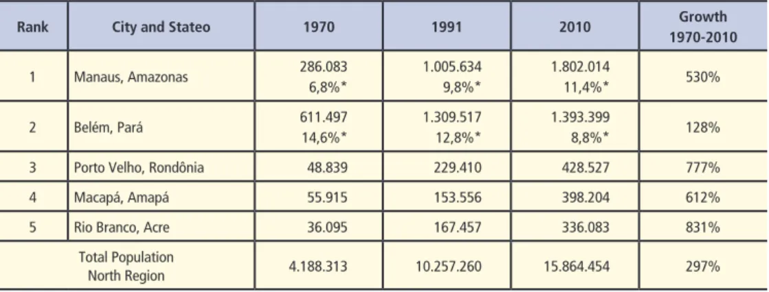
The Amazon Basin has historically been dominated by two cities: Belém and Manaus. While both cities prospered during the rubber boom (and underwent a similar decline afterwards), they experienced diverging development paths since the 1970s. Although both cities are by far the largest urban centers in Amazonia, the last decades can be characterized by an overall urbanization of the region. In 1960 only 37.5 per cent of the population in Amazonia lived in cities. By 1991 the urban population in Amazonia had already increased to 57.8 per cent (Bowder and Godfrey 1997). Although both Belém and Manaus experienced an absolute growth in population over the last decades, the relative share of Belém in the region’s total population dropped considerably while Manaus’ share almost doubled. In fact, of the top 10 cities in the Amazon, Belém actually experienced the lowest growth. What is more, since the late 1990s, Manaus surpassed Belém as the most populous city in the Amazon basin (see Table 1).
Table 1 – Ten largest urban centres (population) in the North Region, 1970-2010
Rank City and Stateo 1970 1991 2010 Growth
1970-2010
1 Manaus, Amazonas 286.083 6,8%*
1.005.634 9,8%*
1.802.014
11,4%* 530% 2 Belém, Pará 611.497
14,6%*
1.309.517 12,8%*
1.393.399
8,8%* 128% 3 Porto Velho, Rondônia 48.839 229.410 428.527 777% 4 Macapá, Amapá 55.915 153.556 398.204 612% 5 Rio Branco, Acre 36.095 167.457 336.083 831%
Total Population
North Region 4.188.313 10.257.260 15.864.454 297% * as percentage of total population of the North Region.
The fortunes of the city of Manaus were to change in 1967 when the federal government approved the development of a Free Trade Zone (FTZ) under Federal Law number 288 (enacted 28 February 1967). In the beginning the FTZ functioned mainly as a tax free zone for imported foreign luxury goods for the Brazilian elite from the southeast. Later on the FTZ managed to attract more substantial industrial activity, most notably the oil and gas refinery plant REMAN (owned by Petrobras), and later on the assembly plants and value added packaging facilities for global consumer electronics companies such as Samsung and LG, for global soft drink brands such as Pepsi Co and Coca-Cola, and automotive brands such as Harley Davidson and Honda. Most of the input materials and components are imported from abroad, in particular from countries in Asia (Japan, Korea, Taiwan, and China). Over the last years the number of firms within the FTZ has fluctuated from around 450-550 firms, creating as many as 100,000 jobs directly in Manaus and around 20,000 in the rest of the 61 municipalities of the western Amazonas state (Brazilian Ministry of External Relations 2006).
While Manaus acts as the major logistics hub in the region and its Polo Industrial de Manaus (PIM) accommodates most of the free trade zone’s industrial activity, the Manaus Free Trade Zone actually extends far beyond its metropolitan boundaries. In fact, the federal government’s declaration of Free Trade Zone status covers the entire northwestern Amazon region and includes the states of Amazonas, Roraima, Rondonia, Acre and Amapa. The FTZ provides all kinds of fiscal benefits as regulated under the 1967 Federal Law 288. This law earmarked certain fiscal incentives until the year 2013. This fiscal program was renewed in 2003 by Federal Law 2826 (29 September 2003) and extends the fiscal concession for firms operating in the Manaus FTZ until 2023. While the fiscal arrangements provided by the federal government at first mainly dealt with imports to the FTZ, they later on also included special arrangements for exports. In addition to these federal fiscal schemes, the Manaus FTZ also benefits from State Government tax exemptions (mainly for the shipment of components manufactured elsewhere in Brazil and destined for the Manaus FTZ) and municipal exemption from the city of Manaus itself (e.g. 10-year exemptions from real estate and property taxes).
Under these fiscal regulations, Manaus enjoyed favorable regime vis-à-vis its direct rival at that time Belém. So ‘assemblage’, in terms of regulatory fiscal arrangements by the federal government, favored Manaus over Belém. In terms of the reasons why Manaus was chosen for this government investment/subsidy scheme, a recent marketing brochure by the Brazilian Ministry of External Relations rather surprisingly frankly mentioned: “The ZFM [the Manaus Free trade Zone] was originally created with the objective of making an economic base in the Western Amazon feasible, promoting the region’s productive integration and serving as a support to guarantee national sovereignty in the region [italics emphasized].” (Brazilian Ministry of External Relations 2006: 6).
extent this can be considered a continuation of national policy during the time of the Rubber Boom, in which the Amazonian countries actively competed for dominion over the area by providing land concession to traders, setting up military outposts and investing in infrastructure (Barham and Coomes 1994). In this modern version, however, the Manaus FTZ resembles more of a ‘growth pole’ developed in many other industrialized countries around the world in which resources and wealth were transferred from the core to the periphery (Brenner 2004). This federally planned concentration of urban economic development in Manaus also helped to prevent the uncontrolled settlement of the rainforest, although the poor quality of the soil and poor road accessibility likely did more to prevent large scale cultivation of rainforest in comparison to Para state.
The management of the Free Trade Zone is in the hands of SUFRAMA, a federal agency in charge of the FTZ policy and its business model. The State governments (and their capital cities) are represented within the SUFRAMA administration and receive financial support from it for projects carried out in line with their State strategic development plans. These plans are designed to coordinate federally initiated regional development policy and objectives with lower tiers of government. The municipalities on the other hand are required to implement these State development plans locally, mainly through land use planning. Thus, there is a clear hierarchy of planning powers and public funding.
Initially, the success of the FTZ until the 1980s could be considered a result of the protectionist national trade policies of the federal government. During that time the federal government created all kinds of unfavorable trade conditions for imports, luring major international firms to set up production facilities for imported materials and components in a Free Trade Zone designed to service the large Brazilian market. Yet in the early 1990s the federal government started to open up for international trade and removed all kinds of tariff barriers, allowing foreign direct investments to concentrate at locations in the major urban regions of the southeast, whereas global traders were now free to locate their production facilities outside Brazil while still servicing the same market. Indeed, as the New York Times (17 December 1990, online content) reported at that time, one of the FTZ’s major employers, electronics company Sharp, decided to hive off two major production lines as a result of these new opportunities provided by international trade. As the director of SUFRAMA put it:
In the nineties when the economic opening occurred, the PIM had an industrial policy that focused on nationalization at any cost and high absorption of labor. The opening meant that companies in the Hub had to face competition from products from all over the world, the same as theirs but at a lower price and with superior quality. We had to change our industrial policy. (Brazilian Ministry of External Relations 2006: 8)
et al. 2010). Thus, as the favorable ‘assemblage’ of Manaus was coming under pressure from the new national trade regime, the existing FTZ-system in place in Manaus in combination with its ‘flexed’ labor regime allowed it to continue to tap into global outsourcing trends, as identified in places such as Tianjin (Wang and Olivier 2006) and Dubai (Jacobs and Hall 2007). Indeed, while the Manaus FTZ primarily functioned as an import hub for the domestic market until the 1990s, its share of exports now currently exceeds 20 per cent. Its main export destinations are other Latin American countries and the United States.
Amazon ports in the Brazilian transportation system
With over 7,400 kilometres of Atlantic coastline, the Brazilian port system is extensive and is characterized by a variety of commodity specializations, with only a limited degree of containerization. This variety in specialization is largely caused by the urban economic and industrial variation of the country. The Brazilian port system can be categorized into four distinct ranges, or what Notteboom (2009) has referred to as multi-port gateway regions. Starting from north to south these are (see Figure 1):
1) Amazon Basin (Belém, Macapá, Santarém, Vila do Conde and reaching as far inland as Manaus and Porto Velho);
2) Northeast (Itaqui, Pecém, Recife, Suape, Salvador, Aratu and in the near future Ilhéus); 3) Southeast (servicing the Belo Horizonte, Rio de Janeiro, Sao Paulo, Curitiba mega-city region through primary ports such as Santos, Sepetiba, Sao Sebastião, Paranaguá, Vitoria);
4) The Far South; Santa Catarina/ Rio Grande do Sul (Itajaí, Imbituba, São Francisco do sul, Porto Alegre, Rio Grande).
Figure 1 – Multi-port gateway regions and urban centres in Brazil
it in the top ten. However this is not verified by data provided by the American Association of Port Authorities (AAPA).
In terms of total cargo throughputs (measured in million metric tons) we observe a different hierarchy. The top ports are now dominated by specialized mining ports such as Itaqui, Sepetiba and Tubarao owned by Brazilian mining giant Vale. The port of Belém is the country’s tenth busiest port in terms of total cargo throughputs, largely due to dry bulk traffic. However, much of the traffic might siphon away to the new facilities of Vale in Ponta da Madeira (see more below). The other top ports are in the liquid bulk sector. These include the oil ports Sao Sebastião, Angra dos Reis and Aratu. The port of Manaus, although located 900 nautical miles inland, ranks eighth in terms of liquid bulk traffic (mainly as a result of the location of the REMAN oil refinery) and tenth in terms of general cargo for a combined total of around 12 million metric tons of traffic in 2008 (AAPA, 2010).
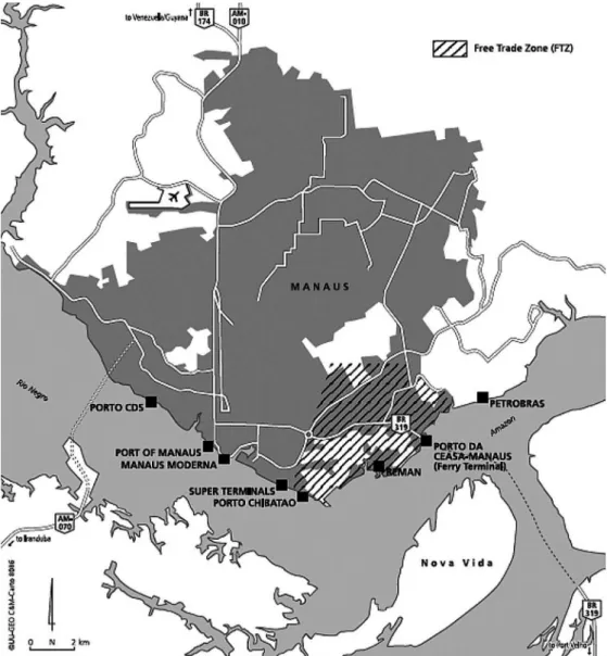
Due to lack of road and rail infrastructure, barge shipping remains the most important mode of transport in this remote region. There are in fact many smaller river ports in the Amazon that serve remote communities. Manaus, in particular, serves as the main hub and final market for regional agricultural produce, most notably for fish, bananas, cassava and timber (Neto et al. 2007). In Manaus (see Figure 2), the port consists of floating piers where the Rio Negro and the Rio Solimões converge into the Amazon. There are three main port operators active. First is the public Port Authority of Manaus which has floating piers upstream and owns 94,923 m2 of land (Government of the State of Amazonas, 2009). It also exploits the cruise terminal. Further downstream is the site of the private operator Super Terminals that owns 9,000 m2 of warehouse space. Third is the private terminal of Porto Chibatao, which operates 17,600 m2 of warehouse space in addition to 70,000 m2 of container yards. Both private operators are directly located south of the Manaus FTZ. A fourth company, Aurora EADI, manages 9,000 m2 warehouse space and 23,000 m2 of container yards (a bonded area) within the Manaus Industrial Hub itself (Figure 2). Most of the goods handled are destined for, and depart from, the Manaus industrial hub PIM by barge towards Belém, Santarem or Porto Velho from where it can be trucked towards to the southeast mega-city region. This particular modal split is because Manaus does not have a direct road link with the main urban centres in the Brazilian southeast. Its road connections are with Porto Velho (where it connects with roads to the Southeast) in the southwest Amazon (BR-319) and Venezuela in the north (BR-174). Most of these are unpaved dirt roads that are unreliable under conditions of excessive rainfall.
As a result of public outrage, the federal agency of natural heritage (IPHAN) declared the `Meeting of the Water` a national monument, effectively suspending the development license granted by the state of Amazonas.
Figure 2 – The Manaus metropolitan region and the location of its ports and FTZ
Private port operator Porto Chibatao also operates a terminal in Porto Velho and warehouse space in Belém (22,600 m2). All the ports in Para State including Belém are controlled by the state port authority Companhados Docas de Para. The public port of Belém is located west of the city centre, adjacent to the passenger terminal and the food market (see Figure 3). Further north is the location of the Porto Miramar terminal, dedicated to a petrochemical refinery. North of the airport there are a number of timber yards where logs from the jungle interior are collected and processed. The main access route from the ports and the city is the BR-316 highway running to Sao Luis and
Figure 3 – The Belém metropolitan region and the location of its ports
eventually connecting with the BR-230 (Trans-Amazonian highway) and the BR-232 (to Suape and Recife). Southwest of Belém on the other side of the waterway is the location of the port of Vila do Conde. It is also the location of a large aluminium mine and smelter owned by Alunorte as well as other aluminium companies (Alubar and Albras).
Urban economics of freight transport in Manaus and Belém
In order to compare the economies of Manaus and Belém in terms of freight related activity, we make use of the location quotient (LQ). The LQ is an index that measures the relative concentration of economic activity within a location compared with the national or regional share of that same activity in the overall economy. As such, the LQ allows us to assess the degree of economic specialization of a location as compared to the national average. An LQ >1 implies a relative specialization of a location (within a particular industry) compared with the national share whereas an LQ<1 implies a relative under-representation. Formally:
Whereby:
LQ = Eij Ej Ei Etotal
E ij= total employment in transport sector j in city i Ej= total employment in transport sector j in Brazil Ei= total employment in city i
E total= total employment in Brazil
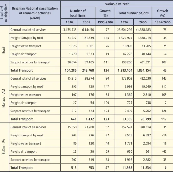
Table 2 – Employment and number of firms in freight transport for Manaus and Belém 1996-2006
Brazilian National classification of economic activities
(CNAE)
Variable vs Year
Number of local firms
Growth
(%) Total number of jobs
Growth (%)
1996 2006 1996-2006 1996 2006 1996-2006
General total of all services 3.475.735 6.144.50 77 23.604.292 41.388.183 75 Freight transport by road 73.927 181.339 145 1.022.927 1.368.014 34 Freight water transport 1.026 1.801 76 18.993 23.705 25 Freight air transport 1.279 1.523 19 42.276 40.444 -4 Support activities for transport 28.054 59.105 111 199.208 401.991 102
Total Transport 104.286 243.768 134 1.283.404 1.834.154 43
General total of all services 15.215 28.974 90 173.902 422.030 143 Freight transport by road 295 729 147 8.992 19.549 117 Freight water transport 107 176 64 1.369 2.810 105 Freight air transport 27 54 100 727 738 2 Support activities for transport 212 474 124 2.497 5.702 128
Total Transport 641 1.432 123 13.585 28.799 112
General total of all services 15.358 23.280 52 252.574 340.814 35 Freight transport by road 202 276 37 7.545 6.797 -10 Freight water transport 86 120 40 1.771 2.094 18 Freight air transport 23 38 65 636 361 -43 Support activities for transport 202 319 58 1.916 2.582 35
Total Transport 513 753 47 11.868 11.834 0
Brazil and
municipalities
Belém – PA
Manaus – AM
Brazil
Source: compiled by the authors from IBGE, 2011.
However, we do see some notable differences between the different subsectors and between Manaus and Belém. For example, the strongest growth among transportation activities is in road transport. In Belém the number of people employed in road transportation actually declined by 10 per cent. Yet in general for Belém, we see a stabilization of the share of transportation activity within the overall urban economy. For Manaus and Brazil as a whole, on the other hand, we see a strong absolute and relative growth in both the number of employees and the number of firms in the transport sector. When we compare the location quotients of Belém and Manaus for the period we observe a distinctive pattern (Table 3).
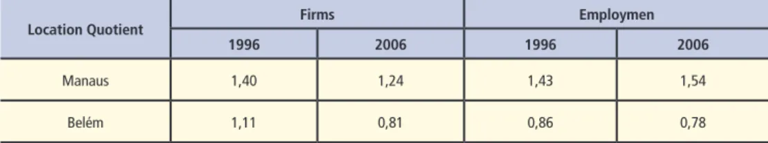
Table 3 – Location Quotients in freight transport for Manaus and Belém 1996-2006
Source: compiled by the authors from IBGE, 2011.
Location Quotient Firms Employmen
1996 2006 1996 2006
Manaus 1,40 1,24 1,43 1,54
Belém 1,11 0,81 0,86 0,78
Towards a new urban assemblage?
Brazil is currently experiencing a new commodity boom, most notably through increased global demands for resources such as oil and gas, soybeans and new agricultural produce (e.g. açai fruits). To what extent are the cities of Manaus and Belém experiencing a new urban assemblage? Based upon contemporary policies and infrastructure investments, the path of development set in motion is likely to favor Manaus more than Belém. While Manaus is benefitting as the central hub location for commodity flows crossing the Amazon, Belém faces serious competition from nearby infrastructure developments and runs the risk of being bypassed altogether. In 2006, the federal government adopted the National Logistics and Transportation Plan (PLNT) in order to facilitate economic growth through infrastructural investment programs and institutional reforms.
Under the government’s PNLT Belém is planned to be connected to the major north-south rail link spanning Belém and the Port of Rio Grande in the extreme south of Brazil. The rail link is already operating between the Carajás railway and Palmas, the capital city of the State of Tocantins. This will enable the connection of Belém to iron ore mines in the state of Pará as well as with the major soybean plantations in the southern states of Piauí and Maranhão. Despite the planned rail link, Belém currently fails to attract infrastructure investments from the private sector. In addition, the port faces locational constraints for expansion at its current location, and its envisaged rail head is not likely to be at the current port location, but southwest of the city at Porto Vila do Conde. Furthermore, Belém is facing competition from new locations being developed in the wider region. In Ponta da Madeira (near Sao Luis), mining giant Vale is currently upgrading existing terminal facilities and is planning to make Ponta da Madeira its largest export centre by the year 2015. Its existing rail link with the mines in the Para state are being upgraded to carry as many 330 car trains at a cost of 4.5 billion reals or approximately 2.8 billion US$ (The Economist, 21-5-2011, p.53-54, 2011). Thus, much of the growth in exports of iron ore will be accommodated in Ponta da Madeira instead of Belém.
knowledge centre for sustainable development. In other words, Vale is investing in human capital in Belém and not in hardware.
In contrast to Belém, Manaus has geography and politics on its side. Its dominant location as the Amazon’s inland trade entrepot safeguards Manaus from pressures as experienced by Belém along the coast where competition is more fierce. In 2010 oil and gas giant Petrobras completed the Uruçu- -Manaus pipeline linking Manaus with the major gas fields 660 km upstream, allowing it to tap into the current commodity bonanza. Moreover, Manaus was selected as one of the host cities of the FIFA 2014 World Cup football, which guarantees federal financial support for infrastructure upgrades including the airport, cruise terminal and the construction of a first bridge over the Amazon. Manaus is also likely to benefit from government plans to improve connections with locations on the Pacific Coast. For example, recently Perú has completed the construction of the Initiative for the Integration of Regional Infrastructure in South America (IIRSA) South road, named Carretera Interoceánca (Bonaz and Urrunaga 2008), connecting the Brazilian city of Assis Brazil (State of Acre) with the Ports of Ilo and Matarani in the south coast of Perú. IIRSA is a transnational development program of the governments in South America to stimulate the integration of infrastructure systems. This will potentially boost the hub status of Manaus and Porto Velho (connected through the Madeira River) due to its connections with the Atlantic and Pacific oceans and with the southeast of Brazil. Another project under study is the Manta-Manaus corridor, linking Manaus with the port of Manta in Ecuador. Interestingly, global terminal operator HPH was granted a concession in Manta, but has pulled out for a second time. At the time of writing, this plan seems more politically driven rather than based upon sound economical analysis.
In terms of the environment, however, the infrastructure upgrading in the Amazon has a great risk of being accompanied by increased deforestation. According to Laurence et al. (2001), transportation projects are the primary source of deforestation in the Brazilian Amazon as they fragment fragile ecosystems and are often accompanied by illegal logging, fires, mining and hunting. Approximately 80 per cent of the deforested area in the Amazon is within 30kms of official roads and highways (Barreto et al. 2005). So, while Manaus and Amazonas state still have the lowest levels of deforestation in the entire Amazon, the upgrading of the BR-319 Manaus-Porto Velho highway will link Amazonas state with the so-called ‘arc of deforestation’ in Rondonia state (Fearnside and Graça 2006) and in its wake the further large-scale cultivation of the planet’s largest rainforest.
Conclusions
however favored to develop Manaus into a free trade zone since the late 1960s. Thus despite the unfavorable ‘site’ of Manaus in the interior as compared to the coastal location of Belém, its status as Brazil’s free trade zone guaranteed a superior ‘situation’ that ultimately supported the economic development of Manaus. Currently, Brazil undergoes enormous economic growth, also largely driven by high international commodity prices. The current growth is accompanied by enormous investments (public and private) in infrastructure as well as institutional reforms to stimulate foreign investments in ports and to stimulate more efficient port governance models.
In this contemporary context it appears that Manaus is more successful in the assemblage of site and situation, thanks in part to its federally supported tax-free zone. Moreover, Manaus and the State of Amazonas take full advantage of its status as federally supported FTZ and as Amazon rainforest capital in international marketing in order to attract foreign direct investments. Paradoxically, it is exactly their ‘site’ within the Amazon jungle interior which provides Manaus and the State of Amazonas a unique selling point for international business by guaranteeing them ‘green cards’ for sustainable operations. The Manaus FTZ is indeed enjoying upgrading towards new value-added chains such as LCD screens and mobile phone devices, while ensuring local R&D expenditures. On the other hand, the FTZ status makes Manaus rather dependent on fiscal incentives from the federal government. More importantly, despite government claims that the concentration of growth in Manaus has preserved 96 per cent of nearby rainforest reserves, one can still question whether promoting growth in such a remote location is indeed sustainable. History teaches that infrastructure upgrading in the Amazon often goes hand in hand with deforestation and large scale land cultivation.
Assemblage in Belém seems to be more restricted, at least in terms of transportation activity and infrastructure development. Despite being located near major iron ore mines and soybean plantations in Para state and government plans for investment in rail connections, the port of Belém lacks space for expansion and is currently missing out on private (foreign) investments as experienced in locations in the northeast. The lack of port-industrial infrastructure investments in Belém might, on the other hand, be a blessing in disguise as it will allow it to move beyond the lock-in experienced by many port-industrial cities. In terms of future research, more empirically informed analysis ‘on the ground’ is needed on two issues. First, research will need to focus on the chains and flows of specific commodities that move through Belém or Manaus and from there on to the global market.
conditions and the environment), the locations of value creation, capture and governance within these chains and the role that logistics processes play. The second line of research needs to deal with developing an empirical understanding of what we would call ‘the politics of assemblage’, that is the strategic coupling by particular actors of the factors of ‘site’ and ‘situation’. In such a perspective we need to empirically study the strategic-relational aspects of assemblage within these two cities and how actors operating at various scales secure their interests. Interesting in this context of territorial governance is that in the state of Para, at the moment of writing, parliamentary initiatives are taken up to split the political and administrative structure of the state into three. Ostensibly this is because of the problems of effective government control over a vast state territory from a single capital in Belém (The Economist, 3-12-2011, p.49/50.). A different interpretation could be that resource dependent interests, iron ore and soy bean, are pushing for administrative-territorial reform exactly in order to secure their economic fortunes.
Within this context, Amazonia is a region that deserves further understanding as it is one of the world’s most precious natural resources. While infrastructure upgrading provides economic opportunities, Amazonia is also an area under great pressure from unsustainable development and capitalist exploitation. To us, the best way to help its preservation is to constantly assess its development and critically engage in research that supports true sustainable development.
Wouter Jacobs
Urban and Regional Research Center Utrecht (URU), Utrecht University, The Netherlands [email protected]
Lee Pegler
Institute of Social Studies The Hague (ISS), Erasmus University Rotterdam, The Netherlands [email protected]
Manoel Reis
School of Business Administration (EAESP), Fundação Getulio Vargas (FGV), Sao Paulo, Brazil [email protected]
Henrique Pereira
Note
Jacobs, W., Pegler L.J., Reis, M. & Pereira, H. (2013). Amazon Shipping, Commodity Flows and Urban Economic Development: The Case of Belém and Manaus. In M. Hesse & P. Hall (Eds.), Ciies, Regions and Flows (Routledge Studies in Human Geography)., pp 129-149, Routledge.
References
American Associaion of Port Authoriies (AAPA), Ports Staisics online- Brazilian Port Traic 2009, Available at: htp://www.aapa-ports.org/Industry/content.cfm?ItemNumber=900&navItemNu mber=551 , Accessed: May 2010.
Barreto, P. (2005) Pressão humana na loresta amazônica brasiliera, Belém: WRI/Imazon.
Barham, B.L. and Coomes, O.T. (1994) ‘Re-interpreing the Amazon rubber boom: investment, the
State and the Dutch disease’, Lain American Research Review, 29: 73-109.
Bonifaz, J.L. and Urrunaga, R. (2008) Beneicios económicos de la carretera interoceánica, Lima:
Universidad del Pacíico.
Brazilian Ministry of External Relaions. (2006) Economic development sustains preservaion of the Amazon Forest, Brasilia: Department of Trade and Promoion.
Brazilian Ministry of Transportaion. (2006) Plano Nacional Logisica e Transportes (PNLT), Brasilia.
Brenner, N. (2004) ‘Urban governance and the producion new state spaces in Western Europe
1960-2000’, Review of Internaional Poliical Economy, 11: 447-88.
Browder, J.D. and Godfrey, B.J. (1997) Rainforest Cities. Urbanization, Development and the
Globalizaion of the Brazilian Amazon, New York: Columbia University Press.
Coomes, O.T. and Barham, B.L. (1994) ‘The Amazon rubber boom: labor control, resistance and failed plantaion development revisited’, The Hispanic American Historical Review, 74: 231-57. Coe, N., Hess, M., Yeung, H.W.C., Dicken, P. and Henderson, J. (2004) ‘‘Globalizing’ regional
development: a global producion networks perspecive’, Transacions of the Insitute of Briish Geographers 29: 468-84.
Government of the State of Amazonas. (2009) Natural Richness and Economic Potenial. A Perfect
Combinaion for your Business Acivity, Manaus: State Secretariat for Planning and Economic Development.
Fearnside, P.M. and Graça, P.M.L.A. (2006) ‘BR-319: Brazil’s Manaus-Porto Velho highway and the potenial impact of linking the arc of deforestaion to Central Amazonia’, Environmental Management 38: 705-16.
Fröbel, F., Heinrichs, J. and Kreye, O. (1980) The New Internaional Division of Labour, Cambridge: Cambridge University Press.
Hall, P.V. and Jacobs, W. (2010) ‘Shiting proximiies. The mariime ports sector in an era of global
supply chains’, Regional Studies, 44: 1103-15.
Hesse, M. (2010) ‘Ciies, material lows and the geography of spaial interacion: urban places in the
system of chains’, Global Networks 10: 75-91.
Jacobs, W. and Hall, P.V. (2007) ‘What condiions the supply chain strategies of ports? The case of
Dubai’, Geojournal, 68: 327-42.
Laurance, W.F., Cochrane, M.A., Bergen, S., Fearnside , P.M., Delamonica, P., Barber, C., D’Angelo, S.,
and Fernandes, T. (2004) ‘The Future of the Brazilian Amazon’, Science, 291: 438-9.
Marin, R. and Sunley, P. (2006) ‘Path dependence and regional economic evoluion’, Journal of Economic Geography, 6: 603-18.
Neto, P.B., Sanchez, R.J. and Wilmsmeier, G. (2007) Hacia un desarrollo sustentable e integrado de la Amazonia, Recursos Naturales e Infrastructura Series, Saniago de Chile: Naciones Unidas.
New York Times. (1990) Free trade imperils free trade zone in Brazil, published: 17 December 1990, Available HTTP: <www.nyimes.com> (accessed 14 May 2011).
Notteboom, T.E. (2010) ‘Concentration and the formation of multi-port gateway regions in the
European container port system: an update’, Journal of Transport Geography, 18: 567- -83.
Oliveira, S., Almeida, C., Maurao, A. Ramos, J. and Aniceto, K. (2010) A Mobilidade dos Desempregados
em Manaus, Manaus: Universidade do Amazonas.
Pegler, L.J. (2011). Sustainable value chains and labour - linking chain and “inner drivers” - from
concepts to pracice. (ISS working papers series. General series 525 ).The Hague: Internaional Insitute of Social Studies.
Robinson, R. (2002) ‘Ports as elements in value-driven chain systems: the new paradigm’, Mariime
Policy and Management, 29: 241-55.
The Economist. (2011) Brazil’s north-east. Catching up in a hurry, 21 May 2011, p. 53- -4.
The Economist (2011), Fiddling while the Amazon Burns. Protecing Brazil´s forests, 3 December,
p.49-50.
Wang, J.J. and Olivier, D. (2006) ‘Port-FEZ bundles as spaces of global ariculaion: the case of Tianjin,
China’, Environment and Planning A,38: 1487-1503.