To cite this article:Romão Sequeira, C., Montiel-Molina, C., & Castro Rego, F. (2019). Historical fire records at the two ends of Iberian Central Mountain System: Estrela massif and Ayllón massif. Investigaciones Geográficas, (72), 31-52. https://doi.org/10.14198/INGEO2019.72.02
Historical fire records at the two ends of Iberian Central
Mountain System: Estrela massif and Ayllón massif
Incendios históricos en los dos extremos del Sistema Central:
Sierra de Estrela y Sierra de Ayllón
Catarina Romão Sequeira
1*
Cristina Montiel-Molina
2Francisco Castro Rego
3Abstract
The Iberian Peninsula has a long history of fire, as the Central Mountain System, from the Estrela massif in Portugal to the Ayllón massif in Spain, is a major fire-prone area. Despite being part of the same natural region, there are different environmental, political and socio-economic contexts at either end, which might have led to distinct human causes of wildfires and associated fire regimes. The hypothesis for this research lies in the historical long-term relationship between wildfire risks and fire use practices within a context of landscape dynamics. In addition to conducting an analysis of the statistical period, a spatial and temporal multiscale approach was taken by reconstructing the historical record of pre-statistical fires and land management history at both ends of the Central Mountain System. The main result is the different structural causes of wildland fires at either end of the Central Mountain System, with human factors being more important than environmental factors in determining the fire regimes in both contexts. The study shows that the development of the fire regime was non-linear in the nineteenth and twentieth centuries, due to broader local human context factors which led to a shift in fire-use practices.
Keywords: historical wildfires; landscape; Pyrogeography; Iberian Peninsula; documentary sources;
geohistory; anthropogenic disturbance
Resumen
La Península Ibérica cuenta con una larga historia de incendios forestales. Es el caso del Sistema Cen-tral, desde la Sierra de Estrela en Portugal a la Sierra de Ayllón en España, aunque las causas humanas y el régimen de incendios difieren en función del contexto ambiental, político y socioeconómico en uno y otro extremo de la cordillera. La validación de la hipótesis de trabajo, sobre la relación histórica entre el riesgo de incendios y el uso del fuego en las actividades humanas, se ha llevado a partir de la reconstrucción del registro histórico de incendios forestales y de la gestión del territorio, y mediante el análisis multiescalar es-pacio-temporal de los incendios históricos y estadísticos. Como principal resultado se han identificado las causas estructurales de incendios en las sierras de Estrela y Ayllón. Además, se ha demostrado la influencia mayor de los aspectos humanos que de los físicos en la evolución del régimen de fuego. En conclusión, este trabajo evidencia la evolución discontinua de los incendios forestales a lo largo de los siglos XIX y XX debido a los factores contextuales humanos que influyen en el manejo tradicional del fuego a escala local.
Palabras clave: incendios históricos; paisaje; Pirogeografía; Península Ibérica; fuentes documentales;
geohistoria; impacto humano
1 Forest Geography, Policy and Socioeconomics Research Group. Department of Geography, Complutense University of Madrid, Spain. anacatte@ucm.es. * Corresponding author.
2 Forest Geography, Policy and Socioeconomics Research Group. Department of Geography, Complutense University of Madrid, Spain. crismont@ucm.es
3 Centro de Ecologia Aplicada Prof. Baeta Neves. School of Agriculture. University of Lisbon, Portugal. Tapada da Ajuda 1349-017 Lisboa, Portugal. fcastrorego3@gmail.com
1. Introduction
Historically, humans have been using fire as a management tool to explore new territories and to adapt them to their changing lifestyle (Costa, Castellnou, Larrañaga, Miralles, & Kraus, 2011; Tedim, Xanthopoulos, & Leone, 2014). In the Iberian Peninsula, there is evidence of anthropic activity related to fire uses since the middle Pleistocene (López-Saéz et al., 2014; Pausas & Keeley, 2009; Raposo & Santonja,
1995) and fire use practices for different management purposes have always been at the origin of wildfires (Badia, Pèlachs, Vera, Tulla, & Soriano, 2014; Carracedo Martín, 2015). The Central Mountain System is one of the areas most affected by wildfires, not only because of its Mediterranean climate but also because of its strategic location and its history of human occupation and fire uses (Araque Jiménez et al., 1999;
López-Sáez, Vargas, et al., 2018; Robles-López et al., 2017; Schmuck et al., 2015). Human-caused wildfires
are the most frequent in this mountain region (Camarero, Sangüesa-Barreda, Montiel-Molina, Seijo, & López-Sáez, 2018; López-Merino, López-Sáez, Alba-Sánchez, Pérez-Díaz, & Carrión, 2009; Montiel-Molina, 2013a), including arson, accidental fires and negligent fires (Leone, Lovreglio, & Martínez-Fernandéz, 2002). The fundamental causes of wildfires can only be understood when considering past socio-economic and territorial dynamics related to fire use practices (López-Sáez, Abel-Schaad, et al.,
2018; Montiel-Molina, 2013b; Moreno, Vázquez, & Vélez, 1998). Nevertheless, knowledge regarding fire history and its contextual factors is still limited (Ganteaume et al., 2013) since wildfire statistics have
only been recorded for both Portugal and Spain beginning in the second half of the twentieth century (Lourenço & Malta, 1993; Vélez Muñoz, 2009).
As the fire regime includes the patterns of fire occurrence and size, analysis of how these regimes evolve over time often requires a longer-term perspective. This is particularly true in this case, since fire-use practices have changed in line with lifestyles and political and socioeconomic systems (Montiel-Molina, 2013b) and fire history has not been linear during the nineteenth and twentieth centuries. Those human
aspects, plus the environmental context (topography, vegetation type and fire weather), constitute the factors influencing fire occurrence, and are therefore directly related to human-caused wildfires (Montiel-Molina & Galiana-Martín, 2016; Rodrigues, de la Riva, & Fotheringham, 2014).
Often when analyzing changes in fire regimes, the spatial scale is either national (Martínez-Fernandéz, Vega-garcía, & Chuvieco, 2008; Vilar, Camia, San-Miguel-Ayanz, & Martín, 2016) or regional, considering municipalities as the basic spatial unit (Moreno, Conedera, Chuvieco, & Pezzatti, 2014; Viedma, Moity, & Moreno, 2015), and the time scale is based on the statistical period. However, these scales are not entirely suitable to understand the relationships between wildfire causes and the socio-spatial context. In the case of the Central Mountain System, extending more than 500 kilometers from southwest to northeast, from the Estrela massif in Portugal to the Ayllón massif in Spain, the socioeconomic and cultural characterization varies widely from one place to another according to local systems. Thus, knowledge of the locations is needed to understand the wildfire causes and the fire regime, which entails a local scale of analysis (Beilin & Reid, 2015; Magalhães et al., 2017; Paniagua, 2009).
It would be interesting to determine whether the differences in the environmental, political and socio-economic contexts are enough to generate different human causes of wildfires as well as distinct associated fire regimes. Comparing the two ends of the Central Mountain System, the Estrela and Ayllón massifs, will allow us to evaluate the importance of contextual factors in how fire regimes evolve, to map the current geography of this environmental risk, and understand the core challenges for rural mountain scenarios on the Iberian Peninsula.
Previous studies addressed the presence of fire at both ends of this natural region. Among other issues, they analyzed vegetation evolution over time using paleopalynological and paleobotanical methodolo-gies (Abel-Schaad & López-Sáez, 2013; Franco Múgica, García Antón, Maldonado Ruiz, Morla Juaristi, & Sainz Ollero, 2001; Franco Múgica, García Antón, & Sainz Ollero, 1998; Gil García, 1992; Hernandez Vera & Ruiz Zapata, 1984; Janssen & Woldringh, 1981; López García, 1978; Ruiz Zapata, Andrade Olalla, Gil García, Dorado Valiño, & Atienza Ballano, 1996; van Den Brink & Janssen, 1985; van der Knaap & van Leeuwen, 1997, 1995), or forest progression (López Gómez, 1980), specifically including changes in public forests in the province of Guadalajara during the nineteenth and twentieth centuries by analyzing historical documentation (Morcillo San Juan, 2001); past fire evidence in the territory through char-coal analysis (Connor, Araújo, van der Knaap, & van Leeuwen, 2012; López-Sáez, Vargas, et al., 2018;
throughout the twentieth century in Portugal (Macedo & Sardinha, 1987), forest fire database analysis (Castellnou, Miralles, & Molina, 2009; Lourenço, Fernandes, Nunes, Gonçalves, & Vieira, 2013; Mene-ses, Reis, & Reis, 2018), or documentary newspaper sources throughout the nineteenth and twentieth centuries focusing precisely on fire regimes on a regional scale in the Central Mountain System (Araque Jiménez et al., 1999; Montiel-Molina, 2013b). However, none of the studies includes the three criteria
applied here: use a local scale of analysis to look at the subject of fire regimes and practices of fire man-agement in greater depth, and set in the nineteenth and twentieth centuries.
The aim of this paper is to clarify the underlying causes of wildland fires and to assess how contextual human and environmental factors have influenced fire regime changes throughout the nineteenth and twentieth centuries at both ends of the Central Mountain System. Our hypothesis is that any disruption within the social-ecological system trigger an abrupt shift in fire regime. This is a quite novel approach to fire regimes variation research. Previous studies consider that fire regime change is mainly due to fuel load accumulation related to the abandonment of land management systems since the mid-twentieth cen-tury (Fernandes et al., 2014). Our hypothesis also allows a century-scale broader approach for a global
understanding of recent fire regime transitions.
2. Methodology
2.1. Study Area
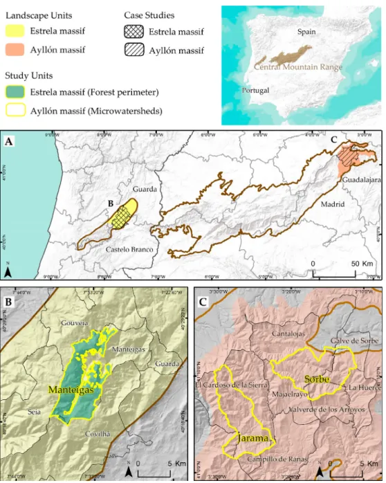
The Central Mountain System runs southwest/northeast for more than 500 kilometers and is about forty kilometers wide. It divides the Tagus and Douro River basins in the inland Iberian Peninsula, and includes several massifs. The selected case studies for the comparative analysis are located at either end of this natural region: The Estrela massif (Portugal) and the Ayllón massif (Spain) (Figure 1).
At the western end, the Estrela massif is granite and metamorphic glacial and periglacial land cover-ing about 287,500 hectares; its highest point is 1993 meters above sea level. Two valleys —Zêzere and Alforfa— shape the relief with steep slopes. Its climate is Mediterranean with dry-warm summers and annual mean temperatures around nine degrees. The wet season spans from October to May with annual mean precipitation of more than 2000 millimeters on the plateaus and 2500 millimeters in higher areas. The Estrela massif spreads into Guarda District (within five municipalities: Guarda, Manteigas, Gouveia, Seia, and Celorico da Beira) and Castelo Branco District, (municipality of Covilhã). In addition, the Zêzere basin falls within the Manteigas municipality located in the heart of the “U” shaped Zêzere glacier valley, and, currently, most of the Manteigas land is district-owned. A significant human footprint in this landscape led to deforestation cycles along with a strong boost for agricultural practices, culminating in a non-forest landscape (Baptista, 2010; Rego, 2001). Thenceforth, policies focused on afforestation plans, primarily to correct the hydrological regime in the nineteenth century (Devy-Vareta, 2003; Joanaz de Melo, 2017). The current landscape of this area and its floristic diversity are a product of long-term interaction between agriculture, grazing and fire (Connor et al., 2012; Rego, 1992; van der Knaap & van
Leeuwen, 1995; Vieira, Jansen, & Ferreira, 2005). Transitional woodland-shrubs, with particular empha-sis on broom species, dominate the land (Meneses, Reis, Vale, & Saraiva, 2015). The population in the Manteigas municipality never exceeded the 5400 people living there in the fifties and started declining in the sixties of the twentieth century (National Statistics Institute [INE] – Statistics Portugal, 1864–2001). Its settlements were mainly set up at lower altitudes to explore agriculture in a small farming system. Land at higher altitudes is not so fertile since it is mostly granitic, and agriculture is limited to a few crops such as rye and potatoes combined with pasture areas, and at even higher altitudes juniper shrubs and
matgrass grasslands dominate (Almeida, Nunes, & Figueiredo, 2009).
The Ayllón massif, located in the northeast of the Guadalajara province, with an area of 140,000 hectar-eas, comprises three Henares tributaries’ headwaters: Sorbe, Jarama and Bornova. The altitude ranges from about 700 to 2272 meters above sea level and slopes are steep. A sub-Mediterranean climate dominates and the micro and mesoclimate present considerable variations. In general, summers are fresh and winters are harsh. The wet season is at its most extreme in November and from January to March, with average precip-itation of 800 millimeters up to more than 1500 millimeters (Food and Agriculture Organization [FAO]). The southern side of this massif comprises four municipalities (Campillo de Ranas, El Cardoso de la Sierra, Majaelrayo and Valverde de los Arroyos) and features less farmed land areas because of the steepness of higher slopes. The north side of the massif includes six municipalities (Cantalojas, Campisábalos,
Conde-mios de Arriba, CondeConde-mios de Abajo, Galve de Sorbe and La Huerce) and provides richer forest resources. The Ayllón massif comprises other municipalities in the provinces of Segovia and Madrid (e.g., La Hiruela
in Madrid, and Cerezo de Arriba in Segovia), which were not be included in this study.
Figure 1. Case studies
Sources: Digital terrain model and boundaries – National Geographic Institute (Portugal, http://www.dgterritorio.pt and Spain, http://centrodedescargas.cnig.es)
2.2. Case Studies
Either end of the Central Mountain System presents dissimilar territorial and social background. Thus, the case studies have been selected based on two main assumptions: territorial specificity and
diversity on a local scale (socio-ecological features), and the evidence of fire footprint on the landscape (historical fire records). The national specificities and administrative constraints led to the selection of three study units using different criteria at the respective ends of the natural region (Figure 1): one in Estrela massif (delimited using public forest perimeters) and two in Ayllón massif (delimited using micro-watershed units). The public forest included in the Manteigas study unit, in the Estrela massif, includes
the five public forest areas in the municipality of Manteigas in the Guarda district, where the Manteigas forest perimeter is a pioneer in terms of protection and regulation of Portuguese public forests. In the Ayllón massif case study, two study units were selected (i.e., Sorbe and Jarama watersheds), which cover seven municipalities within the province of Guadalajara (Table 1). Municipalities were taken as the basic spatial unit for data collection, although in a multi-scale approach considering that the district, regional and national scale were applied for data processing and analysis. The total area of the Estrela massif case study is 58,000 hectares and the total area of the Ayllón massif case study is 63,000 hectares.
Table 1. Case studies
Landscape unit and Case
study
Study unit
Sub-units (Forest or Perimeter
for Estrela massif, and microwatershed
for Ayllón massif)
Administrative units considered
(Municipality and Parish (in parenthesis) for Estrela massif and municipality for Ayllón massif)
Estrela massif 1. Public Forests of Manteigas • Serra da Estrela (Nascentes do Zêzere) • Manteigas • Sameiro • Carvalheira • Souto do Concelho
• Manteigas (S. Pedro; Sameiro; Sta. Maria; Vale de Amoreira)
• Seia (Sabugueiro; Alvoco da Serra; Loriga) • Guarda (Valhelhas)
• Gouveia (União freg. Aldeias e Mangualde da Serra; Gouveia; Folgosinho)
• Covilhã (Erada; União freg. Covilhã e Canhoso; Cortes do Meio; Unhais da Serra; União freg. Cantar-Galo e Vila do Carvalho; Verdelhos) Ayllón massif 2. Sorbe microwatersheds • Sorbe • La Dehesa • Sorbe2 • Sonsaz • Galve de Sorbe • Cantalojas • Majaelrayo
• Valverde de los Arroyos • La Huerce 3. Jarama microwatersheds • Jarama • Berbellido • De las Canalejas • Berbellido2 • Campillo de Ranas • El Cardoso de la Sierra Own elaboration
2.3. Materials
The research resources used were geohistorical sources (documentary texts and historical cartogra-phy), and geospatial and statistical data. The documentary texts include administrative papers (i.e., the minutes of municipal council meetings, auction papers and other forest related reports), documents from legal proceedings (i.e., judicial accusations, police reports, applied fines, and court files) and documents providing information to the community (i.e., the regular newspaper and the official bulletin). These geohistorical data appear in four types of archives: historical archives (national, district/province, and municipal level), forest services and municipal archives, and libraries (traditional and electronic). In fact, documentary sources provided the basis to reconstruct the Fire History Dataset (FHD) for the inland regions of the Iberian Peninsula.
The FHD is an ongoing Access database developed by the Research Group on Forest Geography, Pol-icy and Socioeconomics of the Complutense University of Madrid, following the structure of the Spanish Statistic Fire Database (EGIF). Both EGIF and FHD are composed of several data fields, including infor-mation such as fire event attributes (ID —unique for each event and connected with a point shapefile with XY coordinates and the geolocation level—, date of fire event; starting location, fire duration, burned area in the original source unit and converted to hectares); territory features (landowner —state owned, public property, private property, or municipal owned—, economic and material losses, type and/or spe-cies of vegetation affected by the fire event); fire context (causes of fire —natural caused, negligence, acci-dental, intentional, rekindle, unknown cause, or not mentioned—, people and/or organizations involved in fire-fighting procedures and how the fire was suppressed); source type and characteristics (source/s and archive/s name/s with complete reference/s and person/people who collect the data); and other addi-tional explanatory remarks to better understand the event (Table 2).
Table 2. Used Materials – Geohistorical data
Type of Archives
Historical Forest services Municipal Libraries
Portugal
Ar
chives • Torre do Tombo National Archive
• Ministry of Agriculture Archive • ICNF Archives • Manteigas Municipal Archive • Portuguese National Library • ISA library Type of data
Information related to the municipality
Rural fire events and forest management documents
Fire use and rural fire events - Minutes of municipal
council meetings - Auction papers
- Other forest management documents
Rural fire events and forest management documents
Spain
Ar
chives
• National Historical Archive • Guadalajara Province
Historical Archive • Provincial Council Archive • Police Historical Archive
• Ministry of Agriculture Archive
Municipal Archive of: - Cantalojas - Galve de Sorbe - La Huerce
- Valverde de los Arroyos - Majaelrayo
- El Cardoso de la Sierra - Campillo de Ranas
• Spanish National Library • Spanish National electronic
newspaper database
Type of data
Fire use, Fire laws and Rural fire events
Rural fire events, Forest management plans and documents on Public Utility Forest (Protected forest areas)
Fire use and rural fire events - Minutes of municipal
council meetings - Auction papers
- Other forest management documents
Rural fire events
Own elaboration
Table 3. Used Materials – Historical cartography, spatial data and statistical data
Historical Cartography Spatial data Statistical data
Portugal
• Manteigas Afforestation Map (Format: Raster; Date of production: 1917; Scale: 1:5000) • Agricultural and Forestry
Map (Format: Raster; Date of production: 1910; Scale: 1:500 000) • Agricultural and Forestry
Map (Format: Raster; Date of production: 1968–1969; Scale: 1:250 000)
• First National Forest Inventory Map (Format: Vectorial; Date of production: 1965–1978; Scale: 1:25000; MCU: 2 ha)
• Portuguese Digital Terrain Model (30 meters) (Date of creation: 2009)
• Corine Land Cover Map 2000 (Format: Vectorial; Dates of production: 1999–2001; Scale: 1:100 000; MCU: 25 ha) • Portuguese Landscape Units
(Format: Vectorial; Date of creation: 1999–2002; Scale: 1:250000)
Population data:
• Portuguese Population Census (yr. 1877–2011 with medium interval of 10 years; Scale: national and municipality)
Forest management data:
• Portuguese General Census of Agriculture (yr. 1989, 1999 and 2009; Variables: Cattle units; Scale: municipality)
Meteorological data:
• FAO Climate database (from yr. 1961; Variables: Temperature and Precipitation)
Wildfire data:
• ICNF fire database (yr. 1980–2000; Municipality level)
• Fire perimeters from Landsat-based burnt area maps (extract yr. 1975–1979; One polygon per event) (Oliveira et al., 2012)
Spain
• Planimetries (Format: Raster; Date of production: 1895 and 1897; Scale: 1:25.000)
• Orthophoto (Format: Raster; Date of production: 1956 and 1957; Scale: 1:32.000)
• Spanish Digital Terrain Model (5 meters) (Date of creation: 2012; Date of update: 2017) • Corine Land Cover Map 2000
(Format: Vectorial; Dates of production: 1999–2001; Scale: 1:100 000; MCU: 25 ha) • Spanish Landscape Units
(Format: Vectorial; Date of creation: 2004; Scale: 1:1000000)
Population data:
• Spanish Population Census (yr. 1864–2011 with medium interval of 10 years; Scale: national and municipality)
Forest management data:
• Spanish Census of Agriculture (yr. 1999 and 2009; Variables: Cattle units; Scale: municipality) Meteorological data:
• AEMET database (yr. 1942–2000; Variables: Temperature and Precipitation)
Wildfire data:
• EGIF fire database (yr. 1968–2000; Province level from 1968–1983; Municipality level from 1983–1991; Coordinates from 1991–2000)
The geospatial data comprise land use cartography —three maps for the Portuguese case study, and two maps for the Spanish case studies, covering representative historical temporal periods— and the digital terrain model with maximum detail available for each country (thirty meters for Portugal and five meters for Spain). Finally, statistical data related to population, forest management and wildfires were collected from national census and databases at different institutions (Table 3).
In Portugal, the statistical fire data were obtained from the ICNF (Institute for Nature Conservation and Forests, Portugal) Fire Database and from the 1975–1979 database of wildfire perimeters produced within a national project (Oliveira, Pereira, & Carreiras, 2012). The EGIF has provided reliable information since 1968, although it has been evolving and its accuracy has improved over time (Vélez Muñoz, 2009).
Aiming to harmonize the different historical and statistical datasets in both countries, this research paper considered two different periods for comparative analysis: from 1751 to 1979 that was termed his-torical period, and from 1980 to 2000 that was termed statistical period.
2.4. Methods
This exploratory and analytical research was based on a geohistorical and geostatistical method, by gathering documentary sources in historical and administrative archives through a systematic and in-tensive two years work, and processing primary source data using Geographic Information Systems and Excel data integration techniques. A multiscale spatial and temporal analysis of the selected variables was also applied to reconstruct the FHD and the landscape dynamics in the case studies.
Temporal analysis considered two scales from the historical approach: long-term and medium-term (Brown, Kaufmann, & Shepperd, 1999; Moreno et al., 2014). The historical long-term perspective
encom-passes the last two centuries (nineteenth and twentieth centuries), and relates to the origin of the Liberal Regime and setting up the Forest Administration in Spain and Forest Regime in Portugal at the end of the nineteenth century. The medium-term perspective refers to the second half of the twentieth century and comprises more recent dynamics, affected by an economic transition and political constraints in both Portugal and Spain. This includes dictatorial regimes and the situation post-regime in both countries, the disarticulation of the traditional rural organization system due to the late industrial revolution and the urbanization and development processes, and the effects of the new rural policies as a consequence of the democratic reforms and entry into the European Union in 1986.
The multi-scale analysis also implies four spatial scales: national, regional (Central Mountain System natural region), intermediate (Estrela and Ayllón massifs) and local (municipalities).
3. Results
3.1. Reconstruction of fire history
Even though fire statistics only started in the second half of the twentieth century for both Portugal and Spain, it was possible to reconstruct the fire history for both ends of the Central Mountain System from 1768 to 1979 using geohistorical sources —1925 to 1979 for the Estrela massif and 1978 to 1979 for the Ayllón massif (Table 4)—. Most of the information was obtained from administrative documents gathered in the forest services and historical archives, while municipal archives just provided records for the Ayllón massif (Figure 2). In fact, documentary sources rarely report wildfires prior to the twentieth century in Portugal (Figure 3), which does not mean that fire was not present in the territory. Instead, it is possible that some fires were not recorded because they did not represent significant socioeconomical losses at the local scale (Montiel-Molina, 2013b).
Table 4. Number of fire records for each type of archive
Type of Archives
Total Historical Forest services Municipal Libraries
Century 18th 19th 20th 18th 19th 20th 18th 19th 20th 18th 19th 20th
Estrela massif – – 25 – – 28 – – – – – 30 83
Ayllón massif 1 – 14 – 16 1 1 4 11 – 10 3 61
Total 40 45 16 43 144
Figure 2. Cantalojas Municipality record of an auction of 22 timber pine trees from a rural fire occurred on August 6, 1867 at Monte Pinar
Source: Cantalojas Municipal Archive, File “Documents 1870–1893”. Credits: Authors, 2016
Figure 3. Record of a rural fire of 1967 in Manteigas. In the upper section, the details of the fire are described, and in the bottom section, the characteristics of the fire are drawn and explained, including the monetary damages
and the trees characteristics
The Estrela massif is considered to be one of the most fire-prone areas in Portugal (Connor et al., 2012;
van der Knaap & van Leeuwen, 1995). From the second half of the twentieth century onward, the number of wildfires frequently exceeded its average number for the complete historical period. Even if the accepted shift for the Portuguese fire regime came in the nineteen seventies (Ferreira-Leite, Bento-Gonçalves, Lourenço, Úbeda, & Vieira, 2013), this took place one decade earlier in the Estrela massif, where 1961 and 1967 were critical years in terms of ignitions. Furthermore, large wildfires have mainly been recorded since 1967, when three wildfires burned more than 700 hectares of pine stands and shrubland in the Covilhã municipality. In the Ayllón massif, there is a similar temporal pattern for burned surface area, with two exceptional years in 1970 and 1978, when two and three wildfires burned more than 900 and 700 hectares respectively, but fire occurrence is higher at the end of the nineteenth and beginning of the twentieth centuries. Consequently, the first pyrotransition was only evident at the eastern end of the Central Mountain System, and the second one was stronger in the western end (Figure 4).
Figure 4. Number of fires (A) and burned area (B) in the period 1751–1979 (Estrela and Ayllón massifs)
Sources: Complutense University of Madrid FHD. Own elaboration
In Estrela, most of the burned area was pine stands (particularly Pinus pinaster) and shrubland, and
the majority of the burned stands were between ten and sixty years old. In Ayllón, the type of vegetation affected was slightly different, since it was shrubland and pasture vegetation above all, plus afforestation pines and oaks. The majority of losses were reported in terms of money, demonstrating that, in both massifs, it was not always the fire events with the most burned area that represented the greatest financial burden. In addition, it should be noted that the highest reported losses were particularly on public prop-erty, partly because these properties were managed by the forest administration following cost-effective forest planning management.
During the statistical period (1980–2000), fire records were quite different at either end of the Cen-tral Mountain System. In comparison with the 1731 wildfires recorded in the Estrela massif, only 123 wildfires were recorded in the Ayllón massif, and the average burned area was much higher in the Estrela massif than in the Ayllón massif. The annual evolution also differed in both areas. In the Estrela massif, there was an initial peak in the number of fires in 1985 and then others peaks took place (Figure 5).
Figure 5. Number of fires in the period 1980–2000 in Estrela massif (A) and in Ayllón massif (B)
Sources: EGIF and ICNF Fire database. Own elaboration
The ignitions trend in the Ayllón massif is more irregular and the surface area burned is non-significant, except for 1986 and 1991 when the large wildfires recorded two maximums, both one year after similar maximums in the Estrela massif peaks (Figure 6).
Figure 6. Burned area in the period 1980–2000 (Estrela and Ayllón massifs)
Sources: EGIF and ICNF Fire database. Own elaboration
The causes of fire changed significantly between the historical and the statistical period at both ends of the Central Mountain System. In the Estrela massif, most historical wildfires were intentional or due to negligent use of fire. A small proportion of fires stemmed from natural causes or burning activities for pasture renewal, agriculture or forest activities (Figure 7).
On the contrary, after 1980, pastoralism, agriculture or forest activities were the dominant cause of wildfires above all the rest, as was the case throughout the Guarda District (Lourenço et al., 2013). In
Ayllón, the main causes of wildfire were the use of fire in burning activities for pasture renewal, agricul-ture and forest activities, and negligence. This area was also characterized by a high number of natural wildfires, i.e., lightning. In turn, in the Estrela massif the larger number of fire ignitions were caused by
humans. However, the most remarkable aspect is that wildfires related to fire use for rural activities de-creased and intentional wildfires started playing a stronger role during the statistical period at the eastern end of the Central Mountain System, just the opposite to the western end. The main reasons for this contrast are socio-ecological contexts and national regulations.
Figure 7. Causes of fire in the two ends of the Central Mountain System in the periods 1751–1979 and 1980–2000
Sources: Complutense University of Madrid FHD. Own elaboration
3.2. Historical fire scenarios: the influence of contextual factors on fire occurrence through
history
A historical fire scenario is a set of historical landscape drivers of wildfire, i.e., the past territorial dynamics that contextualize their contemporaneous fire regimes. The contextual factors analyzed in this paper are land use, population, and land management practices.
The general land use trend in the Estrela massif and in the Ayllón massif since the end of the nine-teenth century has seen forest area progressing against shrubland and pastures, although featuring some local particularities (Figure 8).
Figure 8. Land use changes in Estrela massif (A) and in Ayllón massif (B) from various sources
In the case of Manteigas, it has been strongly influenced by the first afforestation plan implemented since the transfer of the land to the National Forest Service in 1880, and also since the law on Forest Regime came into force in 1901, which focused more on hydrological and soil conservation issues. Fur-thermore, the Afforestation Plan campaign of the New Regime (1938) led to completely occupying land either for crops or for afforestation purposes. Nevertheless, a few decades later, the relationship between rural society and territory changed. Agriculture lost its relevance in the Portuguese economy and society and the traditional rural organization system was transformed (Figure 9). This brought rural abandon-ment (less cultivated land, and less working population) (Baptista, 2010; Fernández & Corbelle, 2017), which led to a higher accumulation of fuels in forests. This, together with the previous monospecific af-forestation campaign, favored the spread of wildfires (Oliveira, Guiomar, Baptista, Pereira, & Claro, 2017; Rego, 2001). After this shift (Torres, Pérez, Quesada, Viedma, & Moreno, 2016), agricultural production and productivity increased because of technological advances, and agricultural statistics show that the number of farms increased from 1989 to 1999, alongside the farming community, that was still more focused on animal production. Nevertheless, as the results show, the number of fires increased as well as the number of years that had unexpected fire events.
Figure 9. Two photographs of the surroundings of Manteigas town, at the glacial valley of the river Zezere, Estrela massif, at different times. Pine trees at the hills and agricultural structures close to the town can be seen, much more agricultural
areas in the first photograph
Source: (A) Photograph Service of the O Século Journal, Album nr 194, dates between years 1921 and 1928. Torre do Tombo National Archive, Digiarq, PT/TT/EPJS/SF/001-001/0194/A0061; (B) Credits: Authors, 2017
In the Sorbe and Jarama case studies, in the fourteenth century (in Alfonso XI’s third book or Libro de Monteria) forest wildlife was abundant and Sorbe was referred to as wild bear and wild pig territory.
However, later in the second half of the sixteenth century (in Felipe II’s Relaciones Topograficas), few
forests were mentioned and the vast majority were turned into pastures, largely due to the increasingly powerful Mesta (nationwide association of sheep ranchers in the Crown of Castille land that lasted until
the beginning of the nineteenth century) requirements and their incompatibility with large forests. In the eighteenth century, the area was heavily deforested, and most of the forest was turned into communal wastelands for grazing. Pines were more abundant in the Galve de Sorbe area than in the rest of the area, according to the Catastro de Ensenada (land registry). In the nineteenth century, and according to the
Ma-doz’s Geographic, Statistical and Historical Dictionary of Spain, there were pines, heaths and shrubs, and wood was extracted for domestic use, commerce (charcoal to supply Madrid), and other purposes (Her-nando & Madrazo, 2016). The greatest degradation of forests occurred with the disentailment process because this involved extensive logging to make them suitable as farmland, which increased the number of fires (Iriarte-Goñi & Ayuda, 2018; Vadell, de-Miguel, & Pemán, 2016). This last period corresponds to setting up the Forest Administration in Spain, when protection and custody processes began for the towns and local authorities’ forested land. In terms of laws, it appeared in the First Forest Law of 1863 and its first reform in 1957 and other subsequent reforms once in the twenty-first century.
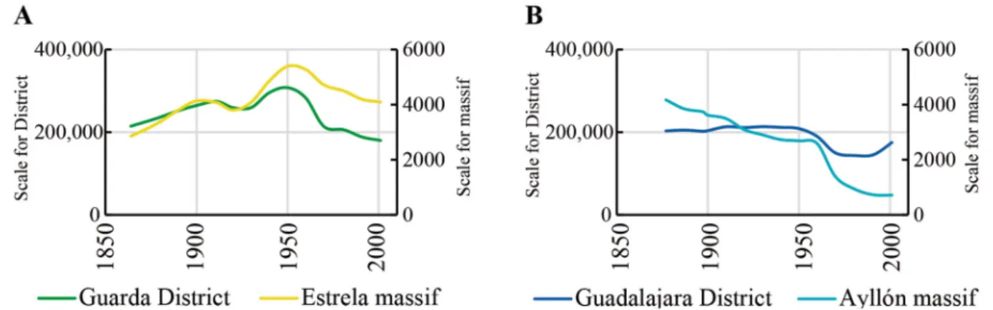
The population at either end of the Central Mountain System increased in the twelfth century, coin-ciding with the construction of monasteries and castles for protection against Muslims and Arabs. Nev-ertheless, from the second half of the nineteenth century, population has always been scarce by district/ province standards (Figure 10).
Figure 10. Number of inhabitants in Estrela massif (A) and in Ayllón massif (B)
Source: Portuguese population census (INE, Portugal) and Spanish population census (INE, Spain). Own elaboration
In Portugal, statistics show that the average number of inhabitants in Manteigas has always been low and the downward trend in population growth after the sixties followed the same trend as the District of Guarda. In the Ayllón massif, growth trends did not always follow the Province of Guadalajara. The popu-lation in the Province rose after 1981, due to the metropolitan dynamics of the urban region of Madrid, but in the massif, population growth moved against this trend, even though some municipalities were annexed in 1970 and 1981, which increased the number of inhabitants. In both cases, population declined most numerically in the sixties, seventies and part of the eighties due to emigration processes and rural exodus (Galvão & Devy-Vareta, 2010; Paniagua & Hoggart, 2001), which coincide with the increase in burned area.
At both ends of the Central Mountain System, local societies are rural mountain communities, which lived off subsistence farming (cultivation of cereals and potatoes), raising livestock and of the transhu-mance of wool livestock, although the latter was much more important in Spain than in Portugal. In the Estrela massif, the grazing system of transhumance (i.e., migratory herding) for wool production lasted until the beginning of the twentieth century from the Estrela massif in summer to the Alentejo area in winter. After that, there was still transhumance but confined to the mountain area and the core pro-duction switched to traditional sheep’s cheese where the average propro-duction property was a small-scale family milk production facility (Martinho, 1981). Livestock units were abundant in Manteigas through the nineteenth century, reaching a peak at the end of the nineteenth century boasting more than 16,000 units (Figure 11).
Figure 11. Livestock (annual number of sheep and goats) in Estrela massif
Sources: Manteigas municipal archive (annual cattle units) and Portuguese general census of agriculture (INE, Portugal). Own elaboration
In the twentieth century there was a steep decline in number of livestock, except for 1955, and sheep always outnumbered goats, and still do. Once the Manteigas Forest Perimeter was created (1888) and the Forest Service began the afforestation campaigns, grazing activities began to decline as logging increased (Figure 12).
Figure 12. Changes in forest uses in Estrela massif (A) and in Ayllón massif (B)
Sources: Municipal archives of Estrela and Ayllón massifs (Table 2) - forest management documents. Own elaboration
This is also supported by records of complaints by several shepherds found in the minutes of mu-nicipal council meetings from that period, in which is said that the grazing fields had become fewer and smaller since reforestation had begun (Manteigas Municipal Council, 1885–1895).
In the Ayllón massif, agriculture (mostly cereal production, namely rye) played a secondary role com-pared to the livestock activities, especially because the cultivated lands were clayey and stony and pro-duction was small in scale, mostly in the more fertile lands (Gómez Mendoza, 1967). Regarding livestock, in the Ayllón massif, and as opposed to the current situation where cows are very numerous, sheep and goats have dominated this rural economy since pre-Roman times, when the large flocks travelled from this area to Andalucía and Extremadura. From the thirties onwards, the number of cows in Ayllón has been increasing, due to a growing trend in open-range livestock grazing for meat production. Goat units decreased significantly, partly due to imposing rural development plans in the sixties. Since this system
focuses on grazing activities, the vast number of complaints found from the twentieth century onwards are related to grazing. Before 1930, sheep and goats were much more abundant in the upper Sorbe (Can-talojas and Galve de Sorbe municipalities) and numbers started decreasing at the end of the forties.
Concerning land tenure, the vast majority of the land was communal and had practically no wage labor in both mountain areas. In the Ayllón massif, at the beginning of the fifteenth century, some forests of the sexmo of Transierra were property of the Community of the Town and Land of Ayllón (a very
im-portant key element in management of the territory), and half a century later, they belonged to the Mar-quis of Villena, Lord of Ayllón. According to the Proyecto de Ordenación del MUP de los propios de Galve in
1954, there is also evidence of part of this territory belonging to Galve County, bounded with the House of Alba and vague references to a religious order that had possibly been subject to the disentailment process. In any case, they maintained the same type of management authority until the disentailment processes began, when the old feudal system became obsolete and was replaced by a municipal management sys-tem, with its Public Utility Forest figure. A comparable process happened in Portugal by means of the legal figure of Forest Perimeters after 1888, when the Forest Service began to take a prime role in forest management.
Finally, the political focus in Manteigas on timber and fuel wood and the rural exodus had made it impossible to maintain the traditional rural livestock system and this is directly related to the fire history. In Ayllón, the traditional rural system had changed in scale but continued to maintain its structure, which enabled a more controlled rise in wildfire-burned area, despite the very pronounced rural exodus that also took place (Figure 13).
Figure 13. Photograph of the surroundings of La Huerce town, municipality of La Huerce, Ayllón massif, which is extremely depopulated. The three layers are seen: tree canopy layer (pine tree afforestation, in green), shrubland layer (in
red), and ground layer (in orange)
Credits: Authors, 2017
4. Discussion
The results obtained show that the evolution of the fire regime in the Central Mountain System during the nineteenth and twentieth centuries was non-linear. On a regional scale, there were two important pyrotransitions: the first at the end of the eighteenth century/beginning of the nineteenth century, when both the number of fires and burned area increased significantly; and a second in the middle of the twentieth century, when large wildfires also became more frequent (Araque Jiménez et al., 1999;
Montiel-Molina, 2013b), highlighting the mismatch between the fire regime and the landscape dynamics (Silva, Rego, Fernandes, & Rigolot, 2010). In fact, due to differences in landscape character and dynamics, a certain time lag and specific features for the second pyrotransition can be seen at a local scale at both ends of this mountainous region (Table 5).
Table 5. Pyrotransitions in Estrela and Ayllón massifs
Massif Pyrotransitions and their characteristics
19th century 20th century
Estrela
Throughout the 1960s:
- Increase of the number of fires from the beginning of the decade - Increase of burned area at the end of
the decade
The middle 1980s:
- Increase of the number of fires - Uncertainty
Ayllón
End of the 19th century:
- Increase of the number of fires
The 1970s:
- Increase of burned area
The middle 1980s:
- Increase of the number of fires - Uncertainty
Own elaboration
According to these fire regime changes and considering that fire causes are directly related to so-cioeconomic organization and resource management and protection systems (Montiel-Molina, 2013a), three different stages in the fire regime evolution have been identified in the Estrela and Ayllón massifs throughout the nineteenth and twentieth centuries: (a) before the pyrotransition of the end of the nine-teenth century; (b) the first half of the twentieth century, until the second pyrotransition; and (c) the second half of the twentieth century, when another change of fire regime was foreseen in the mid-eighties because of growing uncertainty.
Land use features and socio-spatial structure had a relevant influence on fire regime evolution in each place (Beilin & Reid, 2015; Cabana Iglesia, 2007; Lambin & Meyfroidt, 2010). Actually, one of the main influencing factors is the land management system and its impact on the state of natural resources. Maintenance of pastures for wool production was key to fuel reduction in the Estrela and Ayllón massifs for centuries. However, the decline of this economic sector in the Estrela massif at the beginning of the twentieth century (Marques, 2006) and the subsequent abandoning of pastures led to the progressive accumulation of fuel, in contrast with the situation in the Ayllón massif, where the ongoing grazing activ-ities implied a lower wildfire propagation risk. The increase in the number of fires caused by burnings in Estrela after 1980 demonstrates poor adaptation of the new communities to old traditional farming and grazing activities, which did not happen in the Ayllón massif. In the Ayllón massif, despite the acknowl-edged changes, rural society was able to maintain its farming system of open-range livestock grazing and consolidate the forestry sector. This was possible because, regardless of changes in land ownership that came with the disentailments (which had social, economic, cultural and ecologic consequences), the majority were able to maintain their communal character. As such, despite the low index of human occu-pation and conflicts among inhabitants, forest management significantly reduced the historical incidence of fires in the Ayllón massif compared to its regional context. In Manteigas, the successive regulatory frameworks from the late nineteenth century that changed its landscape dynamics resulted in conflicts between the inhabitants, local power and the Forest Services due to insufficient pasture areas, as well as a high number of fines for forest infractions.
Landscape changes are related to socioeconomic and political history (Moreira, Rego, & Ferreira, 2001), and indeed the case studies demonstrate that the change in fire scenarios led to a shift in the fire
regime. Just before each identified pyrotransition the system was disrupted (imbalance of the contextual factors that compounded the rural system: land use, population and forest management). Such disruptive events gave way to a new fire regime (rise in the number of fires and burned area, and especially cata-strophic fire events) that stabilized for a period, until the next fire scenario began. In fact, other studies from the Geography discipline in different areas of the Iberian Peninsula confirmed the disruption of the traditional rural system from the mid-twentieth century. That is the case of Cantabria and Galicia, where additionally was confirmed the effect of that disruption in the increase of fire frequency and also in the increase of the number of fires motivated by conflicts (Cabana Iglesia, 2009; Carracedo Martín, 2015). At
this point, it is fair to say that human factors carried more weight in fire regimes at both ends of the Cen-tral Mountain System than environmental factors, like topography, soil features, weather conditions and build up of fuel. Nevertheless, the contextual factor that triggered the change differed between the two case studies: in Estrela, population was demonstrated to be the factor that was controlling the local rural system and once it decreased, the system, as it was, began to collapse. In Ayllón, the contextual factor that kept the system going was the rural land use practices, and they were maintained.
5. Conclusions
The reconstruction of the fire history and the analysis of the contextual factors at the local level have allowed us to verify the hypothesis that relates any disruption within the social-ecological system with an abrupt shift in fire regime in the inner mountain areas of the Iberian Peninsula. However, we found that the influence of human factors was stronger than environmental differences to explain the changes in wildfire risk at the two ends of the Central Mountain System during the last two centuries. Despite sharing characteristics as part of the same mountain region, the Estrela and Ayllón massifs present different features such as their size, dissimilar range of altitude, and different annual precipitation. Nevertheless, the socio-economic and political contexts on their own were definitely enough to generate different fire regimes as well as distinct associated human causes of wildfires during the nineteenth and twentieth centuries.
The relationship between fire regimes and landscape structure dynamics (fire scenarios: land use, pop-ulation and forest management) brought about the main fire regime changes throughout the nineteenth and twentieth centuries. In fact, before the second pyrotransition, fire was a well-integrated element of the rural landscapes serving as a land management tool. After the general disarticulation of the traditional rural system, taking place at both ends of the Central Mountain System at different times according to the contextual factors on the local scale, the fire regime stepped up to a wildfire regime, leading not only to an increase in fire occurrence, but also to a larger burned area and to a great deal of uncertainty. If fire caus-es had mainly been related to rural activiticaus-es previously, after the middle of the twentieth century they started being linked to social and economic development and the change of lifestyle in both countries. The depopulation and associated abandonment of traditional land management practices from the sixties
in Manteigas resulted in a structural imbalance associated with human-caused wildfires. In this case, fire has turned out to be a landscape degradation factor. On the contrary, despite the pronounced population decline after the second pyrotransition in the Ayllón massif, maintenance of land management and cul-tural heritage have created a more resilient landscape to wildfire risk. At present, its historical dynamics must be understood to raise awareness of the fire risk policies dealing with the driving forces of landscape change (Antrop, 2005; Connor et al., 2012; Seijo et al., 2015). In fact, the close relationship between the
components of this traditional local rural system (people, livestock and vegetation) should definitely be further explored to formulate and implement fire management policies for the future (Canadas, Novais, & Marques, 2016; Fernandes, Guiomar, Mateus, & Oliveira, 2017).
2017 was a catastrophic year of wildfires in the Iberian Peninsula (Comissão Técnica Independen-te, 2017), and in the twenty-first century Portugal and Spain are considered to be the first and second southern European countries most affected by fires (European Commission, 2017). In that context, this geohistorical approach, which can be applied wherever there is documented historical fire records, proves to be a suitable and added contribution to incorporate lessons learnt from the long-term fire history into current and future wildfire scenario challenges (Carracedo Martín et al., 2017).
Funding
This work was funded by the Spanish Ministry of Economy and Competitiviness [National Project I+D+i FIRESCAPE CSO2013-44144-P]; and the Ministry of Science and Innovation [grant number FPI BES-2014-068696]. It was developed as part of a PhD in Geography in the Research Group on Forest Geography, Policy and Socioeconomics at the Complutense University of Madrid.
Acknowledgments
We would like to thank the mayor and officers of all municipalities in the study, as well as the local forest rangers for all the information they provided and the time they spent with us.
References
Abel-Schaad, D., & López-Sáez, J. A. (2013). Vegetation changes in relation to fire history and human activities at the Peña Negra mire (Bejar Range, Iberian Central Mountain System, Spain) during the past 4,000 years. Vegetation History and Archaeobotany, 22(3), 199–214. https://doi.org/10.1007/ s00334-012-0368-9
Almeida, A. C., Nunes, A., & Figueiredo, A. (2009). Mudanças no uso do solo no interior Centro e Norte de Portugal. https://doi.org/10.14195/978-989-26-0366-7
Antrop, M. (2005). Why landscapes of the past are important for the future. Landscape and Urban Planning, 70(1–2), 21–34. https://doi.org/10.1016/j.landurbplan.2003.10.002
Araque Jiménez, E., Vélez Muñoz, R., Gómez Mendoza, J., Valdes, C. M., Fernández Muñoz, S., Guitián Rivera, L., … Pyne, S. J. (1999). Incendios históricos. Una aproximación multi-disciplinar. (E. Araque
Jiménez, Ed.). Baeza: Universidad Internacional de Andalucía.
Badia, A., Pèlachs, A., Vera, A., Tulla, A. F., & Soriano, J. M. (2014). Cambios en los usos y cubiertas del suelo y vulnerabilidad en las comarcas de montaña de Cataluña. Del rol del fuego como herramienta de gestión a los incendios como amenaza. Pirineos. Revista de Ecología de Montaña, 169, e001. https:// doi.org/10.3989/Pirineos.2014.169001
Baptista, F. O. (2010). O Espaço Rural - Declínio da Agricultura (1st ed.). Lisboa: Celta.
Beilin, R., & Reid, K. (2015). It’s not a ‘thing’ but a ‘place’: reconceptualising ‘assets’ in the context of fire risk landscapes. International Journal of Wildland Fire, 24(1), 130–137. https://doi.org/http://dx.doi. org/10.1071/WF14035
Brown, P. M., Kaufmann, M. R., & Shepperd, W. D. (1999). Long-term landscape patterns of past fire events in a montane Ponderosa pine forest of Central Colorado. Landscape Ecology, 14, 513–532. https://doi.org/10.1023/A:1008137005355
Cabana Iglesia, A. (2007). Los incendios en el monte comunal gallego. Lugo durante el primer franquismo.
Historia Agraria, 43, 555–557.
Cabana Iglesia, A. (2009). A cultura de fuego en los montes gallegos. Aproximación a una relación histórica. Recursos Rurais.Revista oficial do IBADER, 5, 101–106.
Camarero, J. J., Sangüesa-Barreda, G., Montiel-Molina, C., Seijo, F., & López-Sáez, J. A. (2018). Past growth suppressions as proxies of fire incidence in relict Mediterranean black pine forests. Forest Ecology and Management, 413, 9–20. https://doi.org/10.1016/j.foreco.2018.01.046
Canadas, M. J., Novais, A., & Marques, M. (2016). Wildfires, forest management and landowners’ collective action: A comparative approach at the local level. Land Use Policy, 56, 179–188. https://doi. org/10.1016/j.landusepol.2016.04.035
Carracedo Martín, V., Cunill Artigas, R., García Codron, J. C., Soriano López, J. M., Pèlachs Mañosa, A., & Pérez Obiol, R. (2017). Fuentes para la geografía histórica de los incendios forestales. Algunas consideraciones metodológicas. Cuadernos Geográficos, 56(3), 66–89.
Carracedo Martín, V. (2015). Incendios forestales y gestión del fuego en Cantabria (Tesis doctoral).
Universidad de Cantabria. Santander.
Castellnou, M., Miralles, M., & Molina, D. (2009). Patrones de propagación de incendios forestales y su uso para la planificación. In R. Vélez Muñoz (Ed.), Incendios Forestales: Fundamentos y Aplicaciones
(pp. 274–282). McGraw-Hill.
Comissão Técnica Independente. (2017). Análise e apuramento dos factos relativos aos incêndios que ocorreram em Pedrogão Grande, Castanheira de Pera, Ansião, Alvaiázere, Figueiró dos Vinhos, Arganil, Góis, Penela, Pampilhosa da Serra, Oleiros e Sertã, entre 17 e 24 de junho de 2017. Lisboa: Assembleia
da República.
Connor, S. E., Araújo, J., van der Knaap, W. O., & van Leeuwen, J. F. N. (2012). A long-term perspective on biomass burning in the Serra da Estrela, Portugal. Quaternary Science Reviews, 124(55), 114–124. https://doi.org/10.1016/j.quascirev.2012.08.007
Costa, P., Castellnou, M., Larrañaga, A., Miralles, M., & Kraus, D. (2011). La Prevención de los grandes incendios forestales adaptada al incendio tipo. (J. Vendrell, E. Nebot, M. Borrás, & H. Ballart, Eds.).
Barcelona: Unitat Tècnica del GRAF.
Devy-Vareta, N. (2003). O Regime Florestal em Portugal através do século XX (1903-2003). Revista Da Faculdade de Letras - Geografia, XIX, 447–455.
European Commission. (2017). Forest Fires in Europe, Middle East and North Africa 2016 - Scientific and Technical Research Series - JRC Technical Reports. https://doi.org/10.2760/17690
Fernandes, P.M., Loureiro, C., Guiomar, N., Pezzatti, G.B., Manso, F.T. & Lopes, L. (2014). The dynamics and drivers of fuel and fire in the Portuguese public forest. Journal of Environmental Management, 146,
373-382. https://doi.org/10.1016/j.jenvman.2014.07.049
Fernandes, P. M., Guiomar, N., Mateus, P., & Oliveira, T. (2017). On the reactive nature of forest fire-related legislation in Portugal: A comment on Mourão and Martinho (2016). Land Use Policy, 60,
12–15. https://doi.org/10.1016/j.landusepol.2016.10.008
Fernández, D., & Corbelle, E. (2017). Cambios en los usos de suelo en la Península Ibérica: un meta-análisis para el período 1985-2015. Revista Bibliográfica de Geografía y Ciencias Sociales, 21(1), 215.
Ferreira-Leite, F., Bento-Gonçalves, A., Lourenço, L., Úbeda, X., & Vieira, A. (2013). Grandes Incêndios Florestais em Portugal Continental como resultado das perturbações nos regimes de fogo no mundo Mediterrâneo. Silva Lusitana, 21(Especial), 129–144.
Food and Agriculture Organization (FAO). FAO Climate database, 1961-2015.
Franco Múgica, F., García Antón, M., Maldonado Ruiz, J., Morla Juaristi, C., & Sainz Ollero, H. (2001). Evolución de la vegetación en el sector septentrional del macizo de Ayllón (Sistema Central). Análisis polínico de la turbera de Pelagallinas. Anales Del Jardín Botánico de Madrid, 59(1), 113–124. https:// doi.org/10.3989/ajbm.2001.v59.i1.102
Franco Múgica, F., García Antón, M., & Sainz Ollero, H. (1998). Vegetation dynamics and human impact in the Sierra de Guadarrama, Central System, Spain. The Holocene, 8(1), 69–82. https://doi. org/10.1191/095968398675691171
Galvão, M. J., & Devy-Vareta, N. (2010). A multifuncionalidade das paisagens rurais: uma ferramenta para o desenvolvimento. In Cadernos do Curso de Doutoramento em Geografia (pp. 61–86). Porto:
Faculdade de Letras da Universidade do Porto.
Ganteaume, A., Camia, A., Jappiot, M., San-Miguel-Ayanz, J., Long-Fournel, M., & Lampin, C. (2013). A Review of the main driving factors of Forest Fire ignition over Europe. Environmental Management, 51(3), 651–662. https://doi.org/10.1007/s00267-012-9961-z
Gil García, M. J. (1992). Dinámica de la paleovegetación en el sector oriental del Sistema Central Español durante el Holoceno, en base al análisis polínico. Implicaciones climáticas. Madrid: Universidad de
Alcalá de Henares.
Gómez Mendoza, J. (1967). La venta de baldios y comunales en el siglo XVI. Estudio de su proceso en Guadalajara. Estudios Geograficos, 28(109), 499.
Hernandez Vera, T., & Ruiz Zapata, B. (1984). Datos preliminares de los analisis polinicos de las tollas ubicadas en Galve de Sorbe (Guadalajara). Anales Asociación Palinólogos de Lengua Española, (1),
71–76. Recuperado de http://hdl.handle.net/10396/8427
Hernando, J., & Madrazo, G. (2016). Firewood and Charcoal Consumption in Madrid during Eighteenth Century and Its Effects on Forest Landscapes. In Springer (Ed.), Environmental History in the Making
(pp. 321–340). https://doi.org/10.1007/978-3-319-41085-2_18
Iriarte-Goñi, I., & Ayuda, M.-I. (2018). Should Forest Transition Theory include effects on forest fires? The case of Spain in the second half of the twentieth century. Land Use Policy, 76, 789–797. https:// doi.org/10.1016/j.landusepol.2018.03.009
Janssen, C. R., & Woldringh, R. E. (1981). A preliminary radiocarbon dated pollen sequence from the Serra da Estrela, Portugal. Finisterra, 16(32), 299–309. https://doi.org/10.18055/Finis2176
Joanaz de Melo, C. (2017). Arborizar contra cheias, tempestades e marés 1834-1886 - Políticas de águas e de florestas em Portugal. Lisboa: Instituto de Arqueologia e Paleociências (UNL) e Instituto de História
Lambin, E. F., & Meyfroidt, P. (2010). Land use transitions: Socio-ecological feedback versus socio-economic change. Land Use Policy, 27(2), 108–118. https://doi.org/10.1016/j.landusepol.2009.09.003
Leone, V., Lovreglio, R., & Martínez-Fernandéz, J. (2002). Forest fires and anthropogenic influences. A study case (Gargano National Park, Italy). In D. Viegas (Ed.), IV International Conference on Forest Fire Research & Wildland Fire Safety Summit (p. 17). Rotterdam: Millpress Science Publishers.
López-Merino, L., López-Sáez, J. A., Alba-Sánchez, F., Pérez-Díaz, S., & Carrión, J. S. (2009). 2000 years of pastoralism and fire shaping high-altitude vegetation of Sierra de Gredos in central Spain. Review of Palaeobotany and Palynology, 158, 42–51. https://doi.org/10.1016/j.revpalbo.2009.07.003
López-Sáez, J. A., Abel-Schaad, D., Luelmo-Lautenschlaeger, R., Robles-López, S., Pérez-Díaz, S., Alba-Sánchez, F., … Gavilán, R. G. (2018). Resilience, vulnerability and conservation strategies in high-mountain pine forests in the gredos range, central spain. Plant Ecology and Diversity, 11(1), 97–110. https://doi.org/10.1080/17550874.2018.1449261
López-Saéz, J. A., Abel-Schaad, D., Pérez-Díaz, S., Blanco-González, A., Alba-Sánchez, F., Dorado, M., … Franco Múgica, F. (2014). Vegetation history, climate and human impact in the Spanish Central
System over the last 9000 years. Quaternary International, 353(December), 98–122. https://doi.org/ https://doi.org/10.1016/j.quaint.2013.06.034
López-Sáez, J. A., Vargas, G., Ruiz-Fernández, J., Blarquez, O., Alba-Sánchez, F., Oliva, M., Pérez-Díaz, S., Robles-López, S., Abel-Schaad, D. (2018). Paleofire dynamics in Central Spain during the Late Holocene: The role of climatic and anthropogenic forcing. Land Degradation and Development, 29(7),
2045–2059. https://doi.org/10.1002/ldr.2751
López García, P. (1978). Resultados polínicos del Holoceno en la Península Ibérica. Trabajos de Prehistoria, 35, 9–44.
López Gómez, A. (1980). Los bosques de la serrania de Atienza en el s. XVIII. Wad-Al-Hayara: Revista de Estudios de Guadalajara, 7, 369–378.
Lourenço, L., Fernandes, S., Nunes, A., Gonçalves, A. B., & Vieira, A. (2013). Determination of forest fire causes in Portugal (1996-2010). Flamma, 4(3), 171–175.
Lourenço, L., & Malta, P. (1993). Elementos estatísticos - Incêndios florestais em Portugal Continental na década de 80 e anos seguintes. Finisterra, XXVIII(55–56), 261–277.
Macedo, F. W., & Sardinha, A. M. (1987). Fogos Florestais. Lisboa, Portugal: Publicações Ciência e Vida, Lda.
Magalhães, S. R., Ribeiro, C. A., Castro, J. M., Fernandes, P., Silva, C. A., Pinheiro, H., & Azevedo, J. C. (2017). Comportamento do fogo em diferentes períodos e configuracoes de uma paisagem no Nordeste de Portugal. Ciência Florestal, Santa Maria, 27(2), 457–469. https://doi.org/10.5902/1980509827728
Manteigas Municipal Council. (1885–1895). Manteigas Municipal Council Meeting Books. Manteigas,
Portugal.
Marques, P. P. (2006). Serra da Estrela: Gestão e Conservação de Habitats Prioritários - Projecto LIFE Natureza (LIFE02/NAT/P/8478). Tortosendo: Associação de Produtores Florestais do Paul.
Martínez-Fernandéz, J., Vega-garcía, C., & Chuvieco, E. (2008). Human-caused wildfire risk rating for prevention planning in Spain. Journal of Environmental Management, 90, 1241–1252. https://doi. org/10.1016/j.jenvman.2008.07.005
Martinho, A. T. (1981). O pastoreio e o queijo da Serra. (SNPRPP, Ed.) (2a edição). Seia: Serviço Nacional
de Parques Reservas e Património Paisagístico.
Meneses, B. M., Reis, R., Vale, M. J., & Saraiva, R. (2015). Land use and land cover changes in Zêzere watershed (Portugal) - Water quality implications. Science of the Total Environment, 527–528, 439–447. https://doi.org/10.1016/j.scitotenv.2015.04.092
Meneses, B., Reis, E., & Reis, R. (2018). Assessment of the recurrence interval of wildfires in mainland Portugal and affected LUC patterns identification. Journal of Maps, 14(2), 282–292. https://doi.org/1 0.1080/17445647.2018.1454351
Montiel-Molina, C. (2013a). Investigación geohistórica sobre las causas de los incendios forestales. Montes,
Montiel-Molina, C. (2013b). Presencia histórica del fuego en el territorio. Madrid: Ministerio de Agricultura
y Pesca Alimentación y Medio Ambiente (MAPAMA).
Montiel-Molina, C., & Galiana-Martín, L. (2016). Fire scenarios in Spain: a territorial approach to proactive fire management in the context of global change. Forests, 7(273), 17. https://doi.org/10.3390/ f7110273
Morales-Molino, C., García Antón, M., Postigo-Mijarra, J. M., & Morla, C. (2013). Holocene vegetation, fire and climate interactions on the westernmost fringe of the Mediterranean Basin. Quaternary Science Reviews, 59, 5–17. https://doi.org/10.1016/j.quascirev.2012.10.027
Morcillo San Juan, A. (2001). Evolución del Patrimonio Forestal Publico en la Provincia de Guadalajara durante los siglos XIX y XX. In Actas del III Congreso Forestal Español (p. 6).
Moreira, F., Rego, F. C., & Ferreira, P. G. (2001). Temporal (1958–1995) pattern of change in a cultural landscape of northwestern Portugal: implications for fire occurrence. Landscape Ecology, 16(6), 557–567. https://doi.org/10.1023/A:1013130528470
Moreno, J. M., Vázquez de la Cueva, A., & Vélez, R. (1998). Recent history of forest fires in Spain. In J. Moreno (Ed.), Large Forest Fires (pp. 159–185).
Moreno, M. V., Conedera, M., Chuvieco, E., & Pezzatti, G. B. (2014). Fire regime changes and major driving forces in Spain from 1968 to 2010. Environmental Science and Policy, 37, 11–22. http://dx.doi. org/10.1016/j.envsci.2013.08.005
National Statistics Institute (INE) - Statistics Portugal. Population Census from 1864 to 2001.
Oliveira, S. L. J., Pereira, J. M. C., & Carreiras, J. M. B. (2012). Fire frequency analysis in Portugal (1975-2005), using Landsat-based burnt area maps. International Journal of Wildland Fire, 21(1), 48–60. https://doi.org/http://dx.doi.org/10.1071/WF10131
Oliveira, T. M., Guiomar, N., Baptista, F. O., Pereira, J. M. C., & Claro, J. (2017). Is Portugal’s forest transition going up in smoke? Land Use Policy, 66, 214–226. https://doi.org/10.1016/j.landusepol.2017.04.046
Paniagua, A. (2009). The politics of place: Official, intermediate and community discourses in depopulated rural areas of Central Spain. The case of the Riaza river valley (Segovia, Spain). Journal of Rural Studies, 25(2), 207–216. https://doi.org/10.1016/j.jrurstud.2008.12.001
Paniagua, A., & Hoggart, K. (2001). The restructuring of rural Spain? Journal of Rural Studies, 17(1),
63–80. https://doi.org/10.1016/S0743-0167(00)00037-1
Pausas, J. G., & Keeley, J. E. (2009). A burning story: the role of fire in the history of life. BioScience, 59(7), 593–601. https://doi.org/10.1525/bio.2009.59.7.10
Raposo, L., & Santonja, M. (1995). The earliest occupation of Europe: the Iberian peninsula. In Analecta Praehistorica Leidensia - Proceedings of the European Science Foundation Workshop at Tautavel (France), 1993 (Vol. 27, pp. 7–25). https://doi.org/http://hdl.handle.net/1887/27943
Rego, F. C. (1992). Land use changes and wildfires. In A. Teller, P. Mathy, & J. N. R. Jeffers (Eds.),
Responses of Forest Ecosystems to Environmental Changes (pp. 367–368). https://doi.org/10.1007/978-94-011-2866-7_33
Rego, F. C. (2001). Florestas Públicas. Lisboa: Ministério da Agricultura e Direcção Geral das Florestas.
Robles-López, S., Luelmo-Lautenschlaeger, R., Pérez-Díaz, S., Abel-Schaad, D., Alba-Sánchez, F., Ruiz-Alonso, M., & López-Sáez, J. A. (2017). Vulnerabilidad y resiliencia de los pinares de alta montaña de la Sierra de Gredos (Ávila, Sistema Central): dos mil años de dinámica socioecológica. Cuaternario y Geomorfología, 31(3–4), 51–72. https://doi.org/10.17735/cyg.v31i3-4.55594
Rodrigues, M., de la Riva, J., & Fotheringham, S. (2014). Modeling the spatial variation of the explanatory factors of human-caused wildfires in Spain using geographically weightedlogistic regression. Applied Geography, 48, 52–63. https://doi.org/10.1016/j.apgeog.2014.01.011
Ruiz Zapata, B., Andrade Olalla, A., Gil García, M. J., Dorado Valiño, M., & Atienza Ballano, M. (1996). Evolución de la vegetación en los últimos 6000 años en los sectores central y oriental del Sistema Central Español. Revista Española de Paleontología, Nº extraordinario, 288–298.