Lakes, reservoirs and ponds, vol. 3(1): 65-73, 2009 ©Romanian Limnogeographical Association
BAIKAL LAKE-TYPES OF LANDSCAPES IN THE
GEOGRAPHICAL AREA
Ionuţ POPA
TERRA MAGAZIN Review ionut.popa@cdpress.ro
Abstract
The Baikal lake is located in Central Asia, on Russian Federation territory, in the southern part of East Siberia, on the border between Irkutsk Region and the Buryat Autonomous Republic. The lake surface lies between 51˚ 29’ lat. N, extreme south point, and 55˚ 46’ lat. N, in north, and between 103˚ 43’ long. E, extreme west point and 109˚ 56’ long E, in the east.His elongated shape is orientated on NE-SV direction, having a 636 km maximum length; the length of the shoreline is around 2 000 km. The maximum width is 79.5 km, in the sector where Barguzin river flows into the Baikal Lake, between the villages of Onguren, in west, and Oust Barguzin, in east, and the minimum width is only 25 km, in the area of Selenga river delta.Today, the total surface of the Baikal is 31 722 km2, with 500 km2 wider, after the rising of the Irkutsk dam, on Angara river.
Keyword: lake, history, genesis, morphometry, landscape
1. Introduction
Baikal Lake is the world deepest lake: 1637 m. The maximum sounded depth of 1642 m was measured by Hydrographic Service of Central Administration of Navigation and Oceanography and shown at the map “Lake Baikal”, scale 1 : 500 000, published in 1992. Considering that the lake surface is at 455.5 m above sea level, the deepest point of Baikal Lake is at 1186.5 m below sea level. The depth of 1637 m – the maximum depth worldwide accepted, located in the south-west of Izhimey Cape – was reached by manned submersible “Pisces”, also in 1992.
period.
The Baikal lake is the world's largest freshwater lake by volume. It is 20% of the world and 80% of Russian Federation surface fresh waters. It has as much water as all 5 Great Lakes together. Such volume is exceeded only by the Caspian Sea (which has a lot of lake features). Scientists concluded that it would take all the rivers of the world – Volga, Don, Dneper and Yenisei, Ural and Ob, Ganges and Orinoco, Amazon and Thames, Seine and Oder – nearly one year to fill lake Baikal’s basin, and it would take four hundred years for all the rivers, streams and brooks now flowing into the Siberian lake-sea to fill the lake depression;
The water of lake is so clear (one the world’s top transparency) that the white-metal disk can be seen well at the depth of 40 meters, which compares to 15 meters transparency of the Baltic Sea. A real bio-geographical sanctuary: Baikal lake region hold over 800 species of animals and 245 species of plants, most of them endemic.
2. Toponyms
A long time ago, when people reached for the first time the shores of Baikal, they thought that the land is over, and nothing lies beyond this infinite sea. That is the most credible explanation of the fact that, in the dialects of the people that settled here in the V century, the name of the lake means “sea” or “ocean”.
The name “Lamu” belongs to one of the most ancient peoples of Siberia – the Evenks. The word “lamu”, meaning “sea”, has been in the Evenk language since ancient times. This is the word they used for Baikal. Ancient Chinese name it “Beihai”, which means “The Northern Sea” or “The Sea of North”. Mongols, the people who give almost all toponyms of South Siberia and what is today Mongolia, called Baikal “Tengis-dalai”, which means “The Inland Sea”, The name “Baigal” is met for the first time in the Mongolian chronicle of the first half of the XVII century “Shara tudzhi” (“The Yellow History”). The name “Baigal-muren” is met in the XVIII century chronicle “Altan-tobchi” of Mergen gegen, which says (incorrectly, as a matter of fact) that the mountain Burkhan-khaldun is on the shore of Baigal-muren. The Russians adopted the name “Baigal” from the Buryats and transform it in the form that we all know today: Baikal.
3. The Knowledge history
map and any research expedition doesn’t reach Baikal shores; very few things known form the stories of local population were too far from a real knowledge. Even if the lake was discovered in 1643, by K. Ivanov and V. Kolesnicov, the lake was known only from some writings and description, the most accurate one made by Nicolae Milescu, who was hired by the Russian Empire and who, in 1675, on his way to China, reached the shores of Baikal, in it’s south-western part, probably on the side that today winds the Siberian railway. Only after the Trans-Siberian line was cut, and mostly after the building of the Trans-Baikal railway, which goes along the rocky slopes of the lake form Sliudianka to Port Baikal, the place where Angara river runs off form Baikal, a team of scientist, lead by F. K. Drizenko, made the first detailed atlas of the lake. From that times also came the first estimation of the Baikal’s depth and the lake’s surface or the huge volume of water that lies inside the reservoir.
4. Tectonics, litology and relief
At it’s origins, Baikal lake is a tectonic lake, similar in formation mechanism with African Rift Valley. Morphologically, Baikal’s most related lake from East-African Rift Valley is Tanganyika. Being a part of a continental rift region, Baikal lake is permanently shacked by high magnitude earthquakes (recordings suggests at least one major earthquake, over 7 degree on Richter scale magnitude in two years). It is estimated the Baikal’s shores widens with approximately 2 cm per year.
Geological age of Lake Baikal: 1. Pre-rift (pre-baikalian) period (Cretaceous-Late Eocene): 70 - 35 million years; 2. Rift period: 30 - 0 million years [a - protobaikalian (early baikalian) stage (Oligocene - Early Pliocene): 30 - 3.5 million years; b - neobaikalian (proper baikalian) stage (Pliocene - Holocene): 3.5 - 0 million years]
The Baikal lake depression lies inside the Stanovoi Mountain range, flanked by Hamar-Daban, Ulan-Burgasî and Barguzin mountains, in south-east (where also is the highest altitude: 2752 m) and Primorsk and Baikal mountains, in north-west, where altitude are smaller (1655 m).
Figure 1 Slide slop on (Olkhon Island) Figure 2 Torrents in the shore of Shamanka Bay (Olkhon)
5. Climate
Multi-annual average of the air temperature and precipitation falling in the geographical area of the Baikal lake confer a strong continental characteristic to the climate of this region, with an important range of anomalies related and deeply linked with the presence of this huge mass of water. Thus, the average of air temperature (see Table no. 1) runs through 18˚C in the month of July (the hottest month of the year) and -21˚C in January (the coldest). Because of the huge amount of water inside the depression, there are some delays in the freezing regime of the water. Thus, because of the big reserve of heat held by the water and because it’s slow transfer in atmosphere, the maximum evaporation is producing not in the months of July or August, like in the small lakes of Romania or in other lakes of the temperate region of the northern hemisphere, but in the months of October, November, or even December, in some particular cases. In fact, in July the evaporation rate is, practically, zero.
This delay is related to the big difference between the temperatures of the water (hotter) and air (colder, sometimes below 0˚C), in final autumn months and beginning of winter. So, accordingly, the water inside the lake freeze at least in the beginning of January, even if outside, the air temperature can fall down below 0˚C (in fact, the air temperature fall below 0˚C in November, or earlier). In exchange, the ice bridge remains until in May, which is unusual if we consider the altitude of the lake’s surface (455.5 m).
Table 1
Multi-annual average of temperatures
As other natural phenomena on lake Baikal, the weather here has a range of peculiarities that someone can hardly call comfortable. The main feature of the Baikal weather is its changeability and contrast created by the combination of orographic, hydrological, atmospheric characteristics and topography of the basin. The lake being located in the centre of Eastern Siberia with its continental climate characterized by sharp contrasts between summer and winter temperatures, has some signs of a maritime climate. Seasonal temperature variations of this climate are smoothed over. Thus, there is a comparatively mild winter and cool summer. The difference between the Baikal climate and the climate of Eastern Siberia becomes quite obvious when for instance, comparing the temperatures in Irkutsk and on the lake. Though the distance between them is only 70 km, in December, while it is -25 … -30˚C in Irkutsk, it is only -15 … -20˚C in Listvenichnyi Bay. But in July, when it is 25-30˚C in Irkutsk, it is only 15-20˚C ashore Baikal.
The precipitation regime is recording a multi-annual rate of 450-500 mm per year, for each month the multi-annual average precipitation ranging as follows:
Table 2
Monthly multi-annual average of precipitation
Month Jan. Febr. Mar. Apr. May. Jun. Jul. Aug. Sept. Oct. Nov. Dec.
Temp. -21 -18 -9 1 9 15 18 15 8 1 -10 -18
Month Jan. Febr. Mar. Apr. May. Jun. Jul. Aug. Sept. Oct. Nov. Dec.
mm. 12 8 9 15 29 83 102 99 49 20 17 15
No. of rainy days
3 3 2 4 8 7 9 11 8 6 4 4
Multi-annual averages of rain falls for the central and northern part of the lake is between 200 and 350 mm per year, in opposite with the southern sector, where there are between 500 and 900 mm per year.
6. Lake basin
Morphologically, the Baikal lake is structured in three main basins:
• southern basin, which has a maximum depth of 1.461 m (with an average of depths of 843 m); this point coordinate are 51˚ 14’ 59’’ lat. N and 105˚ 22’ 03’’ long. E. The area of this basin is 7.432 km2 and the volume of water is
• central basin, where it was measured the maximum depth of the lake, 1 642 m, (recorded in the point with next coordinates: 53˚ 14’ 59’’ lat. N and 108˚ 05’ 11’’ long. E); the average depth is 854 m. The area of this basin is 10 600 km2 and the volume of water is approximately 8943 km3.
• northern basin is the shallowest, with the maximum depth at only 904 m (recorded in the point with next coordinates: 54˚ 20’ 43’’ lat. N and 108˚ 42’ 53 ’’ long. E); the average depth is 576 m. The area of this basin is 13690 km2, and
the volume of water is approximately 7844 km3.
Table no. 3
Comparative look over the Southern, Central and Northern basins of Baikal lake
Basin Area (Km2)
Volume (Km3)
Average Depth (m)
Maximum Depth (m)
Southern 7.381 6.228 843 1.461
Central 10.469 8.943 854 1.642 (1.637)
Northern 13.690 7.844 576 904
Considering the fact that lake’s surface is at 455.5 m above sea level, the deepest point of lake Baikal is at 1186.5 m below sea level.
The most important bays and gulfs of the Baikal lake are: Barguzinsky (791 km2), Chivirkuysky (268 km2), Proval (191 km2) and Maloe More (1019 km2).
There are more than 330 rivers and streams flowing in the lake, insignificant if we consider their debits. The main rivers that flows in the eastern part of the Baikal are: Selenga, Upper Angara and Barguzin. From the southern part of the lake outflow Angara river, in the area of Port Baikal village.
7. Types of landscapes
The huge amount of water which is Baikal lake lies in a very deep depression most of it inaccessible. On the both sides of the lake there are mountain ranges. Baikal Mountains lies in the northern part of the lake and along with the taiga (coniferous forest) which covers them, consist in a very important natural protected area, with National Park status. Also, we have to point that there are 22 islands between Baikal’s shores; the biggest is Olkhon Island, located in the Central basin, close to the western shore, separated from land by Maloe More.
Figure 3 Alpine landscape on the western Figure 4 Vertical walls which rise 300-350 shore of the Baikal lake meters above the lake’s surface
The mid-elevation landscape is located at heights of 1200-1800 m. In some places its lower boundary goes down to 800 m and sometimes the dark-coniferous forests and trailing cedar reach the shore of Baikal, especially in North Baikal.
Mid-elevation
territories are covered mainly with dark-coniferous cedar or cedar/fir forests. Due to their steep slopes
and near inaccessibility the
forest complexes have preserved their virginal and aesthetic
attraction (fig. 5).
Figure 5 Taiga vegetal association
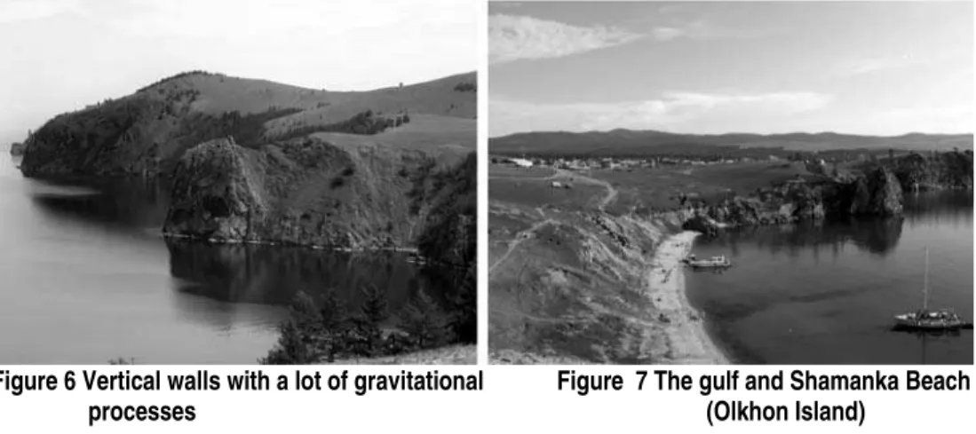
Figure 6 Vertical walls with a lot of gravitational Figure 7 The gulf and Shamanka Beach processes (Olkhon Island)
Low altitude landscapes include steppes with herbal associations (fig. 8), in some cases over this steppes grows pine tree forests (Pinus silvestris), but also dunes (fig. 9) and territories with strong human impacts (fig. 10).
Figure 8 Low land steppes Figure 9 Sands and dunes landscape (Olkhon Island)
References
Gâştescu,P., (1969), Lacurile pe glob, Edit.Ştiinţifică,Bucureşti
Gâştescu. P., (2008), Lacurile Terrei, CD PRESS Publishing House, Bucharest; Gurulev. S.A., (2000), The Faces of Baikal Names • The history and the origin of the
name ”Baikal”, http://www.bww.irk.ru;
Popa. I., (2007), Olkhon, insula şamanilor, TERRA MAGAZIN review, nr. 10 (128) / October 2007;
Popa. I., (2007), Lacul Baikal, un ochi adânc, albastru, TERRA MAGAZIN review, nr. 11 (129) / November 2007;
Rossolimo, L.,L., (1971), Baikal, Vostocino-Sibirskoe Knijnoe Izdatelistvo;
Touchart, L., (1996), Le Baïkal, Annales de Géographie, vol. 105, no 589, p. 235-256.