IDE-OTALEX. The first crossborder SDI between
Portugal and Spain
Teresa BATISTA1, Cármen CABALLERO2, Fernando CEBALLOS2 and Cristina CARRIÇO3
1
CIMAC, ICAAM-University of Évora/Portugal [email protected]; 2
Junta de Extremadura/Espanha [email protected];
3
CIMAC/Portugal [email protected]
Abstract
IDE-OTALEX is the first crossborder spatial data infrastructure between contiguous Portuguese (Alentejo and Centro) and Spanish (Extremadura) regions.
IDE-OTALEX was implemented to share official geographic information, from Alentejo and Extremadura, and now Centro region, with everyone. This is the most effective way to have a distributed and flexible system to be used as a territorial observatory for sustainable development and environment protection in these rural and low populated regions. It also contributes to territorial cohesion, one of the tree main pillars of European Cohesion Policy. It’s characterized for being a distributed, decentralized, modular and collaborative system, based on standards (OGC, W3C, ISO) and open source technology, developed to guarantee interoperability between the different GIS provided by each project partner. The geoportal is multilingual (Portuguese, Spanish and English) and integrates a Map viewer, Metadata Catalogue and Gazetteer. It consists in central and local nodes which communicate through WMS (Web Map Services), CSW (Catalog Service Web) and WFS (Web Feature Services). It is now implementing SOS (sensor observation services) and WPS (web map processing).
The geographic information on it available results of an extensive work of data harmonisation adapted to INSPIRE Directive (D 2007/2/EC, of the European Parliament and Council, of March 14, 2007). It integrates basic cartography, socio-economic and environmental indicators.
1
Introduction
OTALEX C is the Territorial and Environmental Observatory of the crossborder region composed by Alentejo and Centro regions of Portugal and Extremadura region of Spain, build up on the close cooperation between several Portuguese and Spanish entities who collaborates in the fields of landscape management and geographic information systems since 1997. Along these 16 years, several projects where developed with the co-finance of
the Crossborder Cooperation Programmes for Spain-Portugal of the European Regional Development Fund (ERDF).
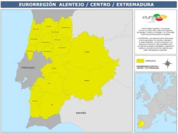
It aims to monitor and analyse territorial and environmental changes and pressures on both sides of the Spanish-Portuguese border. The project area is composed by three administrative units (NUTSII): Alentejo and Centro of Portugal, and Extremadura in Spain, involving about 92.200 km2 and having the same geographic area of the European region EUROACE – Alentejo-Centro-Extremadura, created in 21 September 2009, as an organizational structure that aims to reinforce cooperation between these three regions who share’s a common border and problems.
These are sparsely populated regions (less than 37 inhabitants per km2) with a generalised high aging index and low natural growth, which has been partially contradicted by immigration. The main economic activities are agriculture and services. They are also quite rich in natural, built and landscape heritage, including several nature conservation sites and protected areas (Natura2000, SPAs and National Parks). However these regions are also threatened by different kinds of pressures: urban and industrial expansion, abandonment of traditional land systems, impacts of Common Agriculture Policy (CAP), soils contamination, erosion and loss of fertility, clime changes, and others, which are causing increasing impacts on the environment, biodiversity and local populations.
Sensitive to these problems and to the difficulty of having quality geographic information (GI) available of all this territory, project partners decided to create in 2007 the first non-pilot crossborder Spatial Data Infrastructure – SDI-OTALEX (www.ideotalex.eu), which integrates national, regional and local administrations levels, as the first GI sharing platform of Alentejo, Centre and Extremadura. Despite different data sources (portuguese and spanish and different entities), SDI is feed by harmonized information of the whole area (Álvarez et al 2010, Batista 2009).
OTALEX is the first cross border non-pilot and multilingual SDI project in Europe. Thought all this time, it was consolidated an inter institutional and multidisciplinary work team, that works together until today.
2
IDE-OTALEX C
Spatial Data Infraestrutures are, in general, for their characteristics, the best tecnological tool to publish sustainability data in the web. They can synthesize, calculate and analyse spatial data through interoperable web based services. SDIs are essential to manage natural resources, economic development and environment protection in a way to follow the changes of the territory.
IDE-OTALEX C was implemented to share oficial geographic information, from Alentejo and Extremadura, and now Centro region, with everyone. This is the most effective way to have a distributed and flexible system to be used as a territorial observatory for sustainable development and environment protection in this rural and low populated regions. It also contributes to territorial cohesion, one of the tree main pillars of European Cohesion Policy. It’s characterized for beeing a distributed, decentralized, modular and collaborative system, based on standards (OGC, W3C, ISO) and opensource technology, developed to guarantee interoperability between the different GIS provided by each project partner. The geoportal is multilingual (Portuguese, Spanish and English) and integrates a Map viewer, Metadata Catalogue and Gazetteer. It consists in central and local nodes which communicate through WMS (Web Map Services), CSW (Catalog Service Web) and WFS (Web Feature Services).
The geografic information on it available results of an extensive work of data harmonisation adapted to INSPIRE Directive (D 2007/2/EC, of the European Parliament and Council, of March 14, 2007). It integrates basic cartography, socio-economic and environmental indicators.
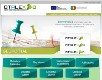
Fig. 2: Home page of the website IDE-OTALEX C– www.ideotalex.eu
OTALEX developed also an Indicator System – SI-OTALEX, to identify and measure, monitor and evaluate human pressures and its dynamics in the region. The established set of indicators has a common and standard structure designed by a multidisciplinary team with
experts from both countries. It main objective is to evaluate the transformations of the territory and help to solve common problems of the territory and their populations.
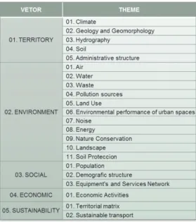
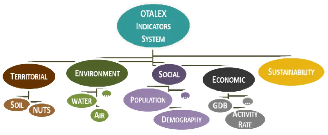
Following the guidelines of the Sustainable Development Strategy of the European Union (EU-SDS), the national Development Strategies for Portugal and Spain, SI-OTALEX was framed by the conceptual model PSR (Pressure-State-Response), adopted from OECD (1993). Although we know that choises always involves disregarding something (IISD, 1999), since there is no universal set established, and there is such a high and diverse number of indicators, the core indicators for SI-OTALEX was built with those that best fit the project objectives, ad more relevace and representativeness in the area, and also easily available and measurable. Furthermore they should be simple, easy to read and update. To each of the structure elements was assigned a code number in the hierarchical system comprising by three levels. Vectors, themes and indicators. The fist one, the most wide, integrates five vectors: territory, environment, social, economic and sustainability.
These vectors include now twenty two themes such as climate, hydrography, soils, air, water, waste, landscape, land use, population, economic activities, and others (table 1). The thirth level is composed by the indicators themselves. Examples of these are water quality, waste management, green spaces in urban areas, landscape units, demographic structure, economic activities, and others (Carriço et al, 2011). Each indicator have an appropriate metadata file that characterize and explain the method for is calculation, sources of the original data, year, and other importante information that allows its aplication to other regions and periods.
The ultimate goal is to integrate this indicators in the IDE-OTALEX (www.ideotalex.eu), so each indicator was georreferenced and harmonized in terms of geometry, time and spatial scales, so they could be comparable and contiguos in OTALEX C territory.
It were made several developments in the indicators definitions. One of the most interesting was the new Rurality Index proposed by Mateos et al (2008) on OTALEX project and applied to OTALEX area. This indicator has its roots on the definitions proposed by the Spanish Ministry of Agriculture, Fishery and Food, the OCDE and Eurostat, but integrates also information from other indicators like population dynamics, aging index, main economic activity, health care and education centers, that in general gives a better information of the reality of the municipalities, and became an usefull tool for understand OTALEX area.
In addition it was made the first study on the effects of air pollution by the presence and distribution of wet acid deposition resulting from industrial emissions on OTALEX area (Cabezas et al, 2011) and the study and cartography 1:10000 for Central Alentejo (Guiomar et al 2009, Batista 2011).
In this thematic, was also developed a map based on lithology, slope and vegetation of OTALEX area that was used to collect soil samples. As final results, will be produced novel maps of several soils parameters such as pH, soil color, organic carbon, and others. Designed to be flexible and open SI-OTALEX is a GI platform, fulfill with updated information through each one of the local nodes, and available to everyone. It has not been easy to work with different definitions, criteria, and information sources, and obtain good results. But the team is committed in developing a reliable and consistent tool that will help to evaluate environmental performance to pressures and understand the territory and his dynamics.
Fig. 3: OTALEX Indicator System
3
Results
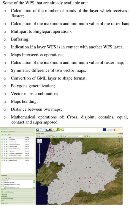
The main resuls are available in www.ideotalex.eu. Here we present several images of the different functionalities developed in IDE-OTALEX.
In the successive developments there have been added different tools that allow the users to take advantage of the information. These tools are:
•WPS (Web Processing Services, wich enable the execution of geoprocessing on the information. Some of the WPS that are already available are:
o Calculation of the number of bands of the layer which receives as input Raster;
o Calculation of the maximum and minimum value of the raster band; o Multipart to Singlepart operations;
o Buffering;
o Indication if a layer WFS is in contact with another WFS layer; o Maps Intersection operations;
o Calculation of the maximum and minimum value of raster map; o Symmetric difference of two vector maps;
o Convertion of GML layer to shape format; o Polygons generalization;
o Vector maps combination; o Maps bonding;
o Distance between two maps;
o Mathematical operations of: Cross, disjoint, contains, equal, within, contact and superimposed.
• Environmental Monitoring (SOS), responsible for collecting the measurements made by each of the sensors that comprise a network of environmental monitoring, and also for processing and publishing the resulting data.
• Environmental Evaluation System. This tool helps to make decisions in spatial planning at different level, allowing concatenation of geoprocessing (WPS). • Local Nodes Remote Administration. Remotely enables management of
information from different local nodes.
At the same time several books and articles were published (AAVV 2011, Batista et al 2011, Batista & Rodriguez 2006, 2006a, Guiomar et al 2009, Batista 2011, Ceballos & Velasco 2005, Ceballos et al 2007, DGUOT 2008, Mateos et al 2008) referring to the results of this cooperation.
With an oriented architecture to services, IDE-OTALEX is the sharing platform for spatial data, information and resources, for Alentejo, Centro and Extremadura regions, in a very flexible and dynamic way through the web.
5
Conclusion and Outlook
For its particular characteristics, OTALEX has become one distinctive project. It has established a permanent crossborder cooperation channel between the different administration levels. It ranges local (intermunicipal communities and diputaciones, that represents municipalities), regional (Junta da Extremadura and Comissão de Coordenação Desenvolvimento Regional do Alentejo – CCDRA), national (National Geographic Institutes – IGN and IGP), high education institutes (University of Évora, University of Extremadura and Polytechnic Institute of Castelo Branco), and public enterprises (EDIA) of two different countries, Spain and Portugal. This fifteen years of cooperation keep on going and it is getting stronger and useful among users.
OTALEX is a Best Practice case of the INTERREG III-A Program of Crossborder Cooperation Spain-Portugal 2000-2006.
In 2009, it was invited to be candidate to the SDI Best Practice Award in the eSDI-Net+ project context (eSDI-Net+ – www.esdinetplus.eu) and received a honour mention. In 2011 received a honour mention of the Association of European Border Regions (AEBR), in the
context of the AEBR Award of 2011
(http://www.aebr.eu/en/news/news_detail.php?news_id=41).
OTALEX is a member of the Spatial Data Infrastructure of Spain since March 29th, 2011, and is one of the three environmental geoportals. It is also a member of the Directive Council of the Spatial Data Infrstructure of Spain and of OSE – Observatorio de Sostenibilidad de España.
As future outcomes, the partnership is committed in extending its main work to the new intervention area Centro of Portugal, consistently with the European strategies of crossborder cooperation, and EuroACE Strategy 2020.
It is also developing the interface of IDE-OTALEX, developing new tools, such as WPS (Web Processing Services), Sensor Observation Services (SOS), linked data studies, SDI OTALEC C to mobile devices (Android) and sustainability indicators.
References
AAVV (2011). Atlas Otalex II. Coord. Edição Dir. General de Urbanismo y Ordenación del Territorio. Junta de Extremadura. Mérida (Espanha). Dep. Legal BA - 000292-2011. ÁLVAREZ, R., CABALLERO, C., CEBALLOS-ZUÑIGA, F., SORIANO, M., BATISTA, T., MATEUS, J., VIVAS, P., LUNA, J., SERRA, L., CABEZAS, J. AND PINTO C. (2010). Otalex II - Una IDE Transfronteriza y Observatorio Ambiental. Mapping, Revista Internacional de Ciencias de la Tierra, 141:14-19.
BATISTA, T, CARRIÇO, C. CEBALLOS F. AND DELGADO P. (Coord.) (2011). OTALEX II - Resultado do Projecto/ Resutado del Proyecto. CIMAC y DGUOT Coord. Ed. VV. Dep. Legal BA - 000365-2011.
BATISTA, T. & RODRIGUEZ, F. (Dirs.) (2006). GEOALEX – Modelo de gestão ambiental e territorial para a área transfronteiriça Alentejo-Extremadura. Agencia Extremeña de la Vivienda, el Urbanismo y el Terrotório (Junta da Extremadura) e Associação de Municípios do Distrito de Évora (Edts.). Tecnigraf. Badajoz.
BATISTA, T. & RODRIGUEZ F. (Dirs.) (2006). GeoALEX – cartografia comum Alentejo-Extremadura. Agencia Extremeña de la Vivienda, el Urbanismo y el Território (Junta da Extremadura) e Associação de Municípios do Distrito de Évora (Edts.). Tecnigraf. Badajoz.
BATISTA, T. (2009). Spatial Data Infrastructures - key issue for territorial cooperation in Europe: IDE-OTALEX - Alentejo and Extremadura Territorial and Environmental Observatory, Parliament Magazine’s, Regional Review Open Days, 14: 135.
BATISTA, T. (2011). Carta de ocupação e uso do solo do Distrito de Évora e Município de Sousel – Legenda Corine Land Cover Nível 5. CIMAC (Edt.). Évora. Publicação acoplada ao livro com ISBN 989-95985.
CABEZAS, J., FERNÁNDEZ-POZO, L., RODRÍGUEZ, M. A., RÍOS, N., BATISTA, T., MENDES, P., VILA-VIÇOSA, C. AND C. PINTO-GOMES (2011). Traços Biofísicos en el Territorio OTALEX / Rasgos Biofísicos en el Territorio OTALEX. OTALEX II Resultado do Projecto/ OTALEX II Resultado del Proyecto. Ed. Junta de Extremadura (Edts.). pp. 97-109.
CARRIÇO, C., BATISTA, T. DURÁN, M. LOPES, H. GARRIDO, A. VAQUERO, V. AND E. FLORES (2011). “O sistema de Indicadores do Projecto OTALEX II/ El sistema de Indicadores del Proyecto OTALEX II”, in Batista, T., Carriço, C. Ceballos F. and Delgado, P. (Coord.) OTALEX II - Resultado do Projecto – Resultado del Proyeto. (Coord. Ed.) CIMAC and Dir. Gen. Urb. y Orden. Territ. pp.53-65, s.l.
CEBALLOS, F. AND VELASCO C. (2005). Estudio sobre las parcelaciones, urbanizaciones y edificaciones exteriores a los perímetros urbanos y urbanizables, en
Extremadura y Évora. Agencia Extremenha de la Vivienda, del Urbanismo y el Territorio (Junta da Extremadura) y Associação de Municípios do Distrito de Évora (Edts.) DL:BA-855/2005. 123 pp.
CEBALLOS, F., VELASCO, C., MATEOS, J. (2007). Una Estrategia Territorial para Alqueva. Agencia Extremenha de la Vivienda, del Urbanismo y el Territorio (Junta da Extremadura) (Ed.). 151 pp.
D.G.U.O.T. - JUNTA DA EXTREMADURA (Coord. Ed.) (2008). Otalex – Observatorio Territorial Alentejo Extemadura. Resultado Final Proyecto/Resultado Final Projecto. DL BA-723-2008. 203 pp.
EEA (1999). Environmental indicators: Typology and overview. European Environmental Agency. Technical Report n.º 25. Denmark.
EUROACE2020 (2010). Uma estratégia para a Euroregião Alentejo-Centro-Extremadura de Outubro de 2010 (http://www.euro-ace.eu/pt-pt).
GUIOMAR N., BATISTA T., FERNANDES J. P. AND C. SOUTO CRUZ (2009). Corine Land Cover Nível 5. Contribuição para a Carta de Uso do Solo em Portugal Continental. AMDE (Edts). Évora. 226 pp. ISBN 989-95985.
IGN. (2011). Carta Extremadura Alentejo (escala 1:600000).
IISD (1999). Indicators for Sustainable Development: Theory, Methods, Applications. A Report to the Balaton Group. International Institute for Sustainable Development, Hartmut Bossel (Ed.).
MATEOS, J., VAQUERO, V., LOPES, H., FLORES, E. AND A. ROLDÃO OLIVEIRA (2008). Modelo de datos socioeconomico y físico-ambiental de OTALEX: metodologia, análisis y resultados à escala regional in D.G.U.O.T. - Junta da Extremadura (Coord. Ed.). 2008. Otalex – Observatorio Territorial Alentejo Extemadura. Resultado Final Proyecto/Resultado Final Projecto. DL BA-723-2008. 23-64 pp.
OECD (1993). OECD core set of indicators for environmental performance reviews. OECD Environment Monographs No. 83. OECD.