HYDROLOGICAL MODELING IN TEMPORARY STREAMS: A CASE STUDY IN PARDIELA BASIN, SOUTHERN PORTUGAL
Ana Pedro*, Manuela Morais*, Joana Rosado*, Lena Silva*, António Serafim*, Ramiro Neves**, David Brito**, Miguel Potes***, Rui Salgado***, Ana Lillebø****, António Chambel***
*Water Laboratory, University of Évora, Rua da Barba Rala nº1, PITE, 7005-345 Évora, Portugal
**IMAR – Institute of Marine Research, Department of Zoology, University of Coimbra, 3004-517 Coimbra, Portugal
*** Center of Geophysics, University of Évora, Rua Romão Ramalho nº59, 7000 Évora
****CESAM – Centre for Environment and Marine Studies, University of Aveiro, Campus Universitário de Santiago, 3810-193 Aveiro, Portugal
Abstract
The project “Conservation and rehabilitation strategies for temporary Mediterranean river corridors: a case study on Pardiela basin, southern Portugal (Guadiana basin)", is being carried out, with the collaboration of researchers from diverse scientific areas, in order to increase the knowledge on temporary streams. The project includes different approaches at reach and basin scales, regarding the study of temporal interactions among different ecological components such as climate, morphology of stream corridor and hydrology. The obtained results were integrated in basin models: Mohid Land, an integrant part of the software Mohid River Network and in SWAT model. The outputs from Mohid Land model defined that there is 10% average of probability of total annual runoff occurrence in headwater reaches. This means that, in headwaters reaches, which represent the major area of the river basin, the percentage of time without runoff is close to 90%, exposing the ephemerality of temporary headwater reaches, the most fragile areas. The main issue related to temporary rivers is regarding water scarcity since rainfall is concentrated in small temporal events which makes water availability management a complex issue. The sustainable development at local and regional levels requires the improvement of conservation and rehabilitation strategies for this ecosystem.
Keywords
Conservation strategies, Mediterranean, Mohid Land, Rehabilitation, Temporary streams
INTRODUCTION
Temporary streams are defined as those that are normally dry, at least during an extended part of the year, the summer in Mediterranean regions. They occur in arid and semi-arid regions worldwide, but also in temperate areas with a high presence in the Mediterranean (Meyer et al., 2003). They are physically, chemically and biologically shaped by sequential, seasonal events of flooding and drying over an annual cycle (Gasith and Resh, 1999). The Mediterranean climatic conditions are characterised by extended periods of dry spells and wet periods with a regime of irregular precipitation, with flash flood, associated with low probabilities of occurrence (European Commission, 1998). Economic development in regions with a lack of available water (e.g. arid, semi-arid and Mediterranean) is closely linked to efficient use of this limited resource. Management and conservation of these resources requires optimization of the interrelationships between supply quantity and resource quality (Hambright et al., 2000). The expansion of water resource development (e.g. dams, hydropower plants, irrigation projects) in the prospect of creating a balance between supply and demand is a threat to the natural flow regime and ecological integrity of rivers and streams in Portugal. Besides the management of the decreasing water resources, as a result of the climatic changes within the Mediterranean region, is not easy, as it will coincide with an increase in population, high agricultural demands and high development pressures (Iglesias et al., 2006). Population increase in Mediterranean-climate regions, predominantly in fertile regions, results in an intensification of the competition for water among different users; consequently, water
abstraction, flow regulation, increased salinity, and pollution severely limits the ability of streams to survive as sustainable, self-regulated systems. The Water Framework Directive (European Commission, 2000) aims to provide the mechanisms to prevent further deterioration and to protect and enhance the status of aquatic ecosystems. It has an environmental goal that by the year 2015, all surface and groundwater in Europe will achieve a classification defined as good ecological status. The development of accurate scenarios will be an issue of utmost importance. Portugal is in the process of developing sectoral and overall water demand scenarios at the river basin level. However, water availability cannot be considered independently of water quality, which is related to the aquatic ecosystems. In order to manage this resource it is necessary to develop rehabilitation and conservation strategies adapted to temporary Mediterranean streams. The first step when generating strategies is to develop hydrologic models specific to temporary river basins in order to improve the simulation of present conditions and better predict future scenarios in terms of water availability and quality. The objectives of this study are: i) to implement and validate a system of models to analyse the main water fluxes in the Pardiela basin; ii) to determine the role of the riparian vegetation in the fluxes between stream and basin; iii) to develop management strategies that take in to account the model previously developed.
METHODS Study area
This study was conducted in Pardiela’s basin, a Mediterranean river basin in the south of Portugal. Pardiela is a fourth-order temporary stream, located in southeast Portugal (38° 26’ N, 07° 41’W) (basin area 514 Km2; Figure 1). Its basin ranges from 505 m at headwaters to 169 m, at its mouth with Degebe River (Gallart et al., 2008). The average air temperature ranges from 9ºC in winter to 23ºC in summer, with average annual precipitation of 600 mm (Lillebo et al., 2007). Pardiela has low discharges in the summer and high discharges in the autumn/winter. During summer, the riverbed dries out, especially in headwater and mid basin reaches. Downstream reaches contain water all year due to the presence of one dam (in a 3rd order tributary) and one weir, at the confluence with Degebe River. In the Pardiela basin the vegetation is dominated by oak, olive groves, vineyards and pasture land. Riparian vegetation is fragmented and mainly composed by ash (Fraxinus angustifolia), willows (Salix atrocinerea and Salix salviifolia), poplars (Populus nigra) and african tamarisk (Tamarix africana). In order to determine the dynamic of the water fluxes in Pardiela basin (evapotranspiration, superficial flow, and groundwater flow) and the percentage of time with superficial flow, two models Mohid Land and Soil and Water Assessment Tool (SWAT) were applied. The studied basin did not consider the affluent that contains Figure 1. Location of Pardiela basin in Portugal, not considering the
Vigia reservoir since it would change the natural water flow and would imply the use of a more detailed modelling (Figure 1). A more detailed analysis was necessary to determine the role of the riparian vegetation in the fluxes between basin and river. The chosen reach was upstream from the water level station, were existed several summer pools which allow for the development of a wider riparian vegetation (Figure 1).
Models Description
Mohid Land is the hydrology module in the 3D Mohid Water Modelling System. The Mohid Land section is a watershed mathematical model or hydrological transport model, designed to simulate the flow of water in a drainage basin and aquifer. It comprises four compartments (atmosphere, porous medium, overland runoff and drainage system) and the water moves between compartments taking into account mass balances and quantity of movement. The St. Venant equation is used to determine the drainage system and the overland runoff (Trancoso et al., 2009). The infiltration and soil redistribution is calculated by Richards equation. The Mohid Land was used to study the basin for the period between 2007 and 2009. The riparian vegetation module was developed using the same concepts of the vegetation grow model from SWAT (Neitsch et al., 2005). The roots depth and biomass, plant height, Leaf Area Index and the nutrient demand were calculated taking into account the stage of the plant, described by Neitsch et al. (2005). The evapotranspiration was calculated using the standardized Penman-Monteith equation from FAO. The simulation of the riparian reach in the Mohid Land model consisted of a series of tests of the floods and pos-flood conditions during a month period. For the simulation of the flood conditions a discharge of 1m3/s was defined, taking in to account the data from February of 2008, a month characterised by high discharges. For the situation of pos-flood the discharged was defined as 0.01m3/s, average discharge from June 2008, after the raining events of that year. The riparian vegetation was distributed along the river in a band with 150m width and the roots depth was fixed at 2m. Also to determine the river influence in the presence/absence of riparian vegetation, a summer situation was simulated, with duration of four months, considering the dry soil and an increment of hydric stress.
Soil and Water Assessment Tool (SWAT) is a model developed by the United States Department of Agriculture which simulates the discharge and the nutrients cycles via data from the weather, soil, land use and agriculture. The SWAT model divides the basin in hydrological unit (sub-basins) accordingly to topography, soil characteristics and land use. The hydrodynamic module determines the water balance through the interaction between atmosphere, soil, vegetation and aquifer. The water quality module solves the vegetation growth, the nutrient cycles and the transport of sediments and pesticides.
The input dataset for both models included data from: Soil Texture (European Soil Bureau; http://eusoils.jrc.ec.europa.eu); Corine Land Cover 2000 (http://dataservice.eea.europa.eu/); DTM (data from NASA, with a resolution of 90m, http://edcsns17.cr.usgs.gov/NewEarthExplorer/); climatic data from SNIRH stations (http://snirh.pt). On site measurements included data from 1) a Climatic Station, installed in the study reach, measuring in continuous: temperature (°C), precipitation (mm), wind speed (m/s) and direction (º), global solar radiation (W/m2) and relative humidity (%); 2) a Yellowspring automatic multi-parameter probe, in the riverbed, measuring water level (m), every 30 minutes, and 3) discharge measurements in the study reach, preformed during and after the flood events and in each month, during the two hydrological years (from October 2007 to October 2009). The SWAT model was used to study the basin, with 200 hydrological units for the period between 1991 and 2009, using data from the climatic station and SNIRH.
RESULTS AND DISCUSSION
The validation of Mohid Land and SWAT models for the discharge revealed a good adjustment to data. The best results corresponded to the hydrological year of 2008-2009 with an r2= 0.99 for both models and efficiency (Nash-Sutcliffe coefficient) of 0.54 for the Mohid Land and of 0.95 for the SWAT. A comparison between the estimated discharge from Mohid Land, SWAT and in site discharge measurements showed that they were able to recreate the occurrence of peaks at the right time and size along with the general base-flow (Figure 2).
Figure 2. Models output of daily discharge between October 2007 and September 2009. Light grey line – Estimated discharge from Mohid Land model; Doted grey line – Estimated discharge from SWAT model; Black line – In site discharge measurements.
The pattern of annual discharge presents an expansion period, mainly from October to April, and a contraction period, from late May to September. The stream starts to flow with the first flood event and maintains the base flow usually until late spring, when the absence of precipitation together with the rising temperatures, gradually leads to an interruption in river flow, and consequent contraction into large pools (Rosado et al., in press). The daily discharge presented in Figure 2 is in accord with the pattern characteristic of temporary streams. The runoff regime in temporary streams is essentially torrential with short periods of flooding and part of the year without flow. Measured discharge values point to five months each year dry, which corresponds to about 40% of the time, with merely 20% of the time presenting a discharge higher than 1m3/s. The models presented similar dynamics with 30-35% of the time without discharge and 10-20% of the time with discharges above 1m3/s. The extent of the dry period raises important concern in regard to the management of this resource. Specially because during the dry season is frequent to observe uncontrolled water abstraction together with the free access of livestock to the riverbed, which provides an additional problem of human health and disturbance of in-stream aquatic habitats (Rosado et al., in press). It is necessary to look at the climate, more precisely at the precipitation, when trying to understand why during five months each year there is no superficial flow. Because even with an average annual rainfall of 550 mm (period between 1991 and 2009), only a small part of this reaches the stream. Accordingly to SWAT model results only about 13% of the precipitation reaches the stream. Pointing out that the compartment which retains more water is evapotranspiration, that on average holds about 80-90% of the rainfall, while the subterraneous runoff only gains about 10%, but this percentage might be bigger in humid years in response to the soil saturation.
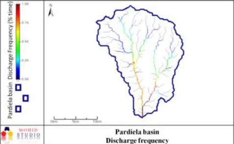
The Mohid Land model using the same concept as the frequency of discharge for each cell originates the map in Figure 3. The headwater reaches present flow only during/after events of heavy rainfall, which corresponds to about 10% of the time. In the mid basin reaches, that include
the water level station, the river starts to flow with the first flood event and maintains the base flow until late spring, which corresponds to more than half of the time, about 60% of the time. Compared to mid basin reaches, downstream reaches, present a similar flow regime evolution but with higher levels and less days without flow, which correspond to about 80-90% of the time with superficial flow.
Figure 3. Map with the frequency of discharge for the hydrological years of 2007-2008 and 2008-2009. Blue line – Pardiela basin; Orange square – Water level station.
The simulation of flood conditions to determine the role of the riparian vegetation, determined that with lower levels of the aquifer the flux of water to the soil is bigger. However the effect of the riparian vegetation is more effective when the aquifer water level is closer to the range of the roots, since it increases the water available for transpiration. When the aquifer level is higher than the river, the water flux is inverted and the aquifer loses water to the river. Another circumstance that changes the water flux is soil saturation, which makes it very hard for the vegetation to extract water. The presence of riparian vegetation during flood events increases the input of water to the soil by 5% in the worst scenario with lower aquifer levels and by 70% in the best when the aquifer level is close to the roots. In the pos-flood simulation the riparian vegetation decreases the water flux from the soil to the river by 20% in the worst scenario, with the aquifer level too high, and by 40% when the aquifer level is closer to the roots. These results demonstrate that riparian vegetation has a key role in downsizing the effects of floods in the flux between basin and river. The simulation of the summer situation demonstrated that only plants very well adapted to the natural conditions would survive away from the river, since only close to the main channel the values of hydric stress are lower. The restoration of the riparian vegetation corridors alongside the river will serve as a buffer, especially in the flood and pos-flood period.
Numerous studies in Mediterranean climate areas, demonstrate that the decrease in water availability during an annual cycle makes ecosystem sustainability particularly delicate (e.g. Baron et al., 2002). The existing trend pattern of increasing temperature and the beginning tendency of decreasing precipitation, detected in Pardiela basin (Rosado et al., in press) is another worrisome problem since it will further decrease the water availability. This requires the use of adequate models to predict the water availability bearing in mind the future scenarios of climatic change and the improvement of management and conservation strategies for Mediterranean temporary streams. They are precious ecosystems that were recognized as one of the first 25 Global Biodiversity Hotspots (Myers et al., 2000). As a result, countries must assure that their biological, functional and conservation value is being protected. Considering the EU Water Framework Directive (European
Commission, 2000) objectives for 2015, it is important to define “pilot basins” where specific conservation and rehabilitation strategies can be tested. Management and conservation strategies must take into account the equilibrium between human supplies and ecosystem health. Particular attention must be directed into small temporary basins, where land use and the access of livestock to the river channel have consequences in riverbed and margins degradation. The role of temporary rivers is frequently not recognized, especially during the summer, when the riverbed gets dry, and becomes another area exploited by local populations. It is necessary to develop educational programmes focused on the ecological value of temporary Mediterranean rivers. The knowledge of physical and biological problems from other temporary river basin (e.g. Gómez et al., 1995, Gómez et al., 2005), allows for the proposition of a few general management strategies. The conservation and rehabilitation strategies must consider critical the headwater reaches, which possesses the largest problem in water availability. Management strategies should be directed to stakeholders and to landowners (Table 1). The proposals must rely not only in accurate political strategies but also in educating the local population, which are one of the most important elements in river preservation. Table 1. Management and conservation strategies for temporary Mediterranean rivers (adapted from Rosado et al., in press).
Political and technical proposals
Management Plans should include temporary streams basins (landscape and riparian areas) and adapt assessment and management strategies to their characteristics.
Hydrologic models have to be specific to temporary river basins in order to improve simulated present conditions and better predict future scenarios in terms of water availability and quality.
Human activities in temporary river corridors and basins should be regulated and restricted were necessary. It must be developed a network to identify critical points.
Stakeholders and landowners should be made aware of the necessity of applying strategies to preserve riparian vegetation and lateral margins.
“Pilot river basins” must be selected, according to their biological and/or ecological significance or quality status, for the application of management and conservation measures. Social and educational proposals
Stakeholders and locals should be educated regarding the importance of temporary rivers, the protection of their biodiversity to maintain the water quality. They also must be offered technical support and guidance concerning management problems.
When necessary, apply regulation via economic incentives such as funding or decrease in taxes rate.
CONCLUSIONS
Recent studies sustain that there is a decrease of rainfall in the Mediterranean (Bladé and Díez, 2010) and an increase in temperature (Rosado et al., in press), which will further augment the problems in the Pardiela river basin, reducing water availability for surface and aquifer systems. Several other authors also predict that until 2070s there will be a decline in annual runoff by up to 36% in the south (Alcamo et al., 2007) and an escalating drought risk in western and southern Europe (Lehner et al., 2006). The main issues concerning headwater reaches in Pardiela is that they only have natural flow when there are consecutive days with high precipitation, which leads to an
intensive land-use ignoring the presence of a stream. Despite the interruption in river flow, under natural flow conditions, the mid and downstream reaches are subjected to anthropogenic disturbances, especially the extraction of water for agriculture. This is important during the summer, when the water abstraction together with the free access of livestock to riverbed provides an additional problem of human health, disturbance of in-stream aquatic habitats and destruction of the river corridors. The destruction of the riparian vegetation increases the problems of water quality, since there is no buffer to retain many of the basin runoff. These uses are common in Mediterranean regions where human populations depend largely on streams and rivers to fulfil their water demands (Gasith & Resh, 1999). Given that it is most likely that the first impacts of climate change will be felt in water resources, it is extremely important to develop management and conservation strategies (see Table1), that ensure not only human supply, in terms of quantity and quality, but also preserves biodiversity.
REFERENCES
Alcamo J., Floerke M. and Maerker M. (2007) Future long-term changes in global water resources driven by socio-economic and climatic changes. Hydrological Sciences, 52, 247-275.
Baron J.S., Poff N.L., Angermeier P.L., Dahm C.N., Gleick P.H., Hairston N.G., Jackson R.B., Johnston C.A., Richter B.D. and Steinman A.D. (2002). Meeting ecological and societal needs for fresh water. Ecological Applications, 12, 1247-1260.
Bladé I. and Castro-Díez Y. (2010). Tendencias atmosféricas en la Península Ibérica durante el periodo instrumental en el contexto de la variabilidad natural. In: Clima en España: pasado, presente y futuro, Pérez FF, Boscolo R (eds), Rede temática Clivar Espanha, pp. 25-42.
European Comission (1998). Towards sustainable water resources management: a strategic approach. ECSC-EEC-EAEC, Brussels, Luxembourg, pp. 1-352.
European Commission (2000). Directive 200/60/EC of the European Parliament and the Council of 23rd October 2000 establishing a framework for community action in the field of water policy. Official Journal of the European Communities, L327, 1-72.
Gallart F., Amaxidis Y., Botti P., Canè G., Castillo V., Chapman P., Froebrich J., García-Pintado J., Latron J., Llorens P., Lo Porto A., Morais M., Neves R., Ninov P., Perrin J.L., Ribarova I., Skoulikidis N. and Tournoud M.J. (2008). Investigating hydrological regimes and processes in a set of catchments with temporary waters in Mediterranean Europe. Hydrological Sciences–Journal–des Sciences Hydrologiques 53(3).
Gasith A. and Resh V. (1999). Streams in Mediterranean climate regions: abiotic influences and biotic responses to predictable seasonal events. Annu. Rev. Ecol. Syst., 30, 51-81.
Gómez R., Hurtado I., Suárez M.L. and Vidal-Abarca M.R. (2005). Ramblas in south-east Spain: threatened and valuable ecosystems. Aquatic Conserv: Mar. Freshw. Ecosyst, 15, 387-402.
Gómez R., Vidal-Abarca M.R., Suárez M.L. and Fisher S.G. (1995). The spatial and temporal scale problem in arid zone wetlands management. In: Bases Ecológicas para la Restauración de Humedales de la Cuenca Mediterránea, Montes C, Molina F, Cobos J (eds). Junta de Andalucía: Spain, pp. 95-105.
Hambright K., Parparov A. and Berman T. (2000). Indices of water quality for sustainable management and conservation of an arid region lake, Lake Kinneret (Sea of Galilee), Israel. Aquatic Conserv: Mar. Freshw. Ecosyst., 10, 393-406.
Iglesias A., Garrote L., Flores F. and Moneo M. (2006). Challenges to manage the risk of water scarcity and climate change in the Mediterranean. Water Resour. Manage, 21, 775-788.
Lillebø A.I., Morais M., Guilherme P., Fonseca R., Serafim A. and Neves R. (2007). Nutrient dynamics in Mediterranean temporary streams: A case study in Pardiela catchment (Degebe River, Portugal). Limnologica, 37, 337-348.
Lehner B., Döll P., Alcamo J., Henrichs H. and Kaspar F. (2006). Estimating the impact of global change on flood and drought risks in Europe: a continental, integrated analysis. Climatic Change, 75, 273-299.
Meyer A., Meyer E. and Meyer C. (2003). Lotic communities of two small temporary karstic stream systems (East Westphalia, Germany) along a longitudinal gradient of hydrological intermittency. Limnologica, 33, 271-279.
Myers N., Mittermeier R.A., Mittermeirer C.G., Fonseca G.A.B. and Kent J. (2000). Biodiversity hotspots for conservation priorities. Nature, 403, 853-858.
Neitsch, S.L., Arnold J.G., Kiniry J.R. and Williams J.R., (2005). SWAT 2005 Theoretical Documentation.
Rosado J., Morais M., Serafim A., Pedro A., Silva H., Potes M., Brito D., Salgado R., Neves R., Lillebø A., Chambel A., Pires V., Gomes C.P. and Pinto P. (in press) Key long term patterns for the management and conservation of temporary Mediterranean streams: a case study of the Pardiela river, southern Portugal (Guadiana catchment). In: River Conservation Management, Boon P.J. and Raven P.J. (eds). Willie Blackwell.
Trancoso, A.R., Braunschweig, F., Chambel Leitão, P., Obermann, M. and Neves, R.(2009). An advanced modeling tool for simulating complex river systems, Science of the Total Environment 407, 3004-3016.