FACULDADE DE CIÊNCIAS
DEPARTAMENTO DE GEOLOGIA
Plume-lithosphere interaction at Santiago Island
(Cape Verde): Implications for ocean island
magma genesis models
Sofia Maria Marques Martins
DOUTORAMENTO EM GEOLOGIA
(GEOQUÍMICA)
FACULDADE DE CIÊNCIAS
DEPARTAMENTO DE GEOLOGIA
Plume-lithosphere interaction at Santiago Island
(Cape Verde): Implications for ocean island
magma genesis models
Sofia Maria Marques Martins
Tese orientada pelos Profs. Doutores João Mata e José Munhá,
especialmente elaborada para a obtenção do grau de doutor em
Geologia (especialidade em Geoquímica)
2014
Plume-lithosphere interaction at Santiago Island
(Cape Verde): Implications for ocean island
magma genesis models
Sofia Maria Marques Martins
Doutoramento em Geologia
(Geoquímica)
In loving memory of my mother,
Maria Manuela Martins
i Santiago Island is the largest one in the Cape Verde archipelago with a total area of 991 km2. It belongs to the southern group with Maio, Fogo and Brava Islands. Apart from the
substrate (Complexo Antigo) Santiago's volcanostratigraphy is largely composed of subareal and submarine alkaline lavas outcrops, which cover a time span of circa 5 Ma.
Santiago alkaline lavas are testimony of a complex magmatic history, where chemical and lithological heterogeneous mantle sources and the interaction of advecting magmas with thick metasomatized oceanic lithosphere is preponderant in the observed isotopic and trace element signatures.
The distinctive major and trace element characteristics of Santiago lavas stand as a strong indicator of a carbonated mantle source with contributions from peridotitic and silica deficient garnet pyroxenite domains. The correlation of these elemental evidences with radiogenic isotopic data attests the presence of these domains within the plume, as well as their ancient signature.
Young (< 3.3 Ma) primitive Santiago lavas show evidence for the equilibration with modal and cryptically metasomatized oceanic lithospheric mantle. The metasomatism is responsible for the inferred hydrous mineral assemblage (amphibole and phlogopite) as well as specific geochemical tracers. Interestingly this signature is not ubiquitous in Santiago lavas mantle source, since the older formations do not show strong evidences for interaction with metasomatized domains of the lithosphere.
The carbonatitic nature of the metasomatic agent is attested from indirect geochemical signatures in alkaline lavas and direct evidence portrayed by lherzolitic xenoliths. It is important to acknowledge that the metasomatic agent composition is elemental and isotopically distinct from outcropping carbonatites.
In accordance with the overall isotopic characteristics of the Southern Cape Verde Islands, elemental and isotopic signatures of Santiago alkaline lavas suggest the involvement of HIMU and EM1-type mantle end-members, with the contribution a relatively undegassed and unradiogenic reservoir (Lower Mantle). The geochemical characteristics of Santiago allow us
ii
lithospheric mantle in Santiago’s magma genesis.
Tholeiitic outcropping lavas in the Santiago’s northern area are considered as formed in a mid oceanic ridge environment. The lavas are highly depleted in LREE and incompatible elements, even when compared with D-MORB values. This depletion seems to be ubiquitous in Central Atlantic MORB erupted between 160 to 118 Ma.
The eruption of highly depleted lavas at the initial stages of the Atlantic opening is here interpreted as the result of high degrees of partial melting induced by sub-lithospheric elevated temperatures brought on by continental thermal insulation.
Santiago gabbroic xenoliths show geochemical similarities with Santiago MORB affinity lavas attesting their cumulate formation from abyssal-type magmas. The enrichment observed in some is most certainly derived from the interaction of ascending alkaline magmas with the pre-existing N-MORB crust.
Keywords: Ocean island magmatism; Cape Verde; Plume-lithosphere interaction; Carbonatite metasomatism; Mantle lithologic heterogeneity; MORB.
iii A ilha de Santiago é a maior no arquipélago de Cabo Verde com uma área total de 991 km2. Pertence ao grupo Sul juntamente com as ilhas de Maio, Fogo e Brava. Não considerando o substrato (Complexo Antigo) a vulcanoestratigrafia de Santiago é constituída essencialmente por afloramentos de lavas alcalinas subaéreas e submarinas, que cobre um intervalo de tempo de cerca 5 Ma.
As lavas alcalinas de Santiago são testemunho de uma história magmática complexa, onde fontes mantélicas heterogéneas litológicamente e quimicamente e a ascensão de magmas através de uma litosfera oceânica espessa e metassomatizada, são preponderantes nas assinaturas isotópicas e em elementos traço observadas.
As características distintivas em elementos maiores e traço das lavas de Santiago são indicativas de uma fonte mantélica carbonatada com contribuições de domínios peridotíticos e piroxenitos granatíferos de baixa sílica. A correlação destas evidências elementares com dados isotópicos radiogénicos confirma a presença desses domínios na pluma, bem como a sua assinatura antiga.
As lavas primitivas recentes de Santiago (<3.3 Ma) mostram evidências para o equilíbrio com o manto litosférico metassomatizado cripticamente e modalmente. O metassomatismo é responsável pela associação mineralógica hidratada (anfíbola e flogopite) bem como traçadores geoquímicos específicos. Notavelmente, esta assinatura não é omnipresente na fonte mantélica das lavas de Santiago, uma vez que as formações mais antigas não mostram evidências para a interação com domínios metassomatizados da litosfera.
A natureza carbonatítica do agente metassomático é comprovada indiretamente, através de assinaturas geoquímicas nas lavas alcalinas e diretamente por evidências presentes em xenólitos peridotíticos. É importante salientar que a composição do agente metassomático é distinta elementar e isotopicamente dos carbonatitos aflorantes.
Em concordância com as características globais do grupo Sul das ilhas de Cabo Verde, as assinaturas elementares e isotópicas das lavas alcalinas de Santiago sugerem o envolvimento dos componentes mantélicos HIMU e EM1, com a contribuição de um reservatório relativamente desgaseificado (manto inferior). As características geoquímicas dos magmas de Santiago
iv
subcontinental.
As lavas toleíticas que afloram na área Norte de Santiago são consideradas como tendo sido geradas num ambiente de crista médio oceânica. As lavas são altamente empobrecidas em terras raras leves e elementos incompatíveis, mesmo quando comparadas com dados de D-MORB. Este empobrecimento parece ser ubíquo nos MORB do Centro Atlântico no período entre 160 e 118 Ma.
A formação de lavas altamente empobrecidas nas fases iniciais da abertura do Atlântico é aqui interpretada como o resultado de maiores graus de fusão, induzidos pelo aumento de temperatura em zonas sublitosféricas devido a isolamento térmico continental.
Os xenólitos gabroicos de Santiago mostram semelhanças geoquímicas com as lavas de afinidade com os MORB, comprovando a sua formação por acumulação de magmas do tipo abissal. O enriquecimento observado, em alguns, é certamente derivado da interação de magmas alcalinos em ascensão, com a crosta pré-existente.
Palavras-chave: Magmatismo de ilhas oceânicas; Cabo Verde; Interação pluma-litosfera; metassomatismo carbonatítico; heterogeneidade litológica mantélica; MORB
v
There are a number of people who deserve my heartfelt appreciation because, one way or other, helped me reach the end of this journey. I apologise in advance in case that somebody is missing from this list.
First of all I want to thank my supervisors, Professor Dr. João Mata and José Munhá, who proposed the continuation of my work in Santiago Island, initiated with my master's thesis. To Professor José Munhá I'm thankful for all the rewarding discussions and the availability demonstrated, as well as the patience in guiding me in the correct path.
To Professor João Mata I wish to thank not only for his role as my supervisor but also for being a dearest friend. I'm truly thankful not only for all the discussions, corrections, back and forth of the chapters, but also for is guidance towards my growth as an investigator and a teacher. He gave me confidence to believe in myself and my work by supporting me, criticizing my work (sometimes archly, but so necessary for a person to grow and learn), promoting international learning experiences and by the confidence demonstrated when working together. For me, Professor João Mata is a role model to whom I only aspire to be. The PhD process is a long one, more to some than others, and life goes on. I can honestly say that he was there for me during the losses, to support me, and during the happy times to rejoice with me. I'm truly grateful with all my heart for this journey together.
Special thanks for all the people that welcomed me at Université Libre de Bruxeles (ULB). A special word to Professor Nadine Mattielli who made me feel right at home. I learned a lot under her supervision not only at the laboratories but also working with the MC-ICP-MS Nu Plasma. I am also indebted to Claude Maerschalk for all that I learned at the laboratory, his meticulous methods will always be a guide to follow. I cherish our talks early in the morning at the lab. A further thank you to Sophie Verheyden, my office colleague, who was a great friend and helped me adapt to the university and the city. I'm also thankful to Jérôme Petit, Jeroen de Jung and Aurélien Taillez.
vi
I would like to acknowledge Professor Maria do Rosário Azevêdo for access to the Laboratório de Geologia Isotópica da Universidade de Aveiro (Portugal). Where, Sr and Nd isotopic analyses for MORB-type rocks were performed by Dr. Sara Ribeiro.
I would like to express my thanks to FCT (Fundação para a Ciência e Tecnologia) for funding a PhD scholarship (SFRH/BD/17453/2004) during four years and the financial support provided by two projects PLINT (POCTI/CTA/45802/2002) and CV-PLUME (POCTI/CTE-GIN/64330/2006), which were instrumental for the realization of this thesis.
A very special thank you to Professor Línia Martins my mentor as teacher and true friend. It is a pleasure and a privilege to work with her due to her inspiring and rich knowledge not only as a teacher but also as an educator. I love our daily talks about all things, big and small. I also treasure her caring words and advices.
I wish to thank Professor Isabel Costa for her friendship, constant concern and stimulating suggestions. A further thank you to other Professors for their motivational words and constant support: José Madeira, Luís Celestino da Silva, Raúl Jorge, Catarina Silva, Isabel Moitinho, Paulo Fonseca, Fátima Africano, Teresa Palácios and Filipe Rosas.
I am also indebted to the Departamento de Geologia staff for their precious help on bureaucratic issues and their sympathy: Sr. Alberto Verde, D. Cleta Melo, D. Nídia Pereira, Célia Lee, Ana Sousa, Marta Antunes, Dina Gouveia and Marisa Santos. Also, a special word of recognition to Sr. Chaveiro for all the countless hours on the microprobe, that due to his humours character and sympathy, passed swiftly. To Dr. Pedro Rodrigues a sincere thank you for the support in the microprobe, his patience and dedication to his work made the data acquisition a rewarding experience.
One of the most important recognition is to my family, specially my dad, José. If it wasn't for him, this thesis would not have been completed. In a more practical and direct way due to the constant and necessary financial support provided. The vicissitudes of such a prolonged PhD process, part of which with no scholarship associated, requires a financial sustainability not easily achievable in the nowadays economical situation. Also, I owe him the ability to start fresh every day, no matter how hard yesterday was. The importance of knowledge, the
vii
perseverance, strength and resilience necessary to achieve what a person aspires to, are all traits passed on by my parents who I love tenderly.
My sisters, Margarida and Sílvia, who I love so much, were always at my side, encouraging me and taking care of me. Their constant support enabled the conclusion of this journey. To my nephews Joseph, Collin and Miguel and niece Catarina a tender gratitude just for being present in my life…just the sight of them makes all things fall into place.
To my dearest friend and colleague Cyntia Morão I wish to thank her presence in my life. Her big heart, sensibility and friendship has no limits and in this long path she was one of my pillars, supporting me in every situation. As a colleague, our proximity regarding the studied subject, allowed the growth and maturation of many ideas portrayed in this thesis.
To my friend and colleague Inês Cruz a special thanks for her constant support, kind words and truthful companionship.
To a dear friend, Maria José Trindade, I wish to thank for always cheering me up and being there for me. A tender word of recognition to Carla Feiteira for her friendship, support, coaching lessons and for always demonstrating a hugely positive outlook on life.
A special thanks to Pedro Madureira for his constant encouragement, advices and caring words.
Other people that always helped and supported me through this process, being essential to put a smile in my face were: Isabel Martins, Zenaida Diogo, David Martins, João Carvalho, Filipa Marques, Paula Figueiredo, Ana Margarida Bento, Ana Jesus, Anabela Cruces, Rui Miranda, Telmo Santos, Bruno Ribeiro, Ricardo Ramalho and José Borrego.
I am also in debt to my managers at Bertrand, Vanda Verganista, Domingas Nogueira and Pedro Almeida who were always tolerant and helpful regarding my responsibilities in the university, as a PhD student and a teacher. Big thanks to my friends at the bookstore for their support: Ana Pessoa, Ana Filipa Neves, Bruno Oliveira, Bárbara Vasconcelos, Sofia Petisca, Rita Labareda, João Ferreira and Inês Lourenço.
Thanks also to all my students, for their interest and support and above all for helping me get through the more difficult days…teaching a class makes all the hardship worthwhile.
ix
Abstract ………... i
Resumo ………... iii
Acknowledgments ……… v
Table of contents ……….. ix
Glossary of acronyms and abbreviations ……… xvii
Chapter 1- Introduction 1.1 Interest………. 3
1.1.1. Why study intraplate magmatism? ……….. 3
1.1.2. Why study the Cape Verde archipelago? ………. 4
1.1.3. Aims of the study ………... 5
1.2. Structure of the thesis ………... 6
1.3. Analytical facilities ………... 7
Chapter 2 - Geologic and Geodynamic setting of the Cape Verde Archipelago 2.1. Introduction ………... 11
2.2. Geographic setting ………... 11
2.3. Geomorphologic characteristics ………... 12
2.4. Geotectonic setting ………... 18
2.5. Geodynamic context ………... 21
2.5.1. Geophysical particularities of the Cape Verde area ………... 24
2.5.1.1. Topography ………... 24
2.5.1.2. Heat flow anomaly ………... 25
2.5.1.3. Geoid and gravity anomalies ……….. 26
2.5.1.4. Crustal structure ………... 30
2.5.1.5. Lithosphere structure and its implications ……….. 32
2.5.2. Swell formation and support ………... 34
x
2.7. Deep mantle plume below Cape Verde Archipelago? ……… 39
2.8. Alternative models for the genesis of the Cape Verde Archipelago ………… 48
Chapter 3 - Santiago Island Geology 3.1. Introduction………... 53
3.1.1 Previous studies ………... 53
3.1.2. Morphological characteristics ……….. 54
3.2. Stratigraphy ………... 57
3.2.1. Complexo Antigo (CA) ………... 60
3.2.2. Flamengos Formation ………... 65
3.2.3. Orgãos Formation ………... 66
3.2.4. Pico da Antónia Formation ……… 67
3.2.4.1 Pico da Antónia Formation subunits ……….. 67
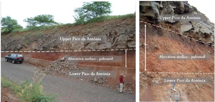
3.2.4.1.1 Upper and Lower Pico da Antónia distinction – field evidence … 70 3.2.5. Assomada Formation………... 77
3.2.6. Monte das Vacas Formation ……… 77
3.3. Geological evolution of Santiago Island: a synopsis ……….. 79
Chapter 4 - Geochemistry of alkaline lavas 4.1. Introduction ………... 85
4.2. Whole rock major and trace element chemistry ……… 86
4.2.1. Post-magmatic alteration ………... 86
4.2.2. Sample classification and characterization ………... 86
4.2.2.1 Primary and primitive magmas ………... 90
4.2.3. Major elements chemistry ………... 94
4.2.4. Trace element chemistry ………... 95
4.2.4.1. On the variability of Ce/Pb and Nb/U ratios ... 103
4.2.4.2. Nb/Ta vs. Zr/Hf – HFSE fractionation ... 104
4.3. Sr-Nd-Hf-Pb isotope chemistry ………... 113
4.3.2. Hf isotope data ………... 116
4.3.3. Pb isotope data ………... 118
4.3.3.1. Pb isotope signatures: outliers ………... 121
4.3.4. Isotopic heterogeneity ………... 125
4.4. Diversification of Santiago magmas ………... 126
4.4.1. Shallow-level assimilation ………... 126
4.4.2. Crystal fractionation processes ………... 129
4.4.3. Source heterogeneities ………... 136
4.4.3.1. Lithologic heterogeneity in the mantle ………... 137
4.4.3.1.1. Carbonated peridotite ………... 137
4.4.3.1.2. Carbonated silica-deficient eclogite/garnet pyroxenite ... 140
4.4.3.2. Mantle source mineralogy: a qualitative approach ... 148
4.4.3.3. Trace element inverse modelling constraints on residual mineralogy and degree of partial melting ... 151
4.4.3.3.1 - Enrichment factors ... 152
4.4.3.3.2 - Estimates of partial melting degree and modal composition of the source ... 155
4.4.4. Mantle metasomatism ... 160
4.4.4.1. Petrological and geochemical evidences from Santiago peridotitic/lherzolite xenoliths ... 161
4.4.4.2. The nature of the metasomatic agent: petrological and geochemical evidence from xenoliths ... 164
4.4.4.3. The nature of the metasomatic agent: geochemical evidences from Santiago lavas ... 166
4.4.4.3.1. Nature of the metasomatic agent ... 167
4.4.4.3.2. High radiogenic Pb isotopic signatures as evidence for metasomatism ... 171
4.4.4.4. On the origin of the carbonatitic metasomatic agent ... 175
4.5. Mantle components ... 179
4.5.1. Cape Verde archipelago isotopic dichotomy and diversity ... 184
xii
Santiago magmas ………...
4.5.2.2. Evidences for the occurrence of the HIMU component ... 188
4.5.2.3. Origin of the EM1 component ... 192
Sediments ... 193
Lower and upper continental crust ... 194
Lamproites and subcontinental lithospheric mantle (SCLM) ... 195
4.5.2.4. The contribution of the lower mantle ... 199
4.5.3. Contributors to the Santiago magmatism: Where does it come from? ... 200
4.5.4. Assessing the age of the oceanic crust recycling ... 203
4.5.5. Isotopic constraints to the relative proportions of the contributors to the Santiago magmas ... 210
Chapter 5 - Plume lithosphere interaction 5.1. Introduction ... 219
5.2. Specificities of the Cape Verde area ... 220
5.2.1. Lithosphere constraints ... 220
5.2.2. Plume constraints ... 222
5.2.3. ULVZ/LLSVP ... 223
5.3. Geochemical consequences of plume-lithosphere interaction ... 225
5.3.1. Lithosphere ... 225
Lid effect ... 225
Hydrous residual mineralogy ... 226
Further evidence for oceanic lithosphere metasomatism ... 227
5.3.2. The Role of SCLM ... 228
5.3.3. Carbonatites in oceanic environment ... 229
5.3.4. Plume components ... 232
5.4. Cape Verde magmatism: a time constrained model for the lithosphere contributions ... 232
187 4.5.2.1 On the putatitve role of FOZO as a contributer to
Chapter 6 – Gabbroic xenoliths and outcropping MORB: testimonies from the oceanic crust beneath Santiago Island
6.1. Introduction ... 237
6.2. Petrography and mineral chemistry ... 243
6.2.1. MORB Lavas ... 243
6.2.1.1. Plagioclase ... 243
6.2.1.2. Pyroxene ... 246
6.2.1.3. Opaque minerals ... 250
6.2.1.4. Secondary mineralogy ... 252
6.2.1.5. Fenitic carbonated pockets/vesicules and veins ... 254
6.2.2. Gabbroic xenoliths ... 258
6.2.2.1. Olivine ... 259
6.2.2.2. Plagioclase ... 260
6.2.2.3. Pyroxenes ... 261
6.3. Whole rock major and trace element chemistry ... 263
6.3.1. MORB Lavas ... 263
6.3.1.1. Classification and magmatic affinity ... 263
6.3.1.2. Major and trace elements ... 269
6.3.1.3. Rare earth elements ... 271
6.3.1.4. Other incompatible elements ... 273
6.3.1.5. Chemical alteration - effects on major and trace elements mobility 275 6.3.1.6. Fenitization - effects on major and trace elements ... 279
6.3.1.7. Sr-Nd isotope analysis of MORB lavas ... 279
6.3.1.8. MORB comparison around the Atlantic ... 281
6.3.1.9. High degree fractional melting event as cause for Santiago MORB singularity ... 285
6.3.2. Gabbroic xenoliths ... 287
xiv
Chapter 7 - Conclusions and future research
7.1. Introduction ... 295
7.1.1. Santiago Island Geology ... 295
7.1.2. Geochemistry of alkaline lavas ... 295
7.1.2.1 – Major and trace element geochemistry ... 295
7.1.2.2 – Sr-Nd-Hf-Pb isotope chemistry ... 298
7.1.2.3 – Diversification of Santiago magmas ... 299
7.1.2.4. – Mantle components ... 305
7.1.3. Plume-lithosphere interaction ... 309
7.1.4. Gabbroic xenoliths and outcropping MORB ... 311
7.1.4.1. Petrography and mineral chemistry ... 312
7.1.4.2. Whole rock major and trace element chemistry ... 315
7.2. Suggestions for future research ... 319
References ... 323 Appendixes
Appendix I – Sampling strategy
I.1. Alkaline lavas ... I.1 I.2. MORB-lavas ... I.1 I.3. Gabbroic xenoliths ... I.2 Appendix II - Methodology and analytical procedures
II.1. Rock crushing/powdering ... II.1 II.2. Whole rock major and trace element analyses ... II.1 II.3. Mineral major element chemistry ... II.6 II.4. Isotopic analyses ... II.7 II.4.1. Sr-Nd-Hf-Pb isotopic analysis at ULB (Brussels, Belgium) ... II.7 II.4.1.1. Leaching and chemical separation ... II.7
II.4.1.2. Mass spectrometry analyses ... II.8 II.4.1.3. Precision and accuracy ... II.9 II.4.2. Sr-Nd isotopic analyses at Laboratório de Geologia Isotópica
(Aveiro, Portugal) ...
II.10 II.4.2.1. Leaching and chemical separation ... II.10 II.4.2.2. Mass spectrometry analyses ... II.10 Appendix III – Analytical results
III.1. Whole rock ... III.1 III.1.1 Santiago Alkaline lavas ... III.2 III.1.1.1. Monte das Vacas Formation ... III.2 III.1.1.2. Assomada Formation ... III.3 III.1.1.3. Upper Pico da Antónia Formation ... III.5 III.1.1.4. Lower Pico da Antónia Formation ... III.8 III.1.1.5. Flamengos Formation ... III.10 III.1.2. Santiago MORB lavas ... III.12 III.1.3. Maio MORB lavas ... III.14 III.1.4. Santiago Gabbroic Xenoliths ... III.15 III.2. Isotopic data ... III.16 III.2.1. Santiago Alkaline lavas ... III.16 III.2.1.1 - Santiago Alkaline lavas - duplicate and replicate analyses... III.17 III.2.2. Santiago MORB lavas ... III.20 III.2.3. Maio MORB lavas ... III.20 III.3. EMPA data ... III.21 III.3.1. Santiago MORB lavas ... III.21 III.3.1.1. Pyroxene ... III.21 III.3.1.2. Plagioclase ... III.27 III.3.1.3. Amphibole ... III.58 III.3.1.4. Mica ... III.59 III.3.2. Santiago Gabbroic Xenoliths ... III.60
xvi
III.3.2.1. Pyroxene ... III.60 III.3.2.2. Plagioclase ... III.89 Appendix IV – CIPW norm
IV.1. Santiago Alkaline lavas ... IV.2 IV.2. Santiago MORB lavas ... IV.6 IV.3. Maio MORB lavas ... IV.7 IV.4. Santiago Gabbroic Xenoliths ... IV.7 Appendix V – Quantitative modelling
V.1. Partial melting ... V.1 V.1.1. Batch partial melting ... V.1 V.1.2. Aggregated fractional melting ... V.2 V.2. Fractional crystallization ... V.3 V.3. Mixing ... V.3 V.4. Inverse modelling ... V.6 V.5. Isotopic data calculations ... V.11
V.5.1. Isotopic data parameters ... V.11 V.5.2. Parent-isotope ratios determination ... V.12 V.5.3. Pb mantle evolution: two stage model ... V.16
xvii
The following acronyms and abbreviations are used throughout this thesis:
APSL Above Present Sea Level
BSE Bulk Silicate Earth
CAMP Central Atlantic Magmatic Province
CCD Calcite Compensation Depth
CMB Core Mantle Boundary
DMM Depleted MORB Mantle
DSDP Deep Sea Drilling Project
EM Enriched Mantle
EPMA Electron Probe Micro-Analysis
Fo Forsterite
FOZO Focal Zone
GDH Global Depth and Heat Flow model
GERM Geochemical Earth Reference Model
GTR Geoid-to-topography ratio
HFSE High Field Strength Elements
HIMU High “μ”, or high 238U/204Pb
HREE Heavy Rare Erath Elements
IUGS International Union of Geological Sciences
LAB Lithosphere-Asthenosphere Boundary
LA-ICP-MS Laser Ablation- Inductively Coupled – Mass Spectrometry
LILE Large Ion Lithophile Elements
LIP Large Igneous Province
LLSVP Large Low Shear Wave Velocity Province
xviii
LREE Light Rare Earth Elements
LVZ Low Velocity Zone
MC-ICP-MS Multiple Collector - Inductively Coupled – Mass Spectrometry
MORB Mid-Ocean Ridge Basalt
MREE Middle Rare Earth Elements
NHIS Northern Hemisphere Ice Sheet
NASA National Aeronautics and Space Administration
NHRL Northern Hemisphere Reference Line
OIB Ocean Island Basalts
PGZ Plume Generation Zone
PM Primitive Mantle
PPM Parts Per Million
PREMA Prevalent Mantle
REE Rare Earth Elements
ROC Recycled Oceanic Crust
SCLM SEM
Sub-Continental Lithospheric Mantle Scanning Electron Microscopy
SINCLAS Standard Igneous Norm and Volcanic Rock Classification System
SMEAN Shear Wave Velocity Anomaly Map
TAS Total Alkalis-Silica
Te Lithosphere elastic thickness
TIMS Thermal Ionization Mass Spectrometry
ULVZ Ultra Low Velocity Zone
UPA Upper Pico da Antónia
CHAPTER 1
INTRODUCTION
Small bay between Monte Vermelho and Ponta Fazenda (Santiago Island – Cape Verde) In the lower left corner it is visible a carbonatitic plug
3
1.1. Interest
The geological study of the different islands of the Cape Verde archipelago started 80 years ago with the work of Bebiano (1932). Since then numerous studies regarding field geology, petrography, geochemistry, geochronology, volcanology and geologic hazard assessment have been carried out establishing a strong geological knowledge of the several islands.
The strong roots that Centro de Geologia and Departamento de Geologia da Universidade de Lisboa has in the Cape Verde school of knowledge steams from its long term research association with IICT (Instituto de Investigação Científica e Tropical) an institution that has been studying the African territory since 1883. Its extensive heritage/legacy stands as the base for all the work that is accomplished national and internationally.
The strength of the Universidade de Lisboa in the study of Cape Verde archipelago also results from the fruitful cooperation between its Geosciences departments (Geology and Geophysics) enabling the publication of more multidisciplinary papers and, also, from the joint research with foreigner scientists from highly renowned institutions.
1.1.1. Why study intraplate magmatism?
Intraplate magmatism is thought to sample the Earth’s mantle to great depths, not only because part of it is associated with deep rooted mantle plumes, which allows taping of otherwise inaccessible material, but also because such mantle dynamics permits the ascent and mixing of an assortment of materials to shallow regions (Hofmann, 1997). However when the essential aim is the study of the Earth's mantle, oceanic environments distant from continental settings, enables a more straightforward interpretation without potential contamination by low solidus crustal rocks and/or without the effects of the interaction of ascending magmas with the long-lived and highly heterogeneous subcontinental lithospheric mantle (SCLM).
Since the introduction of the concept of deep mantle plumes in 1971 by Morgan, the plume theory is becoming more and more a debatable and controversial subject. Even thought the assumptions associated with hotspots (linear chain of volcanoes, presence of LIP, particular geochemical signatures, amongst other) have been widen and simplified to accommodate
4
situations that depart from the idealized “Hawaiian” model, there are still magmatic occurrences that seem to be explained by shallower mechanisms. These alternative explanations range from edge driven convection (King and Anderson, 1998; King, 2007) to lithospheric gravitational instability (Elkins-Tanton and Grove, 2003), small scale convection (Haxby and Weissel, 1986; Ballmer et al., 2007) and shear-driven upwelling (Conrad et al., 2010).
However advances in geophysical methods seem to confirm the existence of identifiably structures extending from the lower mantle that can be causing some of the intraplate magmatism observed (van der Hilst and Kárason, 1999; van der Hilst, 2004; McNamara et al., 2010). This evidence is particularly unquestionable beneath Africa where large seismically slow structures, extending upward from the core-mantle boundary, have been identified (Ni et al., 2002; Davaille et al., 2005; Dziewonski et al., 2010; Frost et al., 2013; Lynner and Long, 2014). Also, recent experimental studies have demonstrated that the presence of primitive reservoirs in the deep mantle is dynamically viable as well as the entrainment of heterogeneous material into deep mantle plumes (Deschamps et al., 2011).
It is important to note that nature is not easily placed in boxes and hermetic theories. All hypothesis must start with some assumptions or with, what some people call, corollaries (Anderson, 2006). It seems feasible to assume that the reality will be most certainly the association of several mechanisms, deep and shallow, that contribute to the spectrum of intraplate magmatism worldwide.
1.1.2. Why study the Cape Verde archipelago?
The Cape Verde archipelago is located in the central Atlantic Ocean and consists of 15 islands and islets (Fig. 1.1). An extensive list of article has been published about the archipelago concerning volcanology, geomorphology, geophysics, petrology, geochemistry and geodynamics (see following chapters for respective references within each subject).
The Cape Verde archipelago is especially interesting in mantle studies due to its particular characteristics and geodynamic setting:
1. Islands implanted in old ocean crust (120-140Ma) and atop a slow-moving thick lithosphere;
5
Cape Verde Islands
African continental margin
Cape Verde Rise
Ba th yme tr y (m) 2000 1000 0 -1000 -2000 -3000 -4000 -5000 -6000
3. Non-uniform age progression of the islands as expected for a moving plate across a “fixed” mantle plume;
4. Long magmatic history of the archipelago spanning, at least, 25.6 Ma of emmerged evolution;
5. Intra and inter-island geochemical heterogeneities;
6. Outcropping of extensive extrusive and intrusive carbonatitic rocks in 5 of the 10 islands, being the most outstanding occurrence of oceanic carbonatites in the world.
Figure 1.1 - 3D representation of the bathymetry in the Cape Verde archipelago region (adapted from Pim, 2006).
1.1.3. Aims of the study
This thesis stands as a contribution to the clarification of magmatogenesis of Santiago Island, not only within the context of geodynamic evolution of the archipelago but also within the intraplate magmatism present in old Atlantic oceanic crust.
The study is centered in subareal and submarine basaltic lavas collected from all volcanic formations covering the complete volcanostratigraphic island sequence. To accomplish this geochemical study, data comprising major and trace element whole rock analyses, radiogenic isotopes (Sr, Nd, Hf and Pb) and to a lesser degree, punctual mineral analyses of lavas, will be used.
The main subjects that are going to be addressed are: - Mantle source chemical heterogeneities;
6
- Mantle source lithological diversity;
- Identification of processes that change the so-called “normal” mantle mineralogy and geochemistry;
- Metasomatism (recent and ancient);
- Identification of the metasomatic agent trough the study of lavas and xenoliths data; - Plume-lithosphere interaction, i.e., influence of processes occurring within the
lithosphere that are susceptible to be, partially, responsible for the heterogeneities observed in the magmas.
This study of Santiago Island also comprises the analyses of submarine lavas of MORB affinity that outcrop on the north of the island as well as gabbroic xenoliths found within the alkaline lavas of the main eruptive event. These two occurrences can be seen as testimonies of the oceanic crust that underlies Santiago Island.
The outcropping pillow lavas, after screening for alteration processes before and after their emersion, will be described geochemically. Their characteristics will be tested to confirm the expected mid-ocean ridge magmatic context and will allow the identification of ancient magmatic characteristics at the mid-Atlantic ridge.
Petrological and geochemical analyses of Santiago’s gabbroic xenoliths will supply important information regarding the sub-surface lithologies, allow the inference of their parentage and give information about alterations imposed on the oceanic lithosphere through intraplate volcanism.
1.2. Structure of the thesis
For the purposes stated above, this PhD dissertation has been structured in 6 chapters. After the present introductory part, Chapter 2 comprises the geologic and geodynamic setting of the Cape Verde archipelago. It will be presented general information concerning the geographic, geomorphologic and tectonic context of the archipelago as a whole. Special attention is given to the geophysical particularities of the Cape Verde area such as heat flow, geoid and gravity anomalies as well as lithospheric structure and swell description. The
7 compelling and numerous evidences supporting the existence of a deep mantle plume will be presented in addition to the more common alternative models described in the literature.
Chapter 3 is entirely dedicated to Santiago Island geology, specifically the detailed description of its stratigraphy, with new data regarding the distinction between two subunits of the main eruptive complex, based on new field evidence associated with geochemical data.
The analyses and interpretation of major, trace and isotopic data of Santiago alkaline lavas is addressed in Chapter 4. The variability of Santiago magmas is discussed considering shallow level processes, source heterogeneities, mantle metasomatism and plume/mantle components.
The process of plume-lithosphere interaction is thoroughly described, analysed and discussed in Chapter 5. This subject is addressed separately due to its importance as a cause of Santiago Island, and Cape Verde, magmas heterogeneity and also due to my conviction of the significant, but variable, role of plume-lithosphere interaction in the composition of ocean island magmatism in general.
Gabbroic xenoliths and the submarine tholeiitic lava suite will be described petrographically and its mineral paragenesis characterized through microprobe data analyses. Major, trace and isotopic data will be analysed enabling a geochemical characterization of the Mesozoic oceanic crust and crustal xenoliths (Chapter 6).
The last Chapter includes the summarized conclusions obtained from each one of the preceding chapters, as all well as suggestions for future research in Cape Verde archipelago and Santiago Island.
1.3. Analytical facilities
This work would not be possible without the use of the following analytical facilities: - Laboratories of Centro de Geologia (Universidade de Lisboa, Portugal) which enabled
the preparation of rock samples and the production of thin sections and polished thin sections;
- Microprobe mineral analyses were obtained in a JEOL SUPERPROBE, model JXA-8200 also at the Centro de Geologia (Universidade de Lisboa, Portugal);
8
- The chemical preparation of alkaline lava samples for isotopic analyses was made at the Department of Earth and Environmental Sciences of the Université Libre de
Bruxelles and Nd-Hf -Pb isotopic data were determined on a Nu plasma
multi-collector inductively coupled mass spectrometer (MC-ICP-MS). Sr isotopic data was determined by a Finnigan Triton Thermo-Ionization Mass Spectrometer (TIMS) at the Pacific Centre for Isotopic and Geochemical Research at the University of British Columbia (Canada);
- Nd and Sr isotopic data from the tholeiitic lavas suite was performed at the Laboratório de Geologia Isotópica da Universidade de Aveiro (Portugal).
CHAPTER 2
GEOLOGIC AND GEODYNAMIC SETTING OF THE CAPE
VERDE ARCHIPELAGO
Prainha (Santiago – Cape Verde)
11
2.1. Introduction
Cape Verde archipelago stands as a privileged location to study intraplate magmatism, not only due to its particular petrological/geochemical traits, such as the presence of intrusive and extrusive carbonatite occurrences (scarce in oceanic environment) and its geochemical diversity, but also for its geodynamic context. Located in the Central Atlantic Ocean associated with a slow spreading setting in old oceanic crust, the islands are thought to have been formed by a thermochemical mantle plume of deep origin.
In this chapter the main physical characteristics of the archipelago, as a whole will be described and discussed, being associated with the available geophysical, tectonic and geodynamic data of the area.
Even thought the existence of deep mantle plumes is still a matter of intense debate, the plume model is the privileged by the author and will be here described and discussed in the perspective of all the numerous indirect evidences supporting its occurrence. Also, the most important alternative non-plume models will be taken in consideration and discussed.
2.2. Geographic setting
The Cape Verde Archipelago belongs to Macaronésia, a wide group of Atlantic islands located between 10ºN and 40ºN of Latitude, which is assigned to a bio-geographic zone made up of islands with a volcanic substrate characterized by the presence of endemic species (Chevalier, 1935). The archipelagos of Azores, Madeira and Canary also belong to this group of “fortunate islands” (from the Greek “Makarón Neseu”).
The archipelago consists of 15 islands and islets, encompassing a total emerged area of
4033 km2. It is located between 17º12’-14º48’ N and 22º41’-25º25’ W, 460 km away from
the Senegalese coast and 2500 km from the Mid-Atlantic Ridge (Assunção, 1968). The islands are arranged in an arc opening West, being divided in two groups: North (or windward) and South (or leeward). The islands of Santo Antão, São Vicente, Santa Luzia, São Nicolau, Sal and Boavista, as well as the Branco and Raso islets belongs to the Northern group and Brava, Fogo, Santiago, Maio and the Secos islets to the Southern group. The largest island in the archipelago
12
is Santiago, with a total area of 991 km2. Santa Luzia is the smallest with only 35 km2
(Bebiano, 1932; Machado, 1967) (Fig. 2.1).
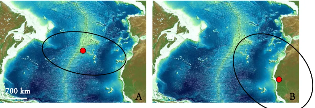
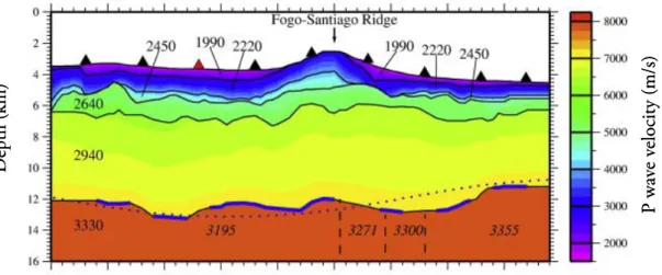
Figure 2.1 – A) Cape Verde Archipelago location in the Atlantic Ocean (image from topex.ucsd.edu); B) Detailed map of the Cape Verde Archipelago and constituting islands (image adapted from eoimages.gsfc.nasa.gov).
2.3. Geomorphologic characteristics
As in all volcanic islands, the morphology of the Cape Verde islands is dependent on the duality between constructive and destructive processes. The constructive events comprise volcanic activity and tectonic uplifting while the destructive processes involve wind, marine and stream erosion as well as mass movements and subsidence.
At the geomorphologic level the islands can be subdivided in two groups, those with a strong relief, where the volcanic edifices are the structures responsible for the main orographic characteristics (Santo Antão, São Nicolau, Santiago, Fogo and Brava), and those with extremely flat areas (São Vicente, Santa Luzia, Sal, Boavista and Maio) (Madeira et al., 2008). The maximum altitudes are observed on the islands of Fogo (2829 m), Santo Antão (1979 m) and Santiago (1392m). Maio, Boavista and Sal, located more to the East, are characterized by a more gentle terrain, testimony of an extensive and ongoing erosive process, the maximum altitudes not going over the 400 m (Assunção, 1968). On these islands the slopes tend to be
A 700 km
N Santo Antão
São Vicente
Santa Luzia São Nicolau Sal
Boavista Maio Santiago Fogo Brava 50 km N Santo Antão São Vicente
Santa Luzia São Nicolau Sal
Boavista Maio Santiago Fogo Brava Santo Antão São Vicente
Santa Luzia São Nicolau Sal
Boavista Maio Santiago Fogo Brava 50 km N B
13 lower, being the sedimentary depositional events more evident than the erosive ones (Mitchell-Thomé, 1976) (Fig. 2.2).
Figure 2.2 – Contrasting geomorphologic characteristics of the Cape Verde islands: A) Brava (photo by João Mata); B) Santiago; C) Maio (photo by João Mata); D) Sal (image from namma.msfc.nasa.gov). The West-East orography change (photo A to D) attesting the relief attenuation, from more recent to older islands with implicit magmatism migration.
The hydrographic network is restricted to short-lived streams, withstanding only two small rivers of permanent character in Santo Antão Island (Mitchell-Thomé, 1976). The absence of significant water lines comes from the low precipitation rate registered on the archipelago (3 to 20 days per year, in a study conducted between 1980-1987 on Santiago; Mannaerts and Gabriels, 2000) although, during storm events the rainfall can be very significant. This climatic situation is typical of sub-arid tropical regions.
A B
14
These sparse storm events are responsible for abrupt changes in the relief, particularly along cliffs and water courses. The presence of deep narrow gorges, waterfalls, steep longitudinal stream profiles are all indicative of water’s potential as an important modelling/erosional agent (Mitchell-Thomé, 1976). This author also points out the differences in the valley’s characteristics as a way of corroborating the age difference between the islands. The younger islands, located to the West (Santiago, Santo Antão, Brava) have steep walled gorged streams that flow straight to the sea, whereas the more mature islands to the East (Sal, Boavista, Maio) are characterized by broad streams, with abundant sediments that meander to the sea over longer distances.
Zazo et al. (2007) observed at Sal Island the existence of significant variations in sea level (eustatic) during the Quaternary, testified by the occurrence of numerous marine terraces that may reach 60 m a.p.s.l (above present sea level).
The study of sea level oscillations in the last 20-30 Ma is of extreme importance in deciphering the stratigraphic particularities present on several of the islands, as an example the occurrence of submarine lava flows at 450 m a.p.s.l. in Santiago Island (Serralheiro, 1976).
However, in order to assess the importance of crustal movements we must take into account information regarding sea-level changes. The Oligocene marks a major climatic change from a greenhouse world1
1Greenhouse-icehouse world refers to a super cycle with an approximate period of ≈ 300 Ma, which marks an
oscillation between two climatic extremes: the greenhouse world, were the poles were much warmer and temperature gradients were about half of the ones today, and the icehouse world with very cold poles and large temperature difference between poles and the equator (Plimer, 2003; Schlager, 2005).
to an icehouse world1 that remains until today. Eustatic changes of
about 30 to 60 m, are observed during the Oligocene and early Pliocene (~33.8 to 2.5 Ma) being explained by growth and decay of the ice coverage in Antarctica. More extreme sea levels changes (60 to 120 m) are inferred for the late Pliocene to Holocene (~2.5 to 0.0 Ma), being attributed to variations in large Northern Hemisphere Ice Sheets (NHIS) (Miller et al., 2005). The Mid-Pliocene is of particular interest because it stands as the most recent period significantly warmer than today. The explanation for this is still controversial (high CO2
concentrations, variations in oceanic circulation, increase in heat advection, etc.) but the consequences are recognized worldwide: reduced Arctic sea ice, elevated air temperatures at high altitudes, warmer sea surface temperature at mid-latitude and higher sea-level (Raymo et al., 1996; Haywood and Valdes, 2004; Fedorov et al., 2006).
15 During the Pliocene the maximum sea-level rise is about 80 m (Fig. 2.3) and so, the oddity of the occurrence of submarine lavas as high as 450 m a.p.s.l in some of the Cape Verde islands, as well as the occurrence of marine deposits at 120 a.p.s.l in the Canary Archipelago (Meco et al., 2007), must be explained by uplift in response to stress imposed in the lithosphere/upper mantle (tectonic-volcanic uprise) at a local and/or regional scale (Hardenbol et al., 1998). Another example of the magnitude of crustal movements in the archipelago is the emplacement of ocean floor fragments (outcropping MORBs) in the island of Maio and Santiago (Stillman et al., 1982, Gerlach et al., 1988).
Figure 2.3 - Eustatic sea level curve for the Cenozoic (a.p.s.l stands for above present sea level) (adapted from Hardenbol et al., 1998).
Ramalho et al. (2010a,b,c) made an extensive study concerning the vertical movements of uplift and subsidence in the Cape Verde Archipelago. In order to quantify and understand the significance of those movements specific sea-level palaeo-markers were used: submarine volcanic units, lava deltas, marine sediments and marine abrasion surfaces.
The uplift history of the Cape Verde islands is distinct and there are islands were no significant uplift was detected (Santo Antão, São Vicente, Santa Luzia and Fogo) whereas other experience significant positive vertical displacements reaching 450 m, 350 m and 280 m (Santiago, Brava and São Nicolau, respectively) (Ramalho et al., 2010c). The islands of Boavista and Maio also exhibit episodes of uplift and subsidence but less extreme. Sal Island is characterized by a variable series of old uplift movements (up to 350 m detected in the Ancient
16 El ev at ion (m) Sal -50 0 50 100 150 200 250 300 350 450 400
500 Santiago S.Nicolau Brava
Types of palaeo-markers
Quaternary terraces
In-sequence marine sediments Lava deltas
Submarine volcanic units
Maximum sea-level in the last 26 Ma Maximum sea-level during the quaternary
El ev at ion (m) Sal -50 0 50 100 150 200 250 300 350 450 400
500 Santiago S.Nicolau Brava
Types of palaeo-markers
Quaternary terraces
In-sequence marine sediments Lava deltas
Submarine volcanic units
Maximum sea-level in the last 26 Ma Maximum sea-level during the quaternary
erupted complex) and more recent subtle uplift and subsidence episodes already observed by Zazo et al. (2007) (Fig. 2.4).
Figure 2.4 – The most significant sea-levels heights inferred from the indicated palaeo-markers in the Cape Verde islands (adapted from Ramalho et al., 2010c).
The islands of Santiago and São Nicolau were studied further by Ramalho and co-authors (2010a, b) due to their significant and almost constant uplift. While São Nicolau experienced two distinct uplifting events one at 5.4 – 4.7 Ma and another at 0.5 – present, Santiago is characterized by a nearly constant uplift in the last 4 Ma at a rate of 100 m/Ma. These vertical movements appear to be synchronous with the volcanic activity responsible for the island growth. This observation along with the already stated disparity of uplift history among the archipelago led Ramalho et al. (2010a,b) to conclude that the most likely mechanism responsible for the observed uplift is regional at the scale of one individual island, most probably due to basal laccolith emplacement at crustal levels.
An uplift at the swell length scale in the period of 0.25 – 1.25 Ma was also identified, related with the building of the Cape Verde Rise but is small (100 m) compared with the above stated vertical movements of some specific islands (Ramalho et al., 2010a).
Main volcanic characteristics
The only volcanically active island in the archipelago is Fogo. On this island the last eruptions occurred in 1995, being the estimated total volume of erupted volcanic material 54 -
17 60x106 m3, during a period of 55 days (from 2nd of April until May 26), however there were
some twenty historical volcanic events dated back until 1664 (Torres et al., 1997a,b).
From the interpretation of volcanic products it is possible to infer that the predominant volcanic activity of the islands belongs to Hawaiian and/or strombolian style. The Hawaiian activity is characterized by the emission of fluid lavas that tend to erupt non-explosively due to the low viscosity nature of most of the predominant volcanic products, which correspond to basic-ultrabasic highly SiO2 undersaturated melts. Magmatism occurs essentially along fissures
or simple eruptive centers. Strombolian activity is related with discrete explosive events and is associated with less fluid lavas, ejected along an emission center. Pahoehoe and aa lava flows, as well as spatters and pyroclastic materials are the volcanic products associated with these eruptions types (Wallenstein et al., 1997).
It has been described in some of the islands (Santo Antão and Brava) extensive pumice deposits derived from large subplinian to plinian eruptions of more evolved magmas. In Santo Antão Island the Cão Grande deposit comprises phonolitic pumice lapilli material (up to 8.5 km thick) derived from the dispersion of a 30-34 km high column through a vent located on the westernmost side of the island (Mortensen et al., 2009). In Brava Island several surge deposits of phreato-magmatic and phreato-plinian origin were identified associated with the most recent magmatism (Madeira et al., 2008; 2010).
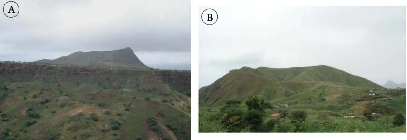
In some islands (Santiago, Brava, Santo Antão, Boavista) lava domes and plugs of traquitic/phonolitic affinity are also identified. The more viscous magmas tend to erupt pasty lava that has more difficulty in flowing, accumulating above the vent as a dome-shaped mass (Cas and Wright, 1987) (see Fig. 2.2A).
In some islands it can be identified levelled structures as “achadas”, “fajãs” and marine terraces. “Fajã” is a typical geomorphologic term widely used in Macaronésia, describing terrains most commonly present in shorelines, made up of lava flows or detritic sedimentary material. In the Cape Verde Islands, “achadas” are broadly present and correspond to flat areas between hills, particularly plateaus hanging between big central volcanoes.
18
As in many volcanic islands, calderas are also observed in the archipelago, the “Caldeira da Pedra Lume” (Sal Island), “Caldeira de Fundo Grande” (Brava Island) and the most noteworthy the “Caldeira do Fogo” (Fogo Island). This last one has a maximum diameter of 9 km, in the N-S direction, being characterized by step internal walls, almost vertical (“Bordeira”). The altitude difference between the “bordeira” top and the bottom of the caldera may reach 1000 m (Assunção, 1968) (Fig. 2.5).
Figure 2.5 – A) The Fogo summit volcano Fogo Island; B) “Caldeira do Fogo” characterized by high steep walls up to 1000 m (photos by Cyntia Mourão).
2.4. Geotectonic setting
As already referred the Cape Verde Islands form two distinct alignments converging eastwards, clearly different from what it would be theoretically expectable from the lithosphere drift over a mantle plume.
Bebiano (1932) and Assunção (1968) were the first to suggest the existence of important fracture zones controlling the positioning of the Cape Verde Islands. For them the alignment of most of the northern islands seems to suggest the presence of a deep WNW-ESE fracture zone, mimicking the West African coast fractures. Another well defined direction is the one marked by the islands grouped more to the East (Sal, Boavista e Maio), being N-S, more precisely NNE-SSW, which is also present on the African continent.
The WNW-ENE fracture is now known as the “Blake Spur Fracture Zone”, and passes south of the island of Santo Antão, between the islands of Boavista and Maio, prolonging to
19 1a 1b 1c 2 3 4 5 50 km 1a 1b 1c 2 3 4 5 1a 1b 1c 2 3 4 5 50 km 50 km
the Senegalese coast where it ends. This fracture zone corresponds to a remnant of a transform fault (Courtney and White, 1986). Williams et al. (1990) identified several fracture zones (about 13), around the Cape Verde Archipelago, based on magnetic lineation offsets. The average spacing is about 70 km and the predominant direction is WNW-ENE. These authors also stated that these features must be original Mesozoic seafloor fracture zones and not the product of the magmatic event responsible for the generation of the Cape Verde Islands.
On a more restricted area, near the islands, Torres (1998) identified the main hypothetical fractures that could be responsible for the peculiar disposition portrayed by the archipelago (Fig. 2.6). Fracture 1, with an N-S orientation was divided in three fragments, being 1b and 1c shifted segments due to the action of fractures 2 (Blake Spur Fracture Zone) and 3. The preferred orientation observed in dikes of Santo Antão and São Vicente, corresponds to the direction of maximum compression (N60ºE; fracture 4), also testified by the presence of two seamount NW of Santo Antão that mimics this direction (Banco do Noroeste). The recent volcanic activity on Sal Island has a NNE-SSW direction (fracture 5).
Figure 2.6 - Main fractures in the Cape Verde Archipelago (adapted from Torres, 1998): 1a, 1b,1c – Segments of a N-S fracture; 2- “Blake Spur Fracture Zone”; 3 – Fracture between the islands of Sal and Boavista; 4 – Mean orientation of dikes occurring in Santo Antão and S. Vicente; 5 – Alignment of the more recent volcanism in Sal (image from eoimages.gsfc.nasa.gov).
In a study preformed on the islands of Santo Antão, São Vicente, Sal, Maio, Santiago e Fogo, Scheidegger (2002) reports joint strike directions of NNW-SSE (154º-181º) and ENE-WSW (65º-81º), as the most common in the archipelago, noticing that these are similar to the
20
direction of the Mid-Atlantic ridge and the lineaments associated with it. Scheidegger (2002) also states that due to the fact that streams, joints and ridges directions agree with each other, this is probably the result of the action of the neotectonic stress field. These directions are in agreement with those reported by Torres (1998) for the alignment of magmatic activity (dikes and volcanic episodes, fractures 4 and 5 respectively).
Even though the Atlantic-type oceans margins are considered to be tectonically passive, recent studies (Skolotnev et al., 2007) around and south of the Cape Verde area (Cape Verde Ridge and Cape Verde Abyssal Plain) show evidence for tectonic movements that started in the Early Pliocene and prolonged in to the Quaternary. This conclusion was drawn due to observations in bottom topography and internal structures of sedimentary sequences as well as the identification of newly formed morphostructures (anticlines, horsts and diaper-like structures) (Skolotnev et al., 2007; 2009).
The seismic activity in the Cape Verde area is not very significant (Fig. 2.7A). Ever since seismic monitoring is available for this region, several earthquakes have been detected with a maximum magnitude of 6 (Matias et al., 1997). In the period between 1977 and 1989 (Fig. 2.7B) the seismic activity in the archipelago was centered to the west, where several alignments of epicenters have been identified which seem to suggest the presence of fracture zones oriented NW-SE and NNW-SSE in a sector comprising the islands of Santo Antão, São Vicente, Fogo and Brava (Brum da Silveira et al., 1997).
More recently Grevemeyer et al. (2010) stated that the Cadamosto seamount, a 3 km high submarine volcanic edifice, is the seismically most active feature in the archipelago (see Fig. 2.8). During the Meteor M62/3 cruise (summer 2004) several local volcano-tectonic earthquakes were detected and attributed to rock failure due to dike injection/intrusion. The data recovered in the 2004 cruise, in the Fogo-Brava-Cadamosto area, suggest that the seismic and most probably the volcanic activity is moving away from Fogo and centering in the Cadamosto seamount, which could lead, in the future, to a new island (Grevemeyer et al., 2004; 2010).
21
Figure 2.7 - A) Seismicity of the North Atlantic Ocean between 1975 and 1995 (from earthquake.usgs.gov); B) Seismic activity registered between 1977 and 1989 (adapted from Brum da Silveira et al., 1997).
Figure 2.8 – Seismicity detected at the Cadamosto seamount during the cruise M62/3 of the German R/V Meteor (red dots represent local earthquakes) (image adapted from Grevemeyer et al., 2010)
2.5. Geodynamic context
The Cape Verde Archipelago is the result of intraplate magmatism in the West African plate in the central Atlantic Ocean. The geotectonic setting of the African plate imprints
0º 20º 40º 60º -60º -40º -20º 0º 0º 20º 40º 60º -60º -40º -20º 0º A B
22 700 km
A
B
700 km 700 kmA
B
specific characteristics on the islands implanted on it. Even though the most plausible mechanism responsible for the generation of the Cape Verde Archipelago is a mantle plume of deep origin, in accordance with that proposed for other intraplate magmatism in the Atlantic Ocean, there is still some debate around it, which is closely related with the discussion of existence/absence of those structures in the mantle elsewhere and in the Cape Verde region in particular. For Cape Verde this uncertainty is enhanced by the lack of a single linear trend concerning the islands distribution.
The Mid-Atlantic Ridge is characterized by slow spreading rates (20 ± 1 mm/year; O’Connor et al., 1999), compared to the Pacific fast spreading rate (80-180 mm/year; Dick et al., 2003). The absolute plate motion of the African plate, in particular, has changed at 6 Ma (gradually along 8 to 4 Ma), from a situation of counterclockwise rotation around a pole at 33ºN, 35ºW (period of 30 - 6 Ma) to a counterclockwise rotation at a pole situated at 19ºN, 16ºW (6 - 0 Ma) (Pollitz, 1991)(Fig. 2.9).
Figure 2.9 – Location of African absolute motion poles in the period of 30-6 Ma (A) and 6-0 Ma (B) (adapted from Pollitz, 1991; image from www.geoware-online.com).
Holm et al. (2008) made a compilation of several data regarding the motion of the African plate at the Cape Verde Archipelago and estimated an average dislocation of the plate to NE at a rate of 9 mm/year during the last 6 Ma.
According to Silver et al. (1998) the cause for deceleration of the African plate, around 30 Ma, is probably due to its collision with the Eurasian plate, which stands as the largest and slowest moving plate. This was counterbalanced by an acceleration of the South Africa plate,
23
The uplift is a consequence of diffuse heating at the base of the lithosphere, which leads to thermal expansion in order to attain equilibrium thermal structure (Cserepes et al., 2000; DeLaughter et al., 2005).
Dynamic support is associated with hot and less dense material moving within the asthenosphere and lithosphere, which applies a dynamic pressure for enabling the flow of the material supplied by the plume (Sleep, 1990). Most of the reheating is at the base of the lithosphere (Stein amd Von Herzen, 2007).
Swell formation is explained by the presence of a buoyant low-density mantle residue left behind after the extraction of melt through volcanism (chemical compositional buoyancy, Laske et al., 2007) or due to the original buoyancy of the anomalously hot material (Schubert et al., 2001). Thermal rejuvenation
Compositional Buoyancy
Dynamic support
which promoted the increase in cordilleran activity in the west zone of the plate. Also, within this time frame, there was an increase in hotspot magmatism across the African plate, which can be attributed to the almost stationary character of the plate which caused an increase in lithosphere heating due to a prolonged influence of mantle plumes (O’Connor et al., 1999).
The Cape Verde Archipelago is implanted on the largest amplitude oceanic swell on Earth being associated with several geophysical particularities which are going to be described next. The interpretation of these geophysical parameters enables the clarification of the process (or processes) susceptible of causing the observed swell (Fig. 2.10) and give information about the crustal and mantle structure.
24
B
A
2.5.1. Geophysical particularities of the Cape Verde area 2.5.1.1. Topography
The Cape Verde islands are implanted in old oceanic crust between M21 and M0 magnetic anomalies (120-140 Ma; Hayes and Rabinowitz, 1975), and are associated with the Cape Verde Rise, one of the largest swell on the ocean basins that ascends 2.2 km above what would be expected for ocean floor of Jurassic-Cretaceous age, according to half-space cooling model (seafloor depth increases approximately as the square root of lithosphere age; Davis and Lister, 1974). The Cape Verde Rise has an E-W orientation with a horizontal distance of 600 km, in diameter, which is vertically limited by the 3700 m bathymetric line (Courtney and White, 1986) (Fig. 2.11). If the northwester bulge, centered at 20ºN-30ºW (marked as a star in Fig. 2.11) is considered as part as the Cape Verde Rise (Crough, 1982), then its wide increases until 1200-1600 km, in diameter.
Figure 2.11 – Basement map of the Central Atlantic Ocean (calculated from extracting the sediment thickness from the topography) (Patriat and Labails, 2006). A and B correspond to the location of the highest and lowest heat flow measurement respectively, determined by Courtney and White (1986).
25 2.5.1.2. Heat flow anomaly
Several models of lithospheric thermal evolution have been presented since the seventies when Davis and Lister (1974) introduced the half space model (e.g., Parson and Sclater, 1977; Stein and Stein, 1992). These are important because they provide a reference model of average variation in depth and heat flow with age of normal lithosphere, thus allowing the identification of uncharacteristic zones that deviate from the standard. The dome where the Cape Verde islands are implanted is characterized by a broad heat flow anomaly, with a maximum excess heat of 17 ± 3.7 mW/m2 at the centre of the swell that drop to lower values
towards the flanks. The highest measured value was 60.5 ± 4.0 mW/m2 (see A in Fig. 2.11)
and the lowest 43.5 ± 3.4 mW/m2 (see B in Fig. 2.11) (Courtney and White, 1986).
Considering that the normal heat flow in ocean floor with the same age as the Cape Verde
Rise (≈ 125 Ma) is 50 mW/m2, according to the Global Depth and Heat flow model (GDH1)
by Stein and Stein (1992), the observed thermal anomaly is approximately 10 mW/m2 and the
corresponding depth anomaly is 285 m (assuming that ≈ 60 mW/m2 heat flow corresponds to
a lithospheric thermal age of 69 Ma) (Stein and Stein, 1993). Considering that the total depth anomaly is 2200 m, the fraction endorsed to thermal rejuvenation is only 13%. The remaining uplift is probably caused by dynamic support due to the impingement of ascending hot asthenospheric material (i.e., mantle plume) in sublithospheric domains (Sleep, 1990; Zhong and Watts, 2002).
It is important to state that the determined thermal anomaly is directly related to the chosen reference model since it establishes the guidelines for what is considered a normal lithosphere.
Another important aspect described by Von Herzen (2004) and Harris and McNutt (2007) is the possibility that the scatter observed in the regional heat flow surveys, including the one done by Courtney and White (1986) in the Cape Verde Rise (Fig. 2.12), is the result of heat loss by advection due to hydrothermal convective circulation. Even though this mechanism is thought to be inexistent beyond the 65 Ma “sealing age” the large variations observed suggest fluid flow in crust of Cretaceous age (Harris and McNutt, 2007 and references therein). The driving mechanism seems to be bathymetric relief of the volcanic
26
edifices. Considering this alternative there is the possibility that a component of basal heat flow is not being accounted for (Harris and McNutt, 2007).
Figure 2.12 – Heat flow data of site A (see Fig 2.11) in the Cape Verde Rise, being evident the scatter of the measurements within one survey station. Error bars represent standard deviation (from Harris and McNutt, 2007).
2.5.1.3. Geoid and gravity anomalies
The geoid is the gravitacional equipotencial surface of the Earth, coinciding with sea-level in oceanic areas. Deviations of the geoid from an idealized hydrostatic ellipsoid are known as geoid anomalies and are the result of the existence of mass heterogeneity distribution inside the Earth (see Fig. 2.13). While geoid anomalies decrease inversely with distance to source mass, gravity anomalies decreases inversely with the square of distance. For this reason gravity anomalies are particularly susceptible to mass changes at crustal levels while geoid anomalies provides a long-range probe in a wide range of depths (Condie, 2001; Li and Götze, 2001; Urchulutegui, 2007).
Crough (1982) reported geoid height anomalies, determined by satellite altimetry, for the Cape Verde Rise and also presented residual geoid anomalies, after the regional field had been subtracted of the original measured values. The value obtained is the difference between the positive geoid anomaly for the excess topography and the negative geoid anomaly from the density deficiency at depth (Sleep, 1990). The Cape Verde Rise is characterized by a residual geoid height with a central high at 16ºN-25ºW (>8.0 m) and a smaller bulge at 20ºN-30ºW (>
27
G
eoid Geoid
Sea Level
Sea Level
Positive mass anomaly Negative mass anomaly
G
eoid Geoid
Sea Level
Sea Level
Positive mass anomaly Negative mass anomaly
5.0 m) (Fig. 2.14). Such anomaly, indicating a low mass domain beneath Cape Verde Archipelago is compatible with an upward flow caused by a mantle plume.
Figure 2.13 - Effects of positive and negative mass anomalies on the geoid. Owing to its ductile behaviour, the mantle can deform. A positive mass anomaly causes a downward flow in the mantle producing a depression on the surface of the planet with the resulting replacement of rock by air or seawater. So the depression can be regarded as a mass deficiency relative to a laterally uniform Earth, which results in a negative geoid anomaly. A negative mass anomaly causes the opposite effect (Condie, 2005) (figures adapted from Condie, 2005).
Figure 2.14 - Geoid height anomaly observed at the Cape Verde Rise (adapted from Crough, 1982).
The existence of such negative mass anomaly beneath Cape Verde is also demonstrated by gravity anomalies. The measured residual gravimetric anomalies reflect the gravity balance between the material in, and below, the crust which is intrinsically associated with their density