Versão online: http://www.lneg.pt/iedt/unidades/16/paginas/26/30/185 Comunicações Geológicas (2014) 101, Especial III, 1461-1465
IX CNG/2º CoGePLiP, Porto 2014 ISSN: 0873-948X; e-ISSN: 1647-581X
A synthesis of Doñana National Park (Spain) Late Holocene
history: palaeoenvironmental evolution, climate influence, high
energy events and foraminifera records
Síntese da história da Evolução Holocénica do Parque Nacional
de Doñana (Espanha): evolução paleoambiental, influência
climática, eventos energéticos extremos e registro de
foraminíferos
L. Guerra1, C. Veiga-Pires1, F. Ruiz2, M. Abad3 © 2014 LNEG – Laboratório Nacional de Geologia e Energia IP
Abstract: The present work aims to make a synthesis of the palaeogeographical evolution of Doñana National Park, through a compilation of previously published information on this subject including the general description of Late Holocene Climatic Change in the Iberian Peninsula. Sedimentological and microfaunal data from two cores and historical records of high-energy events in Portugal and Spain are also combined and discussed in relation to the recognition of climatic intervals and tsunami events. Results show that the palaeogeographical evolution of Doñana National Park seems indeed mostly linked to Climatic Changes and occurrence of high energy events as observed for the tsunami of 2168-2159 B.P., during the Sub-Atlantic period.
Keywords: Holocene, Foraminifera, Palaeogeographical Evolution, Doñana National Park, Southwestern Spain.
Resumo: O presente trabalho tem como objectivo realizar uma síntese da evolução paleogeográfica do Parque Nacional de Doñana, através de uma compilação da informação previamente publicada sobre o assunto, incluindo a descrição geral das variações climáticas tardi-holocénicas na Península Ibérica. Dados sedimentológicos e de microfauna de dois cores e o registo histórico de eventos energéticos extremos em Portugal e Espanha são igualmente combinados e discutidos no que diz respeito ao reconhecimento dos intervalos climáticos e eventos tsunamigénicos. Os resultados mostram que a evolução paleogeográfica do Parque Nacional de Doñana parece certamente ligada às mudanças climáticas e à ocorrência de eventos energéticos extremos como observado para o tsunami de 2168-2159 B.P., durante o período Sub-Atlântico.
Palavras-chave: Holocénico, Foraminíferos, Evolução
paleogeográfica, Parque Nacional de Doñana, Sudoeste de Espanha.
1CIMA-FCT, Universidade do Algarve, Campus de Gambelas, 8005-139 Faro,
Portugal.
2Departamento de Geodinámica y Paleontología, Univ. de Huelva, Avda.
Fuerzas Armadas, s/n. 21071-Huelva, Spain.
3Departamento de Geología, Univ. de Atacama, Avda. Copayapu 485,
Copiapó-Chile.
*Corresponding author / Autor correspondente: a40955@ualg.pt
1. Introduction
Doñana National Park (DNP) is one of the largest wetlands (~500 km2) in Europe, located in southwestern Spain (Fig. 1).
The Park is mainly composed of salt and freshwater marshes that include temporary ponds. These marshes are drained by several tributaries and numerous ebb tide channels, with recent and ancient banks defined by clayey levees, bioclastic and beach-like sandy ridges (Fig. 1b: Las Nuevas). In addition, these marginal formations are locally covered by sandy ridges aligned in an NE-SW orientation nearby to the Doñana spit barrier (Fig. 1b: Vetalengua). These inner zones are protected by two littoral spit-barrier systems (Doñana and La Algaida) composed of active dunes assembled in narrow and elongated sandy strips (Rodríguez-Vidal et al., 2011).
Guadalquivir fluvial regime, tidal inputs, the dominant southwesterly wave action and the southeasterly drift currents are controlling the main hydrodynamic processes within the present.
At least sixteen tsunamis have been documented for the time-period between 2168-2159 B.P. (218 BC and 1900 AD) (Campos, 1991). These high-energy events had tremendous morphological effects and drastic ecological impacts in coastal areas (Borrero, 2005) and caused the deposition of sedimentary beds with characteristic textural and mineralogical features (e.g., Babu et al., 2007) (Fig. 1b and c: Cheniers).
The present work aims to present a bibliographic revision of the DNP palaeogeographical evolution during the Late Holocene and to compile and integrate it with other information such as Climatic Changes as well as sedimentary and new micropaleontological data from two cores.
2. Methods
A bibliographic revision was carried on in order to integrate several type of information: i) DNP paleogeographical evolution, ii) Late-Holocene Climatic phases, and iii)
Artigo Curto Short Article
Occurrence of Tsunami events. This synthesis also aims to redraw maps of the palaeogeographical evolution of DNP (Fig. 2), based on Rodríguez-Ramírez (2008), using ArcGIS software, as well as the positioning of the sampled cores.
On the other hand, Las Nuevas area (Fig. 1b) was selected for collecting two cores, once it contains the main geomorphological features of the estuary (Fig. 1b, see Ruiz et
al., 2004 for more details on sampling). Approximately 62
samples (15 g) were taken for microfossil analysis, as they were selected according to the main sedimentary changes observed in the core. These samples were washed through a 63 μm sieve to remove the mud fraction and then dried.
If possible, more than 300 benthic foraminifera from each sample were picked and identified onto faunal microscope slides. The number of planktonic foraminifera in each sample was also taken into account, for latter calculation of the ratio planktonic/benthic foraminifera (individuals/gram) (Fig. 3).
Fig. 1. a) Location of Doñana National Park in the Iberian Peninsula, b) Doñana National Park main geomorphology and core sampling sites, c) Topographic profile between sampled cores C-D.
Fig. 1. a) Localização do Parque Nacional de Doñana na Península Ibérica, b) Geomorfologia geral do Parque Nacional de Doñana e locais de amostragem dos cores, c)Perfil topográfico entre os cores C-D. 3. Results and discussion
3.1. Climate and palaeoenvironmental evolution of Doñana National Park
The palaeogeographical evolution of DNP has already been described by many authors, like Ruiz et al., 2010, who included numerous data obtained by Lario (1996) and Zazo
et al. (1999) in several cores from DNP; as well as previous
analyses of short cores by Ruiz et al. (2004).
The palaeogeographical evolution of DNP presented here is further complemented with Late Holocene Climate Change phases over the Iberian Peninsula (Schütt, 2005) since the “Atlantic period” to the “SubAtlantic period to present”, and the historical records of high-energy events in Portugal and southern Spain (Galbis, 1932; Campos, 1991).
Atlantic period
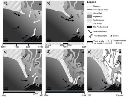
During the Atlantic period (8000 B.P. to 6000-5000 B.P.) the Iberian Peninsula was under the influence of the subtropical high-pressure belt in the summer months, whereas the impacts of the west wind drift shift to higher latitudes (Lamb, 1971). This period corresponds to phases 4 and 5 described by Ruiz et al. (2010) during which the Cádiz Gulf-river mouths were inundated around 6.5 cal ka (Dabrio et al., 2000) and DNP was occupied by an open lagoon, partially protected in its westernmost part by aeolian units (Zazo et al., 2008) (Fig. 2a).
After this maximum transgression, the Doñana spit began to grow (Goy et al., 1996). The bottom sediments of the adjacent, quiet lagoon were composed of clayey silt (FA-3, Fig. 3) with variable bioclastic contents. Between 5100 and 4800 cal BP, there is a tsunami record causing the erosion of this spit and the deposition of aeolian sand over the new salt marsh (Fig. 2b) (Ruiz et al., 2010).
Sub Boreal period
After the end of the “postglacial climate optimum” and slight global cooling, there was a temporary southward shift of the northern hemispheric high west wind drift during the Sub-Boreal period (5000–3000 B.P.). As a result of the increasing meridional temperature gradient the circulation gained a stronger zonal component (Lamb, 1971). The west wind weather conditions now prevailing over the Iberian Peninsula between autumn and spring brought rain to all parts of it, improving the water balance.
Phases 6 and 7 of Ruiz et al., 2010 are included in this period, during which the central part of the DNP was still occupied by an open lagoon, whereas the Doñana spit grew towards the southeast (Fig. 2b and 2c). There is record of one or two tsunami-like events (or very strong storms) that caused the erosion of the Doñana spit (3700-3000 B.P.; Fig. 2b) and the deposition of bioclastic, sandy-clayey silt over the lagoon bottom. In a latter period, new high-energy events induced the emersion of the very shallow, southwestern areas of the lagoon, with the deposits of bioclastic silt and sand (FA-5, Fig. 3) overlying intertidal sediments.
Sub Atlantic period
During the Sub-Atlantic period (3000-1500 B.P.), climate involved towards global warming (Dansgaard et al., 1969) and generally wetter conditions in central Europe. During this phase the Iberian Peninsula remained under the influence of Atlantic-cyclonic conditions (Lamb, 1971). However, generally higher temperatures resulted in deteriorating water balance conditions and an Iberian continental semi-arid climate prevailed in central Iberia.
Then global cooling brought a temporary rise in humidity over the Iberian Peninsula.
Fig. 2. Palaeogeographical evolution maps adapted from Rodríguez-Ramírez (2008) and showing paleogeographical environments during a) the Atlantic Climatic period, b) the Sub-Boreal Climatic period and, c)-e) the Sub-Atlantic Climatic period until present.
Fig. 2. Mapas da evolução paleogeográfica adaptados de Rodríguez-Ramírez (2008) e mostrando os ambientes paleogeográficos durante a) o período climático Atlântico, b) o período climático Sub-Boreal, c)-e) o período climático Sub-Atlântico até ao presente.
Fig. 3. Synthetic sketch correlating the two cores facies and associated paleoenvironment descriptions (Ruiz et al., 2004), with the Climatic Periods (Schütt, 2005) and the Foraminiferal ratio (this study).
Fig. 3. Esquema sintético correlacionando facies de dois cores e descrições paleoambientais associadas (Ruiz et al., 2004), com os períodos climáticos (Schütt, 2005) e ratio de foraminíferos (presente estudo).
The Sub-Atlantic period includes phases 8 to 10 of Ruiz et al. (2010) palaeoreconstruction, during which the southwestern part of the DNP area remained emerged, between 3000-2200 B.P., whereas the central and southern ones were occupied by a very shallow lagoon (Fig. 2c). The continuous growing of the Doñana spit and the progressive infilling induced the creation of new brackish marshes (Zazo et al., 1999) and the transition from marine conditions to more restricted scenarios (Ruiz et al., 2010).
During 2200-1900 B.P. several tsunamis eroded the Doñana spit (Fig. 2c) with the creation of small washover fans constituted by aeolian sediments and bioclastic accumulation ridges over the lagoon margins (Ruiz et al., 2010).
These tsunamis may be assimilated to the historical tsunamis that devastated the southwestern Iberian coasts between 2168-2159 B.P. and 2010 B.P. (218-209 BC and 60 BC) (Campos, 1991).
From 1900 B.P. to present times, there was an increasing infilling of the lagoon (Fig. 2d). This tendency was interrupted by a new introduction of marine and aeolian sediments in the southern part of the park, owing to new high-energy events (Ruiz et al., 2010). Ages of these phenomena coincide with those of an historical tsunami (1568 B.P.=382 BC; Campos, 1991). The posterior palaeoenvironmental evolution of the DNP (Fig. 2e) is marked by the creation of new wetlands with temporary ponds and the growing of the Doñana and La Algaida spits, with aeolian sands covering intertidal sediments.
3.2. Sedimentary and micropaleontological data
Figure 3 illustrates the relation between the facies of cores C and D (Fig. 1), the ratio of planktonic/benthic foraminifera (n/g) along each core and an interpretation of the Holocene Climate Change phases’ on the Iberian Peninsula.
The Atlantic period (Fig. 2a) is not recorded in cores C and D. During the Sub Boreal period (Fig. 2b), the planktonic/benthic foraminifera ratio reaches its highest values of 2.16 (Fig. 3) in the lower 30 cm of core D, indicating a strong marine influence and agreeing with the description of a lagoon environment by Ruiz et al. (2004). This also goes in agreement with the description of the Sub Boreal climate (see previous section).
During the Sub Atlantic period (Fig. 2c-e) the planktonic/benthic foraminifera ratio shows lower values in both cores C (from 90 cm to the top) and D (from ~130 cm to the top), with some non- significant variations, indicating a more restricted environment than the latest. These results go accordingly to the description of a shallow lagoon or saltmarsh environment made by Ruiz et al. (2004). Although the facies and carbon ages concur with the sedimentary signature of high energy events and the record of the historical tsunamis respectively, no evidence of these events is found in the planktonic/benthic ratio of the cores.
4. Conclusions
Palaeogeographical evolution of Doñana NP seems mostly linked to Climatic Changes and the occurrence of high energy events. Although there is no record of the Atlantic period climate on the analyzed cores at the present work, the Sub Boreal and Sub Atlantic periods are well recorded (Fig. 2 and 3). Furthermore, although planktonic/benthic foraminifera ratios seem a reliable marine influence indicator, they do not provide information on tsunami or storm occurrence. The record of benthic foraminifera assemblages in the cores samples and at present surface samples may be an helpful assess to evidence this high-energy events.
Acknowledgments
This research was partially funded by Spanish–FEDER Projects CGL2012-30875, FCT Project (PTDC/CTE-GIX/110205/2009), CIMA strategic project
PEst-OE/MAR/UI0350/2011, MAPFRE Foundation
TSUNAONUBA Project and three Research Groups of the Andalusia Board (RNM-238, RNM-293, and RNM-349). References
Babu, N., Suresh Babu, D.S., Mohan Das, P.N., 2007. Impact of tsunami on texture and mineralogy of a major placer deposit in southwest coast of India. Environmental Geology, 52, 71-80. Borrero, J.C., 2005. Field data and satellite imagery of tsunami
effects in Banda Aceh. Science, 308, 1596.
Campos, M.L., 1991. Tsunami hazard on the Spanish coasts of the Iberian Peninsula. Science of Tsunami Hazards, 9, 83-90. Dabrio, C.J., Zazo, C., Lario, J., Goy, J.L., Sierro, F.J., Borja, F.,
González, J.A., Flores, J.A., 2000. Depositional history of estuarine infill during the last postglacial transgression (Gulf of Cadiz, southern Spain). Marine Geology, 162, 381-404.
Dansgaard, W., Johnsen S.J., Møller, J., 1969. One thousand Centuries of Climatic Record from Camp Century on the Greenland Ice Sheet. Science, 166, 377-381.
Galbis, R.J., 1932. Catálogo sísmico de la zona comprendida entre los meridianos 58E y 208W de Greenwich y los paralelos 45º y 25º N. Dirección General del Instituto Geográfico, Catastral y de Estadística, Madrid.
Goy, J.L., Zazo, C., Dabrio, C.J., Lario, J., Borja, F., Sierro, F.J., Flores, J.A., 1996. Global and regional factors controlling changes of coastlines in southern Iberia (Spain) during the Holocene. Quaternary Science Reviews, 15, 773-780.
Lamb, H.H., 1971. Climates and Circulation Re-gimes Developed over the Northern Hemisphere during and since the Last Ice Age. Palaeogeography, Palaeoclimatology, Palaeoecology, 10, 125-162. Lario, J., 1996. Último y Presente Interglacial en el área de conexión
Atlántico- Mediterráneo: variaciones del nivel del mar, paleoclima y paleoambientes. PhD Thesis, Universidad Complutense de Madrid (unpublished), 269 p.
Rodríguez-Ramírez, 2008. Geomorfología del Parque Nacional de Doñana. Geología de Huelva: lugares de interés geológico. Universidad de Huelva, 146-151.
Rodríguez-Vidal, J., Ruiz, F., Cáceres, M.A., González-Regalado, M.L., Pozo, M., Carretero, M.I., Soares, A.M., Gómez Toscano, F., 2011. Geomarkers of the 218-209 BC Atlantic tsunami in the Roman Lacus Ligustinus (SW Spain): A palaeogeographical approach. Quaternary International, 242, 201-212.
Ruiz, F., Pozo, M.,Carretero, M.I., Abad, M., González-Regalado, M.L., Muñoz, J.M. , Rodríguez-Vidal, J., Cáceres, L.M., Pendón, J.G., Prudêncio, M.I., Dias, M.I., 2010. Birth, evolution and death of a lagoon: Late Pleistocene to Holocene palaeoenvironmental reconstruction of the Doñana National Park (SW Spain). Lagoons: Biology, Management and Environmental Impact, 1-26.
Ruiz, F., Rodríguez-Ramírez, A., Cáceres, L.M., Rodríguez Vidal, J., Carretero, M.I., Clemente, L., Muñoz, J.M., Yañez, C., Abad, M., 2004. Late Holocene evolution of the southwestern Doñana Nacional Park (Guadalquivir Estuary, SW Spain): a multivariate approach. Palaeogeography, Palaeoclimatology, Palaeoecology, 204, 47-64.
Schütt, B., 2005. Late Quaternary Environmental Change on the Iberian Peninsula. Die Erde, 136, 3-14.
Zazo, C., Dabrio, C.J., Goy, J.L., Lario, J., Cabero, A., Silva, P.G., Bardají, T., Mercier, N., Borja, F., Roquero, E., 2008. The coastal archives of the last 15 ka in the Atlantic-Mediterranean Spanish linkage area: Sea level and climate changes. Quaternary International, 181, 72-87.
Zazo, C., Dabrio, C.J., González, A., Sierro, F.J., Yll, E.I., Goy, J.L., Luque, L., Pantaleón-Cano, J., Soler, V., Roure, J.M., Hoyos, M., Borja, F., 1999. The record of the later glacial and interglacial periods in the Guadalquivir marshlands (Mari López drilling, S. W. Spain). Geogaceta, 26, 119-122.