MORPHOMETRIC COMPARTMENTATION OF THE COCO RIVER
BASIN AS SUBSIDY TO ANALYSIS OF ENVIRONMENTAL FRAGILITY
compartimentação morfométrica da bacia do Rio do Coco como subsídio a análise de fragilidade ambiental
Rejane Freitas Benevides Almeida *
Maximiliano Bayer **
Laerte Guimarães Ferreira Júnior ***
Resumo
O presente estudo teve como objetivo realizar a compartimentação morfométrica da Bacia Hidrográica do Rio Coco. Para tanto, foi realizada a digitalização manual da hidrograia na escala 1:5.000 no ArcGis 10.1
a partir de imagens do satélite RapidEye, sendo utilizada a metodologia proposta por Strahler (1952) para a
hierarquização da rede de drenagem. A compartimentação da bacia foi realizada no ArcGis 10.1 com base em análises da drenagem na paisagem (hidrograia e relevo). Foram deinidos 05 compartimentos (sub-bacias), sendo: bacia do Ribeirão Prata, bacia do Ribeirão Piedade, bacia do Ribeirão Surubim, Sub--bacia do Alto Rio Coco e SubSub--bacia do Baixo Rio Coco, para os quais foram aplicados parâmetros morfo-métricos, conforme as metodologias descritas por Horton (1945), Christofoletti (1969) e Strahler (1952). A partir da análise realizada pode-se observar que as sub-bacias do Alto Rio Coco e Ribeirão Piedade foram
os compartimentos que apresentaram maiores fragilidades naturais em relação aos demais compartimentos,
haja vista os resultados veriicados na análise morfométrica realizada, sugerindo uma atenção especial às
mesmas em relação ao uso e ocupação do solo.
Palavras-chave: Compartimentação morfométrica; Fragilidade ambiental; Bacia do Rio Coco.
Abstract
This study had as its object realizes the morphometric compartmentation of the Coco River basin. For this, it
was performed the manual digitization of the drainage at scale 1:5,000 from RapidEye satellite images using
ArcGIS 10.1, being used the methodology proposed by Strahler (1952) for the hierarchy of the drainage. The compartmentalization the basin it was performed in ArcGis 10.1 based on drainage analysis in the landscape (hydrograph and relief). Were deined 05 compartments (sub-basins), being: Sub-basin the Ribeirão Prata, basin the Ribeirão Piedade, basin the Ribeirão Surubim, basin the High Coco River and Sub--basin the Low Coco River, in which were applied morphometric parameters, according the methodologies described by Horton (1945), Christofoletti (1969) and Strahler (1952). From the analysis performed can be observed that the sub-basins the High Coco River and Ribeirão Piedade were the compartments that
showed largest natural fragility in relation the other compartments, considering the results obtained in the morphometric analysis, suggesting a special attention to them in relation the use and occupation of soil.
Key words: Morphometric compartmentation; Environmental fragility; Coco River Basin.
Resumen
El presente estudio tuvo como objetivo realizar la compartimentación morfométrica de la Cuenca Hidrográ
-ica del Rio Coco. Para esto, fue realizada la digitalización manual de la red hidrográ-ica en escala 1:5.000 en ArcGis 10.1 a partir de imágenes do satélite RapidEye, siendo utilizada la metodología propuesta por Strahler (1952) para la jerarquización de la red de drenaje. La compartimentación de la cuenca fue realizada en el programa ArcGis 10.1 con base en el análisis del drenaje y el paisaje (hidrografía e relieve). Fueron deinidos 05 compartimientos (sub-cuencas), siendo: Sub-cuenca del Ribeirão Prata, Sub-cuenca del Ribei-rão Piedade, Sub-cuenca del RibeiRibei-rão Surubim, Sub-cuenca del Alto Rio Coco y Sub-cuenca del Bajo Rio Coco, para los cuales fueron aplicados parámetros morfométricos, conforme las metodologías descriptas en los trabajos de Horton (1945), Christofoletti (1969) y Strahler (1952). A partir del análisis realizado se puede observar que las sub-cuencas del Alto Rio Coco y del Ribeirão Piedade fueron los compartimientos que presentaron mayores fragilidades naturales en relación a las demás sub-cuencas, situación veriicada con
los resultados del análisis morfométrico realizado, requiriendo por tanto una atención especial en relación al uso y ocupación del suelo.
Palabras claves: Compartimentación morfométrica; Fragilidad ambiental; Cuenca hidrográica del Río Coco.
(*) Phd Student Federal University of Goiás (Universidade Federal de Goiás) - Povoado Santana, Setor Industrial, CEP: 77600000, Paraiso do Tocantins (TO), Brasil. Tel: (+ 55 63) 33617002 – [email protected]
(**) Lecturer, Phd Federal University of Goiás (Universidade Federal de Goiás) - Campus II Samambaia, CEP: 74001970, Goiânia (GO), Brasil. Tel: (+55 62) 35211184 – [email protected]
84
INTRODUCTION
The morphometry of hydrographic basins is understood as a quantitative analysis of the resul
-ting elements of modeled relief (expression and spatial coniguration) (SALLES, 2010, p. 05). For Soares and Souza (2012, p. 20), this type of analysis enables the identiication of important general
characteristics in a basin, especially when considering the relationship of the geomorphological characteristics associated with relief and drainage network.
The researches in hydrographic basins facilitate the monitoring of natural changes or introdu
-ced by man (RODRIGUES, PISSARRA e CAMPUS, 2008, p. 311), and its delimitation one of the irst and most common procedures performed in hydrological or environmental analysis (ARAÚJO, TELES e LAGO, 2009, p. 4631). Thus, morphometric analysis plays an important role in studies
involving basin, as it enables a systematic evaluation of the physical aspects of a basin and a better
understanding of the dynamic of resources (FREIRE, LAGE e CHRISTÓFARO, 2013, p. 5443). According to Nunes, Ribeiro and Fiori (2006, p. 01), the morphometric study of hydrographic basins is deined as the quantitative analysis of the relationship between the physical geography of the basin and its hydrological dynamics. Barbosa and Ferreira (2012, p. 112) discuss that the
morphological and morphometric characterization of an area allow to know the natural potential
existing in it, facilitating the identiication of occupancy risk areas, fragile environments,
environ-mental impacts, human interference and the dynamics of the natural evolution of the landscape. The morphometric analysis has a close relationship with geography, since it allows unders -tanding, through a set of morphometric parameters that relate to a list of geographic features, the
dynamics of the basin as a whole, including its diferent compartments and consequently its natural
fragility.
Identify the environmental fragility of a basin means assessing, irst through isolated analysis
of indicators of relevant physical aspects of the environment under study, and later crosses of these,
the intensity with which this environment can be exploited without harming its dynamics and its
balance, taking into consideration the limitations imposed on him by the natural and anthropogenic
components (GHEZZI, 2003, p. 02).
It is important to note that this assessment becomes important, since it allows to assess the
natural vulnerability of a basin, which according to Souza (2005, p. 52) corresponds to the degree of probability that the natural attributes have in conditioning, induce or accelerate the occurrence of a particular hazard. The author evaluates the morphometric susceptibility of drainage basins as the parcel of responsibility of the geometric behavior of the basins in triggering of problems, such
as loods, erosion, landslides, among others.
Ghezzi (2003, p. 08) points out that through the study of the fragility can be identiied the vul-nerability of an environment to some kind of use or occupation, either by result of their exploitation
by either own natural factors. His study aims to observe how an environment, which of course can present degrees of fragility, behaves or may behave with the advent of human interference.
Therefore, the morphometric characterization of a hydrographic basin is one of the irst and
most common procedures performed in hydrological or environmental analysis, and aims to eluci -date the various issues related to the understanding of local and regional environmental dynamics
(TEODORO et al., 2007, p. 137).
In this sense, the present study aimed the analysis and morphometric compartmentalization of
Coco River Basin as an aid to analysis of environmental fragility, in search of a more embracing
understanding of how natural processes can be inluenced by the uses and occupations imposed in
85 STUDY AREA
This study was developed at the Coco River Basin. This is located on the right bank of the
Araguaia River Basin, in the state of Tocantins. The area of the basin is approximately 6,670 Km²,
divided between the municipalities of Caseara, Marianópolis do Tocantins, Divinópolis do To
-cantins, Monte Santo, Paraíso do To-cantins, Chapada de Areia, Pium and Barrolândia. The main
watercourse of this basin is the Coco River, this has its sources in the Serra do Estrondo, having an
approximate length of 356 km.
MATERIAL AND METHODS
METHODOLOGICAL PROCEDURES
The work was divided into three stages, namely: obtaining topographical and water data; lifting morphometric parameters; morphometric analysis and compartmentalization of the Coco River Basin.
• Step 01: Topographic data collection and water
The acquisition of relief attributes was held from Topodata project data, this ofers data from
the Digital Model Elevation (DME), prepared from SRTM (Shuttle Radar Topography Mission).
The drainage network was obtained by manual scanning in the scale 1: 5.000 using the ArcGIS 10.1, for which RapidEye Satellite images were used (resolution 5 m), dated September 2011. It is
important to mention that were considered as drainage channels all those noticeable in RapidEye
images that allow the linear low of water including the intermittent course.
The methodology used for ranking the drainage network was proposed by Strahler (1952),
where no tributaries channels are considered to be of irst order, two irst order channels form a second order channel, two second-order channels form a third row, and so on.
From the attributes of relief and drainage network, were performed the calculations of area,
perimeter, length of the basin, the main river length, length of watercourses and number of channels
in ArcGIS 10.1.
• Step 02: Survey of morphometric parameters
The morphometric parameters used in this study were: altimetry amplitude, the main river
slope, slope of the basin, drainage density (Dd), river density (Rd), compactness index (Kc), con-formation index or form factor (F), tortuosity index (Ti), roughness index (Ri), roundness index of the basin, concentration time (Ct), maintenance coeicient (M), channels gradient (Cg), bifurcation
ratio (Rb) and the ratio between the medium length of channels (Rl). Such parameters followed the methods described by Horton (1945), Christofoletti (1969) Strahler (1952).
• Step 03: Analysis and morphometric compartmentalization of the Coco River Basin
In this step the morphometric analysis of the Coco River Basin was carried out as a whole,
aiming at the understanding of the morphometry of this unit, especially the understanding of the
basin’s dynamic, since it can provide shapes, processes and development, diferentiated, from
he-terogeneous compartments.
86
It is noteworthy that the region surrounding the plain of the basin (termed as coco_lakes) were excluded from the analysis because it is a very heterogeneous environment, which do not it the analysis of morphometric parameters deined in this study.
In order to identify the behavior of each morphometric compartment in relation to its
envi-ronmental fragility analyses were performed for each compartment from morphometric parameters
deined in step 02.
RESULTS AND DISCUSSION
MORPHOMETRY OF THE COCO RIVER BASIN
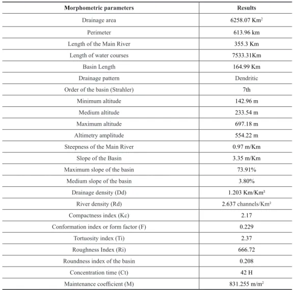
Table 1 describes the morphometric results obtained for the Coco River Basin.
Table 1 - Results of morphometric parameters of the Coco River Basin
Morphometric parameters Results
Drainage area 6258.07 Km2
Perimeter 613.96 km
Length of the Main River 355.3 Km
Length of water courses 7533.31Km
Basin Length 164.99 Km
Drainage pattern Dendritic
Order of the basin (Strahler) 7th
Minimum altitude 142.96 m
Medium altitude 233.54 m
Maximum altitude 697.18 m
Altimetry amplitude 554.22 m
Steepness of the Main River 0.97 m/Km
Slope of the Basin 3.35 m/Km
Maximum slope of the basin 73.91%
Medium slope of the basin 3.80%
Drainage density (Dd) 1.203 Km/Km²
River density (Rd) 2.637 channels/Km²
Compactness index (Kc) 2.17
Conformation index or form factor (F) 0.229
Tortuosity index (Ti) 2.37
Roughness Index (Ri) 666.72
Roundness index of the basin 0.208
Concentration time (Ct) 42 H
Maintenance coeicient (M) 831.255 m/m2
The basin of the Coco River is classiied as 7th order, according to Strahler classiication (1952). This has an area of 6,670 Km ², but the considered area for analysis was 6258.07 Km², since the area that make up the seasonally looded plains (lakes region) was not considered for analysis.
The observed drainage density was 1.203 Km / Km², indicating that the basin has a medium drainage capacity. Regarding the drainage density, the value found was 2,637 channels / Km², i.e., each square kilometer there are 2,637 channels, however, it is noted that the basin has a variable
87 The observed values of the compactness index (2.17), form factor (0.229) and roundness index
(0.208) indicate that the Coco River Basin doesn’t have a circular shape, corresponding, therefore,
to an elongated basin feature, being, little susceptible to looding under normal precipitation
condi-tions. Besides these characteristics, the concentration time found was considered high (42 hours),
increasing the low probability of looding.
The sinuosity observed to the Coco River was 2.37, according to Stipp et al. (2010, p. 122),
above 2.0 sinuosity values is characteristic of a sinuous drainage network, with possible accumu -lation of sediments along the channel, which can be aggravated by human action.
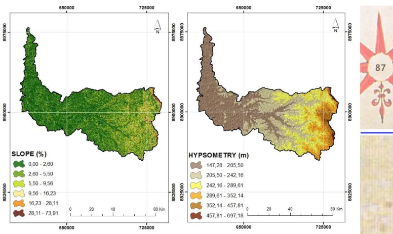
The average slope of the basin was 3.8%, indicating the predominance of a lat relief to gently undulating and a maximum of 73.91% (Figure 1), near Estrondo Ridge (basin hydrographic basin), strongly wavy relief, as the EMBRAPA classiication (1979). It should be mentioned that the Coco River Basin is very extensive, which has a heterogeneous relief in all its extension, which reinforces
the importance of compartmentalization of it, in order to further analysis.
A minimum altitude of 142.96 m and a maximum of 697.18 m (Figure 1) was observed,
re-sulting in an altimetry amplitude of 554.22 m. This has a direct relationship with the roughness of
the basin, which was considered strong (Ri = 666.72).
Figure 1 - Hypsometry and slope of the Coco River Basin.
MORPHOMETRIC COMPARTMENTALIZATION OF THE COCO RIVER BASIN
88 Figure 2 - Morphometric compartmentalization of the Coco River Basin.
The morphometric compartmentalization of the Coco River Basin enabled the identiication
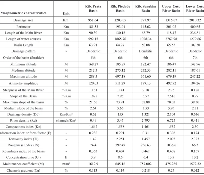
of distinctive features throughout the basin. Table 2 shows the results obtained for morphometric parameters assessed in the compartments.
The evaluated sub-basins have a drain dendrite pattern with diversiied drainage density values. According to Villela and Mattos (1975, p. 245), the drainage density (Dd) may vary from 0.5 km / km² for basins with little drainage to values above 3.5 km / km² for exceptionally well-drained basins. In this context, evaluated sub-basins can be grouped, as its drainage, in the following way: a) well-drained - basin of the Upper Coco River (2.104 km / km²); b) average drainage - sub--basins of Ribeirão Piedade (1.55 km / km²) and Ribeirão Surubim (1.321 km / km²) and c) poor drainage - Ribeirao Prata sub-basins (0.62 km / km²) and Lower Coco River (0.636 km / km²).
The water density relates the number of channels with the total area of the basin (Almeida et al., 2013, p. 139), or indicates the number of channels to each square kilometer. As can be seen
in Table 02the values vary considerably between the analyzed compartments, deserving highlight
the basin of the Upper Coco River with 6.725 channels / km ², and the Lower Coco River sub--basins with 0.411 channels / km² and Ribeirão Prata with 0.49 channels / km², indicating that the sub-basin of the Upper Coco River has a greater capacity to generate new channels in relation to the other evaluated sub-basins which may be related to their pedologic, geological and climatic
characteristics. These results agree with the values obtained for the drainage density, by pointing
high iniltration to the sub-basins of the Lower Coco River and Ribeirão Prata and high surface runof for sub-basin of the Upper Coco River.
89
et al. (2006, p. 244), in the basins with circular shape there are greater possibilities of heavy rains
occur simultaneously in all its extension, concentrating large volume of water in the main tributary. Table 2 - Results of morphometric parameters of the compartments of the Coco River Basin
Morphometric characteristics Unit
Rib. Prata Basin
Rib. Piedade Basin
Rib. Surubim Basin
Upper Coco River Basin
Lower Coco River Basin
Drainage area Km² 951.64 1203.05 777.97 1315.07 2010.32
Perimeter Km 181.53 193.01 145.62 201.02 400.65
Length of the Main River Km 90.30 130.18 68.79 118.47 236.81
Length of water courses Km 592.15 1865.76 1028.34 2767.98 1279.66
Basin Length Km 63.91 64.27 50.08 65.55 107.30
Drainage pattern - Dendritic Dendritic Dendritic Dendritic Dendritic
Order of the basin (Strahler) 5th 6th 6th 6th 7th
Minimum altitude M 168.27 185.89 182.47 186.47 142.96
Medium altitude M 212.3 275.12 232.53 282.11 187.61
Maximum altitude M 288.3 697.18 361.60 679.19 247.22
Altimetry amplitude M 120.03 511.29 179.13 492.72 104.26
Steepness of the Main River m/Km 1.131 1.141 2.18 2.75 0.128
Slope of the Basin m/Km 1.878 7.95 3.57 7.516 0.97
Maximum slope of the basin % 21.56 73.91 32.88 70.03 39.30
Medium slope of the basin % 2.64 5.66 3.53 5.95 2.31
Drainage density (Dd) Km/Km² 0.62 155 1.321 2.104 0.636
River density (Rd) channels/Km² 0.49 3.47 2.795 6.725 0.411
Compactness index (Kc) - 1.647 1.558 1.461 1.552 2.50
Conformation index or form factor (F) - 0.232 0.291 0.31 0.306 0.174
Tortuosity index (Ti) - 1.42 2.251 1.457 2.095 2.323
Roughness Index (Ri) - 74.4 792.49 236.63 1036.6 66.3
Roundness index of the basin - 0.363 0.404 0.461 0.408 0.157
Concentration time (Ct) H 3.9 8.6 6.4 13.7 10.2
Maintenance coeicient (M) m/m² 1612.9 645.16 757.002 475.285 1572.32
Channels gradient (Cg) % 0.113 0.114 0.218 0.27 0.012
As regards to the concentration time, i.e., the time required for all the fallen precipitation at any point of the basin reaches its end point, was observed for Upper and Lower Coco River sub-basin the highest values, being 13.7 for the irst and 10.2 to the second. The sub-basin that presented a shorter concentration was Ribeirão Prata sub-basin (3.9) and the Ribeirão Piedade sub-basins a
value of 8.6 and Ribeirão Surubim 6.4.
90
Sousa and Rodrigues (2012, p. 142) points out that high roughness values indicate severe runof
and also erosive events.
In terms of medium slope, the values range from 2.31% to 5.95% representing a lat relief to gently undulating, as the EMBRAPA classiication (1979), however, it is noteworthy that the pre-sence of a strongly wavy relief was also identiied, with maximum slope of up to 73.91%, deserving highlight the sub-basins of the Upper Coco River and Ribeirão Piedade, which showed the highest values for both the medium slopes as to the maximum. For these sub-basins, there is a tendency of increased runof compared to the others, under the same conditions of vegetation cover, soil type
and precipitation, suggesting a higher natural fragility and hence more prone to degradation.
For the medium slope of the main channel and gradient channels, stood out the sub-basins of the Upper Coco River and Ribeirão Surubim, observing respective slope values of 2.75 m/m and 2.18 m/km. Tonello et al. (2006, p. 855) report that the channel slope interfere in the low velocity of the water on the course, thus, high values indicate greater runofs and shorter time of permanence
of water, being convenient a more intensive soil and water management.
According to Santos and Morais (2012, p. 626), the maintenance factor is an index that aims to calculate the minimum area which the basin must provide for the maintenance of a luvial channel meter, being its result indicated in m/m². In the analysis were highlighted the sub-basins of Ribeirao Prata and Lower Coco River with the highest values for this coeicient, being found 1612.9 m/m² for the irst and 1572.32 m/m² for the second. As can be seen the mentioned sub-basins require a
considerable area for maintenance (recharge area) and evolution of drainage. These results can be corroborated by the drainage density and hydrographic, which it was the lowest recorded, suggesting
that the sub-basins have diiculties in renewing and training of new channels. This reality can be understood when it is found that the sub-basins presented low medium declivity, being considered its relief lat to gently undulating, as the EMBRAPA classiication (1979), and low roughness in-dexes, very important factors in the river low and formation of new channels. Table 3 shows the
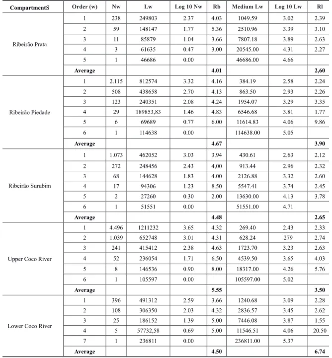
results obtained for the Horton’s laws (1945).
The medium value for the bifurcation rate (Rb) for the analyzed sub-basins was similar, ha-ving the Upper Coco River sub-basin a greater observed value (5.55). Vestena et al. (2011, p. 99)
studying the morphometry of the Caeté River Basin they found a medium value for the bifurcation
rate close to that found for the Coco River sub-basins (4.0). The value 2.00 is normally found, however, if the channels produce certain slope, it can vary (HORTON, 1945, p. 291). According
to Castro and Carvalho (2009, p. 04), the bifurcation ratio (Rb) indicates the degree of dissection
of the river basin, the higher the value of the bifurcation index, greater the degree of dissection,
values generally under 2 indicate hilly relief, therefore, the results suggest the presence of a relief
dissected for the analyzed sub-basins.
It is mentioned that the values of bifurcation ratio (Rb) for the segments of the evaluated sub--basins do not have a speciic pattern. You can see that the Ribeirão Prata sub-basin showed a higher Rb between the channels of irst and second order (5.36), indicating for this compartment that the lower the hierarchical order, the greater the bifurcation ratio. In the case of sub-basins of Ribeirões Piedade and Surubim the largest veriied bifurcation ratios were between the channels of fourth and ifth order, having the channels of irst to third orders similar bifurcation behaviors. As for the sub-basins of the Upper Coco River and Lower Coco River the most representative bifurcation rate was for ifth-order channels, having the Upper Coco River a greater number of channels of lower orders (1st and 2nd). Was also found that the said sub-basin has forming channels of inner basins (microbasins), considering the number of identiied channels of superior orders (4th and 5th orders).
For the ratio between the medium lengths of the channels (Rl), stood out the sub-basin of the Lower Coco River with a medium value of 6.74 and the sub-basin of Ribeirão Piedade with 3.90. Already Ribeirao Prata sub-basins, Ribeirão Surubim and Upper Coco River showed similar
91 Table 3 - Application results of Horton laws to the compartments of the Coco River Basin
Compartments Order (w) Nw Lw Log 10 Nw Rb Medium Lw Log 10 Lw Rl
Ribeirão Prata
1 238 249803 2.37 4.03 1049.59 3.02 2.39
2 59 148147 1.77 5.36 2510.96 3.39 3.10
3 11 85879 1.04 3.66 7807.18 3.89 2.63
4 3 61635 0.47 3.00 20545.00 4.31 2.27
5 1 46686 0.00 46686.00 4.66
Average 4.01 2,60
Ribeirão Piedade
1 2.115 812574 3.32 4.16 384.19 2.58 2.24
2 508 438658 2.70 4.13 863.50 2.93 2.26
3 123 240351 2.08 4.24 1954.07 3.29 3.35
4 29 189853,83 1.46 4.83 6546.68 3.81 1.77
5 6 69689 0.77 6.00 11614.83 4.06 9.86
6 1 114638 0.00 114638.00 5.05
Average 4.67 3.90
Ribeirão Surubim
1 1.073 462052 3.03 3.94 430.61 2.63 2.12
2 272 248456 2.43 4,00 913.44 2.96 2.32
3 68 144628 1.83 4.00 2126.88 3.32 2.60
4 17 94306 1.23 8.50 5547.41 3.74 2.45
5 2 27260 0.30 2.00 13630.00 4.13 3.78
6 1 51551 0.00 51551.00 4.71
Average 4.48 2.65
Upper Coco River
1 4.496 1211232 3.65 4.32 269.40 2.43 2.33
2 1.039 652748 3.01 4.31 628.24 279 2.74
3 241 415412 2.38 4.63 1723.70 3.23 2.63
4 52 236054 1.71 6.50 4539.50 3.65 4.03
5 8 146536 0.90 8.00 18317.00 4.26 5.76
6 1 105597 0.00 105597.00 5.02
Average 5.55 3.50
Lower Coco River
1 396 491312 2.59 3.66 1240.68 3.09 2.28
2 108 306350 2.03 4.32 2836.57 3.45 2.62
3 25 186152 1.39 5.00 7446.08 3.87 1.55
4 5 57732,58 0.69 5.00 11546.51 4.06 20.50
7 1 236811 0.00 236811.00 5.37
Average 4.50 6.74
NOTE: Nw is the number of channels; Rb is the bifurcation rate; Lw is the medium length; Rl is the rate of length.
The results of morphometric analysis in the diferent compartments of the Coco River Basin indicated that the sub-basins of the Upper Coco River and Ribeirão Piedade are the compartments
that have higher natural fragilities. Therefore, these compartments deserve special attention as regards the activities of use and occupation of the soil, which, if not performed with caution may
potentiate the efects of natural processes, such as the intensiication of soil losses by erosion and
92
FINAL CONSIDERATIONS
From the results obtained for morphometric compartmentalization of the Hydrographic Basin
of Coco River can be concluded that:
• The analysis of compactness indices, roundness and form factor indicated that all evaluated compartments exhibited elongated shape, signaling little susceptibility to loods in regular
rainfall conditions;
• The sub-basins of Ribeirão Prata and Lower Coco River are compartments that showed the highest maintenance coeicients, 1612.9 m/m² and 1572.32 m/m² respectively, indicating a
considerable area for maintenance (recharge area) and evolution of drainage;
• The sub-basin of the Upper Coco River presented a greater number of lower orders channels
(1st and 2nd), and indicate high ability to articulate forming channels of inner basins (micro
-basins), given the number of identiied channels of superior orders (4th and 5th orders); • The more representative density and hydrographical drainage was for the sub-basin of the Upper Coco River with 2.104 Km/Km² and 6.725 channels/Km², respectively, indicating gre-ater ability to generate new channels in relation to the other evaluated sub-basins which can
be related to their soil, geological and climatic characteristics;
• Roughness presented to the sub-basin of the Upper Coco River (Ri = 1036.60) and the sub-basin of Ribeirão Piedade (Ri = 792.49) suggest severe runof and also the erosive
occurrences for these compartments, implying conservation soil practices.
Therefore, the set of analyzed morphometric parameters indicated that the sub-basins of the Upper Coco River and Ribeirão Piedade are the compartments that have higher natural fragilities,
requiring greater management of the activities of use and occupation of the soil, to minimize the
potential efects of natural processes occurring in these compartments.
BIBLIOGRAPHIC REFERENCE
ALMEIDA, Wagner Santos; SOUZA, Newton Moreira; REIS JÚNIOR, Dirceu Silveira; CARVALHO, José Camapum. Análise morfométrica em bacias hidrográicas luviais como indicadores de processos erosivos e aporte de sedimentos no entorno do reservatório da Usina Hidrelétrica (UHE) Corumbá IV. Revista Bra-sileira de Geomorfologia, v.14, n.2, (Abr-Jun), 2013. p. 139.
ARAÚJO, Eliene Pontes; TELES, Mércia Gabriely Linhares; LAGO, Willinielsen Jackieline Santos. Deli-mitação das bacias hidrográicas da Ilha do Maranhão a partir de dados SRTM. In: XIV Simpósio Brasileiro de Sensoriamento Remoto. Anais... Natal, Brasil, 2009, INPE, p. 4631.
BARBOSA, Tamires Silva; FURRIER, Max. Avaliação Morfológica e Morfométrica da Bacia Hidrográi-ca do Rio Marés – PB, Para VeriiHidrográi-cação de Inluência NeotectôniHidrográi-ca. Cadernos de Geociências, v. 9, n. 2, novembro 2012. p. 112.
93
EMPRESA BRASILEIRA DE PESQUISA AGROPECUÁRIA – EMBRAPA. Serviço Nacional de Levan-tamento e Conservação de Solos (Rio de Janeiro, RJ). Súmula da 10. reunião Técnica de Levantamento de Solos. Rio de Janeiro, 1979. 83p.
FREIRE, Aline Jardim; LAGE, Gustavo Bretas; CHRISTÓFARO, Lage Cristiano. Comparação entre parâ-metros morfométricos de bacias hidrográicas gerados por dados SRTM e ASTER GDEM: estudo de caso para bacias do Vale do Jequitinhonha-MG. In: XVI Simpósio Brasileiro de Sensoriamento Remoto – SBSR. Anais... Foz do Iguaçu (PR), Brasil, 2013. p. 5443.
GHEZZI, Alessandra Oliveira. Avaliação e mapeamento da fragilidade ambiental da Bacia do Rio Xaxim, Baía de Antonina – PR, com o auxílio de geoprocessamento. Dissertação (Mestrado em Ciência do Solo) - Departamento de Solos e Engenharia Agrícola/Universidade Federal do Paraná. Curitiba, 2003. 02 e 08 p. HORTON, R. E. Erosional development of streams and their drainage basins: hidrophysical approach to quantitative morphology. Geological Society of América Bulletin, v. 56, 1945. p. 807 – 813.
LANA, Cláudio Eduardo; ALVES, Júlia Maria de Paula; CASTRO, Paulo de Tarso Amorim. Análise mor-fométrica da bacia do Rio do Tanque, MG – Brasil. Rem: Rev. Esc. Minas, v. 54, n. 02, Ouro Preto (MG), Apr./June, 2001. p. 07.
NUNES, F. G.; RIBEIRO, N. C; FIORI, A. P. Propriedades Morfométricas e Aspectos Físicos da Bacia Hidrográica do Rio Atuba: Curitiba - Paraná. In: VI Simpósio Nacional de Geomorfologia/Regional Con-ference on Geomorphology. Anais... Goiânia (GO), setembro de 2006. p. 01.
RODRIGUES, Flávia Mazzer; PISSARRA, Teresa Cristina Tarlé; CAMPUS, Sérgio. Caracterização mor-fométrica da microbacia hidrográica do córrego da Fazenda Glória, Município de Taquaritinga, SP. Irriga, Botucatu, v. 13, n. 3, jul – set, 2008. p. 311.
SALLES, Moacir Mello. O uso do SIG na análise morfométrica da bacia hidrográica do Rio São João
(MG). Monograia (Especialização em Geoprocessamento) - Instituto de Geociências. Universidade Federal de Minas Gerais (UFMG). Belo Horizonte (MG), 2010. 05 p.
SANTOS, Daniel Araujo Ramos; MORAIS, Fernando. Análise morfométrica da bacia hidrográica do Rio Lago Verde como subsídio à compartimentação do relevo da região de Lagoa da Confusão – TO. Revista Geonorte, Edição Especial, v. 3, n. 4, 2012. p. 626.
SOARES, Márcia Regina Gomes de Jesus; SOUZA, Jorge Luiz Moretti. Análise morfométrica da Bacia Hidrográica do Rio Pequeno em São José dos Pinhais (PR). Revista Geograia (Londrina), v. 21, n. 1, jan/ abr. 2012. p. 20.
SOUZA, Celia Regina de Gouveia. Suscetibilidade morfométrica de bacias de drenagem ao desenvolvimento de inundações em áreas costeiras. Revista Brasileira de Geomorfologia, Ano 6, n. 1, 2005. p. 52.
SOUSA, Flávio Alves; RODRIGUES, Sílvio Carlos. Aspectos morfométricos como subsídio ao estudo da condutividade hidráulica e suscetibilidade erosiva dos solos. Mercator - Revista de Geograia da UFC, v. 11, n. 25, mai-ago, 2012. p. 142.
STIPP, Nilza Aparecida Freres; CAMPOS, Ricardo Aparecido; CAVIGLIONE, João Henrique. Análise mor-fométrica da Bacia Hidrográica do Rio Taquara – uma contribuição para o estudo das ciências ambientais.
Portal da Cartograia, Londrina v. 3 n. 1, 2010. p. 122.
STRAHLER, A. N. Hypsometric (area-altitude) analysis and erosional topography. Geological Society of America Bulletin, v. 63, 1952. p. 1117 – 1142.
TONELLO, Kelly Cristina; DIAS, Herly Carlos Teixeira; SOUZA, Agostinho Lopes de; RIBEIRO, Carlos Antonio Alvares Soares Ribeiro; LEITE, Fernando Palha. Morfometria da Bacia Hidrográica da Cachoeira das Pombas Guanhães (MG). Revista Árvore, Viçosa-MG, v. 30, n.5, 2006. p. 855.
TEODORO, Valter Luiz Iost; TEIXEIRA, Denilson; COSTA, Daniel Jadyr Leite; FULLER, Beatriz Buda. O conceito de bacia hidrográica e a importância da caracterização morfométrica para o entendimento da dinâmica ambiental local. Revista Uniara, n. 20, 2007. p. 137.
94
VILLELA, S. M.; MATTOS, A. Hidrologia aplicada. São Paulo: McGraw-Hill do Brasil, 1975. 245p.
Submitted 6 september 2016