In this paper we focus on the structure and territorial borders of the Baltic Sea re-gion, and examine the key structural ele-ments of the transnational territorial trans-port system. In this respect, we clarify some terms used in transport geography. For the first time the transport system gets territo-rially localized, which allows for a broad range of new studies of transnational transportation in the Baltic Sea area. We also identify the main principles of devel-opment and operation of international ter-ritorial transport systems and present them taking the Baltic Sea region as an example. Our findings, we hope, will have a great practical application for researchers of transport geography, especially those studying international logistics.
Key words: Baltic Sea area; regional, transnational and international territorial transport system
The existence of the complex trans-national Baltic region is an established fact (despite the ongoing debates trying to establish its borders, structure and perspectives), while the only trace of the corresponding transport system around the Baltic Sea is the distant echo of the so-called ‘Baltic Ring’, an international project of the 1990s-2000s. The Baltic Sea itself, however, has served as an im-portant link between the coastal areas ever since the times of the Vikings — it has been establishing necessary connec-tions between the land-based transport hubs, from which the goods and people continued on to the heart of Europe. In the 20th century the automobile roads and railways encircled the Baltic Sea, and the unity of the emerging transna-tional Baltic transport system was only growing stronger. The political proc-esses that started in the 1980s and con-tinued for more than two consecutive decades — the reunification of Ger-many, the fall of the Soviet empire, EU THE TRANSNATIONAL
TERRITORIAL TRANSPORT
SYSTEM OF THE BALTIC
REGION
I. S. Gumenyuk
D. A. Melnik*
* Immanuel Kant Baltic Federal University
14 Nevskogo str., Kaliningrad 236041, Russia
Received 11 November 2011
Baltic expansion, development of cooperation between the Russian Federa-tion and the European Union — helped tighten the already existing links.
In 1992, with the establishment of the Council of the Baltic Sea States and its target-oriented working groups, with the arrival of strategic docu-ments on spatial planning of the Baltic Sea territory (VASAB1), more and more Russian and Western researchers started using the new buzz phrase — the Baltic region — in their discussions of the hatching international trans-port system.
In this article we try to understand whether we actually can talk about a real transnational territorial transport system developing around the Baltic Sea or maybe we should view it as a combination of national (regional) transport systems that performs certain functions within the Baltic region. And if we really deal with the unified system, then what are its spatial di-mensions, what are its key structural elements and special features? And do the ‘transnational Baltic transport region’ and the ‘complex Baltic region’ have the same geographical limits?
Before we attempt to answer those questions, we need to establish the meaning of an ‘international transport system’ (transnational, which includes the territories of many different countries, or cross-border, which includes geographical and municipal units of 2—3 adjacent states). What is the struc-ture of this system and what is its place in the hierarchy of transport systems?
The notion of ‘territorial transport system’ emerged in the sphere of ge-ography and was used to describe geographical dimension of the study of transport systems. Transport system is a natural subject of research for many disciplines (in science, social science and humanities), however a geographer will first look at the spatial dimension of the system, its interaction with the environment, agriculture, local population, industry and other territorial characteristics. As S.A. Tarkhov and I.A. Syomina aptly put it, “geography studies transport in the context of the territory, as for us it is indivisible from environmental, social and economic surroundings» [2].
Traditionally ‘territorial transport system’ is understood as a complex (or one) of transportation types united into a system in a limited social and eco-nomic space. In this space, there happens an active interaction of various types of transportation, each complimenting the other and, at the same time, competing with the other for the destinations, hinterlands and certain trans-portation lines. A territorial transport system is different from a transport system by way of establishing this relation between transportation and the geography of a region [3].
Both Russian and international scholars often use the terms ‘territorial transport systems’ (TTS) and ‘regional transport systems’ (RTS) inter-changeably. In our view, this is not entirely accurate, since the two phenom-ena, while being related, do have their own special features. The main differ-ence is that TTS are identified through the analysis of transport hubs and their connectivity, while an RTS is a functional integral part of a region, and
1
it is identified through the analysis of a number of social, economic and geo-graphical dimensions (where transport is one of the important, but not the most important, components). The connectivity of a TTS as a transportation-industrial system is higher than that of an RTS, and the spatial borders of TTS and RTS can both coincide and differ in the same region.
For the purpose of this article we will understand TTS as an intercon-nected combination of transportation hubs, lines and equipment for transfer-ring goods and people.
International territorial transport systems (ITTS) are interconnected transport systems of adjacent states (transnational systems) and/or certain regions within those states (cross-border systems). We here assume that an ‘international territorial transport system’ and ‘international transport re-gion/area’ are fundamentally the same and can be used as synonyms. Eco-nomic zoning (identification of ITTS) in the sphere of international logistics helps to identify positive prerequisites for the development of cross-border cooperation, as well as ‘bottlenecks’ and problems hindering communication between the neighbouring states.
Coming back to the Baltic Sea region, it is safe to assert that the borders of the RTS here coincide with the borders of the region itself (the geography of the region is well theorized in the works of Kaliningrad researchers from IKBFU and some other scholars [4—6]), and encompass Denmark, Sweden, Finland, Baltic Sea states, Schleswig-Holstein, Mecklenburg-Western Pom-erania (both German areas), a number of Polish administrative units (West Pomeranian, Pomeranian and Warmia-Masury Voivodeships), and St. Pe-tersburg, Leningrad, Pskov, Novgorod and Kaliningrad regions of Russia. To establish the borders of the transnational TTS of the Baltic region we first must look at its structural elements.
Sea transport forms the basis of the TTS of the region. It plays a crucial role in the entire system because it allows East-bound (Russia, Kazakhstan, Asian and Pacific regions) and West-bound (EU and North America) trans-fer of cargo.
Railways, roads and internal water ways within the Baltic transport sys-tem function as connectors, ensuring the free movement of people and cargo from big transportation hubs to destinations of consumption/production or settlement (including the destinations around the Baltic Sea). They also fa-cilitate transit of hinterlands of the sea ports located along the Baltic Sea coast. The main transport corridors here are European motorways and rail-way systems encompassing the Baltic Sea region [7].
Air transportation has a potential of becoming a key structural unit within the TTS, a situation that is prompted by the growing demand for transportation of people. The Baltic Sea region is experiencing the develop-ment of several major airhubs (airports) that compete for the central posi-tions in both European and global passenger transfer (Copenhagen, Riga, Hamburg, Helsinki, Warsaw, St. Petersburg).
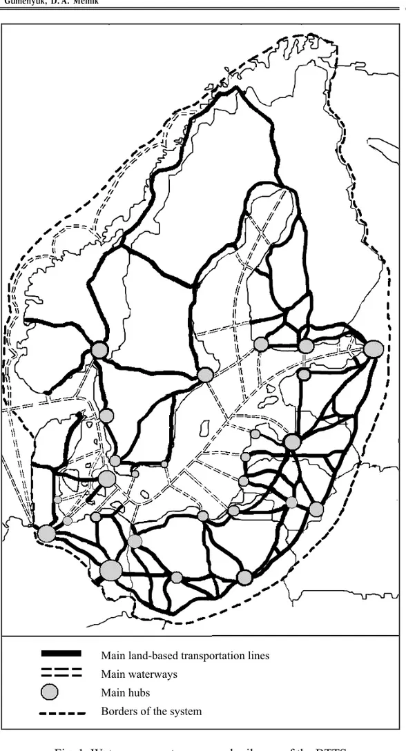
Fig. 1. Waterways, motorways and railways of the BTTS
Main land-based transportation lines
Main waterways
Main hubs
From the map we can see that the actual borders of the Baltic TTS (BTTS) are slightly different from the ones that were previously theorized by the researchers and adopted by the VASAB. Following the delineations of VASAB, but contrary to the works of Kaliningrad scholars, we include all of Norway, Hamburg, Brandenburg, central part of Poland and Grodno (Bela-rus) into the BTTS. Unlike VASAB, however, we exclude the south of Po-land and most of Belarus from this network.
Following the propositions put forward by the VASAB programme, the European Union is creating a research-based transportation system that would go through most of the territories of the EU with the access to the Baltic Sea. Norway also coordinates its transport development policy with the EU. Taking into account the geographical location of the Russian and Belorussian Baltic territories and with the understanding that efficient functioning of the transport system of those regions is only possible in close cooperation with the transport systems of other countries, it is only logical to include those areas into the united Baltic TTS. However, Russian and Belorussian federal subjects that are linked to the BTTS do not fully coordinate their transport policies with the development strategy of the EU. The lack of common rules and norms in transportation, and the lack of a coordinated policy of strategic spatial planning, as well as underdeveloped measures of overseeing and control of the regional transportation do not allow us to confirm the full integration of Russian and Belorussian regions into the BTTS.
Apart from the challenges that are shared between the regions, there are also barriers that are very region-specific, and those are the roadblocks on the way to the full integration into the Baltic transport system. To identify those roadblocks and propose concrete steps on how to remove them should be one of the key assignments for researchers of transport geography in Rus-sia, in the European Union, and in the Kaliningrad region.
References
1. VASAB. available at: http://www. vasab. org (accessed 6 Oktober 2011). 2. Tarhov, S. A., Semina, I. A. 2009, Geografija transporta kak otraslevaja geograficheskaja nauka [Geography of Transport as a branch geographical science], Aktual'nye problemy geografii i geojekologii, no. 1 (5), available at: http://geoeko. mrsu. ru/2009—1/pdf/12_Tarhov. pdf (accessed 6 Oktober 2011).
3. Tarhov, S. A., Shlihter, S. B. 1995, Geografija transportnyh sistem. Kurs lekcij [The geography of transport systems. A course of lectures], Moscow, ROU; IG RAN.
4. Fedorov, G. M., Zverev, Ju. M. and Korneevets, V. S. 1997, Rossijskij jeksk-lav na Baltike [The Russian exclave on the Baltic Sea], Kaliningrad, Izd-vo Kalin-ingr. un-ta, 312 p.
5. Fedorov, G. M., Korneevets, V. S. 1999, Baltijskij region [The Baltic Re-gion], Kaliningrad, Izd-vo Kaliningr. un-ta, 208 p.
6. Mezhevich, N. M. Baltijskij region i Rossija na Baltike: specifika pozicioni-rovanija [The Baltic Region and Russia on the Baltic Sea: the specificity of position-ing], Tartu Ülikool, available at: http://www. ut. ee/ABVKeskus/sisu/ pub-likatsioonid/2004/pdf/VF-B. pdf (accessed 15 January 2009).
8. Towards an integrated Baltic Sea Region: Cities and Regions as drivers for spatial development and integration, VASAB, available at: http://www. vasab. org/east-west-window/documents/WG1_report_final_version_part2_appendix. pdf (accessed 6 Oktober 2011).
About the authors
Dr Ivan S. Gumenyuk, lecturer, Department of Social and Economic Geography and Geopolitics, Immanuel Kant Baltic Federal University.
E-mail: IvaGum85@mail. ru
Dmitry A. Melnik, PhD student, Department of Social and Economic Geography and Geopolitics, Immanuel Kant Baltic Federal University.