The implementation of an Enterprise Geographical
Information System to support Cadastre and Expropriation
activities.
The case of Ferbritas Cadastre Information System.
The implementation of an Enterprise Geographical
Information System to support Cadastre and Expropriation
activities.
The case of Ferbritas Cadastre Information System.
ii
The implementation of an Enterprise Geographical
Information System to support Cadastre and
Expropriation activities.
The case of Ferbritas Cadastre Information System.
Project Report supervised by
Professor Doutor Marco Octávio Trindade Painho
iii
Credits
I would like to express my sincere gratitude towards my supervisor, Professor Doutor Marco Painho, for his comments, suggestions, support and guidance during the development of the thesis.
Sincere thanks to ProSistemas, SA which provided me the initial means to accomplish this Masters Course, and particularly on behalf of Eng. João Lopes da Fonseca for its formal support, personal interest and initial encouragement.
I would like to thank Ferbritas, SA on behalf of Eng. Luis Mata, for his formal support, leadership and vision that made possible FBSIC.
I would like to thank REFER Património, SA board for grant me the permissions needed to attend the last part of this Masters Course.
I would like to thank everyone who somehow supported and/or encouraged this work, particularly to Rui Roda, Nuno Leite, Rui Sabino, and all development team for their support and fellowship during all project.
iv
The implementation of an Enterprise Geographical
Information System to support Cadastre and
Expropriation activities.
The case of Ferbritas Cadastre Information System.
Abstract
The processes of mobilization of land for infrastructures of public and private domain are developed according to proper legal frameworks and systematically confronted with the impoverished national situation as regards the cadastral identification and regularization, which leads to big inefficiencies, sometimes with very negative impact to the overall effectiveness.
This project report describes Ferbritas Cadastre Information System (FBSIC) project and
tools, which in conjunction with other applications, allow managing the entire life-cycle of
Land Acquisition and Cadastre, including support to field activities with the integration of information collected in the field, the development of multi-criteria analysis information, monitoring all information in the exploration stage, and the automated generation of outputs. The benefits are evident at the level of operational efficiency, including tools that enable process integration and standardization of procedures, facilitate analysis and quality control and maximize performance in the acquisition, maintenance and management of registration information and expropriation (expropriation projects). Therefore, the implemented system achieves levels of robustness, comprehensiveness, openness, scalability and reliability suitable for a structural platform.
The resultant solution, FBSIC, is a fit-for-purpose cadastre information system rooted in the field of railway infrastructures.
v
The implementation of an Enterprise Geographical
Information System to support Cadastre and
Expropriation activities.
The case of Ferbritas Cadastre Information System.
Resumo
Os processos de mobilização de terrenos para infra-estruturas do domínio público e privado são desenvolvidos de acordo com quadros legais próprios e confrontam-se sistematicamente com uma situação nacional insuficiente no que se refere à identificação e regularização cadastral, o que acarreta penalizantes ineficiências, com impacte muito negativo para a eficiência e produtividade global.
Este relatório descreve o projecto e ferramentas do FBSIC que, em conjunto com outras aplicações, permitem gerir todo o ciclo de vida de Aquisição de Terra e Cadastro, incluindo suporte para actividades de campo com a integração de informações recolhidas, o desenvolvimento de análises de informação multicritério, acompanhamento de todas as informações na fase de exploração, e a geração automática de relatórios e mapas.
Os benefícios são patentes ao nível da eficiência operacional, com a inclusão de ferramentas que possibilitam a integração de processos e a normalização de procedimentos, facilitam a análise e controlo de qualidade e maximizam a performance na aquisição, manutenção e gestão de informação de cadastro e expropriações. Desta forma, o sistema implementado atinge níveis de robustez, abrangência, abertura, escalabilidade e fiabilidade adequados a uma plataforma estruturante.
A solução resultante, FBSIC, é um sistema de informação cadastral ajustado à finalidade para que foi desenvolvido enraizado na temática das infra-estruturas ferroviárias.
vi
Keywords
Ferbritas, Cadastre Information System, FBSIC, Land, Land Administration, Land Administration System, Land Information System, Land Management Paradigm, Land Administration Domain Model, LADM, Social Tenure Domain Model, STDM, Crowdsourcing, Cadastre, Expropriations, Railway Public Domain, Inspire Directive, Geographic Information Systems, GIS, Web Mapping, ArcGIS Server, Flex, .Net (C#), SOA, GIScience, CyberGIS, Information Integration, Project Management, CyberLand.
Palavras-chave
vii
Acronyms
BIM Building Information Modelling
CAD Computer Aided Design
CEO Chief Executive Officer CFO Chief Financial Officer
CI Cyberinfrastructure CIO Chief Information Officer
CORS Cross-Origin Resource Sharing
CPO Chief Project Officer
CyberGIS Cyberinfrastructure-based Geographic Information Systems
DBMS Database Management System
DGT Directorate General for Land
DMS Document Management System
DUP Public Use Declaration
EC European Commission
Esri Environmental Systems Research Institute
EU European Union
EuroGeographics European National Mapping, Cadastral and Land Registry Authorities Organization
EXP Expropriations Department
viii
FAO Food and Agriculture Organization of the United Nations
FB Ferbritas S. A.
FBSIC Ferbritas Cadastre Information System FGDC Federal Geographic Data Committee FIG International Federation of Surveyors
Gb Giga Byte
GDP Gross Domestic Product
GIO Geographic Information Officer GIS Geographic Information Systems
GIScience Geographic Information Systems Science GLTN Global Land Tool Network
GNSS Global Navigation Satellite System GPS Global Positioning System
GUI Graphical User Interface HRSI High resolution satellite imagery
ICT Information and Communication Technologies IGP Portuguese Geographic Institute
ILC International Land Coalition
INSPIRE Infrastructure for Spatial Information in the European Union ISSO International Organization for Standardization
IT Information Technologies
ix
LA Land Administration
LADM Land Administration Domain Model
LAN Local Area Network
LARSI Low altitude remotely sensed imagery LAS Land administration system
LCDM Legal Cadastral Domain Model
LGAF Land Governance Assessment Framework LINZ Land Information New Zealand
LIS Land Information System
MAOT Ministry for Environment and Spatial Planning
MAOTDR Ministry for Environment, Spatial Planning and Rural Development MFP Ministry for Public Finances
MIG Geographic Information Metadata Editor MPAT Ministry for Planning and Land Administration
MS Microsoft, Inc.
NIP Parcel Identification Number
NLIS National Land Information Systems
NMCA National Mapping and Cartography Agencies NRC National Research Council
PCC Permanent Committee on Cadastre in the European Union
PCM Ministries Council Presidency
x
PM Project Management
PMI Project Management Institute PPGIS Public Participation GIS PRJ Railway Projects Department R&D Research and Development
REFER Portuguese National Railway Infrastructure Manager
REFER DCC Portuguese National Railway Infrastructure Manager Construction and Coordination Department
REFER DPI Portuguese National Railway Infrastructure Manager Real Estate Department
REFER DSTI Portuguese National Railway Infrastructure Manager Information Technologies and Systems Department
RFP Request for Proposal
SAAS Software as a Service
SAM Spatial Analysis and Modelling SDI Spatial Data Infrastructure
SICE Expropriations and Cadastre Integrated System
SiNErGIC Cadastre Information Management and Development National System SNIG National System for Geographic Information
SOLA Solutions for Open Land Administration
SSADM Structured Systems Analysis and Design Method STDM Social Tenure Domain Model
TOP Survey Team
xi
UN United Nations
UNECE United Nations Economic Commission for Europe
UN-GGIM United Nations Initiative on Global Geospatial Information Management UN-HABITAT United Nations Human Settlements Programme
USD United States Dollar USN Ubiquitous Sensor Network
WAN Wide Area Network
Web ADF Web Application Developer Framework
WFS Web Feature Service
WMS Web Map Service
xii
Text Index
CREDITS ... III
ABSTRACT ... IV
RESUMO ... V
KEYWORDS ... VI
PALAVRAS-CHAVE ... VI
ACRONYMS ... VII
TEXT INDEX ... XII
TABLE INDEX ... XX
FIGURE INDEX ... XXI
1. INTRODUCTION ... 1
1.1. FRAMEWORK ... 1
1.1.1. WHY A CADASTRE INFORMATION SYSTEM? ... 1
1.1.2. FBSIC PLANNING STAGE ... 2
1.1.3. FBSIC IMPLEMENTATION STAGE ... 3
1.1.4. BENEFITS OF FBSIC PROJECT ... 4
1.2. OBJECTIVES ... 5
1.3. REPORT ORGANIZATION ... 5
1.4. MAIN PERSONAL CONTRIBUTIONS TO CADASTRE INFORMATION SYSTEM ... 5
1.4.1. MAIN ACTIVITIES AND RESPONSIBILITIES ... 5
2. LITERATURE REVIEW ... 7
2.1. LAND ADMINISTRATION ... 7
2.1.1. LAND ... 7
2.1.2. LAND ADMINISTRATION ... 9
2.1.3. LAND MANAGEMENT PARADIGM ... 13
xiii
2.1.4.1. Goals and Basic Features ... 14
2.1.4.2. Portugal Country Model ... 15
2.1.5. THE GLOBAL LAND TOOL NETWORK (GLTN) ... 16
2.1.6. SOCIAL TENURE DOMAIN MODEL (STDM) ... 17
2.1.7. SOLUTIONS FOR OPEN LAND ADMINISTRATION (SOLA) ... 18
2.1.8. CROWDSOURCING LAND ADMINISTRATION INFORMATION ... 18
2.2. CADASTRE ... 19
2.2.1. CADASTRE DEFINITION ... 19
2.2.1.1. Before 1995 FIG Statement ... 19
2.2.1.2. FIG Statement on the Cadastre ... 20
2.2.1.3. A wider inclusive view ... 20
2.2.2. CADASTRE AS THE ENGINE OF LAS ... 22
2.2.3. DELIVERING A SPATIALLY ENABLED LAS ... 23
2.2.4. THE BENEFITS OF A MODERN CADASTRE ... 25
2.2.5. CADASTRE IN THE WORLD.BRIEF STATUS. ... 27
2.2.6. CADASTRE IN EUROPE. ... 30
2.2.7. CADASTRE IN DEVELOPING COUNTRIES ... 32
2.2.8. CADASTRE IN PORTUGAL. ... 34
2.2.8.1. Brief overview. ... 34
2.2.8.2. Portuguese cadastre legislation references ... 35
2.3. THE INSPIRE DIRECTIVE ... 35
2.3.1. OVERVIEW ... 35
2.3.2. CADASTRAL PARCELS DATA THEME ... 38
2.4. GEOGRAPHIC INFORMATION SYSTEMS (GIS) ... 40
2.4.1. INTRODUCTION ... 40
2.4.2. GIS FROM THE EARLY DAYS TILL TODAY ... 40
2.4.3. GIS DEFINITION ... 42
2.4.4. GISCIENCE ... 43
xiv
2.5. CADASTRE,GIS,GEOSPATIAL INFORMATION INTEGRATION AND RAILWAYS. ... 44
2.5.1. CADASTRE,GIS AND GEOSPATIAL INFORMATION INTEGRATION ... 44
2.5.2. CADASTRE AND RAILWAYS ... 45
2.5.3. GIS AND RAILWAYS ... 47
2.6. INSTITUTIONAL ISSUES ... 48
2.7. FUTURE DEVELOPMENTS ... 49
3. METHODOLOGY ... 51
3.1. INTRODUCTION ... 51
3.2. BASE METHODOLOGIES ... 53
3.2.1. INTRODUCTION. ... 53
3.2.2. FBSIC SOFTWARE DEVELOPMENTS MODELS.BRIEF REVIEW. ... 53
3.2.2.1. Prototype development model ... 53
3.2.2.2. Waterfall development model ... 53
3.2.3. PROJECT MANAGEMENT ... 54
3.2.3.1. Introduction ... 54
3.2.3.1.1. Overall Development Processes ... 55
3.2.3.1.2. Overall Production Processes ... 56
3.2.3.2. Change Control System ... 57
3.2.3.3. Communication Plan ... 57
3.2.3.4. Final notes ... 57
3.3. PRELIMINARY STAGE ... 58
3.3.1. INTRODUCTION ... 58
3.3.2. THE GIS TEAM MISSION ... 59
3.3.3. INITIATING PROCESS. ... 59
3.3.3.1. Project Scoping ... 60
3.3.3.2. Initial Project Scoping Meetings ... 60
3.3.3.3. Approaches to Gathering Initial Requirements ... 60
3.3.3.4. Gaining Approval to Plan the Project ... 62
xv
3.3.4.1. Procurement Management Life Cycle ... 63
3.3.4.1.1. Contractor Solicitation ... 63
3.3.4.1.2. Contractor Evaluation ... 64
3.3.4.1.3. Contractor Selection ... 64
3.3.4.1.4. Gaining Approval to Launch the Project. ... 64
3.3.4.1.5. Contractor Contracting ... 65
3.3.4.1.6. Contractor Management ... 65
3.4. EXECUTING STAGE ... 65
3.4.1. INTRODUCTION ... 65
3.4.2. FBSIC PROJECT PHASE 1-FBSIC PROTOTYPE ... 66
3.4.2.1. Kick-off meeting ... 66
3.4.2.2. GIS Infrastructure (hardware and software) ... 66
3.4.2.3. Prototype Requirements ... 67
3.4.2.4. Prototype Software Analysis and Design ... 68
3.4.2.5. Prototype Developing ... 68
3.4.2.6. Prototype Acceptance Testing ... 68
3.4.2.7. Prototype Final deploy ... 68
3.4.2.8. FBSIC solution phase 2 requirements ... 68
3.4.2.9. Meetings ... 72
3.4.2.10. Closing ... 72
3.4.3. FBSIC PROJECT PHASE 2(FBSICWEB ADF) ... 73
3.4.3.1. Procurement procedures ... 73
3.4.3.2. Main features ... 74
3.4.3.3. Kick-off meeting ... 74
3.4.3.4. Software Analysis and Design ... 74
3.4.3.5. Developing ... 75
3.4.3.6. Global Acceptance Testing ... 75
3.4.3.7. Final deploy ... 76
xvi
3.4.3.9. Meetings ... 77
3.4.3.10. Closing ... 77
3.5. FBSICSOLUTION UPGRADING AND CORRECTIVE MAINTENANCES ... 77
3.5.1. INTRODUCTION ... 77
3.5.2. FBSIC SOLUTION UPGRADE AND CORRECTIVE MAINTENANCES MAIN FEATURES ... 78
3.5.2.1. FBSIC/FBX integration software developing services ... 78
3.5.2.2. REFER Domain Module and Final expropriation parcels drawings generation ... 79
3.5.2.3. 2011 FBSIC upgrading and corrective maintenance ... 79
3.5.2.4. GIS Infrastructure and FBSIC ArcGIS 10 (SP2) migration ... 79
3.5.2.5. FBSIC production support tools and procedures ... 80
3.5.2.6. 2012 FBSIC upgrading and corrective maintenance ... 81
3.6. OVERALL CLOSING OF FBSIC PROJECTS ... 81
4. RESULTS ... 81
4.1. INTRODUCTION ... 81
4.2. FBSIC V3.0.3 IMPLEMENTATION AND PRODUCTION PHASES ... 82
4.2.1. IMPLEMENTATION PHASE SOLUTION’S MAIN FEATURES ... 82
4.2.1.1. Introduction ... 82
4.2.1.2. FBSIC v3.0.3 Main features ... 83
4.2.1.2.1. FBSIC v3.0.3 Layers Diagram ... 83
4.2.1.2.2. FBSIC v3.0.3 Conceptual and Physical Architectures ... 84
4.2.1.3. FBSIC v3.0.3 modules ... 85
4.2.1.3.1. Data Migration Module ... 85
4.2.1.3.2. Field Module ... 85
4.2.1.3.3. Information Processing Module ... 86
4.2.1.3.4. Central Module ... 86
4.2.1.3.5. Approval Module ... 86
4.2.1.3.6. Domain Management Module ... 87
xvii
4.2.1.4. Technical documentation ... 87
4.2.2. PRODUCTION PHASE ... 87
4.3. PRESENTATIONS, POSTERS AND ARTICLE ... 89
4.4. AWARDS ... 89
5. CONCLUSIONS ... 90
5.1. SUMMARY ... 90
5.2. MAIN CONCLUSIONS ... 92
5.3. PRESENT LIMITATIONS ... 92
5.4. FUTURE WORKS ... 92
6. REFERENCES ... 94
ANNEXES ... 114
ANNEX 1 - SPATIALLY ENABLED GOVERNMENT AND SOCIETY ... 114
ANNEX 2 - CYBERLAND, TOWARDS AN UBIQUITOUS INTELLIGENT LAND ... 116
2.1 INTRODUCTION ... 116
2.2 UBIQUITOUS POSITIONING APPLIED TO CADASTRE ... 118
2.3 FINAL NOTES ... 120
ANNEX 3 - INITIAL REQUIREMENTS OVERVIEW ... 122
3.1 INTRODUCTION ... 122
3.2 CADASTRAL SURVEY AND EXPROPRIATIONS PROJECTS –GISPROJECTS DIAGNOSIS. ... 122
3.2.1 Railway Public Domain Macro Process ... 122
3.2.2 Defining priorities ... 123
3.2.3 Identification phase initial characterization ... 123
3.2.3.1 Sub-step 1.1: Cadastral survey preparation ... 123
3.2.3.2 Sub-step 1.2: Cadastral field survey ... 124
3.2.3.3 Step 2: Expropriations Project ... 125
ANNEX 4 - FBSIC PROJECT’S OVERVIEW ... 127
ANNEX 5 - FBSIC PROJECT PHASE 2 DIAGRAMS ... 132
5.1 INTRODUCTION ... 132
xviii
ANNEX 6 - FBSIC UPGRADING AND CORRECTIVE MAINTENANCES (2011-2012) ... 139
6.1 INTRODUCTION ... 139
6.2 FBSIC INTEGRATION WITH FERBRITAS ENTERPRISE SERVICE BUS (FBX) ... 139
6.3 REFER DOMAIN MODULE AND FINAL EXPROPRIATION PARCELS DRAWINGS GENERATION COMPONENT IMPLEMENTATION ... 139
6.4 2011FBSIC UPGRADING AND CORRECTIVE MAINTENANCE ... 140
6.5 FERBRITAS GISINFRASTRUCTURE AND FBSICARCGIS10(SP2) MIGRATION ... 141
6.5.1 Introduction ... 141
6.5.2 Esri components migration ... 141
6.5.3 GIS infrastructure applicational migration ... 141
6.5.4 Testing ... 142
6.5.5 Production GIS infrastructure upgrading ... 142
6.6 FBSICPRODUCTION SUPPORT TOOLS AND PROCEDURES ... 143
6.6.1 Introduction ... 143
6.6.2 Geographic database compress automatic daily procedure implementation (production): ... 143
6.6.3 Interface for process / service delivery creation development ... 143
6.6.4 Interface for map index information creation and loading ... 144
6.6.5 Interface for parcels grouping ... 144
6.6.6 Geographical and alphanumeric features linking automation ... 144
6.6.7 Cadastral parcels, Expropriation parcels and Entities delete feature availability (Central Module - Flex) ... 144
6.6.8 Geographic feature editing Flex availability ... 144
6.6.9 Central Module Flex migration, including multi language support structure .. ... 144
6.6.10 Expropriation parcels automatic numbering ... 144
6.7 2012FBSIC UPGRADING AND CORRECTIVE MAINTENANCE ... 144
6.7.1 Auditing and information quality check tool ... 145
xix
6.7.3 Quick reference map tip tool, including analysis, implementation, testing
and deployment of quick reference map tip pop-up. ... 146
6.7.4 Objects identification within project validation. ... 146
6.7.5 Global Improvements ... 146
6.7.6 Legend lateralization ... 146
ANNEX 7 - FBSIC V3.0.3 FUNCTIONALITIES MATRIX ... 147
7.1 INTRODUCTION ... 147
7.2 DATA MIGRATION MODULE ... 148
7.3 FIELD MODULE ... 149
7.4 INFORMATION PROCESSING MODULE ... 151
7.5 CENTRAL MODULE ... 153
7.6 APPROVAL MODULE ... 162
7.7 DOMAIN MANAGEMENT MODULE... 165
7.8 BACKOFFICE MODULE ... 168
7.9 SOLUTION DETAILED FUNCTIONALITIES ... 168
7.10 SOLUTION GLOBAL FEATURES ... 180
ANNEX 8 - FBSIC CENTRAL MODULE 2011 AND 2012 VERSIONS LOG ... 182
ANNEX 9 - FBSIC MAIN RESULTS COMPLEMENTS ... 186
9.1 MAIN PRESENTATIONS LIST ... 186
xx
Table Index
Table 1 - Land Registration & Cadastral Systems Worldwide (Williamson, et al., 2010) ... 27
Table 2 - Urban and rural areas, developed / developing countries vision (Lemmens, 2010) ... 32
Table 3 - FBSIC upgrade and corrective maintenance projects main dates. ... 78
Table 4 - FBSIC Production teams total and railway line work volume (July 27, 2013) ... 88
Table 4.1 - FBSIC projects and production stages main activities global overview……….. 131
Table 5.1 - FBSIC Phases Diagrams. Cadastral Survey Preparation (Ferbritas, 2010a)…. 133 Table 5.2 - FBSIC Phases Diagrams. Cadastral Survey (Ferbritas, 2010a) ... 134
Table 5.3 - FBSIC Phases Diagrams. Cadastral Survey Internal Validation (Ferbritas, 2010a) ... 135
Table 5.4 - FBSIC Phases Diagrams. Expropriations Project (Ferbritas, 2010a) ... 136
Table 5.5 - FBSIC Phases Diagrams. Expropriations Project Internal Validation (Ferbritas, 2010a) ... 137
Table 5.6 - FBSIC Phases Diagrams. REFER validation (Ferbritas, 2010a) ... 138
Table 7.1 - Data Migration Module main features………148
Table 7.2 - Field Module ... 150
Table 7.3 - Information Processing Module ... 152
Table 7.4 - Central Module ... 156
Table 7.5 - Approval Module ... 163
Table 7.6 - Domain Management Module ... 166
Table 7.7 - Backoffice Module ... 168
Table 7.8 - Tools listing and description... 174
Table 7.9 - Solution Global Features listing and description... 181
xxi
Figure Index
Figure 1 – Availability of site for construction (Gil & Mata, 2011c) ... 2
Figure 2 - Cadastre Information System (v1.0) (Gil & Mata, 2011e) ... 3
Figure 3 - FBSIC modules overview (Gil, 2010b) ... 4
Figure 4 - Perspectives on land (United Nations, 2004) ... 7
Figure 5 - A comprehensive representation of the land sector (Magel, Klaus and Espinoza, 2009), based on Enemark, 2006 cited by (Antonio, et al., 2014) ... 8
Figure 6 - Evolution of people to land relationship (Ting and others, 1999) cit. by (Williamson, 2008) ... 9
Figure 7 - A global land administration perspective (Enemark, 2004) ... 11
Figure 8 - Benefits of Good Land Administration (Mclaren & Stanley, 2011) ... 12
Figure 9 – The land management paradigm (Enemark, 2004) cit. by (Williamson, et al., 2010) ... 13
Figure 10 - Land administration in relation to sustainable development (Zeeuw, et al., 2013) ... 14
Figure 11 - Overview of LADM packages (with their respective classes) (Seifert, 2012) ... 15
Figure 12 - Further alignment with LADM developments is needed (Hespanha, et al., 2013) ... 15
Figure 13 - GLTN Diagram Tools (GLTN, 2012a) ... 16
Figure 14 - A fit-for-purpose approach (Enemark, 2012) ... 21
Figure 15 – The Continuum Paradigm (Teo, 2012) ... 22
Figure 16 - The cadastre as an engine of LAS (Williamson, et al., 2010) ... 23
Figure 17 - A global land management perspective (Williamson, et al., 2010) cit. by
(Enemark, 2014) ... 24
Figure 18 - Countries where property rights are most secure in 2013 (Di Lorenzo, 2013b) .. 25
Figure 19 – National coverage of the cadastre (Konecny, 2013) ... 28
Figure 20 – 2013 Property Rights Index: from top 20% (purple) to bottom 20% (red) (Di Lorenzo, 2013) ... 28
Figure 21 – 2013 Property Rights Index. Region Rankings (Di Lorenzo, 2013a) ... 29
xxii
Figure 23 - Evolution of Western Cadastral System (Enemark, 2012) ... 29
Figure 24 - National coverage of cadastre in European Union (EuroGeographics; PCC, 2007) ... 30
Figure 25 - Green represents European cadastral and national mapping organizations using Esri technology (Esri, 2011) ... 31
Figure 26 - The web of organizational interaction of various European entities and initiatives (Grimsley & Roll, 2014) ... 31
Figure 27 - Sustainable development needs both urban and rural inputs (Mclaren & Stanley, 2011) ... 33
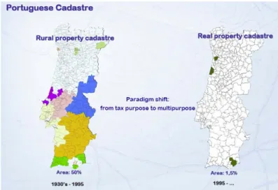
Figure 28 - Paradigm shift: from tax purpose to multipurpose (Julião, et al., 2010a) ... 35
Figure 29 - INSPIRE competencies (Cipriano, et al., 2013) ... 36
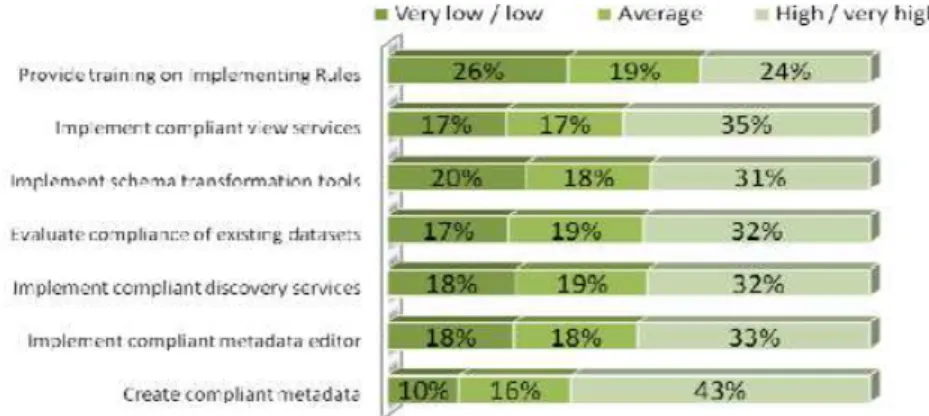
Figure 30 - Knowledge of INSPIRE (Cipriano, et al., 2013) ... 37
Figure 31 - INSPIRE UML data model for cadastral parcels (Seifert, 2012) ... 39
Figure 32 - The EuroGeographics vision on geospatial reference data (Jakobsson, 2012) .. 40
Figure 33 – Evolution of Geographic Information (Kim & Jang, 2012) ... 41
Figure 34 – Cloud GIS enables pervasive access, integrating traditional GIS with a whole new world of applications (Dangermond, 2012) ... 42
Figure 35 - Parts of a GIS (Tomlinson, 2011) ... 42
Figure 36 - CyberGIS Component Architecture (Wang, et al., 2013) ... 43
Figure 37 - Evolution of ICT in Land Administration (Mclaren & Stanley, 2011)... 44
Figure 38 - GIS - The platform for Land Administration (Jones, 2013) ... 45
Figure 39 – Cadastre Control (Ferbritas, 2012c) ... 46
Figure 40 - Why a Cadastre Information System? (Gil & Mata, 2011a) ... 46
Figure 41 - GIS and Railways (Bills, 2013) ... 47
Figure 42 - GIS and Railway Management (Koeppel & Engstrom, 2012) ... 47
Figure 43 - Augmented reality view of right and restriction boundaries in 3D (LINZ, 2014) .. 49
Figure 44 – FBSIC global calendar ... 52
Figure 45 – Prototyping life cycle (CMS, 2008) ... 53
Figure 46 – Waterfall model life cycle (CMS, 2008) ... 54
xxiii
Figure 48 – High level workflow of Ferbritas Expropriations Projects and Processes
(Ferbritas, 2010) ... 61
Figure 49 – Physical architecture (FBSIC phase 1) (Ferbritas, 2009) ... 67
Figure 50 – FBSIC v1.0 main stages (Ferbritas, 2010a) ... 69
Figure 51 – FBSIC v1.0 Physical Architecture (Ferbritas, 2010a) ... 71
Figure 52 – FBSIC v1.0 Conceptual Architecture (Ferbritas, 2010a) ... 72
Figure 53 – FBSIC project phase 1 (FBSIC prototype) final calendar (Ferbritas, 2010a) ... 73
Figure 54 – Load and Stress Tests: asynchronous mode example (Ferbritas, 2010a) ... 76
Figure 55 – FBSIC Central module web application initial screen (Ferbritas, 2010a) ... 76
Figure 56 – FBSIC phase 2 final calendar (Ferbritas, 2010a) ... 77
Figure 57 - FBSIC Central Module screen shot example (Ferbritas, 2012c) ... 82
Figure 58 - FBSIC map output example (Gil & Mata, 2012a) ... 82
Figure 59 – FBSIC v3.0.3 Layers Diagram (Ferbritas, 2011a) ... 83
Figure 60 – FBSIC v3.0.3 Conceptual Architecture (Gil & Mata, 2012a) ... 84
Figure 61 – FBSIC v3.0.3 Physical Architecture (Gil & Mata, 2012a) ... 84
Figure 62 – FBCADASTRO Entity-Relation diagram ... 85
Figure 63 – FBSIC Production teams work volume (September 30, 2010) ... 88
Figure 64 – FBSIC Production teams work volume (July 27, 2013) ... 88
Figure 65 – Special Achievement in GIS awarded by Esri Inc. to Ferbritas on July 13, 2011 ... 89
Figure 1.1 - Locate, connect and deliver spatial information (Rajabifard, 2009)……….….. 114 Figure 1.2 - From Data to Informed Decisions and Sustainable Actions (Teo, 2013) ... 115
Figure 1.3 - Place as an important factor to improve information manageability (Wallace 2007) cit. by (Rajabifard, et al., 2010) ... 115
Figure 2.1 – Schematic Layers of a Ubiquitous Sensor Network (ITU, 2008)……… 117 Figure 2.2 – Ubiquitous positioning for cadastral boundary mark system architecture
(Musliman, et al., 2012) ... 119
Figure 3.1 - Railway Public Domain Acquisition and Delimitation Macro Process…………. 122 Figure 3.2 - Cadastral survey preparation workflow ... 123
xxiv
Figure 3.4 - Cadastral Survey workflow ... 124
Figure 3.5 - Cadastral Survey Map ... 125
Figure 3.6 - Cadastral GIS workflow ... 125
Figure 3.7 - Expropriations Project workflow. ... 126
Figure 3.8 - Example of an Expropriations Project Map ... 126
Figure 5.1 - Cadastre Information System Phases Workflow (Ferbritas, 2010a)………….. 132 Figure 7.1 - Data Migration Module toolbars interfaces (Ferbritas, 2012d)………. 149 Figure 7.2 - Import structure toolbar: cartography mapping table interface (Ferbritas, 2012d) ... 149
Figure 7.3 - Field module interface (user authentication and cadastral parcel section)
(Ferbritas, 2012d) ... 151
Figure 7.4 - Field module’s operation cycle (Ferbritas, 2012d) ... 151
Figure 7.5 - Information processing module interface (Ferbritas, 2012d) ... 152
Figure 7.6 - FBSIC initial screen (Ferbritas, 2012d) ... 157
Figure 7.7 - Cadastral parcels report ... 157
Figure 7.8 - Land Property registry document ... 158
Figure 7.9 - Tax registry document ... 158
Figure 7.10 - Cadastral parcels map ... 159
Figure 7.11 - Expropriations Project map... 159
Figure 7.12 - Expropriations Project single parcel map (A4 format) ... 160
Figure 7.13 - Expropriations Project single parcel map (A3 format) ... 160
Figure 7.14 - Expropriations parcels area report ... 161
Figure 7.15 - Easy print map ... 161
Figure 7.16 - Approval module initial screen ... 164
Figure 7.17 - Approval module operation life cycle (Ferbritas, 2012d) ... 164
Figure 7.18 - Domain management module search screen (Ferbritas, 2012d) ... 167
Figure 7.19 - Central Module interface main features ... 174
Figure 7.20 - FBSIC Search Tool theme navigation flows (a: alphanumeric; g: geographic; a/g: alphanumeric and geographic) ... 179
1 1. INTRODUCTION
1.1. Framework
The project object of this report, Ferbritas Cadastre Information System (FBSIC), was developed between October 1, 2008 and October 12, 2012 in Ferbritas SA (FB) a Portuguese consultancy company owned by REFER (Portuguese National Railway Infrastructure Manager) known as REFER Engineering, SA since February 2013. The company is currently dedicated to the transport sector and in particular the railway (light, heavy, conventional and high speed).
The concepts of integration, complementarity and coordination are particularly important especially in the field of railway infrastructures. The requirements of the associated interventions are very technical in nature and involve multiple specialties and technologies, and the final result is only guaranteed if the various components of this interwoven puzzle are compatible and properly joined together. Moreover, linear infrastructures such as roads, rail, energy, etc. are long lasting, and with long lifecycles. Starting at the planning stage, these infrastructures can last for several decades, during which information is produced by multiple generations and organizations, running the risk of not being used at present, or future, or even get lost in time, if not properly organized and maintained. The resulting information and knowledge have high economic value and significance for organizations, making it vital to preserve.
Although the immediate reason for the development of this information system stems from the need to provide a complete answer to the dynamic control of the registration and real estate status of the national rail infrastructure, the results obtained are of relevance to individuals, companies and public administration. Land asset management is a cross cutting societal topic which is the basis for many economic and control activities. These results are very important since the opportunity and return on investment on, for instances, ownership transfers, land use and taxation cannot be based on inadequate or wrong information.
For these reasons, from the beginning, Cadastre Information System (FBSIC) was designed to meet the needs of the rail sector and beyond. It also is applicable to the activities of entities or organizations to which it is important to ensure the dynamic control of cadastral and real estate property.
FBSIC project framing presented in the next points is based on the 2011 article “Cadastre Information System for Rail in Portugal” (Gil & Mata, 2011e).
1.1.1. Why a Cadastre Information System?
2
Figure 1 – Availability of site for construction (Gil & Mata, 2011c)
Business demands that expropriations projects have to deliver various documents (drawings, spreadsheets, reports), thus information after being collected and consolidated, has to be distributed to a wide set of reports with completely different formats. Moreover, tools and methodologies available on early 2009 implied that many hours were lost into numerous files and folders manipulation and subsequent digital drawings reports information incorporation, with lots of time lost only with its composition.
Difficulties soon arise, first, in the assembly of the whole process, but they are intensified soon after if there would be a need for an update. In this case, there is a need to replicate the updated information so many times and how often it was initially distributed by different formats or files.
The facts above described framed company awareness to proceed with a solution implementation to highly improve the way information was traditionally captured and transformed; to enable right information to be found and shared across the enterprise, boosting its use in a productively manner; and to provide users with day-to-day tools and capabilities integration, where the majority of the procedures would be automated and within reach of a click (therefore, when someone needed to produce a map or report, this document should be preset and obtained by access to a tool, in a simple manner, according to the context in which the user is in the solution and problem that had to be solve).
1.1.2. FBSIC planning stage
wa th Fi ob pr sta de In In Be M im Th th co inv pr pr Fe ha re "d as properly e production
rst we proce bjectives we reconditions
andard desi esign and rel 1.1.3.
itially, a prot next stage, elow, in Figu odule interfa mages (on top
he project t erefore com oordinated b
volvement o romote intern remises. erbritas Cad as multiple eference sha democratizati
integrated w n and busines
eeded to upd ere detailed to start the ign with the lated develop FBSIC imple
totype was d we proceed
ure 2 is pres ace (v1.0) (a p of the base
Figure 2 - C
eam was d mposed by by a GIS tea of the first lev nal and exte
astre Inform purposes, p areholder, w ion" of knowl
with other inf ss managem
date the des d and the
project. Fro e establishm
pments. ementation st
developed to ed with the C
sented an illu as backgroun
e image).
Cadastre Infor
designed to functional am and sup vel of manag ernal resourc
ation System particularly re with efficienc
ledge in a tim
3
formation su ment.
ign of the te technologic om this poin ment of requ
tage
support bet Cadastre Info
ustration com nd image); e
rmation Syste
adequately units’ elem pported by a gement. Ano ces integratio
m (FBSIC) is elated to in cy of service meless frame
bsystems of
echnical and cal platform
t, the implem irements, fu
tter decisions ormation Sys
mposed of se examples of
em (v1.0) (Gil &
cover the ments that an informatio other conditi
on, was per
s the first ste crease valu es, informat ework.
f the organiz
business pr selected, mentation pr unctional ana
s on the syst stem (FBSIC
everal image module outp
& Mata, 2011e
needs of b have busin on systems on, that was rforming the
ep of a busin e for custom tion integrity zation, focus rocesses, the which were rocess follow alysis, appli
tem to imple C) implement
es: FBSIC C puts and ove
e)
usiness and ness "know-team, with s also essen work at Fer
4
FBSIC is used permanently by three business areas and has allowed to formulate new innovative services, and to respond to the needs expressed by clients. They were metrics established that had confirmed the efficiency gains and significant rigor established in pilot projects developed in the preliminary phase that would be confirmed after production entry at cruising speed.
1.1.4. Benefits of FBSIC project
FBSIC is supported by a scalable architecture, standards-based information technology and communication, and interoperability, ensuring a high sustainability of long-term application. It allows viewing and editing of geographic and alphanumeric information of cadastre and expropriations projects. It has a modular character, comprising:
• Data Migration Module (geographic and alphanumeric), with some features for element
validation;
• Field Module (information gathering activities support);
• Information Processing Module (field data import and validation);
• Central Module (provides tools that enable: information load and edit on a geographic,
alphanumeric and document basis, monitor the quality of the project phases and their transitions (workflow); print maps and formal documents, among other features);
• Backoffice Module (system administrator support);
• Approval Module (enables to perform an approval cycle of expropriations design data
before it is sent to DUP);
• Public Domain Management Module (enables to perform land parcels management
cycle till their acquisition by the national authorities).
In Figure 3 are shown interface examples of the following modules: Data Migration, Field Module, Information Processing, and Approval.
5
The benefits are evident at the level of operational efficiency, with the inclusion of tools that enable process integration and standardization of procedures, facilitate analysis and quality control and maximize performance in the acquisition, maintenance and management of cadastre and expropriations information (expropriations projects). The implemented system achieves levels of robustness, comprehensiveness, openness, scalability and reliability suitable for a structural platform.
1.2. Objectives
The project report objective is, to review in detail all the aspects related with the implementation projects of an enterprise Geographical Information System (GIS) FBSIC, to support Cadastre and Expropriations activities in Ferbritas, SA (actually known as REFER Engineering, SA) from its early planning stage to the last maintenance phase (covering about four years); present a final overview and main conclusions.
From the beginning, FBSIC was designed to meet the needs of land in the rail sector (right-of-way), where Ferbritas is positioned, and beyond, as a generic cadastre tool, since it’s also applicable to entities or organizations activities to which it is important ensure cadastral and real estate property dynamic control.
The processes of land mobilization for public and private domain infrastructures are developed according to proper legal frameworks and systematically confronted with the impoverished national situation as regards the cadastral identification and regularization, which leads to big inefficiencies, sometimes with very negative impact to the overall effectiveness.
1.3. Report organization
In short, I will make a guided tour from the beginning of the early planning stages; then I will make a stop at the main implementations that comprise FBSIC, and talk about the several integrations achieved with other subsystems, both from an inward perspective (what was implemented and why) and from an outward perspective (how were the solutions developed at a high level perspective) with an emphasis in project management; then I will refer the production activities carried out in parallel to the implementation works; and I will point out the presentations, conferences, articles and awards where FBSIC was an actor.
Finally, I will present a summary, the report main conclusions, and some future references.
1.4. Main personal contributions to Cadastre Information System 1.4.1. Main activities and responsibilities
I was the Geographic Information Officer and Head of the GIS Department at Ferbritas S.A. between October 2010 and April 2013 (1st line manager reporting directly to Company’s
6
• Consolidate and extend the company’s Geographic Information Systems skills, in
accordance with the board strategic guidelines, providing increased business, marketing and technical support in GIS. I aimed to drive my conduit by quality principles, efficiency, efficacy, simplifying procedures, cooperating and communicating in an effective way;
• Conceive, plan, submit to board approval, manage and monitor the yearly GIS
team/department activities and budget; lead FBSIC project teams that integrate other company units and external suppliers; FBSIC project champion; responsible for quality control of GIS solutions, and FBSIC users (internal and external) trainer;
• Coordinate the development of the corporate geographic information platform,
understood as an added value product for railway studies and project departments, and other company’s functional units. In this context, I lead the production teams of Cadastral Recovery of Rail Public Domain GIS projects, Railway Infrastructure GIS projects, Land Administration Systems, and Expropriation GIS projects;
• Contribute to REFER (Portuguese Railway Infrastructure Manager) GIS standard
(Cartography and Railway Projects);
• GIS Project Management in Cadastre and GIS unit, GIS software manager (Esri ArcGIS
Desktop/Server 10.1), Geodatabases manager (SQL Server 2008 R2), GIS modelling (model builder), user support and development of simple Web GIS Apps (ArcGIS Viewer for Flex v3.6);
• Present Ferbritas GIS solutions internally and in national and international fora (about
38 presentations between 2008 and 2012: 1-2008, 7-2009, 11-2010, 8-2011, 11-2012.
See Annex 9 where FBSIC main presentations list between 2010 and 2012 is
presented), and support board marketing initiatives related to GIS solutions.
Relating to the professional activity referred previously, I highlight the article, case studies, technical documents, posters and application manuals in which I collaborated, being responsible by all technical contents, text and figures, which are presented in section 4. In what respects my participation in FBSIC project, I highlight the subsequent features: coordination and project management from end to end through initiating, planning, executing, monitoring, controlling, closing stages, and later guarantee and maintenance periods, between October 2008 and October 2012; and the following interventions:
• Semantic gaps bridge between software development team and business users;
• Database modelling collaboration;
• Interface definition and design participation;
• Workflows definition collaboration;
• Requirements gathering and analysis participation;
• FBSIC solution software tester;
7
2. LITERATURE REVIEW
The following sections contain a brief literature review of the main themes related to the topic of this report, such as: Land Administration, Cadastre, and GIS with emphasis to the relationships between them.
2.1. Land Administration 2.1.1. Land
The concept of land includes properties, utilities, and natural resources, and encompasses the total natural and built environment within a national jurisdiction, including marine areas (Williamson, et al., 2010).
Land can be viewed from a variety of perspectives, depending on the context within which it is being discussed, as exposed in Figure 4.
Figure 4 - Perspectives on land (United Nations, 2004)
Therefore, land has many different meanings in a society, and even to the same person. Those could include (Zevenbergen, 2002):
• economical asset (for industry, but especially for commercial farming);
• social security (especially for subsistence farming);
• place to live (compare the Habitat Global Campaign on Secure Tenure);
• ‘a family heirloom’ (like castles and mansions in England):
• power base for jurisdictions (governments in exile miss this very much);
• place to put down transport links;
• places of social-cultural importance (worship, historical monuments etc.), etcetera.
The way it is ‘defined’ differs between those approaches. Land is preliminary defined by the use of patterns, which if enough individualized and supported at some point by a legal construct, can be ‘owned’. Even then a difference can exist between ownership and use (…) (Zevenbergen, 2002).
8
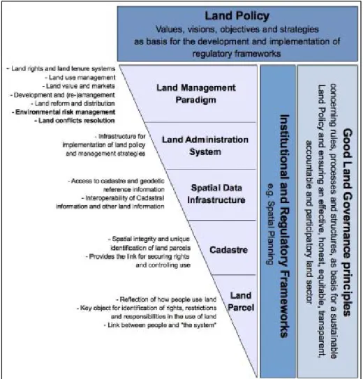
The land sector in a particular country is evidently a complex system composed by quite an extensive list of technical and legal aspects that have direct impact on economic development and environmental as well as social dimensions. Land policy, as the overall guideline for the formulation of regulatory frameworks and tools with respect to land and stating the values and objectives to be followed by the land sector, sets the basis for the construction of healthy land tenure systems (Antonio, et al., 2014).
As shown in Figure 5, under these frame conditions, there are a number of hierarchical levels. In this regard, Enemark (2009) cited by (Antonio, et al., 2014), argues that this hierarchy shows the complexity of organizing policies, institutions, processes, and information for dealing with land in society. This conceptual understanding provides the overall guidance for building a land administration system in a given society, independent of the level of development. The hierarchy should also provide guidance for adjusting or reengineering an existing land administration system.
9
It is now internationally accepted that poverty, land rights, conflict and the sustainable use of natural resources are correlated, and that secure access to land for the rural poor is fundamental to improving their livelihoods. Furthermore, asset ownership by the poor is increasingly recognized as essential to sustained, broad-based economic growth (ILC, 2005).
Land is thus a scarce resource involving a wide range of rights and responsibilities. When poorly managed, it can become contentious often leading to disputes, conflict, degradation and other problems, all of them drivers of slum development and poverty in urban areas (Clos, 2011).
2.1.2. Land Administration
Land administration is not a new discipline. It has evolved out of the cadastre and land registration areas with their specific focus on security of land rights (Williamson, et al., 2010). Land administration systems (LAS) are about addressing land tenure, land value, land use, and land development problems by providing a basic infrastructure for implementing land related policies and land management strategies to ensure social equity, economic growth and environmental protection.
The evolution of LAS is influenced by the changing people to land relationships over the centuries. Even though Figure 6 depicts a Western example of this evolving relationship, a similar evolution can be plotted for most societies (Williamson, 2008). This diagram highlights the evolution from feudal tenures, to individual ownership, the growth of land markets driven by the Industrial Revolution, the impact of a greater consciousness about managing land with land use planning being a key outcome, and, in recent times, the environmental dimension and the social dimension in land (Ting and others, 1999) cit. by (Williamson, 2008).
10
environmental or cultural reasons. Land administration is the governmental responsibility to provide security of tenure and information about tenure issues for property markets and governmental and private business activities (UN-HABITAT, 2012).
Building effective and enduring land administration systems requires long-term investment and continuing support. Although land records are expensive to compile and to keep up to date, a good land administration system produces many benefits (UNECE, 2005).
Likewise, one vision for a fully automated system would include more than just a GIS - other computer-based components such as document management system, database management system, and resolution of organizational and legal problems. Such a system would support not only mandated land records management responsibilities of local jurisdictions, but would also serve the needs of a broad range of actors using land information for a wide variety of programs and functions (Ventura, 1997).
Though, land administration is part of the infrastructure that supports good land management it should be treated as a means to an end, not an end in itself (UNECE, 2005).
So, land administration can be considered as basis for good governance, in fact, intelligent and effective land administration systems are a solid condition for good governance and economic development. This concerns developments regarding legal security (a basic requirement for investors), access to credit (mortgage), spatial planning (in support of economic and environmental development) and effective and efficient land taxation. In case this is not well organised, there may be many disputes, frustrating efficient land use. Therefore, protection of ownership through property registers is an important condition for good governance and sustainable economic development (de Zeeuw & Salzmann, 2011). CheeHai Teo goes further on (Lemmen, 2013) to explain ‘fit for purpose’ we could, in a simplistic manner, say the following: it has to be applicable, it has to be appropriate – relevant to the contexts we are working with – and it has to be affordable. Therefore, when designing our intervention, we need to carefully consider the context and culture, the capacities and scale, the opportunities and options, the ability to innovatively and incrementally enhance the effectiveness and efficiency of the intervention at that point in time. And all of that with an eye on achieving maximum benefits.
In fact, an effective land administration is more than the provision of a register. Good data acquisition, management and distribution is essential, but if E-governance and a spatial enabled society are in place, it’s impact on good governance can be improved substantially (Zeeuw, et al., 2013).
11
Figure 7 - A global land administration perspective (Enemark, 2004)
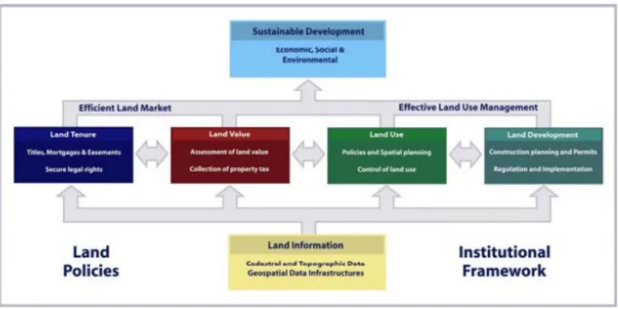
The four land administration functions are different in their professional focus. Even if land administration is traditionally centred on cadastral activities, modern LAS deliver an essential infrastructure and encourage integration of the processes related to land tenure (securing and transferring land rights); land value (valuation and taxation of land); land use (planning and control of the use of land); and land development (implementing utilities, infrastructure and construction planning). The four functions interact to deliver overall policy objectives, and they are facilitated by appropriate land information infrastructures that include cadastral and topographic datasets linking the built and natural environment (Enemark, 2013).
Lately, the land administration sector is developing data, standards, technologies and infrastructures as the basis for good land administration practices. In setting up a system, products should be used and developed, considering two important aspects according to (Zeeuw, et al., 2013):
1. The required investment made in tools and products, to make it possible. The investment that is needed in setting up a LAS can be defined by three components (in each, I refer a group of select features mentioned in the original work):
a. Data and standards (…)
b. A method for the collection of data, management of the systems (software) and the distribution of data, information and knowledge (…)
• data distribution - internet based web services (Web mapping Services, (WMS) and Web Feature Services (WFS)), introducing new concepts like Software As A Service (SAAS));
c. Choices on the system: people and organisations, service levels and infrastructure.
12
2. The required return on investment in products, processes and services, to make it feasible:
a. Based on the societal demand, strategic decisions should be made (…)
b. Return on investment can be obtained on data, information and knowledge or a mixture of these.
• For example, the Dutch Kadaster manages a database with more than nine million parcels (spatial and legal data). On yearly basis, about 25% of the Kadasters turn-over is generated by the provision of information products derived from this database.
Furthermore, the benefits of good land administration according to (Mclaren & Stanley, 2011) are shown in Figure 8.
Figure 8 - Benefits of Good Land Administration (Mclaren & Stanley, 2011)
Nevertheless, and according to (Enemark, et al., 2014), the approach used for building land administration systems in less developed countries should be flexible and focused on citizens’ needs, such as providing security of tenure and control of land use, rather than focusing on top-end technical solutions and high accuracy surveys. A fit-for-purpose approach includes the following elements:
• Flexible in the spatial data capture approaches to provide for varying use and
occupation.
• Inclusive in scope to cover all tenure and all land.
• Participatory in approach to data capture and use to ensure community support.
• Affordable for the government to establish and operate, and for society to use.
• Reliable in terms of information that is authoritative and up-to-date.
• Attainable in relation to establishing the system within a short timeframe and within
available resources.
• Upgradeable with regard to incremental upgrading and improvement over time in
13
A final reference to the Land Governance Assessment Framework (LGAF), a diagnostic tool, intended as a first step to help countries deal with land governance issues.
The core version of LGAF comprises a set of detailed indicators to be rated on a scale of precoded statements (from lack of good governance to good practice) based, where possible, on existing information. These indicators are grouped within five broad thematic areas that have been identified as major areas for policy intervention in the land sector (Deininger, et al., 2012):
• Legal and institutional framework (…)
• Land use planning, management, and taxation (...)
• Management of public land (…)
• Public provision of land information (…)
• Dispute resolution and conflict management (…)
Therefore, the LGAF provides a holistic diagnostic review at the country or regional levels that can inform policy dialogue in a clear and targeted manner (Enemark, et al., 2014).
2.1.3. Land Management Paradigm
The cornerstone of modern land administration theory is, according to (Williamson, et al., 2010), the land management paradigm, in which, land tenure, value, use and development are considered holistically as essential and omnipresent functions performed by organised societies (Figure 9).
Figure 9 – The land management paradigm (Enemark, 2004) cit. by (Williamson, et al., 2010) Land management activities reflect drivers of globalization and technology. These stimulate the establishment of multifunctional information systems, incorporating diverse land rights, land use regulations, and other useful data. A third driver, sustainable development, stimulates demands for comprehensive information about environmental, social, economic, and governance conditions in combination with other land related data (Williamson, et al., 2010).
14
2010). Moreover, in Figure 10 is presented (Zeeuw, et al., 2013) view of land administration in relation to sustainable development.
Figure 10 - Land administration in relation to sustainable development (Zeeuw, et al., 2013) In Portugal, large steps towards land management paradigm implementation took place with the creation, in 2006, of the SiNErGIC project.
The SiNErGIC project vision was to create, under the coordination of Portuguese Geographic Institute (IGP), the Unique Parcel Information according with a shift of paradigm in Public Administration of looking for integrated, articulated and add-value solutions. On the other hand, and in accordance with the vision, it was defined a set of main goals to create the information system infrastructure to serve citizens, owners as well as State allowing them to access in one-stop spot to legal, fiscal and spatial parcel characterization (Julião, et al., 2010) (Roque, 2009).
Lately, SiNErGIC project is being reformulated in a new project designated the Cadastre Information National System (DGT, 2013).
2.1.4. Land Administration Domain Model 2.1.4.1. Goals and Basic Features
The Land Administration Domain Model (LADM) received ISO official approval as an official International Standard on 1st November 2012, as ISO 19152:2012 (ISO, 2012). LADM among other features, defines terminology for land administration, based on various national and international systems.
LADM will serve two goals, mainly (Uitermark, et al., 2010):
1. Provide a basis for the development of Land Administration systems (LA systems); 2. Enable involved parties, both within one country and between different countries, to
communicate, based on the shared vocabulary (that is, an ontology).
On the other hand, LADM defines a reference model, covering basic information-related components of LA. Basic components relate to the following (Uitermark, et al., 2010):
1. Parties (people and organizations).
15 3. Spatial units (parcels, buildings and networks). 4. Spatial sources (surveying).
5. Spatial representations (geometry and topology).
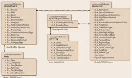
Additionally, and according to (Seifert, 2012) is shown in Figure 11 an overview of LADM packages (with their respective classes).
Figure 11 - Overview of LADM packages (with their respective classes) (Seifert, 2012)
(Hespanha, et al., 2013) state that LADM provides a generic data model for land administration based on common grounds. It is possible to use it in so-called informal and customary environments (Figure 12). This provides a basis to apply the model to support equal land rights for all. To support in avoidance of land grabbing by mapping the existing situation fast and with unconventional approaches as point cadastres, satellite images, boundary drawing instead of measuring, with participatory approaches, accepting errors and with the intention to improve quality later. With its broad functionality LADM can support in the development of concepts for land administration systems, which can support administration of multiple types of tenure. This is also valid for the Social Tenure Domain Model (STDM), presented later on.
Figure 12 - Further alignment with LADM developments is needed (Hespanha, et al., 2013)
2.1.4.2. Portugal Country Model
“D In ce sp ow en th inf in al Th co se ge Ac ad ef co gu la To m ke po an So ea Development Portugal, m entury to the pecifications, wnership and nd result is t
e country te formal legal Portuguese ., 2010).
2.1.5. T he Global La ontributing to ecurity of ten ender-sensiti
ccording to dministration ffect. The te onducting a uidelines and nd tool and a o reach the
anagement a ey land tools overty and la n advanced ocial Tenure arly stages o
t methodolog modelling of t
e first decad there’s a d (2) local co
he absence rritory. Furth status, as th ), will form a
The Global L and Tool Netw
o poverty al nure particul ive land tools
(GLTN, 201 and manag erm covers a survey, a s d approache apply it (or ad e overall go
and security s (presented and issues a stage of de Domain Mo f developme
Fi
gy for an inte he Cadastra de of the X focus on ju ommunity ow
of a strict v hermore, con he Deferred C areas that co
Land Tool Ne work (GLTN lleviation thr arly through s (GLTN, 20 12a) a land gement. It is
a wide rang set of softwa
s. The emph dapt it) to the oal of pove y of tenure, th
in Figure 1 at the country
evelopment odel and Gen ent (GLTN, 20
gure 13 - GLT
16 egrated lega al Domain ha XXI century,
ust two of t wnership, om
iew of a plan nsideration of
Cadastre or uld overlap p
etwork (GLTN ) is an allian rough land r
the develop 12).
tool is a p s a way to p e of method are and acc hasis is on p eir own situa erty alleviatio
he GLTN Pa 3) which ne y level, acro and are bei nder Evaluati
012a).
TN Diagram T
l cadastre” ( as evolved si where bas the three fo mitting thus p nar partition, f transitional the Urban A private Real
N)
ce of global reform, impr pment and d
practical way put principles ds: from a s companying practicality: u ation.
on through artners are in ed to be ad ss all region ng tested in ion Criteria),
ools (GLTN, 2
(Hespanha, 2 ignificantly fr
ed on the orms of pro public doma , once there
areas that a Areas of Illega Property pa
regional and roved land disseminatio
y to solve a s, policies a simple chec protocols, o users should
land reform n the process ddressed in o ns. Some of
n selected c whereas oth
2012a)
2012) PhD t rom the end latest Portug operty: (1) p
in ownership will be gaps are currently
al Genesis (A rcels (Lemm
d national pa managemen n of pro-poo
a problem in nd legislatio klist to use or a broad s be able to t
m, improved s of developi order to dea these tools countries (e.g
17
The Land Tool Development section of the above referred website provides two links, i.e. Themes, in which the tools are embedded, and Cross Cutting Issues (GLTN, 2012a).
2.1.6. Social Tenure Domain Model (STDM)
Where there is little land information, there is little or no land management. Conventional Land Administration Systems are based on the ‘parcel approach’ as applied in the developed world and implemented in developing countries in colonial times. A more flexible system is needed for identifying the various kinds of land tenure in informal settlements or in customary areas (Lemmen, 2010).
Traditional land surveys are costly and time consuming. For this reason alternatives are needed; e.g. boundary surveys based on handheld GPS observations, or by drawing boundaries on satellite images. This means of course a different accuracy of co-ordinates. Surveyors understand this and surveyors are needed to provide quality labels and to improve the quality of co-ordinates at a later moment in time (Lemmen, 2010).
In this same direction (Hespanha, et al., 2013) states that flexibility is needed in relation to the way of recording, the type of spatial units used, the inclusion of customary and informal rights, the data acquisition methodologies and in the accuracy of boundary delineation. It is less important to produce accurate maps. It is more important to have a complete cadastral index map and to know how accurate the map is.
In this context, UN-HABITAT develops an initiative to support pro-poor land administration: The Social Tenure Domain Model (STDM).
Because, as stated by (Augustinus, 2010a), currently, most poor people are not covered by a land administration system and its linked land information management system. This means that they do not benefit from these systems in regard to tenure security, planning and service delivery, slum upgrading, resolution of disputes and so on. STDM would make it possible for a country and/or local government to go to scale and include low-income people in their information systems and in their land delivery approaches. This would have a direct impact on the quality of life of the poor and on poverty reduction. It would also have a direct impact on the stabilisation and governance of cities, also through the empowerment of the poor. This is because it is not possible to create sustainable cities if the poor are not part of the solution.
18
Moreover, the work presented in (Paasch, et al., 2013) paper show that it is possible to extend the Land Administration Domain Model, LADM and its code lists, using the Legal Cadastral Domain Model, LCDM and the Social Tenure Domain Model, STDM, to making it possible to describe non-formal rights, restrictions and responsibilities; it’s also recommended by the authors further research in this issue.
In agreement with previously arguments (Hespanha, et al., 2013) states that LADM provides a generic data model for land administration based on common grounds. It is possible to use it in so-called informal and customary environments. This provides a basis to apply the model to support equal land rights for all. To support in avoidance of land grabbing by mapping the existing situation fast and with unconventional approaches as point cadastres, satellite images, boundary drawing instead of measuring, with participatory approaches, accepting errors and with the intention to improve quality later. With its broad functionality LADM can support in the development of concepts for land administration systems which can be in support administration of multiple types of tenure. This is also valid for the Social Tenure Domain Model (STDM).
2.1.7. Solutions for Open Land Administration (SOLA)
To support the issues referred above, concerning computerised cadastre and registration systems in developing countries, was launched, in mid-2010, the Solutions for Open Land Administration (SOLA) Project.
SOLA is an open source software system that aims to make computerised cadastre and registration systems more affordable and more sustainable in developing countries. Three countries (Samoa, Nepal and Ghana) have been identified for pilot implementation of the software (FAO, 2013).
According to FIG/FAO booklet (FIG and FAO, 2010) the costs of proprietary software licenses have proved to be a constraint, but even more, the lack of capacity, models and support to develop software have stopped initiatives. Open-source software, which has become a credible alternative to proprietary software, provides a way forward. Open-source solutions are more flexible and adaptable to local conditions and languages than proprietary software. By using and improving open-source software, cadastres can build local knowledge and contribute to the development of open-source projects that can in turn benefit other cadastres worldwide.
Finally, I would like to refer that, it is already possible to proceed with the installation of the SOLA Release Candidate Web Start applications, and install and configure the development tools used for SOLA, with the support of the SOLA Developer Setup Bundle (FAO, 2013).
2.1.8. Crowdsourcing land administration information
19
managing and distributing the information are accelerating the growth of crowdsourcing and distributed citizen sensing.
In this context, crowdsourcing is being used to improve public confidence in land administration records in several countries in Europe and Central Asia. Land records are now available through the Internet and citizens are encouraged to report discrepancies so they can be corrected (Tonchovska, et al., 2014).
But, the challenge for land professionals is not just to replicate elements of their current services using crowdsourcing, but to radically rethink how land administration services are managed and delivered in partnership with citizens. Land administration by the people can become a distinctly 21st century phenomenon (Mclaren, 2011).
2.2. Cadastre
2.2.1. Cadastre definition
2.2.1.1. Before 1995 FIG Statement
At Commission 7 Opening Address at the 1990 FIG Congress a set of clear and concise cadastral definitions were presented, as follows (Henssen & Williamson, 1990):
• Land Registration: is a process of official recording of rights in land through deeds or as title (on properties). It means that there is an official record (the land register) of rights on land or of deeds concerning changes in the legal situation of defined units of land. It gives an answer to the questions "who" and "how";
• Cadastre: is a methodically arranged public inventory of data concerning properties
within a certain country or district, based on a survey of their boundaries. Such properties are systematically identified by means of some separate designation. The outlines or boundaries of the property and the parcel identifier are normally shown on large-scale maps, which, together with registers, may show for each separate property the nature, size, value and legal rights associated with the parcel. It gives an answer to the questions "where" and "how much";
• Land recording:
o land registration and cadastre usually complement each other; they operate as
interactive systems. Land registration puts, in principle, the accent on the relation subject-right, whereas cadastre puts the accent on the relation right-object. In other words: the land registration answers the questions as to who and how the cadastre answers the questions as to where and how much;
o because land registration and cadastre ("who and how" along with "where and how