20
Scientifi c Drilling, No. 2, March 2006 Progress ReportsProgress Reports
Lake Qinghai Scientifi c Drilling Project
by An Zhisheng, Ai Li, Song Yougui, and Steven M. Colman
doi:10.2204/iodp.sd.2.05.2006
Lake Qinghai in the People’s Republic of China covers 4400 km2 on the northeastern margin of the Tibetan Plateau
,at an elevation of 3194 m (Fig. 1). The lake is extremely sensitive to changes in climate because it lies in a critical transitional zone between the humid climate region controlled by the East Asian monsoon and the dry inland region affected by westerly winds. Three major atmospheric circulation systems affect its climate: (i) the winter monsoon, induced by Siberian high pressure and associated high-latitude ice cover, (ii) tropical moisture from low high-latitudes, carried by the East Asian summer monsoon, and (iii) climatic changes in the North Atlantic region, the effects of which are inferred to be transmitted via the westerlies. A study of drill cores from the lake and the surrounding area is critical for understanding the climatic, ecological, and tectonic evolution of the area, including the development of the East Asian monsoon system and its relationship to major global atmospheric circulation.
Lake Qinghai occupies a closed tectonic depression, or piggy-back basin, on the upper plate of a major, active thrust fault. The basin is bound to the north by the Qilian Mountains,
which constitute the northeastern margin of the Tibetan Plateau. The lake basin thus is intimately related to the active tectonics of the Tibetan Plateau. Seismic-refl ection data show that the lake sediments are tectonically deformed in some parts of the basin and largely undeformed in other parts, where they should record at least the timing of regional tectonism. The seismic surveys indicate that the shallow lake is underlain by northern and southern sub-basins and that the southern sub-basin contains a continuous strati-graphic sequence of unconsolidated sediments more than 700 m thick.
At an international workshop in Xining, China in October 2003, the Qinghai Drilling Project was planned to obtain a series of cores from at least four different sites, penetrating 200–700 m into the lake sediment and possibly reaching Pliocene or older strata. Other sites with shallower penetra-tions of 5–50 m were planned to target specifi c high-resolution climatic intervals in the Holocene and last several glacial cycles. The overall scientifi c objectives of the project are listed below.
Scientifi c Drilling, No. 2, March 2006
21
• To obtain an improved understanding of the late Cenozoic environmental history of the Lake Qinghai region and the development of the East Asian monsoon climate
• To understand the Late Cenozoic tectonic evolution of the Lake Qinghai basin and the growth of the northeastern margin of the Tibetan Plateau and its effects on regional climate
• To correlate Lake Qinghai environmental records with other regional and global paleoclimatic records to obtain a better understanding of the connection between regional climatic change, the development of the East Asian monsoon system, prevailing westerlies, and, ultimately, the evolution of global climate
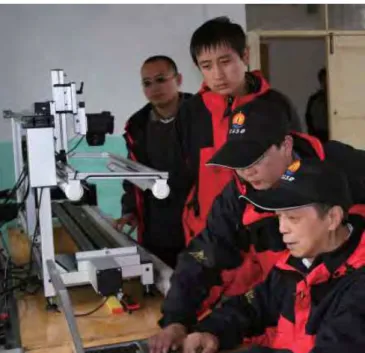
After several weeks of delay caused by poor weather and a regional outbreak of bird fl u, drilling operations began in late July 2005 and continued to early September. The drilling was conducted from a barge with the Global Lake Drilling 800 m (GLAD800) coring system (Fig. 2), the modular ICDP drilling platform and drilling system operated by the Consortium for Drilling, Observation and Sampling of the Earth’s Continental Crust (DOSECC). DOSECC’s coring operations were supported by the Qinghai Geology Survey and scientists from the Xi’an Institute of Earth Environment of the Chinese Academy of Sciences (IEECAS, Fig. 3). The sediment cores were described initially onboard by observing through the plastic core liners and examining core-catcher samples. The maximum 1.5-m-long core segments were scanned for petrophysical properties with a GEOTEK instrument at a shore base that was occupied throughout the drilling operations.
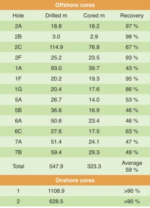
In total, 324 core runs for 548 m of drilling acquired 323 m of core at an average recovery rate of 59% (Table 1). The upper few tens of meters of sediment were mainly gray clay and silty clay. Core recovery was excellent in this upper part of the lake bed, and these cores will serve for the planned high-resolution study of climatic changes extending through much of the last glaciation. The sediment below the clay-rich upper section was mainly rather fi ne-grained, unconsoli-dated sand with only a few clayey layers. The character of
these sandy units plus the persistent rough wind and wave conditions experienced during the drilling operation greatly hindered the recovery of good cores. The principal investi-gators thus decided to postpone the proposed 700-m drilling for a future campaign and to focus on obtaining high-quality, overlapping cores of the upper 30–50 m of relatively fi ne-grained sediment at several sites (Fig. 1). Hole 2C penetrated the deepest (114.9 m), and the cores from this site may provide paleoenvironmental information through the late Pleistocene.
Concurrently with offshore drilling, an onshore site was drilled successfully on Erlang Jian on the southeastern shore of the lake (Fig. 1) using Chinese equipment (Fig. 4). The drill rig was deployed to its maximum drillstring capacity, allowing coring down to 1108.9 m, with an average recovery of more than 90% (Table 1, Fig. 5). Comparison to fi eld exposures suggests that the lowermost sediment recovered has a maximum age of late Miocene. The onshore drilling was conducted by the Qinghai Geology Survey, in collabo-ration with the IEECAS. Encouraged by the initial success,
Figure 2. The GLAD800 drilling system towed away from the dock site for fi rst coring.
Figure 3. ICDP´s optical core scanning system in use at the shore base.
22
Scientifi c Drilling, No. 2, March 2006the team drilled a second borehole at Yilang Jian and retrieved another 628.5 m of core.
All drill cores were shipped in refrigerated trucks to the IEECAS in Xi’an, China for storage at 2–5°C. So far, about sixty scientists from China, Japan, Europe, and North America have expressed interest in participating in upcoming studies. The principal investigators Z. An, S.M. Colman, G. Haug, P. Molnar, and T. Kawai and the science team members are planning a science coordination and sampling meeting as soon as samples can be made available after opening and fully describing the cores.
Acknowledgements
About 500 scientists, engineers, and technicians from the People’s Republic of China and abroad worked at and visited the drilling sites, mainly from the Chinese Academy of Sciences, the Ministry of Science and Technology of China, the National Science Foundation of China, the China Meteorological Association, the ICDP, and several univer-sities and research organizations, as well as local govern-ments. China Central Television and other TV stations and newspapers gave enthusiastic attention to this scientifi c research. They are all thanked for their contributions.
Authors
An Zhisheng, Institute of Earth Environment, CAS, 10 Fenghui South Road, Xi'an High-Tech Zone, Xi'an, 710075, People’s Republic of China, e-mail: [email protected].
Ai Li, Institute of Earth Environment, CAS, 10 Fenghui South Road, Xi'an High-Tech Zone, Xi'an, 710075, People’s Republic of China.
Song Yougui, Institute of Earth Environment, CAS, 10 Fenghui South Road, Xi'an High-Tech Zone, Xi'an, 710075, People’s Republic of China.
Steven M. Colman, Large Lakes Observatory & Department of Geological Sciences, University of Minnesota-Duluth, RLB, 2205 East 5th Street, Duluth, Minn. 55812, U.S.A.
Related Web Link
http://qinghai.icdp-online.org
Figure Credits
Figure 2 by Ronald Conze (ICDP).
All other figures courtesy of the Lake Qinghai Drilling Project.
Progress Reports
Figure 5. Lithology of the onshore core from Erlang Jian.
Table 1: Drill holes, core recovery, and statistics of coring.
Offshore cores
Hole Drilled m Cored m Recovery
2A 18.8 18.2 97 %
2B 3.0 2.9 98 %
2C 114.9 76.8 67 %
2F 25.2 23.5 93 %
1A 93.0 39.7 43 %
1F 20.2 19.3 95 %
1G 20.4 17.6 86 %
5A 26.7 14.0 53 %
5B 36.6 16.9 46 %
6A 50.6 23.4 46 %
6C 27.6 17.5 63 %
7A 51.4 24.1 47 %
7B 59.4 29.3 49 %
Total 547.9 323.3 Average
59 %
Onshore cores
1 1108.9 >90 %