TABLE OF CONTENTS
Preface ... 1
Mariana Diniz
The Portalón at Cueva Mayor (Sierra de Atapuerca, Spain):
a new archaeological sequence ... 3
Ortega, A.I.; Juez, L.; Carretero, J.M.; Arsuaga, J.L.; Pérez-González, A.; Ortega, M.C.; Pérez, R.; Pérez, A.; Rodríguez, A.D.; Santos, E.; García, R.; Gómez, A.; Rodríguez, L.; Martínez de Pinillos, M.& Martínez, I.
Torca l’Arroyu: A new holocene site in the centre of Asturias (North of Spain) ... 11
Rogelio Estrada García, Jesús F. Jordá Pardo, Joan S. Mestres Torres and José Yravedra Sainz de los Terreros
From “Inland Neolithic” to “Neolithic dwelling in the inland”: the role of homogeneous and heterogeneous elements on the explanation
of earlier agricultural stages in Central Spain ... 19
Enrique Cerrillo Cuenca
Néolithisation et structure sociale: données et discussion dans le nord-est
de l’Espagne ... 29
Xavier Clop; Juan Francisco Gibaja
El Valle de Ambrona (Soria, España): un referente cronológico para la primera
ocupación neolítica del interior peninsular ... 35
Manuel A. Rojo-Guerra, Rafael Garrido-Pena e Íñigo García-Martínez-de-Lagrán
Neolithisation process in lower Tagus valley left bank: old perspectives
and new data... 43
César Neves, Filipa Rodrigues, Mariana Diniz
Early Neolithic at the Serpis Valley, Alicante, Spain ... 53
J. Bernabeu Aubán, LL. Molina Balaguer, T. Orozco Köhler, A. Diez Castillo, C.M. Barton
Sources of monumentality: standing stones in context
(Fontaínhas, Alentejo Central, Portugal)... 61
Manuel Calado, Leonor Rocha
Castelo Belinho (Algarve, Portugal) and the first Southwest Iberian Villages ... 71
LIST OF FIGURES
Fig. 1.1. Geografical situation of the Sierra de Atapuerca and the main pleistocene
and holocene sites ... 4
Fig. 1.2. Scaled plan of the Portalón de Cueva Mayor site indicating the different excavations areas... 5
Fig. 1.3. Sratigrafical sequence of the northern and southern profiles from Portalón de Cueva Mayor site indicating the different excavations areas ... 6
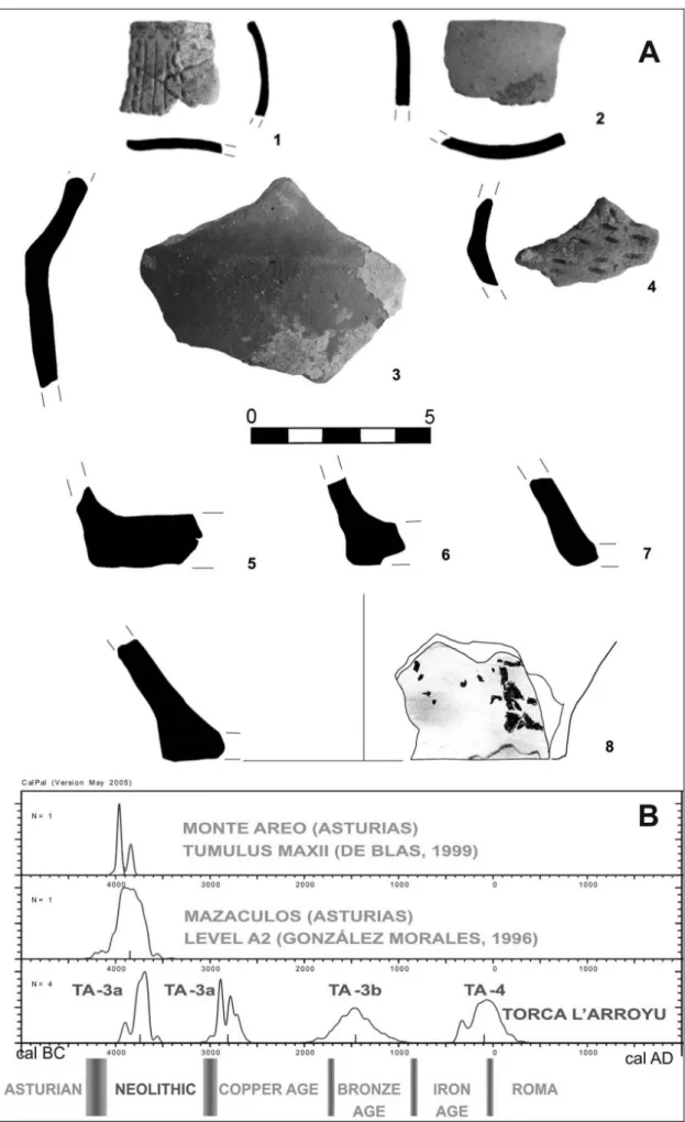
Fig. 2.1. A: Geographical location of Torca l’Arroyu. B: Stratigraphical scheme with indication of 14C samples. C: Polished lithic materials of Torca l’Arroyu... 12
Fig. 2.2. A: Pottery of Torca l’Arroyu. B: Calibrated 14C dates, regional parallels and chronology... 14
Fig. 3.1. Location of some Early Neolithic sites cited in text ... 20
Fig. 4.1. Pratiques funéraires néolithiques dans le nord-est de la Péninsule ibérique... 31
Fig. 4.2. Sépulture individuelle de la nécropole de Sant Pau del Camp (Barcelone)... 32
Fig. 4.3. Sépulture individuelle de la nécropole de Bòbila Madurell (Barcelone) ... 32
Fig. 5.1. Localización de los yacimientos de La Revilla del Campo y La Lámpara en Ambrona (Soria). Planta de las estructuras excavadas en La Lámpara. Planta de las estructuras excavadas en La Revilla del Campo ... 36
Fig. 5.2. Situación de las muestras datadas por 14C en la estructura 4 de La Revilla del Campo (Ambrona) (A); y en el hoyo 9 de La Lámpara (Ambrona) (B)... 39
Fig. 6.1. Early Neolithic sites in Portugal: LTV as “no-man´s land”... 44
Fig. 6.2. Megalithic monuments in Portugal: no information on LTV ... 45
Fig. 6.3. Calibrated radiocarbon chronology of late Mesolithic, early and middle Neolithic sites at LTV, Estremadura and Central Alentejo ... 45
Fig. 6.4. Rescue work at Moita do Ourives ... 49
Fig. 6.5. Geographic distribution of archaeological sites in LTV (new data) ... 49
Fig. 7.1. Map of the Serpis valleys, showing some of the most knewed Neolithic sites (left), and the units used in the survey projects ... 54
Fig. 7.2. The effect of the continued fieldwork in the archaeological reccord, taking the dates of 1986 and 2006 as representatives of the current situation before and afther the fieldwork ... 55
Fig. 7.3. Radiocarbon dates showing the evolution from the Late Mesotithic to the
begining of Bronze Age. Based on short-live samples of singular events ... 56
Fig. 7.4. The Mas d’Is site. Left, aerial of the Penàguila valley with the location of the site. Rigth, map of the site showing the location of neolithic houses and the monumental ditches area ... 57
Fig. 8.1. Fontainhas megalithic enclosure in the seventies ... 62
Fig. 8.2. The monument during the 2005 excavation ... 63
Fig. 8.3. Plan of the area around the monument of Fontainhas... 64
Fig. 8.4. Menhir 8, after the restoration ... 65
Fig. 8.5. The area around the megalithic enclosures of Fontainhas ... 65
Fig. 8.6. The main areas with rock art in the Alqueva complex; 1: Moinho da Volta; 2: Retorta ... 66
Fig. 8.7. Geometric microliths from Barroca 1... 67
Fig. 8.8. Pottery from the Chaminé 3 settlement ... 67
Fig. 8.9. Lithics (1) and pottery (2) from the excavation of Fontainhas ... 68
Fig. 9.1. Castelo Belinho village location and plan of identified structures ... 72
Fig. 9.2. Castelo Belinho. Structures 2 (grave) and 3 (depositional pit) ... 73
Fig. 9.3. Castelo Belinho. Structure 53 (grave)... 74
Fig. 9.4. Castelo Belinho. Glycymeris bimaculata bracelets and axe (structure 4), axe (structure 26) and an adze (structure 27) ... 76
LIST OF TABLES Tab. 1.1. Radionarbonic datings of the Portalón de Cueva Mayor ... 5
Tab. 2.1. Torca L´Arroyu. Taxonomic profiles according to NR and MNI... 17
Tab. 2.2. Torca L´Arroyu. Calibrated Radiocarbonic Dates ... 17
Tab. 3.1. Some evidence of agriculture and livestock breeding on Tagus inner basin ... 23
Tab. 3.2. Early Neolithic storage pits in inner Iberia ... 23
Tab. 3.3. Elements to analyse intra-regional variability in Spanish Extremadura ... 24
Tab. 3.4. Critical aspects on determining the degree of innovation from some elements of Early Neolithic dwelling ... 24
PREFACE
Mariana DINIZ
Centro de Arqueologia da Universidade de Lisboa – UNIARQ m.diniz@fl.ul.pt
It’s clear today that Europe neolithization can no longer be explain as a single model process. Both demic and cultural diffusion processes were operating side by side creating a cultural patchwork where regional and trans-regional elements set together to create something new.
This settled a great metaphor for contemporaneous world – with people, resources and technologies being transfer from different areas – a small step towards a global economy since exogenous elements soon became crucial in Iberian Neolithic landscapes.
In Iberian Peninsula, like in other parts of Europe, domesticates, both plant and animals, poterry and polished stone tools are clearly transregional, with a exogenous origin and younger chronologies as we travel West.
However, the way in which this components were, or were not, used mixed with other and adapt to particular environmental and social conditions were regional or even local.
In this way, monolithic explanations seem to have failed. Neolithization process was not a “big wave” that covered the whole continent, but demic diffusion alongside with acculturation processes seems responsible for Iberian Early Neolithic.
Geo-cultural regions emerged or kept their personalities and we still can find internal differences in Iberian archaeological record, between Mediterranean and Atlantic, littoral and interior groups.
In about one thousand years – from the middle sixth to the middle fifth millennium cal BC Iberian landscapes change from a hunter-gatherer territory to an agro-pastoralist zone. Understanding these dynamics, which affects all aspects of human societies, was the main purpose of this workshop, held in 9 September 2006, in Lisbon.
Special attention was given to:
−methodological issues concerning both chronological and stratigraphical data (Rojo-Guerra et al.; Estrada García et al.; Ortega et al.);
−social complexity arose from landscape monumenta-lization and symbolic territorialisation within cardial (Bernabeu Aubán et al.), non-cardial (Calado and Rocha), and “megalithic” groups (Clop and Gibaja); −other non-cardial but still Early Neolithic groups in
Inner Iberian archaeological record (Rojo-Guerra et al.; Cerrillo Cuenca);
−new data from Central and Southern Portugal Early and Middle Neolithic habitats (Gomes, Neves et al.).
Mariana Diniz Lisbon, 2007
THE PORTALÓN AT CUEVA MAYOR (SIERRA DE ATAPUERCA, SPAIN):
A NEW ARCHAEOLOGICAL SEQUENCE
A.I. ORTEGA
1; L. JUEZ
1; J.M. CARRETERO
1,2; J.L. ARSUAGA
2,4; A. PÉREZ-GONZÁLEZ
3;
M.C. ORTEGA
2; R. PÉREZ
1; A. PÉREZ
1; A.D. RODRÍGUEZ
1; E. SANTOS
1; R. GARCÍA
1;
A. GÓMEZ
1; L. RODRÍGUEZ
1; M. MARTÍNEZ DE PINILLOS
1& I. MARTÍNEZ
2 (1) Laboratorio de Evolución Humana, Departamento Ciencias Históricas y Geografía, Edificio I+D+I,Plaza de Misael Bañuelos s/n, 09001, Burgos
(2) Centro UCM-ISCIII de Investigación sobre Evolución y Comportamiento Humanos, c/ Sinesio Delgado, 4. Pabellón 14, 28029 Madrid
(3) Departamento de Geodinámica, Facultad de Ciencias Geológicas, Universidad Complutense de Madrid, 28040 Madrid
(4) Departamento de Paleontología, Facultad de Ciencias Geológicas, Universidad Complutense de Madrid, 28040 Madrid
(5) Departamento de Geología, Edificio de Ciencias, Universidad de Alcalá, 28871, Alcalá de Henares, Madrid
Abstract: The site of Portalón at Cueva Mayor, located in the Sierra de Atapuerca (Burgos, Spain), is an important Holocene
archaeological site that was excavated in the 70’s but from which little has been published. New excavations starting in 2000 have highlighted a deep stratigraphical sequence with human occupations starting in the beginning of the Upper Pleistocene. In this paper, we present for the first time this stratigraphical sequence with a set of radiocarbon datings comprising from 30.000 BP to 2000 BP.
Keywords: Sierra de Atapuerca; Estratigraphy; Radiocarbono datings; Holocene, Upper Pleistocene
Resumo: O sítio de Portalón, Cueva Mayor, situado na Serra de Atapuerca (Burgos, Espanha), é um importante sítio arqueológico
do Holoceno, escavado na década de 70, e sobre o qual pouca informação havia sido publicada. Novas escavações, iniciadas em 2000, puseram a descoberto uma longa sequência estratigráfica, com ocupações humanas que remontam ao Pleistoceno Superior. Neste trabalho, apresenta-se pela primeira vez, a sequência estratigráfica, para a qual existe um conjunto de datações por radiocarbono compreendidas entre 30.000 BP e 2000 BP.
Palavras-chave: Serra de atapuerca; Estratigrafia; Datações de radiocarbono; Holoceno; Pleistoceno Superior
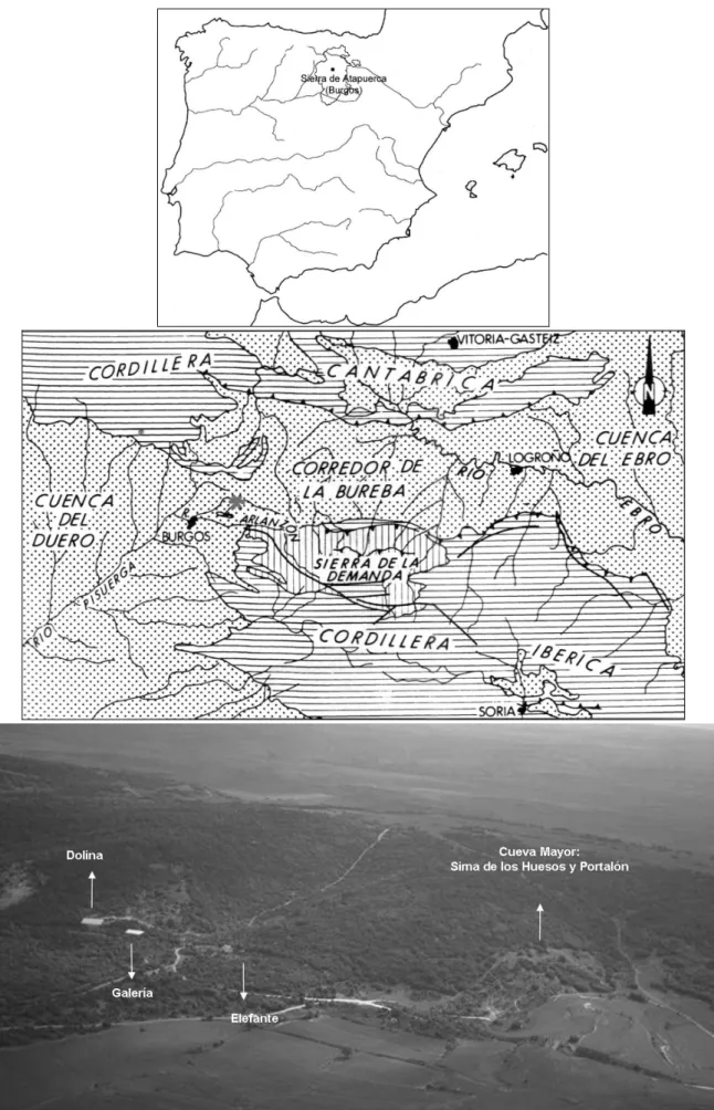
INTRODUCTION AND HISTORICAL FRAME The Sierra de Atapuerca is located about 15 km to the east of the city of Burgos, on the northeastern edge of the Northern Sub-plateau of the Iberian Penninsula. This geographic location is strategic. The north-south lines of communication that penetrate toward the interior of the Penninsula pass through it, along with those that develop east-west communicating with the basin of the rivers Duero and Ebro.
This sierra encloses an important karst in which the Cueva Mayor-Cueva de Silo cave systems standout (Martín Merino et al. 1981). Its entrance is a large chamber known as the “Portalón of Cueva Mayor” where there has been different occupations throughout its recent prehistory (Fig. 1.1).
The first scientific study of Cueva Mayor carried out in the last third of the 18th century (Sampayo and Zuaznávar, 1868), motivated the visit of other researchers who delivered news of the first archaeological remains of the recent prehistory of Portalón (Carballo, 1910), as well as the existence of diverse panels of post-paleolithic art (Breuil, 1913).
In 1966, Francisco Jordá, professor at the University of Salamanca, carried out the first archaeological excavation
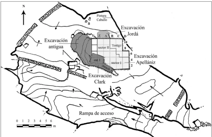
of Portalón, but his results were never published. In 1972, Geoffrey Clark, a researcher at the University of Arizona, interested in surveying the Upper Paleolithic sites of the Northern Plateau, made two test pits in Portalón; one 2x2 m that yielded altered sediments to a depth of 2 m, and another of 0.5x2 m that revealed an in situ stratigraphy 2.6 m deep (Clark 1979, 94-95; Fig. 1.2). Clark identified three cultural periods in the stratigraphic sequence, attribu-ting the first three levels (1-3) to the Roman period; levels 8 to 20 to different stages of the Bronze Age and levels 21 to 26 to phases of the Neolithic (Clark 1979, 96).
The interesting cultural sequence detected by G. Clark motivated Juan María Apellániz, professor at the University of Deusto, to get involved in Portalón with the to a better understanding of occupations of those that he designated as “population of the caverns” in prehistory (Apellániz, 1983) (Fig. 1.2). The excavation between 1972 and 1983, permitted Apellániz to define a series of cultural levels verifying the presence of medieval and late roman materials (levels I and II), and an important occupation during the Bronze Age (Level III). This level was in turn subdivided into a stratigraphic sequence of the Final Bronze Age dated to between 940 and 1220 ±130 B.C. (Minguez 2004, 50), a rich Middle Bronze Age sequence with chronologies of 1450±50 B.C., and a Late Bronze Age squence dated to 1690 ± 50 B.C. (Apellániz and Domingo 1987, 263).
A.I.ORTEGA ET AL.:THE PORTALÓN AT CUEVA MAYOR (SIERRA DE ATAPUERCA,SPAIN): A NEW ARCHAEOLOGICAL SEQUENCE
Fig. 1.2. Scaled plan of the Portalón de Cueva Mayor site indicating the different excavations areas
RECENT EXCAVATION OF PORTALÓN (2000-2006)
With the goal to a better understanding of the archaeological potential of Portalón we began a new stage of excavations in 2000 within the Proyecto de Investigación de Atapuerca directed by Juan Luis Arsuaga.
Once we delimited the in situ excavation areas of F. Jordá, G. Clark and J.M. Apellániz, we detected the presence of an important excavation in the central part of Portalón, whose authors are currently unknown (Fig. 1.2). From 2001 onward we concentrated all our efforts in delimiting the in situ limits of the site. In order to achieve this, we proceeded to excavate the sediments that filled this earlier excavation, among which we have recovered interesting archaeological material from disturbed contexts (Juez 2005). This intervention consisted of a ditch inclined in an east-west direction of some 2 m in width that gives ways to a hole with an oval cross-section of 2 m in diameter and that, for the moment, has more than 9 m in depth since we still haven’t excavated all. Judging by characteristic of this pit we believe it to be a mining intervention.
However, the excavation of the pit has revealed a deep and interesting stratigraphic sequence that was unknown until now.
STRATIGRAPHIC SEQUENCE AND ABSOLUTE CHRONOLOGY
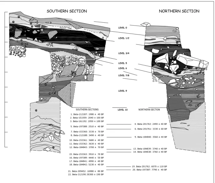
With the current obtained data we have characterized the stratigraphic sequence of Portalón in the North and South profiles and we have divided it into 11 numbered levels from 0 to 10 (Fig. 1.3). The radiocarbonic datings (Beta Analytic INC) obtained for the levels of the Portalón sequence are given in Table 1.1.
Tab. 1.1. Radionarbonic datings of the Portalón de Cueva Mayor.
Level 0: corresponds to an irregular alteration of the first
15 to 68 cm of the roof of the sequence and composed of a packet by brown muds with organic materials, charcoals, faunal remains and potter's wheel ceramics. It is a partially altered level without absolute dates and with ceramic materials pertaining to the Middle Ages.
Level 1: an ashy layer with disperse charcoals that
alternate with dark grey clays forming aggregates, with small limestone klasts, with a maximum thickness of 40 cm. A roman occupation was registered with common ceramics and Terra Sigillata of late-roman and Imperial typologies. There are three radiometric dates for this level: 1980 ± 40 BP, 2040 ± 100 BP and 2050 ± 100 BP.
4. Beta-201763: 2490 ± 40 BP 14. Beta-184838: 3760 ± 40 BP 13. Beta-184839: 3740 ± 40 BP 9. Beta-184840: 3560 ± 40 BP 6. Beta-201761: 3330 ± 60 BP 20. Beta-197387: 7790 ± 40 BP 19. Beta-201762: 6070 ± 110 BP 2. Beta-153359: 2040 ± 100 BP 3. Beta-161192: 2050 ± 100 BP 7. Beta-153360: 3330 ± 70 BP 5. Beta-197388: 2510 ± 40 BP 8. Beta-212188: 3490 ± 40 BP 10. Beta-153361: 3680 ± 40 BP 11. Beta-153362: 3630 ± 40 BP 15. Beta-153363: 3910 ± 70 BP 12. Beta-184843: 3700 ± 70 BP 17. Beta-184841: 4990 ± 40 BP 18. Beta-184842: 5230 ± 40 BP 21. Beta-209452: 16980 ± 80 BP 16. Beta-197389: 4440 ± 50 BP 1. Beta-212187: 1980 ± 40 BP 22. Beta-212190:30300 ± 190 BP 15 12 16 17 18 21 22 LEVEL 0 LEVEL 1/2 LEVEL 3/4 LEVEL 5 LEVEL 6 LEVEL 7/8 LEVEL 9 LEVEL 10
SOUTHERN SECTIONS NORTHERN SECTION
SOUTHERN SECTION NORTHERN SECTION
14 13 9 6 4 1 8 10 11 7 5 2 3 19 20
Fig. 1.3. Sratigrafical sequence of the northern and southern profiles from Portalón de Cueva Mayor site indicating the different excavations areas
Level 2: consists of some sediments of anthropic and
organic origins where they alter marks with abundant ash and clayey muds of dark tones (7.5YR 7.1), reaching a maximum depth of 30 cm. Hand made ceramics corresponding to the cultural phase of Iron Age I have been recovered in this level, as well as the remains of domestic fauna. In the north profile it is not clear the subdivision between levels 1 and 2. There are two dates for this level, one of 2510 ± 40 BP and the other of 2490 ± 40 BP.
Level 3: consists of a thin collection of dark colored
sandy-clayey-muds, of some 16 cm in thickness, where there is plenty organic material with numerous charcoals remains and elements of material cultural, documenting fragments of hand-made ceramic pertaining to the protocogotas cultural phase and abundant faunal remains. The absolute chronology puts this level in the Middle Bronze Age, with two dates of 3330 ± 60/70 BP.
Level 4: deep homogeneous packet, of
sandy-clayey-muds, of between 70 and 150 cm in thickness, increasing its depth toward the interior of Cueva Mayor. This level is rich in organic and charcoal material, emphasized by the presence of numerous klasts and big limestone blocks originating from the collapse of the walls and roofs of the cavity. Abundant hand-made ceramic fragments are documented in its profiles, as well as pieces of lithic and bone industry, together with the faunal remains. We place the chronology of this level in the Early Bronze Age with four dates that go from 3490 ± 40 BP to 3680 ± 40 BP.
Level 5: level of sandy-clayey-muds of grayish tones
(10YR 6/1), with abundant charcoals and ashes in its base. The average depth is of some 35 cm, where there are abundant fragments of handmade ceramics and domestic faunal remains. They show typical dates of the transition of the old Bronze Age to the
A.I.ORTEGA ET AL.:THE PORTALÓN AT CUEVA MAYOR (SIERRA DE ATAPUERCA,SPAIN): A NEW ARCHAEOLOGICAL SEQUENCE
Chalcolithic that goes from 3630 ± 40 BP and 3760 ± 40 BP. The intervention of Apellániz culminates in this level, documenting a fragment of bell beaker ceramic.
Level 6: level of sandy-clayey-muds of anthropic origin,
with abundant organic material and charcoals that have a grayish color. Towards its base, lenses of ash are documented. It presents an average thickness of 30-35 cm. The presence of ceramic and faunal remains are also documented in this level, presenting a date pertaining to the Chalcolithic (3910 ± 70 BP). The intervention of Clark concludes in this unit.
Level 7/8: stand out for their stoney and anthropic
attributes, consisting of angular limestone rocks and subangulars rocks without matrix that increase in size with depth. In the base of this level big limestone blocks appear, among which stand out two flat stones of some 70 cm in height by 50 and 65 cm in width respectively. This level presents the form of a tumulus that reaches a maximum height of 200 cm in the Southern Profile, while diminishing in size toward the north. In this structure a relatively abundant amount of human remains are documented, as well as ceramic and faunal fragments. The remains of a large vessel with decorations of pellets, a copper awl and the presence of two goats in anatomical position over the two large flat stones stand out, and have been given a chronology of 4440 ± 50 BP. All this indicates the sepulchral use of this cavity during periods of the chalcolithic.
Level 9: is made up of the final part of the Holocene
sequence, composed of a very homogenous packet with anthropic origins, characterized by clayey-sandy-mud sediments with blackish tones, with abundant organic material and rich in charcoals. In this unit sub-angular limestone stones and small calcareous blocks are observed, together with some round stones of quartzite. It has an average depth of 125 cm in its southern profile that increases toward the north at 170 cm. In the base of this large layer the presence of a silo structure is documented with a depth of about 75-80 cm and a diameter of 130 cm that has in turn affected the lower levels (N9a and N10). The documented archaeological record indicates the presence of handmade ceramic fragments and faunal remains, as well as lithic and bone industries. However there is a need to distinguish two very different chronological moments within this level. The superior part of this level is dated at 4990 ± 40 BP, the upper middle level at 5230± 40 BP and the base at 7790 ± 40 BP. An awl of clearly neolithic typology recovered in the northern profile stands out between the elements of material culture and has a chronology of 6070 ± 110 BP. As we see, these dates indicate an occupation situated fully within the Neolithic and another during the Mesolithic period, with a temporal hiatus of 1720 years between both occupations. We
still have not detected any remains of ceramics during the visual analysis of the base of level 9 (mesolithic occupation).
Level 9a: a small level of bat guano of between 5 and 8
cm of thickness characterized by sterile muddy-sand sediment for the moment, without absolute dates. It represents the transition between the two documented sedimentary units in Portalón de Cueva Mayor, the superior holocene (N0 a N9) and the inferior pleistocene (N10).
Level 10: This level represents the inferior sedimentary
unit that has been in turn divided into 12 numbered sub-levels from P1 to P12. It is characterized by an alternation of angular limestone clasts of more than 1 cm originating from debris flow, containing a muddy-sandy-clay matrix of brownish and orangish tones, inserted between levels of fine sediments which show a near absence of clasts. It presents a visual depth of more than 360 cm, and is abundant in microfaunal remains of cold environments along with a small amount of macrofauna. Small flakes of flint (BP2G) were recovered in the P8 sub-levels. Level 10 belong to the Upper Pleistocene with a date of 16.980 ± 80 BP for the P1 sub-level (around 60 cm of the contact with N9a) and another of 30.300 ± 190 BP for the sub-level P11 (around 335 cm of the same contact).
INTERPRETATION OF THE SEQUENCE OF PORTALON AT CUEVA MAYOR
The archaeological sequence of Portalon has been described in this paper. We can conclude that as the Portalon of Cueva Mayor has been used like habitat place during a long and intense period of time, the stratigraphic sedimentation is continuous and homogenous. Therefore, the correct interpretation of the different occupation levels is very difficult.
The stratigraphic sequence of Portalón presents two principle sedimentary units. The lower unit, identified as N10, has a visible depth of 360 cm, and is characterized by debris flow of clasts with clayey matrix of orangish color, with absence of organic material and with hardly any human intervention. Chronologically it pertains to the last third of the Late Pleistocene and stands out for its paleontological nature and for a weak presence of human activity between 30.000 and 17.000 BP. In the future we may be able to investigate the human settlement of the Plateau during the beginning of the Late Paleolithic.
Above this lower unit, a very clear contact made up of a level of bat guano (N9a), lies the upper unit, with a maximum depth of 630 cm and comprises levels 9 to 0. It is characterized by sedimentary homogeneity and grayish coloring with an abundance of organic material and numerous archaeological remains indicative of highly anthropic levels. In the complete sequence the presence of
stones and blocks coming from the roof of the chamber is frequent, being of greater size in the upper unit.
The cultural sequence of this unit indicates the existence of an intense human occupation throughout the Holocene. This occupation began with still very poorly known phases of the Mesolithic and Neolithic (N9). We hardly know the characteristics of these occupations that must have involved nomadic populations in which livestock and agriculture probably complemented the hunting. The chronological results might be related with those of the sites of the immediate surroundings like Galeria del Sílex (Cueva Mayor), Abrigo del Mirador, (also in Sierra de Atapuerca), with the Cascajos (Quintanadueñas) nearby settlement, with Abrigo de Mendandia (Saseta-Treviño) site, Cueva de la Vaquera (Segovia) and Cueva Lóbrega (La Rioja).
The Neolithic sequence culminates in a tumulus structure with funerary characteristics associated with megalithism at the end of the Neolithic and with the Chacolithic world (N8-7), evidenced in Atapuerca and Rubena villages (both in Sierra de Atapuerca).
The continuous sequence of the Bronze Age levels (N6 a N3) represent the best understood moment due to continuous excavation works. The great diversity and quantity of elements of cultural material indicate the importance of the activities developed by the human groups that controlled the surrounding territory. There are several excavated cavities within the Sierra karst complex: Galería del Sílex, Abrigo Mirador and Cueva Ciega at Ibeas de Juarros and Cueva de la Revilla at Atapuerca, are the most outstanding.
Finally, the archaeological sequence completes with the phase of occupation of the proto-historic (N2) and historic epoch (N1 and N0), when the cavity was utilized as sheepfold in order to hold the livestock. This human occupation might be related with the nearby Tritium Autrigonum castrum (Monasterio de Rodilla) and the Roman villae from the Atapuerca village.
CONCLUSIONS
The current archaeological sequence from the Portalón at Cueva Mayor takes on a singular importance due to the scarcity of information on the late Upper Pleisto- cene, Mesolithic and Neolithic cultural periods in the interior Peninsula and, in particular, in the Northern sub-plateau.
In the Portalón sequence two main sedimentary sequences can be detected. The first one (the lower unit) is correlated with the Upper Pleistocene, which has a very important paleontological record, and a weak human activity presence placed between 30.000 and 17.000 B.P. The second one (the upper unit) is correlated with the Holocene and is characterized by anthropic evidences.
This unit can be divided in two phases, one of them related to the Recent Prehistory, with a continuous settlement in the Mesolithic and Neolithic. It is remarkable the sepulcral character developed during the end of the Neolithic and Chalcolitic, which intensified the Bronze Age occupation. The second cultural phase of Portalón is interpreted as a low use of stable during Proto-historic and Historic periods.
Acknowledgements
We are very grateful to our colleagues and friends from the UCM-ISCIII Research center, LEH of the University of Burgos. Thanks also to Marta Negro curator of Museo de Burgos for providing permission and helpful access to the materials collections in their care. Special thanks go to Ciarán Brewster and Nuria García for their kind revision of the English. This research was supported by the Ministerio de Ciencia y Tecnología, Proyecto nº BOS2003-08938-C03-01. Funding for the field work came from the Junta de Castilla y León and Fundación Atapuerca. Help in the field from the Grupo Espeleológico Edelweiss is essential. Thanks also to excavation Team of Portalón and other Atapuerca sites.
Bibliography
APELLÁNIZ, J.M.; MARCOS, J.L.; DOMINGO, S. (1983): “Informe sobre planteamiento, desarrollo, problemas y futuro del yacimiento arqueológico de “Cueva Mayor de Atapuerca” (Ibeas de Juarros, Burgos)”. Diputación Provincial de Burgos. Inédito. APELLÁNIZ, J.M.; DOMINGO, S. (1987): Estudios
sobre Atapuerca (Burgos). II Los materiales de superficie del Santuario de la Galería del Sílex.
Cuadernos de Arqueología de Deusto. Bilbao.
BREUIL, H.; OBERMAIER, H. (1913): “Travaux executés en 1912” L’Anthropologie. 24: 5-7.
CARBALLO, J. (1910): “De Espeleología. Recientes descubrimientos prehistóricos y geológicos. Pruebas experimentales de la duración de las pinturas. Glíptica en las cavernas. ¿Astronomía prehistórica?”. Boletín
de la Real Sociedad Española de Historia Natural, 10:
468-481.
CLARK, G. (1979): The North Burgos Archaelogical Survey. An inventory of cultural remains. In The North Burgos Archaelogical Survey: Bronze and Iron Age archaeology on the Meseta del Norte (Province of Burgos, North-Central Spain). In Anthropological
Research Papers, 19. Arizona State University. Dept.
of Antropology, Arizona.
JUEZ, L (2005): Estudio tipológico y contextualización de los materiales cerámicos recuperados en la campaña del año 2000 en el yacimiento del Portalón de Cueva Mayor (Sierra de Atapuerca, Burgos).
A.I.ORTEGA ET AL.:THE PORTALÓN AT CUEVA MAYOR (SIERRA DE ATAPUERCA,SPAIN): A NEW ARCHAEOLOGICAL SEQUENCE
MARTÍN, M.A. [et. al.] (1981): Estudio de las cavidades de la Zona BU-IV-A (Sierra de Atapuerca). KAITE,
Estudios de Espeleología Burgalesa, 2, 41-76.
MÍNGUEZ, M. (2005): “Estudios sobre Atapuerca (Burgos): III. Los materiales del Bronce Final de «El Portalón de Cueva Mayor»”. Cuadernos de
arqueología, 20. Excma. diputación de Burgos y
Universidad de Deusto.
ORTEGA, A.I., CARRETERO, J.M., JUEZ, L., GARCÍA, R., GÓMEZ, A., RODRÍGUEZ, L.,
SANTOS, E., PÉREZ, R., ORTEGA, M.C., GUTIÉRREZ-AVELLANISA, A., RUÍZ, M.B., DORADO, M., VALDEOLMILLOS, A., PÉREZ-GONZÁLEZ, A.Y ARSUAGA, J.L. (2004): “Yacimiento del Portalón de Cueva Mayor: revisión de un yacimiento en Cueva”, en IV Congreso de
Arqueología Peninsular. Programa y libro de resúmenes, 67. Universidad do Algarve, Faro.
SAMPAYO, P.Y ZUAZNAVAR, M. (1868): Descripción
TORCA L’ARROYU: A NEW HOLOCENE SITE IN THE CENTRE
OF ASTURIAS (NORTH OF SPAIN)
Rogelio Estrada GARCÍA
1, Jesús F. JORDÁ PARDO
2, Joan S. MESTRES TORRES
3and
José Yravedra Sainz de los TERREROS
21 Arqueólogo Consultor. C/ Río Esva, 7, 1ºA. E-22010 Oviedo (Spain) · rogelio.estrada@teleline.es
2 Laboratorio de Estudios Paleolíticos. Departamento de Prehistoria y Arqueología. Facultad de Geografía e Historia. Universidad Nacional de Educación a Distancia. C/ Senda del Rey, 7. E-28040 Madrid (Spain) · jjorda@geo.uned.es 3 Laboratori de Datació per Radiocarboni. Facultat de Química, 3ª planta. Universitat de Barcelona. C/ Martí i Franqués,
1. E-08028 Barcelona (Spain) · js.mestres@ubu.edu
Abstract: The archaeological site of Torca L’Arroyu was discovered in 2002 during the works of construction of the new net of sewer
of Llanera’s municipality (province of Asturias, N of Spain). The archaeological deposit is placed inside a small cave and it has provided some ceramic fragments very rolled, two polished lithic pieces, abundant bones of animals consumed by the man and charcoals. The archaeological materials and the 14C dates of the bones associated with the ceramics (UBAR-803 4930 ± 70 BP y UBAR-804 4240 ± 60 BP) indicate the existence of an settlement of certain duration that would correspond to the chronological frame of the regional Neolithic. Sites of this chronology are very scanty in the Cantabrian area, therefore, this new deposit will contribute to a better knowledge of the Neolithic in this zone of the Iberian Peninsula.
Key words: geoarchaelogy, radiocarbon, taphonomy, pottery, polish stone, Neolithic, Holocene, Asturias
Résumé: Le gisement holocène de Torca l’Arroyu a été découvert dans 2002 durant les oeuvres de réalisation du réseau
d’assainissement de la municipalité de Llanera (Asturias, N de l’Espagne). Le dépôt, situé à l’intérieur d’une petite grotte, a proportionné nombreux fragments céramiques très roulés, deux pièces de pierre polie, nombreux restes osseux d’animaux consommés par l’homme et fragments charbonneux. Les matériels archéologiques et les dates 14C des os associés aux céramiques
(UBAR-803 4930+70 BP y UBAR-804 4240+60 BP) nous indiquent l’existence d’un lieu d’occupation de certaine durée que l’on peut attribuer au cadre chronologique du Néolithique régional. Les gisements de cette chronologie sont très peu abondants dans la corniche cantabrique, donc, ce nouveau gisement contribuera à une meilleure connaissance du Néolithique dans cette zone de la Péninsule Ibérique.
Mots clé: geoaarchéologie, radiocarbone, taphonomie, céramique, pierre polie, Néolithique, Holocene, Asturias
INTRODUCTION
The site of Torca l’Arroyu is located in the centre of the province of Asturias (UTM: X=270.400, Y=4.810.797, Z=170), in the vicinity of Oviedo (village of La Ponte, parish of Cayés, Council of Llanera) (figure 2.1.A). Its discovery was fortuitous, since it appeared during the works of construction of the new net of sewer of Llanera municipality, in December of 2001. After its find, the construction company stopped the works and asked for the professional services of R.E.G to carry out the archaeological documents of the find. There were previous proceedings to obtain the excavation permit from the Culture Board of the Principado de Asturias. A scanty but interesting collection of ceramic rests stands out among the recuperated materials. There are two polished lithic pieces, a high number of bone rests that belong to macromammals and scanty gastropods.
GEOARCHAEOLOGY: THE CAVITY AND ITS FILLING
The cavity of Torca l’Arroyu is located in the west side of the mesozoical deformed materials of the Oviedo trough in the mesotertiary basin of Asturias. They form the cover of the western extreme of the Central Area of la Cantabric Range (Barnolas y Pujalte, 2004). It is opened in the
limestones and marls of the Upper Cretaceous (Cenoma-nian) which is placed in agreement over the conglome-rates, sands and clays of the Albian (IGME, 1973). They appear a few metres below following the slope. At this point, the Cretaceous serie is inclined towards NE with a direction close to N45ºE and a dip of 19º/22º NE. They form the western flank of syncline of Llanera in the NW extreme of the synclinorium of Oviedo-Infiesto.
Geomorphologicaly, the area of Torca l’Arroyu belongs to the morphological division called Longitudinal Depression (Martínez, 1981), it is also called Prelitoral Trough or Intermediate Depression (Martín-Serrano, 1994), which agrees partialy with the unit of relief of the Mesozoical-Tertiary cover (Farias y Marquínez, 1995), units of relief that belongs to the coastal-mesozoical cantabric border, which is located in the NE extreme of the Meridional Hesperian Massif. In this area, the river Nora runs confined within the Cretaceous materials mentioned. It runs from E to W after running through the detritic materials of the Terciary of the Basin of Oviedo; then, the river gets into the Carboniferous limestones of the Naranco hill, more towards the W. Torca l’Arroyu is located in the slope of the right side of the Nora river, which runs among 140 and 150 m. level. The slope ends up in a small plain belonging to the rests of a applanation surface subsequent to the Paleogene, because the river links with the higher levels of the deposit of that
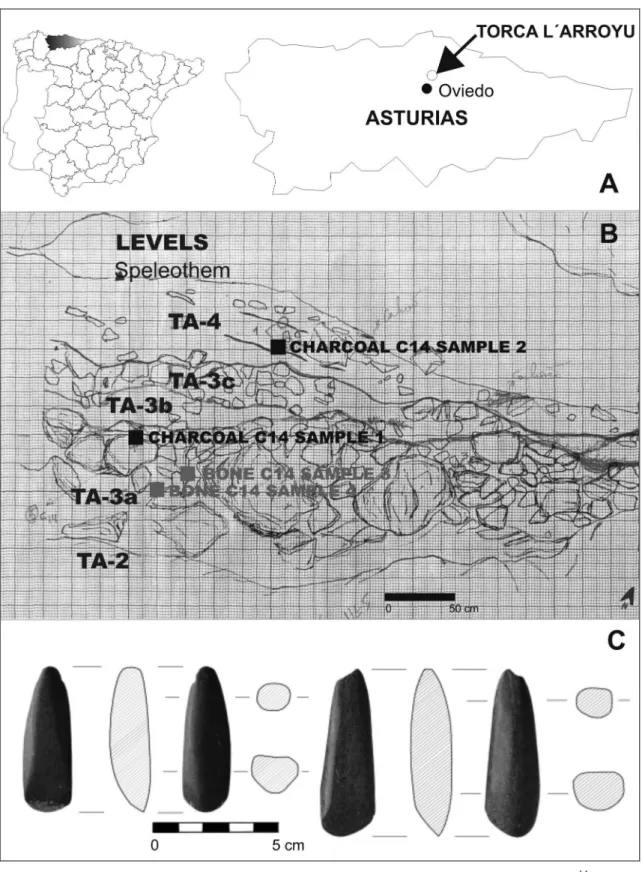
Fig. 2.1. A: Geographical location of Torca l’Arroyu. B: Stratigraphical scheme with indication of 14C samples. C: Polished lithic materials of Torca l’Arroyu
chronology belonging to the Tertiary Basin of Oviedo, and, it is previous to the confinement of the Quaternary fluvial net.
The made gap cut partialy a karstic cavity partialy filled. It is expanded in an alternation of sandy limestones and
marls where the first ones prevail. They appear into banks of tabular geometry of metric and high power. We do not have the cenital extreme of the cave. It was wiped out by the construction works on the slope where it was discovered. The access to the outside would be probably in the missing area. The opening would be blinded and
R.E.GARCÍA ET AL.:TORCA L’ARROYU:A NEW HOLOCENE SITE IN THE CENTRE OF ASTURIAS (NORTH OF SPAIN)
would be a collapse sinkhole (torca) where the partial filling took place through a deposit formed by a cone of thick and thin detritic materials crowned by a speleotheme. The different stratigraphic sections that can be seen in the gap have allowed to obtain a complete lithostatigraphic sequence from the deposit affected by the works. The base of the sequence lays on the limestones and marls mentioned, which are karstified with an irregular pre-depositonal surface where a threshold area stands out. It is situated, aproximately, in the vertical of the disappeared cenital entrance. This ledge determines the geometry of the deposit; so that two sediment areas can be distinguished. In one of them, the material transport shows a NE direction, and in the other, a S direction. This one is worse controlled due to record disappearance. From wall to ceiling the sequence is composed of the following lithostratigraphic units (figure 2.1.B):
−Unit TA-1: 40 visible cm of clays and yellow sandy marls with small stones of authoctonous lime rounded by alteration (centil: 1 cm), with a high content in carbonates, with irregular geometry, they fill the karstic palaeotopography of the cavity soil. Sterile.
−Unit TA-2: 8-10 cm of dark brown clays with stones of authoctonous lime rounded by alteration (centil: 1 cm), they are very scanty and with a low content in carbonates. It contains scanty rests of mammals and gastropods together with fragments of carbonized organic matter. Its contact is net with the previous materials and its geometry is lenticular, it is getting lost toward the proximal extreme of the deposit. It presents a strong depositional inclination towards NE, it is shaped by the paleotopography of the cavity.
−Unit TA-3. It is composed of three subunits or levels from wall to ceiling:
oSubunit TA-3a: 60cm – 1 m (in the W profile) of clast-supported conglomerate formed by blocks and pebbles of authoctonous lime (centil 1 m) It’s lower contact is net and its geometry is lenticular. It is getting thin towards the proximal extreme of the deposit, it shows a marked depositional dip towards NE. Two lithic polished tools, decorated ceramic fragments and bone rests (sampled for C14) come from those deposits.
oSubunit TA-3b: 30 cm (in N profile) of brown clays, very plastic, scanty carbonated, with lenticular geometry (maximun lateral extension: 2 m) and inclined arrangement similar to the previous level. They contain many fragments of carbonized organic matter, some bone rests and some specimens of gastropods non-troglophilus. Samples of some charcoals were taken for its radiocarbonic date.
oSubunit TA-3c: 30-40 cm of clast-supported conglo-merate with scanty matrix, more plentiful at the base. It is formed by boulders and pebbles of authoctonous lime, angular (centil: 30 cm), which include frag-ments of speleothemes that have come off the ceiling
of the cavity , and limy plaquets of 30 cm of maximal dimension and 4 cm of thickness. Both, towards the proximate extreme and towards the distant one, this subunit joints the TA-3a, so that the big clayish lentil remains in the centre. It contains rests of carbonized organic matter and bone rests.
−Unit TA-4: 50-75 cm of very dark brown clays that are arranged parallely to the previous subunit. It has a well marked limit due to the lithological difference; however, a discontinuity in the sediment process cannot be seen. This unit shows some internal arrangement outlined by two levels of black organic matter and by the arrangement of authoctonous lime plaquets (centil: 30 cm). They are slightly overlapped parallely to the depositional surface, which is configurated by some levels with a certain order. Both levels present a remarkable lateral continuity, so that they can be seen in the different cuts. Its depositional inclination is towards NE, the same that is outlined by the alignment of plaquets. They contain bone rests, specimens of non-troglophilus gastropods and fragments of undecorated ceramic.
−Unit TA- 5: 2-10 cm of stalagmite cover that embraces rounded pebbles (centil: 20 cm) and seals the whole detitric deposit that lays below; as a result, there is an inclined crust towards the inside of the cavity with direction N-NE on the surface. It contains non-troglofilus gastropods and bone rests.
THE RECUPERATED MATERIALS Polished lithic materials
The only recuperated lithic materials (unit TA-3a) are two polished lithic pieces (figure 2.1.C) of a small size made out of amphibolite (length: 69,53 mm and 62,07; mesial width: 19,79 mm and 18,94 mm; mesial thickness: 16,30 mm and 16,02 mm). They present a trapezoidal form that tends to a triangular and lengthened one; a thick profile, a rectangular rounded oval section and a curved thick edge with a very marked asymmetric profile, both pieces are shaped by a bevel (Eiroa et al., 1999). The polishing of the bevel belonging to the bigger piece matches with the one of the ventral side of the piece. It does not show a marked wearing due to use. On the contrary, the bevel of the smaller one shows an oval surface produced by the wearing due to use. It presents a slight inflection with the polishing of its ventral side; besides, it can be appreciated a wearing on its edge, which is also marked by an inflection on the surface of the bevel. There is a concave wearing, lengthened in its back area, which is produced by friction with a cylindrical object. Its heels are pyramidal with a rounded vertex and do not shows percussion marks; the heel of the smaller piece has two lateral notches that are perpendicular to the longitudinal axis (figure 2.1.C.1), probably, related to the handling system, while the one of the bigger piece is affected by a small fracture with a loss of lithic material (figure
R.E.GARCÍA ET AL.:TORCA L’ARROYU:A NEW HOLOCENE SITE IN THE CENTRE OF ASTURIAS (NORTH OF SPAIN)
2.1.C.2). In relation to their typology, both pieces present the usual characteristics of the chisels (Eiroa et al., 1999), tools used to carve the wood nicely. From our point of view, its more correct denomination would be firmer chisel, because these ones are used to carve wood while the chisels are used to work the stone and the metal. Both lack of percussion prints on the heels, so that they might have been used with handle. This would be proved by the notches that the smaller one has on the heel. Besides, this piece evidences clear signs of use because two types of wearing on its bevel can be appreciated. The bigger one does not show notches on the heel, which is partially fractured, nor clear prints of use, since the ventral and bevel surfaces seems to belong to the making process.
Pottery
The ceramic materials of Torca L’Arroyu form a small collection that is composed of an amount of 68 fragments. All of them are handmade, 61 of them were recuperated in the unit TA-3, five fragments, in the unit TA-4, and two fragments, in the mixture of the gap. The materials of the unit TA-4 are: three fragments of wall of small size and reducing baking, and two fragments of wall of mixed baking and thin degreasing. One of them has its edges rolled, while the other shows a smoothed surface. A more attractive view is presented by the ceramics remains of the unit TA- 3. The following ones stand out among them (figure 2.2.A):
1. Three decorated fragments which form a very thin piece (figure 2.2.A.1), slighty rolled, concave in its longitudinal profile and convexe in the transverse one. It is characterized by the presence of two rounded rims or borders. One of them parallel to the longitudinal axis, and other that is normal to this. This one is slighty thickened. It is a ceramic piece made, apparently, on a thin plate that was probably leaned against an irregular surface (ground), since it shows a smoothed side, the decorated one, and other one quite irregular. Maybe, it was just the wish of finishing finely the decorated side, and for that, it was smoothed when the piece was already made and the paste was still soft. Its morphology appeals: the rim forms a 90º angle, which could be a fragment of handle. The degreasing is thick (> 2mm) and mainly, limy. The baking is oxidizing, its inside is reducing. The decoration consists of two lines of discontinuous incisive strokes in the thickened side of the edge, from them, five lines go at right angles: the two first, which come from the second rim, are formed again by discontinuous incisive strokes; secondly, there are three continuous incisive lines. The composition concludes with two lines of discontinuous incisive strokes; therefore, the decorative structure of the preserved fragment is completely symmetrical. If we consider that the undecorated ceramic fragment, the one that shows some of carbonated concretion, is a handle, then, we can think that the same decorative pattern could be repeated in the missing part.
2. This is a fragment that, as it happens with the previous piece, presents two orthogonal rims with a longitudinal profile, slightly concave and transversal convexe. It shows superficial carbonate concretions. It is hardly rolled (figure 2.2.A.2). It shows a main rim slightly thickened with a flat lip which turns suddenly, leaving an angle inferior to 90º in this case; and gets the same thickness than the rest of the piece. Now, the lip appears rounded. It presents a mixed baking with colouration changes, mainly among light greys and pale oranges. Both, the internal and external surfaces seem smoothed and the thickness changes reveal again slow rotations during its making. Here, the degreasing is also limy and it may include small vegetable fibres.
3. Fragment of wall of carenated ceramic. The inflection is appreciated both, in the internal and the external side of the piece (figure 2.2.A.3). It has been made with a slow rotation (handmade ceramic), where changes of thickness are very frequent in the same horizontal line. The baking is mixed. It is mainly oxidizing in the superior side of the careening and reducing in the inferior one. The paste is quite decanted and the degreasing is almost imperceptible at first sight. It presents limy concretions in the external side mainly. The edges are not rolled and it presents superficial carbonated concretions.
4. Rolled ceramic (fragment of wall) with an external inflection marked by a horizontal careen (figure 2.2.A.4). The baking and the degreasing are identical to those of the piece number 1, as well as the decoration, which is based on small strokes of burin. They form four parallel lines to the careen, and tend to horizontality together with the rests of to prints which are perpendicular to these. The external side, as it happens with the piece of number 1, has a more careful finish than the internal one, which has many irregularities. It belongs to the usual name of handmade ceramic, which can be named again as ceramics made with slow rotations. All this seems to indicate that this fragment and the one of the number 1 belonged to the same piece.
5. Four bottom fragments (see description 8) (figures 2.2.A.5, 2.2.A.6, 2.2.A.7 and 2.2.A.8): The base of the pieces is flat. The thickness of the bottom is out of proportion as regards the thickness of the start of the preserved wall. They seem to be made by slow rotation. Instead of using sticks/bars of paste, it seems that a very liquid paste has been applied using the fingers, and lately, it has been smoothed with the hands or with a spatula. There are areas in the external side where the smoothing is not homogeneous; therefore, layers of clay that were previously applied can be seen. The baking is mixed: the external side of the piece tends to be oxidizing while the internal side is reducing. There are several sizes of degreasing. It presents rests of soot in the external side, so that it can be inferred an use to cook food by putting the piece
directly beside the fireplace. One of the pieces (figure 2.2.A.7) has some very remarkable changes of thickness considering the small size of the preserved fragment. Its degreasing is limy, scanty but it has a big size (fragments of 3-4 mm). These four fragments present a bad condition. Two of them stand out because of its marked rolling
The differences in the baking do not show different moments, since, in this kind of batches made in mono-chamber ovens (holes in the ground where the pots are put and covered with firewood), the baking of each pot changes a lot according to the place they are inside the oven, and also, if the pieces are in close contact to the combustion. The degreasings, mainly limy, could show that the place where the earthenware was taken is quite near the settlement. Considering the described materials and their secondary position within the same level, this small ceramic collection does not allow us to do great chronocultural appraisals. However, two ceramic groups can be distinguished in a first approach. There is a first lot of several fragments which contains the two mentioned rims and the decorated fragments, which we associate to Neolithic. The second one is a small group that includes the carenated fragment, which could belong to a more advanced period, possibly to Copper Age.
Faunal remains
The malacological rests are scanty and come from subunit TA-3a and subunit TA-4. This group is only composed of gastropods. A specimen of Palella (Patella) vulgata (Linné, 1758), recuperated in TA-3a, stands out. The rest of the group belongs to three different kinds of continental gastropods that were found in the two mentioned units.
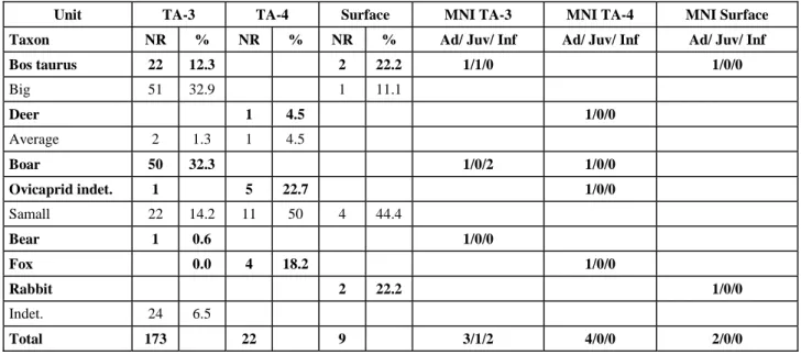
With regards to macromammals, the zooarchaeological analysis of the group shows the following spectrum of species: Bos taurus, Ovis aries or Capra hircus among the domesticated ones, and Sus scropha, Orictolagus
cuniculus, Cervus elaphus, Ursus arctos and Vulpes vulpes among the wild ones. The lot of bones is composed
of 203 rests; the ones of unit TA-3 stand out among them because they are the more numerous group (table 2.2). Compared to unit TA-3, unit TA-4 is no representative; it can be stood out the lack of animals of big size and the presence of rests of some kind of ovicaprid.
The bones of Torca l’Arroyu presents a very well preserved fauna. It has only turned out to be representative the fauna belonging to unit TA-3, since unit TA-4 contains few rests. The boar stands out among the documented animals; with regard to the domestic ones, the presence of the cow stands out. The presence of the ovicaprids is testimonial and little meaningful. The taphonomic and seasonal data allow to claim that the boars were hunted during summertime and the beginning of winter. In the case of the rest of the animals, the lack of seasonal data does not allow us to know when they died;
but the taphonomic information indicates, as it occurs with the boar, that the different animals of units TA-3 and TA-4 were processed by the human being, except for the fox, which lacks of cutting marks and its rests are not fragmented. Despite we can explain the represented fauna and its consequences to the human being, the existence of other alterations indicates that we face a group slanted by different processes. The presence of rolled and polished bones in unit TA-3 evidences that we are before a bone group moved by hydric transport. In the same way, the scavenger action of carnivores suggests that they acted on the bone sample slanting it. Therefore, we can think that these two agents could slant the bone sample and, at the same time, they can be also the main responsible ones of the high trampling that the bone rests show. The real importance of the fauna of Torca L’Arroyu is based on the presence of domestic fauna in a precise moment of the Asturian Neolithic and also, because of the predominance of the boar among the wild species.
GEOCHRONOLOGY: RADIOCARBONIC DATES In order to obtain numeric ages for the site of Torca L’Arroyu, we sent five samples of charcoal and bone material coming from two different archaeological levels, TA-3 and TA-4 to the Laboratory of Radiocarbonic Date of the University of Barcelona, finally, they got reduced to four samples (figure 2.1.B).
Table 2.1 shows the source unit of the samples, the material, the code of laboratory, the date assignation results expressed in BP1(1) with its uncertainty belonging
to once the usual deviation of the radiometric measures that we indicate ordered from minor to major age. It also shows the results of the dates calibration according to CalPal 2005 SFCP curve (Weniger et al., 2005). The probability intervals are indicated, whose sum is equal to 95,4% (calibration 2 sigma) (Stuiver y Reimer 1993 ), expressed in calendaric years cal. BP and cal. BC/AD2.
TORCA L´ARROYU: NEOLITHIC SETTLEMENT, FIRES AND SEDIMENT PROCESSES
Considering the information exposed before, the first to be distinguished, on studying the sediment filling of Torca l’Arroyu, is that although it is a site located in a secondary position, it contains a very interesting geoarchaeologic information that we will try to decode
1 BP (before present). It is used to indicate a radiocarbonic date
expressed in its own chronological scale, which comes from the year 1950 dC. It is always presented through two values: the experimental value and the usual deviation belonging to the group of the radiometric measures. (Mestres, 2000a, 2000b).
2 Cal BC (before Christ). It is used to indicate a date in the sun
chronologic scale; it is expressed in years before Christ. It comes from the calibration of a radiocarbonic date.
Cal AD (annus Domini). It is used to indicate a calibrated date that comes from a radiocarbonic date. It is expressed in sun years after Christ.
R.E.GARCÍA ET AL.:TORCA L’ARROYU:A NEW HOLOCENE SITE IN THE CENTRE OF ASTURIAS (NORTH OF SPAIN)
Tab. 2.1. Torca L’Arroyu. Taxonomic profiles according to NR and MNI
Unit TA-3 TA-4 Surface MNI TA-3 MNI TA-4 MNI Surface
Taxon NR % NR % NR % Ad/ Juv/ Inf Ad/ Juv/ Inf Ad/ Juv/ Inf
Bos taurus 22 12.3 2 22.2 1/1/0 1/0/0 Big 51 32.9 1 11.1 Deer 1 4.5 1/0/0 Average 2 1.3 1 4.5 Boar 50 32.3 1/0/2 1/0/0 Ovicaprid indet. 1 5 22.7 1/0/0 Samall 22 14.2 11 50 4 44.4 Bear 1 0.6 1/0/0 Fox 0.0 4 18.2 1/0/0 Rabbit 2 22.2 1/0/0 Indet. 24 6.5 Total 173 22 9 3/1/2 4/0/0 2/0/0
NR: Number of remains; MNI: Minimal number of individuals; Ad.: Adult; Juv: Juvenile; Inf.: Infantile
Tab. 2.2. Torca L´Arroyu. Calibrated Radiocarbonic Dates
Unidat Material Code 14C dates BP 2 σ calibrated dates
cal. BP (0=AD1950)
2 σ calibrated dates
cal. BC/AD
TA-4 Charcoals UBAR-746 2050 ± 120 2340 – 1740 cal. BP 390 cal. BC – 210 cal. AD
TA-3b Charcoals UBAR-745 3190 ± 150 3790 – 3030 cal. BP 1840 – 1080 cal. BC
TA-3ª Bones indet. UBAR-804 4240 ± 60 4940 – 4580 cal. BP 2990 – 2630 cal. BC
TA-3ª Bones of Bos taurus UBAR-803 4930 ± 70 5850 – 5530 cal. BP 3900 – 3580 cal. BC
along this work. The hypothetical geodynamic model that we lay out considers the previous existence of an open air site located in the slope where the sinkhole opens. It is in a topographic position superior to the sinkhole. In this way, the slope and the small hill where the slope ends up offer excellent conditions for the habitat, with a South orientation and with a good sight control over the near fluvial bed of the Nora river. The chronology of this occupation of surface is marked by the date UBAR-803 4930 ± 70 BP (5850-5530 cal. BP), obtained from bone rests of an only specimen of Bos taurus. It locates the settlement in the first half of IV millenium a.c. (3900-3580 cal. BC) (figure 2.2.B). The length of this occupation would be defined by the date obtained from a sample that contains several bones, UBAR-804 4240 ± 60 BP (4940- 4580 cal. BP) (figure 2.2.B), so that its result would be the mean of its different ages; it would show us an average chronology for the settlement, which would go along the first third of the III milenium B.C. (2990-2630 cal. BC). If we sum the probabilities of both dates, the period of validity for the settlement would be in the interval 5860-4610 cal. BP (3910-2660 cal. BC), whose considered duration is 1250 years. This long duration of the inhabitation of the slope settlement together with the
presence of ceramic materials that seem to belong to two different moments would be showing us the existence of two moments of inhabitation: one of them would belong to the Neolithic, associated to the date UBAR-803, which the decorated ceramics would come from, and the other one, to the Copper Age, associated to the date UBAR-804, the carenated ceramics belong to it. The first moment would be related to the Neolithic levels of some other Asturian sites such as the A2 level of the Cave of Mazaculos (González Morales, 1995) whose date is GAK-15221 5050 ± 120 BP (6040-5560 cal. BC) or the tumulus MAXII of Monte Areo (de Blas, 1999) whose date is CSIC-1380 5133 ± 30 BP (6000-5720 cal. BP; 4050-3770 cal. BC) (figure 2.2.B).
Inside the cavity, the sequence begins with some materials which are produced by the rock alteration of the substratum (unit TA-1). They fill in the existing paleotopography in the cavity ground and probably, were placed in a time when the cavity was without outside communication. The sequence continues when the conection of the cavity with the outside is made through a small collapse sinkhole which contains external mate-rials.
After leaving the settlement of the slope, some of its rests and the thin geologic materials from the surface went through processes linked to a dynamic of gravity-slope with hydric influence due to rainfalls of some intensity. This produced clay layers, which are the source of unit TA-2.
Later, there was a fire in the slope and the vegetation was wiped out. As a consequence, the archaeological rests that were still there and the surface geological materials (thin and thick) went through a new sediment cycle by processes of gravity-slope with hydric influence, which are the source of the clay layers with pebbles and blocks that ended up in subunit TA-3a, whose inside contains a lot of archaeological materials (bone and ceramic rests, polished tools) and clear signs of hydric transport. The presence of big angular blocks of authoctonous lime in the base of TA-3a evidences that in those moments, there were collapses in the opening of the torca, which enlarged its original size. The sediment process of gravity-slope continues with the clay layer of subunit TA-3b dated in the interval 3790-3030 cal. BP (1840-1080 cal. BC), which has scanty lateral extension in the sediment cone, and with the clay layer with stones and blocks of subunit TA-3c, which superimposes on subunit TA-3a towards the distal areas of the cone. Both, TA-3b and TA-3c contain scattered and scanty archaeological rests, which evidences that the rests of the settlement of the slope surface were practically dismantled.
Later, the slope where the settlement was located went through another fire which wiped out its vegetal cover; besides, new episodes of dragging by gravity-slope processes took place and led to the sediment process of unit TA-4 dated in the interval 2340-1740 cal. BP (390 cal. BC-210 cal. AD), where two levels of well stratified ashes and charcoals can be seen in the clay sediments.
Finally, during a wet epoch with mild temperatures of some duration, the precipitation of the calcic carbonate took place. It formed the espeleotheme which sealed the deposits of the sinkhole. The precipitation continued over it, and stalagmites and stalactites were produced; in some cases they have formed small columns.
Bibliography
BARNOLAS, A.; PUJALTE, V. (eds.) (2004) La Cordillera Pirenaica. In: VERA, J.A. ed., Geología de
España. Madrid: Sociedad Geológica de España –
Instituto Geológico y Minero de España, p. 231-343. BLAS CORTINA, M.A. (1999) Nuevas formas tumulares
neolíticas en el Monte Areo. Excavaciones de 1995 a 1997. Excavaciones Arqueológicas en Asturias
1995-1998. Oviedo: Principado de Asturias. p. 101-110.
EIROA, J.J.; BACHILLER GIL, J.A.; CASTRO PÉREZ, L.; LOMBA MAURANDI, J. (1999) Nociones de
tecnología y tipología en Prehistoria. Barcelona:
Editorial Ariel S.A. 393 p.
FARIAS, P.; MARQUÍNEZ, J. (1995) El relieve. In: ARAMBURU, C.; BASTIDA, F., eds., Geología de
Asturias. Gijón: Ediciones Trea. p.163-172.
GONZÁLEZ MORALES, M.R. (1995) Memoria de los trabajos de limpieza y toma de muestras en los yacimientos de las cuevas de Mazaculos y el Espinoso (La Franca, Ribadedeva) y la Llana (Andrín, Llanes) en 1993. Excavaciones Arqueológicas en Asturias
1991-1994. Oviedo: Principado de Asturias. p. 65-78. MAPA GEOLÓGICO DE ESPAÑA E. 1:50.000, nº 29
(13-4) Oviedo. Madrid: Instituto Geológico y Minero
de España, 1973.
MARTÍN-SERRANO, A. (1994) Macizo Hespérico Septentrional. In GUTIÉRREZ ELORZA, M., ed.,
Geomorfología de España. Madrid: Editorial Rueda,
p. 25-62.
MARTÍNEZ GARCÍA, E. (1981) La geología y el relieve de Asturias. Enciclopedia Temática de Asturias. Gijón: Silverio Cañada, Ed., t.10, p. 57-124.
STUIVER, M.; REIMER,P.(1993) Extended Data Base and Revised CALIB 3.0 14C Age Calibration Program.
Radiocarbon, 19 (1), p. 215-230.
STUIVER, M. [et al] (1998) INTCAL98 Radiocarbon Age Calibration 24,000-0 cal. BP. Radiocarbon, 40 (3), p.1041-1084.
WENINGER, B.; JÖRIS, O.; DANZEGLOCKE, U. (2005) Glacial radiocarbon age conversion. Cologne
radiocarbon calibration and palaeoclimate research package <CALPAL> User manual. Köln: Universität
zu Köln, Institut für Ur- und Frühgeschichte, Rdio-carbon Laboratory, 29 p.
FROM “INLAND NEOLITHIC” TO “NEOLITHIC DWELLING IN THE
INLAND”: THE ROLE OF HOMOGENEOUS AND HETEROGENEOUS
ELEMENTS ON THE EXPLANATION OF EARLIER AGRICULTURAL
STAGES IN CENTRAL SPAIN
Enrique CERRILLO CUENCA
Instituto de Arqueología – Mérida. Plaza de España, 15. 06800 Mérida (Badajoz). Spain. E-mail: ecerrillo@iam.csic.es
Abstract: In early eighties, some Spanish archaeologists started to use the concept “inland Neolithic” to make reference to those
rare sites with impressed vessels located in the inland areas of Iberia. This expression has been regularly used by those archaeologists who needed to name the archaeological findings as a new reality which differs from Neolithic coastal groups. But in fact, the notion of “inland Neolithic” can be found in some writings of 1930’s and 1940’s by Bosch Gimpera and San Valero, who had proposed other concepts such as “Caves with decorated potteries Culture” and “Neolithic of the Plateau” to name it. Since that moment, the neolithic sites of several provinces of Spain and Portugal were supposed to be more recent than the caves sited near the shorelines of Spanish Levant and Andalusia, introducing an axiom that would no be easily forgotten.
Nowadays, some projects developed in inland Iberia have shown an intense Neolithic dwelling alongside the basin of Duero, Tagus and Guadiana rivers, in the spaces considered as being part of the former “Inland Neolithic”.
Maybe, the “Inland Neolithic” concept was defined within a theoretical framework dominated by the lack of archaeological data, but, at the present time, its validity can be questioned by the large number of existing sites. In this paper I wish to discuss some concepts involved in the use of this expression rather than make a synthesis about the recent research in those territories. I think that many related concepts must be reviewed; especially those linked to the homogeneity of some cultural aspects and even what can and what can not be considered as “inland”.
The homogeneous/inhomogeneous nature of Neolithic groups from the inland is analyzed in order to understand the process of neolithization: whether or not the origin of Neolithic in the Inland is the same in all territories (i.e. as result of a wide colonization), and even it is a useful way to “measure” the implication of “indigenous” components on the formation of agricultural landscapes.
Summing-up, I believe that is time to look for specific regional studies and understand the diversity of geographical environments in order to appreciate the emergence of agricultural practices in inland Iberia.
Key-Words: Iberia Inland Neolithic; Neolithization process; Agricultural landscapes
Resumo: No início da década de 80, alguns arqueólogos espanhóis utilizaram o conceito “Neolítico Interior” para classificar
alguns, raros, sítios com cerâmicas impressas, localizados no interior do espaço peninsular, e que se diferenciavam dos grupos neolíticos conhecidos nas regiões costeiras.
No entanto, o conceito “Neolítico Interior” pode ser já encontrado na bibliografia produzida, nas décadas de 30 e 40, por Bosch Gimpera e San Valero, que propuseram os termos “Cultura de grutas com cerâmicas decoradas” e “Neolítico da Meseta” para designar essas realidades. Desde então, considerou-se que os sítios neolíticos de diferentes regiões de Espanha e Portugal, seriam mais recentes que a ocupação das grutas localizadas no litoral levantino e na Andaluzia, introduzindo no debate um axioma de difícil contestação.
Neste momento, alguns projectos a decorrer no interior da Península Ibérica, demonstraram a existência de uma intensa ocupação neolítica ao longo das bacias do Douro, do Tejo e do Guadiana, portanto nas áreas tradicionalmente integradas no “Neolítico Interior”.
Este conceito construído num quadro teórico marcado pela escassez de informação arqueológica pode, hoje, ser discutido em função do importante número de sítios já detectados. Neste trabalho, discutem-se alguns conceitos associados a esta designação que necessitam de urgente revisão, designadamente os que admitem a homogeneidade de alguns aspectos culturais e os que rodeiam os conceitos de “interior.”
A homogeneidade/heterogeneidade dos grupos neolíticos do Interior é analisada tendo em vista o processo de neolitização; a origem comum, ou distinta, deste Neolítico do Interior (em consequência de um processo de colonização); a participação e o contributo das realidades indígenas na formação das paisagens agrícolas.
Em suma, este parece o momento para desenvolver análises regionais e analisar o papel da diversidade de ambientes geográficos no quadro da emergência das práticas agrícolas no interior peninsular.
Palavras-chave: Neolítico Interior; Processo de Neolitização; Paisagens Agrícolas
In 1980, M.D. Fernández-Posse published her work about the excavations of El Aire’s cave at Patones (Madrid). She stated that many of decorated sherds, manly with impressed and incised motives, could be related to some cultural context from Andalusia, where the research on Neolithic had a strong tradition on the study of pottery. In fact, this archaeologist proposed that some sites with
impressed pottery in Central Spain would be related to a same cultural group defined apparently by its poor archaeological documentation (Fernández-Posse 1980). She used the “inland Neolithic” expression to make reference to those dispersal sites in Northern and Southern Plateau which shared the common attribute of impressed vessels. In that moment, a new cultural concept
Fig. 3.1. Location of some Early Neolithic sites cited in text
was born, and it would have a frequent presence in Spanish archaeological literature during the eighties and nineties decades.
Nevertheless “Inland Neolithic” is not really an original concept by itself, some ideas can be found in early writings about the Iberian Neolithic. Since the 1930’s and 1940’s decade Bosch Gimpera (1945) and San Valero (1946) had been working in the cultural delimitation of Iberian Neolithic groups on the territory. P. Bosch Gimpera (1945) distinguished four groups in Neolithic Iberia. Among them, the “Central Culture” or “Caves with Decorated Pottery Culture” is the one that involves a significant part of inner Iberia. J. San Valero (1946) stated that there were five Neolithic groups in Iberia; among them, the “Plateau (Meseta) Neolithic” can be understood as a primary definition of “Inland Neolithic”.
The study of “Inland Neolithic” and its cultural systemi-zation was the aim of two brief works published by Antona (1986) and Municio (1988) in the eighties, both
authors gather data from inner Neolithic sites and try to explain the human presence in Central Iberia during Neolithic. The same expression has been used by Portuguese scholars to refer the sites located far from the Atlantic shore, in the inner lands of Portugal. Despite the historiographical origin of this expression is neatly different from Spain, the same procedure seems to be implied in its use. In fact, the archaeological knowledge and documentation of Neolithic realities in inner lands of Tagus, Douro and Guadiana basins is clearly posterior to the first data about Early Neolithic at diverse lands.
In both cases, there is an underlying question that has been reinforced by later interpretations of the neolithiza-tion process: the spread of agriculture and livestock breeding towards inner lands of Iberia would be produced as the result of a demic colonization of unhabited territories. Several Spanish (Kunst & Rojo 1999) or Portuguese (Zilhão 2003) archaeologist have supported this hypothesis taking into account the lack of Mesolithic records in Central Spain, and even the existing delay