(Annals of the Brazilian Academy of Sciences) ISSN 0001-3765
www.scielo.br/aabc
Fluoride characterization by principal component analysis in the hydrochemical
facies of Serra Geral Aquifer System in Southern Brazil
ARTHUR NANNI1, ARI ROISENBERG2, JANDYRA M.G. FACHEL3, GILBERTO MESQUITA4 and CRISTIANO DANIELI5
1Departamento de Geoquímica, Instituto de Geociências, UFRGS, Av. Bento Gonçalves, 9.500, prédio 43126/105
91501-970 Porto Alegre, RS, Brasil
2Departamento de Geoquímica, Instituto de Geociências, UFRGS, Av. Bento Gonçalves, 9.500, prédio 43126/103
91501-970 Porto Alegre, RS, Brasil
3Departamento de Estatística, Instituto de Matemática, UFRGS, Av. Bento Gonçalves 9.500
91501-970 Porto Alegre, RS, Brasil
4Núcleo de Assessoria Estatística, Instituto de Matemática, UFRGS, Av. Bento Gonçalves 9.500
91501-970 Porto Alegre, RS, Brasil
5Instituto de Geociências, UFRGS, Av. Bento Gonçalves, 9.500, prédio 43126/105, 91501-970 Porto Alegre, RS, Brasil
Manuscript received on May 7, 2007; accepted for publication on May 14, 2008; presented byALCIDESN. SIAL
ABSTRACT
Principal component analysis is applied to 309 groundwater chemical data information from wells in the Serra Geral Aquifer System. Correlations among seven hydrochemical parameters are statistically examined. A four-component model is suggested and explains 81% of total variance. Component 1 represents calcium-magnesium bicarbonated groundwaters with long time of residence. Component 2 represents sulfated and chlorinated calcium and sodium groundwaters; Component 3 represents sodium bicarbonated groundwaters; and Component 4 is characterized by sodium sulfated with high fluoride facies. The components’ spatial distribution shows high fluoride concentration along analyzed tectonic fault system and aligned on northeast direction in other areas, suggesting other hydrogeological fault systems. High fluoride concentration increases according to groundwater pumping depth. The Principal Com-ponent Analysis reveals features of the groundwater mixture and individualizes water facies. In this scenery, it can be determined hydrogeological blocks associated with tectonic fault system here introduced.
Key words:fractured aquifer, geostatistics, GIS, groundwater, hydrogeology.
INTRODUCTION
Water scarcity and increasing human consumption re-quires new sources of water with adequate potability. Therefore, an emergent necessity to understand ground-water resources is evident. Low cost treatment and tech-nical advances in exploration turns groundwater into a vital and precious natural resource.
Fluoride content in water, like other chemical spe-cies, is beneficial to human health but can be toxic when
Correspondence to: Dr. Arthur Nanni E-mail: arthur.nanni@gmail.com
anthro-to a natural origin, such as prolonged water-rock inter-actions (Nordstrom et al. 1989). The drinking water limit recommended by the World Health Organization for fluoride is 1.5 mg/L (WHO 2002), and in a moderate concentration (0.7-1.2 mg/L) prevents dental cavities.
The main aim of the current study is to understand the distribution of high-fluoride waters in the Serra Geral Aquifer System (SGAS) and to identify the hydrochemi-cal types and their spatial distribution, using the Principal Component Analysis (PCA). PCA is an important tool for understanding the large quantity of data involved in extended aquifer studies (Invernizzi and Oliveira 2004). This aids to define geological sources and pathways for high fluoride, consequently, assisting future well loca-tions and management of SGAS waters. Investigaloca-tions about the source of high fluoride concentrations in previous studies had shown a relationship with tectonic structures and with pumping of deep groundwater.
GEOLOGY AND HYDROGEOLOGY OF THE STUDY AREA
The study area is located in the Rio Grande do Sul State, southern Brazil and extends from 27◦S to 31◦S and
from 50◦W to 57◦W, corresponding approximately to
164.207 km2in the Parana Basin. The region is covered
by a basaltic to rhyolitic Mesozoic volcanic sequence belonging to the Serra Geral Formation (SGF), whose thickness varies from 50 to 1000 meters (average of 550 meters), constituting a fractured aquifer that provides public water supply to more than 80% of the cities in the area.
SGAS hydrochemical characteristics indicate the influence of water mixing with other sedimentary aquifer belonging to the Parana Basin (Szikszay et al. 1981, Fraga 1992, Portela Filho et al. 2002, 2004). This aquifer is directly superimposed by the Guarany Aquifer System/GAS (Campos 2000) that has been the focus of several studies in the last few years, due to its spatial extent and storage potentiality as a transnational aquifer. Tectonic structures cut the SGF controlling terrain surface and hydrochemical characteristics of the related aquifer. These structures are connected to the South Atlantic Ocean opening, causing NE and NW dominant directions (Fig. 1). The main fault systems define sectors
The tectonic block limited by the Terra de Areia-Posadas Fault System and Mata-Jaguari Fault System is uplifted in the south-central area. The adjacent block to the north shows a gradual terrain lowering from east to west, con-ditioned by NE normal faults, parallel to the Leao and Perimpo fault systems.
The identification of different water facies for SGAS focused on tectonic block separations is important to define structures where high fluoride groundwater can ascend from deep levels to SGAS. This tectonic control for the high fluoride groundwaters has been reported in other regions (Licht 2001). In the study area the SGAS fluoride average concentrations are around 0.24 mg/L, with a minimum value of 0.02 mg/L, and the highest at 3.03 mg/L. Machado (2005) describes the influence of Ca2+HCO−
3 meteoric recharge on the SGAS and mixture
mechanisms between the SGAS and the GAS inputing Na+HCO−
3 with SO24−and Cl−water to SGAS.
MATERIALS AND METHODS
HYDROCHEMICALDATA
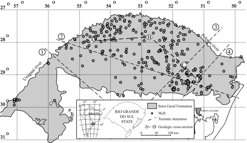
Hydrogeological data represent a network of 309 deep wells (Fig. 1) that exposes only SGAS groundwater used in public and private water supply. All data informa-tion was provided by governmental groundwater man-agement agencies.
This study regarded only seven major parameters to evaluate hydrochemical facies in the piper diagram, namely fluoride, Na+
, Ca 2+ , Mg 2+ , HCO −
3, SO
2−
4
and Cl−.
STATISTICALANALYSIS
Fig. 1 – Location map of SGAS(gray) in Rio Grande do Sul State, sampling wells and main tectonic fault systems: (1) Mata-Jaguari, (2) Terra de Areia-Posadas, (3) Perimpo, and (4) Leao.
SPATIALANALYSIS
Spatial distribution and interpretation of principal com-ponents defined by PCA was performed on Geograph-ical Information System (GIS) with Quantum GIS ver-sion 0.7.4 software (Sherman et al. 2005). Cluster results were classified, considering the most important chemical parameter as an identification name.
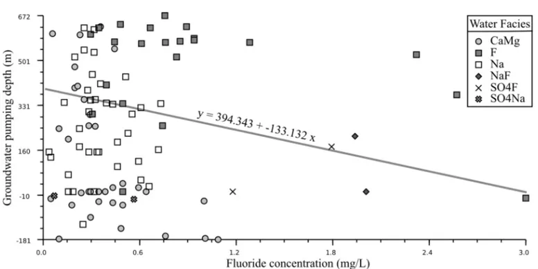
The relationship between depth and fluoride con-centration considers the maximum absolute groundwater pumping depth in each well. This procedure was carried out with Labplot version 1.5 software (Gerlach 2004) in order to investigate whether fluoride concentration in SGAS increases with depth.
RESULTS AND DISCUSSIONS
PRINCIPALCOMPONENTANALYSIS
Table I presents the correlation coefficient matrix for hydrochemical data in SGAS.
The solution using the eigenvalue criterion results in four components that explain 81% of the total variance. Component 4 is highly weighted by fluoride (Table II).
Component 1 is mainly influenced by HCO−
3,
Ca2+, and Mg2+, and explains 37.43% of the total
vari-ance, representing calcium-magnesium bicarbonate groundwaters with long residence time, evidenced by Mg2+. Component 2 is defined by SO2−
4 and Cl−, and
represents sulfated and chlorinated, calcium and sodium groundwaters.
Component 3 is explained by HCO−
3 and Na+,
defining sodium bicarbonated groundwaters.
Component 4 is defined by F, followed by Na+
and SO2−
4 , corresponds to sodium sulfate with high
flu-oride facies.
Fluoride participates with similar intensity on Components 2 and 3, suggesting two groundwater sources that contain relatively high fluoride concentra-tion. Therefore, fluoride was associated with sulfated and sodium bicarbonated groundwaters.
Parameter Na+ Mg2+ Ca2+ Cl− SO2−
4 HCO−3 F− Na+ 1.0 0.0069 –0.043 0.235 0.263 0.46 0.339
Mg2+ 1.0 0.549 0.351 0.093 0.457 0.096
Ca2+ 1.0 0.273 0.207 0.4 –0.012
Cl− 1.0 0.457 0.352 0.198
SO2−
4 1.0 0.196 0.385
HCO−
3 1.0 0.094
F− 1.0
TABLE II
Rotated matrix with four components and characteristic parameters.
Parameters Components
1 2 3 4
Mg2+ .874 .063 .072 .139
Ca2+
. 811 . 231 –.045 –.043
Na+ –.143 .188
. 870 .271 Cl− .353 . 707 . 206 –.051 HCO−
3 . 572 .095 . 699 –.091 SO2−
4 .030 . 872 .074 .237
F− .067 .145 .150
.956 Explained variance 37.433 20.260 12.694 10.770 Cumulative % of variance 37.433 57.693 70.386 81.156
The cluster interpretation was based on final center scores. Thus, each cluster was renamed using related ion predominance (Table III). In order to facilitate the read-ing it was decided to designate Component 1 asCaMg,
Component 2 asSO4, Component 3 asNa, and
Compo-nent 4 asF.
It can be defined that clusters 3 and 4 are com-posed predominantly by F component groundwaters.
Clusters 1 and 7 comprise theCaMgwater facies.
Clus-ter 8 is composed by Na component. The remaining
groups show more than one component in high concen-tration.
In the water facies, components SO4, Na, and F
were added to the main water facies. Therefore, these clusters were called SO4Na, SO4F, and NaF, due to
their final centroid intensities. This components com-bination is a result of the interference of different geo-chemical water sources and/or mixture features.
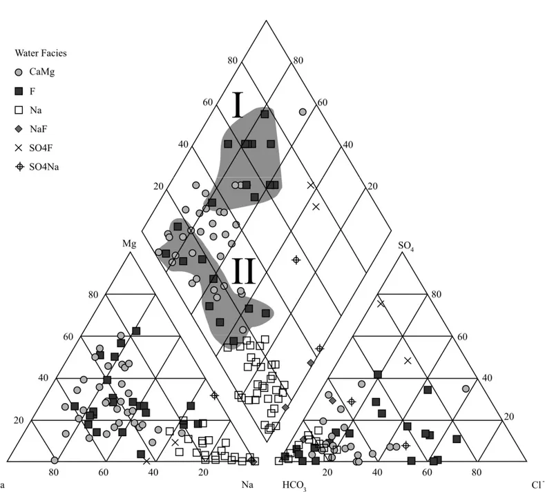
HYDROCHEMISTRY
The geochemical data were plotted in a piper diagram (Fig. 2), with the four renamed cluster defined by the PCA. The majority of wells (212 out of 309 wells) have a composition related to meteoric waters with
Ca2+HCO−
3 nature and do not include high fluoride
waters. In this case, 212 samples are not represented in the diagrams, in order to obtain a better fit by the other groups.
TheCaMgfacies represents a predominant HCO−3
water type where Mg+2 appears in more than 50% of
the wells (Fig. 2).
The Na group shows their typical distribution in
the piper diagram, representing Na+HCO−
3 waters. Fdistribution in the piper diagram maintains an
TABLE III
Components final cluster centers and clusters name reclassification.
Component Cluster
1 2 3 4 5 6 7 8 9
CaMg 1.6143 –0.6137 –0.228 0.511 –0.152 –0.724 2.042 –0.722 –1.720 SO4 0.987 4.411 –0.377 –1.198 –0.113 9.303 –0.236 –0.260 –0.348 Na –0.892 3.032 –0.881 –0.667 –0.305 –0.845 1.092 1.653 2.691
F –0.330 –1.357 1.244 6.986 –0.250 2.849 0.285 –0.034 4.786
Cases 22 2 19 3 212 2 11 36 2
Water Facies CaMg SO4Na F F Meteoric SO4F CaMg Na NaF
different groundwater sources or point out to mixture features during groundwater ascending recharge.
SO4Na, SO4F, and NaF facies appear only in
two wells each. Both wells compose distinct groups as showed in Figure 2.
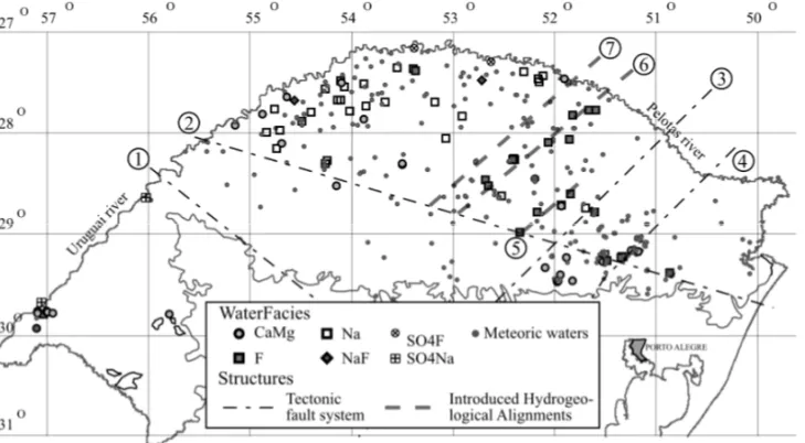
The spatial distribution of water facies confirms that fluoride has a relationship with the analyzed fault sys-tems Mata-Jaguari, Terra de Areia-Posadas, Perimpo, and Leao (Fig. 3).
Meteoric Waters occurs in all SGAS, but more
significantly in the tectonic block limited by Terra de Areia-Posadas, Jaguari-Mata and Perimpo Fault Sys-tems, due to the uplift condition of this block.
The CaMgfacies is spatially related to discharge
zones of SGAS in the west, northwest, and southeast regions, representing waters at the final percolation stage under long time residence.
TheNafacies is dominant in the northwest region, where SGF achieves the maximum thickness in the study area, suggesting a hydrogeological tectonic block. This characteristic indicates that ascendant waters in this re-gion present only Na+enrichment, as a result of
water-rock interaction in SGF. Thus, the non-interference of GAS in this scenery is evident, probably due to the maximum thickness of SGF.
SO4Nafacies appears only in the northeast
align-ment direction of the Uruguay River, showing a close relationship to this regional alignment. SO4F facies
presents a similar behavior, but occurs only in the east-west section of the Uruguay River.
NaFfacies is spatially linked to the Na
hydrogeo-logical block which has a poor fluoride content. TheNaF
with high fluoride appears only in two wells at a similar distance from the Uruguay River, suggesting a particular
hydrogeological condition.
TheFgroup related that high fluoride groundwaters
are distributed in the central-northeast portion of SGAS. Aligned wells associated with the main tectonic fault systems (Terra de Areia-Posadas, Leao and Perimpo) suggest a water ascension recharge. New tectonic fault systems are introduced in the present study, correspond-ing to the linear distribution of wells belongcorrespond-ing to F
facies in the central portion of SGAS, which receive the nomination Fontoura Xavier-Parai and Victor Graeff-Barracao hydrogeological alignments (Fig. 3). It must be stressed that the introduced structures are parallel to Leao and Perimpo Fault Systems.
The distribution ofNaFfacies is similar to theNa
facies (Fig. 3). Both are chemically very similar and distinguished by a more intensive fluoride participation in theNaFfacies.
TheSO4FandSO4Nafacies are scarce and closely associated with major regional structures that delineate the Uruguay River (Fig. 3). TheSO4Ffacies occurs in
the north sector while theSO4Nafacies occurs
prefer-entially in the west sector of the study area.
The composition of the volcanic rocks belonging to the SGF does not comprise fluorine rich minerals to provide anomalous fluoride content in the SGAS. This enrichment could be better explained by the ascending groundwater recharge crossing older Parana Basin sed-imentary sequences combined with long residence time and extreme confination conditions.
Fig. 2 – Water facies distribution in the Piper Diagram, showing two fluoride hydrochemical types (I – sulfated; II – bicarbonated).
The depth variation shows fluoride concentration increase according to groundwater pumping depth (Fig. 5). It can be demonstrated that beyondF facies,
all the other facies increase the fluoride content with the depth. This behavior probably is related to the influ-ence of confined GAS and the proximity of other older aquifer systems.
CONCLUSIONS
The PCA methodology was efficient to discriminate hydrochemical water facies in a collection of more than 300 wells located in the SGAS in Rio Grande do Sul State, southern Brazil, with special emphasis to the fluo-ride content. As a result a comprehensive spatial model
was achieved, using seven chemical components that validate six hydrochemical facies were distinguished in the SGAS, three of them containing substantial fluoride contents in combination with Na+and SO2−
4 . The
spa-tial distribution of these facies confirms the presence of hydrogeological blocks limited by tectonic alignments.
Two tectonic structures are apparently present in the central area, indicated by linear distribution of high fluoride groundwater wells. An aquifer system status for SGAS is reaffirmed, considering complex chemical mixtures, recharge processes and percolation through the fractured reservoir. The ascending recharge processes are considered to define ionic enrichment, especially in Na+, F−, SO2−
Fig. 3 – Water facies distribution and tectonic fault systems: (1) Mata-Jaguari, (2) Terra de Areia-Posadas, (3) Perimpo, and (4) Leao. Introduced hydrogeological alignments are (5) Fontoura Xavier-Parai, (6) Victor Graef-Barracao and (7) that indicates a tectonic block limit.
Fig. 4 – Geological cross-section showing the main tectonic structures responsable for high fluoride groundwater ascension. Modified from Machado, 2005.
The results were able to point out the influence of deeper confined aquifers on fluoride contents of the SGAS and add elements to minimize the costs for well location with better water quality.
ACKNOWLEDGMENTS
Funding for this study was provided by the Conselho Nacional de Desenvolvimento Científico e Tecnológico
(CNPq) and by the Fundação Estadual de Proteção Ambiental Henrique Luis (FEPAM) Rio Grande do Sul.
RESUMO
Fig. 5 – Relationship between fluoride concentration and groundwater pumping depth.
de quatro componentes foi utilizado por explicar 81% da va-riância total. A Componente 1 é representada por águas cálcio-magnesianas com longo tempo de residência, a Componente 2 representa águas bicarbonatadas sulfatadas e cloretadas, a Componente 3 representa águas bicarbonatadas sódicas e a Componente 4 é caracterizada por águas de fácies sódica e sulfatada com alto fluoreto. A distribuição espacial das com-ponentes mostra águas com concentrações anômalas ao longo dos sistemas tectônicos de falhas, analisados e alinhados a NE em algumas áreas, sugerindo outros sistemas de falhas hidro-geológicos. As concentrações de fluoreto aumentam de acordo com a profundidade de bombeamento das águas. A Análise de Componentes Principais revelou feições de mistura e individua-lizou diferentes fácies de águas subterrâneas. Neste cenário, é possível determinar blocos hidrogeológicos associados com os sistemas tectônicos de falhas introduzidos no presente trabalho.
Palavras-chave:aqüífero fraturado, geoestatística, SIG, águas subterrâneas, hidrogeologia.
REFERENCES
CAMPOSHCN. 2000. Modelación conceptual y matemática del Acuífero Guaraní, Cono Sur. Mapa hidrogeológico do aqüífero Guarani escala 1:250000. Acta Geol Leopold 4: 3–50.
FRAGAGC. 1992. Origem de fluoreto em águas subterrâneas
dos Sistemas Aqüíferos Botucatu e Serra Geral da Bacia do Paraná. Tese de Doutorado. Programa de Pós-Graduação
em Recursos Minerais e Hidrogeologia. Universidade de São Paulo. 178 p.
GENXUWANDGUODONGC. 2001. Fluoride distribution in water and the governing factors of environment in arid north-west China. J Arid Environ 49: 601–614.
GERLACHS. 2004. Labplot 1.5.0 – An application for plotting and analysis of 2D and 3D functions and data.
http://labplot.sourceforge.net.
INVERNIZZIAANDOLIVEIRASMB. 2004. Hydrochemical
characterization of a watershed through factor analysis. Águas Subterrâneas 18: 67–77.
KAFRI U, ARAD AANDHALICZ L. 1989. Fluorine Oc-currence in Groundwater in Israel and its significance. J Hydrol 106: 109–129.
KAISERHF. 1958. The varimax criterion for analytic rota-tioning factor analysis. Psychometrika 23: 187–200. KUMAR VV AND SAI CST, RAO PLKM AND RAO CS.
2001. Studies on the distribution of fluoride in drinking water sources in Medchal Block, Ranga Reddy District, Andhra Pradesh, India. J Fluorine Chem 55: 229–236. LICHTOAB. 2001. A geoquímica multielementar na gestão
LINNF, TANGJANDBIANJM. 2004. Geochemical envi-ronment and health problems in China. Environ Geochem Health 26: 81–88.
LISBOA NA. 1996. Fácies, estratificações hidrogeoquími-cas e seus controladores geológicos, em unidades hidro-geológicas do Sistema Aqüífero Serra Geral, na Bacia do Paraná, Rio Grande do Sul. Tese de Doutorado. Curso de Pós-Graduação em Geociências. Universidade Federal do Rio Grande do Sul. 135 p.
LISBOANA AND MENEGOTTO E. 1997. Diferenciações hidrogeoquímicas no sistema aqüífero Serra Geral no Rio Grande do Sul. In: XII SIMPÓSIOBRASILEIRO DE
RECURSOSHÍDRICOS, p. 489–496.
MACHADOJLF. 2005. Compartimentação espacial e arca-bouço hidroestratigráfico do Sistema Aqüífero Guarani no Rio Grande do Sul. Tese de Doutorado. Programa de pós-graduação em geologia – área de concentração em geologia sedimentar. Universidade do vale do rio dos Sinos. 237 p.
MOTURI WKN, TOLE MP ANDDAVIES TC. 2002. The contribution of drinking water towards dental fluorosis: a case study of Njoro Division, Nakuru District, Kenya. Environ Geochem Health 24: 123–130.
NIENJ, HULL CH, JENKINSJG, STEINBRENNER KAND
BRENTDH. 1975. Statistical package for the
socialsci-ences. 2nded. New York: 675 p.
NORDSTROM DK, BALL JW, DONAHOE RJ ANDWHIT -TEMORE D. 1989. Groundwater chemistry and water-rock interaction at Stripa. Geochim Cosmochim Acta 53: 1727–1740.
PORTELA FILHO CV, FERREIRA FJF, ROSA FILHO EF, BUCHMANNACANDROSTIROLLASP. 2002. Estudo preliminar da conexão entre os Aqüíferos Serra Geral e Guarani com base em dados aeromagnetométricos e hi-droquímicos. In: CONGRESSOBRASILEIRO DEÁGUAS
SUBTERRÂNEAS, 12. Florianópolis, SC, Brasil.
PORTELAFILHOCV, FERREIRAFJF, ROSAFILHOEFAND
ROSTIROLLASP. 2004. Compartimentação
magnética-estrutural do Sistema Aqüífero Serra Geral e sua conec-tividade com o Sistema Aqüífero Guarani na região central do arco de Ponta Grossa (Bacia do Paraná). Rev Bras Geo-cienc 3: 369–381.
SHERMANGE, SUTTONT, BLAZEKRANDLUTHMANL. 2005. Quantum GIS User Guide – Version 0.7.4 Seamus. http://qgis.sourceforge.net/docs/userguide.html.
SZIKSZAYM, TEISSEDREJM, BARNERUANDMATSUIE.
1981. Geochemical and isotopic characteristics of spring and groundwater in the state of São Paulo, Brazil. J Hydrol 54: 23–32.