108
A
N APPROACH TO THE CONTRIBUTION OF ANTHROPOGENIC ACTIONS FOR THEA
RARUAMA LAGOONAL SYSTEM(SE
B
RAZIL)
GEOMORPHOLOGICAL EVOLUTIONOLEGÁRIO NELSON AZEVEDO PEREIRA1*,MARIA ANTONIETA DA CONCEIÇÃO RODRIGUES2AND JOÃO MANUEL ALVEIRINHO DIAS3
1 Universidade do Estado do Rio de Janeiro, Programa de Pós-Graduação em Meio Ambiente, Rio de Janeiro, Brazil. 2 Universidade do Estado do Rio de Janeiro, Faculdade de Geologia, Rio de Janeiro, Brazil.
3 Universidade do Algarve, CIMA (Centro de Investigação Marinha e Ambiental), Faro, Portugal. * CORRESPONDING AUTHOR, [email protected]
Received on 15 June 2018
Received in revised form on 27 June 2018 Accepted on 28 June 2018
Editor:
MariaVirginia Alves Martins, Universidade do Estado do Rio de Janeiro, Brazil
Citation:
Pereira, O.N.A., Rodrigues, M.A.C., Alveirinho Dias, J.M., 2018. An approach to the contribution of anthropogenic actions on the Araruama lagoonal system (SE Brazil) geomorphological evolution. Journal of Sedimentary Environments, 3 (2): 108-120.
Abstract
The first studies regarding the constitution of the Araruama lagoonal system, located in the Rio de Janeiro state (SE Brazil), were carried out by Alberto Ribeiro Lamego. This author supported the thesis that it had resulted from the formation of a sand barrier (called Massambaba) due to the longitudinal transport of large quantities of sediments through coastal drift currents, and the growth of spits parallel to the shoreline. However, most recent studies largely rejected it, sustaining that the confinement of this hydric environment was the result of the growth of two sand barriers during the Pleistocene and Holocene times (120.000 to 7.000 years before present - BP) due to the sea level changes. The hypothesis that we suggest, is that both propositions are acceptable and complementary. This study aims to demonstrate that, despite the opinions on the formation of the double sand barrier, deposition of sediments by coastal drift currents at the end of the Holocene, and especially in recent chronologies, also contributed to the establishment of this lagoon system. In our opinion, the increased sediment supplies due to human
activities contributed to the formation of the inner spits and the nearby sea sandbar. Its orientation was influenced by the existence of the island of Cabo Frio, that allowed the formation of the tombolo that almost connected it to the continent. Through the analysis of historical and cartographic documents related to the colonization and economic exploitation of the region, it is evident that the anthropogenic actions played a significant role in the sandy spits formation. Of these, special emphasis is placed on the agriculture and deforestation that contributed to the increase of sedimentary accumulation. This work demonstrate that the analysis of historical documents can provide information and contribute to the understanding of recent coastal developments.
Keywords: Environmental History. Coastal environments.
Lagoonal formation. Interaction Man-Nature.
109
1 Introduction
The geomorphologic evolution of Araruama lagoonal system has been extensively debated. Indeed, for over 50 years, numerous theses about this subject were presented by different authors (Dias and Kjerfve, 2009). However, none of them had taken into account, the influence of anthropogenic actions, especially occurred after sixteenth century, as a result of the colonization by the Portuguese settlers and subsequent exploitation of land. Those circumstances certainly increased the sedimentary deposition.
The first effort to understand the geomorphologic evolution of Araruama Lagoonal system was carried out by Alberto Ribeiro Lamego (Fig. 1). This author supported the thesis that the constitution of Massambaba sand barrier, and the subsequent enclosure of the water body, was due to the longitudinal transport of large quantities of sediments through coastal drift currents, from west to east, and the growth of spits parallel to the shoreline (Lamego, 1940, 1946, 1955). However, most recent studies largely rejected this thesis. Indeed, Coe-Neto (1984) argued that the constitution of the Araruama lagoonal system had its origin on the Holocene period, when the sea level changes had concurred to the formation of the Massambaba sandy barrier during the flandrian and postflandrian transgressions.
The analysis of longshore drift measurement, had also suggested that the deposition of sediments by coastal drift currents, could not occurred has described by Lamego. The achieved conclusion was that the sediments input to the shoreline resulted from a process, which had combined frontal accretion with longshore sediment transport, and not only the second one, as described by Lamego (Muehe and Corrêa, 1989).
Turcq et al. (1999) suggested that these hydric environments were confined during two different phases, the Pleistocene and Holocene times (120,000 to 7,000 years before present - BP). During the first period, it had occurred the constitution of the landward barrier, and on the second period, the constitution of the seaward barrier. A complexity of geological events and sea level variations had contributed to it (Kjerfve et al., 1996; Turcq et al., 1999; Dias and Kjerfve, 2009).
Taking into account that the development of coastal barriers results from periods of transgressive sea levels, but also, from fluvial sediment supply and sediment accretion from the continental shelf (Dias and Kjerfve, 2009), the hypothesis that we suggest, is that the Araruama lagoonal system formation depended on both questions. Despite the opinions related to the Pleistocene and Holocene formation of the double sand barrier of Massambaba on the mentioned chronologies (120.000 to 7.000 BP), the deposition of sediments by coastal drift currents, namely in most recent chronologies along the Holocene period, also concurred to it. In our opinion, along this period, the formation of the nearby sea sandbar and the internal spits was greatly influenced by the increase of sediments input related to
human activities. The orientation of the sandbar was defined by the existence of the island of Cabo Frio, which supported the formation of the tombolo that partially connected it to the mainland.
Therefore, the purpose of this work it is to argue the possibility of human interference on the lagoonal system constitution, bringing a new contribution to the theme discussion. The study significance rests on the contribution that social sciences, namely Environmental History, can bring to this matter. As this study aims to demonstrate that the anthropogenic actions had significant influence in the constitution of the internal spits and the nearby sea sand barrier in the Araruama lagoonal system region.
2. Study Area
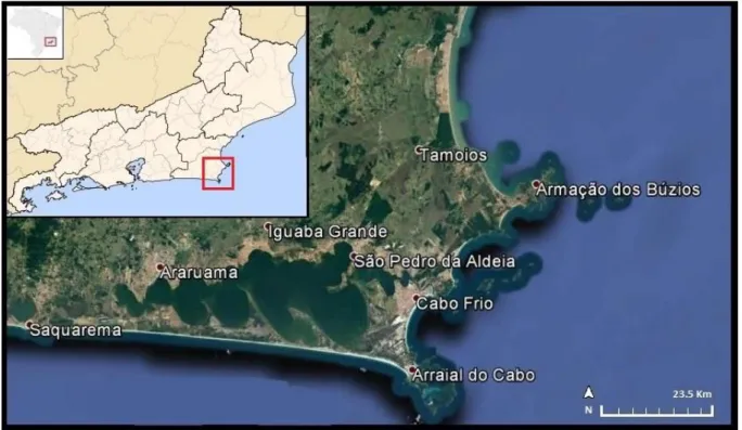
Four distinct geomorphological units constitute the Rio de Janeiro (Brazil) littoral, such as, the rocky coast, the low-lying Fluminense sedimentary plain, the beach ridge plains and the tertiary beach cliffs (Dias and Kjerfve, 2009). Located at the littoral north of Rio de Janeiro state, between the latitude 22º50’ – 22º57 S and longitude 42º00’ – 42º30’W, Araruama is the easternmost coastal lagoonal system positioned between the cities of Rio de Janeiro and Cabo Frio (Fig. 2), in an area known has region of “Baixada Litorânea”. This area is a low altitude sedimentary plain with a sequence of several lagoonal coastal systems. Araruama lagoon is one of the largest permanently hypersaline lagoons in the world, whose average salinity levels are 52% (Kjerfve et al., 1996; Muehe, 2006). With an extension of about 220 Km2 and a perimeter of approximately 160 km, it has a volume of 636 million cubic meters and estimated time of waters renewal in the order of 83.5 days (Bidegain, 2005). Its average depth is 3.2 meters, and maximum depth of 17.5 meters (Muehe, 2006). There are several reasons for the high salinity levels of this waterbody. The communication with the sea take place in the straight and shallow Itajurú channel, located on the eastern part of the lagoon, which has less than four meters deep (Lamego, 1946; Barbiére, 1975; Kjerfve et al., 1996). The climate condition of the region is semi-arid (Barbiére, 1975; Kjerfve et al., 1996; Dias and Kjerfve, 2009), with an average rainfall of approximately 800 millimetres per year (Dias and Kjerfve, 2009), a circumstance that provides different micro-climate conditions in very short distances (Barbiére, 1985), for which contributes the persistent oceanic upwelling regime, intensified by strong northeast winds (Dias and Kjerfve, 2009). The fluvial drainage to the lagoon consists on small and intermittent streams, except for two rivers - “Rio das Moças” and “Rio Mataruna” - which situates in the western of this hydric body and contribute to provide more than 50 % of its watershed (Kjerfve et al., 1996). Around the lagoonal system are established the municipalities of Saquarema, Araruama, Iguaba Grande, São Pedro da Aldeia, Cabo Frio and Arraial do Cabo (Fig. 2; Bidegain and Bizzerril, 2002).
110
Fig. 1. Geomorphological evolution of Araruama lagoonal system according to Lamego (1955). Legend: A – Initial coast and the
beginning of Massambaba sandy spit formation; B – A most advanced phase of Massambaba and the formation of Itajurú channel; C – Formation of Cabo Frio plain with the orientation of the sandy spit from south-west to northeast; D – Formation of the interior spits by internal secondary currents.
3. Materials and Methods
This study is primordially based on an analysis on the scope of Environmental History, a profoundly interdisciplinary, transdisciplinary and multidisciplinary scientific field (McNeill, 2003), which methods are often searched on other scientific areas or disciplines, because it is on permanent construction and looking for its own methodologies (Myllyntaus, 2011). Since this scientific field considers the human impacts on ecosystems, during long chronological term observations, Nature is observed as part of the conducted interpretations and treated as a Historical object (Worster, 1991; Pádua, 2002). The Environmental History studies try to understand how humans were affected throughout time by their natural environment, and how they affected that same environment, seeking to reveal the results of such interaction (Worster, 1991). This kind of observation is especially relevant, when study objects are related to maritime or coastal environments, since there are still few Environmental History analysis concerned to lagoonal ecosystems (McNeill, 2003).
With the purpose of examining the possible consequences of human actions on the formation of the double sandy spit of Massambaba several historical data were compiled. This work will be mainly based on the observation of written and cartographic historical sources, however, always taking into account data from other academic fields to support the analysis. A first effort on gathering historical data was carried out on the “Arquivo
Histórico Ultramarino” (Historical Overseas Archive – Lisbon, Portugal), and a second one was carried out on the “Arquivo Nacional” (National Archive – Rio de Janeiro, Brazil). The purpose was to collect information on documents related to Cabo Frio captaincy. The typology of considered documentation, was especially concerned to the distribution of land, firmed in “sesmarias” (contracts of property established between the Portuguese crown and the settlers to promote land exploitation). On those documents, we selected and processed data related to the exploitation of the ecosystems around the Araruama and Saquarema lagoonal systems.
Due to its potential on sediments supply to this lagoonal systems, it was given a special attention to the deforestation for the establishment of agricultural fields or wood commerce, besides the location of the exploitation areas and their vicinity to fluvial courses. It was also observed possible geomorphological landscape descriptions which could gave us information about their evolution.
Cartographic historical sources were gathered in order to consider the representation of the Massambaba sand barrier and other aspects that could support the analysis of the geomorphological evolution of Araruama lagoonal system. These cartographic data were gathered in on-line archives such as “Arquivo Nacional” (National Archive – Rio de Janeiro, Brazil), “Bibliotèque National de France” (National Library of France) and “Biblioteca Nacional” (National Library of Brazil). Besides this data, other sources were
111 observed, such as, written memories concerned to the region
and other types of descriptions about it. All the information was gathered on tables, in which was displayed the different data; therefore, it was confronted with geomorphological data from natural sciences studies and complemented with the observations upon the cartographic sources.
4.
Results
The obtained results sustain that anthropogenic actions had contributed to the constitution of the Holocene barrier near the sea and to the formation of the tombolo, which partially connects Cabo Frio Island to land. According to some historical descriptions and cartography, between the Cabo Frio Island and the continent, there existed another small island, demonstrating that by the XVI century the tombolo was not completely defined. The gathered information demonstrates that, although fluvial sediments, which were directly discharged into the Araruama lagoon, possibly had not interfere so intensely in the nearby sea sand barrier constitution, it had contributed to the formation of
the internal spits. However, the sediments input to the shoreline, through longshore transport, were an important part of the sand barrier constitution. Indeed, documentation allows us to sustain that besides the sediments provided by land exploitation around Araruama lagoon, there was also sediment supply from the “cyclic” discharges of the nearby Saquarema lagoon.
The existence of an intermittent channel, which occasionally cut-off the sandy spit and re-established the connection between the lagoon and the ocean, promoted hydric exchanges, and consequently, sediment deposition in the sea. In addition, the supply of fluvial sediments to this lagoon was intense, as evidenced by historical data. Human activities related to agriculture and deforestation along its principal fluvial suppliers have been factors that have potentiated sediment discharges at sea. Historical cartography, represents a pronounced underwater sandbank on the shore between Saquarema and Araruama lagoons, sediment supply that should be a result of the longshore transport by those intermittent re-establishments of the hydric exchanges in Saquarema.
Fig. 2. Location of the study area (adapted from the Google Earth).
5. Discussion
5.1. The Portuguese settlement at Cabo Frio and the first phase
of anthropogenic actions
Although some opinions which sustained that the first Portuguese settlement occurred on Guanabara Bay (e. g. Fernandes, 2008), other ones supports that Cabo Frio was “discovered” between December of 1503 and January of
1504, by a Portuguese fleet conducted by Gonçalo Coelho under King D. Manuel I orders (Lamego, 1946; Massa, 1980; Beranger, 1993; Leal, 2012). After the wreck of one vessel nearby Fernando de Noronha Islands, the fleet had disarticulated. Some ships arrived then to Cabo Frio, such as the one where was Amerigo Vespucci, an Italian navigator which had registered the odyssey of that journey, describing the Portuguese settlement on an Island nearby the Araruama lagoon and the subsequently construction of a trading post,
112 the first one made in Brazil (Lamego, 1946; Leal, 2012).
Several problems, such as, the lack of human effectiveness on the land occupation and the military confrontations with indigenous people, with the French, the Dutch, and later with the English, had affected the consolidation of the Portuguese establishment in the region (Araujo, 1820; Lamego, 1946; Massa, 1980; Beranger, 1993; Leal, 2012; Moreira, 2017). However, the Portuguese soon considered that Cabo Frio was important by military and economic reasons. To ensure the safety of Rio de Janeiro occupation, the exploitation of “pau-brasil”, the distribution of land through “sesmarias” and the needed indigenous labor, Portuguese crown made efforts along the XVI century to secure the region, namely by military actions (Araujo, 1820; Lamego, 1946; Moreira, 2017). At the beginning of the XVII century (1615), the Portuguese where able to promote the foundation of Santa Helena de Cabo Frio (then called Nossa Senhora da Assumpção de Cabo Frio) and firmly secure the possession of that territory (Lamego, 1946; Beranger, 1993; Leal, 2012; Moreira, 2017).
The landscape historical descriptions refer to the city of Cabo Frio as a sandy inhospitable area. Frequent complaints addressed by the municipal entities to the king referred the poorness of the land related to its sandy soil, which made difficult the establishment of agricultural areas and contributed to the lack of wood for building construction. As historical data reveals, Cabo Frio town has been established on the sandy spit, near Itajurú channel (Fig. 2) and it was delimited on one side by the ocean, and on the other side by the Araruama lagoon. According to municipal entities, the best agricultural soils which surrounded Araruama and Saquarema lagoons, where possessed by religious orders such as Benedictines, Jesuits and Carmelites. The same happened on the agricultural soils which extended to their hinterland (Historical Overseas Archive, Overseas council, Brazil, Rio de Janeiro - From now on designated by HOA - cx. 18, doc. 38, fl. 23; cx. 18, doc. 2038, fl. 23; cx. 50, doc. 4976, fl. 1-1v.; cx. 52, doc. 5241, fl. 1v.,4; cx. 84, doc. 19442, fl. 1).
A description of 1719 refers that these religious orders owned vast leagues of land, occupied by cattle pasture, agricultural, sugar and wood exploitation. Besides, those territories also had large amounts of virgin forests (HOA, cx. 84, doc. 19443, fl. 1-2). The municipality authorities criticized the fact that in the vicinity of Cabo Frio town, the indigenous village of São Pedro da Aldeia, which was administrated by the Jesuits, occupied a vast territory. For that reason, the population of Cabo Frio was decreasing as it had no agricultural land to use, but only sandy areas (HOA, cx. 10, doc. 1046, fl. 1-1v.). Trying to solve the situation, on the year of 1722 the King D. João V, asked for more information about the constant complaints against this religious order. Documents reveal that they occupied an area of about 18 leagues, extending from São Pedro da Aldeia until Ponta dos Búzios and Macaé (HOA, cx. 13, doc. 1407).
This “sesmaria” was earned by the order on May 31, 1617 (HOA, cx. 13, doc. 1407, fl. 13-14v.; cx. 18, doc. 2038, fl. 17v.-18v.). As so, they refuted those complaints, showing that they were the legal owners of such lands and arguing that, even if they weren’t, the land was so poor, sterile and at some parts constantly inundated, that the inhabitants of Cabo Frio never before wanted to occupied it or make any contract of land exploitation (HOA, cx. 13, doc. 1407, fl. 9-9v.).
On the year of 1726, taking into account the municipality descriptions, supposedly the Jesuits and the Benedictines occupied about 20 leagues “nearby the water and the coast” forcing the Cabo Frio population to establish their agricultural fields on a distance superior to 7 leagues from the town (HOA, cx. 16, doc. 1827, fl. 1). The Jesuits rector refuted this argument, arguing that even with a smaller population, the most part of the captaincy land was in the possession of white people, and not by the indigenous. The rector also stated that they chose to live far from the city to occupy the best productive soils and to take advantage of the easy circulation promoted by the large lagoon that spread throughout the captaincy, the Araruama lagoon (HOA, cx. 22, doc. 2432, fl. 16). The Rector of the Benedictines also rejected the accusations of not supplying the necessary wood for the construction on Cabo Frio town. Referring that a part of the monastery lands was situated on sandy soils and other part was used to agriculture and cattle pasture, he denied the existence of forests for wood supply on their lands. Besides, also argued that their possessions were divided in “aforamentos” (the tenants right to use the land) to several Cabo Frio inhabitants (HOA, cx. 22, doc. 2432, fl. 19).
This historical data seems to demonstrate that the inhabitants of Cabo Frio did not possessed rich soils to establish agricultural fields nearby town, and that the religious orders, although possessing suitable agricultural lands, had not taken advantage of their full productive potential by renting them to tenants. Indeed, in 1756 and 1757, the possession of land by these religious orders was so large, that even renting a part to tenants, there were several areas still untouched. Cabo Frio authority’s complaint, that even with a royal order by the king D. João V to divide the unexploited territory to the inhabitants, nothing was done to assure it (HOA, cx. 50, doc. 4976; cx. 52, doc. 5241).
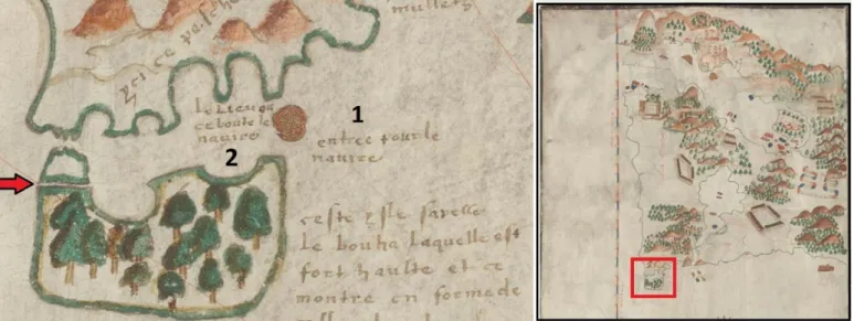
On this first phase of Portuguese settlement in the region, historical data demonstrate that the nearby sea Holocene sandy spit of “Massambaba” was still in progression. Some authors suppose that besides the Itajurú channel, there was another connection between the Araruama Lagoon and the ocean (Beranger, 1993), however, a description made in 1665, refers that only existed one channel (Vasconcellos, 1865). Nevertheless, it seems that the tombolo was still in formation. Indeed, in 1587, describing the Cabo Frio cape, Gabriel Soares de Souza said that in fact it was an island, since between it and the land, there was a deep channel that the vessels were able to cross (Souza,
113 1851). Historical cartography confirms that the current cape
was at that time an island. As it can be seen on a detail from a map dated by 1579 (Jaquez de Vau de Claye, Le vrai pourttraict de Genevre et du Cap de Frie, National Library of France), between the land and Cabo Frio island, it is represented a smaller island unconnected to land (Fig. 3).
Even if we thought that the representation of the channel could be the one that exists nowadays, called “Boqueirão”, the map shows this straight channel (represented by the red arrow; Fig. 3) and a larger one above. The author even describes where it is situated the entrance to the vessels, mentioned by Gabriel Soares de Souza, and where they could safely sail on that channel between land and the smaller island (see numbers 1 and 2; Fig. 3). However, despite being an island, it was common for locals to refer to “Cabo Frio” as a cape (HOA, cx. 16, doc. 1827, fl. 1). A map from the year of 1715 (Fig. 4), also represents the Cabo Frio island totally separated from the inland with a wide space for
navigation trough them (Anonymous, Côte du Brésil du Cap Frio à Lagoa dos Patos, National Library of France).
As latter descriptions made in 1729 confirm, the situation was still the same. The cape was an island, since it was at a distance of a half league from the land and surrounded by the sea (HOA, cx. 22, doc. 2432, fl. 12). In 1746, vessels could still navigate through that passage.
The distance between the island and the continent was enough to concerned the municipally entities that if some enemies occupied the island, the trade between Rio de Janeiro and the North of Brazil could be in jeopardize, because Portuguese trade ships could be captured (HOA, cx. 37, doc. 3843, fl. 1; cx. 39, doc. 4072, fl. 5). These historical data seem to demonstrate that although there were anthropogenic actions on the region, the tombolo that partially connects the island to the continent, was still on the process of formation.
Fig. 3. Representation of the Cabo Frio island in 1579 and the tombolo still in progression (Jaquez de Vau de Claye, Le vrai pourttraict
de Genevre et du Cap de Frie, National Library of France, URL: gallica.bnf.fr/ark:/12148/btv1b55002622c/f1.item. Access: 12/01/2018).
5.2. The increase of anthropogenic actions and its result on
Araruama Lagoonal system configuration
Although several areas were still untouched, this does not mean that anthropogenic actions were not already taking place. In fact, since the arrival of the Europeans to the region that several forms of land use was slowly changing the landscape. For instance, the exploitation of wood was intense, namely by the exploitation of “pau Brasil” (e. g. Araujo, 1820; Lamego, 1946; Drummond 1997).
Besides, along with the agricultural lands, exploited by the religious orders and by the Cabo Frio inhabitants, there were already established in the region, at least, three sugar cane mills at “Saquarema”, “Pitanga” and “Parati” (HOA, cx. 22, doc. 2432, fl. 19v.-20. National Archive Brazil - From
now on designated by “NAB” - Sesmarias, BI 15.1550, mf. AN 220-2005, fl. 2. Lamego, 1946). Several smaller ones, used to the distillation of sugar cane were established in “Saquarema” (NAB, Sesmarias, BI 15.1545, mf. AN 220-2005, fl. 2v.); and nearby Cabo Frio town (NAB, Sesmarias, BI 15.1521, mf. AN 220-2005, fl. 1. NAB, Sesmarias, BI 15.1546, mf. AN 220-2005, fl. 2. NAB, Sesmarias, BI 15.1520, mf. AN 220-2005, fl. 2).
Along with sugarcane, cassava was also farmed in Araruama. Some documents reveal the existence of a cassava flour mill nearby the beach, and also one nearby Araruama lagoon (NAB, Sesmarias, BI 15.1617, mf. AN 222-2005. NAB, Sesmarias, BI 15.1634, mf. AN 222-2005). Such devices needed large quantities of wood and deforested areas to the employment of the respective cultures.
114 Cabo Frio was also important to provide wood to the
sugar cane mills around Guanabara Bay (Rio de Janeiro), an area where it was already shortage (Moreira, 2017).
For these reasons, it seems that the areas around the lagoonal systems were already extensively exploited. The increase in deforestation and agricultural land use, certainly had contributed to the intensification of sediments supply to the nearby sea Holocene sandy spit and the formation of the internal spits of Araruama lagoonal system. Indeed, a first approach on the analysis of the “sesmarias”, reveal a high concentration of these type of contracts on the western part of Araruama Lagoonal system.
Here, if we take into account that each one of the established new contracts made confrontation with one or more lands that belonged to another tenant or religious orders, the occupation of land was intense. The most part of them were established particularly near the localities of Iguaba, Araruama and also on a part of Saquarema (Table 1). This seems to happen because the lands between Iguaba and
São Pedro da Aldeia, belonged to the Jesuits, and the Benedictines which possessed lands from Saquarema until “Ponta Negra” (HOA, cx. 84, doc. 19443, fl. 1-2).
After 1759, when Jesuits were expelled from Portugal and from its colonies, including Brazil and therefore Cabo Frio (e.g. Lamego, 1946), some parts of land in São Pedro da Aldeia started to be sell by indigenous people for agricultural purposes (NAB, Sesmarias, BI 15.1600, mf. AN 221-2005). Meanwhile, historical data from the last decade of the XVIII century, reveals the intensification of deforestation on the Jesuits possessions, such as São Pedro da Aldeia, due to the fires that were made to clean the land for agriculture, and also, due to the illegal wood trade (HOA, cx. 174, doc. 12851, fl. 2-3v. HOA, cx. 157, doc. 11858).
Actually, an historical memory about Cabo Frio written on the year of 1797, refers that only on the hinterland forests wood could be found, since nearby the coast these were already inexistent (Anonymous, 1883).
Fig. 4. Representation of the Cabo Frio island in 1715 (Anonymous, Côte du Brésil du Cap Frio à Lagoa dos Patos, National Library of
France, URL: gallica.bnf.fr/ark:/12148/btv1b53121783r/f1.item Access: 12/01/2018).
The rivers of this western area, used to inundate the land on raining season, such as for example, occurred every year with the Mataruna River (HOA, cx. 55, doc. 5456). As it was mentioned, more than 50 % of the fluvial drainage contribution to the lagoon, becomes from this river and the nearby River “Rio das Moças” (Kjerfve et al., 1996). For these reason, the principal input of fluvial fine organic sediments occurs in this area of the lagoon (Azevedo, 1984).
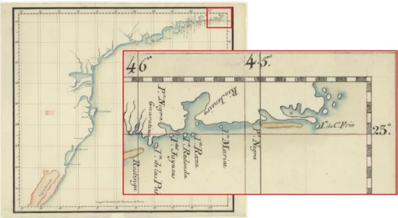
The scenario of deforestation and agricultural land use, occurred from the mid XVIII century forward, and those fluvial discharges, certainly increased the deposit of sediments on that part of the water body contributing to the formation of the internal spits. Indeed, a map from the year of 1792, copied from another one of 1785, displays the internal spits still on progression (Fig. 5).
115
Tab. 1. “Sesmarias” (contracts of land) around Araruama and Saquarema Lagoonal systems (1720-1822).
Date Location Source
1720, January, 15 Iguaba Grande NAB, Sesmarias, BI 15.1524, mf. AN 220-2005
1720, October, 22 Araruama NAB, Sesmarias, BI 15.1562, mf. AN 220-2005
1725, March, 20 Iguaba NAB, Sesmarias, BI 15.1524, mf. AN 220-2005
1725, October, 12 Saquarema NAB, Sesmarias, BI 15.1545, mf. AN 220-2005
1728, October, 1 Iguaba NAB, Sesmarias, BI 15.1524, mf. AN 220-2005
1730, April, 12 Iguaba Grande NAB, Sesmarias, BI 15.1496, mf. AN 169-2005
1731, February, 23 Tingui Saquarema NAB, Sesmarias, BI 15.1582, mf. AN 221-2005
1731, March, [12] Iguaba Mirim NAB, Sesmarias, BI 15.1558, mf. AN 220-2005
1747, September, 9 Iguaba NAB, Sesmarias, BI 15.1550, mf. AN 220-2005
1748, June, 26 Cabo Frio NAB, Sesmarias, BI 15.1581, mf. AN 221-2005
1749, August, 20 Engeitado NAB, Sesmarias, BI 15.1520, mf. AN 220-2005
1750, January, 21 Cabo Frio NAB, Sesmarias, BI 15.1521, mf. AN 220-2005
1750, August, 18 Saquarema NAB, Sesmarias, BI 15.1582, mf. AN 221-2005
1751, May, 24 Ponta das Bananeiras NAB, Sesmarias, BI 15.1624, mf. AN 222-2005
1751, December, 11 Iguaba Mirim NAB, Sesmarias, BI 15.1561, mf. AN 220-2005
1752 [?] Iguaba Mirim NAB, Sesmarias, BI 15.1531, mf. AN 220-2005
1752, November, 14 Cabo Frio NAB, Sesmarias, BI 15.1594, mf. AN 221-2005
1753, March, 14 Cabo Frio NAB, Sesmarias, BI 15.1546, mf. AN 220-2005
1753, March, 15 Araruama NAB, Sesmarias, BI 15.1617, mf. AN 222-2005
1753, April, 7 Iguaba Mirim NAB, Sesmarias, BI 15.1527, mf. AN 220-2005
1755, April, 6 Araruama NAB, Sesmarias, BI 15.1593, mf. AN 221-2005
1755, September, 9 Saquarema NAB, Sesmarias, BI 15.1602, mf. AN 221-2005
1756, January, 23 Araruama NAB, Sesmarias, BI 15.1590, mf. AN 221-2005
1756, March, 5 Araruama NAB, Sesmarias, BI 15.1608, mf. AN 221-2005
1756, November, 25 Araruama NAB, Sesmarias, BI 15.1634, mf. AN 222-2005
1758 [?] Iguaba NAB, Sesmarias, BI 15.1524, mf. AN 220-2005
1758, August, 22 Iguaba Mirim NAB, Sesmarias, BI 15.1604, mf. AN 221-2005
1759, May, 2 Iguaba Mirim NAB, Sesmarias, BI 15.1598, mf. AN 221-2005
1760, May, 19 Iguaba Mirim NAB, Sesmarias, BI 15.1623, mf. AN 222-2005
1761, March, 22 Saquarema NAB, Sesmarias, BI 15.1569, mf. AN 220-2005
1763, July, 22 Araruama NAB, Sesmarias, BI 15.1512, mf. AN 220-2005
1764, May, 14 Tingui River Saquarema HOA, cx. 71, doc. 6529
1767, July, 1 Araruama NAB, Sesmarias, BI 15.1507, mf. AN 169-2005
1767, Abril, 25 Iguaba Mirim NAB, Sesmarias, BI 15.1599, mf. AN 221-2005
1768, December, 18 Araruama NAB, Sesmarias, BI 15.1541, mf. AN 220-2005
1770, June, 10 Iguaba Mirim NAB, Sesmarias, BI 15.1528, mf. AN 220-2005
1770, October, 5 Mataruna /Araruama NAB, Sesmarias, BI 15.1559, mf. AN 220-2005
1771, August, 17 Araruama NAB, Sesmarias, BI 15.1556, mf. AN 220-2005
1772 [?] Ponta das Bananeiras NAB, Sesmarias, BI 15.1503, mf. AN 169-2005
1772, March, [?] Praia dos Anjos / Cabo Frio and
Araruama NAB, Sesmarias, BI 15.1614, mf. AN 222-2005
1772, March, 17 Araruama NAB, Sesmarias, BI 15.1516, mf. AN 220-2005
1772, March, 17 Sandy spit between the sea and
Sacoarema Lagoon NAB, Sesmarias, BI 15.1587, mf. AN 221-2005
1772, April, 4 Tamanduá / Araruama NAB, Sesmarias, BI 15.1515, mf. AN 220-2005
1772, April, 18 Paraty / Araruama NAB, Sesmarias, BI 15.1505, mf. AN 169-2005
1772, April, 18 Araruama NAB, Sesmarias, BI 15.1629, mf. AN 222-2005
1772, April, 23 Iguaba NAB, Sesmarias, BI 15.1605, mf. AN 221-2005
1772, April, 24 Araruama NAB, Sesmarias, BI 15.1511, mf. AN 220-2005
1773, May, 21 Araruama HOA, cx. 132, doc. 10513
116
Tab. 1. (cont.) “Sesmarias” (contracts of land) around Araruama and Saquarema Lagoonal systems (1720-1822).
Date Location Source
1776, September, 3 Saquarema (Ponta Negra) HOA, cx. 101, doc. 8628
1777, November, 9 Paraty / Araruama NAB, Sesmarias, BI 15.1551, mf. AN 220-2005
1782, [?], 15 Iguaba Grande NAB, Sesmarias, BI 15.1522, mf. AN 220-2005
1790, June, 10 Araruama NAB, Sesmarias, BI 15.1509, mf. AN 169-2005
1791, March, 30 Between Saquarema mountain
and Bacaxá HOA, cx. 142, doc. 11092
1792, November, 5 Campo de Alecrim / São Pedro
da Aldeia NAB, Sesmarias, BI 15.1600, mf. AN 221-2005
1796, December, 20 Boqueirão mountain
(Saquarema) HOA, cx. 167, doc. 12433
1806, September, 23 Saco da Aldeia / Saquarema NAB, Sesmarias, BI 15.1616, mf. AN 222-2005
1821, January, 8 Saquarema / Ponta Negra NAB, Sesmarias, BI 15.1548, mf. AN 220-2005
1821, January, 10 Cabo Frio NAB, Sesmarias, BI 15.1597, mf. AN 221-2005
1822, August, 22 São Pedro da Aldeia NAB, Sesmarias, BI 15.1594, mf. AN 221-2005
Fig. 5. Representation of Araruama lagoonal system in 1785 with the internal spits still in progression (Pedro Antonio
Cerviño, Carta plana de la costa del Brasil, que contiene desde las islas de Sta. Ana hasta la punta Joatinga, copiado de un original portugues impreso en el janeiro, en 1785, National Library of Brazil, Cart 512347, URL: http://objdigital.bn.br/acervo_digital/div_cartografia/cart512347/cart512347.jpg Access: 12/01/2018).
Some authors suggest a process of frequent oscillations in the mean relative level of the Araruama lagoon watershed, on a recent chronology of few centuries, with an induced and accelerate process of the Holoceno internal spits constitution (Alves, 2006). This data seems to corroborate that the anthropogenic actions described above, specially
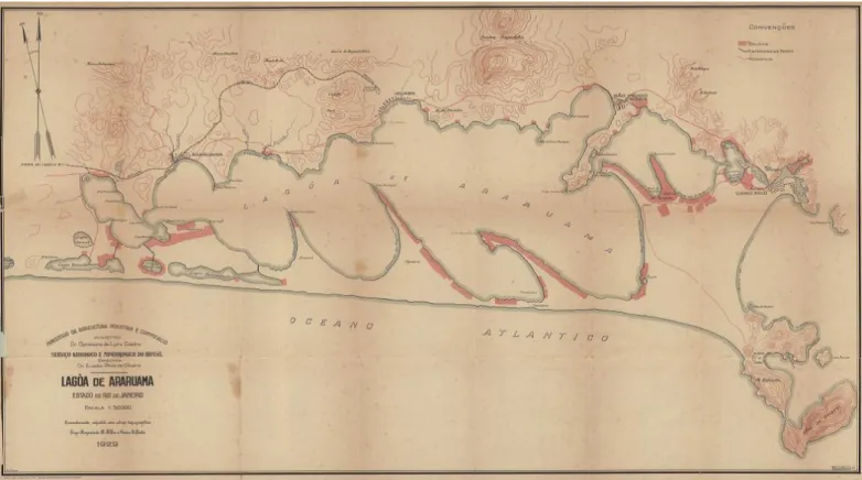
occurred on the western part of the lagoon, allied to a most significant fluvial drainage to the waterbody, had accelerate the process of the internal spits constitution. Effectively, the historical cartography represents an increase of these sandbars since in the begging of the XX century the internal spits were already pronounced (Fig. 6). However, in the last
117 half of the century, the spits are in an erosion process, what
it could mean a reduction of sediment supply to the lagoon and anthropic changes that had enhance this process, such as, the construction of salt pans (Alves, 2006). Indeed, the hypersaline characteristics of Araruama lagoon had contributed to salt exploitation along the history of human occupation, increased since the Portuguese colonization of the region and particularly after the XIX century (Lamego, 1946; Giffoni, 2000; Holzer, 2004; Pereira et al., 2016, 2017).
Benedictine lands around Saquarema lagoon were also occupied between the end of the XVIII and the first decades of XIX century, since some contracts reveal virgin lands that started to be cleansed to agricultural purposes and establishment of several types of plantations and sugar mill (HOA, cx. 101, doc. 8628. HOA, cx. 142, doc. 11092. NAB, Sesmarias, BI 15.1548, mf. AN 220-2005). Parts of the
Saquarema sandy spit also started to be occupied (NAB, Sesmarias, BI 15.1569, mf. AN 220-2005. NAB, Sesmarias, BI 15.1587, mf. AN 221-2005). The same happened on the Tinguí river margin, one of the principal fluvial courses that flows to this lagoon (HOA, cx. 71, doc. 6529).
As it happens on the fluvial courses of the western part of the Araruama region, in Saquarema lagoon, on raining season, the level of waters raised at a point that travelers couldn’t cross the rivers. The water that came from the mountains and flowed to the lagoon, used to inundate the village, forcing the inhabitants to open a channel and drain it to the ocean. When the sandy spit was closed and the lagoon had no connection with the ocean, and travelers reached the coast crossing the sandy spit, when opened, the crossing was done by boats (Anonymous, 1883).
Fig. 6.The Araruama lagoonal System in 1929, with a representation of the salt pans (Moraes Martins, Mario S. Pinto,
Raimundo R. Filho; Serviço Geológico e Mineralógico do Brasil, Lagoa de Araruama 1929, NAB, BR RJANRIO 04.0.MAP.195).
The level of sediment flowing into the lagoon was so intense that, although it was possible to enter vessels, in 1822 the channel was completely silted (Saint-Hilaire, 1941). According to Conder (1830, Vol. XXIX, p. 199), the Saquarema lagoon “(…) has a bottom of hard sand and is no more than three feet deep in most places. During the rainy season, it inundates the country, and opens for itself a rough, shallow channel to the sea. The river Tinguy, which runs into its most northern bay, is the principal one that flows into it”.
In 1845 the inhabitants of Saquarema needed to artificially open the channel (Saint-Adolphe, 1845, tome II), what seems to demonstrate that it was no longer possible the natural reestablishment between the lagoon and the sea. Indeed, between the XVII and XIX centuries a connection between the lagoon and the sea opened naturally. Afterward, only with the intervention of man, it was possible to re-establish such connection (Oliveira and Krau, 1955). The cartography represents a pronounced submerse sand bank
118 along the coast of Saquarema and Araruama lagoons, as it
can be seen on the maps of 1715 (Fig. 4) and also of 1792 (Fig. 5). This sediment seems to be a consequence of the intermittent discharges of the Saquarema lagoon.
In fact, some descriptions point out that when the lagoon was open, the water flowed into the sea, but the natural channel closed again in a short period of time (Saint-Hilaire, 1941; Saint-Adolphe, 1845, tome II). These seems to support that large quantities of sediments where discharged when the channel was open. Some studies argue that the sediments of Massambaba should be provided from the inner shelf and not for the littoral longshore transport (Muehe and Corrêa, 1989). One of the reasons pointed out is the impossibility of the river drainage due to the existence of sand spits (Muehe and Carvalho, 1993). However, historical data, as seen, shows that before total enclosure of Saquarema lagoon, relevant drainage of sediments to the ocean occurred at least until the XIX century. The sediments input to the shoreline result of a process that combines frontal accretion with longshore sediment transport (Muehe and Corrêa, 1989). In the littoral between Guanabara Bay (Rio de Janeiro) and Cabo Frio, the beach arches orientation is approximately E-W, a reflex of the bathymetric curves of the continental shelf, with direct influence on the incidence of ocean waves on the coast (Muehe and Carvalho, 1993).
Therefore, taking into account the historical data that describes the tombolo of Cabo Frio still in progression, it is possible to suggest that the anthropic actions that resulted in an increase of the sedimentary supply to the littoral which in addition to the natural processes contributed to the formation of the sandbank in the vicinity of the sea along the Holocene.
6. Conclusion
The formation of Araruama lagoonal system was greatly debated, however the anthropogenic actions that could have concurred to the formation of the Holocene sandy spit and the internal spits were not take into account. Those discussions started to contradict Alberto Ribeiro Lamego thesis about the formation of Massambaba sandy spit. This study concludes that, although such opinions, the longitudinal transport of large quantities of sediments through coastal drift currents, and the growth of internal spits parallel to the shoreline, were also possible, due to the increase of human activity on the areas around Araruama and Saquarema lagoonal systems. Trough historical sources, was showed that deforestation and agriculture land use, growth around those waterbodies, increasing the sediments deposit by fluvial discharges inside the lagoons. On the case of Araruama, such scenario contributed, at least, in part for the formation of the internal spits. In the case of Saquarema, contributed to the configuration of the Massambaba sandy
spit due to the longshore transport and the location of Cabo Frio island.
Acknowledgments
The first author would like to thank the FAPERJ research grant E-26/201.582/14.
Primary Sources
Historical Overseas Archive, Overseas council, Brazil, Rio de Janeiro, cx. 10, doc. 1046; cx. 13, doc. 1407; cx. 16, doc. 1827; cx. 18, doc. 38, doc. 2038; cx. 22, doc. 2432; cx. 37, doc. 3843; cx. 39, doc. 4072; cx. 50, doc. 4976; cx. 52, doc. 5241; cx. 55, doc. 5456; cx. 71, doc. 6529; cx. 84, doc. 19442, doc. 19443; cx. 101, doc. 8628; cx. 132, doc. 10513; cx. 142, doc. 11092; cx. 157, doc. 11858; cx. 167, doc. 12433; cx. 174, doc. 12851.
National Archive, Brazil, Rio de Janeiro, Sesmarias, BI 15.1496, mf. AN 169-2005; BI 15.1503, mf. AN 169-2005; BI 15.1505, mf. AN 169-2005; BI 15.1507, mf. AN 169-2005; BI 15.1509, mf. AN 169-2005; BI 15.1511, mf. AN 2005; BI 15.1512, mf. AN 220-2005; , BI 15.1515, mf. AN 220-220-2005; 15.1516, mf. AN 220-220-2005; BI 15.1517, mf. AN 220-2005; BI 15.1520, mf. AN 220-2005; BI 15.1521, mf. AN 220-2005; BI 15.1522, mf. AN 220-2005; BI 15.1524, mf. AN 220-2005; BI 15.1527, mf. AN 220-2005; BI 15.1528, mf. AN 220-2005; BI 15.1629, mf. AN 222-2005; BI 15.1531, mf. AN 220-2005; BI 15.1541, mf. AN 220-2005; BI 15.1545, mf. AN 220-2005; BI 15.1546, mf. AN 220-2005; BI 15.1548, mf. AN 220-2005; BI 15.1550, mf. AN 220-200; BI 15.1550, mf. AN 220-2005; BI 15.1551, mf. AN 220-2005; BI 15.1556, mf. AN 220-2005; BI 15.1558, mf. AN 220-2005; BI 15.1559, mf. AN 220-2005; BI 15.1561, mf. AN 220-2005; BI 15.1562, mf. AN 220-2005; BI 15.1569, mf. AN 220-2005; BI 15.1581, mf. AN 221-2005; BI 15.1582, mf. AN 221-2005; BI 15.1587, mf. AN 221-2005; BI 15.1590, mf. AN 221-2005; BI 15.1593, mf. AN 221-2005; BI 15.1594, mf. AN 221-2005; BI 15.1597, mf. AN 221-2005; BI 15.1598, mf. AN 221-2005; 15.1599, mf. AN 221-2005; BI 15.1600, mf. AN 221-2005; BI 15.1602, mf. AN 221-2005; BI 15.1604, mf. AN 221-2005; BI 15.1605, mf. AN 221-2005; BI 15.1608, mf. AN 221-2005; BI 15.1614, mf. AN 222-2005; BI 15.1616, mf. AN 222-2005; BI 15.1617, mf. AN 222-2005; BI 15.1623, mf. AN 222-2005; BI 15.1624, mf. AN 222-2005; BI 15.1634, mf. AN 222-2005.
Cartographic Sources
Anonymous, Côte du Brésil du Cap Frio à Lagoa dos Patos,
National Library of France, URL:
gallica.bnf.fr/ark:/12148/btv1b53121783r/f1.item Access:
12/01/2018
Jaquez de Vau de Claye, Le vrai pourttraict de Genevre et du Cap
de Frie, National Library of France, URL:
gallica.bnf.fr/ark:/12148/btv1b55002622c/f1.item Access:
12/01/2018
Moraes Martins, Mario S. Pinto, Raimundo R. Filho, Serviço Geológico e Mineralógico do Brasil, Lagoa de Araruama 1929, NAB, BR RJANRIO 04.0.MAP.19
Pedro Antonio Cerviño, Carta plana de la costa del Brasil, que contiene desde las islas de Sta. Ana hasta la punta Joatinga, copiado de un original portugues impreso en el janeiro, en 1785, National Library of Brazil, Cart 512347, URL:
119
http://objdigital.bn.br/acervo_digital/div_cartografia/cart51 2347/cart512347.jpg Access: 12/01/2018
References
Alves, A.R., 2006. Modelagem numérica aplicada ao estudo da origem e evolução morfológica dos esporões da lagoa de Araruama – RJ. Thesis (Programa de Pós-Graduação em Geologia e Geo-física marinha da Universidade Federal Fluminense, Brazil).
Anonymous, 1883. Memoria Historica da Cidade de Cabo Frio e de todo o seu Distrito Compreendido no termo de sua Jurisição anno de 1797. Revista Trimestral do Instituto Historico Geographico e Ethnographico do Brazil. Tomo XLVI, parte I, Rio de Janeiro, Typographia Universal de Laemmert e Cª, pp. 205-236.
Araujo, J. de S.A.P. de, 1820. Memorias Historicas do Rio de Janeiro e das Provincias Annexas À Jurisdicção do Vice-Rei do Estado do Brasil, Dedicadas a El-Rei Nosso Senhor D. João VI. Tomo I, Rio de Janeiro, Impressão Régia.
Azevedo, L.S.P., 1984. Considerações geoquimicas das lagunas do litoral leste do Estado do Rio de Janeiro. In: Lacerda, L. D., Araujo, D. S. D., Cerqueira, R., Turcq, B. (org.), Restingas: origem, estrutura, processos, Niterói, Ceuff, pp. 123-135. Barbiére, E.B., 1975. Ritmo climático e extração do sal em Cabo
Frio. Revista Brasileira de Geografia, vol. 37 (4), Rio de Janeiro, Instituto Brasileiro de Geografia e Estatística, pp. 23-109. Barbiére, E.B., 1985. Cabo Frio e Iguaba Grande, dois microclimas
distintos a um curto intervalo especial. In: Lacerda, L. D., Araujo, D. S. D., Cerqueira, R., Turcq, B. (org.), Restingas: origem, estrutura, processos, Niterói, ceuff, pp. 3-12.
Beranger, A.F., 1993. Dados Históricos de Cabo Frio. Cabo Frio: PROCAF – Companhia de desenvolvimento de Cabo Frio. Bidegain, P., 2005. Plano das Bacias Hidrográficas da Região dos
Lagos e do rio São João. Rio de Janeiro: Consórcio Intermunicipal para Gestão das Bacias Hidrográficas da Região dos Lagos, Rio São João e Zona Costeira. URL: http://www.inea.antigo.rj.gov.br/recursos/downloads/comit e_lagos_sao_joao_plano_bacia.pdf Access: 23/01/2018. Bidegain, P., Bizerril, C., 2002. Lagoa de Araruama - Perfil
Ambiental do Maior Ecossistema Lagunar Hipersalino do Mundo. Rio de Janeiro: Projeto Planágua Semads, URL: http://www.bibliotecaflorestal.ufv.br/handle/123456789/10 812 Acess: 23/01/2018.
Coe-Neto, R. 1984. Algumas considerações sobre a origem do sistema lagunar de Araruama. In: Lacerda, L. D., Araujo, D. S. D., Cerqueira, R, Turcq, B. (org.), Restingas: origem, estrutura, processos, Niterói, Ceuff, pp. 61-63.
Conder, J., 1830. The modern traveler. Description, Geographical, Historical, and topographical, various countries of the globe in thirty volumes. Vol. XXIX, London, James Duncan.
Dias, G.T.M., Kjerfve, B., 2009. Barrier and Beach Ridge Systems of the Rio de Janeiro Coast. In: Dillenburg, S. R., Hesp, P. A. (eds.) Geology and geomorphology of Holocene Coastal Barriers of Brazil. Lecture Notes in Earth Sciences, 107, Berlim, Springer-Verlag, pp. 225-252.
Drummond, J.A., 1997. Devastação e preservação ambiental: os parques nacionais do estado do Rio de Janeiro. Niterói, Editora da Universidade Federal Fluminense.
Fernandes, F. L. 2008. A Feitoria Portuguesa do Rio de Janeiro. História, 27 (1), pp. 155-194.
Giffoni, J.M., 2000. Sal: um outro tempero ao Império (1801-1850). Rio de Janeiro, Arquivo Público do Estado do Rio de Janeiro.
Holzer, W., 2014. O Sabor do Sal: Paisagens Vernaculares da
Araruama, Geograficidade, v. 4, URL:
http://www.uff.br/posarq/geograficidade/revista/index.php /geograficidade/issue/archive Acess 12/02/2018
Kjerfve, B., Schettini, C. A. F., Lessa, G., Ferreira, H. O. 1996. Hydrology and salt balance in a large hypersaline coastal lagoon: Lagoa de Araruama, Brazil. Estuarine, Coastal and Shelf Science, 42, 701-725. https://doi.org/10.1006/ ecss.1996.0045
Lamego, A. R. 1955. Ciclo Evolutivo da Lagunas Fluminenses. In: Anuário Geográfico do Estado do Rio de Janeiro. Rio de Janeiro, Serviço Gráfico do Instituto Brasileiro de Geografia e Estatística, pp. 2-45.
Lamego, A. R. 1946. O Homem e a Restinga. In: Sectores da Evolução Fluminense, Vol. II, Rio de Janeiro, IBGE.
Leal, A. 2012. Cabo Frio 1503. Rio de Janeiro, Batel.
Lamego, A. R. 1940. Restingas na Costa do Brasil. Boletim da Divisão de Geologia e Mineralogia (96), Rio de Janeiro, Departamento Nacional de Produção Mineral / Divisão de Geologia e Mineralogia.
Massa, H. 1980. Cabo Frio Histórico-Político. Cabo Frio, Prefeitura Municipal de Cabo Frio, Rio de Janeiro, Inelivro. McNeill, J. R. 2003. Observations on the Nature and Culture of
Environmental History. History and Theory, Theme Issue 42: Environment and History, No. 4, pp. 5-43.
Moreira, L.G.S., 2017. Cabo Frio e a montagem da primeira elite fluminense – séculos XVI e XVII. In: Ribeiro, F. M. F., Moreira, L.G.S. (org.), Cabo Frio 400 anos de História: 1615 – 2015, Cabo Frio / Rio de Janeiro, Instituto Brasileiro de Museus, pp. 25-47.
Muehe, D. 2006. Gênese da morfologia do fundo da lagoa de Araruama e cordões litorâneos associados. In: VI Simpósio Nacional de Geomorfologia / Regional Conference on Geomorphology, vol. II, Goiânia, União da Geomorgologia Brasileira, 2006.
Muehe, D., Carvalho, V. G. de. 1993. Geomortologia, cobertura sedimentar e transporte de sedimentos na plataforma continental interna entre a Ponta de Saquarema e o Cabo Frio (RJ). Boletim Instituto de Oceanografia, 41 (1/2), pp. 1-12. Muehe, D., Corrêa, C. H. T. 1989. Dinâmica de praia e transporte
de sedimentos na restinga de Maçambaba, RJ. Revista Brasileira de Geociências, 19 (3), pp. 387-392.
Myllyntaus, T., 2011. Preface: Methods in Environmental History. In: Myllyntaus, T. (ed.), Thinking trough the Environment. Green Approaches to Global History. Cambridge: White Horse Press, pp. 1-14.
Oliveira, L., Krau, L., 1955. Observações biogeográficas durante a abertura da Barra da Lagoa de Saquarema. Memórias do Instituto Osvaldo Cruz, 53, pp. 435-489.
Pádua, J.A., 2010. As bases teóricas da História Ambiental. Estudos Avançados, vol. 24, nº 68, pp. 81-101. URL:
http://www.revistas.usp.br/eav/issue/view/757 Access:
26/01/2018.
Pereira, O.N.A., Neffa, E.M.N.V. de, Bastos, M.R., Dias, J.A., 2017. A exploração de sal como motivo de antropização na laguna de Araruama: 1801-1900 (RJ, Brasil). In: Pereira, S.D.,
120
Rodrigues, M.A.C., Bergamaschi, S., Araújo-Junior, H. I., Cancela da Fonseca, L., Garcia, A. C., Roque, A. C. (org.), O Homem e o Litoral: transformações da paisagem ao longo do tempo/Tomo VI da Rede BrasPor, Rio de Janeiro, FAPERJ, pp. 312-331.
Pereira, O.N.A., Neffa, E.M.N.V. de, Bastos, M.R., Dias, J.A., Rodrigues, M.A.C. 2016. De Aveiro e Figueira da Foz (PT) para Arraial do Cabo (BR): influência de técnicas portuguesas na salicultura da laguna de Araruama, Rio de Janeiro, Brasil. In: Pereira, S. D., Rodrigues, M. A. C., Garcia, A.C., Cancela da Fonseca, L. (org.), Entre Rios e Mares: um Património de Ambientes, História e Saberes/Tomo V da Rede BrasPor, Rio de Janeiro, FAPERJ, pp. 47-61.
Saint-Adolphe, J.C.R.M. de, 1845. Diccionario Geographico, Historico e Descriptivo, do Imperio do Brasil. Tomo II, Paris, J. P.
Saint-Hilaire, A. de., 1941. Viagem pelo Distrito dos Diamantes e Litoral do Brasil com um Resumo Histórico das Revoluções do Brasil, da Chegada de D. João VI à América à Abdicação de
D. Pedro. Brasiliana, Biblioteca Pedagógica Brasileira, 5ª Série, Vol. 210, Rio de Janeiro, Companhia Editora Nacional. Souza, G.S., 1851. Tratado Descriptivo do Brazil em 1587. Rio de
Janeiro, Typographia Universal de Laemmert.
Turcq, B., Martim, L., Flexor, J. M., Suguio, K., Pierre, C., Tasayco-Ortega, L., 1999. Origin and evolution of the Quaternary coastal plain between Guaratiba and Cabo Frio, Rio de Janeiro state, Brazil. In: Knoppers, B., Bidone, E.D., Abrao, J.J. (eds.), Environmental Geochemistry of Coastal Lagoon Systems, Série Geoquímica Ambiental, vol. 6, Rio de Janeiro, Brazil, pp. 25-46.
Vasconcellos, P. S. de, 1865. Chronica da Companhia de Jesu do Estado do Brasil e do que obraram seus filhos nesta parte do Novo Mundo. Em que se trata da entrada da Companhia de Jesu nas partes do Brasil, dos fundamentos que nellas lançaram e continuaram seus religiosos, e algumas noticias antecedentes, curiosas e necessárias das cousas d’aquelle Estado. Vol. I, Lisboa, A. J. Fernandes Lopes.
Worster, D., 1991. Para fazer História Ambiental. Revista Estudos Históricos 4 (8), 198-215.