Enhancing Civil Engineering teaching through 3D Computer Aided
Design
To cite this article: J Gonçalves and B Santos 2019 IOP Conf. Ser.: Mater. Sci. Eng. 586 012045
Enhancing Civil Engineering teaching through 3D Computer
Aided Design
J Gonçalves1, B Santos2 1
University of Beira Interior, Calçada Fonte do Lameiro, 6200- 358, Covilhã,
Portugal(CITTA - Research Centre for Territory, Transports and Environment)
2
University of Beira Interior, Calçada Fonte do Lameiro, 6200-358, Covilhã, Portugal (CERIS-CESUR- Civil Engineering Research and Innovation for Sustainability) E-mail: [email protected]
Abstract. 3D interpretation of 2D drawing is not easy for most of the Civil Engineering
first-year students. Some do it naturally but most need to be trained to master this skill. In this paper, the implemented teaching methodologies aiming to facilitate the acquisition of three-dimensional project visualization skills are presented. These methodologies were developed during the last two years targeting first-year Civil Engineering students at the University of Beira Interior (Portugal). After a first contact with 2D project representation through manual drawing, students progressively elaborate computer-aided design (CAD) project starting with simple 2D drawings and culminating with a 3D project of a pre-existing building. Students are also motivated to improve their 3D graphic representation skills through a classroom contest where the winning project is printed in 3D. The training in 2D and 3D graphic representation is complemented during the second year with several in situ surveys and computer-aided drawing of topographic data. This approach proved to be very interesting for competence acquisition, qualifying students for a better 3D representation and interpretation. Students also found this methodology to be motivating.
1. Introduction
Science, technology, engineering and mathematics (STEM) are generally the least popular fields in most countries, with an average of only 24% of university graduates across OECD countries in 2016 [1]. Recent studies suggest that the number of STEM graduates at EU has remained generally stable in relation to the total number of university graduates, with a slight variation from 22.3% to 22.8% between 2006 and 2012 [2].
In this context, Shirazi A. and Behzadan A. [3] state that retaining and engaging students into the STEM fields is a major concern in the learning process. Outdated and poor teaching methods, disconnection between students and classroom technology, and lack of hands-on experiments are important reasons that keep some students away from pursuing STEM disciplines. Integrating technology into secondary and higher education, such as 3D design, can enhance student engagement and the quality of learning [4] [5] .
Portugal presents a particular situation, since Engineering is the most popular field among tertiary graduates, presenting 21% of graduates in 2016 for the field of study Engineering, Manufacturing and Construction, against a European average of 15% [6].
Over the last two decades there have been significant changes in Civil Engineering curricula in response to student, societal and industrial needs as well as professional bodies and government organisations. Some of the main factors contributing to this scenario are the easy access and the wide range of digital technology with application to project and engineering management (design and computational analysis). University curricula have responded to the growing professional appreciation of skills such as the domain of the available digital technologies and tools through a student-centred learning and teaching approach, grounded in critical thinking and problem-based learning.
According to Grand-Clement, S. [7] there is a need for digital skills to be better integrated in formal education and lifelong learning opportunities, in order to provide citizens with the tools they need to succeed in everyday life as well as in potential future careers.
Several authors and studies also refer this trend in education and in particular in the areas of Engineering, Manufacturing, Construction and Architecture [3] [8] [9] [10].
The fast development of science and technology, as well as economic and information globalization, had led to a recent education reform aiming to cultivate innovative engineers [11]. Knowledge is no longer the only measure of talent, students’ ability to master new knowledge and the capacity to innovate became equally important in the demanding labour market.
This paper intends to present the implemented teaching methodologies applied in the UBI Civil Engineering education aiming to facilitate the student’s acquisition of two and three-dimensional project visualization and interpretation skills using digital tools.
The paper is organized as follows: Section 2 presents a literature review of the drawing training methodologies applied in Civil Engineering education. Section 3 presents the teaching methodologies adopted in the last two academic years to motivate students in the Drawing and Topography subjects. Section 4 concludes the paper highlighting some reflections of the authors on the drawing training approaches implemented at the University of Beira Interior (UBI) and its importance in the Civil Engineering education.
2. Enhancing drawing training in Civil Engineering education
For an innovative Civil Engineering training it is important to have didactic materials to offer students recent and real problems with which they can interact, perform analyses and find solutions, promoting problem-based education (student-centred) and breaking the unilaterality of the knowledge transfer process.
Several Civil Engineering teaching research [9] [12] point-out the following difficulties in the learning process: great diversity and level of students preparation, lack of solid high school background knowledge, lack of experience in relating theoretical fundamentals to practical problems, lack of hardware and latest engineering software, lack of independent and critical thinking and lack of interest in active learning.
Among the strategies suggested to help teachers in promoting active learning are problem solving using computer-aided design. In that regard, project-based learning (PBL) has become a popular teaching method in engineering education as it provides students with opportunities to better understand the course material, gain more practical experience and learn how to apply theory to practice [5][13][14][15][16][17]. The literature indicates that PBL has several advantages over traditional methods namely as a didactic strategy: student engagement, critical thinking and team work, development of engineering identity, learning experience and theory-practice integration. Although this methodology is mainly applied to advanced year courses where students present a more mature level of knowledge, there is some evidence indicating that first-year engineering students also “generally enjoy the experience” and that PBL can also improve first-year student motivation and depth of learning [13].
Nevertheless, research [14] also suggests that a combination of traditional teaching methods with elements of PBL might be a good alternative as it allows different types of students to be satisfied: those who prefer projects and those who prefer traditional courses.
The use of digital technologies in PBL approaches help students arrive at their learning outcomes much faster. When carrying out a project, the use of graphic technologies and those relating to 3D modelling have a positive contribution towards improving the transmission of rigorous technical information and the understanding of spatial configurations. In this process scholars, rather than teaching how to use graphic technologies, use it to assist the students’ learning process.
According to Shirazi A. and Behzadan A. [3], most of the students consider themselves as visual learners, acquiring better engineering and scientific topics with 2D/3D visualization, complaining about the disconnection between how they perceive technology and how technology is in fact used in
the classroom. The new generation of students, which grew up in modern technology environment surrounded by computers, videogames and smart phones is eager to use digital technologies. Technology-based instruction along with conventional teaching methods enhance students learning and enable instructors to become more familiar with new technology-based educational innovations. Among the skills that Civil Engineering students must master project graphical representation is one of the basic. When representing any object, it can be drawn in a “flat” manner (drawing) or as a “solid” (3D model) [18]. Traditionally the results of civil engineering designs are several 2D drawings, which can be complemented by 3D models. 3D models allow untrained eyes to better understand how the project will look like when built. The 20 years of teaching experience of the authors have shown that 3D interpretation of 2D drawing is not easy for most of the Civil Engineering early years students. Some do it naturally but most need to be trained to master this skill.
According to Veide Z. and Strozheva V. [19] students’ spatial ability and visualization skills may be developed with help of different training tools and methodologies: graphic courses using traditional drafting methods (pencil and drawing board), 2D/3D CAD modelling, web-based graphics applications, augmented reality based application and sketch based modelling systems. However, Duarte J. [20] points out that hand drawing is still an essential skill in traditional design education and the basis for graphical representation teaching.
Regarding 3D printing, it can be seen as belonging to a set of emerging technologies with academic advantages as a didactic tool for the learning process in graphical representation. The use of this technology will undoubtedly change engineering curricula and how to educate future engineers. Ford S. and Minshall T. [21] mention a variety of benefits that have been identified arising from the incorporation of 3D printing technology into teaching: it can facilitate learning, develop skills, increase student engagement, inspire creativity and improve attitudes towards STEM subjects and careers, while increasing teachers’ interest and engagement. They also investigated the application of 3D printing in schools, universities, libraries and special education settings, and found six types of use: to teach students about 3D printing; to teach educators about 3D printing; as a support technology during teaching; to produce artefacts that aid learning; to create assistive technologies; to support outreach activities.
The disciplines of architecture and engineering were early adopters of rapid prototyping technologies to enhance teaching [5][21]. Rapid prototyping enables the production of physical models from digital ones and is used in the study of design and construction solutions. These studies can include 3D visualization of 2D designs or help to analyse more complex shapes [20].
3. Teaching experiences with 2D and 3D Computer Aided Drawing 3.1. Civil Engineering education at UBI
Currently, Portuguese Civil Engineering slowly begins to recover from the international crisis that led to an investment breakdown in construction, which led to a large decrease of local candidates for Civil Engineering courses offered by higher education institutions. To minimize this situation, in recent years UBI has invested in attracting international students, resulting in classrooms essentially composed of international students [22].
The integrated master’s degree in Civil Engineering is organized according to Bologna process and comprises a set of ten academic semesters along a five years’ graduation course, allowing the students to tailor their study plan on their own interests and to highlight the theoretical and practical aspects of distinct civil engineering domains. In this way, students can select one of two specialization areas (Geotechnical and Environment or Structures and Construction), have optional units available in the 1st semester of the fifth year and choose their dissertation topic in the last year [22].
The course units are grouped into 11 scientific areas: Drawing and Topography, Mathematics, Informatics, Chemistry, Mechanics and Structures, Construction, Physics, Geotechnics, Planning and Urbanism, Economics and Management, and Hydraulic and Environment [23].
The 3 course units of the scientific area Drawing and Topography, taught in the first two years of the study plan and in which computer-aided design tools are used to enhance the teaching-learning process, are presented below.
3.2. The role of 3D drawing in Civil Engineering training
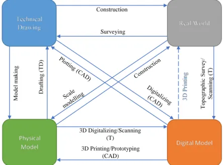
It is unquestionable the relevance of technical drawing in Civil Engineering. In general, civil engineers cannot afford to test real life projects due to costs and impacts in the surrounding environment and populations. Thus, drawings are essential to visually communicate the engineer’s idea to properly instruct on how to build or give a glance on how it will look. This means that not only the engineer but also the reader of the drawing must communicate with the same technical “language”. This language must be learned and trained to minimize communication problems and prevent construction mistakes. Figure 1 presents the existing relationships between real-world features and its depiction through 2D technical drawings, digital models (2D/3D) and 3D physical models, illustrating possible interconnections among these types of representation.
3D Printing/Prototyping (CAD) 3D Digitalizing/Scanning
(T) Surveying
TD – Technical Drawing; CAD – Computer Aided Design; T - Topography
Figure 1. Relations between real-world features and its possible representations: Technical drawing, Digital model and Physical model.
The real-world features have traditionally been depicted by drawing and scaled models. Civil Engineering has used them since mankind started to build. The rising of the digital era brought new ways to communicate ideas and the proliferation of low-cost 3D printing devices made modelling affordable to be used as a teaching tool. There are even examples of full scale 3D printing of small buildings [24][25].
In the Civil Engineering course at UBI, the Drawing and Topography scientific area comprise 3 course units that gradually train students in basic technical drawing skills. Table 1 presents how manual drafting, computer-aided design and cartography knowledge are introduced to students in the early course years.
Table 1. Drawing skills introduced in Drawing and Topography course units. Course Unit (Year/Semester) Manual drafting Computer Aided Design Cartography
Introduction to Civil Engineering and to Technical Drawing (1Y/1S)
Technical drawing standards, 2D plans, elevation, sections General concepts of CAD Map reading, contour lines and profiles properties Technical Drawing for Civil
Engineering (1Y/2S)
2D drafting, 3D project
Digital Terrain Model (DTM)
Topography (2Y/1S) Field sketches 2D drafting, terrain
model
Field surveys, data georeferencing, contour lines, 3D drawing
3.3. Technical Drawing - 2D drawing training
The Technical Drawing subject is taught in the first semester of the first-year course of Introduction to Civil Engineering and Technical Drawing. It is the students’ first contact with specific Civil Engineering courses and it is divided into two distinct subjects. In the first half of the semester, students are introduced to Civil Engineering history, to different types of civil engineering projects (Geotechnics, Structures, Hydraulics, Roads, Urban Planning, Construction and Environment) and perform analysis of case studies and real-life projects or construction system. In the second half, students are introduced to technical drawing basic standards, to projections, to cartography principles, orthographic projection of buildings and to civil engineering technical drawing. The students apply these knowledge with the accomplishment of an individual manual drafting work of an industrial pavilion. The lectures are organized in theoretical classes, with explanation of the program contents; and practical classes, where small practical exercises and guidance for the manual drafting of floor plans, elevations and sections of a given sketch are performed.
At the end of the semester, students must prove that they have acquired knowledge about basic civil engineering drawing skills to execute and read 2D civil engineering technical drawings. The evaluation of this knowledge includes written tests and 2 assignments: manual drawing of a terrain profile and orthographic projections of a building.
The subjects taught in the second half of the semester are essential and intend to be the grounding knowledge for students to understand and execute technical drawing in Civil Engineering domain. 3.4. Computer Aided Design - 2D and 3D drawing training
The Computer Aided Design is a subject taught in the second semester of the first-year course of Technical Drawing for Civil Engineering. It complements the introductory Technical Drawing subject of the first semester with more training in civil engineering specific design. The classes are organized in theoretical classes, with discussion of the program contents; and laboratorial classes, where students develop computer aided design projects.
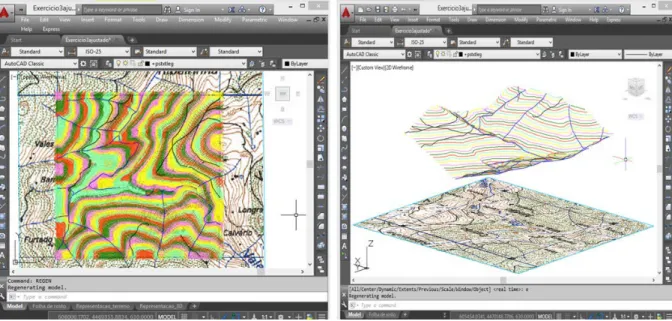
During the semester, students are introduced to 2D and 3D computer-aided design using AutoCAD® software from AutoDesk. Using knowledge acquired during the course, students learn how to transform coordinates form a map, how to digitally georeference a raster image (map) and how to create a DTM (Fig. 2). In the final assignment, which aims to integrate the knowledge acquired throughout the semester, students draw a digital 2D building project, elevations and sections from printed plans. The final part of the assignment consists in preparing a printable full 3D SOLID model of the project (Fig. 3 and 4).
Figure 2. Digital terrain model from a georeferenced raster image and its 3D view: example of student work.
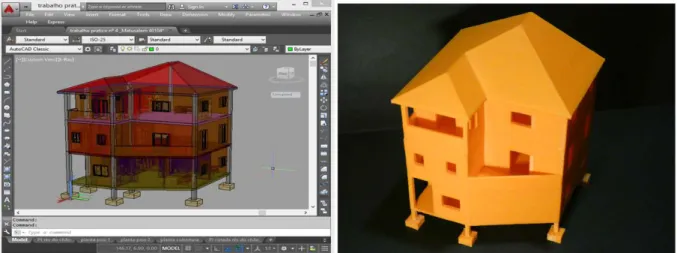
Figure 3. The 2016/2017 winning 3D model of a terraced house and its 3D printing.
The generic CAD process for 3D modelling is presented in Figure 5. Considering the acquired knowledge in manual technical drawing, students start the CAD design setting the drafting generic parameters such as layers, point type, object snapping, layouts, lettering style, line types or viewports. Due to the lack in computer-aided design background of most students, the first lessons focus on simple 2D drawings with the aim of familiarizing students with basic drawing and editing tools. The work then evolves to its 3D transformation were 3D operations are applied. After finishing the 3D design, students learn how to make the dimensioning and several ways to output the project.
At the end of the semester, students must prove that they have acquired knowledge about specific civil engineering technical drawings and skills to transform 2D technical drawings into solid 3D models. In 2016/2017 and 2017/2018, to enhance student motivation for the subject, a contest among students was proposed, awarding the best 3D project with its 3D printing (Fig. 3 and 4).
The 3D printing of the winning design was done through Fused Deposition Modelling (FDM) kit printers in laboratories at the university. This type of low-cost printers extrudes a narrow bead of hot plastic, which is selectively deposited where it fuses to the existing structure and hardens as it cools.
The 3D CAD model is transferred to the 3D printer as a standard data known as stereolithography language (STL), where the model is converted into layers that can be applied consecutively [24].
Figure 4. The 2017/2018 winning 3D model of a detached public building and its 3D printing.
Through these project-based learning methodologies students develop their 3D visualization skills, can better understand 2D interpretation mistakes and are motivated to pursue the Civil Engineering career. The evaluation of these knowledge includes written tests and the presentation of two 3D digital assignments (digital terrain model and orthographic projection of a building and its 3D project). 3.5. Topography
The Topography course is taught in the first semester of the second year and aims to introduce and develop aspects related to topography and its application to Civil Engineering. The classes are organized in theoretical lectures, with exposition of the program contents; theoretical-practical lectures, with small problems solving; and practical classes and tutorial orientations, with real practical problems solving through fieldwork and processing of collected data using computer programs.
Two-thirds of the practical and tutorials classes (20 contact hours) are dedicated to the acquisition of skills in the use of topographic instruments and a third (10 contact hours) in 2D/3D graphic representation. Students are encouraged to improve these skills with independent work using the resources available in the Drawing and Topography Laboratory.
At the end of the semester, students must have acquired enough knowledge to master topographic instruments (Digital Level and Total Station), calculations, fieldwork and digital 2D and 3D data representation. The evaluation of this knowledge includes a written test and 5 to 7 field assignments. A representation component using digital tools, where the technical drawing knowledge acquired in the first year is applied, is contemplated in the following 4 assignments:
- Digital level survey (expedite topographic survey and digital 2D representation).
- Total Station survey (rigorous topographic survey and digital 2D representation) (Fig.5).
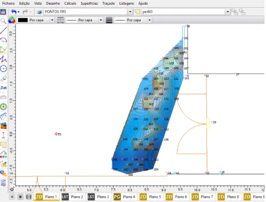
- Precision altimeter survey using digital level and total station (constructions observation and digital 2D and 3D representation – creation of triangulated irregular network, contour lines and DTM) (Fig. 6).
- Connection of local survey to a cadastral survey network using Global Navigation Satellite System (GNSS).
Figure 6. Rigorous topographic survey 2D representation in Cartomap®: example of student work.
The computer program used in the teaching-learning process for the fieldworks data representation, survey calculations, 2D/3D CAD design, terrain modelling, survey reports (stations, points and codes) and outputs creation is Cartomap®.
Figure 7. Precision altimetry survey representation in Cartomap®: example of student work - altimetry study of a slab deformation.
During the practical classes, students learn how to use the program in the context of topography works, but at the same time apply the technical drawing knowledge acquired in the courses of “Introduction to Civil Engineering and Technical Drawing” and “Technical Drawing for Civil Engineering”, improving their learning curve in digital representation and interpretation. These skills are extremely valuable for civil engineers, especially in today’s working world, since most jobs involve technical drawing representation and/or interpretation.
4. Final remarks
When representing any object, it can be drawn in a “flat” manner (drawing) or as a “solid” (3D model). Traditionally the results of civil engineering design are several 2D drawings representing 3D models. These drawings are essential to visually communicate the engineer’s idea to properly instruct on how to build or give a glance on how it will look. Teaching experience has shown that 3D interpretation of 2D drawing is not easy for most early year Civil Engineering students.
Among the strategies suggested in the literature to help teachers promoting active learning, project-based learning using computer-aided design combined with traditional teaching methods proved to be a good approach in Drawing and Topography subjects. This combination allows different types of students to be satisfied, those who prefer projects and those who prefer traditional courses.
In Portugal, teaching of technical drawing with 3D project is only available in 43% of Civil Engineering courses and 85% teach technical drawing and CAD.
A gradual students’ training in basic technical drawing skills has been accomplished at UBI Civil Engineering education through 3 units taught in early course years. Manual drafting, computer-aided design and cartography concepts are introduced through project-based learning approach. Students are also motivated to improve their 3D graphic representation skills through a classroom contest where the winning project is printed in 3D.
Considering the students’ multicultural background and lack of previous knowledge in drawing and 3D modelling, the contest proved to be a motivational approach in the learning process. Students have shown improvements in the skill-building process and inquires show that although most had
previously basic digital skills, the majority considered that 3D projects raised significantly their motivation and more than half considered the contest challenging. Inquiries also revealed that students need more time to develop drawing and 3D project skills.
Considering these outcomes, rearrangements have been suggested to incorporate a whole semester of technical drawing in the master’s curriculum, allowing deeper introduction to 2D digital drafting. This rearrangement would allow a full second semester dedicated to 3D projects.
5. References
[1] OECD. Education at a Glance 2018: OECD Indicators. Paris: OECD; 2018. doi:10.1787/eag-2018-en.
[2] STEM Alliance. Table of of contents. STEM Educ Factsheet 2016.
http://www.stemalliance.eu/publications (accessed January 28, 2019)
[3] Shirazi A, Behzadan A 2015 Content delivery using augmented reality to enhance students’ performance in a building design and assembly project. Adv Eng Educ 2015;Wnter
[4] UK Department of Education 2013 3D printers in schools: uses in the curriculum
[5] Rúa E, Jimenez F, Gutierrez G, Villamizar N. 3D Printing as a Didactic Tool for Teaching some Engineering and Design Concepts. Rev Ing 2018;23:70–83. doi:10.14483/23448393.12248. [6] Eurostat Database n.d. https://ec.europa.eu/eurostat/data/database (accessed December 20,
2018).
[7] Grand-Clement S, Devaux A, Belanger J, Manville C. 2017 Digital Learning: Education and skills in the digital age, doi:10.7249/CF369
[8] Newson T, Delatte N 2011 Case Methods in Civil Engineering Teaching. Can J Civ Eng 2011;38:1016–30, doi:10.1139/l11-023
[9] Shaaban K 2013 Practical teaching and its importance in teaching civil engineering. QScience Proc 2013, Glob Innov Conf 2013 2013:4–7, doi:10.5339/qproc.2013.gic.4
[10] Kara L. 2015 A Critical Look at the Digital Technologies in Architectural Education: When, where, and how? Procedia - Soc Behav Sci, 176:526–30, doi:10.1016/j.sbspro.2015.01.506 [11] Sun S, Su Z, Cui S 2017 Study on the continuing education innovative talents training mode of
civil engineering major. IOP Conf Ser Earth Environ Sci;100. doi:10.1088/1755-1315
[12] Oliveira P, Oliveira C 2014 Integrator element as a promoter of active learning in engineering teaching. Eur J Eng Educ; 39:201–11. doi:10.1080/03043797.2013.854318
[13] Marshall J, Bhasin A, Boyles S, David B, James R, Patrick A 2018 A Project-Based Cornerstone Course in Civil Engineering : Student Perceptions and Identity Development University of Texas at Austin. Adv Eng Educ 2018:1–25
[14] Gratchev I, Jeng D 2018 Introducing a project-based assignment in a traditionally taught engineering course. Eur J Eng Educ 2018; 43:788–99. doi:10.1080/03043797.2018.1441264. [15] Barrows H 1986 A taxonomy of problem-based learning methods. Med Educ; 20:481–6.
doi:10.1111/j.1365-2923.1986.tb01386.x
[16] Kapranos P 2013 Teaching and Learning in Engineering Education – Are We Moving with the Times? Procedia - Soc Behav Sci; 102:3–10. doi:10.1016/j.sbspro.2013.10.707
[17] Googdhew P. 2012 Teaching Engineering: Can we do it better? In: Kapranos, P. Brabazon D, editor. Proc. 4th Int. Symp. Eng. Educ., p. 1–7
[18] Sampaio A, Henriques P, Cruz C 2009 Interactive models used in Civil Engineering education based on Virtual Reality technology. Proc - 2009 2nd Conf Hum Syst Interact HSI ’09:170–6. doi:10.1109/HSI.2009.5090974
[19] Veide Z, Strozheva V 2015 The Visualizations Methods of Geometrical Forms in teaching of Civil Engineering Students. Proc. 10th Int. Sci. Pract. Conf., vol. 2, Rezekne, Latvia: Rezekne Higher Education Intitution, p. 312–6
[20] Duarte J 2007 Inserting new technologies in undergraduate architectural curricula: a case study. 25th ECAADe 2007:423–30
[21] Ford S, Minshall T 2019 Where and how 3D printing is used in teaching and education. Addit Manuf; 25:131–50. doi:10.1016/j.addma.2018.10.028.
[22] Santos B, Virtudes A, Gonçalves J, Amin S 2018 Multicultural Education in Civil Engineering: Planning and Transportation Approach. EDULEARN18 Conf., Palma de Mallorca, Spain: IATED 2018, p. 4991–5000.
[23] University of Beira Interior. Civil Engineering. Integr Master Degree Civ Eng n.d. http://www.ubi.pt/en/course/9 (accessed January 25, 2019).
[24] Yossef M, Chen A 2015 Applicability and Limitations of 3D Printing for Civil Structures. Conf Auton Robot Constr Infrastruct 2015:1–25.
[25] Sakin M, Kiroglu Y2017 3D Printing of Buildings: Construction of the Sustainable Houses of the Future by BIM. Energy Procedia 2017;134:702–11. doi:10.1016/j.egypro.2017.09.562
Acknowledgments
The authors acknowledge University of Beira Interior, CITTA - Research Centre for Territory, Transports and Environment (Multi/04427) and CERIS-CESUR- Civil Engineering Research and Innovation for Sustainability (ECI/04625) for supporting the performed study.
The authors also thank to Eng. Pedro Alves (MINILAB 3D) and Prof. Pedro Gabriel de Almeida (UBI) for the 3D printing of the 2016/2017 and 2017/2018 winning students’ final projects.