fore, it is necessary to reinforce the importance of establishing geoconservation strategies in the state of São Paulo (Garcia et al., 2018).
According to Brilha (2005), the human threats to geodiversity are mainly due to the ignorance of the general public, in relation to its importance, because in general, people tend to value and con-serve only what they know. Thus, educational activities play a fundamental role in the mental construction of geoconservation in people, mainly among those of school age. The development of educational activities in geosites with high poten-tial educational use allows students to have direct contact with geological aspects, helping to grow an interest in the region’s natural heritage (Oliveira, 2014).
From 2012 to 2015, the inventory of geological heritage of São Paulo state has been carried out, aiming to identify, select and evaluate geological heritage with national or state scientific relevance
Terræ
Didatica
Introduction
The inventory of geoheritage is the first step for any geoconservation strategy, and consists of a systematic approach to geologically relevant occur-rences in a certain area (Brilha, 2005).
The state of São Paulo has a territorial area of approximately 248 thousand km² (Brazilian Insti-tute of Geography and Statistics [IBGE], 2016), which has been the focus of several types of geo-logical investigations during the last 70 years. These investigations include activities such as description and collection of samples from geological outcrops for studies in mineralogy, petrology, geochemistry, geochronology and structural geology, and were essential to understand the geological history of the region. Due to intense weathering and urban-isation, many of these sites are at risk, in relation to their integrity, which makes scientific use com-plicated and sometimes until impossible. There-ARTIGO
Abstract: The inventory of the geological heritage of the state of São Paulo, Brazil, was carried out from 2012 to 2015 and resulted in the selection of 142 geosites in 11 geological frameworks representative of its geological history. Among the frameworks is the “Geomorphological units and landforms”, which includes fourteen geosites representative of the main geomorphological features in the area. Since these kinds of geosites are very suitable to interpretative and educational purposes, in this work we present both qualitative and quantitative assessments of the potential educational use of the geosites present in this geological framework. The assessment was carried out using the GEOSSIT platform, which was developed by the Geological Survey of Brazil (CPRM). The outcomes of the quantitative assessment made it possible to rank the geosites according to their importance. The geosites Jaraguá Peak and Itapeva Peak achieved the highest rankings, a result that reinforces their current use for tourist activities; on the other hand, the geosites Jureia Massif and Diabo Hill were the lowest ranked. The data obtained in this study suggest the need to establish educational measures that may increase activities of valorisation, dissemination and conservation of these geo-sites, and that take into account the geodiversity elements. In order to implement such measures, some support from public and private agencies is fundamental. In general, geosites present excellent conditions for the dissemination of geoscientific knowledge, making a key to the construction of a geoconservation conscience by the general public.
Manuscript:
Received: Quadrennial Conference of the In-ternational Geoscience Education Organization Accepted: 31/01/2019
Citation: Higa, K. K., Mucivuna, V. C., & Garcia,
M. da G. M. 2019. Potential educational use of geomorphological units and landforms: an approach from the inventory of the geological heritage of the State of São Paulo, Brazil. Terræ
Didatica, 15, 1-7, e19016. doi: 10.20396/
td.v15i0.8654665.
Keywords: Brazil, geoconservation strategies,
geodiversity, geoheritage, geosite, quantitative assessment.
Thematic line: Geoconservation, Geotourism
and Geoheritage.
Potential educational use of geomorphological units
and landforms: an approach from the inventory of the
geological heritage of the State of São Paulo, Brazil
Karina K. Higa, Vanessa C. MuCiVuna, Mariada glória M. garCia
Centrefor researCh supporton GeoloGiCal heritaGeand Geotourism (Geohereditas), instituteof GeosCienCes, universityof são paulo.
ruado laGo, 562, Cidade universitária, 05508-080, são paulo, sp, Brazil.
e-mails: [email protected], [email protected], [email protected]
Geological and Geomorphological
Characterisation
The general geological setting of the state of São Paulo is composed of two quite distinct domains: i) about 30% of the state area corresponds to Pre-cambrian rocks of the crystalline basement; ii) approximately 70% of the area is represented by sedimentary deposits (Garcia et al., 2018).
According to the Geomorphological Map by Ross and Moroz (1997), the study area can be subdivided into macro compartments (Morpho-structures) that are supported by large geological structures; and smaller compartments (Morpho-sculptures), which are influenced by exogenous processes of landforms sculpture (Garcia et al., 2018).
Three morphostructural units were defined in the state of São Paulo: i) Atlantic Orogenic Belt, for which five major tectonic domains are described: Joinvile Massif, Apiaí Fold Belt, São Roque Fold Belt, Guaxupé Massif and Uruaçu Fold Belt (Carneiro & Ponçano, 1981); ii) Paraná and (Garcia et al., 2018). The method applied in the
inventory was based on the model proposed by the European Association for the Conservation of Geological Heritage (ProGEO). As a result, 142 geosites representative of 11 geological frame-works that represent the geological history of the state were selected: Precambrian Terranes, Shear Zones, Granitic Rocks, Precambrian Metallic Min-eralisations, Paraná Basin, Mesozoic Magmatism, Bauru Basin, Continental Rift of Southeastern Brazil, Continental and Coastal Neogenic and Quaternary Evolution, Geomorphological Units and Landforms, and Caves and Karst Systems. For each framework, every selected geosite was char-acterised and quantified according to its scientific value and vulnerability.
Due to high educational potential, the fourteen geosites that compose the geological framework “Geomorphological units and landforms” were quantitatively assessed regarding their potential educational use (Figure 1). Based on the results, it was possible to evaluate their use for educational purposes.
Figure 1. Location map of the geosites of the geological framework “Geomorphological units and landforms” from the in-ventory of the geological heritage of the state of São Paulo: 1 Diabo Hill. 2 Marília Plateaus. 3 Structural Scarpment. 4 Pardinho Basaltic Cuestas. 5 Araçoiaba da Serra Dome. 6 Japi Mountains. 7 Voturuna Hill. 8 Jaraguá Peak. 9 Colônia Crater. 10 Jureia Massif. 11 Baú Stone. 12 Itapeva Peak. 13 Corcovado Peak. 14 Meteorite Impact Structure of Ubatuba
Bauru basins, with sediments from the Devonian/ Silurian to the Jurassic. After the Upper Jurassic, new tectonic processes occurred in both basins, originating new sedimentary sequences and basal-tic rocks, which complete the package that makes up the platform cover; iii) Cenozoic sedimentary basins (São Paulo, Taubaté and Coastal) developed in restricted areas of the Atlantic Shield.
Geosites with geomorphological interest
from the inventory
The inventory of geological heritage of state of São Paulo was carried out taking into account the scientific values of the geosites, and was devel-oped by the geoscientific community. Among the 11 frameworks, the “Geomorphological units and landforms” stands out because of the high poten-tial for educational use and because it presents excellent sites that can be used for interpretation activities.
The geosites of this framework exhibit geo-morphological interest. Panizza (2001) and Rey-nard (2004) conceptualize the geosites with geo-morphological interest as geogeo-morphological sites or geomorphosites, due to their specific character-istics. According to these authors, a geomorphosite is defined as a part of the Earth surface of impor-tance for the knowledge of the Earth, climate and life history. For Panizza (2001) a geomorphosite is a landform to which a value can be attributed. Just as geosites, the main value of a geomorphosite should be scientific, but it can have additional values such as aesthetic, cultural, ecological and economic (Reynard, 2005). These sites exhibit unique aspects regarding their geomorphology, and should be subjected to geoconservation strategies according to their natural importance (Reynard et al., 2009).
Table 1 summarises the main aspects of the 14 geosites included in the framework “Geomor-phological units and landforms”, and Fig. 1 shows their location.
Due to the large dimensions, according to their typology all the geosites in this geological frame-work have been classified as areas (Fuertes-Guti-érrez & Fernández-Martínez, 2010). This brings their relevance to be related not only to repre-sentativeness in terms of landforms, but also to specific geological units that control the relief. In the opinion of these authors, the area typology is represented by large-sized sites, involving only one type of interest.
Table 1. Brief description of the geosites
Geosite Municipality Description
Structural
Scarpment Itararé
A relief paleolandform originated thousands of
years ago
Jureia Massif Iguape
A granitic/gneiss relief in the middle of the coastal plain that can represent an ancient island that was
incorpo-rated to the continent by marine depositional processes Araçoiaba da Serra Dome Iperó, Capela do Alto and Araçoiaba da Serra
A hill form with a height of around 930 meters, that stands out in the middle of the low
relief
Jaraguá Peak São Paulo block with low erosive A quartzite structural ratio
Voturuna
Hill Araçariguma
Rock formation repre-sentative of the Atlantic Orogenic Belt
Morpho-structure Japi
Mountains Jundiaí
An important site for geomorphological stud-ies, representative of quartzite formation Pardinho Basaltic Cuestas Pardinho Site representative of the transition between the morphology of the peripheral depression and the western plateau
of São Paulo Baú Stone São Bento do Sapucaí
Site representative of the tectonic processes that gave rise to the Continental Rift of Southeastern Brazil Colônia
Crater São Paulo Unique impact crater Corcovado
Peak Ubatuba
Landform associated with the Serra do Mar
uplift and coastline evolution Itapeva Peak Campos do Jordão and Pindamo-nhangaba
Viewpoint with a view of Paraíba do Sul River Valley, situated at the
Continental Rift of Southeastern Brazil Marília Plateaus Marilia Landform made up of rocks of continental depositional environ-ments Meteorite Impact Structure of Ubatuba Ubatuba Possible Pleistocene crater, which shows the record of the entire Quaternary sedimentary
column of this region
Diabo Hill SampaioTeodoro
The greatest exposure of the inselbergs formed
by silicified sandstones from dune deposits of the ancient Caiuá
the sum of all criteria with their respective weights, with a final value between 0 and 400.
Quantitative assessment results
The quantification results of the potential educational use of the 14 geosites the geological framework “Geomorphological Units and Land-forms” are presented in Table 2.
Based on these results, the geosites were ranked according to their potential educational use, with indications of the sites that should be prioritised in future geoconservation measures.
In relation to the global value, all the geo-sites scored higher than 50%, with values varying between 51.25% and 81.25%. The sites with the highest scores are Itapeva Peak and Jaraguá Peak (81.25%), while the geosites Jureia Massif (53.75%) and Diabo Hill (51.25%) had the lowest scores.
Discussion
In order to understand the main factors that led to the discrepancies in relation to the PEU scores, the geosites of the highest (Itapeva Peak and Jaraguá Peak) and lowest (Jureia Massif and Diabo Hill) classifications will be discussed.
Most of these sites may be also used as view-points and some of them constitute, indeed, tra-ditional touristic observatories, such as Jaraguá Peak, Corcovado Peak, Itapeva Peak, Baú Stone, and Diabo Hill. In these cases, the geosites may be used both as geosite and also as viewpoints to geo-morphological landscape (Reynard, 2005, 2009).
In relation to potential uses, both areas and viewpoins exhibit easy or good sites for geoscien-tific popularisation.
Quantitative assessment of potential
educational use
Based on the inventory data, the next step involves the quantification of the geological heri-tage. The quantitative evaluation of geosites con-sists in assigning values for each criterion according to their relevance. The quantitative assessment of geosites becomes important due to the impossi-bility of applying conservation measures to all the elements of geodiversity. Moreover, the inclusion in a database where it is possible to verify which geosites have the greatest relevance makes possible the establishment of priorities in policies of valori-sation, divulgation and monitoring (Brilha, 2005).
Methods
All 14 geosites were assessed in relation to their potential educational use (PEU).
The quantification of PEU was made using the GEOSSIT platform (Rocha et al., 2016), developed by the Geological Survey of Brazil (CPRM), which aims to systematise inventories, and conduct both qualitative and quantitative assessments of geosites and geodiversity sites of the Brazilian geological heritage. The platform was initially structured on the basis of Brilha (2005) and Garcia-Cortés & Carcavilla Urquí (2009) methods. Recently, it was adjusted, and currently adopts the methods and concepts described in Brilha (2016), adapted to the Brazilian reality.
For PEU assessment, the platform uses the following criteria and weights (in percent): vul-nerability (10), accessibility (10), use limitations (5), safety (10), logistics (5), density of population (5), association with other values (5), scenery (5), uniqueness (5), observation conditions (10), didac-tic potential (20), and geological diversity (10). Each criterion can have a value between 0 and 4 points. The final value of each geosite is obtained based on
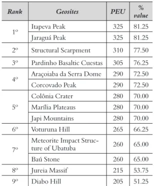
Table 2. Quantitative assessment of the potential educa-tional use (PEU) with respective ranking of the geosites from the geological framework “Geomorphological units and landforms”
Rank Geosites PEU value%
1º Itapeva Peak 325 81.25 Jaraguá Peak 325 81.25 2º Structural Scarpment 310 77.50 3º Pardinho Basaltic Cuestas 305 76.25 4º Araçoiaba da Serra Dome 290 72.50 Corcovado Peak 290 72.50 5º Colônia Crater 280 70.00 Marília Plateaus 280 70.00 Japi Mountains 280 70.00 6º Voturuna Hill 265 66.25 7º
Meteorite Impact
Struc-ture of Ubatuba 260 65.00 Baú Stone 260 65.00 8º Jureia Massif 215 53.75 9º Diabo Hill 205 51.25
First positions - Itapeva Peak and Jaraguá Peak
The high PEU values are justified by the char-acteristics of the geosites and surroundings that enable and facilitate their use by students. Accessi-bility, safety and infrastructure of the sites also con-tributed to the highest PEU score. Moreover, both geosites are located less than 100 m from a paved road, with vehicle parking available, with no restric-tions on use by students and tourists, with security infrastructure and rescue services at most 25 km away, and also close to restaurants and accommo-dations for large groups. Scenery, uniqueness and association with other values make these geosites even more interesting to students, increasing the value of the PEU. Itapeva Peak (Figure 2) and the Jaraguá Peak (Figure 3) are places frequently used in tourist campaigns, possess unique and rare aspects, have ecological and cultural values, and occur less than 10 km from the geosites. All these factors contributed to the high priority of both geosites.
Although both geosites have the same PEU score, some differences are pointed out: i) obser-vation conditions: in Itapeva Peak obserobser-vations are good, whereas in Jaraguá Peak there are obstacles that make observation difficult; ii) didactic poten-tial: in Itapeva Peak there are geological elements that can be taught to elementary students, whereas in Jaraguá Peak only for secondary students. In other words, Jaraguá Peak is more suitable for high educational levels than Itapeva Peak.
Both geosites work as viewpoints. According to Rodrigues (2013), geomorphological viewpoints are privileged sites for raising public awareness due to their aesthetic value, good visibility, magnitude and combination with other heritage sites. These geosites are already used for tourist activities and for landscape contemplation. For this reason, their promotion and valorisation should be more effec-tive, aiming at dissemination and interpretation of geodiversity aspects.
Jaraguá Peak is already used for educational activities by several elementary and secondary schools. Moreover, this geosite already has an envi-ronmental education program conducted by the Environmental Education Center of Jaraguá State Park (NEAPEJ). The NEAPEJ has environmental monitors who receive student groups for activi-ties focused on environmental education (Wick & Silva, 2013). However, these education actions do not focus on geodiversity elements, so comple-mentary courses on geodiversity could be given to environmental monitors (Garcia et al., 2016) in order to add abiotic elements to the environmental education activities already conducted.
Although Itapeva Peak also has high educational potential, currently there is no educational activity in progress.
Due to the high education potential, it would be important for scientific dissemination actions to be implemented. The characteristics of the geosites allow the installation of interpretative panels, which could contribute to the dissemination and inter-pretation of geodiversity for self-guided visitors or for visitors with guided interpretation (Rodrigues, 2013). Other interpretation aids such as leaflets, geotourist guidebooks and mobile applications are excellent means to promote the geosites for edu-cational and tourist uses (Migón & Pijet-Migón, 2017), but they are usually expensive.
Last positions - Jureia Massif and Diabo Hill
The geosites Jureia Massif (Figure 4) and Diabo Hill (Figure 5) had the lowest classifications among the studied sites. Although they have low vulnera-bility in relation to anthropic activity, have several elements of geodiversity, and are close to many ecological and cultural sites, the low rankings are justified due to poor accessibility, limitations on use, lack of security, restaurants and lodging for large groups are more than 50 km away, obstacles Figure 2. View of the Itapeva Peak, in Pindamonhangaba / SP Figure 3. View of Jaraguá Peak, in São Paulo / SP
Final remarks
The geological framework “Geomorphological units and landforms” of the inventory of the state of São Paulo comprises 14 geosites with values of potential educational use varying from 51.25% to 81.25%. The variation shows the importance of establishing a quantification method to rank geo-sites in order of importance, helping to prioritise them in future management plans.
It should be noted that the main differences between the highest and lowest PEU values are related to characteristics that can be modified, such as accessibility, limitations on use, safety and obsta-cles to observation, making it possible to increase these values, if required measures were taken.
This study showed that geosites Jaraguá Peak and Itapeva Peak are the most suitable for dissem-ination of geoscientific knowledge, because they achieved the greatest scores for potential educa-tional use, are already used for tourist activities, and are used as viewpoints, which contribute to their attractiveness to the general public. Interpretation facilities such as interpretative panels, leaflets, guides and mobile applications would make geo-sites more interesting in relation to interpretations activities. However, it would be necessary to find proper funding to pay these facilities, either from public or private agencies.
Finally, all the geosites of the geological frame-work “Geomorphological units and landforms” show potential to be utilized in interpretation and education. However, besides quantitative assess, it is necessary to evaluate qualitatively each geosite before the proposition of any geoconservation measures.
Acknowledgments
The authors thank the ‘Science without Borders’ Programme (Grant 075/2012) and the São Paulo State Research Foundation - FAPESP (Grants 2011/17261-6 and 2016/18652-2). We are also grateful to Marisa de Souto Matos Fierz and Jurandyr Luciano Sanches Ross (FFLCH / USP) for the collaboration in the quantitative assessment of the geosites.
References
Brilha, J. (2005). Património geológico e geoconservação: a
conservação da natureza na sua vertente geológica. Viseu,
make observation of the main geological elements difficult, and because the geological elements pres-ent are taught only in higher education, limiting the didactic use to certain school levels. All these factors contribute to the low PEU value of these geosites.
However, being area typology, both of them are potentially easy to popularise in relation to tourism and educational purposes (Fuertes-Gutiérrez & Fernández-Martínez, 2010).
Despite the fact that geosites Jureia Massif and Diabo Hill exhibit the lowest educational poten-tial values, some measures of valorisation could be implemented. Both sites are in state protected areas, therefore the geodiversity of these geosites may be divulgated by website, leaflets or interpreta-tive panels. Moreover, access to these geosites is by trails, for which the assistance of an environmental monitor is recommended. The dissemination of geodiversity elements could then be performed by environmental monitors, such as the successful examples in several trails on the northern coast of the state São Paulo (Garcia et al., 2016).
Figure 4. View of Jureia Massif, at the background of the photo, in Iguape / SP
Accessed 6 January 2017.
Migón, P., & Pijet-Migón, E. (2017). Viewpoint geo-sites: values, conservation and management issues.
Proceedings of the Geologists’ Association, 128, 511-522.
Oliveira, A. (2014). Avaliação e valorização do potencial ed
ucativo de geossítios no Geoparque Terras de Cavaleiros
(Tese Doutorado). Braga, Portugal. University of Minho.
Panizza, M. (2001). Geomorphosites: Concepts, methods and examples of geomorphological sur-vey. Chinese Science Bulletin, 46, 4-6.
Reynard, E. (2004). Geosites. In: A. Goudie (Ed.) En
cyclopedia of Geomorphology. London, En gland: Routledge. 440p.
Reynard, E. (2005). Géomorphosites et paysages. Géo
morphologie: relief, processus, environnement, 3,
181-188.
Reynard, E. (2009). Geomorphosites and landscapes. In: E. Reynard, P. Coratza, & G. Regolini-Bassig (Ed). (2009). Geomorphosites. Munchen, Germany: Verlag. p. 21-34.
Reynard, E., Coratza, P., & Regolini-Bassig G. (Ed). (2009). Geomorphosites. Munchen, Germany: Ver-lag.
Rocha, A. J. D., Lima, E., & Schobbenhaus C. (2016).
Aplicativo Geossit: Nova Versão. In: 48º Congresso
Brazileiro de Geologia. Available: http://sbg.site-pessoal.com/anais48cbg/st22/ID6389_111446_52_ Aplicativo_Geossit.pdf. Accessed 22 October 2016. Rodrigues, J. (2013). Geosite management in Geopark
Naturtejo da Meseta. Colection EDYTEM, 15, 65-70.
Ross, J. L. S., & Moroz, I. C. (1997). Mapa Geomorfológi
co do Estado de São Paulo, São Paulo, IPT/FAPESP.
63p.
Wick, M. A. L., & Silva, L. F. (2013). A educação am-biental no programa de uso público do Parque Es-tadual do Jaraguá, SP. Proceedings of Encontro Flumi
nense Uso Público em Unidades de Conservação: gestão e responsabilidades. pp.172-181.
Portugal: Palimage.
Brilha, J. (2016). Inventory and quantitative assessment of geosites and geodiversity sites: a review. Geoher
itage, 8(2), 119-134.
Carneiro, C. D. R., & Ponçano, W. L. (1981). As uni-dades geológicas do estado de São Paulo. In: Almeida, F. F. M. de, Hasui, Y., Ponçano, W. L., Dantas, A. S. L., Carneiro, C. D. R., Melo, M. S., Bistrichi, C. A. (1981) Mapa Geológico do Estado de
São Paulo, nota explicativa. São Paulo, IPT. pp. 4-11.
(Monografias, 6).
Fuertes-Gutiérrez, I., & Fernández-Martínez, E. (2010). Geosites inventory in the Leon province (Northwestern Spain): a tool to introduce geoher-itage into regional environmental management.
Geoheritage, 2(1-2), 57-75.
Garcia, M. G. M., Reverte, F. C., Mucivuna, V. C., Ar-ruda, K. E. C., Santos, P. L. A., Prochoroff, R., & Romão, R. M. M. (2016). A geodiversidade como par
te do meio natural em áreas protegidas: experiência com cursos para monitores ambientais no litoral norte de São Paulo. In 48º Congresso Brasileiro de Geologia.
Available: http://cbg2017anais.siteoficial.ws/st24/ ID8952_111224_52_Garcia_et_al_48CBG.pdf. Accessed 22 October 2016.
Garcia, M. G. M., Brilha, J., Lima, F. F., Vargas, J. C., Pérez-Aguillar, A., Alves, A., ... & Shimada, H. (2018). The inventory of geological heritage of the state of São Paulo, Brazil: methodological basis, re-sults and perspectives. Geoheritage 10(2), 239-258. García-Cortés, A., & Carcavilla Urquí, L. (2009). Do
cumento metodológico para la elaboración del inventario Español de lugares de interés geológico (IELIG).
Ver-sion 11. Instituto Geológco y Minero de España. Available: http://www.igme.es/internet/patrimo-nio/. Accessed 08 January 2018.
IBGE. Instituto Brasileiro de Geografia e Estatística 2016. Área territorial brasileira [online]. Rio de Ja-neiro. Recuperado de: https://ww2.ibge.gov.br/ home/geociencias/areaterritorial/principal.shtm.