Scientific Editors Helena Calado Artur Gil Scientific Committee Agustín Lobo Aldino Campos Ana Cristina Costa Artur Gil Christopher Damon David Johnson Fátima Alves Fátima Navas Helena Calado Nicole Schaefer Jorge Gonçalves Peter August Rui Pedro Julião Graphic Design DDDD. Lda
ISBN: 978-972-8612-64-1 August 2010
CIGPT - Centro de Informação Geográfica e Planeamento Territorial Universidade dos Açores
Rua da Mãe de Deus 13A 9501-801 Ponta Delgada Portugal
“The problems of ocean space are closely interrelated and need to be considered as a whole”
UNCLOS,1982
The introduction of the United Nations Convention on the Law of the Sea (UNCLOS) from 1982 summarizes in a sentence, most of the challenges that Planners face when working on the maritime space. The multidimensional character, the interrelations with fuzzy borders, and mostly, the abysm of the unknown, transform the marine realm with a fantastic opportunity to be creative in exploring new methods for the planning field.
The sea has always been part of our imaginary references and a structural part of our societies: first it was a barrier that no one dare to cross, but also a food and salt supplier; then it challenged men to establish latitude, and mostly longitude, in order to navigate and reduce distances for trading; it kept the world apart until the beginning of the nautical discoveries, but gave us romances, poems, drawings and the most peculiar nautical charts… and yet, we still know very little about ocean space.
The marine technologies are developing faster, the remote observation systems are more reliable, and yet we are not aware of the real ocean carrying capacity or the ecosystem limits to mitigate negative impacts of land based human activities. Coastal zones have already been understood as fragile and the need for specific strategies and planning tools defined. Now, it is time to move to maritime space: navigation, fisheries, recreation, oil and gas exploitation, marine protected areas, wind and wave energy systems, archaeological sites, etc, the sea supports a growing number of uses and activities. Similar to land based
activities these uses can, sometimes, coexist and be developed in different time schedules and levels (surface, water column…) and in some cases multiple uses are beneficial or complementary and others are exclusive. However, the magnitude and extent of their impacts is very different from those on land. The notion of competing (and even conflicting) spatial consuming marine uses and activities lead to the development of management and planning tools adapted to maritime space.
The definition presented on the “MSP Good Practice” (UNESCO-IOC, 2008) of Marine Spatial Management is: “a public process of analyzing and allocating the spatial and temporal distribution of human activities in marine areas to achieve ecological, economic, and social objectives that usually have been specified through a political process. Characteristics of marine spatial planning include ecosystem-based, area-based, integrated, adaptive, strategic and participatory.”
Marine Spatial Management can be considered as a more complex process then land use planning, but it can profit from its technologies and methods. On a first approach, its fundamental to understand the international regulations as those provided by UNCLOS, and the regional seas based organisation, conventions and treaties. Also the European Union has developed several sectored policies concerning marine resources. Therefore law, rules and regulations, national and international, are the first base for Ocean zoning.
The following step will require a strong scientific approach, as it must rely on scientific quality data concerning resources and physical conditions of marine areas. The characterization
Editorial
of the existing activities must not be considered the only basis for planning. The resources, their value (economical and non economical) and also their potential for exploitation are as valuable indicators for decision makers. This effort will require an integrated approach and a commom base for knowledge sharing. Geo technologies provide this platform. Spatial representation of maritime uses and activities, as well as resources distribution is a challenging theme. The geo references to different dimensions are more complex and still a developing subject.
Looking at this book we can have a glimpse of this complexity by the different subjects that our authors provided: from administrative layers to marine bird areas, we have a world of spatial representations of marine sectors and themes. These papers present the base for marine spatial planning: the resources, the problems, the conflicts and the management guidelines to face them. Being sector based or thematically approach they will be fundamental to provide the ultimate piece that a marine spatial planner aims: the zoning map.
Probably the first zoning map for Ocean Space, was produced with “Tordesilhas Treaty” were Portugal and Spain divided the world, in an imaginary line in the Ocean, to be discovered and colonies to be claimed. The world is far more complex now! But we know the world can not be divided, as also marine uses and activities. Management schemes, Zoning maps, conflict solving Rules, Codes of conduct, they all rely on the same basis: the human need to solve their problems, face their limitations and aim for a better, healthier and vibrant future for next generations. This path is made of several steps on integration, sharing, commitment and science based.
For helping pursuing this goal and take another step to knowledge, also for their contribution to Marine Spatial Planning development, we thank all those involved in this special issue!
Foreword
Perched upon the long, wavy spine we call the Middle Atlantic Ridge, barely visible on the map and easily overlooked amidst the blue of the depth charts, the Azores islands are, nevertheless, the epitome of what science really becomes: integration. Minuscule specks of rock, their roots, however, encroach deep in the grinding force of three tectonic plates: to understand the Azores-land we have to integrate the movements of half the world. Lost in the vastness of the ocean, they, however, split currents and dictate the fate of streams: to understand the Azores-sea we have to integrate the long, coiling path of the Gulf Stream. Whipped by roaring storms or caressed by cool breezes, they, however, master the influence of the winds over continents: to understand the Azores-air we have to integrate trade-winds and anticyclones. And this is what this book on Geographic Technologies applied to Marine Spatial Planning and Integrated Coastal Zone Management” is all about: integration. Information from every quadrant of
science constitutes the raw material for the construction of our understanding of the dynamics of the systems, and it is in the realm of the geographical sciences that those bits are chewed, digested, integrated. The outcome is rich, for it springs out of the most varied contributions; the applications are, for that matter, many and enriching, for they touch a wide range of aspects intersecting the life of humans. Our efforts, though, have for quite a long time been skewed, when trying to fit nature to our needs; fortunately, however, our endeavour has shifted toward our fitting in the natural framing surrounding us. Such a shift in paradigm could hold the secret for our survival, by fostering sustainability through a well woven network of interests, always under the all-encompassing eye of a global view. Only through integration will this goal be achieved; hence the relevance of the continuous search for more appropriate instruments and more adequate systematizations.
António M. de Frias Martins CIBIO Azores Unit Director & PI of Island Biogeography and Conservation Research Group Expectant beneficiary of your work
SHALLOW HYDROTHERMAL VENTS AND MARINE PROTECTED AREAS WITHIN THE AZORES ARCHIPELAGO
P. Aguiar & A.C. Costa
SPATIAL ASSESSMENT AND IMPACT OF ARTISANAL FISHERIES’ ACTIVITY IN CAP DE CREUS
A. Purroy, S. Requena, R. Sardá, J.M. Gili & E. Serrão
EMPIRICAL MODELLING OF BALEARIC SHEARWATER (Puffinus mauretanicus) CENSUS DATA FOR THE PORTUGUESE ATLANTIC
A.Bio, A.Meirinho, I. Ramírez & P. Geraldes
GIS-BASED MARINE BIODIVERSITY MAPPING FOR ASSESSMENT OF COASTAL AND MARINE PRIORITY AREAS FOR CONSERVATION
A.Z. Botelho, H. Calado & A.C. Costa
SALMON FARMING IN CHILEAN PATAGONIA: A GROWING THREAT FOR COLD WATER CORALS?
L. Fillinger, G. Försterra, V. Häussermann & C. Richter
BUILDING A MARINE SPATIAL DATA INFRASTRUCTURE TO SUPPORT MARINE SPATIAL PLANNING IN U.S. WATERS
C. Fowler, B. Smith & D. Stein
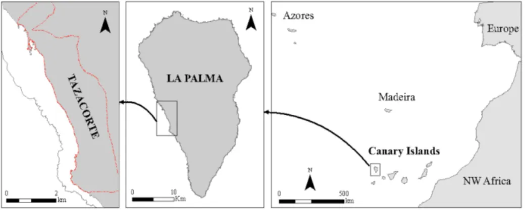
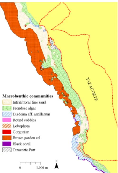
GEOGRAPHICAL INFORMATION SYSTEMS (GIS) AS A TOOL FOR THE ENVIRONMENTAL EVALUATION AND MANAGEMENT OF THE COASTAL AREA OF TAZACORTE, LA PALMA (CANARY ISLANDS, SPAIN)
L.M. García, C. Sangil, L. Concepción, R.F. de León, J.B. Diez & I.Y.G. Rodríguez
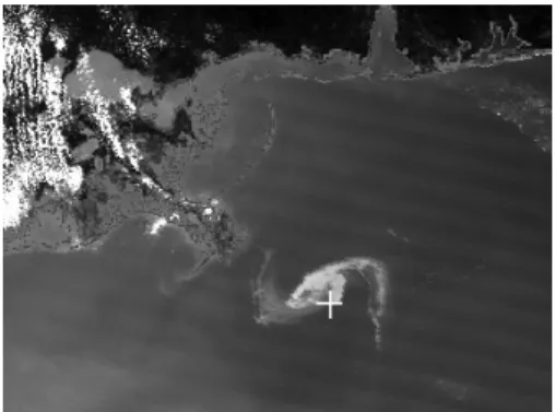
EVALUATION OF MODIS DATA FOR MAPPING OIL SLICKS - THE DEEPWATER HORIZON OIL SPILL CASE (2010)
M. Gianinetto, P. Maianti, R. Tortini, F. Rota Nodari & G. Lechi
SYSTEM APPROACH FOR COASTAL ZONE MANAGEMENT: APPLICATION IN SOUTHEAST COAST OF TERCEIRA ISLAND AND GUADIANA ESTUARY
M.H. Guimarães, A. Mascarenhas, C. Sousa, T. Dentinho & T. Boski
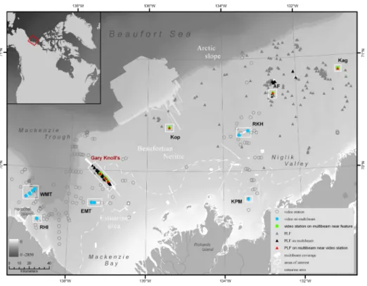
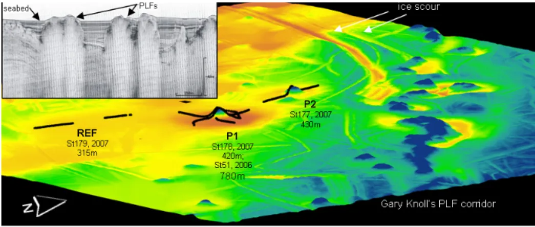
ANALYSIS OF EPI-BENTHOS DISTRIBUTION AND THEIR POSSIBLE ASSOCIATION TO GARY KNOLL’S PINGO-LIKE-FEATURES ON THE CANADIAN BEAUFORT SHELF: A SMALL-SCALE CASE STUDY
K. Jerosch, V.E. Kostylev & S.M. Blasco
GEOGRAPHIC INFORMATION TECHNOLOGIES FOR INTEGRATED COASTAL ZONE MANAGEMENT IN COLOMBIA: A NATIONAL EXPERIENCE
P. Lozano-Rivera, C. García-Valencia & A.L. Rodríguez
GOVERNANCE ISSUES FOR OCEAN SUSTAINABILITY: APPROACH TO AZOREAN MARINE JURISDICTIONS
L. Paramio
GIS APPLICATIONS IN MARINE RESOURCES MANAGEMENT: EXAMPLES OF SPATIAL MANAGEMENT MEASURES FROM BERMUDA
J.M. Pitt & M.L. Shailer
ASSESSMENT OF WATER-LOGGING EXTENT USING RS AND GIS TECHNIQUES AND ITS POSSIBLE REMEDIAL MEASURES AT THE KOPOTAKSHO BASIN AREA, BANGLADESH
S. Rahman, S.H. Rahman & Md.W. Ullah
IDENTIFICATION OF MARINE IMPORTANT BIRD AREAS IN PORTUGAL
I. Ramírez, J. Andrade, A.Meirinho, P. Geraldes & B. Lascelles
DEVELOPMENT OF A METHODOLOGY TO EVALUATE THE FLOOD RISK AT THE COASTAL ZONE
P.D. Raposeiro, C.J. Fortes, M.T. Reis & J.C. Ferreira
DATA REQUIREMENTS AND TOOLS FOR MARINE SPATIAL PLANNING
K.A. Stamoulis
WORKING TOWARD A MULTIPURPOSE MARINE CADASTRE IN THE U.S. TO SUPPORT MARINE SPATIAL PLANNING
D. Stein, C. Fowler, C. Taylor, B. Smith & A. Bode
A PICTURE IS WORTH A THOUSAND WORDS-USE OF GPS ENABLED CAMERA IN GEOSPATIAL MAPPING
A. Wadwani
ECOLOGICAL ASPECTS OF BRINE DISCHARGE INTO SHALLOW BRACKISH BAY - A CASE STUDY OF PUCK BAY, BALTIC SEA
Book Chapters
10
15
23
31
38
46
53
61
68
78
86
94
103
112
120
129
138
148
155
158
ABSTRACT
There has been a crescent interest on the scientific, cultural and socio-economical value of the Azorean hydrothermal vents by the Regional Government that has sparked the public interest on these unique ecosystems. The Azores are a privileged region in what concerns hydrothermal systems since it is possible to find most ecological variants of these systems in close proximity (from terrestrial hotsprings to deep-sea vents, passing by shallow marine vents). The shallow marine thermal ecosystems are subject to higher human pressure than their deep-sea counterparts due to their close proximity to the islands. However, at present time, it is the deep-sea Azorean thermal sites that possess a more coherent protection status (Menez Gween and Lucky Strike) since they are considered SAC under the Habitats Directive. Among the shallower vent sites only D. João de Castro hydrothermal vents field is under protection status due to the ecosystem itself (SAC). A revision and a comparison of the protection status of the nine shallow Azorean marine hydrothermal vent sites are here discussed.
Index Terms - Hydrothermal vents; Azores; sustainable development; MPAs
1. INTRODUCTION
The Azores Archipelago is a rich area in hydrothermal vent habitats. Within close proximity it is possible to find not only terrestrial but also several marine hotsprings. Further more, the marine hotsprings environments span from the shoreline to deep-sea vents.
According to the areas defined by the Azores Regional Network of Protected Areas [1] all Azorean shallow marine
vent sites should be considered within the Island Park delineation, with the exception of the hydrothermal vent fields at D. João de Castro Seamount that fall within the Azores Marine Park domain.
Unfortunately, not all shallow vent sites were included within the Island Park, and in the cases in which they were included such was not done with the goal of protecting the hydrothermal ecosystem itself. The later resulted in a protection status miscellaneous that should be reviewed in order to obtain the same conservation status and management level for all shallow marine hydrothermal sites across the archipelago.
On other hand, the protection and conservation status of Azorean deep-sea vents is better defined since two of the three Azorean deep-sea hydrothermal vent filed areas (Menez Gween and Lucky Strike) are classified as SACs [2] within the context of the European “Habitats directive” framework.
2. SHALLOW MARINE VENTS IN THE AZORES
There are a total of nine shallow marine hydrothermal vent sites identified within the Azores Archipelago (Table I). Some of these areas are characterized by an intense degasification in addition to a moderate to high thermal anomaly. One can find the highest variety and number of shallow hydrothermal sites near S. Miguel Island, in the eastern islands group. The western shallow hydrothermal site is found at Flores Island shoreline and is known as Lagedo hostsprings.
SHALLOW HYDROTHERMAL VENTS AND MARINE
PROTECTED AREAS WITHIN THE AZORES ARCHIPELAGO
P. Aguiar & A.C. Costa
Research Center in Biodiversity and Genetic Resources (CIBIO-Azores), University of Azores, Ponta Delgada, Portugal. E-mail: [email protected].
Contrarily to the deep-sea hydrothermal vents protected areas none of the protection levels established for the shallow marine hydrothermal sites were acquired in order to value and protect the hydrothermal ecosystem it self. Even in the case of the hydrothermal vents located at the D. João de Castro seamount the SAC status was attributed primarily according to the habitat category of Reef [3] and only afterwards it was also classified within the other type of sensitive habitats under the “Submarine structures made by leaking gases”.
The shallow marine hydrothermal sites of Lagedo (Flores), Carapacho (Graciosa), Ferraria (S. Miguel) and Ladeira da Velha (S. Miguel) were previously classified as IBAs [4-6].
In Faial Island, the Espalamaca degasification low temperature hydrothermal field is also integrated in a larger protected area designated Baixa do Sul (Canal Faial-Pico) recently classified as a SAC and integrated in the PNIFAI within the sector FAI010. The marine hydrothermal site of Varadouro, also in Faial Island, is located right at the shoreline near the Varadouro village, immediately on the outside limit between two protected sectors of the PNIFAI [7]. Ferraria, Mosteiros, and Ladeira da Velha/ Porto Formoso on S. Miguel Island, as well as Espalamaca (Faial) are classified as Protected Areas for Resources Management within the framework of the respective Island Park premises [6-7]. Carapacho (Graciosa) and Lagedo (Flores) are classified as Protected Areas Table 1 - List of all shallow marine hydrothermal sites within the Azores Archipelago with island location and protection status.
for Habitat or Species Management [4-5]. Varadouro is outside Faial Island Park limits and Ribeira Quente is also not included within S. Miguel Island Park limits [6-7].
According to the present legislation minerals or other geological extractions are either forbidden or conditioned according to a previous technical appreciation at Carapacho, Ferraria, and Ladeira da Velha. Scuba diving touristic activity is also done under specific conditions, after technical approval, at Ferraria [5-6]. It is not clear for the other shallow marine hydrothermal sites which are the use restrictions for its utilization. Such guidelines are essential tools and need to be added to the management plans for all these areas.
3. UNIQUE ECOSYSTEMS
The diversity gradient between the shallow marine hydrothermal ecosystems and the surrounding “common coastal marine environment” is very steep. The unique microbial communities at these sites form vast microbial mats that blend with sea-sponges and algal cover at the ecosystem limits. This biological mixture of two worlds results on a unique ecosystem powered by the two types of primary production on Earth (based on solar energy- photosynthesis; and based on mineral energy- chemosynthesis). Such environmental constraints allow for the co-existence of a high variety of metabolisms and lead to the prediction of a higher microbial diversity at shallow marine hydrothermal sites when compared with the deep-sea microbial communities [8].
Comparatively to the deep-sea and to the terrestrial counterparts, the Azorean Shallow Marine Vents Ecosystem has not been the target of many ecological studies. However, it is possible to say, based on the existing publications, that this ecosystem has a distinct community patterns from the surrounding coastal marine environment even at the invertebrate community level [8-9] worthier of further studies.
4. SHALLOW HYDROTERMAL VENTS WITHIN THE AZOREAN SUSTAINABLE DEVELOPMENT CONTEXT
Given the present socio-economic settings the Azores Regional Government is keen on validation of the Azorean natural thermal resources as a mean to promote the archipelago sustainable development being on geothermal energy as a renewable resource or a motor for technical and touristic innovation and development.
4.1. Touristic development
Since early times the Azores are known for their “Caldeiras” and thermal waters. According with a few schollars Thomas Hicking was the first true thermal tourist at the archipelago [10]. Nevertheless the Azorean thermal waters (hydrothermal areas) start to be studied from the scientific perspective at the end of the 18th [11]. The exuberance of the warm
seawater near Carapacho or Ferraria was not left unnoticeable.
4.1.1. Wellness tourism
Historically some of these shallow hydrothermal sites have been explored for therapeutically purposes. In some cases there were thermal bath houses constructed within the hot springs vicinity (Varadouro, Carapacho, Ladeira da Velha, and Ferraria) [8, 10]. The decline of the patients number and the disbelief on the therapeutically properties of these hydrothermal sites lead to the closure of the thermal bath houses and to the lack of specialized medical doctors within this field.
Recently, the public demand for alternative natural treatments as well as for the wellness-spa tourism increased and sparked the investment on this sector. Ferraria, Carapacho, and Varadouro thermal bathhouses were or are being recovered as well as the hydrothermal fluids caption systems for the thermal fluids adjacent to these areas. The sustainable exploitation of
such hydrothermal resources within the wellness tourism may lead to an economical and social improvement however it demands an investment on scientific knowledge of the fluid chemistry but has so far lacked on the biological and ecological contextualization for such areas. In order to better promote a sustainable use this resources it would be necessary to develop special management plans for this area that emphasis the maintenance of the hydrothermal ecosystem equilibrium.
Related to this sector, even though not directly, is the usage of marine hydrothermal fluids and “hydrothermal sand” and/or “mud” for cosmetic treatments [12, 13]. In this case the study of the thermal microbial communities and their end products are studied and in some cases recreated in controlled environments in order to mass produce exfoliating or hydrating products just to name a few, that than can be used in treatment spas as well as at the comfort of our homes. Such environmental mining of organisms from these ecosystems may have small impact on the ecosystem itself at the time of the sample extraction. In this case the protection and management measures should be implemented to guarantee that a percentage of the profit of the eventual mass production of these resources reverts for the local community development.
4.1.2. Eco-tourism
The constant search for new touristic products to offer within the Azores will eventually lead to a higher number of scuba diving touristic operators offering a “dive within the Azorean natural champagne”. While such offer may increase people’s awareness of the uniqueness of such habitats will also increase the human impact at the sites. The close proximity to the shoreline as well as the shallow depth at which most vents are found increases the vulnerability of theses unique ecosystems. The geological degasification structures are a unique site mingled with the remaining biodiversity of the Azores subtidal marine
system. Thus far only Ferraria has a level of protection that refers usage restrictions for scuba diving activity. It would be necessary to promote good practices among touristic diving operators that may offer this product as a way to preserve the habitat equilibrium without compromising the region sustainable development. In addition it would be important to determine a carrying capacity for each shallow marine vent site to facilitate management measures and to cause the least impact possible.
4.2. Biotechnological development On the last decades quite a few companies specialized on screening for marine organisms enzymes. This type of mining is once more a low impact activity when it is carried on by knowledgeable personal. The need for protection status and management measures in this sector are not necessarily to maintain the ecosystem integrity but mostly to guarantee and promote a regional sustainable development trough the balanced exploitation of such natural resources. The seas cover 70% of the planet earth. The oceans comprise a wide range of ecosystems and habitats that harbor a large biological diversity that may equal a large chemical and genetic diversity. Less than 1% of all marine microorganisms has, thus far, been successfully cultured and therefore offer a unique opportunity to find new enzymes. Last estimates from marine biotechnology indicated that it was worth $2.48bn year. Extreme marine ecosystems enabled the biology to evolve and adapt to high/low temperature (e.g. hydrothermal vents – superheated water); high salinity and even high pressure to name a few characteristics, the Azorean shallow marine vents are no exception [14] and together with the Azores deep-sea and with the terrestrial hydrothermal vents can be a pivot on the biotechnological development of the region.
Besides the enzyme mining it is necessary to better understand the biogeochemical cycling of these systems since the hydrothermal fluid mineral
nucleation or mineral concentrations is many times carried on not by a single microorganisms but by a natural consortia that catalyzes the minerals deposition [13].
5. UNIFYING CARACTER
The long Azorean thermal heritage was reflected on a recent census conducted at S. Miguel Island from which it is possible deduct that Azorean society values the preservation and management of their hydrothermal areas specially the shallow marine vent fields and recognizes that they need to be better protected from a conservation status perspective in order to promote a sustainable development. The main value attributed to these hydrothermal systems is related to their unique geological features paired with the mineral depositions integrated in the both touristic sectors reported above. Less people are aware of their high economical value within the biotechnological context [15].
There is no doubt that the Azorean hydrothermal systems are of high level of importance for the Azores Regional Government and that this class is aware of its importance in the biotechnological market. Their protection status is however confusing at this stage with a higher protection level for deep-sea vents hydrothermal sites that due to their location are less impacted, than the protection settings for shallow marine vents, whose location near the islands shoreline put them in at higher vulnerability risk. Ferraria and Ribeira Quente, followed by Carapacho are the best known shallow marine hydrothermal sites near shore [15]. Unfortunately, Ribeira Quente hydrothermal vent field is not included within any reserved or protected area of S. Miguel Island Park [6] at present. By other hand, the current shallow hydrothermal fields were not purposely included in the Island Park protected areas, which resulted in a status miscellaneous that needs to be reviewed in order to obtain the same conservation status for all shallow marine vents across
[13] Câmara J., J. Medeiros, and P. AGUIAR, “Estudo comparativo da composição química de lamas e biofilmes termais das Furnas” in Actas do Encontro Internacional de Termalismo e Turismo Termal e III Fórum Ibérico de Águas Engarrafadas e Termalismo p.419-424, 2009.
[14] Aguiar, P., C.L. Pereira, C.M. Loureiro, and L. Amaral-Zettler. Bacteria communities at shallow marine thermal vents within the Azores archipelago at the light of the 454 V-tag pyro-sequencing. ICoMM Spring meeting Actas, Woods Hole, MA, EUA. 2009
[15] Gaspar C., H. Cabral, J. P. Raposo, T. Sousa, and P. Aguiar, “Nascentes Termais e o seu significado na cultura Açoriana”, Actas do Encontro Internacional Termalismo p.431-436, 2009.
the archipelago. If the protection level was given to the ecosystem itself a base line management policy could be more easily implemented as for example for the Transylvania hydrothermal vents SAC [3]. As a stepping-stone in this process we propose the development of a geo-referenced layer with general ecosystem information on all shallow marine vent sites within the Azores archipelago. 6. REFERENCES
[1] Decreto Legislativo Regional nº15/2007/A from
[2] Addendum to Directiva Habitats nº92/43/CEE (2009/1001/UE) from 22 December 2009
[3] Directiva Habitats nº92/43/CEE from 21 May 1992
[4] Proposal for Flores Island Park by Decreto Legislativo Regional- waiting approval
[5] Decreto Legislativo Regional nº45/2008/A from 05 November 2008 [6] Decreto Legislativo Regional nº19/2008/A from 08 July 2008
[7] Decreto Legislativo Regional nº46/2008/A from 07 November 2008 [8] P. Aguiar, Microbial ecology of Azorean hotsprings as revealed by culture and Molecular techniques, Portland State University, Portland, OR, 2005.
[9] S. P. Ávila, Processos e padrões de colonização e dispersão dos Rissoidae (Mollusca: Gastropoda) dos Açores. PhD Thesis, University of the Azores, Ponta Delgada, 2005.
[10] Motta de Sousa, J. M. O Vale das Furnas. Almedina. Coimbra, 2008. [11] Mosely, H. N., “Notes on freshwater Algae obtained at the boiling springs at Furnas, St. Michael’s, Azores, and their neighbourhood”, J Linn Soc Botany nº 14, pp.321-325, 1874
[12] Quintela A., S.F.P. Almeida, D. Terroso, E. F. Silva, F. Rocha, and V. FORJAZ, “Microalgas colonizadoras de Lamas Vulcânicas Açorianas Durante a Maturação”, Actas do Encontro Internacional de Termalismo e Turismo Termal e III Fórum Ibérico de Águas Engarrafadas e Termalismo p.329-336, 2009.
ABSTRACT
North western Mediterranean is characterized by a high fishing activity and consequently, the awareness to preserve and protect high ecological important areas has been recently on the scope. Cape Creus is lately being subjected of study in order to assess its values in the frame of European Directives. By combining existing data of artisanal fisheries’ components together with gathered seabed components, a spatial distribution of fishing activity is pretended. A spatial approach has been the main tool when assessing the consistency of fishing pressure onto the seabed. Benthic communities seem to be more affected when overlapping of fishing types occur. Consequently, alternating parceling and seasonal closures among fishing gear types, to minimize the impact onto benthic communities as also setting no-take zones is strongly suggested. The establishment of a MPA in the near future has to be seen for all stakeholders as one step contributing to the sustainability of the ecosystem, once the potential impact of this fishing activity is shown. Mid-scale benefits by means of reducing fishing pressure in the area will enhance both alternative income solutions and spillover offset as a result of habitat recovery. Keywords: métier, GIS, fishing spatial activity, MPA, fisheries management.
INTRODUCTION
European directives are strongly encouraging to increase the number of marine protected areas in each European country. MPAs have been envisaged not only as a potential tool for conservation
but also as safeguard against most fishing practices, either commercial or recreational, as for tourist attractions; which all together contribute to the decline of biological resources [3]. Cape Creus area is currently being studied in order to evaluate its potential ecological value to become the first MPA offshore from the
1LIFE+Indemares Project, in the frame
of the Habitat Directive and Natura 2000 Network as well as the 2Biodiversity Law
at the national level. In order to define a first step on the fisheries’ domains in Cap de Creus, an instrumental study pretends to be done by taking advantage of the stocktacking conducted by the FAO-COPEMED Project. Fishing activities increasingly participate in habitat destruction, accidental mortality of non target species, changing functioning and structuring of ecosystems and causing evolutionary shifts in the demography of populations [12]. A direction towards the participation of all stakeholders in fisheries management needs to be taken; worldwide, fishing is affecting the seabed habitat on the continental shelf [10]. The fishing behavior in space and time resulting in a particular area will mark off the habitat impact in a patchy distribution; likewise, levels of disturbance vary among habitat types as a result of fishing intensity and frequency [10]. It is clear that any fishing gear will disturb the sediment and resident community at some degree but not all fishing methodologies affect habitats in the same way. Bottom-fishing activities involving mobile fishing gear have a physical impact on the seabed and the biota living there [10]. Consequently, it is important to know the intensity of the disturbance which will depend on used gear, sediment type and water depth [10].
SPATIAL ASSESSMENT AND IMPACT OF ARTISANAL
FISHERIES’ ACTIVITY IN CAP DE CREUS
A. Purroy
1, S. Requena
1, R. Sardá
2, J.M. Gili
1, E.Serrao
31 Institute of Marine Sciences, CSIC (ICM-CSIC). Passeig Maritim de la Barceloneta, 37-49.
E-08003, Barcelona (Spain), E-mail: [email protected]
2 Centre for Advanced Studies of Blanes, CSIC (CEAB-CSIC). C/ d’accés a la Cala St. Francesc,
14. E-17300, Blanes (Spain)
3 Universidade do Algarve. Campus de Gambelas P-8005-139, Faro (Portugal)
“This work was presented by the first author in order to complete the requirements to achieve the degree of Master of Science in Marine Biodiversity and Conservation, within the ERASMUS MUNDUS Master Programme EMBC”.
habitat conservation; thus, achieving a well understanding of key communities and fisheries’ distribution is a first step for an integrated management with the main stakeholders, the fishermen.
By taking advantage of the stocktaking of the main fishery components associated with artisanal fisheries, a compilation with other existent regional information from the area is intended in order to find out the main goal. GIS software has been used as the main tool aiming to obtain the most complete conception of the spatial fishing activity in Cap de Creus and to assess the incidence of gears on an unprotected ecosystem. The focus on determining the degree of impact of certain areas according to the coexistence of one or more fishing gears will serve a priori to assess the vulnerability of the existent community types. There is expectation in the relationship between outstanding communities and less exploited areas. MATERIAL & METHODS
Study area: Cap de Creus
Historically, Cap de Creus has been the first maritime-terrestrial park to be established in Spain in 1998, representing the marine domain in a 22% [11]. Even if the protection figure is already existent, it is intended to extend the protected area to offshore waters comprising shelf, shelf-break and canyon. By considering the depth gradient, a more complete scheme of the system can be offered.
Cap de Creus canyon is the western canyon of the conspicuous underwater canyon system found in the Gulf of Lions. It is an area of complex bathymetry and very nutrient rich from the outflow of several rivers (Rhône River from Gulf of Lions, and the local rivers Ter, Fluvià and Muga). It starts at the continental shelf at about 90-100m depth and it extends up to 5Km off the coast (42°18’49.202 N – 003°34’ 6.000 E). The canyon is oriented northwest-southeast giving a V-shape structure breaking into the open sea. In total is about 95Km long and presents a maximum depth of 2150m.
Accordingly, an approach throughout the spatially definition of fishing activities and their overlapping will serve to value the existent communities’ status. Thus, this is an essential tool to be taken into consideration when analyzing the proposed area to be protected.
In order to define the real effort invested in a resource, artisanal fisheries are defined by combining fishing arts, target species, fishing geographical zones and seasonality, the concept of métier is applied [6]. The Mediterranean is characterized by a high diversity of fishing gears and target species; artisanal fisheries are mostly coastal owing boats with a maximum size of 12m and small capital investment [4]. The EU Mediterranean fleet is represented in an 80% by artisanal fisheries [5]. From the point of view of fisheries exploitation, the continental shelf and the shelf-break are the most interesting areas where most of the resources can be found. Coastline and continental shelves host wide range of habitats. Most types of artisanal fisheries extend from the coastline onwards into the continental shelf, decreasing in their frequencies as distance and depth increase [7]. Fishermen’s local knowledge determines seasonality in relation to species behavior and its abundance along the year [15].
The use of GIS tools is often used to account for spatial predictions [15, 9]. In here, an approach to assess vulnerable and less damaged communities combined with spatial coincidence in time of fishing gears has been done.
OBJECTIVES
When studying marine areas for conservation purposes, one of the main objections is to localize the anthropogenic pressure exercised in the area. Fishing tradition has distinguished this area since the old times; however, during the last decades fishing pressure is an evident fact. Just like in other fishing regions in Europe, the Mediterranean faces the problem of reconciling the economic activity with sustainable fish stocks and
Winds are strongly a limiting factor in this area. Their high frequency and intensity mark the fishing activity in Cap de Creus which preclude going out in the sea. North from Cape Creus northerly winds dominate the scene along with the rough conditions from the Gulf of Lions, especially during winter season. The so-called Tramontane and Mistral winds (northwest and northern winds respectively) are characterized to be the most frequent, strong, dry, cold and reaching persistences up to several days [14]. In turn, the noted episodes of vertical water mixing along the coast are responsible of the water nutrient enrichment. In Gulf of Roses, Tramontane and south-west and western winds dominate the area, whereas heading south winds lose their intensity.
Regarding the substrate, variability along the coastal region is clearly observed. It ranges from rocky, dark and high coast to lower coast areas. Sandy and muddy bottoms seem to dominate the area, however a mixture of sandy and muddy bottoms as also gravel and rocks complete the substrate composition. In addition, protected seagrass beds can be found on those coastal areas where well-conserved communities of Posidonia oceanica are developed. The southern part of the canyon, in front of Roses Bay, is the broadest and most extensive part of the shelf due to river deposition processes. Underwater canyons present many areas acting as deep reefs, in where many species form structures where others find refuge. High abundance of corals are present in the rocky bottoms whereas in the deepest parts Maërl beds abound (concentration of species of calcified red seaweed), commonly associated to a high diversity of sessile species. In other cases in the Atlantic has been seen how deep cold corals are an ideal habitat for juvenile and larvae of several fish species. Many of these species have a high commercial value, thus acting again as a refugee from fishing pressure, by allowing the recovery of stocks in depletion. The high regime of currents mentioned above allows the high concentration of particles in the water The Liguro-Provenzal-Catalan current
(aka Northern Current) from the Gulf of Lions, the input from the above mentioned rivers together with strong dominant north winds causing water mixing, make of this area a highly productive zone. Consequently, it is an area conducive to the agglomeration of pelagic fish among others.
The presence of free water currents coming from the Gulf of Lions collide with the outstanding Cape Creus causing its displacement from the coast and allowing littoral currents between this and the coast. Another phenomenon is the deep convection occurring in winter when a maximum in surface salinity combined with strong, cold and dry northerly winds and a cyclonic circulation, known as the Western Mediterranean Deep Water formation [14]. This process produces dense water which sinks to the bottom as a section of newly formed deep water. The cascading effect is been reported as an alternative mechanism to deep water formation in the northern Catalan Sea [8]. Ulses et al. (2008) [16] refer to water cascading and to marine storms as two mechanisms responsible of regulating shelf-slope exchanges causing downwelling to submarine canyons. During winter, the cooling from northwesterly winds destratify and increase in density water from the shelf enabling the plunging down the slope. The current system along the Gulf is strengthen and accelerated by the wind, receiving the south westernmost part of the Gulf, the highest intensity. In this extremity, the narrowing of Cap de Creus shelf together with the offshore limitation by Cape Creus Canyon, result in a larger acceleration of currents. A well-figured simulation of currents in the area can be found in Ulses et al. (2008). The spreading of continental influence on waters is preferred for spawning as shown in studies with anchovy by Salat (1996), coinciding with the water stratification period in spring and summer, which otherwise would be nutrient poor.
location of fishing gears and the related items. ArcView and ArcCatalog 9.3 GIS (ESRI Corp., Redlands, California) software in combination with the Spatial Analyst extension has been used to spatially distribute the data and to obtain the resulting maps.
Data structure and analysis
All the information used in this case study has been obtained from public sources and institutions.
In order to frame the area of interest based on the available information, a fishnet of 500x500m square cell (0.25 Km2) has been created. The fishnet has been set over the study area and those grids associated to the inland part have been deleted, thus containing each grid associated qualitative marine data. The result obtained is a 4581-cell grid covering a surface area of 1145.25 Km2. This methodology has been recently used to merge sparse data to map bird communities [3] or to mark out the boundaries of MPA in the Mediterranean [14]. Cell grids provide harmonization and reduce the complexity of spatial datasets, particularly when combined, due to each cell has a unique cell code identifying resolution, row and column.
Information processing:
Adaptating available existent layer files in order to convert those using GIS extensions and applications to suit to the fishnet of study. Geoprocessing tools (Spatial joining, merging, dissolving and clipping) have allowed fusing and combining the information ensuring that each cell grid encloses each feature. The selecting tool from the attribute table has permitted to map for each of the selected variables in study.
Coverage layers referring to bathymetry, substrate and bionomy have been provided by CSIC scientists who had previously created these layers for other projects.
Layers referring to Coastline, European rivers, ports and others have been obtained from available European and regional sources (such as DARP – Department of Agriculture & Fisheries). column, serving to feed many organisms.
Additionally, cetacean species are also associated to underwater canyons such are finback whales and bottlenose dolphins and striped dolphins.
Topography of the area is already very precise but biology still needs to be defined. Due to the previous projects HERMES (UE) and DEEP CORAL (National Project), a bioprospection from Cap de Creus canyon has been done. However, a deeper study on the ecology and biology will allow establishing more adequate protection measures. By using ROV and manned submergible vehicle images, a high abundance of cables and abandonment fishing gears has been detected showing the impact of fishing activities in the area. It is known that the past trawling activity destroyed many areas on the continental shelf and slope; this is supported by the presence of surviving species in similar habitats, which are known to be in unreachable areas, far from the fishing pressure. The impoverished mud communities in the continental shelf might be a consequence of: i. major activity of bottom trawling by boats, ii. instability of the substrata which is mainly composed by carcasses of bivalves and detritus, together with the slope of the area make colonization and settlement of sessile species even harder [11].
Data collection
The information regarding artisanal fisheries in Cap de Creus was obtained throughout questionnaires circulated around fishermen in the area of Catalonia between December 2000 and March 2001 by the regional FAO consultant. The surveys consisted in interviewing either the majors or the secretariat of the fishing guilds and fishermen representing the main métiers in the area in order to fill in a sheet for each of them. The use of surveys to the fishing communities has been seen in other studies [13, 9] to provide a good assessment for fisheries. Spatial structure
by excluding thus, minor gears. The added values can then be ranged from 0 to 4. The lack of fishing gears detected in an area obtains the value of 0, for those areas where only one fishing gear acts 1 is the given value, when two of the gears overlap get a value of 2, and when up to three of the fishing gears coincide the rating is 3. A value of 4 has not been obtained meaning that in any area the confluence of all arts has been recorded. The resulting map reflects the limitations in the coexistence of particular fishing types, i.e. trammel nets and longlines hardly coincide due to the incompatibility of their fishing methodologies.
Key communities
Once the spatial distribution of fishing types and the value regarding the degree of impact of such activities have been set, it was time to assess the local communities. The existent major communities to preserve include coral reefs, sponge gardens or maërl beds (calcareous algae) as other hard substratum communities. DISCUSSION
To protect not only species but also communities there is a need to know those habitats exposed to more exploitation than others. In this study one can see how the seabed experiences different levels of fishing activity; those areas subjected to a greater effect correspond to areas relatively undisturbed by natural perturbations (i.e. muddy areas) unlike areas suffering of high environmental influence with unconsolidated sediment being predominant. It is important knowing the benthic characteristics to ensure that fishing closures in no-take or partially protected areas do not cause a displacement to other vulnerable areas. An opportunity for protection of particular areas where ecologically important species have been recorded is by taking into consideration spatial distribution when managing.
The partition of fishing activities is an effective approach for habitat conservation. Both, areas used The coordinate reference system
employed is the Universal Transverse Mercator (UTM), UTM zone 31, using the World Geodetic System 84 (WGS84) as the geodetic datum for storage and analysis.
RESULTS
A complete map has resulted from combining layers with the data regarding type of substrate (bottom quality), bathymetry and fishing zone. Consequently, each cell grid contains a value attributed to each characteristic, allowing their combination for a spatial scale. The resulting spatial distribution for each fishing gear type acting on the area of Cap de Creus has been obtained by using a total number of 73 métiers. Accordingly, the composition of artisanal fisheries’ gear in the Mediterranean is commonly dominated by trammel nets gillnets and longlines as also seen in other studies [2]. The use of one versus the other may vary with the fishing season, target species’ behavior and particularly in this area, due to the environmental conditions; hereby, the provided data by métiers is considered to be more accurate when spatially distributing their action of activity because it encompasses the local tradition. Notwithstanding, to generally assess the potential influence for each type of gear, the métier concept has been eventually grouped when visualizing the results. Because the purpose of study pays particular interest in analyzing the offshore part of the area of Cape Creus and in more detailed the proposed area to protect from the LIFE+Indemares Project, a focus in the already known key communities has been made, as the most well conserved, representative and emblematic communities.
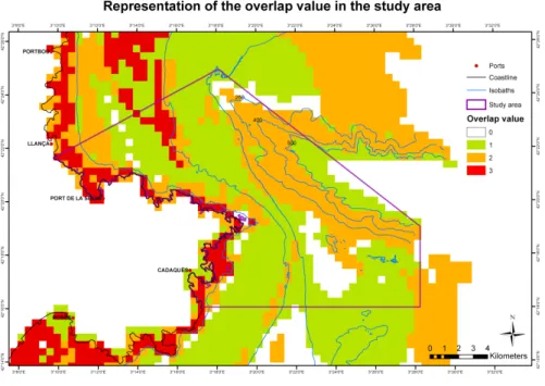
Overlap value
An overlap value has been set to define the coincidence in space of two or more fishing gears and to detect the degree of impact over the system (see Figure 1). Only those gears previously considered as acting in a broader scale over the area of study for protection have been considered
the existence of activity of three gear types. Therefore, there is a relationship of well-conserved communities and the incidence degree of fishing activities. Because of the extent of fishing activities in the local economy and the urgency in protecting certain marine habitats and species, MPA planning and management should be conducted on a multidisciplinary basis [1].
CONCLUSION
This study is intended to be an approach for artisanal fisheries; however, for more concise results regarding global fishing activities, such vessel monitored system data (VMS) to assess fishing by semi-industrial and semi-industrial fleets should be recovered. Notwithstanding, it is important to note that most of the semi-industrial fleet move away from Cape Creus, off to waters from the Gulf of Lions. In addition, environmental (i.e. currents), socioeconomic (i.e. type of fishing gear) and geophysical (i.e. narrowness of the shelf) components in the area, make of artisanal fisheries the prevailing activity. There is an ongoing need to review artisanal fisheries in the Mediterranean through recurring debates on the future status of fisheries. Bearing in mind that data used for this case study was collected between December 2000 and March 2001 and that fishing activity’s consequences are observable on a large-scale, continuous monitoring must be highlighted in order to promote a responsible development respecting both the environment and fisheries.
Conservation needs to be seen from a more integrated and proactive perspective, assuming the relation of protected spaces with the surrounding territories and with human uses. Looking for coherent ways of territorial ordination will keep the functions and natural services. Involving local communities in taking the most profit of the economic potential of MPAs needs to be highlighted when planning with stakeholders [1].
exclusively by unique fishing gears (i.e. parceling) or areas shared seasonally by two or more participants (i.e. considering target species’ behavior) have seen to work and to avoid conflict among the several sectors [10]. Thus, this is an excellent consideration when managing areas where ecologically important species have been recorded, to ensure their protection and the sustainability of the ecosystem. This seems to work well for benthic communities; nevertheless, to fully protect mobile species and their habitats it is urgent to identify the so-called Essential Fish Habitats, which not only encompass areas for nursery and spawning, but areas as relevant to keep up other stages of their life cycles such are food or predator avoidance sites [10]. A spatial overlap implies a greater impact onto the carrying capacity of the system and an impoverishment in the seabed. This reflects the degree of impact that destructive gear cause over habitats. Contrarily, by analyzing those areas with less confluence of different fishing gears, one can see a higher abundance of key communities for protection. Some benthic communities characterized by providing abundant biogenic structures are considered rich epifauna and thus as target species for conservation [10]; these include coral reefs, sponge gardens or maërl beds (calcareous algae) as other hard substratum communities. These communities are most well-conserved, representative and emblematic. In Cape Creus, cold coral, brachiopoda, ceriantharia, pennatulacea, gorgonians, sponges and detritic littoral sandy mud habitats are the key communities known up to date (see Figure 2).
When comparing bionomy and overlap value maps, it is seen how areas with higher ecological interest coincide with less overlapping of fishing gears, with values ranging from 0 to 2. The percentage of coverage of either one or none type of fishing reach a 60%, the confluence of 2 fishing gear correspond to 29% whereas only an 11% of the major area of study from the LIFE+Indemares Project shows
profondes 215:165-189
[10] Forcada A, Valle C, Sánchez-Lizaso JL, Bayle-Sempere JT, Corsi F (2010) Structure and spatio-temporal dynamics of artisanal fisheries around a Mediterranean marine protected area. ICES Journal of Marine Science 67:191-203
[11] Kaiser MJ, Collie JS, Hall SJ, Jennings S, Poiner IR (2002) Modification of marine habitats by trawling activities: prognosis and solutions. Fish and Fisheries 3:114-136
[12] Orejas C, Gili JM (2009) Caracterización física y ecológica de la franja costera, plataforma continental y cañón submarino de Cap de Creus, Spanish Council for Scientific Research [13] Pikitch EK, Santora C, Babcock EA, Bakun A, Bonfil R, Conover DO, Dayton P, Doukakis P, Fluharty D, Heneman B, Houde ED, Link J, Livingston PA, Mangel M, McAllister MK, Pope J, Sainsbury KJ (2004) Ecosystem-Based Fishery Management. Science 305:346-347 [14] Requena S (2009) Georeference compilation of information for the identification of possible SPAMI’s in the Mediterranean areas beyong national jurisdiction. Regional Activity Center for Specially Protected Areas (RAC/SPA) UNEP, Tunis
[15] Rocha F, Gracia J, González ÁF, Jardón CM, Guerra Á (2004) Reliability of a model based on a short fishery statistics survey: application to the Northeast Atlantic monkfish fishery. ICES Journal of Marine Science 61:25-34
[16] Salat J (1996) Review of hydrographic environmental factors that may influence anchovy habitats in northwestern Mediterranean. Scientia Marina 60 (Supl.2):21-32
[17] Stelzenmüller V, Maynou F, Martín P (2007) Spatial assessment of benefits of a coastal Mediterranean Marine Protected Area. Biological Conservation 136:571-583
[18] Ulses C, Estournel C, Bonnin J, Durrieu de Madron X, Marsaleix P (2008) Impact of storms and dense water cascading on shelf-slope exchanges in the Gulf of Lion (NW Mediterranean). Geophysical Research 113
REFERENCES
[1] Badalamenti F, Ramos AA, Voultsiadou E, Sánchez-Lizaso JL, D’Anna G, Pipitone C, Mas J, Ruiz Fernández JA, Whitmarsh D, Riggio S (2000) Cultural and socio-economic impacts of Mediterranean marine protected areas. Environmental Conservation 27(2):110-125
[2] Cadiou G, Boudouresque CF, Bonhomme P, Le Diréach L (2009) The management of artisanal fishing within the Marine Protected Area of the Port-Cros National Park (northwest Mediterranean Sea): a success story? ICES Journal of Marine Science 66:41-49
[3] Carboneras C, Requena S (2010) GIS Mapping of seabird distribution - A Pan Mediterranean perspective. 39th CIESM Proceedings, Venice, Italy 10-14 May 2010, Rapp. Comm. Int. Mer. Medit 39, p. 468
[4] Claudet J, Pelletier D (2004) Marine protected areas and artificial reefs: A review of the interactions between management and scientific studies. Aquatic Living Resources 17:129-138 [5] Colloca F, Crespi V, Cerasi S, Coppola SR (2004) Structure and evolution of the artisanal fishery in a southern Italian coastal area. Fisheries Research 69:359-369
[6] COM (2002) 535 final. Communication from the Comission to the Council and the European Parliament laying down a Community Action Plan for the conservation and sustainable exploitation of fisheries resources in the Mediterranean Sea under the Common Fisheries., Brussels
[7] Coppola (2006) Inventory of artisanal fisheries communities in the central and western Mediterranean. In: Department FF (ed) Studies and Reviews General Fisheries Commision for the Mediterranean 77
[8] Demestre M, Lleonart J, Martín P, Peitx JA, Sardà F (1986) L’Oceanografia. II. Recursos pesquers de la mar catalana, Vol 9. Diputació de Barcelona. Servei del medi Ambient, Barcelona
[9] Fieux M (1974) Formation d’eau dense sur le plateau continental du Golfe du Lion. Colloques Internationaux du CNRS sur la formation des eaux océaniques
Fig. 2 - Existent key communities in the study area from Cape Creus Fig. 1 - Overlap value in the study area from Cape Creus
ABSTRACT
Marine Spatial Planning for seabird protection requires identification of Important sea Bird Areas and, therefore, insight into bird distributions and status. Generally based on transect counts from ships, distribution maps can be built considering spatial patterns as well as bird-environment relationships. Balearic Shearwater May and October densities in the Portuguese Atlantic area were modelled using: geostatistical, multiple regression and regression kriging methods. While kriging reproduced the observed patterns best, regressions with environmental variables allowed better understanding of bird distributions, which could be related to batimetry, distance from coast, chlorophyll a and sea surface temperature. Regression kriging performed better than regression. Regression also enabled bird density prediction where and when observations were missing. Applications of our models to a vaster area and later time period, which constitute spatial and temporal extrapolations of the models, failed to reproduce important spatial patterns. Index Terms — seabirds, GLM, kriging, regression kriging, GIS
1. INTRODUCTION
Seabirds are the most threatened of all birds worldwide [1] and pelagic seabirds, which visit land only for short periods of time, are the least known, yet most representative of ocean ecosystems [2]. They are threatened by anthropogenic activities causing loss of feeding grounds
and prey, fisheries bycatch and oil spills within their foraging grounds and migratory routes [3, 4].
Recently, Marine Protected Areas have been extended to protect off-shore marine areas, instead of protecting only breeding colonies on land [2]. Marine distributions are, however, technically difficult to study and monitor, and highly variable, as birds are very mobile, occurring associated to dynamic habitat features like food availability. To understand and model seabird distribution, ecologically meaningful approaches are needed, such as the characterization of bird-habitat relationships, relating observed bird presences or densities to environmental conditions [5, 6]. The idea is to gain insight into the causes of distribution patterns, to be able to understand observed patterns and to estimate distributions for the extremely vast area that could not be sampled, or for other time periods or potential scenarios.
Multiple regression models have been used for this purpose, generally including oceanographic variables, such as water depth and distances to breeding colonies or the shore [6], and sea surface temperature and chlorophyll a concentration, which are considered useful proxies of water mass distributions, frontal systems, and ocean productivity [7], characterizing the oceanographic habitats of seabirds [e.g. 8, 6]. These regression models tend, however, to explain only a small part of the observed variability, suggesting that the model has an inadequate structure or complexity, or that it misses (unknown or unavailable) factors affecting species distribution. Part
EMPIRICAL MODELLING OF BALEARIC SHEARWATER
(Puffinus mauretanicus) CENSUS DATA FOR THE
PORTUGUESE ATLANTIC
A. Bio
1, A. Meirinho
2, I. Ramírez
2& P. Geraldes
21CIMAR/CIIMAR – Centro Interdisciplinar de Investigação Marinha e Ambiental, Universidade do
Porto, Rua dos Bragas 289, 4050-125 Porto, Portugal. Email: [email protected].
2SPEA – Sociedade Portuguesa para o Estudo das Aves, Avenida da Liberdade, nº 105, 2º Esq,
of the non-modelled variability may have spatial structure, or autocorrelation, which can be geostatistically modelled and used to improve regression predictions [9]. This method, generally called regression kriging, allows a better spatial estimation or interpolation for a sampled area, but does not allow predictions for non-sampled periods.
In the present study spatial and temporal patterns of Balearic Shearwater (Puffinus mauretanicus) distribution off the Atlantic Portuguese coast were assessed. Transect-observation data collected
in May and October were modelled with species-environment multiple regressions, through geostatistical analysis and through regression kriging, combining regression model estimates with the estimated spatial autocorrelation component of their residuals. Observed and modelled spatial patterns and bird densities were compared, considering the modelled time periods and sample sites. Regression models were further validated on an external data set, predicting bird densities for May and October of one year that had not been used for model building.
2. MATERIALS AND METHODS 2.1. Censuses
According to the International Union for the Conservation of Nature and Natural Resources (IUCN), the Balearic Shearwater, Puffinus mauretanicus (Lowe, 1921), is a Critically Endangered seabird which is endemic of the Balearic archipelago where it breeds [10]. In Portugal, this species occurs year-round with higher abundances during autumn/ winter and when migrating to their breeding territory [11, 12]. They flock mainly on the Atlantic coast between Figueira da Foz and Aveiro, and the area between Cascais and Cabo da Roca, occasionally forming groups of more than 1000 birds. For modelling, we considered May and October records, pooling data from 2005 to 2007. Predictions for the whole study area were done on 2008 data. Data were obtained from the Marine IBA LIFE Project [2], with surveys based on a modified version of Tasker’s
methodology [13], as recommended by the European Seabirds at Sea Group [14]. Data were collected in transects defined by a period of time (normally 5 minutes). All birds in contact with the water inside the pre-defined transect were counted, and birds in flight were counted taking regular snapshots to not over-estimate the density.
2.2. Environmental data and GIS To allow bird density estimations for the whole area of interest, we considered only variables available for that area: batimetry (courtesy of the Portuguese Hydrographical Institute), distance from the Portuguese coast, mean monthly chlorophyll a (CHLO) and mean monthly night-time sea surface temperature (SST) (Table 1). Sample CHLO and SST values were extracted from the mapped MODIS Aqua satellite level 3 products (http:// oceancolor.gsfc.nasa.gov), with cell-size of ~4x4 km, considering the respective month (May or October) and years (2005 Table 1 - Summaries of environmental data at the sampling sites, used for modelling, and those for the whole study area, used for spatial and temporal extrapolation. Mean values are given, with minimum and maximum values in brackets.
Fig. 1 - Sample semivariograms and fitted models for the May 2005/2007 Balearic Shearwater density records (Observations) and the GLM regression residuals (GLM res). to 2007). Bird density estimation for the
whole study area, covering 135 456 km2,
was carried out on May and October data from 2008. Environmental data were standardised and projected, and data and model results were compiled and mapped in ArcGIS 9.3, using Spatial Analyst and Hawth’s tools, a.o.
2.3. Data analysis
Spatial distribution of bird species was analysed modelling: (1) spatial gradients in the observed data through geostatistical kriging analysis (KRI) [15]; (2) bird densities in relation to environmental variables through multiple Generalized Linear Models (GLM) [16]; and (3) bird densities in relation to environmental variables and in terms of residual spatial autocorrelation, using Regression Kriging (RK) [17, 18, 19].
For the geostatistical analysis, isotropic and anisotropic (4 directions) semivariograms were computed to assess the spatial autocorrelation structure. Empirical semivariograms were modelled and these models used to estimate bird densities for the sampling sites using Ordinary Block Kriging, with 4x4 km blocks [20].
In the GLM regression, bird densities were related to environmental variables. Predictor variables were checked for normality; CHLO was log-transformed to approximate normality. The response variable, bird density/km2, was modelled
considering a quasi-Poisson distribution, which computed the appropriate dispersion parameter for our bird count data that showed many zeros and strong over-dispersion. We started with a model containing each of the predictor variables as a linear or first-order term (x) and as a quadratic or second-order term (x2), as well as all pair-wise first-order
interactions. Model terms were sorted according to their statistical significance in the model and the least significant term was eliminated. This process was repeated until all remaining model terms were significant (a= 0.05). Linear terms
were only removed after their respective quadratic terms, to keep the main effects in the models. Analogously, interactions implied inclusion of the respective variables (at least as first-order term). For the RK models, we standardized the GLM regression residuals and assessed their spatial autocorrelation through isotropic and anisotropic semivariograms. Spatially autocorrelated residuals were modelled and kriged and the kriging estimates were added to the regression predictions to obtain the final model prediction. A detailed description of the procedure has been published [9, 21]. Results were mapped in birds/km2 units.
All statistical analyses were done in R [22].
3. RESULTS
Only the May 2005/2007 data showed some spatial autocorrelation, allowing Block Kriging predictions for the sampling sites. The sample semivariogram was modelled with an isotropic spherical variogram, with nugget = 28.68, partial spherical sill = 16.97 and range = 2517 m (Fig. 1).
The GLM for the May 2005/2007 data included batimetry, distance to the coast, SST and SST2, CHLO and the interaction
terms between the distance to the coast and SST and between CHLO and SST. The model explained 39% of the deviance. Model residuals showed little spatial correlation. They were modelled with an isotropic spherical variogram, with nugget = 0.82, partial sill = 0.44 and range = 6203m (Fig. 1), and used for regression kriging.
Fig. 2 - Maps of Balearic Shearwater densities observed in May 2005/2007, and respective regression (GLM), kriging (KRI) and regression kriging (RK) predictions (we used few and equal density classes for better visualisation). Boxplots of observed (Obs.) and predicted Balearic shearwater densities, as well as model standard errors (SE) and variances (VAR); boxes show upper and lower quartiles, central lines mark median values, and 1.5 IQR Tukey whiskers as well the outlier points are given.
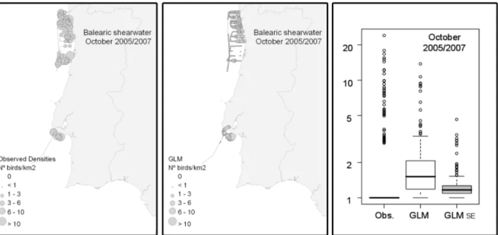
Fig. 3 - Maps of Balearic Shearwater densities observed in October 2005−2007, and respective regression (GLM) predictions (we used few and equal density classes for better visualisation). Boxplots of observed (Obs.) and predicted densities, as well as model standard errors (SE); boxes show upper and lower quartiles, central lines mark median values, and 1.5 IQR Tukey whiskers as well the outlier points are given.
![Fig. 1 - Aquaculture in Chile: annual production (tons) of algae, mollusks and fish between 1994 and 2008 (Source: Sernapesca [30])](https://thumb-eu.123doks.com/thumbv2/123dok_br/14964459.1005015/39.629.59.301.210.700/aquaculture-chile-annual-production-algae-mollusks-source-sernapesca.webp)