U
RBAN AND SPATIAL PLANNING IN
J
APAN
Marin TOMINAGA
A Master Course Student of Graduate School of Tohoku University, Department of Architecture and Building Science, [email protected]
Abstract. This paper aims to introduce the urban and spatial planning in Japan. According to the national planning system of Japan, chapter 2, the planning system has 3 administrative levels and each territorial region has its own regulation. This paper introduces especially about planning and regulation system in city region in Japan.
Key words: urban and spatial planning, Japan, land use, Master Plan
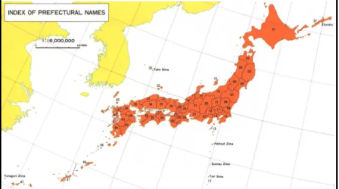
1. The prefectural governments and municipalities First of all, Japanese territory is divided
into 47 units called prefectural
governments (Fig.1). Each of them has its own administrative organization. The prefectural governments, differ from the municipalities which are locally based public organizations, in that they are concerned more comprehensively with a wider local area. Municipalities are the collective term of city (called shi), town (called machi), village (called mura), and
district (called ku which exists only in
Tokyo) and each municipality also has its own administrative organization. There are 786 cities, 753 towns, 184 villages and 23 districts in Japan (01/08/2011).
Fig. 1. Prefectural governments in Japan
2. The planning and regulatio n sy stem of Japan
2.1. The national planning system of Japan
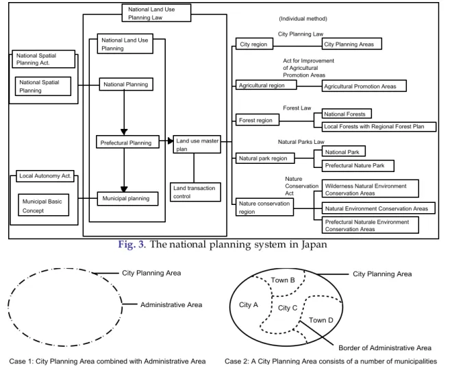
National Land Use Planning Law is a land use plan and also a regulation that aims to use the national territory comprehensively and systematically (Fig. 3). The law establishes National Planning, Prefectural Planning and Municipal Planning. The general plan for land use is as the basis for National and Prefectural Planning. The Prefectural Planning sets out five regions in each prefecture; a city region which is an area that needs to be developed and maintained as an integrated city, an agricultural region of which the primary concern should be to promote agriculture, a forest region which promotes the forest industry or maintains and enhances the variety of functions of the forest, a natural park region which has good natural scenery which should be preserved and its usage promoted and a nature conservation
region which has good natural
City Planning Law. The general plan functions to adjust the administrative division as the upper level plan of them.
2.2. The definition of city planning area
In 1919, a general idea called City Planning Area was brought in the City Planning Law in Japan. According to the operational guideline of city planning, there are the areas which need to be adjusted,
developed and maintained
comprehensively as a unified city and these are also the areas which are designated as the compass that can be sufficient to arrange the lands and facilities.
The specific definitions of City Planning Area are as follows; 1) it has 10,000 people in the municipality and 50% of the total
employed workers are involved in
commerce and industry or urban business categories, 2) it can be expected to meet the preceding issue of 1) in 10 years over the pace of development and the prediction of population and industry, 3) the central area of the target municipalities have over 3,000 of population, 4) specially good environment of the city needs to be developed in the city since it has resources for tourism and is expected a lot of tourists come, 5) a disaster has ruined quite a few buildings in the city central area and there have been a need for recovering systematically.
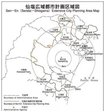
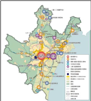
The City Planning Area covers only 25.7% of Japanese territory but 91.6% of the population live in the area. However, it has to be careful that the City Planning Area is not always specified to a whole area of a municipality but there are 4 cases how to set it (Fig.4). Accoeding to
figure 4, Senen extensive city planning
area corresponds to the case 4. How to
designate the city planning area is depends on the situation of the municipalities. The purpose of specify the City Planning Area is to make public
investments more efficient and promote the land use reasonably and soundly. It is effective to designate the City Planning Area for the following reason. At first it will be regarded as a target for Area Division (terms described 2.4). Second, the developments in the area are demanded the development permissions. Third, it is applied to the group rule which is a stipulation of the relationship between buildings and cities in the Building Standards Law.
Fig. 2. An example of the City Planning Area
2.3. The regulation of land use
In the City Planning Area, it becomes to be possible to divide the area into two areas, Urbanization Promoting Area and Urbanization-restricted Area (the City Planning Law, Article 7). According to the City Planning Law, the Urbanization Promoting Area is defined as an area which already forms urban area and should be urbanized preferentially and systematically during about 10 years and
the Urbanization-restricted Area is
National Land Use
Planning Law (Individual method)
City Planning Areas
Agricultural Promotion Areas
National Forests
Local Forests with Regional Forest Plan
National Park
Prefectural Nature Park
Wilderness Natural Environment Conservation Areas
Natural Environment Conservation Areas
Prefectural Naturale Environment Conservation Areas National Land Use
Planning
National Planning
Prefectural Planning
Municipal planning
Land use master plan
City region
Agricultural region
Forest region
Natural park region
Nature conservation region
Local Autonomy Act.
Municipal Basic Concept National Spatial Planning Act.
National Spatial Planning
City Planning Law
Act for Improvement of Agricultural Promotion Areas
Forest Law
Natural Parks Law
Nature Conservation Act Land transaction
control
Fig. 3. The national planning system in Japan
City Planning Area
Administrative Area City Planning Area
Administrative Area
Case 1: City Planning Area combined with Administrative Area
Case 3: City Planning Area is a part of Administrative Area
Town B
City A City C
Town D
City Planning Area
Border of Administrative Area Town B
City A City C
Town D
City Planning Area
Border of Administrative Area
Case 2: A City Planning Area consists of a number of municipalities
Case 4: A City Planning Area consists of a number of municipalities and a part of it is outside of City Planning Area
Fig. 4. 4 cases to spe cify the city planning area
A City Planning Area (divided)
B City Planning Area (undivided)
Use district
Urbanization Promoting Area
Outside of the use district in undivided city planning area
Developable
Urbaniation-restricted area
Undevelopable
Outside of City Planning Area
Large urban cities have to mandatory divide the City Planning Area into two areas. This area division is effective to centralize the public investments in the Urbanization Promoting Area and control certain amount of developments in the Urbanization-restricted Area. On the other hand, local cities can choose whether divide the City Planning Area or not, because once the area divided, it turns to be more difficult to develop in the Urbanization-restricted Area. As options for Undivided City Planning Area, there are 12 different kinds of “Use Districts” in which control the purpose of land use and its figure. Local cities which is not divided in the City Planning Area can designate the Use Districts selectively and control developments because in Undivided City Planning Area, all developments are allowed in principle.
According to the City Planning Law, Article 29, a person who is planning to use land for development action should get permission from prefectural governor. The target size of each development action is different between in the Urbanization Promoting Area, the Undivided City Planning Area and outside of the City Planning Area and development action is required to meet technical standards. Additionally in Urbanization-restricted Area, there are strict locational criteria and few development actions which meet the criteria can be constructed.
zzzzzzzzzzzzzzzzzzzzzzzzzzzzzzzzzzzzzzz zzzzzzzzzzzzzzzzzzzzzzzzzzzzzzzzzzzzzzz zzzzzzzzzzzzzzzzzzzzzzzzzzzzzzzzzzzzzzz zzzzzzzzzzzzzzzzzzzzzzzzzzzzzzzzzzzzzzz zzzzzzzzzzzzzzzzzzzzzzzzzzzzzzzzzzzzzzz
zzzzzzzzzzzzzzzzzzzzzzz
Urbanization Promo ting Area
-which already forms urban area and should be urbanized preferentially and system atically in about 10 years
Urbanizatio n-res tricted Area
-which should be c ontrolled urbanization
The City Planning Area
Fig. 6. The Area Division
2.4 The use districts and group rule of buildings
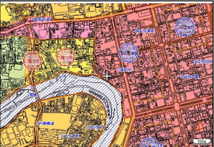
There are 12 kinds of use districts - 7 kinds of residential districts, 2 kinds of commercial districts and 3 kinds of industrial districts - prepared in the City planning law and these districts can be supecified in the Urbanization Promoting Area and the Undivided City Planning Area selectively. Each district controls the land use (Fig.7). For example, hotels cannot be developed in Category 1 exclusive low building residential zone. Depends on the objective of each district, it can be possible to decide the building coverage, floor-space ratio, height limitation, floor-floor-space ratio limitation of road, diagonal line limitation for road and adjacent land and shadow area limitation.
Fig. 7. The use district of a part of Sendai ci ty
and city, surrounding environment not a building itself. It is deeply related with the City Planning Law. For example it sets out use control which decides the usage of the district.
Fig. 8. The City Planning Area Master Plan, The layout plan of major facilities
Fig. 9. The Municipal Master Plan, The zoning plan and location plan of hubs in the city
3. The master plans In the Local Autonomy Law, each
municipality is required to make
fundamental plan which describes basic ideas and purposes as a text to put into practice their own town management and plans. Differ from the fundamental plan there are “City Planning Area Master Plan” and “Municipal Master Plan” as texts including drawn plans. The City Planning Area Master Plan is applied to each City Planning Area and decided by
prefectural governments (Fig.8). It
describes the objective of city planning and whether to divide the City Planning Area into the Urbanization Promoting Area and the Urbanization-restricted Area or not. It also describes the principle for conducting the land use and city facilities in City Planning Area. The City Planning Area Master Plan is usually a larger scale plan than the Municipal Master Plan and reflects it. On the other hand the Municipal Master Plan is made in each municipality as a text including drawn plans and its
contents must correspond to the
fundamental plan and the City Planning Area Master Plan (Fig9). It describes the grand design of a city, for example the ideal images of the road ahead and problems that should be overcame. It also describes the regional designs which are plan and strategy of smaller part of the city. Both City Planning Area Master Plan and Municipal Master Plan are not mandatory regulations but just plans
which describe the direction of
developments in each area and
municipality. However these are as important as the basic plans.
how to adjust the district is planned with this system.
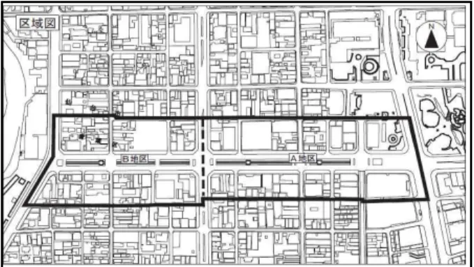
Fig. 10. An exam ple of district planning of jozenji street district in Sendai City
Fig. 11. The contents of regulation in district plan
Fig. 12. The contents of regulation in district plan
For example in Sendai City, there are 93 districts which have district plans. Jozenji
street district (Fig.10), one of the 93 districts in Sendai City, decides its own regulation for developments of buildings. In particular, [A] Use control is set up in this plan and the facility of entertainment, dance hall, love hotel, gas stand and so on are not allowed to be built (Fig.11). [B] ground-floor area is set up more than 200
m2. [C] Back space from edge of ground is
also decided. [D] Height of a building must be more than 10 m. [E] The shape and design of a building must consort wooden street. [F] The fence of a building must be considered surrounding environment. This district is aiming to be a stronghold that
creates new culture and environment for communication in Sendai City.
5. Problems of Japanese cities Nowadays many cities in Japan are facing on problems such as existence of multi-occupied zone with tall buildings and decrepit wooden houses, while scattering of unused lands in the middle of urban area. In surrounding part of the urban area, many residential complexes have been developed and there are many sprawling developments in Urbanization-restricted area because of exceptional rules for development (Fig.13).
Additional expansion of urban area might cause increase of the unused lands,
declination of city center and
disappearance of prime agricultural lands
under the situation of anticipated
population decrease in Japan. One of the methods of solution is “Compact City”. Some cities including Sendai City are aspiring to make the range of urban area more compact. For example in Sendai City Master Plan, the basic objectives to develop Sendai City are described as switching form to more intensive urban area, building up city function and locate it appropriately and developing the quality of urban space from various aspects. Sendai City aims to deliver these objectives and change to be a more convenient and economic city (Fig.14).
Present Future
Fig. 14. The image of becoming compact city
5. Conclusion – The great east Japan earth quake 11. March, 2011, a massive 9.0-magnitude earthquake hit the Tohoku area in Japan. Many lives were claimed and hundreds of thousands of houses were damaged or lost by the earthquake and tsunami which hit the coastal area of east Japan. In addition, lifelines such as the public transportation system commencing with rail and road, sewerage systems and electric, water and gas supply were shredded. The damage is unparalleled in Japanese history of previous disasters. The most damaged areas were Iwate
prefecture, Miyagi prefecture and
Fukushima prefecture.
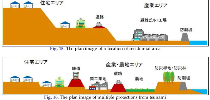
Half year has passed since 3.11, each prefecture and municipality has been drawing up the basic plans toward recovery. In Miyagi prefecture, the final
plan of earthquake disaster reconstruction has decided 17 on August. The term of the plan to recovery is 10 years (until 2021). In 10 years, there are 3 years of restorative stage, 4 years of regenerative stage and 3 years of developing stage. One of the main idea of recovery and prevention from tsunami is described the figure15. Miyagi prefecture has decided to relocate coastal residential area to more upland and separate from industrial area. In industrial area, the evacuation buildings which have high elevation will be built to evacuate from tsunami (Fig.15). Figure16 describes the idea of multiple prevention from tsunami. The coastal levee and green space will be located in the sea shore. Roads and railways are planned to locate every border of agricultural area, commercial and industrial area and residential area. Actually, there was a fact that the limited
intruding in the urban area (Fig.16). The most impressive points of this plan is that it aims not only restoration of devastated area but also drastic restructuring of the whole prefecture and it is also trying to resolve the problem with the modern Japan such as population decline, the aging
population, preservation of the
environment, symbiosis with nature and
creation of safe and confortable
communities.
The recovery of east Japan has just started. There must be a lot of barrier which we
have to get past and various ways of planning will be needed.
REFERENCES
Fig. 1, Geospatial Information Authority on Japan Fig. 2, Senen extensive city planning area in Miyagi
prefecture
Fig. 7, Department of city planning of Sendai city Fig. 8, Senen extensive city planning area master
plan in Miyagi prefecture
Fig. 9, Sendai City Master Plan in Sendai city Fig. 10, 11, 12, The district plan of jozenji street in
Sendai city Fig. 13, Google map
Fig. 14, Sendai City Master Plan in Sendai city Fig. 15, 16, The basic plan of recovery in Sendai city
Fig. 15. The plan image of relocation of residential area
Fig. 16. The plan image of multiple protections from tsunami